Biloxi, MS Existing Conditions, Issues, and Trends … · Biloxi, MS Existing Conditions, Issues,...
78
1 | Page Biloxi, MS Existing Conditions, Issues, and Trends Report City of Biloxi Comprehensive Plan (Text Only Version) 1. Introduction 1.1 Purpose of the Comprehensive Plan The City of Biloxi has changed significantly since its most recent Comprehensive Plan was adopted in 1996. The mid-1990s marked the start of a decade of population growth and prosperity in Biloxi. During this period, Biloxi’s resort and hotel industry developed and grew. The City and its residents invested in new schools and technology, transportation, heritage and culture, historic neighborhoods, affordable housing, public safety, and recreation. Then Hurricane Katrina massively impacted the City in 2005, destroying over 20% of Biloxi’s homes and businesses. The peninsula, in particular, suffered considerable damage. As residents and businesses began to rebuild, a series of plans were prepared with significant public involvement to guide the recovery process. Examples include the Reviving the Renaissance Plan, A Reconstruction Plan for Biloxi, and the East Biloxi Community Plan. Public and private investment in the City following Hurricane Katrina is moving forward, but is occurring without the benefit of an overarching vision and strategy that ties together the many plans that have been prepared and initiatives that are underway. The primary purpose of the new Comprehensive Plan is to provide a common direction or “roadmap” that can be used to proactively manage future change. The Plan will articulate goals, objectives, and strategies that establish a city’s vision for the future and how it is to be implemented through planning policy, capital investments, and regulatory tools. A comprehensive plan addresses all aspects of the municipality, including land use, transportation, housing, recreation and open space, natural resources, public utilities, schools, health and safety, historic preservation, and economic development. Biloxi’s Comprehensive Plan will present a community-wide framework that defines how the many elements of the City and post-Katrina initiatives will fit together to support a common vision and purpose. The Comprehensive Plan will integrate previous planning efforts and reflect consensus developed through public involvement. This plan will provide: • A reflection of community values and aspirations expressing what Biloxi will be; • A guide for managing change; • A reference point for policy-making; and • A direction for actions to be taken to implement the plan.
Transcript of Biloxi, MS Existing Conditions, Issues, and Trends … · Biloxi, MS Existing Conditions, Issues,...
1 | P a g e
Biloxi, MS Existing Conditions, Issues, and Trends Report
City of Biloxi Comprehensive Plan (Text Only Version)
1. Introduction
1.1 Purpose of the Comprehensive Plan
The City of Biloxi has changed significantly since its most recent Comprehensive Plan was adopted in 1996. The mid-1990s
marked the start of a decade of population growth and prosperity in Biloxi. During this period, Biloxi’s resort and hotel industry
developed and grew. The City and its residents invested in new schools and technology, transportation, heritage and culture,
historic neighborhoods, affordable housing, public safety, and recreation. Then Hurricane Katrina massively impacted the City in
2005, destroying over 20% of Biloxi’s homes and businesses. The peninsula, in particular, suffered considerable damage.
As residents and businesses began to rebuild, a series of plans were prepared with significant public involvement to guide the
recovery process. Examples include the Reviving the Renaissance Plan, A Reconstruction Plan for Biloxi, and the East Biloxi
Community Plan. Public and private investment in the City following Hurricane Katrina is moving forward, but is occurring
without the benefit of an overarching vision and strategy that ties together the many plans that have been prepared and
initiatives that are underway.
The primary purpose of the new Comprehensive Plan is to provide a common direction or “roadmap” that can be used to
proactively manage future change. The Plan will articulate goals, objectives, and strategies that establish a city’s vision for the
future and how it is to be implemented through planning policy, capital investments, and regulatory tools. A comprehensive
plan addresses all aspects of the municipality, including land use, transportation, housing, recreation and open space, natural
resources, public utilities, schools, health and safety, historic preservation, and economic development.
Biloxi’s Comprehensive Plan will present a community-wide framework that defines how the many elements of the City and
post-Katrina initiatives will fit together to support a common vision and purpose. The Comprehensive Plan will integrate
previous planning efforts and reflect consensus developed through public involvement. This plan will provide:
• A reflection of community values and aspirations expressing what Biloxi will be;
• A guide for managing change;
• A reference point for policy-making; and
• A direction for actions to be taken to implement the plan.
2 | P a g e
The legal authority under which Biloxi can prepare its comprehensive plan is found under Section 17-1-1 of the Mississippi Code
of 1972, as amended. Mississippi requires that the plan, at a minimum, include:
• Goals and objectives for the long-range (20-25 years) that address, at a minimum, residential, commercial and
industrial development; parks, open space and recreation; street or road improvements; public schools and
community facilities;
• A land use plan with projections of population and economic growth for the planning area;
• A transportation plan, depicting all existing and proposed improvements, which shall be a basis for a capital
improvements program; and
• A community facilities plan, depicting housing, schools, parks and recreation, public buildings and facilities, and
utilities and drainage, which shall be a basis for a capital improvements program.
1.2 Purpose of the Existing Conditions, Trends, and Issues Report
The purpose of the Existing Conditions, Trends, and Issues Report is to frame the key issues and trends facing Biloxi today and in
the future. This Report is essential in the comprehensive planning process and will provide the foundation for developing the
Plan’s goals, objectives, strategies, and implementation actions as the process moves forward. This report is organized into the
following sections:
Chapter 1.0 (Introduction) summarizes the purpose of the Comprehensive Plan and this report on Existing Conditions, Trends,
and Issues.
Chapter 2.0 (Planning Areas) describes the different geographic scales addressed by the Comprehensive Plan. These include
Biloxi’s larger regional context and four neighborhood planning areas within the City: East Biloxi, West Biloxi, North Biloxi, and
Woolmarket. Downtown Biloxi is addressed as a special focus area. In addition, Chapter 2.0 introduces the Planning Area
delineated in the 1996 Comprehensive Plan, which was defined as “that territory into which the municipality could logically
choose to expand during the Plan’s time horizon.”
Chapter 3.0 (Land Use, Natural, Historic, and Cultural Resources) covers a wide range of topics, including natural and
aquatic resources; historic and cultural resources; land use and development issues and trends; zoning; and vacant land. It
describes the historical development of Biloxi, the effects of Hurricane Katrina, and the current land use pattern of the City.
Chapter 4.0 (Transportation) provides an overview of Biloxi’s transportation system, including the roadway network and
classifications of different types of roadways; planned transportation improvements; waterways and fishing and boating facilities;
and pedestrian, bicycle, and transit facilities.
Chapter 5.0 (Community Facilities and Services) addresses different types of facilities and services provided to Biloxi’s
residents, including police, fire, and emergency services, solid waste collection, utility systems, park and recreation facilities,
libraries, and schools.
Chapter 6.0 (Demographics and Housing) provides current demographic and housing data and summarizes recent trends and
population/housing projections. The Biloxi Housing Authority facilities and resources are also described in this Chapter.
Chapter 7.0 (Economic and Employment Analysis) describes important economic sectors and trends, major employers, and
retail sales trends.
3 | P a g e
Chapter 8.0 (Previous Plans) summarizes existing plans for Biloxi, including the City’s previous Vision 2020 Comprehensive
Plan, Reviving the Renaissance Plan (which has guided rebuilding and development after Hurricane Katrina), and the Harrison
County Comprehensive Plan. Other regional and local plans are described as well.
Chapter 9.0 (Community Input) was prepared following the completion of the initial public input process, which is essential to
developing a meaningful Comprehensive Plan. This chapter summarizes the results of a statistically valid telephone survey,
stakeholder interviews and focus groups, and findings from the first series of public workshops. It also introduces common
themes and issues that emerged from the community input sessions.
The Comprehensive Plan addresses the City of Biloxi at several different scales, including the current municipal boundaries,
Biloxi’s broader regional planning context, and geographic subareas within the City. The remainder of this report discusses
issues and trends related to each of these levels in greater detail.
2. Planning Areas
2.1 City of Biloxi
The City of Biloxi is located within Harrison County, in the Gulf Coast region of Southern Mississippi. Figure 2.1 shows the
present city limits. Biloxi’s coastline lies along the Mississippi Sound, which is separated from the Gulf of Mexico by a string of
barrier islands. The City is about 46.5 square miles, of which 82% is land and 18% is water.
Biloxi’s major east-west highway is U.S. Highway 90 (Beach Boulevard), which runs along the coastline connecting the city to
Gulfport on the west and Ocean Springs and Pascagoula to the east. Another major east-west corridor is Interstate 10, which
connects Biloxi with New Orleans and other major cities in the Gulf Coast region. I-10 is also an important hurricane evacuation
route for the region. Located in the adjacent City of Gulfport, the Gulfport-Biloxi International Airport provides further regional
access. Biloxi is also situated along the Gulf Intracoastal Waterway, a major maritime shipping and boating corridor that extends
along the Gulf Coast from Carrabelle, FL to Brownsville, TX. East-west and north-south rail service is provided by CSX and Kansas
City Southern Rail Lines. Biloxi is located along the Sunset Limited transcontinental train line, which travels between Los Angeles
and Orlando. However, Amtrak passenger service from Biloxi’s downtown station is temporarily suspended due to Hurricane
Katrina damage.
Biloxi abuts the City of Gulfport to the west, unincorporated Harrison County to the north, and the City of D’Iberville to the east.
It is part of the larger Gulfport-Biloxi Metropolitan Area, which includes three counties: Hancock, Harrison, and Stone. Figure
2.1 City of Biloxi illustrates the City’s municipal boundary, its major waterways, roadways, bridges, and the CSX rail line, another
major east-west transportation corridor.
2.2 Regional Context
This Comprehensive Plan is an update to the Biloxi Vision 2020 Plan, which was adopted in 1996. The 1996 Plan identified the
City’s Planning Area as the land within Biloxi’s municipal boundary and also land to the north within unincorporated Harrison
4 | P a g e
County (see Figure 2.2 Planning Context). The 1996 Plan identified the land to the north as the territory into which Biloxi could
logically choose to expand over a 20-year period.
One population trend occurring in the Gulf Coast region is a shift to the north away from the coastline. Even before Hurricane
Katrina hit Biloxi in 2005, population was shifting from the traditional East Biloxi neighborhoods to West and North Biloxi. This
shift is continuing north of I-10 as infrastructure and services are improved. A pending annexation case and a proposed
development indicate the current “path of growth”. The annexation case would expand the city limits to a 12-square mile area
north and east of the Biloxi’s existing boundary located partially outside of the Planning Area delineated in the 1996 Plan. Belle
la Vie is a proposed mixed-use development of approximately 1,138 acres located inside and outside of Biloxi’s present northern
boundary and within the Planning Area designated by the 1996 Comprehensive Plan. Both proposed areas are shown on Figure
2.2 Planning Context.
An important outcome of this Comprehensive Plan will be to identify an updated Planning Area within which the City could
logically choose to expand in the future. While the DeSoto National Forest provides an apparent barrier to northward expansion,
additional growth is possible along the Highway 15 and 67 corridors between forest holdings (see Figure 2.2). One important
issue is the character, density, and form of new development that would be appropriate within the City’s greater Planning Area.
2.3 Neighborhood Planning Areas
For planning purposes, the City is divided into four neighborhood subareas: East Biloxi, West Biloxi, North Biloxi, and
Woolmarket (see Figure 2.3 Neighborhood Planning Areas). Both East and West Biloxi are located on the peninsula between
the Mississippi Sound and the Back Bay of Biloxi. A major federal government facility, Keesler Air Force Base, is located between
these two neighborhoods. East Biloxi is the oldest part of the City and was the most severely affected by Hurricane Katrina.
North Biloxi is located north of the peninsula between Back Bay and the Tchoutacabouffa River and west of D’Iberville and I-110.
West Biloxi, the site of the Mississippi Coast Coliseum and Convention Center, is accessible from the north via the Popp’s Ferry
Bridge and from the south via Highway 90. The Woolmarket Neighborhood Planning Area, located north of Tchoutacabouffa
River and mostly north of I-10, was annexed into Biloxi in 1999. Given its higher elevations, the majority of Woolmarket is
located outside of the 100-year floodplain. The development pattern in Woolmarket is predominantly rural or low-density
residential.
This Comprehensive Plan will identify short- and long-term strategies for the development, revitalization, and conservation of
each of the identified neighborhood planning areas.
2.4 Downtown
Located within the East Biloxi Neighborhood Planning Area, Downtown Biloxi is an important part of the City’s history and
heritage. The boundaries of Biloxi’s downtown core and greater downtown area as designated by the Biloxi Main Street
Association are identified on Figure 2.4 Downtown Focus Areas. The Downtown has a large concentration of historic and
government buildings. Many buildings were damaged by Hurricane Katrina and are being repaired or demolished. Vieux
Marche, a pedestrian shopping street, is the heart of the downtown district. Drawing on previous planning initiatives, including
5 | P a g e
the recent Downtown Biloxi Economic Development Framework, the Comprehensive Plan will identify a Downtown Renewal
Implementation Strategy for this special focus area.
3. Land Use, Natural, Historic, and Cultural Resources This chapter is organized into two primary sections: 3.1 History of Biloxi and 3.2 Biloxi Today. It covers a broad range of material,
including the historical development of Biloxi, natural resources, historic and cultural resources, land use, zoning, and current
development trends. These subjects are closely related, and for that reason are combined into one chapter. Key Findings are
presented at the beginning of this chapter with more detail and background provided in the following sections.
Key Findings
• Biloxi’s waterways, which played a defining role in the development of the City, remain tremendously important to
the City’s sense of place, culture, heritage, economy, and the health of its natural resources.
• Tourism and the commercial seafood industry are two economic sectors that shaped Biloxi’s development from a
small port city into a premiere tourist destination. Both industries remain important to the City’s economy and
heritage.
• Hurricane Katrina’s destruction significantly changed Biloxi’s land use pattern. A comprehensive framework to
guide the ongoing redevelopment effort must take into account future storm threats, revised and expanded
floodplain boundaries, infrastructure, and public safety.
• The health of the region’s natural systems (aquatic resources, wetlands, tree cover, conservation areas, plant and
animal habitat, woodlands, etc.) is key to sustaining local heritage, culture, economy, and environmental health.
• Natural resource preservation and restoration of coastal wetland and bayou ecosystems promote resiliency from
storm threats, improve the ecological health of the natural systems, and support the economy.
• Pending changes to the floodplain regulations present challenges to rebuilding in East Biloxi and other areas of the
City. To comply with regulations and obtain flood insurance, buildings must be built above the base flood
elevation or if non-residential, can be floodproofed. Rebuilding in a designated flood hazard area introduces issues
related to cost, required building heights, safety, and impacts on natural resources.
• Commercial development has, in some cases, limited views and public access to the waterfront.
• Environmental issues facing the nation are extremely relevant in the Gulf Coast region. Many coastal cities are
anticipating the impacts of climate change over the next 50 to 100 years. Scientific studies point to trends which
include temperature increases, sea level rise, warming ocean temperatures, loss of wetlands, and increasing
occurrences of severe storms. There are four basic types of strategies to address storm vulnerability: protection
through structural solutions, preservation or restoration of “natural” lines of defense such as wetlands and sand
dunes, (re)building to standards designed to minimize damage to individual buildings, and relocation of
development outside of vulnerable areas. In general, resilient land uses are required in flood hazard areas.
• Abundant historic resources and Biloxi’s close ties to its past are a regional asset. The City has historic preservation
standards and regulations in place to protect these important resources.
6 | P a g e
• A number of historic and cultural resources were damaged or destroyed as a result of Hurricane Katrina. As
redevelopment occurs, the City faces the challenge of preserving its culture and history in the context of casino and
tourism related development, particularly along Highway 90.
• A museum district (Ohr-O’keefe Museum of Art, Biloxi Maritime and Seafood Industry, Mardi Gras Museum) is
emerging east of downtown along Highway 90. These institutions will expand the availability of local cultural
resources and tourism offerings.
• Growth and redevelopment are occurring throughout the City. In particular, there are significant development
pressures in the more rural areas of Woolmarket. Water and sewer infrastructure expansion is planned north of I-
10 and commercial and office uses are growing at key intersections along I-10. Much of the land in this area is
zoned Agricultural or Residential Estate, requiring minimum lot sizes between 1 and 2 dweling units per acre. If
approved, annexations and development proposals will increase population. In addition, environmental and
economic constraints to rebuilding in East Biloxi suggest that residential development will continue to move north.
A long-term land use vision for this area is lacking, resulting in piecemeal development proposals.
• Major commercial uses are located on Pass Road, Highway 90, and in casinos. There are few retail or
neighborhood shopping options for residents in North Biloxi and Woolmarket.
• With the exception of some of the older neighborhoods in East Biloxi, there is little mixed-use development in Biloxi.
National trends, such as the rising cost of transportation, energy, food, and gas, are an incentive for people to live
within walking distance of services, schools, transit, and employment.
• Many historic and other downtown buildings and businesses were severely damaged by Hurricane Katrina. This
presents an opportunity to redevelop downtown with public amenities, such as improved walking, biking, and
public transit options. Also, there is an opportunity to promote green buildings and use of design guidelines.
• As residents rebuild homes in East Biloxi, they are required to elevate structures to heights above the base flood
elevation. This has slowed the progress of rebuilding while creating an urban design and accessibility challenge.
• The seafood industry in Biloxi is struggling. Many businesses and facilities were damaged by the hurricane.
Appropriately sized docks and associated facilities for ships, fuel, ice and unloading equipment are needed to
support the industry. The health and diversity of water resources and fish are essential for the industry.
• The expansion of the Convention Center District is expected to be completed in 2009. With this expansion, there
is a need for additional hotel rooms, recreational and tourist amenities, and entertainment.
• Casinos rebuilt quickly after the storm. Now there is a need to diversify land uses, offer tourism and entertainment
options, and increase open space and recreation on the peninsula. Diversifying and providing new entertainment
options will offer a better quality of life for residents and help to establish Biloxi as a premiere destination.
• Biloxi’s zoning largely reflects the existing land use pattern, with the exception of undeveloped land in Woolmarket
that is zoned commercial or office.
• Zoning regulations lack some tools commonly used to encourage alternative development patterns, such as
conservation design, mixed-use development outside of downtown, and traditional neighborhood design.
• About 50% of Biloxi’s total land is vacant as a result of Hurricane Katrina, undeveloped, or in agricultural use.
About 47% of vacant land is subject to environmental constraints, such as the 100-year floodzone, steep slopes, or
other characteristics which make it less suitable for development. Approximately 76% of the vacant or
undeveloped land that does not have environmental constraints is located in Woolmarket.
7 | P a g e
This chapter is organized into two primary sections: 3.1 History of Biloxi and 3.2 Biloxi Today. It covers a broad range of material,
including the historical development of Biloxi, natural resources, historic and cultural resources, land use, zoning, and current
development trends. These subjects are closely related, and for that reason are combined into one chapter. Key Findings are
presented at the beginning of this chapter with more detail and background provided in the following sections.
3.1 History of Biloxi
This section provides an overview of the history and development of Biloxi as a city. The second part details Hurricane Katrina’s
massive impacts on the City, its land use, natural and cultural resources.
3.1.1 Development of Biloxi
Mississippi’s Gulf Coast and inland waterways have attracted explorers and settlers for hundreds of years. The first coastal
Native Americans employed the Gulf Coast waterways as important trading and travel routes between villages. Deer Island,
located off the coast of Biloxi, was once used as an important ceremonial site. Attracted by the calm waterways of the
Mississippi Sound while in search of the mouth of the Mississippi River, French explorers arrived at Biloxi Bay in 1699. While
British and Spanish settlements followed, the area retained its strong French influence during the colonial period.
The land use pattern of modern-day Biloxi and other Gulf Coast cities has been strongly influenced by its location along
important waterways and its blending of cultures. Native Americans fished the coastal waterways and farmed the riverbanks
long before European settlers arrived. The seafood industry later became an essential part of the region’s identity and culture, as
it developed in the 1800s and continued to attract new immigrants to the coast.
The City of Biloxi was officially incorporated in 1838 as a township and quickly evolved into a summer resort town with several
hotels, including the Biloxi House, American Hotel, and the Magnolia Hotel - which pre-Katrina housed Biloxi’s Mardi Gras
Museum.1 Even as hotels and boarding houses developed and tourism grew, the City remained entirely dependent on its
waterways for travel and commerce until the completion of the railroad in 1870. With the development of the railroad, Biloxi’s
central commercial area shifted from Lameuse Street, which had provided access to goods delivered by boat, to Pass Christian
Road (now Howard Avenue). As the seafood industry grew, an important commercial district developed between Reynoir and
Main Streets and linked the railway system to the factory districts along the Back Bay and at the eastern tip of the Biloxi
Peninsula, Point Cadet.2
A string of barrier islands and sandbars separate Biloxi’s southern coast line from the Gulf of Mexico and is responsible for the
relatively calm waters of the Mississippi Sound. This unique combination of islands, saltwater, and fresh water supports a wide
1 Mississippi Gulf Coast National Heritage Area Management Plan, Mississippi Department of Marine Resources, Biloxi, MS, (December 2005). 2 Vision 2020 Plan, City of Biloxi (1996)
8 | P a g e
variety of marine life.3 The abundant fish population led to growth in the seafood industry, with Biloxi’s first fish cannery
opening in 1881. The industry grew quickly and by 1900 Biloxi had earned the reputation of “Seafood Capital of the World.”
Biloxi continued to grow as Polish, Austrian, Cajun, and other immigrant groups arrived to work in the seafood trade.4 In the
1970s and early 1980s, Vietnamese immigrants moved from New Orleans to work in the seafood industry. As the population
grew, Vietnamese American neighborhoods and businesses concentrated along the Back Bay and on Point Cadet.5 This
blending of cultural and ethnic identities has shaped the City’s land use and cultural identity.
Through the 20th century, major infrastructure improvements included the construction of a seawall along the coast line in 1928,
the creation of Sand Beach, construction of Highway 90 (Beach Boulevard), development of the Edgewater Mall, and the
development of the Keesler Air Force Base.6
Given its location and low-lying land, the Gulf Coast is extremely vulnerable to hurricanes. In 1969, Camille caused
unprecedented destruction along the coastline. In the years following Hurricane Camille, residents and business owners slowly
rebuilt. In 1992, dockside gaming was legalized by the State of Mississippi. By law, gaming facilities had to be permanently
docked in the water, but their associated lodging, restaurants, and entertainment buildings could be located on land. Once
approved, casinos developed at a rapid pace, building on Biloxi’s history as a tourist destination. New regional entertainment
venues, restaurants, and retail stores developed with the casinos. During this period of growth, the city also invested in schools,
transportation, historic neighborhoods, affordable housing, public safety, and recreation.
3.1.2 Hurricane Katrina
Everything changed when Hurricane Katrina struck the Gulf Coast in 2005. The storm massively impacted the City, destroying
6,000 of the 25,000 homes and businesses in Biloxi. Katrina caused 238 deaths in the state of Mississippi, 58 of which were
Biloxi residents. Entire neighborhood blocks were destroyed or severely damaged and numerous historic buildings were lost
forever. Much of the City’s infrastructure was destroyed, including the US 90 Bridge between Biloxi and Ocean Springs. The
gaming industry, the City’s largest employer, was severely affected. In East Biloxi, the most severely damaged area of the City,
an estimated 80% of the housing stock was either lost or uninhabitable, including two-thirds of Biloxi’s public housing units.7
Figure 3.1 Hurricane Katrina Damage Assessment illustrates Hurricane Katrina property damage determined to be greater than
50 percent. Storm recovery of residential and non-residential properties is contrasted with properties not yet repaired in Figure
3.2 Storm Repairs. This map is based on citywide permit data from September 2005 through May 2008.
Despite this unparalleled destruction, public and private investment throughout the City is well underway. Residents and
businesses have made a major commitment to rebuilding, and the City and community groups, with significant public
3 Mississippi Gulf Coast National Heritage Area Management Plan, Mississippi Department of Marine Resources, Biloxi, MS, (December 2005). 4 “Biloxi History” http://www.city-data.com/us-cities/The-South/Biloxi-History.html Source: Harrison County Library. 5 Schmidt, Aimee. “Down Around Biloxi: Culture and Identity in the Biloxi Seafood Industry”. Mississippi Folklife. Vol 28, Number 2 6 “Biloxi History” http://www.city-data.com/us-cities/The-South/Biloxi-History.html Source: Harrison County Library. 7 East Biloxi Community Plan, Biloxi Relief, Recover and Revitalization Center, June 2006.

9 | P a g e
involvement, have prepared plans to guide the process. To aid in the recovery, the State allowed gaming establishments to
rebuild on shore within 800’ of the mean high water line. The first casinos reopened in Biloxi just four months after Katrina, a
significant factor in the City’s recovery efforts. Major progress has been made in implementing the Revising the Renaissance
Plan (2006), the City’s blueprint for recovery and rebuilding after Katrina. Numerous plans and studies have been prepared
following Katrina (see Section 8 of this report). An important principle that is echoed in many of these plans is the opportunity
to rebuild a better and safer city than before. With this in mind, the Comprehensive Plan will build on the goals and policies
developed in the previous plans and create an overall framework and set of goals and strategies to guide Biloxi’s development
into the future.
3.2 BILOXI TODAY
This section provides a review of the City as it is today, including summaries of natural resources, historic and cultural resources,
land use, development trends, vacant land, and the trends occurring in each of Biloxi’s neighborhood planning areas.
3.2.1 Natural Resources
Biloxi is largely defined by its location and its environmental features, especially its water resources. The City is situated along
the Mississippi Sound and at the mouth of the Back Bay of Biloxi. Major waterways include the Biloxi River and the
Tchoutacabouffa River. Not only do Biloxi’s water features literally shape the City’s boundaries, they also have supported its
development and growth in fishing, trading, shipbuilding, and tourism. The natural and scenic resources of Biloxi continue to
attract residents and visitors and are key to the local heritage, culture, and economy.
The topography of the peninsula portion of Biloxi (south of the Back Bay) ranges between 2’ and 20’ above sea level to a high
ridge of 25’ to 30’ along the north side of the CSX railroad line, generally on either side of Pass Road.
East Biloxi is generally lower in elevation than West Biloxi and includes tidal marsh areas (freshwater, brackish, saline, and
intermediate marsh) around its perimeter and in inland depressions. North Biloxi and Woolmarket are characterized by a more
rolling topography with elevations ranging between 30 and 60’ above sea level. The highest altitudes in Biloxi are found in the
Woolmarket area, generally west of Highway 67 and north of Woolmarket Road where elevations reach about 60’. This
increasing rise in topography continues north of the City’s boundaries and into the De Soto National Forest.
Aquatic Resources
Biloxi’s water resources are part of a complex regional network. Maintaining high quality resources is essential to sustaining both
natural systems and human life. The rivers of the Gulf Coast flow directly into the Mississippi Sound or the Gulf of Mexico.
Rivers, estuaries, surface water, bayous, wetlands, and other shallow waters are all part of the larger water system.
Estuaries. Estuaries separate the freshwater rivers and streams from the Gulf of Mexico. The Back Bay of Biloxi (which
separates the peninsula from North Biloxi) and Biloxi Bay (which separates Biloxi from Ocean Springs) are important estuarine
10 | P a g e
water bodies in the region. The bays perform numerous functions, including seafood production, wildlife and fish habitat,
recreation, and scenic views.
According to multiple nationwide studies, a large percent of coastal wetlands has been lost to development. The Gulf Coast
states possess the largest proportion of coastal wetlands still in existence today. These areas continue to be threatened by
development, leading to loss of coastal habitats and placing significant pressure on the environmental resources and fishery
stocks of the Gulf Coast. The quality of these resources is dependent on the overall quality of water in the region, which in the
past has been exposed to high levels of pollution. In recent years monitoring of water quality has increased and findings indicate
that pollution remains in more extensively developed areas. In Biloxi, the City has been addressing water quality impairment
caused by polluted stormwater runoff since 2003 (see Chapter 6). Protecting and improving the Biloxi Bay and other regional
estuarine bays, lakes, and tidal streams is a key component of the state’s Comprehensive Conservation Strategy.8
The Biloxi River Marshes Coastal Preserve, located partly in Biloxi and partly in Gulfport, follows the edge of the marsh along the
Biloxi River and the Tchoutacabouffa River. Marshes and tidal wetlands within this area are excellent feeding and winter habitats
for migratory birds. Other rare and endangered species have been found within the preserve. The area is managed by the
Mississippi Department of Marine Resources and contains state-owned and privately owned land.
Mississippi Sound. The Mississippi Sound extends from the southern coastline of Mississippi to a chain of barrier islands that
mark the boundary of the Gulf of Mexico. The barrier islands provide some protection from storm surges and waves from the
Gulf of Mexico. A protected navigation corridor, the east-west oriented Gulf Intracoastal Waterway is maintained by the Army
Corp of Engineers. This channel is heavily used by both commercial and recreational ships. Water quality of local beaches is
monitored and tested by the Mississippi Department of Environmental Quality (MDEQ).
Floodplain and Wetlands. In 2005, Hurricane Katrina carried a record storm surge onto the Mississippi Coast causing
unprecedented destruction along the coastline. Since the damage occurred, numerous plans and studies have addressed
rebuilding and strategies for improving infrastructure, regional planning, and hazard mitigation (see Section 8). In 2006, the City
updated its Flood Damage Prevention Ordinance to better protect residents and businesses from storm related damage.
FEMA periodically updates Digital Flood Insurance Rate Maps (DFIRMS). Pending revisions to the FEMA maps will increase the
area of land within the 100-year floodplain (Special Flood Hazard Area). The revised floodplain maps include associated base
flood elevations (BFEs), the average surface water elevations resulting from a flood with a 1% change of occurring in any year.
This is an important number, since it dictates the elevation at which a building would need to be built to comply with the City’s
Flood Ordinance and obtain flood insurance for properties in hazard areas. However, it should be noted that areas outside of
the 100-year floodplain can also be impacted by flooding as demonstrated by Hurricane Katrina (see Katrina’s storm surge on
Figure 5-5 in Chapter 5). The floodplain area is most extensive on the peninsula and along the Biloxi and the Tchoutacabouffa
Rivers.
8 Mississippi Museum of Natural Science. 2005. Mississippi’s Comprehensive Wildlife Conservation Strategy. Mississippi Department of Wildlife, Fisheries and Parks,
Mississippi Museum of Natural Science, Jackson, Mississippi.
11 | P a g e
Figure 3.3 Waterways and Wetlands illustrates Biloxi’s water resources. In addition to the Mississippi Sound and bay waters,
large areas of marsh, wetland, swamp, or bog exist within the City’s boundaries.
Figure 3.4 Floodplains shows the boundaries of the draft flood zones, including the Velocity, 100-year, and 500-year
floodplains.9 Figure 3.5 Impact of Base Flood Elevations is based on an analysis of draft Base Flood Elevations (BFEs) over existing
grade. This figure estimates how high above grade a building needs to be built to be in compliance with the new DFIRM maps.
Above grade heights range from 15-17 feet along the Mississippi Sound, 11-12 feet along Biloxi Bay, and decrease as the
floodplain moves inward.
Other Natural Resource Areas
While Biloxi’s aquatic resources have visibly shaped its history and development and remain a key part of the City today, other
resources comprise part of the City’s larger natural system. Many of these resources, which include natural habitat, trees, and
native plants and animals, are concentrated in coastal preserves or forest land. Existing natural areas or preserves within the
greater Biloxi area are described below. Live oak trees, while not necessarily part of one preserve or management area, are a
well-known and important local resource and, for that reason, are also highlighted below.
Live Oaks and Tree Canopy. Live oaks are common throughout the sandy soils of the Gulf Coastal plains. The trees have a
distinct appearance with low wide-spreading limbs that branch out nearly horizontal to the ground. Used as a shade tree and
ornamental, the Mississippi Forestry Commission and the National Audubon Society note that live oaks are considered “one of
the noblest trees in the world and virtually an emblem of the Old South.”
Many live oaks were damaged as a result of Hurricane Katrina; however, many survived where buildings and homes were
destroyed. These native trees add tremendous scenic value along Beach Boulevard, in addition to helping to control erosion and
reduce stormwater runoff. The live oaks along the Highway 90 median were especially hard hit, experiencing damage and stress
as a result of Katrina.
There is a history of preservation of live oaks in the south; the first public forest land was purchased in 1799 to preserve their
habitat in the Carolinas and Georgia. Today the trees are valued as both a natural and cultural asset. The Sand Beach Authority/
Parkway Commission and the Department of Transportation are currently assessing each tree as part of a recovery plan to
address the remaining Hurricane Katrina damage.
In addition to live oaks, other native trees create Biloxi’s tree canopy, an important environmental resource. Trees provide many
benefits, such as natural cooling, improved air and water quality, and stormwater management. They also provide a visual
amenity and increase property values. Two organizations, the Land Trust for the Mississippi Coastal Plain and Replant Mississippi,
are working to improve tree health and increase the tree canopy in the Gulf Coast region. The City of Biloxi is also a Tree City,
USA and was one of the first cities in the state to adopt a tree protection ordinance.
9 Velocity zones are coastal hazard areas with a 1-percent chance of experiencing a flood event, with associated wave action and/or high velocity water, in any given year.
Areas within the 100-year floodplain (Special Flood Hazard Area) have a 1-percent chance of experiencing a flood event in any given year. The 500-year floodzone identifies
areas outside of the Special Flood Hazard Area that have a 0.2-percent chance of experiencing a flood event in any given year.
12 | P a g e
Sand Beach. The Sand Beach - Biloxi’s waterfront along the Mississippi Sound - has remained a popular tourist attraction and
regional amenity since construction of its seawall was completed in 1928. The Harrison County portion of the Sand Beach
stretches 26 miles across the coast and offers a range of recreational activities, including sunbathing, walking, swimming, pier
fishing, deep see fishing, and jet skiing. In addition to its obvious recreational and scenic qualities, the Sand Beach helps manage
coastal erosion. Harrison County first established its Sand Beach Master Plan and an Erosion Control Task Force in 1986. The
County completed an update of the Plan in 2008 following the destruction caused by Hurricane Katrina (see Section 8). The
Sand Beach Authority is currently undertaking repairs and improvements to many of the beach structures, piers, and boardwalk.
Coastal erosion remains an issue as wind and storms consistently blow sand from the beach onto Highway 90. The Army Corp
of Engineers periodically replaces this sand, in a process called renourishment. To improve its effectiveness in managing erosion,
the U.S. Army Corp of Engineers is developing dune vegetation along the 26-mile length of Sand Beach in Harrison County. The
new dunes will be planted with native grasses to help keep sand on the beach and off adjacent roadways. Once the dunes are
constructed, vegetation will be planted throughout the beach area.
Deer Island Coastal Preserve. Deer Island, which is located directly across from Point Cadet (the southeasterly most portion
of the peninsula), was purchased by the City in 1999 and then sold to the State of Mississippi. An important and diverse part of
the natural coastal habitat, the island provides aesthetic, protective, recreational, and educational benefits. Deer Island is
protected by the Mississippi Coastal Preserve Program. Through this program, the state is addressing environmental issues that
threaten the island, including erosion control.
De Soto National Forest. The largest forest district in the state, the De Soto National Forest covers about 591 square miles
across parts of ten counties. The southern part of the forest is located in Harrison County, approximately 1.5 miles north of the
Biloxi municipal boundary and accessible from Highway 49. Varied ecosystems exist within the forest, including dry, sandy
longleaf pine/scrub oak ridges and flooded tupelo/bald cypress swamps. De Soto offers a number of recreational activities,
including camping, canoeing, hunting, fishing, hiking, horseback riding, and ATV trails. Two wilderness areas, Black Creek and
Leaf River, are located within the forest. Mississippi’s only National Scenic River, the Black Creek is known for its wide, white
sandbars and scenic canoeing opportunities.10
Natural Resource Trends and Management
Environmental issues facing Biloxi extend beyond the need to protect natural resources and increase storm resiliency. A new
study prepared by the U.S. Department of Transportation examines the potential impacts of climate change (temperature
increases, sea level rise, and changes in weather patterns) and land subsidence on the infrastructure of the Gulf Coast region.11
Many coastal cities are anticipating the impacts of climate change over the next 50 to 100 years and considering the effects of a
2 to 4 foot sea level rise, increasingly intense hurricanes, an increase in average temperature, and more periods of intense
rainfall.12
10 USDA Forest Service, De Soto Forest District Website. http://www.fs.fed.us/r8/mississippi/desoto/ 11 Impacts of Climate Change and Variability on Transportation Systems and Infrastructure: Gulf Coast Study, Phase I. A Report by the U.S. Climate Change Science
Program and the Subcommittee on Global Change Research [Savonis, M. J., V.R. Burkett, and J.R. Potter (eds.)]. Department of Transportation, Washington, DC, USA. 12 “Warming could worsen many problems along the coast.” Mark Schleifstein. Times-Picayune. December 15, 2007.
13 | P a g e
In a broader context, there are many strategies to reduce the vulnerability of the Gulf Coast region to the impacts of a changing
climate and storm threats. A 2001 report, Confronting Climate Change in the Gulf Coast Region, recommends three basic
strategies: mitigation, minimization, and adaptation. The primary goal of mitigation is to reduce climate stresses, such as
greenhouse gas emissions. The minimization strategy seeks to reduce human disturbances and ecosystem destruction.
Adaptation is focused on education to raise awareness of issues related to climate change and the cultural heritage of the region
which is at risk. Employing these three strategies and involving private and public landowners can reduce the Gulf Coast
region’s vulnerability to the impacts of climate change and at the same time produce significant ecological, economic, and public
health benefits.13
Locally, Keesler Air Force Base is taking measures to minimize its impact on the environment. All of the 1,028 new residences
Keesler is building in Biloxi will be Energy Star certified and 748 of the new and redeveloped housing units will be LEED certified.
Keesler is also taking steps to reduce waste and carbon output in its day to day operations. For example, the Base recycled its
construction waste for use in artificial reef building in the Gulf of Mexico. Keesler also replaced vehicle patrol cars with bicycles,
converted vehicles to biodiesel, and is committed to planting three trees for every one tree destroyed by Katrina.
Raising awareness of issues related to storm vulnerability is a first step to achieving a sustainable future for the region. Biloxians’
and visitors to the Gulf Coast are inherently linked to the region’s waterways and other natural resources. Many residents are
dependent on the heath of waterways for employment. In addition, Biloxi’s cultural heritage and economic health are linked to
the region’s ecological systems. The City has witnessed first hand the destruction of catastrophic storms, such as Hurricanes
Camille and Katrina.
There are three basic types of local strategies to address storm vulnerability: protect, (re)build to standards, or relocate.
Protection strategies include the use of structural solutions (e.g., levees or floodwalls) to protect developed areas from storm
impacts. (Re)building strategies are code requirements (e.g., elevation and floodproofing) designed to minimize damage to
individual buildings. Relocation strategies aim to prevent storm damage by relocating development out of vulnerable areas. In
addition, there is growing recognition that removal of “natural” lines of defense (e.g., wetlands and sand dunes) has increased
the susceptibility of man-made development to flooding and storm damage. Combinations of different types of strategies to
reduce storm vulnerability will likely be discussed in the next phase of planning. With this in mind, the goals, objectives, and
strategies of the Comprehensive Plan will set the direction for Biloxi to be a resilient and sustainable city in the 21st century.
3.2.2 Historic and Cultural Resources
The City of Biloxi has been shaped by the aquatic resources and the diverse influences of its early inhabitants. Today’s
environment is a multi-ethnic mix of people and traditions of Native American, European, African, and Asian descent. The
region’s historic and cultural heritage is evident in its historic buildings, places, archaeological sites, waterways, traditions, and
festivals. A common theme echoed throughout the development of this Comprehensive Plan and in previous plans is the
importance of retaining Biloxi’s sense of place, people, and traditions for future generations.
13 Twilley, R.R., E.J. Barron, H.L. Gholz, M.A. Harwell, R.L. Miller,D.J. Reed, J.B. Rose, E.H. Siemann, R.G. Wetzel and R.J. Zimmerman (2001). Confronting Climate
Change in the Gulf Coast Region: Prospects for Sustaining Our Ecological Heritage. Union of Concerned Scientists, Cambridge, Massachusetts, and Ecological Society of
America, Washington, D.C.
14 | P a g e
Historic Resources
The oldest parts of Biloxi were settled on the peninsula, in and around what is now East Biloxi. The City’s commitment to
preserving its more than 300-year history and unique character is apparent in the designation of local historic zoning overlay
districts and landmark sites and its longstanding Architectural and Historic Review Commission (AHRC). The AHRC administers
design review for any proposed changes to a building or lot designated as a local landmark site or located within a local historic
district. Regulations also apply to properties within 300 feet of any landmark, landmark site, or historic district. The local historic
overlay districts are located along the Mississippi Sound shoreline and are shown on Figure 3.6 Historic Districts and Landmark
Sites. They include, moving from east to west: Point Cadet; East Central; Downtown; West Central; West Beach; and Edgewater
Park.
Three of the City’s historic overlay districts (Downtown, West Beach, and West Central) are also listed on the National Register of
Historic Places. In addition to the six historic overlay districts, there are 174 designated landmarks in Biloxi. The design review
guidelines emphasize preservation over complete remodeling and apply to all buildings within a locally designated district
regardless of age or architectural style. The AHRC can apply the guidelines with more flexibility for non-historic buildings (those
less than 50 years old or substantially altered) than for historic structures. In addition to the local regulations, there are state and
national listings which support Biloxi’s historic resources.
• Mississippi Landmark Properties. The Mississippi Landmark designation is the highest form of recognition bestowed
on properties in the state and provides protection against alterations which could affect historic character. The program
typically applies to publicly-owned properties; however, private owners can nominate historically significant properties for
long-term preservation. Grants, matching funds, and emergency disaster funds may be available for listed properties. In
Biloxi there are 38 properties designated as Mississippi Landmarks, some of which are also listed on the National Register.
Some of these properties were either damaged or destroyed in Hurricane Katrina.
• National Register of Historic Places / National Historic Landmarks. There are 35 properties listed on the
National Register, about one-third of which were either seriously damaged or destroyed in Hurricane Katrina. While there
are no regulations associated with a listing on the National Register, it is a prestigious designation that can provide tax
advantages for owners and is an opportunity to celebrate Biloxi’s history.
As described in Section 3.1 above, many of the City’s historic structures and their surrounding neighborhoods were destroyed or
severely damaged by Hurricane Katrina. Some of these structures have been repaired since the storm. Restoration of Beauvoir,
a National Historic Landmark and the last home of Jefferson Davis, was completed in 2008 and the site is now open to the
public. The second phase of the project, which includes restoring the Jefferson Davis Library and botanical gardens, is underway.
While there are success stories, there are also many damaged or destroyed structures that have lost their historic value and are
not likely to be rebuilt. One challenge facing the City is the need to strike a balance between restoration and growth in a way
that respects Biloxi’s history and character, but also makes economic and environmental sense.
Heritage
Historic preservation is only one component of a broader strategy to protect Biloxi’s culture and heritage. With assistance from
the National Parks Service, the City’s Cultural Affairs Division is developing a Biloxi Heritage Tourism Program. In 2007, the
department completed a downtown walking tour brochure and began to develop directional signage, a historical driving tour,

15 | P a g e
information kiosk, and historical markers. The Biloxi Lighthouse, which survived Hurricanes Camille and Katrina and other major
storms, is a symbol of the City’s resiliency and heritage. Built in 1848, the lighthouse is reportedly the first cast metal lighthouse
in the South. Complete restoration of the interior of the lighthouse and long range plans for the development of a lighthouse
park are planned.
At the regional scale, the City of Biloxi is within the six-county Mississippi Gulf Coast National Heritage Area (see Chapter 8).
According to the National Heritage Area Management Plan, designation of this area became a priority as economic and
development pressures increased, most visibly along the coastline. The development of hotels, casinos, condominiums, and
retail businesses significantly altered the viewsheds of many sections of the Biloxi, Gulfport, and Bay St. Louis coasts. The policies
of the Mississippi Gulf Coast National Heritage Area Management Plan are intended to conserve the area’s unique heritage
resources in order to create a more livable and economically viable region.
Arts and Culture
In addition to history and heritage, the City’s museums, arts, theaters, and festivals are a source of pride, representing cultural
life in Biloxi. Cities across the U.S. are investing in cultural institutions and attractions as part of their economic development
strategies. A museum district is emerging along Beach Boulevard, east of downtown. Plans for the new Ohr-O’Keefe Museum
of Art, the Biloxi Maritime and Seafood Industry, and the Mardi Gras Museum are underway. Theater and other live events have
been successful in Biloxi in the past, and are continuing to grow. A number of festivals celebrating the City’s culture occur each
year. A few of the major arts and culture resources in the City are summarized below.
• Ohr-O’Keefe Museum of Art. The museum’s collection showcases George Ohr’s pottery and is temporarily located at
the Swetman House in West Biloxi, just north of Highway 90. The new museum campus, designed by architect Frank
Gehry, is located on Beach Boulevard and will include five separate buildings: Center for Ceramics, Welcome Center,
George Ohr Museum, Museum of African-American Art, and the Pleasant Reed House.14
• Biloxi Maritime and Seafood Industry Museum. Currently operating on the Schooner Pier Complex, the Museum
is considering relocating to land adjacent from the new site of the Ohr-O’Keefe Museum of Art. The museum was
destroyed by Hurricane Katrina but is planning to rebuild a new facility that includes a 22,000 SF building reflecting the
City’s historic seafood processing plants and industry. Currently the museum operates two 65’ Biloxi Schooners and a
children’s summer camp.
• Biloxi Mardi Gras Museum. Biloxi’s Mardi Gras museum, formerly located in the historic Magnolia Hotel, is in the
process of being relocated. Its collection of 300 years of Mardi Gras celebration on the Gulf Coast is being inventoried
with assitance from the National Endowment for the Humanities. Prior to Hurricane Katrina, the museum displayed
costumes, photographs and memorabilia of carnivals along the coast.
• Saenger Theatre for the Performing Arts and Biloxi Little Theater. There are a number of performing arts
productions held in Biloxi each year. The downtown Saenger Theatre, constructed in 1929, originally hosted early films,
shows, and vaudeville acts. Recently restored to its original condition, the Saenger is home to the Gulf Coast Symphony
Orchestra, local theater companies, and dance troupes. Another cultural resource, the Biloxi Little Theater, located on Lee
Street in East Biloxi, is celebrating 60 years of year-round community theater.
14 Construction of the Ohr-O’keefe Museum was about 50 percent complete when Hurricane Katrina hit in 2005.
16 | P a g e
• Annual Community Events. A number of events celebrating local heritage, culture, and history take place each year.
Important for both locals and visitors, such events include:
o Blessing of the Fleet and Shrimp Festival;
o Billy Creel Memorial Wooden Boat Show;
o Biloxi Seafood Festival;
o Cruisin’ the Coast;
o Great Biloxi Schooner Races;
o Mardi Gras Celebration;
o Mississippi Deep Sea Fishing Rodeo; and
o Smokin’ the Sound
3.2.3 Land Use and Development Trends
Biloxi originally developed on the eastern part of the peninsula and then slowly grew west and north across the Back Bay. Given
the damage that occurred with Hurricane Katrina, Biloxi’s land use pattern is somewhat unusual and difficult to characterize.
The percentage of vacant land use overall has increased significantly since the hurricane. As rebuilding proceeds, multi-family
and commercial development has occurred at a faster pace than single-family residential.
North Biloxi and Woolmarket experienced a lesser degree of storm damage than East Biloxi. Woolmarket, which was annexed to
Biloxi in 1999, remains the least developed and most rural part of the City. Infrastructure and transportation improvements to
support existing and future development are planned throughout the City, with new water and sewer service being expanded
along Highway 67, north of I-10. In the Woolmarket area, land is higher in elevation and generally located outside of the
floodplain. Given these conditions, new residential and commercial growth is occurring north of the peninsula, in both North
Biloxi and Woolmarket. The current state of transformation suggests that Biloxi’s land use pattern will likely continue to change
in the future.
Development Patterns
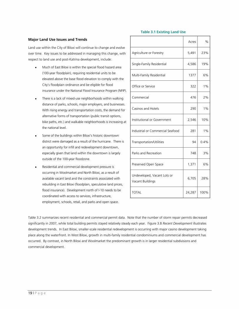
Existing land use in Biloxi is illustrated on Figure 3.7 Land Use. Table 3.1 shows the percentage and area breakdown by land use
type as of 2007. These categories are described below.
Agriculture or Forestry Related. Agriculture comprises about 20% of land use in the City of Biloxi. Generally located in the
Woolmarket area, land categorized as agriculture was annexed to the City in the last ten years. According to the 2002 Census
of Agriculture, there were 85 farms located in the City of Biloxi. The majority of farms were either woodlands (52%) or pasture
and rangeland (for raising cattle and horses). The remaining farms were classified as small orchards. None of the farms in 2002
were permanently preserved through conservation easements or other preservation techniques, meaning that they are subject to
development as Biloxi’s growth moves to the north. Therefore, they are treated as undeveloped land in the vacant and
undeveloped land analysis in Section 3.2.5.
17 | P a g e
Residential. Residential is the most extensive land use in Biloxi. Residential land uses take many forms, ranging from single-
family neighborhoods to condominiums along the beachfront to mobile homes in the more rural and wooded areas north of I-
10. The following residential forms occur in Biloxi:
• Single-family residential. Traditional residential neighborhoods with grid block patterns, small lots, and front yards are
found in West and East Biloxi. Many of the neighborhoods most extensively impacted by Hurricane Katrina followed
this form. Neighborhoods in North Biloxi and Woolmarket are more typical of post-WWII, suburban housing
developed along curvilinear streets and at a lower density than traditional residential neighborhoods.
• Two-family or multi-family residential. Based on 2007 assessment data, about 6% of the land in Biloxi is classified as
two-family or multi-family residential. Mobile homes and mobile home parks, which are spread throughout the City,
are included in this category. This land use category includes various forms of ownership, including rental, condo, or
owner-occupied units. Redevelopment and growth in multi-family condo units along Highway 90 is occurring as
tourism and the gaming industry continue to expand.
Commercial. Commercial land uses are found throughout Biloxi, but are mostly concentrated south of the Back Bay along
Highway 90, Pass Road, downtown, and in the casino district. In West Biloxi, major commercial uses include the Edgewater Mall
with over one million square feet of retail. The New Village at Edgewater, which was renovated after Hurricane Katrina, is
located directly across from the Edgewater Mall.
Biloxi’s downtown generally extends between Beach Boulevard and the Esters Boulevard/CSX right-of-way and Lameuse Street
and Interstate 110. The downtown core consists of attractive early 20th century architecture mixed with more recent retail and
government buildings. Many historic buildings downtown were damaged by the storm and are either being repaired or are
vacant. The typical commercial uses in downtown are specialty retailers and professional service/office buildings.
Big box retailers and smaller chains are located along busy roadway corridors such as Cedar Lake Road and Popp’s Ferry Road.
These corridors are in close proximity to residential neighborhoods in North Biloxi and Woolmarket. Smaller commercial
corridors and nodes located throughout the City serve the needs of local residents. As casinos continue to expand, Biloxi’s
commercial land uses have experienced growth in the service-oriented business category.
Office or Service. Office or service land uses are found throughout Biloxi in a variety of development types, ranging from
converted residential buildings to smaller office buildings. Land uses in this category include legal offices, medical offices, and
construction-trade services.
Institutional. Overall, Biloxi has a high percentage of institutional land uses. The largest institutional land use in Biloxi, Keesler
Air Force Base, is also the City’s principal employer. Other uses in this category include schools, local and state municipal
buildings, the Biloxi Regional Medical Center, the VA Hospital, and the Cedar Lake Medical Park. Churches, cemeteries, and
community facilities are also included in this category.
18 | P a g e
Casinos and Hotels. Biloxi is home to eight casinos, including Missisisppi’s first casino, the Isle of Capri. Casinos are a major
commercial and entertainment use in the City providing tax revenue, employment, and gaming facilities that support tourism.
The State sets regulations related to casinos; in Biloxi facilities can be located along the waterfront in areas zoned waterfront (WF)
and within 800 feet of the mean high tide line. In addition to gaming rooms, casinos often include high-end retailers,
restaurants, and other convenience-type stores.
Many smaller hotels and motels were damaged or destroyed following Hurricane Katrina, resulting in a shortage of rooms
available to serve the visitor industry. Hotel rooms are located within most of the casino establishments. There are also stand-
alone facilities, generally located along Highway 90.
Industrial or Commercial Fishing. Historically a very strong industry in Biloxi, land uses related to fishing and seafood
production, including shrimping boats and processing plants, severely declined following Hurricane Katrina. However, seafood
continues to be a viable industry in Biloxi as shrimp populations rebounded in the 2007 season, attracting shrimpers to the City’s
waterways. Seafood processing occurs in East Biloxi, generally located on the Back Bay, along Bayview Avenue or Division Street.
Commercial shrimping boats are generally located on the Back Bay, between Lee and Main Streets. In addition to seafood
processing and related businesses, there are areas of industrial land use which include warehousing, trucking, and light
manufacturing.
Parks or Recreation. There are neighborhood and community parks and recreation fields located throughout the City,
ranging in size from ½-acre to 75 acres (Hiller Park - see Section 5.4). The City’s parks and recreational fields offer a range of
activities, such as playgrounds, ball fields, boat launches, and walking tracks. In addition to parks, recreational land uses in the
City include the Sand Beach (managed by the County’s Sand Beach Authority and open to the public) and public and private golf
courses.
Preserved Open Space. The City’s two coastal preserves, Biloxi River Marshes and Deer Island are classified as preserved open
space. Land in this category is environmentally sensitive and not suitable for most development. Recreational uses include
boating, fishing, and bird watching. Ownership of land within the preserves is both public and private.
Undeveloped, Vacant Land, or Vacant Buildings. This category includes land that is currently undeveloped and land that
is vacant, generally as a result of Hurricane Katrina. Vacant buildings are also included in this category (see Section 3.2.5 Vacant
and Undeveloped Land Analysis below for detailed information).
19 | P a g e
Table 3.1 Existing Land Use
Major Land Use Issues and Trends
Land use within the City of Biloxi will continue to change and evolve
over time. Key issues to be addressed in managing this change, with
respect to land use and post-Katrina development, include:
• Much of East Biloxi is within the special flood hazard area
(100-year floodplain), requiring residential units to be
elevated above the base flood elevation to comply with the
City’s floodplain ordinance and be eligible for flood
insurance under the National Flood Insurance Program (NFIP).
• There is a lack of mixed-use neighborhoods within walking
distance of parks, schools, major employers, and businesses.
With rising energy and transportation costs, the demand for
alternative forms of transportation (public transit options,
bike paths, etc.) and walkable neighborhoods is increasing at
the national level.
• Some of the buildings within Biloxi’s historic downtown
district were damaged as a result of the hurricane. There is
an opportunity for infill and redevelopment downtown,
especially given that land within the downtown is largely
outside of the 100-year floodzone.
• Residential and commercial development pressure is
occurring in Woolmarket and North Biloxi, as a result of
available vacant land and the constraints associated with
rebuilding in East Biloxi (floodplain, speculative land prices,
flood insurance). Development north of I-10 needs to be
coordinated with access to services, infrastructure,
employment, schools, retail, and parks and open space.
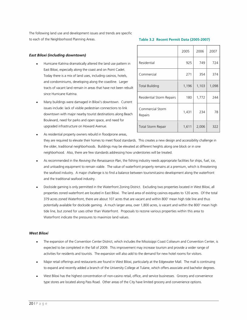
Table 3.2 summarizes recent residential and commercial permit data. Note that the number of storm repair permits decreased
significantly in 2007, while total building permits stayed relatively steady each year. Figure 3.8 Recent Development illustrates
development trends. In East Biloxi, smaller-scale residential redevelopment is occurring with major casino development taking
place along the waterfront. In West Biloxi, growth in multi-family residential condominiums and commercial development has
occurred. By contrast, in North Biloxi and Woolmarket the predominant growth is in larger residential subdivisions and
commercial development.
Acres %
Agriculture or Forestry 5,491 23%
Single-Family Residential 4,586 19%
Multi-Family Residential 1377 6%
Office or Service 322 1%
Commercial 476 2%
Casinos and Hotels 290 1%
Institutional or Government 2,546 10%
Industrial or Commercial Seafood 281 1%
Transportation/Utilities 94 0.4%
Parks and Recreation 748 3%
Preserved Open Space 1,371 6%
Undeveloped, Vacant Lots or
Vacant Buildings 6,705 28%
TOTAL 24,287 100%
20 | P a g e
The following land use and development issues and trends are specific
to each of the Neighborhood Planning Areas.
East Biloxi (including downtown)
• Hurricane Katrina dramatically altered the land use pattern in
East Biloxi, especially along the coast and on Point Cadet.
Today there is a mix of land uses, including casinos, hotels,
and condominiums, developing along the coastline. Larger
tracts of vacant land remain in areas that have not been rebuilt
since Hurricane Katrina.
• Many buildings were damaged in Biloxi’s downtown. Current
issues include: lack of visible pedestrian connections to link
downtown with major nearby tourist destinations along Beach
Boulevard, need for parks and open space, and need for
upgraded infrastructure on Howard Avenue.
• As residential property owners rebuild in floodprone areas,
they are required to elevate their homes to meet flood standards. This creates a new design and accessibility challenge in
the older, traditional neighborhoods. Buildings may be elevated at different heights along one block or in one
neighborhood. Also, there are few standards addressing how understories will be treated.
• As recommended in the Reviving the Renaissance Plan, the fishing industry needs appropriate facilities for ships, fuel, ice,
and unloading equipment to remain viable. The value of waterfront property remains at a premium, which is threatening
the seafood industry. A major challenge is to find a balance between tourism/casino development along the waterfront
and the traditional seafood industry.
• Dockside gaming is only permitted in the Waterfront Zoning District. Excluding two properties located in West Biloxi, all
properties zoned waterfront are located in East Biloxi. The land area of existing casinos equates to 120 acres. Of the total
379 acres zoned Waterfront, there are about 107 acres that are vacant and within 800’ mean high tide line and thus
potentially available for dockside gaming. A much larger area, over 1,800 acres, is vacant and within the 800’ mean high
tide line, but zoned for uses other than Waterfront. Proposals to rezone various properties within this area to
Waterfront indicate the pressures to maximize land values.
West Biloxi
• The expansion of the Convention Center District, which includes the Mississippi Coast Coliseum and Convention Center, is
expected to be completed in the fall of 2009. This improvement may increase tourism and provide a wider range of
activities for residents and tourists. The expansion will also add to the demand for new hotel rooms for visitors.
• Major retail offerings and restaurants are found in West Biloxi, particularly at the Edgewater Mall. The mall is continuing
to expand and recently added a branch of the University College at Tulane, which offers associate and bachelor degrees.
• West Biloxi has the highest concentration of non-casino retail, office, and service businesses. Grocery and convenience
type stores are located along Pass Road. Other areas of the City have limited grocery and convenience options.
Table 3.2 Recent Permit Data (2005-2007)
2005 2006 2007
Residential 925 749 724
Commercial 271 354 374
Total Building 1,196 1,103 1,098
Residential Storm Repairs 180 1,772 244
Commercial Storm
Repairs 1,431 234 78
Total Storm Repair 1,611 2,006 322

21 | P a g e
• Stretches of the Sand Beach boardwalk, damaged by Hurricane Katrina, will be repaired in the near future. In West Biloxi,
the majority of the Sand Beach is accessible for public use and retains open views.
• The Beauvoir House, located on Beach Boulevard, was recently rebuilt and is open to visitors. The surrounding grounds
and gardens will be renovated to their original condition over the next few years.
• West Biloxi is the fastest growing residential condominium market based on permit data. Condos are located along Beach
Boulevard and between Irish Hill Drive and Pass Road.
North Biloxi
• North Biloxi is a growing area of the City. Between 2005 and 2008, scattered residential and commercial development
occurred. The newly opened Biloxi Sports Complex is a major land use in this area.
• The I-10/Cedar Lake Road interchange is a major growth area in Biloxi. The Cedar Lake Medical Center is located here
and other commercial and office/service related uses are growing. There have been several commercial projects proposed
in this area.
• In North Biloxi, there are scattered vacant and unconstrained development sites, generally located around Popp’s Ferry
Road and Cedar Lake Road. Floodplains are limited to the edges of the Tchoutacabouffa River and the Back Bay.
• The Popp’s Ferry Bridge is an important connection between Biloxi (south of the Bay) and North Biloxi. Currently the
bridge opens to marine traffic about 10 times a day and carries an average of 20,000 vehicles a day. The City is
considering alternatives to replace and improve the bridge and an environmental assessment is underway.
Woolmarket
• The existing land use pattern is generally rural with a mix of single-family residential, mobile homes, undeveloped open
space, and agricultural land. There are few commercial services available for residents. Growth pressures are raising
issues related to the appropriate location and form of development in this area.
• Given existing constraints to redevelopment in East Biloxi and other areas south of I-10, development is likely to continue
to move north, where land and home insurance are more affordable to residents.
• Land along Highway 67 in Woolmarket is zoned highway commercial, business, or office, while the surrounding areas are
zoned either Rural Estate or Agriculture. Minimum residential lot sizes are between 20,000 SF and 1 acre, encouraging
large lot subdivisions that consume large amounts of land or proposals for rezoning to more intensive uses.
• City water and sewer service extension began south of I-10, after the Woolmarket area was annexed in 1999, and is now
planned north of I-10, along Highway 67. Over the next 2-3 years, installation of water and sewer service lines, water
wells, pump stations, and a new wastewater treatment plant to serve the Woolmarket area will be completed (see
Chapter 5). The availability of these services will increase development pressures in the area.
• In addition to sewer and water services, expanded fire and police coverage is planned.
• Other than the Biloxi River Marshes Coastal Preserve, which is managed by the state’s Department of Marine Resources,
there is little preserved open space or recreational parkland located in this area.
• There are two proposed annexations north of the City’s existing boundary: the Belle La Vie development and a large area
in Harrison County, northeast of the city’s municipal boundary. Belle La Vie, located about 1.5 miles west of Highway
67, is proposed as a master planned community with mixed-use neighborhoods, workforce housing, retail, office, and
a golf course. If approved as proposed, the project would add over 15,000 housing units over the next 10-15 years.
22 | P a g e
3.2.4 Development Regulations
Generalized existing zoning classifications are shown in Figure 3.8 Zoning. The pattern of existing zoning largely reflects Biloxi’s
land use pattern, with the exception of vacant land and areas east of Highway 67 in Woolmarket, which are zoned for
residential, commercial, or office uses and are currently undeveloped.
The City’s Land Development Ordinance (LDO), including the Zoning Ordinance and Subdivision Regulations, provides the City’s
primary tools for controlling the location, character, and intensity of development in Biloxi. Conditions and issues related to the
existing regulations include:
• Biloxi’s downtown core is zoned Central Business District (CBD), which permits a variety of residential and commercial uses.
Additional standards are required for some uses, such as day care centers, hotels, bars, and restaurants, allowing the City
more control over the particulars of the use, which might otherwise have a negative effect on their surroundings.
• There are six historic districts and numerous historic landmarks that require an additional level of review by Biloxi’s Historic
and Architectural Review Board. Design standards allow the Board more control over the appearance of new and
redeveloped buildings and help to improve overall character.
• The LDO contains three overlay districts, the Convention Center Overlay District, the East Biloxi Hospitality Overlay District,
and the Keesler Flight Overlay. In these districts, special allowances for lot density, structure height, FAR, and parking
requirements for properties zoned B-3 Hospitality Business or WF Waterfront may be permitted. The purpose of each of
these overlay districts is to encourage diverse visitor accommodations, preserve open space, and provide amenities beyond
the minimum requirements.
• The regulations lack some tools commonly used by other municipalities elsewhere in the U.S., for example:
• Provisions to encourage alternative development forms, such as conservation design, mixed-use districts outside of
downtown, traditional neighborhood design, and transit-oriented design.
• Design standards for development outside of the historic districts.
• Sand Beach is the only zoning district that specifically protects natural resources and open space. The LDO lacks
comprehensive natural resource protection standards.
• The majority of the Woolmarket Planning Area is zoned either estate residential, residential office, or business. Within
these districts there is little incentive to cluster new development, preserve open space, or create appropriate mixed-use
centers. Instead, there is the potential for residential developments to spread through rural areas at maximum densities
between 1 and 2.2 dwelling units/acre.
A more thorough evaluation of the LDO will be conducted separately as part of the process of updating the Zoning Ordinance
and Subdivision Regulations to implement the Comprehensive Plan recommendations.
3.2.5 Vacant and Undeveloped Land Analysis
Following Hurricane Katrina, over 20% of Biloxi’s homes and businesses were severely damaged or destroyed. Along the
coastline and in East Biloxi, the damage was much greater. An estimated 80% of the East Biloxi housing stock was either
destroyed or made uninhabitable. Since 2005, about 4,000 storm related repair or construction permits have been issued.
However, only 420 permits for new homes have been issued (compared to 6,000 homes lost to Katrina) and many properties
remain vacant or underutilized. There are a number of obstacles to redevelopment, including the cost of flood and wind
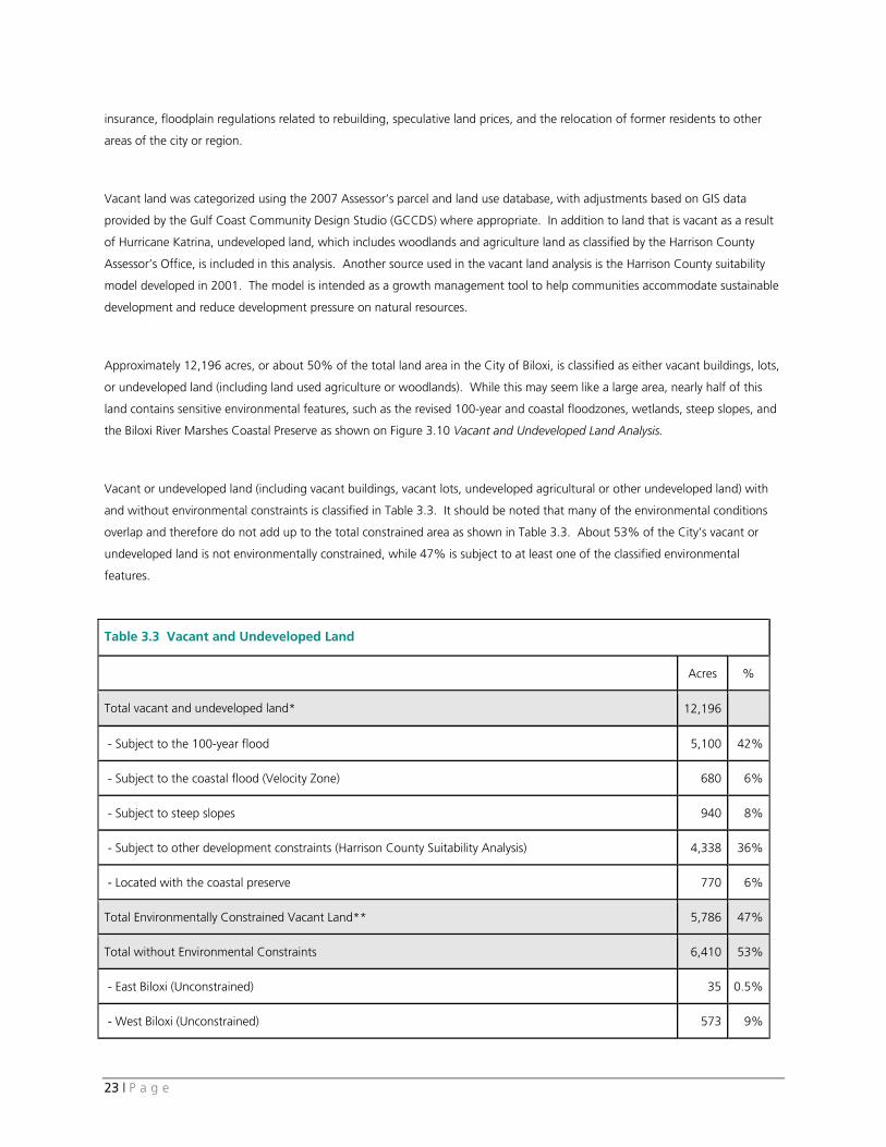
23 | P a g e
insurance, floodplain regulations related to rebuilding, speculative land prices, and the relocation of former residents to other
areas of the city or region.
Vacant land was categorized using the 2007 Assessor’s parcel and land use database, with adjustments based on GIS data
provided by the Gulf Coast Community Design Studio (GCCDS) where appropriate. In addition to land that is vacant as a result
of Hurricane Katrina, undeveloped land, which includes woodlands and agriculture land as classified by the Harrison County
Assessor’s Office, is included in this analysis. Another source used in the vacant land analysis is the Harrison County suitability
model developed in 2001. The model is intended as a growth management tool to help communities accommodate sustainable
development and reduce development pressure on natural resources.
Approximately 12,196 acres, or about 50% of the total land area in the City of Biloxi, is classified as either vacant buildings, lots,
or undeveloped land (including land used agriculture or woodlands). While this may seem like a large area, nearly half of this
land contains sensitive environmental features, such as the revised 100-year and coastal floodzones, wetlands, steep slopes, and
the Biloxi River Marshes Coastal Preserve as shown on Figure 3.10 Vacant and Undeveloped Land Analysis.
Vacant or undeveloped land (including vacant buildings, vacant lots, undeveloped agricultural or other undeveloped land) with
and without environmental constraints is classified in Table 3.3. It should be noted that many of the environmental conditions
overlap and therefore do not add up to the total constrained area as shown in Table 3.3. About 53% of the City’s vacant or
undeveloped land is not environmentally constrained, while 47% is subject to at least one of the classified environmental
features.
Table 3.3 Vacant and Undeveloped Land
Acres %
Total vacant and undeveloped land* 12,196
- Subject to the 100-year flood 5,100 42%
- Subject to the coastal flood (Velocity Zone) 680 6%
- Subject to steep slopes 940 8%
- Subject to other development constraints (Harrison County Suitability Analysis) 4,338 36%
- Located with the coastal preserve 770 6%
Total Environmentally Constrained Vacant Land** 5,786 47%
Total without Environmental Constraints 6,410 53%
- East Biloxi (Unconstrained) 35 0.5%
- West Biloxi (Unconstrained) 573 9%
24 | P a g e
- North Biloxi (Unconstrained) 919 14%
- Woolmarket (Unconstrained) 4,884 76%
* Total vacant land includes undeveloped agricultural land. ** Environmental features overlap and therefore do not add up to the total constrained vacant land
area.
Vacant or undeveloped land by planning area is characterized below.
• Proportionally to its planning area size, East Biloxi has the largest concentration of environmentally constrained, vacant
land. Not surprisingly, the major issue in this area is the 100-year and velocity floodplain boundary.
• West Biloxi has both environmentally constrained and unconstrained vacant land. Vacant land within the 100-year
floodplain, south of Pass Road, and the velocity zone along Highway 90 is constrained. North of Pass Road, there are
larger vacant parcels without environmental constraints.
• In North Biloxi, there are large parcels near Popp’s Ferry and Cedar Lake Road that do not seem to be environmentally
constrained. There are also areas of vacant/undeveloped land with environmental constraints, such as steep slopes (above
8%) or floodplains along the north side of the Back Bay. Other major constraints include the floodplain along the
Tchoutacabouffa River that forms the Planning Area’s northern boundary.
• The largest area of undeveloped land without environmental constraints is located in the Woolmarket Planning Area. Of
the total vacant/undeveloped land without environmental constraints in Biloxi, about 76% is located in Woolmarket.
25 | P a g e
4. Transportation
Key Findings
• Biloxi’s roadway system consists of a network of interstate highways, arterial and collector roadways, and local
streets. Major corridors in the City providing access that is vital to the economy, as well as to public health, safety
and welfare through emergency evacuation, include Interstate 10, Interstate 110, US Highway 90, Pass Road,
Popp’s Ferry Road, State Highway 67, and Cedar Lake Road (from I-10 to Popp’s Ferry Road). These roads are
designated as Principal Arterials.
• The continued growth of the City has stressed the capacity of some of the major corridors. This issue is magnified
because the evacuation capacity of the Biloxi Peninsula is limited by the capacity of a limited number of bridge
connections to the north and east and roadway connections to west.
• An issue related to the limited number of connections to the peninsula is lack of direct north-south connections
between Interstate 10 and Highway 90 other than I-110. In addition, east-west connections across the City and
the County are limited by various waterways (rivers and bays) and federal land restrictions (Air Force and Navy
bases).
• Access management controls on the number and location of curb cuts serving adjacent development are needed
to maintain traffic flow and safety along arterial roadways such as Highway 90 and Pass Road.
• There are many roadway projects planned or underway post-Katrina to improve access, mobility, capacity and
safety throughout the City.
• Pedestrian facilities destroyed by Hurricane Katrina are being reconstructed along Highway 90. The
pedestrian/bicycle path across the new Biloxi Bay Bridge is heavily used and there is tremendous potential to
develop additional pedestrian and bicycle facilities in the City as an alternative to automobile use.
• The Coast Transit Service (CTA) provides many services within the City of Biloxi, including fixed-route bus service,
paratransit service for seniors and persons with disabilities, and car and vanpool services. Like pedestrian and
bicycle facilities, there is potential to improve the transit services available in the City as an alternative to automobile
use. The CTA’s 2007 Gulf Coast Transit Development Plan identifies strategies to expand and improve transit
service in Biloxi and the Gulf Coast Region in the future.
• The City’s primary air service provider, the Gulfport-Biloxi International Airport, provides commercial, private and
cargo services to the residents, military personnel and visitors. Public transit (bus) service between Biloxi and the
airport is lacking.
• Marine resources, such as recreational facilities, commercial fishing industry, and the various marinas, harbors,
docks and piers, are important components of Biloxi’s transportation infrastructure that were significantly impacted
by Hurricane Katrina.
26 | P a g e
4.1 Introduction
This assessment of the City of Biloxi’s transportation system has been conducted three years following Hurricane Katrina. Prior
to Hurricane Katrina, the City was experiencing intensive development of coastal properties adjacent to Highway 90, including
condominium units, casinos, and supporting retail. Katrina’s landfall on August 29, 2005 changed Biloxi, the development
industry, and the City’s perception of its supporting transportation infrastructure.
The Biloxi Peninsula is accessed by several key bridges, including Highway 90 over Biloxi Bay, I-110 over the Back Bay, and Popp’s
Ferry Road over the Back Bay. Hurricane Katrina destroyed the Highway 90 Biloxi Bay Bridge, undermined and closed Highway
90, significantly damaged Popp’s Ferry Road Bridge requiring closure for over four months, and damaged the I-110 Bridge.
The City operated in a State of Emergency for over two years following Katrina’s landfall. Thousands of residents were displaced
during the hurricane’s aftermath, with thousands of homes damaged, many to the point that they have not been repaired.
Changes in the insurance industry and pending revisions to the FEMA flood elevations have significantly slowed the
redevelopment of the coastal areas that were impacted by the storm surge and flooding (see Chapter 3.0 for more information).
This has resulted in significant land areas that have not been built back since the storm, alleviating pressures on the available
traffic capacity of the roads serving them.
The City of Biloxi is in a rebuilding mode, both to replace aging infrastructure and to repair and improve the roadways and other
facilities that were damaged by the storm. Many transportation improvement projects are in progress or under consideration,
providing an opportunity for coordinated, long-range planning for a system that supports the future land use and development
pattern of the City. In that context, the following text assesses the current state of key components of Biloxi’s transportation
system, including streets and highways; pedestrian and bicycle circulation; transit service; air service; and boating, fishing, and
waterways.
4.2 Streets and Highways
The City of Biloxi’s roadway network includes federal, state, and local highways and streets. The Gulf Regional Planning
Commission (GRPC) develops the Long-Range Transportation Plan for the region (Gulf Coast Area Transportation Study, or
GCATS) and assists the Federal Highway Administration (FHWA) in the allocation of Federal funding. The Mississippi Department
of Transportation (MDOT) also processes funding requests for Surface Transportation Project (STP) applications through the Local
Public Agency (LPA) process. These funds are allocated to municipalities based on population.
4.2.1 Roadway Classifications
The City, GRPC, and MDOT work cooperatively in the designation of functional classifications of the City’s roadways. Using
definitions provided by the Institute of Transportation Engineers (ITE) Traffic Engineering Handbook, 5th Edition, pg 350-351, the
Functional Classification system is based on the following:
27 | P a g e
• Interstate Highways are designed to carry high volumes of traffic at high speeds and levels of service as is
practicable. Access is strictly limited to interchanges, which are carefully located and designed for maximum safety.
Longer-distance trips, including goods movement, use such facilities.
• Arterial Streets, including principal and minor arterials, carry traffic between important activity or population centers.
Arterial highways are typically designed with some measure of access control through limits on driveway locations and
spacing of intersections. Arterial streets carry both passenger car and commercial (truck) traffic.
• Collector Streets link the local street system with arterial highways. Such roads “collect” traffic, serve as local
through routes for short trips, and provide access to abutting land uses. Collector streets often appear similar to local
streets, although collector streets typically carry substantially higher volumes. Commercial traffic is typically limited to
local delivery uses.
• Local Streets provide access to the transportation network from developed land uses. The design character of these
roads reflects low speeds and traffic volumes. Accommodation of pedestrians within these streets should be a high
priority.
This classification system was utilized by the City, MDOT, and GRPC to designate the functional class of each of the City’s
roadways. This system is shown on Figure 4.1 Transportation Classification. Interstates 10 and 110 are maintained by MDOT.
Highways 67 and 90 require MDOT permits for access, but development of adjacent land must also meet the approval of the
City. Other arterial and collector streets shown on Figure 4.1 are Federal Aid streets.
4.2.2 Key Corridors
Biloxi’s sustained growth and rebuilding after Katrina have stressed the capacity of some of the City’s major corridors. The
evacuation capacity of the Biloxi Peninsula is limited by the capacity of the major bridges and connecting roadways. Key routes
providing access that is vital to supporting Biloxi’s economy, as well as public health, safety and welfare through emergency
evacuation needs, include Interstate 10, Interstate 110, US Highway 90, Pass Road, Popp’s Ferry Road, Highway 67, and Cedar
Lake Road (from I-10 to Popp’s Ferry Road). These roads are designated as Principal Arterials.
The adequate functioning of Biloxi’s key corridors is critical not only to mobility, but ultimately to the viability of Biloxi as a city.
Future development and economic productivity will be significantly hampered if transportation delays along these corridors
increase. Improvements are needed to maintain capacity and operation at posted speed limits. In addition, access management
controls are critical to ensure the continued operation of these facilities at acceptable levels. If uncontrolled access with
numerous curb cuts are allowed along these routes, the City will have excessive delays and gridlock when fully built out.
An important issue related to the key corridors is the limited number of north/south arterial roadways that connect Highway 90
and I-10 within the region, including (in addition to I-110 in Biloxi) Highway 49 and Cowan Road in Gulfport and Highway 609
in Ocean Springs. An indirect route within Biloxi follows Beauvoir Road, Pass Road, Popp’s Ferry Road, and Cedar Lake Road
from Highway 90 north to the Cedar Lake exit on I-10. Planning for a new Interstate connection between Highway 90 and I-10,
referred to as the East Harrison County Connector, has been discontinued, and current long-range plans do not include this
route.
28 | P a g e
Another issue is the lack of a continuous east-west corridor through Biloxi to provide an alternative to Highway 90, which
conveys heavy regional and local traffic volumes and (as noted) is vulnerable to storms. The limited north-south and east-west
connectivity of the regional arterial network causes increased pressures on existing corridors.
The following text provides an overview of issues associated with the City of Biloxi’s key corridors:
• Interstate 10: I-10 is currently being reviewed by MDOT as part of a multi-state improvement project that includes
Intelligent Transportation Systems (ITS) upgrades to improve interchange operations and to provide surveillance systems for
improved mobility during hurricane evacuations.15 Continued retail development in the vicinity of interchanges throughout
Harrison County has resulted in increased traffic with corresponding reductions in the capacity of the adjacent interchange
ramps. Interchange improvements are needed to maintain sufficient capacity to support anticipated future growth; for
example, the Cedar Lake interchange is currently operating near capacity. Additionally, future development plans in the
Woolmarket area are anticipated to warrant a new interchange at Shorecrest Road.
• Interstate 110: In the early 2000s, as GRPC and MDOT evaluated future transportation plans, I-110 was forecast to
exceed capacity due to casino and other growth along Biloxi’s waterfront. To alleviate this capacity deficiency, the East
Harrison County Connector was conceived as a new interstate connection to Highway 90 that would extend south from the
existing I-110/Highway 67 Road interchange. As noted, this program was removed from the regional Long-Range
Transportation Plan in 2007, prompting MDOT to commission a study to evaluate potential interchange and capacity
improvements to the I-110 corridor. Currently, the I-110 corridor is over capacity, primarily in the PM peak hours, during
which Keesler Air Force Base and other commuter traffic leaves the peninsula and a large portion exit at the D’Iberville
Rodriguez interchange. Auxiliary lane construction and capacity improvements are needed along I-110 to maintain
acceptable access and evacuation capacity for the community.
Development in the vicinity of Sangani Boulevard area in D’Iberville has increased the traffic volumes and delays at the north
(Highway 15) approach to the I-110/I-10 interchange. Retail development in the west quadrant of this interchange will
further decrease its capacity. In addition, opening of the final segment of the new Highway 67 connection by MDOT will
provide a limited access connection between I-110 and US Highway 49. This connection is anticipated to increase traffic on
I-110 and ultimately will require that a grade separated interchange be constructed at Sangani Boulevard to maintain
acceptable levels of service on I-110 to the south. Another issue is that the I-110 ramp to westbound Highway 90 does not
meet current design standards. Ultimately, the interchange will need to be reconfigured to improve both capacity and
safety.
• US Highway 90: Highway 90 is a vital component of the City of Biloxi’s transportation infrastructure. It is the only
principal arterial roadway that extends east-west across the Biloxi Peninsula from Ocean Springs to Gulfport. Keesler Air
Force Base restricts the potential to develop an additional east-west corridor or corridors on the peninsula. The CSX rail
15 Intelligent Transportation Systems (ITS) refers to the use of advanced computer and communications technology to enhance the operation and management of the surface
transportation system.
29 | P a g e
corridor, which runs along Keesler’s southern boundary, has been identified as a potential alternative, but this project has
not moved forward due to lack of funding and issues associated with its use as an active rail line.
During Hurricane Katrina, Highway 90 sustained major damage and significant portions of the roadway were closed within
Harrison County while emergency repairs were made. Traffic circulation was greatly impacted, as people were forced to
use Irish Hill Drive instead of Highway 90. Highway 90 has historically been an economic engine for the City; most major
casino and condominium developments are located along this corridor. Additionally, it provides regional connectivity to the
adjacent communities and serves as the only major regional east-west route south of I-10 in Mississippi. This dual role —
serving both regional and local traffic — adds to traffic congestion. MDOT is currently improving the Highway 90 corridor
and implementing access management strategies, including closures of driveways to businesses that were destroyed by
Katrina. The signal system is also being interconnected and coordinated to improve traffic movement.
• Pass Road: Access to West Biloxi and Keesler Air Force Base from the west is provided via Pass Road. This key east-west
roadway provides continuous access from Keesler to US Highway 49 in Gulfport, a critical link for the City when Highway
90 was closed following Katrina. Land uses adjacent to Pass Road are mostly built out but it is in need of upgrades to
maintain and improve vehicular movement. Past studies by the City have evaluated and developed designs for
improvements to many of the existing signalized intersections. The lane widths are narrow and the spacing of driveways
typically does not meet current access management standards. The limited right-of-way width has resulted in utilities being
placed within sidewalks and clear zones throughout the roadway corridor.
• Popp’s Ferry Road: The City has placed a high priority on improving Popp’s Ferry Road capacity as a critical connector
from the peninsula to Cedar Lake Road and I-10 in North Biloxi. Improvement projects have been implemented in stages
over the last 10 years, including widening of the segment between Cedar Lake Road and Riverview Drive to a five-lane
roadway and the segment from Riverview Drive to the Back Bay bridge to a three-lane roadway. Further improvements are
under development. Design plans have been developed for widening Popp’s Ferry Road to a five-lane roadway from Cedar
Lake Road east to the D’Iberville city limits. An Environmental Study is underway to evaluate widening Popp’s Ferry Road
from Riverview Drive south to Pass Road. In addition, the City has received proposals to evaluate an extension of Popp’s
Ferry Road south of the CSX Railroad to connect with Highway 90 by crossing the Coliseum property.
• Cedar Lake Road: Cedar Lake Road provides the primary connection between West Biloxi and I-10, as well as an indirect
connection to Highway 90, both via Popp’s Ferry Road. Retail development along the Cedar Lake Road corridor in recent
years has significantly increased traffic volumes. Ramp improvements and access management controls are needed to
maintain access and mobility for the corridor. The City recently interconnected the traffic signals at the I-10 interchange
and coordinated them with the adjacent signal to the south at Medical Park Drive. Additionally, the City has commissioned
a study of the interchange to identify improvements needed to increase capacity while providing access to the adjacent
property to the north and east.
30 | P a g e
4.2.3 Roadway Improvements
As noted, many roadway improvements are in various stages of planning and development throughout the City. These
improvements are shown on Figure 4.2 Transportation Improvements and summarized below. In general, they are listed in order
from programmed short-term projects to more speculative long-term projects. The numbers after each project represent the
map key (see Figure 4.2).
• New Highway 67 (1): This project is currently under construction by MDOT. A portion of this four-lane limited access
roadway is open from MS Highway 605 to Highway 49. When complete in Spring 2009, New Highway 67 will connect I-10
at I-110 to Highway 49, north of Saucier.
• Pine Street Extension (2): The Pine Street Extension is planned to complete the East Biloxi Transportation Loop, which
currently consists of Highway 90, Caillavet Street, Bayview Avenue and Back Bay Boulevard. This extension of Back Bay
Boulevard east and south to Highway 90 along the Pine Street alignment is planned as a four-lane divided roadway.
• Popp’s Ferry Road Widening from Cedar Lake Road to D’Iberville (3): This project is currently in the design phase.
The plans include widening Popp’s Ferry Road from a two-lane open ditch section to a five-lane curb and gutter section
with a center two-way left turn lane.
• Veterans Avenue Widening (4): Veterans Avenue is planned to be improved from a two-lane roadway to a four-lane
divided roadway. Intersection improvements at Highway 90, Irish Hill Drive, and Pass Road are planned as part of this
project, which is currently in the design phase.
• Highway 90 Service Drive from Camellia Street to Rodenberg Avenue (5): The service drive on the south side of
Highway 90 between Camellia Street and Rodenberg Avenue is currently being restored through the ongoing MDOT
Highway 90 project. MDOT is reclaiming the right-of-way from adjacent land owners that were utilizing the right-of-way as
an extension of their parking lots and is constructing the service drive to provide local access for the businesses while
limiting direct access to Highway 90.
• Pass Road Intersection Improvements (6): This phased project includes radius improvements, auxiliary lane
construction, and signal upgrades. Ultimately all the traffic signals along Pass Road in Biloxi will be interconnected to
operate with coordinated timings and major intersections will be widened to allow auxiliary turn lanes and improved lane
widths.
• Popp’s Ferry Road Extension to Highway 90 (7): The extension of Popp’s Ferry Road is planned in two phases: 1) a
connection from Pass Road to the Mississippi Coast Coliseum south of the CSX Railroad and 2) a connection from the
Coliseum to Highway 90. This project will improve traffic flow along Pass Road between Popp’s Ferry Road and Beauvoir
Road by providing a direct connection to Highway 90.
• Popp’s Ferry Road Widening from Riverview Drive to Pass Road (8): This project is in the preliminary stages of an
Environmental Assessment to analyze various route alternatives for the roadway widening. The construction of a new
Popp’s Ferry Road Bridge is planned as part of this project.
• Eisenhower Drive Realignment (9): Until recent years, Eisenhower Drive south of the CSX Railroad in West Biloxi was
a private street, providing access to the retail developments along this corridor. With the redevelopment of the adjacent
property, Eisenhower Drive has been dedicated to the City and is now a public street. The horizontal curve and the
southern terminus is planned to be improved through the ongoing Highway 90 reconstruction project to remove the abrupt
curve in the road and to provide a direct extension to Highway 90.
31 | P a g e
• Cedar Lake Road/I-10 Interchange Improvements (10): The City has commissioned a study to identify capacity and
circulation improvements to enhance traffic flow along Cedar Lake Road from Medical Park Drive to Easy Lane, including
the I-10 eastbound and westbound ramps.
• Spring Lane/I-10 Service Road (11): Connecting Cedar Lake Road to the D’Iberville city limits north of I-10 is included
in the Cedar Lake Road improvement study. In addition, a service road is proposed as an extension of Spring Lane to serve
new development along the I-10 corridor frontage.
• Bayview Avenue Widening from Caillavet Street to Lee Street (12): Improvements to Bayview Avenue from
Caillavet Street to Lee Street will support the completion of the East Biloxi Transportation Loop (see Pine Street extension
above). This project is planned to include widening of Bayview Avenue to a five-lane section with a center two-way left
turn lane and intersection improvements at Lee Street and Holley Street.
• Arterial Connection from Woolmarket to Popp’s Ferry Road (13): As an alternative to the highly-debated and
now discontinued East Harrison County Connector, this arterial roadway would provide an additional connection from
Woolmarket to areas south of I-10. The preferred route is an extension of Highway 67 (existing) across the
Tchoutacabouffa River to a connection at Popp’s Ferry Road in the vicinity of Jam Lane.
• Irish Hill Drive Extension to Greater Avenue (14): This proposed extension of Irish Hill Drive to the west would
improve the access to the residential area served by Greater and Southern Avenues. Currently, this neighborhood is
accessed by the unsignalized intersection of Iris Street at Pass Road and the signalized intersection of Camellia Street at
Highway 90.
• I-110 Southbound Loop Ramp at Bayview Avenue (15): The construction of a loop ramp that connects
southbound I-110 to eastbound Bayview Avenue in the southwest quadrant of the interchange would reduce congestion,
eliminate the traffic signal, and provide a free-flow movement from I-110 to Bayview Avenue.
• I-110 Improved Radius at Highway 90 (16): Improving the southbound I-110 to westbound Highway 90 ramp by
providing a wider horizontal curve would improve a deficient condition that results in traffic conflicts at Highway 90.
• Shorecrest Road/I-10 Interchange (17): With the growth of the City to the north, a new interstate interchange is
anticipated to be needed at I-10 and Shorecrest Road. This interchange would provide additional access for residents in the
areas of Eagle Point and west Woolmarket. The project is included in the GRPC Long-Range Transportation Plan.
• Shorecrest Road Improvements (18): The need for Shorecrest Road corridor improvements, in conjunction with the
new I-10 interchange, is tied to the current momentum of growth in Biloxi to the north. The potential improvements
include a boulevard corridor extending north of I-10 into Woolmarket. If high-density projects are proposed in this area of
the City, the extension of Shorecrest Road to the north will improve circulation and interstate access.
• Woolmarket Road Extension to O’Neal Road (19): The extension of Woolmarket Road west across the Biloxi River to
O’Neal Road in Gulfport would improve east-west connectivity in Harrison County. Currently there are only three east-west
crossings of the Biloxi River: I-10, Lorraine Road and Three Rivers Road. This project is included in the GRPC Long-Range
Transportation Plan.
• East-West Corridor (20): GRPC commissioned a supplement to the Long-Range Transportation Plan to address the
potential for a new east-west, multi-modal transportation corridor north of Highway 90 and south of I-10. As noted, such
a corridor is needed to provide an alternate route to Highway 90. This project has been referred to as the East-West
Corridor and a route immediately adjacent to and parallel to the CSX corridor has been identified. The next stage of the
32 | P a g e
study would be to conduct an environmental review, but no funding has been identified at this time to support such a
study.
• Lorraine Road Bridge Replacement (21): The Lorraine Road Bridge across the Biloxi River is planned to be replaced
through a joint project between the City of Biloxi and the City of Gulfport. The east bridge approach will be shifted to the
south and the roadway will be realigned to the east to improve its abrupt horizontal curvature.
4.3 Pedestrian and Bicycle Circulation
Prior to Hurricane Katrina, the primary area of pedestrian and bicycle circulation in Biloxi was along the Highway 90 corridor,
utilizing the Harrison County Sand Beach boardwalk and the sidewalks between the casinos. MDOT is currently restoring the
sidewalks along Highway 90 where right-of-way is available, as well as constructing sidewalks in some areas where they did not
exist before the hurricane. The Harrison County Sand Beach Authority is working to replace the wooden boardwalk that was
destroyed by Katrina with a concrete boardwalk throughout the County.
New roadway projects are being designed and constructed with pedestrian and bicycle friendly facilities. The new Biloxi Bay
Bridge has a 10-foot pedestrian/bicycle path that connects the City of Biloxi to the City of Ocean Springs. This path is heavily
utilized and provides the opportunity for connections to future pathways and trails serving the two cities.
4.4 Transit Service
Transit service in the City is provided by the Coast Transit Authority (CTA), a nonprofit and independently managed public utility
governed by a Board of Commissioners and supported by state and federal urban transportation funding. CTA currently
operates seven fixed route services, four of which are exclusively in the City of Biloxi. Transfer stations at the Biloxi Transit
Center in downtown and the Edgewater Mall provide riders with connections to routes serving Gulfport and Ocean Springs.
CTA also provides a curb-to-curb ADA/paratransit service for persons with disabilities who are unable to access or use the fixed-
route services. There is also a special services program for senior citizens. This program provides contracted services for special
trips, such as grocery shopping, medical appointments, senior centers, work centers, field trips, and transportation for area
nursing homes.
Fixed route service frequencies vary from 30 minutes (Keesler Route 24), to 45 or 90 minutes for the remaining six fixed routes.
The schedule frequencies are set to multiples of 45 minutes so that route schedules can be time-coordinated. The arrival and
departure times of all routes are coordinated at the two system transfer locations, one in Biloxi and one in Gulfport, to provide
transfer times of between five and ten minutes between all routes.
CTA discontinued several pre-Katrina fixed routes due to the low demand for services. Two routes in Biloxi, the Beach East and
Beachcomber routes, were terminated because of the destruction of residences and businesses along the routes.
CTA has also initiated the Coast Commuter service, a carpool and vanpool service targeted at long-distance commuters who
commute to jobs on the Gulf Coast. The carpool service is a “ride-match” system, in which riders are introduced to other
33 | P a g e
persons in their area as potential carpool members. The vanpool service makes vans available to groups of commuters, who can
share the responsibility of driving and associated operating costs, including van payment, gasoline, and parking.
In 2007 the CTA prepared the Gulf Coast Transit Development Plan to guide investment in the recovery, renewal, and rebuilding
of the region’s public transportation system post-Hurricane Katrina. This plan identifies strategies to expand and improve transit
service in Biloxi and the Gulf Coast Region in the future (see Chapter 8).
4.5 Air Services
The City of Biloxi is served by the Gulfport-Biloxi International Airport, located off Highway 49 one mile south of I-10 in Gulfport.
Service to and from the facility includes seven commercial airlines and a domestic and international air cargo facility. Additionally,
a general aviation service provides facilities for private charters and flight training. The airport is approximately 20 to 30 minutes
from most areas of Biloxi.
Various casinos, as well as Keesler Air Force Base, operate shuttle (bus and limousine) services for their patrons and military
personnel between Biloxi and the airport. Taxi services also provide transportation to and from the airport. CTA does not
currently provide fixed-route bus service as an alternative to private taxi and shuttle services.
4.6 Boating, Fishing and Waterways
The City of Biloxi has many industries that depend on the access to the Mississippi Sound and the bays and rivers that surround
this coastal community. The seafood industry, charter fishing, casino industry, recreational and commercial boating facilities are
water-dependent uses that experienced some of the worst damage from Katrina. An inventory of the City’s causeways, piers,
boat ramps, docks, fishing piers and marinas was compiled through discussions with the City’s Port Director and is shown in
Figure 5-5 Boating, Fishing, and Water Recreation (see Chapter 5).
34 | P a g e
5. Community Services and Utilities Key Findings
• Biloxi is well served by its police and fire safety services. The Police and Fire Departments are anticipating expansion
and increased demand as population continues to grow and public water and sewer are extended north into
Woolmarket. Any areas annexed to the City will need additional police and fire services and facilities.
• The City works closely with the County and National Weather Service to provide flood and storm information and
emergency warnings, and to reduce risk to residents and property.
• Hiring skilled, trained staff is an issue for both the Police Department and for some of the health care providers in
the City. With high housing and insurance costs and regional competition, hiring and retaining quality staff can be
an issue. Both school districts in the City are seeking ways to increase workforce and technical training among
graduates.
• Quality health care options in Biloxi and the region are growing. A range of medical services and providers are
located in Biloxi, including the new Cedar Lake Surgery building in North Biloxi and the Coastal Family Health Clinic
on the peninsula. The Biloxi Regional Medical Center is partnering with Tradition, a master planned community
located north of the City limits, to provide new medical facilities. This is another indication of growth momentum
to the north.
• With the exception of much of Woolmarket, the City is well served by public water and sanitary sewer service with
adequate capacity to meet future demands. Currently the major area of the City for new residential and
commercial development is North Biloxi due to the availability of vacant land coupled with public sewer and water
service. Over the next five years the City will extend water and sewer lines along Highway 67 north of Interstate 10
into unserved areas of Woolmarket. Together with a planned new wastewater treatment plant, these
improvements will promote new development in the Woolmarket area.
• The impacts of sanitary sewer and stormwater facilities on water quality and quantity (runoff from developed areas
during storms) are issues of concern given the importance of Biloxi’s waterways to its economy and quality of life
and the City’s vulnerability to flooding. The City is addressing these issues on an ongoing basis through initiatives
such as the Stormwater Pollution Prevention Plan and repair or replacement of sewer, water, and storm drainage
facilities damaged by Katrina.
• The City has increased its parks space and recreational programming over the last decade. While residents are well
served by parks, community surveys indicate a need for increased activities for seniors and children.
• Many cities are looking beyond parks and recreational programs to establish connected trails and greenway
networks. Biloxi lacks a continuous open space network of greenways, bike paths, and recreational paths.
• The Ports Division, part of the Parks and Recreation Department, is rebuilding and improving Biloxi’s marinas, docks,
and public piers. There is high demand for use of both recreational and commercial marinas.
• As the number of casinos and recreational offerings expands, the demand for boat slips is increasing. Biloxi is
strategically positioned between Texas and Florida and has the potential to draw increased recreational boating
traffic.
• As with other community facilities and services (police, fire, public water and sewer, schools, etc.), growth to the
north will create demand for new parks and recreational facilities to serve an expanding population. Providing
35 | P a g e
these various facilities and services will have cost implications for the City and other service providers when
compared to the revenues generated by new development.
• Biloxi’s public libraries are part of the larger Harrison County system. Several libraries were damaged by the
hurricane and are housed in temporary locations. A new downtown branch is planned to replace the former
building which sustained heavy storm damage.
• Biloxi’s School District is ranked high among other school districts in the State of Mississippi. Challenges facing the
school district include the possibility of redistricting to meet shifting population and decreased enrollment in East
Biloxi schools.
• Schools in Woolmarket are part of the Harrison County School District, which serves a large percentage of students
in the County. Major issues include the need to develop and expand workforce training for students that are
interested in the trade, aerospace, and hospitality industries on a regional basis.
This Chapter provides an overview of Biloxi’s police, fire and emergency services, public libraries, public utilities, parks and
recreation, schools, and municipal facilities and services. Biloxi’s community facilities and services are a key component of the
City’s quality of life. The Biloxi High School was recently designated one of four “Blue Ribbon Schools” in the state and one of
only 287 in the nation. Parks and recreational programs and amenities, another important aspect of community facilities, were
identified by a survey of public opinion conducted for the Comprehensive Plan as one of the most important characteristics for
Biloxi’s future.
5.1 Police, Fire, Emergency, and Health Care Services Figure 5.1 shows the location of police, fire, and health care facilities and services in the City of Biloxi.
5.1.1 Biloxi Police Department The Biloxi Police Department has grown with the City’s population over time. Today the department has 130 sworn officers and 76 civilian employees. The police department operates from the Lopez-Quave Public Safety Center, located at 170 Porter Avenue, just north of the Biloxi lighthouse. The department responds to emergency and non-emergency calls from its Communication Center on Popp’s Ferry Road in North Biloxi.
Biloxi’s Police Department is focused on providing a wide range of services including police patrol, criminal investigations, crime
scene processing, search and rescue operations, drug enforcement, and canine support. The Biloxi Police Department also has
the only fully staffed and trained bomb squad in southern Mississippi. The Department reports receiving 28,000 calls for
assistance in 2007 and is on pace for a similar total in 2008. As private security at casinos increased, the Police Department
noted decreases in crime related to gaming facilities (theft, auto burglary, etc.).
One of the major issues facing the City’s police department is long-term recruitment of officers, given competition from other
nearby metro areas and relatively high housing and insurance costs compared to the region. Overall crime rates decreased
between 2000 and 2004, but the Police Department has continued to work to reduce incidences related to property crimes,
36 | P a g e
personal crime, and drug use in recent years. The Department is committed to progressive, citizen-oriented policing and
continues to invest in new technology, satellite offices, and training for officers.
5.1.2 Fire and Emergency Services
The Biloxi Fire Department, a professional department consisting of 180 firefighters and staff members, oversees nine fire
districts (shown on Figure 5.1). Operating out of nine firehouses, the fire department utilizes a range of emergency response
equipment including three ladder companies and a fire boat. The department was officially organized in 1904 and consisted of
volunteer and paid firefighters until the early 1950s when it shifted to a fully paid organization. In addition to providing fire
protection, the Biloxi Fire Department also responds to medical and rescue calls. Emergency and medical calls have increased
significantly over the last ten years. All firefighters are certified as First Responders and receive ongoing training each year.
The Fire Department is anticipating the need to expand its facilities in the Woolmarket area as population increases. Three new
facilities are anticipated in the long term, each with 1.5 mile radius coverage area to adequately serve the City’s population.
The major focus of the emergency preparedness in Biloxi is to reduce hazards and prepare the City and its residents for future
storm and flood risks. Each year the City prepares and distributes a guide to help minimize potential storm damage during
hurricane season. In floodprone areas, the guide recommends residents and business owners consider retrofitting their buildings
to reduce the risk of flood damage. Actions to reduce the risk of flooding include:
• Elevate buildings so that flood waters flow under and do not enter any part of the building.
• Construct barriers out of fill or concrete between a building and potential flood waters.
• “Dry flood proof” non-residential buildings to make walls and flooring watertight, so that water cannot enter.
• “Wet flood proof” non-residential buildings, which requires modifying the structure and relocating contents to lessen
damage caused by floodwaters entering the building.
The Biloxi Civil Defense, Harrison County Civil Defense, and the National Weather Services provide flood and storm warnings
online, through the local television and news channels, and in newspapers. The City can issue mandatory evacuations, especially
in low-lying areas threatened by flooding and storm damage. There are three evacuation zones to enable the City to partially or
totally evacuate depending on the severity of threats. Evacuation routes include Highway 90, Interstates I-110 and I-10, and
State Highways 67 and 15. There are six emergency hurricane shelters that can be activated by the City. The City can also
utilize a reverse 911 system to contact specific groups (e.g. seniors, disabled persons) or specific neighborhoods if emergency
information is needed. Biloxi recently updated its Hazard Mitigation/Floodplain Management Plan (see Chapter 8) to
comprehensively address potential disasters and storms.
37 | P a g e
5.1.3 Health Care
Biloxi Regional Medical Center
Located on Reynoir Street in downtown Biloxi, the Regional Medical Center provides the community with 24-hour emergency
services and a 153-bed acute care facility. Over 200 physicians practice a wide range of specialties, including family medicine,
pediatrics, oncology/ hematology, and pathology.
The Biloxi Regional Medical Center recently partnered with Tradition, a master planned community, to develop a 5,000 SF family
care facility in the center of the new community (located north of Biloxi on Highway 67). The family care center is part of the
phase 1 development, now under construction. Phase II will include a 55,000 SF medical office building to serve the new town
and active senior community.
Cedar Lake Medical Park and Surgery Center
The Cedar Lake Medical Park was established in 1977 as the first freestanding outpatient surgery center in the State. The
Medical Park includes a surgery center, medical office building, and an open MRI facility. The Surgery Center is a new 16,000 SF
facility that provides outpatient (less than 24 hour) stays, advanced surgical equipment, and separate areas for endoscopy and
pain management. The Medical Park is located at the I-10/Cedar Lake Road interchange, one of the fastest growing commercial
areas in the City.
Keesler Medical Center
The Keesler Medical Center, which is located on the Keesler Air Force Base, provides healthcare services for over 10,000 active
duty military personnel and over 47,000 eligible local beneficiaries in the region. The Center sustained serious damage from
Hurricane Katrina but rapidly returned to pre-Katrina operations. It has a staff of about 1,700 military and civilian personnel.
The Center reestablished its four graduate medical and dental residency programs and certified RN Anesthetist training. In
addition to medical training and research, the Keesler Medical Center oversees the only U.S. Department of Defense medical
genetics center.
Veterans Affairs Gulf Coast Veterans Health Care System
The Veterans Affairs Hospital provides a range of medical and patient care services to over 50,000 veterans in the Mississippi,
Alabama, and Florida region. Headquartered in Biloxi, on the south side of the Back Bay, the hospital offers dental and medical
services, extended care and nursing care, rehabilitation, mental health, and social services for its patients. In addition to its Biloxi
facility, the Center has outpatient facility clinics located in Mobile, Alabama, Fort Walton Beach, Florida, Pensacola, Florida, and
Panama City, Florida.
Coastal Family Health Clinic
The Coastal Family Health Center operates community health centers along the Mississippi Gulf Coast and recently opened a
family health clinic in Biloxi on Division Street. The organization is federally funded and strives to provide quality health care and
38 | P a g e
social services to all people, regardless of their income or health insurance. There are a total of 14 clinics in the three coastal
counties, in addition to two mobile units and a low cost pharmacy.
Biloxi’s new clinic serves about 7,500 patients totalling approximately 32,000 visits a year. Medical services at the Biloxi clinic
include primary care, women’s health, pediatrics, and optometry. About 65% of the patients visiting the clinic are uninsured
and most live within 10 miles of the new location. Because the facility is operating at capacity, the Coastal Family Health Center
is considering expanding to other areas of the City, such as North Biloxi, to better handle pediatric need in the near future. The
organization expressed a need for additional skilled staff in the medical field and notes that recruiting and retaining staff are
challenges.
5.2 Solid Waste Collection
Allied Waste, Inc., a private company, currently holds the contract for municipal garbage pickup and curbside recycling in
Harrison County. The contract is administered through the Harrison County Utility Authority with garbage being collected twice
a week and materials for recycling once a week. Solid waste from Biloxi is disposed of at the Pecan Grove Sanitary Landfill in the
western part of Harrison County. Payments for collection services are collected by the Biloxi Water Department once a month
through the municipal water bills.
5.3 Utility Systems
5.3.1 Water System
Biloxi’s water supply is provided by 22 wells that draw from the Graham Ferry and Pascagoula Formations, which are geologic
deposits extending from approximately 75 to more than 2,000 feet below the ground surface within the Miocene Aquifer. The
Miocene Aquifer is a prolific supply source that produces a high quality, soft water in sufficient quantities to meet projected
future demand. Treatment other than chlorination is not required. This aquifer has recorded coefficients of transmissibility from
8,000 to 630,000 gallons per day per foot (gpd/ft.); in the Biloxi area the average appears to be about 150,000 gpd/ft. A recent
survey of 51 markets found that Biloxi has one of the lowest combined water and sewer rates in the nation.
• The existing water system serving the City of Biloxi is divided into three service areas:
• The peninsula south of Biloxi Back Bay (East and West Biloxi Neighborhood Planning Areas);
• the area north of Biloxi Back Bay (North Biloxi); and
• The area north of I-10 (Woolmarket).
The peninsula and North Biloxi are fully served by public water while Woolmarket has only partial service. In addition, one private
water utility, owned by Superior Utilities, Inc., serves less than one square mile within Woolmarket. Existing development in
Woolmarket outside of the existing service areas is served by private wells (see Figure 5-2 Water Utilities).
The water distribution system serving these three areas is comprised of over 238 miles of water mains of varying sizes and age.
The waterlines connect the supply wells to elevated and ground storage tanks; total storage capacity is 7 million gallons of which
39 | P a g e
5 million is elevated. The city has received a $300 million dollar grant to replace all of the sewer and water facilities in the surge
area from Hurricane Katrina. This work will take approximately five years to complete. In addition, the City is extending water
lines along Highway 67 north of Interstate 10 into unserved areas of Woolmarket (see Figure 5-3 Water and Sewer
Improvements).
5.3.2 Sanitary Sewer System
Similar to the water system, Biloxi’s sanitary sewer system is divided into three service areas: the peninsula (East and West Biloxi),
North Biloxi, and Woolmarket. The peninsula and North Biloxi are well served by public sewer. The Woolmarket area has limited
public sewer service with the exception of Eagle Point, which is located south of I-10 next to the Biloxi River. No major
interceptor lines exist in northern Woolmarket; existing development is served by on-lot septic tanks or neighborhood treatment
systems, which can have significant water quality impacts. North Biloxi is currently the City’s primary area for new residential and
commercial development due to the availability of public sewer (and water) service (see Figure 5-4 Sewer Utilities).
Biloxi is responsible for sewage collection and transport to the Harrison County Utility Authority’s pump stations, interceptor
sewers, and treatment plants. Currently the City maintains 101 lift stations that vary in size, age, and operational reliability. Over
the next three years a new sewer system will be designed and installed in the surge area from Katrina (see below). A number of
the pump stations that sustained damage during Hurricane Katrina will not be replaced due to the sewer system redesign. The
City is also extending sewer lines along Highway 67 north of Interstate 10 into unserved areas of Woolmarket.
Wastewater treatment plants, interceptor sewer lines, and primary pump stations are operated by the Harrison County Utility
Authority. The costs of operating these facilities and services are paid by the City to the Authority through user fees assessed on
customers. Biloxi is served by three treatment plants:
• The Keegan Bayou Wastewater Treatment Plant (8.5 million gallons per day [mgd] capacity);
• The West Biloxi Wastewater Treatment Plant (11.7 mgd capacity); and
• The Eagle Point Lagoon System (300,000 mgd capacity).
Biloxi’s sanitary sewer system was severely damaged by Katrina. The West Biloxi Treatment Plant sustained wind damage and the
Keegan Bayou Treatment Plant was inundated by flood waters. Wastewater collection systems were flooded and are also subject
to inflow and infiltration during normal wet weather conditions, resulting in water quality contamination. These issues are being
addressed through the Stormwater Phase II program (see Section 5.3.3) and the City’s Infrastructure Repair Program, which is a
direct response to the damage caused by Katrina. This program will repair or replace approximately 426,000 linear feet of sewer
main, 485,000 linear feet of water main, 48 sewer lift stations, 320,000 linear feet of storm drainage, and 100 miles of street
paving.
Due to number of homes lost to Hurricane Katrina in East Biloxi, the Keegan Bayou Wastewater Treatment Plant is operating
well below its permitted capacity. The West Biloxi Wastewater Treatment Plant formerly accepted sewage from the East Gulfport
area that since has been redirected to the North Gulfport Treatment Plant. As a result this plant has adequate capacity to
accommodate projected growth for the next 10 years.
40 | P a g e
The Eagle Point Lagoon System was inundated by water during Hurricane Katrina. A new $36 million treatment plant with a
capacity of 1.5 mgd is planned for the Woolmarket area. This plant will allow all sewage generated by Eagle Point to be pumped
to higher ground to the north. Interceptor lines are also planned for the northern area of Woolmarket, along with collection lines
to be installed by the City. These improvements will take five years to complete (see Figure 5-3 Water and Sewer Improvements).
5.3.3 Stormwater Drainage System
The City developed what is referred to as a Stormwater Phase II Program in March 2003 to address water quality impairment
caused by polluted stormwater runoff in accordance with federal EPA requirements. The specific water quality issues addressed
by the program are as follows:
• Pollution caused by general stormwater runoff;
• Illegal dumping and improper disposal of household hazardous wastes, automobile wastes, and disposal of litter and
debris;
• Erosion and sedimentation associated with construction and development;
• Leaking individual on-site wastewater treatment systems and sewage pollution; and
• Requirements for impaired waterbodies and Total Maximum Daily Loads (TMDL) under the federal Clean Water Act.16
As part of the program the City administers stormwater requirements for development projects between one and five acres in
size to control 1) erosion and sedimentation during construction and 2) the amount of runoff generated after construction
compared to pre-development conditions. (Projects greater than five acres in size are regulated by the Mississippi Department of
Environmental Quality.) Other program components include public education and involvement, detection and elimination of
illegal discharges, and pollution prevention/”good housekeeping.”
As a part of its stormwater program the City has mapped all existing drainage outfalls and developed a database of drainage
pipes and ditches. Currently the City maintains approximately 150 miles of drainage structures.
5.3.4 Private Utilities
Biloxi is served by two power companies. Mississippi Power serves the peninsula and provides power generation for the entire
Mississippi Gulf Coast. Coast Electric Power Association is the service provider for the North Biloxi and Woolmarket areas.
Natural gas is provided by Center Point Energy. The primary phone service is provided by Bellsouth.
16 The Mississippi Department of Environmental Quality, Surface Water Division administers the state’s TMDL program. TMDL refers to the maximum amount of a pollutant
that a water body can receive and still meet water quality standards for its designated use(s) (e.g., shellfishing, contact recreation, etc.). Biloxi’s major waterways, including the
Mississippi Sound, Biloxi Bay, Tchoutacabouffa River, and Biloxi River, are classified as impaired under this program.
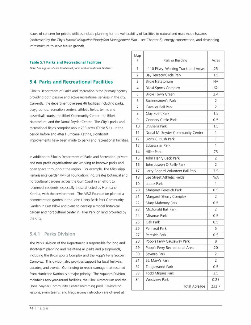
41 | P a g e
Issues of concern for private utilities include planning for the vulnerability of facilities to natural and man-made hazards
(addressed by the City’s Hazard Mitigation/Floodplain Management Plan — see Chapter 8), energy conservation, and developing
infrastructure to serve future growth.
Table 5.1 Parks and Recreational Facilities Note: See Figure 5-5 for location of parks and recreational facilities.
5.4 Parks and Recreational Facilities
Biloxi’s Department of Parks and Recreation is the primary agency
providing both passive and active recreational services in the city.
Currently, the department oversees 46 facilities including parks,
playgrounds, recreation centers, athletic fields, tennis and
basketball courts, the Biloxi Community Center, the Biloxi
Natatorium, and the Donal Snyder Center. The City’s parks and
recreational fields comprise about 233 acres (Table 5.1). In the
period before and after Hurricane Katrina, significant
improvements have been made to parks and recreational facilities.
In addition to Biloxi’s Department of Parks and Recreation, private
and non-profit organizations are working to improve parks and
open space throughout the region. For example, The Mississippi
Renaissance Garden (MRG) Foundation, Inc. creates botanical and
horticultural gardens across the Gulf Coast in an effort to
reconnect residents, especially those affected by Hurricane
Katrina, with the environment. The MRG Foundation planted a
demonstration garden in the John Henry Beck Park Community
Garden in East Biloxi and plans to develop a model botanical
garden and horticultural center in Hiller Park on land provided by
the City.
5.4.1 Parks Division
The Parks Division of the Department is responsible for long and
short-term planning and maintains all parks and playgrounds,
including the Biloxi Sports Complex and the Popp’s Ferry Soccer
Complex. This division also provides support for local festivals,
parades, and events. Continuing to repair damage that resulted
from Hurricane Katrina is a major priority. The Aquatics Division
maintains two year-round facilities, the Biloxi Natatorium and the
Donal Snyder Community Center swimming pool. Swimming
lessons, swim teams, and lifeguarding instruction are offered at
Map # Park or Building Acres
1 I-110 Pkwy. Walking Track and Areas 25
2 Bay Terrace/Circle Park 1.5
3 Biloxi Natatorium NA
4 Biloxi Sports Complex 62
5 Biloxi Town Green 2.4
6 Businessmen’s Park 2
7 Cavalier Ball Park 2
8 Clay Point Park 1.5
9 Connery Circle Park 0.5
10 D’Anella Park 1.5
11 Donal M. Snyder Community Center 1
12 Doris C. Bush Park 1
13 Edgewater Park 1
14 Hiller Park 75
15 John Henry Beck Park 2
16 John Joseph O’Reilly Park 2
17 Larry Bogard Volunteer Ball Park 3.5
18 Lee Street Athletic Fields N/A
19 Lopez Park 1
20 Margaret Peresich Park 0.5
21 Margaret Sherry Complex 2
22 Mary Mahoney Park 0.5
23 McDonald Ball Park 2
24 Miramar Park 0.5
25 Oak Park 0.5
26 Pennzoil Park 5
27 Peresich Park 0.5
28 Popp’s Ferry Causeway Park 8
29 Popp’s Ferry Recreational Area 20
30 Savarro Park 2
31 St. Mary’s Park 2
32 Tanglewood Park 0.5
33 Todd Migues Park 3.5
34 Westview Park 0.25
Total Acreage 232.7
42 | P a g e
the Biloxi Natatorium facility.
5.4.2 Recreation Division
The Recreation Division is based at Hiller Park, in West Biloxi north of Pass Road. Over the last year, public participation in
recreational programs has increased to near pre-Katrina levels. Programs and leagues offered in Biloxi include adult softball,
pewee football, cheerleading, and basketball, and youth softball, baseball, and soccer. The Recreation Division’s planned
improvements for 2008 include providing ongoing repair of facilities damaged by the hurricane, offering a range of recreational
activities for seniors, and increasing programs for those with physical and mental disabilities.
The City’s 1996 Comprehensive Plan examined parks and recreational facilities and recommended acreage by park type (i.e.,
playlot, neighborhood parks, community parks, regional parks, and open space). That Plan identified an overall deficit of 53.5
acres, not including urban greenspace or open space, to adequately serve the City’s population. Figure 5-5 Parks, Libraries, and
Schools shows the location of all parks listed in Table 5.1. As of 2008, the City’s parks and recreational fields comprise about
233 acres, an increase of 70 acres. Further analysis using National Recreation and Parks Association (NRPA) guidelines and the
location of community and neighborhood level parks is necessary to fully assess the community’s parks and recreation needs.
Looking forward, the City should anticipate and plan for recreational trends by proactively identifying the needs of residents. As
part of the public opinion survey conducted for this Comprehensive Plan, residents identified the need for more recreational
programs and facilities for children and the need for more parks, recreation amenities, and open space as two of the most
important aspects of Biloxi’s future. As Biloxi’s population of seniors is expected to grow, the Department is planning to increase
programs and activities for seniors and persons with disabilities. To serve children under the age of 6, the Recreation Division
offers the Start Smart Program at different dates throughout the year. This program helps children ages 3-6 learn the basic skills
of baseball, soccer, and basketball.
Many cities and towns are now looking beyond parks and recreational programming and are planning for open space,
greenways, nature trails, and bike paths. In Biloxi, the popularity of the Biloxi Bay Bridge walking path suggests local interest
and demand for attractive walking paths and trails. The path across the bridge is 10-12-feet wide, spans 1.2 miles from Biloxi to
Ocean Springs, and at its highest point is 95 feet above the water. The shared bike/walkway is separated from the eastbound
travel lanes by a barrier and provides views of Deer Island, the Back Bay, and the Mississippi Sound.
Other than the new Biloxi Bay Bridge path, the walkway under the I-110 underpass, and the County’s Sand Beach, the City lacks
a network of trails, walkways, open space connection, or bikeways for public use. To complement the Biloxi’s existing parks and
recreational facilities and ensure that all needs can be served, the City should consider preparing a parks, recreation, and open
space plan. As part of this plan, an overall open space network would be developed, with a system of connected trails,
greenways, bikeways, and pedestrian links to accommodate increased recreation and transportation choices. The Plan would
also set targets for open space preservation and park needs for future residents.
43 | P a g e
5.4.3 Ports Division
The Parks and Recreation Department also operates the City’s Ports Division. Hurricane Katrina damaged many of Biloxi’s
marinas, docks, and public piers. Most of the damaged facilities are either under construction or will be refurbished at a future
date. The City’s commercial docking facility is located at Beach Boulevard and Lameuse Street, behind the Hard Rock Casino,
and is a popular tourist attraction with fresh seafood sold directly from the boats. Currently the marina accommodates 60 boats
and can hold up to 65 boats. On the Back Bay, the lighthouse fishing docks houses large commercial shrimp boats. There are
about 40-45 regional and local shrimping boats currently accommodated. Representatives of the seafood industry are working
with the City to assure adequate space and unloading facilities needed to help the industry remain in Biloxi and continue to
rebound from Katrina.
The Biloxi Small Craft Harbor, which will house about 132 boats, is currently undergoing repairs and is expected to be
operational in the near future. The redeveloped facility will include new electrical systems installed at higher elevations and a
new bait shop and fuel dock. The Point Cadet Marina has about 265 boat slips for use by private owners, recreational users,
and fishing charter boats. The marina is currently being renovated, with new electrical connections, bathrooms, and structural
repairs necessary after the storm. Figure 5-6 Boating, Fishing, and Water Recreation shows marina facilities and beach parking
locations in the City.
Trends related to the City’s marinas and docks include:
• Over the past 10 — 20 years, boats have become wider requiring berthing slips to be modified to allow larger boats.
• As casinos continue to develop, the demand for boat slips is growing. Casinos are becoming a destination for boats and
the City is seeing more transient traffic in the area. Biloxi is strategically positioned between Texas and Florida and has the
potential to expand its facilities to accommodate increased demand for boat slips.
• The commercial shrimping industry suffered a tremendous blow from Hurricane Katrina. In addition, the high cost of fuel
and high percentage of imported seafood are hurting viability of the industry. The industry has a long history in Biloxi and
there is interest and demand for additional slips which are currently unavailable. Other needs include dedicated,
accessible shrimp processing, ice packing, and refueling facilities to serve commercial fishing boats.
5.5 Public Libraries and Schools
5.5.1 Public Libraries The State of Mississippi’s first free library was founded in 1898 near the Biloxi waterfront. The City now owns the Creole House structure that was home to the state’s first library. Today, the Harrison County Library System operates nine library branch locations in Biloxi, D’Iberville, Gulfport, Pass Christian, and Saucier. There are four branch locations in Biloxi, two of which are operating in temporary structures. The four branches include: the East Biloxi Temporary Library; the West Biloxi Library; the Margaret Sherry Memorial Library in North Biloxi; and the Woolmarket Temporary Library. Biloxi’s downtown library branch, which is located on Lameuse Street, was severely damaged by Hurricane Katrina and is no longer operational. Plans to demolish the downtown branch and build a new structure on Howard Avenue across from the Biloxi Community Center are underway. The West Branch Library recently received $250,000 in grants and FEMA funds to complete building and roof renovations. Services provided by the County’s library system include computer
44 | P a g e
access, reference services and materials, interlibrary loans, and access to the library’s genealogy and local history resources. The Harrison County Library is currently preparing a new strategic plan, which is expected to be completed in April of 2009.
5.5.2 Schools
The City of Biloxi is served by two public school districts. The Biloxi Public School District serves the peninsula and most of North
Biloxi while the Harrison County Public School District serves the rest of North Biloxi and Woolmarket (see Figure 5.5). Public and
private schools are listed in Table 5.2 and illustrated on Figure 5.6.
Biloxi Public School District
The Biloxi Public School District operates 12 schools including seven elementary schools, two middle schools, and the Biloxi High
School. Additionally, the school district manages an alternative school, the Center for New Opportunities, and the Career Tech
Center. The State of Mississippi ranks and assesses schools on an individual basis. Overall the school district was ranked 27 of
145 districts in Mississippi. Nichols Elementary School, located on Division Street in East Biloxi is rated one of the best
elementary schools in the state.17 In 2007, the Biloxi High School was designated one of four “Blue Ribbon Schools” in
Mississippi and one of only 287 in the nation. The Biloxi High School is located in North Biloxi, near the Popp’s Ferry and Cedar
Lake Drive intersection, and currently serves grades 10-12. The District is planning to expand the high school to include 9th
grade, shifting the junior high enrollment and allowing the elementary schools to add pre-kindergarten classes.
One of the major issues facing the school district is the need to determine future enrollment and the possibility of redistricting
schools based on population need. Enrollment in the school district was reduced from 6,125 before Hurricane Katrina to 4,680
at the end of the 2007 school year and then increased to 4,780 at the end of 2008 as a result of families moving back into the
district. Overall enrollment is down about 22% from 2005; however with the construction of Keesler and Biloxi Housing
Authority units, enrollment is expected to rebound in the next few years. The District is assessing the need for a new school
north of the peninsula, as population in that area continues to grow. With tax revenues from casinos and other initiatives, the
Biloxi School District is well funded and positioned to invest in its facilities and continue to provide an excellent education for its
students.
Harrison County Public School District
The Harrison County School District operates 21 schools in unincorporated areas of the County and also within sections of Biloxi,
Saucier, and D’Iberville. Students living in the Woolmarket area of Biloxi attend schools within the Harrison County district,
including Woolmarket Elementary School and North Woolmarket Elementary and Middle School (located about 2 miles north of
the Biloxi municipal boundary).
As Hurricane Katrina recovery continues, enrollment in the Harrison County Public School District is projected to increase from
13,000 to about 14,500 students by the year 2017. About 38% of the growth is projected to occur in the eastern zone of the
17 School Districts are rated by the state each year for accreditation and assessment. Source: www.schooldigger.com
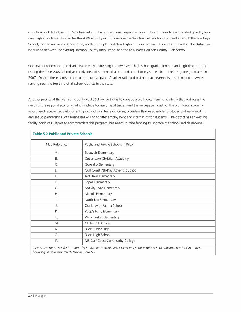
45 | P a g e
County school district, in both Woolmarket and the northern unincorporated areas. To accommodate anticipated growth, two
new high schools are planned for the 2009 school year. Students in the Woolmarket neighborhood will attend D’Iberville High
School, located on Lamey Bridge Road, north of the planned New Highway 67 extension. Students in the rest of the District will
be divided between the existing Harrison County High School and the new West Harrison County High School.
One major concern that the district is currently addressing is a low overall high school graduation rate and high drop-out rate.
During the 2006-2007 school year, only 54% of students that entered school four years earlier in the 9th grade graduated in
2007. Despite these issues, other factors, such as parent/teacher ratio and test score achievements, result in a countywide
ranking near the top third of all school districts in the state.
Another priority of the Harrison County Public School District is to develop a workforce training academy that addresses the
needs of the regional economy, which include tourism, metal trades, and the aerospace industry. The workforce academy
would teach specialized skills, offer high school workforce diplomas, provide a flexible schedule for students already working,
and set up partnerships with businesses willing to offer employment and internships for students. The district has an existing
facility north of Gulfport to accommodate this program, but needs to raise funding to upgrade the school and classrooms.
Table 5.2 Public and Private Schools
Map Reference Public and Private Schools in Biloxi A. Beauvoir Elementary
B. Cedar Lake Christian Academy
C. Gorenflo Elementary
D. Gulf Coast 7th-Day Adventist School
E. Jeff Davis Elementary
F. Lopez Elementary
G. Nativity BVM Elementary
H. Nichols Elementary
I. North Bay Elementary
J. Our Lady of Fatima School
K. Popp’s Ferry Elementary
L. Woolmarket Elementary
M. Michel 7th Grade
N. Biloxi Junior High
O. Biloxi High School
P. MS Gulf Coast Community College
(Notes: See Figure 5.5 for location of schools; North Woolmarket Elementary and Middle School is located north of the City’s boundary in unincorporated Harrison County.)
46 | P a g e
6. Demographics and Housing
Key Findings
• Biloxi’s population is growing older. Since the 1990 census, the percentage of population over the age of 65 has
increased. The median age of residents increased from 28.6 in 1990 to an estimated 35 years old in 2007.
• As the population grows older, the percentage of residents in the 20 to 34 year old age groups is decreasing. In
fact, between 1990 and 2000, all age groups under the age of 34 lost population, while the number of persons in
the 35 and older groups increased.
• The City’s unemployment rate rebounded from 25% the month after Hurricane Katrina to 6.2% in 2007. In June
of 2008, the unemployment rate had increased to 7.2% based on Mississippi Employment Security Commission
data.
• In Biloxi, a high percentage of the population has an associate degree (16% in Biloxi compared with 7% in the
state and nationally). Overall, in both Biloxi and Harrison County, about 20% of the population over the age of 25
has either a bachelor’s or graduate degree, which is higher than the state average of 17%, but lower than the
national average of 27% (see Table 6.3).
• The number of housing units is projected to increase by about 6.5% through 2012. Housing vacancy, also
projected to increase, is based on 2007 estimates, which highlight high post-Katrina vacancy rates. Although one
source projects that vacancy will increase through 2012, other factors not represented in the projection (e.g.,
residents moving back to Biloxi, sale or demolition of vacant homes, and permitted condos that are not constructed)
may cause the percentage of vacant homes to decrease, rather than increase, in coming years.
• While the number of renter-occupied units increased, their overall percentage decreased from 47% in 1990 to
45% in 2000. However, this figure is still relatively high. Vacancy among rental units (5.5%) is much lower than
the overall vacancy rate (18%).
• Approximately 80% of the housing stock in East Biloxi was either destroyed or uninhabitable following Hurricane
Katrina. Since that time rebuilding has occurred at a slow pace. Obstacles to redevelopment include the high
number of rental units that were destroyed by the storm, the high cost of flood and wind insurance, financing and
construction costs, speculative land prices, and small lot sizes.
• There is a growing shortage of affordable housing options in the region. As FEMA trailers, MEMA Mississippi
Cottages, and funding expire, more residents will be without affordable housing options. Housing options are
essential if the City is to be competitive in the regional economy and attract new residents.
• The overall poverty rate, as defined by the U.S. Census, for Harrison County in 2004 was 11%. This rate increased
to 14% in 2007. The 2007 rate is lower than the state’s average of 21%, but is higher than the U.S. average of
13%. Poverty rates are higher among children and single-parent households than in the overall population.
• There are many organizations (e.g., Gulf Coast Renaissance Corp., Biloxi Housing Authority, Back Bay Mission,
Habitat for Humanity, East Biloxi Recovery Center, and others) collaborating to address housing issues such as
homelessness, rebuilding, public transit, and social services.
47 | P a g e
• In the aftermath of Katrina, about 700 of the 900 Biloxi Housing Authority (BHA) units were destroyed or
uninhabitable. Currently, there is a waiting list for Section 8 units and BHA owned properties. In May of 2008,
redeveloped and occupied units were up to about 600 units.
• The Biloxi Housing Authority recently completed its five-year plan. Major goals of the plan include: creating 1,500
new housing units, developing mixed-income and mixed-use neighborhoods, reducing crime/creating livable
neighborhoods, and creating a land bank to assemble available land for future projects.
• Linked to poverty and affordable housing, homelessness is an increasing problem in the region. Hurricane Katrina
damaged or destroyed many of Biloxi’s most affordable and rental housing units. Organizations such as the Back
Bay Mission are working to raise public awareness, improve acceptance of affordable housing, and find solutions in
the region.
6.1 Demographic Characteristics
The following overview of demographic conditions and trends in Biloxi provides background and context for issues discussed in
earlier sections of this report.
With a few exceptions, population in Biloxi has been growing since the 1870s. The biggest increase occurred between 1940 and
1950 (+114%), coinciding with the arrival of Keesler Air Force Base. Population declined in the 1980s (-6%) but grew
substantially the following decade with the introduction of dockside casinos in 1992. The City continued to grow until 2005,
when Hurricane Katrina devastated the City’s population and housing stock. Following the storm, Biloxi’s population decreased
from 50,614 to 44,292.
Table 6.1 shows population change in Biloxi between 1980 and the 2012 population estimate. It is important to note that
population before 2000 did not include the Woolmarket area which was annexed in 1999. The 2012 projection estimates a
conservative 0.5% increase between 2007 and 201218. A number of near-term projects, such as the expansion of Keesler’s Air
Force housing and Biloxi Housing Authority units, may increase population at a faster rate than projected. Tables 6.2 through
6.4 provide a snapshot of demographics, income, and poverty levels in 2007.
As Biloxi’s population continues to rebound from Hurricane Katrina, key trends include:
• The average household size decreased from 2.42 in 2000 to 2.38 in 2006. This decrease is typical of national trends
which continue to shift away from traditional households to smaller, more diverse household types.
• Biloxi’s population is growing more racially and ethnically diverse. The City’s Hispanic population grew by 38% between
1990 and 2000. The percentage of population identifying themselves as Black, Asian, some other race, or two or more
races, is expected to increase from 2007 to 2012.
• Demographic characteristics in Biloxi, such as median age, income, and educational attainment, are very similar to the
characteristics of Harrison County.
18 Decision Data Resource Estimates (2007).
48 | P a g e
• Biloxi’s population is growing older. Since the 1990 census, the percentage of population over the age of 65 has been
gradually increasing. The greatest percent change between 2007 and 2012 is projected to be in residents over the age of
55.
• As the City’s residents are growing older, population in age groups between 20-34 is decreasing. In fact, between 1990
and 2000, the percentage of population in age groups under the age of 34 decreased, while the 35 and older groups
increased.
• In 2007, according to the American Community Census Survey, 14% of population in Harrison County and 14.2% of
population in the Gulfport-Biloxi MSA is below poverty level, an increase from 11% in 2004. These poverty rates are
lower than the state’s average of 20.6%, but higher than national rate of 13% (see Table 6.4). Poverty rates are higher
among children and single-parent households than in the overall population.
6.2 Housing Characteristics
An important factor for Biloxi’s future and post-Katrina recovery is the quality, location, and cost of its housing and the livability
of its neighborhoods. As discussed in Section 3.1, over 20% of the City’s housing and business were severely damaged or
destroyed in 2005. In East Biloxi, approximately 80% of the housing stock was either destroyed or uninhabitable. While residents
are returning and rebuilding homes and new development is occurring, in East Biloxi redevelopment is occurring at a slower pace.
Table 6.5 summarizes the change in housing units from 1990 to the projected number of units in 2012.
The following summarizes general issues related to housing in Biloxi:
• Given hurricane damage, it is not surprising that the number of vacant units in 2007 is nearly double the 2000 total. The
increase in vacancy is forecasted by one source to continue into 2012. However, other factors not represented in the
projection (e.g., residents moving back to Biloxi, sale or demolition of vacant homes, and permitted condo units that are
not constructed) may cause the percentage of vacant homes to decrease, rather than increase, in coming years.
• The percentage of owner-occupied housing increased between 1990 and 2000, but was still less than the number of
rental units. Between 2000 and 2007 (post-Katrina) the number of owner-occupied units decreased while the renter-
occupied units increased. The City’s Community Development Department expects the number of single-family permits to
increase, as a result of demand and continuing infrastructure improvements. This projection may increase, rather than
decrease, home-ownership rates in the coming years.
• The issue of housing cost and affordability is one of the principal housing-related challenges facing Biloxi. The average
sales price for a home on the Mississippi Gulf Coast (Harrison, Hancock, and Jackson Counties) was about $162,300 in
June of 2008 and averaged $166,600 in 2007, according to the Mississippi Gulf MLS. The average sales price in the
region is nearly four times the median household income ($41,542) of the Gulfport-Biloxi MSA. In 2004, the average
sales price was $129,800 in the three counties.
• Through the City’s Homeownership Assistance Program, down-payment assistance up to $30,000 is available for
qualified applicants. The program has been successful in offering financial support; however, even with assistance,
high land prices and flood insurance costs are preventing many residents from returning to the peninsula.
• The Gulf Coast Renaissance Corporation recently announced the creation of REACH (Regional Employer Assisted
Collaboration for Housing) to further help those living in the Mississippi Coast area buy their own homes. The
program provides gap financing directly to individuals or families earning less than 120 percent of the area median
income through federal assistance and employer contribution. Under REACH, participating employers contribute
49 | P a g e
between $5,000 and $10,000 with up to tripled matching funds available from the Gulf Coast Renaissance
Corporation. A repayment plan is determined, with some funds typically forgivable over a period of employment.
• The 2007 Mississippi Gulf Coast Apartment Survey counted a total of 4,950 market rate rental units in Biloxi with a
vacancy rate of 5.5% at the time of the survey. Average monthly rents in the City range from $667 for a one-bedroom
apartment to $780 for a 2-bedroom, and $950 for a three bedroom. Market rate rentals for each of these unit types
increased by 29 to 44% between October 2004 and March 2007. In the three coastal county area, the vacancy rate
among assisted (below market-rate) apartments was 0.1%, significantly lower than the overall vacancy rate.
• The cost of living in the Biloxi area is increasing, but remains below the national average. According to the Council for
Community and Economic Research, in 2007, cost of living in the Biloxi MSA was 97.3% of the US average, up from 95%
in 2003.
• In 2005, about 68% of housing units in the Gulfport-Biloxi MSA were single-family detached. Another 13.8% were
mobile homes and 6.4% were structures with more than 10 units. The smallest percentage of housing type (1.7%)
was the 2-unit buildings.
6.3 Biloxi Housing Authority
The mission of the Biloxi Housing Authority (BHA) is to provide safe and affordable housing for middle to lower income residents
of Biloxi and improve quality of life, housing, and services for residents. The BHA partners with the City of Biloxi, civic
organizations, non-profits, local businesses, and banks and is active in the development, construction, and ownership of
affordable, senior, and market rate housing.
One successful partnership between the BHA and the Gulf Coast Housing Partnership, a New Orleans-based nonprofit
development company, has led to three completed projects and one in development. The projects are:
• Cadet Point (76-unit senior facility completed);
• Bayview Place (196 new and rehabbed apartments completed);
• Bayview Oaks (39 single-family homes completed); and
• East End Homes (34 new apartments in pre-development phase).
6.3.1 Impact of Hurricane Katrina
Following Hurricane Katrina, about 700 of the 900 Biloxi Housing Authority units were destroyed or uninhabitable. Today, the
process of rebuilding is well underway. In May of 2008, the BHA had about 600 occupied units (2/3 of the pre-Katrina total). A
major HOPE VI redevelopment project, Bayview Bayou Auguste, has been completed. The development features a mix of rental
units, senior units, mixed-income housing, multi-family housing, and homeownership units. New homes within the development
are designed to be part of a livable, walkable community with sidewalks, tree-lined streets, front porches, rear garages with
alleys, and access to neighborhood parks.
50 | P a g e
6.3.2 Major Issues and Goals
Despite progress made in rebuilding units, there is still a waiting list for Section 8 units and Housing Authority owned properties
in Biloxi. The need for affordable “workforce” housing (apartments and rental houses costing less than $800 a month and
homes that can be purchased for less than $185,000)19 continues to increase in the City and the larger region.
In 2007, the Biloxi Housing Authority presented a 5-year plan and continued commitment to affordable housing for families and
seniors and reducing concentrations of poverty. The BHA is also considering creating a land bank to assemble land for future
projects. Major goals of the BHA 5-year plan include:
• Create 1,500 new housing units;
• Develop mixed income and mixed-use neighborhoods; and
• Reduce crime and create livable neighborhoods.
6.4 Other Social Service/Housing Agencies
6.4.1 Back Bay Mission
Founded in 1922, the Back Bay Mission is a faith-based organization with a broad range of services. The Mission’s programming
has expanded over the years and now includes:
• The Center for Community Ministry;
• Community Development and Social Change;
• Mission Education;
• Disaster Relief / Recovery (“Workcamping” for volunteer teams from around the country);
• Emergency Assistance;
• Home at Last; and
• Affordable Housing.
Through the Emergency Assistance, Home at Last, and Affordable Housing programs, the Back Bay Mission provides financial
assistance for rent/mortgage/utility relief, prescription drugs and transportation. The Mission also offers information/referrals,
case management services, and permanent housing/support services for homeless and disabled persons. The Back Bay Mission is
partnering with other housing agencies to resolve the shortage of affordable housing for low-income residents in the region. As
a result of Hurricane Katrina, the Mission is now expanding its services to include housing rehabilitation and reconstruction. The
Mission has partnered with the City of Biloxi in the past and received grants from both Biloxi and Gulfport to restore homes for
homeowners in need of financial resources.
19 Defined by the Sun Herald Housing Editorial Board (July 2008).
51 | P a g e
6.4.2 Open Doors Homeless Coalition
Open Doors Homeless Coalition (ODHC) works throughout South Mississippi to confront the needs of persons and families
experiencing homelessness and supports permanent and transitional housing. The Coalition reports growth in the number of
persons experiencing homelessness. Escalating housing prices, loss of affordable housing units from Katrina, and growth of low
wage service jobs are factors noted by the Coalition as contributing to homelessness in the region. According to market analysis
reports prepared by the U.S. Department of Housing and Urban Development in 2006, more than half of the units damaged or
destroyed by the storm were occupied by households earning less than half of the median family income.
Since its inception, the Coalition has worked with the City of Biloxi to develop a 10-year plan to combat homelessness with the
Biloxi Housing Authority to establish housing, and has received HUD grants with member agencies to develop permanent
supportive housing. ODHC is continuing its mission to combat homelessness through the use of HUD grants for supportive
housing and services.
7. Economic and Employment Analysis
Key Findings
• Biloxi’s unemployment rates from 2000 to 2008 indicate that the City’s economy appears to still be adjusting from
the losses caused by Hurricane Katrina in 2005. Unemployment rates should steadily drop back to pre-2005 levels
as the regional economy rebuilds.
• Most of Biloxi’s employment is in the nonmanufacturing sectors, the regional economy is continuing its recovery to
its pre-Katrina levels of 2004, and its strongest sectors are hospitality, government and retail. (It should be noted
that the large employment increases in construction and waste management sectors are likely related to the post-
Katrina reconstruction efforts and will not be sustained in the long-term.)
• Four of Biloxi’s top employers are government and/or institutional services. Keesler Air Force Base is the largest
employer in the City, and Biloxi’s Regional Medical Center and Public School District (the fifth and sixth top
employers) provide high quality healthcare and educational services that benefit Biloxi’s residents, businesses and
visitors. The City of Biloxi is currently the 9th largest employer in the City.
• The projected increase in the housing vacancy rate raises some concern regarding the future housing supply. The
vacancy rate is projected to increase based on 2007 data, which highlights high vacancy following Hurricane
Katrina. Other factors, such as a slower absorption rate for condos and recovery from Hurricane Katrina, may
result in a lower overall vacancy rate than projected. In addition, the average sales price for single-family and
condominiums has been steadily increasing and was $183,498 in July 2007.
• Biloxi’s constrained rental market and steadily increasing prices of for-sale properties creates a housing affordability
issue for the City’s residents.
• The retail sector in Biloxi has returned to it pre-Katrina levels.
52 | P a g e
• Biloxi is not a major manufacturing center. However, the seafood industry has a long history in the City and major
aerospace and shipbuilding operations are located in the larger region.
• The key to Biloxi’s future growth as a premier tourism destination will be continued investment in transportation
infrastructure, new resorts, and expanded entertainment/recreation options.
• Biloxi’s casinos are continuing to recover from the damages caused by Katrina, with approximately 74% of its hotel
inventory in operation at this time. But the industry appears likely to achieve and build on the premier regional
destination status it achieved prior to Katrina.
• The Innovation Center, formerly the Gulf Coast Business Technology Center, acts as an incubator for start-up
companies by offering business services, office and light manufacturing rental space, shared conference facilities,
counseling, and workshops. The Innovation Center provides a central location where entrepreneurs can
research new business ideas, attend workshops, receive counselling, and use no-cost business plan and website
related software.
• The Gulf Coast branch of the Mississippi Small Business Development Center is located at the Innovation Center
and offers business counseling, start-up assistance, and workshops for entrepreneurs.
7.1 Employment
The condition of a region’s labor force is an important indicator of the health of its economy. The City of Biloxi had a labor force of 21,650 workers in July of 2008 and its unemployment rate was 7.5 percent. Biloxi is performing better than Mississippi in providing jobs, but its unemployment rate is slightly higher than the Biloxi-Gulfport MSA’s 6.8 percent. Biloxi’s unemployment rates from 2000 to 2008 indicate that the City’s economy appears to still be adjusting from the losses caused by Hurricane Katrina in 2005. Unemployment rates should steadily drop back to pre-2005 levels as the regional economy rebuilds. Biloxi’s labor force appears to be growing moderately with a rate of change of 1.2 % from 2007 to 2008. The City’s per capita income is also positive at $36,390 in 2007 when compared with the U.S per capita income in 2007 of $26,804.20
Another important consideration in assessing a community’s labor force is what types of employment are available in the region
and what is the future outlook for employers. Table 7.3 lists Biloxi’s top employers in 2007. It is significant that all of the City’s
top employers are related to the gaming industry or government/institutional services. The comparison to the Biloxi-Gulfport
MSA Employment sectors in Table 7.4 shows that both the City and the MSA are highly oriented toward the service economy.
The employment activity of various economic sectors by establishment in the Biloxi area is detailed in Table 7.5. This historical
perspective from 2004 to 2008 confirms the trends previously stated that most employment is in the nonmanufacturing sectors,
the regional economy is continuing its recovery to its pre-Katrina levels of 2004, and its strongest sectors are hospitality,
government and retail. It should be noted that the large employment increases in construction and waste management sectors
are likely related to the post-Katrina reconstruction efforts and will not be sustained in the long-term.
20 2007 American Community Survey (US Census)
53 | P a g e
7.2 Economic Sectors
Biloxi’s economy is both diverse and resilient. This section provides an overview of the City’s major economic sectors and the
trends impacting them.
7.2.1 Housing Sector
The housing information included in Chapter 6 shows that the estimated number of housing units in 2007 is 24,647 and is
projected 26,233 units in 2012.21 While the City has issued about 1,500 residential permits since Katrina, only 420 or so have
resulted in new homes. The cost of flood and wind insurance, construction costs, and higher elevations are impacting the pace
of residential building and expansion. Residential permit activity since 2004 is shown in Table 7.6.
The projected increase in the housing vacancy rate raises some concern regarding the future housing supply. The vacancy rate
from 2007 to 2012 is projected to be 27.1%.22 Other factors, such as a slower absorption rate for condos and recovery from
Hurricane Katrina, may result in a lower overall vacancy rate than projected in 2012. In addition, the average sales price for
single-family and condominiums has been steadily increasing and was $183,498 in July 2007.23 Also, recently Biloxi was ranked
first in Housing Predictor’s Top 25 Appreciating U.S. Markets. Given the very moderate population growth projected for Biloxi, it
appears the housing projections are optimistic and should be carefully monitored.
The supply of multi-family, rental housing currently appears constrained. The average rental rate for a 3-bedroom apartment in
Biloxi was $950.89, a 29.3% increase from 2004. Also, Biloxi’s apartment vacancy rate of 5.5% in 2007 has generally been
lower than most surrounding communities.24
The constrained rental market and steadily increasing prices for-sale properties creates a housing affordability issue for the City’s
residents. This is especially a concern for the service and construction workers attracted to Biloxi. The Biloxi Housing Authority
and the Mississippi Home Corporation are both seeking to address this issue through direct construction of affordable units and
tax credits to private developers to supply these types of units.
7.2.2 Commercial Sector
Biloxi is currently experiencing a high level of commercial investment. From 2005 through 2007 commercial development in the
City was valued at over $476 million. Much of this investment can be attributed to rebuilding efforts following Katrina, but new
business startups are also positive with 279 new business licenses issued by the end of 2006.25
21 Decision Data Resources (2007 Estimates). 22 Decision Data Resources (2007 Estimates) 23 Mississippi Gulf Coast Multiple Listing Service (MLS) 24 W.S. Loper and Associates, MS Gulf Coast Apartment Surveys 25 City of Biloxi Licensing Division
54 | P a g e
The retail sector in Biloxi has returned to it pre-Katrina levels. In 2002 the city had 1,353 retail establishments and by in the end
of 2006 the number was 1,367. Also, retail sales remain strong with $791 million in sales in 2006, and these figures do not
include the retail activity located in Biloxi’s casino resorts.26
Biloxi’s commercial activity is distributed in various locations throughout the City. Edgewater Mall, the Mississippi Coast’s largest
enclosed mall, and the surrounding area received major investment. Approximately $15.5 million has been spent by Dillard’s,
one of the Mall’s four major department stores, to rebuild its anchor store. Also, the new 200,000 square foot Edgewater
Village shopping center opened last year. The City’s infrastructure investment has encouraged additional commercial
development along the Popp’s Ferry — Cedar Lake corridors, Pass Road, Caillavet Street, Main Street, Howard Avenue, U.S.
Highway 90 in downtown Biloxi, the Convention Center area, and Woolmarket.27
7.2.3 Industrial Sector
Biloxi is not a major manufacturing center as indicated by the employment figures in Section 7.1. However, the seafood industry
has a long history in the City of Biloxi and major aerospace and shipbuilding operations are located in the larger region.
Aerospace Industry
The Biloxi area has one of the largest concentrations of avionics and aircraft maintenance personnel in the U.S..28 A large
number of these personnel are employed by the NASA Stennis Space Center.
The John C. Stennis Space Center, located about 50 miles west of Biloxi in Hancock County, is one of the ten NASA field centers
in the United States. Stennis is the largest rocket engine test complex in the U.S., providing propulsion test services for NASA,
the Department of Defense, and the private sector. In late 2010 the Stennis Center will begin assembling and testing and the
next generation of engines for the Orion spacecraft.
The Center is home to more than 30 federal, state, academic, and private technology-based organizations. Sharing facility costs
and resources across organizations is cost-effective for the individual organizations and encourages partnerships. Organizations
located at the Stennis Space Center include:
• Naval Meteorology and Oceanography Command;
• Naval Research Laboratory;
• Department of Defense’s Navy Special Boat Team 22 and the Naval Small Craft Instruction and Technical Training School;
• Lockheed Martin’s Mississippi Space and Technology Center;
• University of Southern Mississippi’s High Performance Visualization Center;
• Rolls Royce North America (Outdoor Jet Engine Testing); and
26 Mississippi State Tax Commission 27 Biloxi General Market Analysis (2008) 28 Biloxi General Market Analysis (2008)

55 | P a g e
• US Geological Survey Hydrologic Instrumentation Facility.
NASA employs about 2,200 of the nearly 5,000 employees at the Stennis Center. More than one-third of the total employees at
the Center are scientists or engineers. The other aviation facilities in the Biloxi region are government operations, which are
discussed under the Government/Institutional sector below.
Shipbuilding Industry
Shipbuilding in the Biloxi region includes military ships, offshore industry ships, and private yacht construction. The major
shipbuilding facilities include:
• Northrop Grumman;
• VT-Halter Marine;
• Rolls-Royce Naval Marine;
• Signal International;
• Trinity Yachts; and
• Gulf Ships.
Northrop Grumman owns the Ingalls shipyard in Pascagoula and is Mississippi’s largest employer with more than 10,000 workers. The shipbuilding industry’s future in the greater Biloxi region looks bright as Southern Mississippi is striving to be a leading center for materials research in the shipbuilding industry and has taken an important step to achieve this goal with the creation of a marine composites consortium.29
Seafood Industry
The seafood industry continues to play an important role in Biloxi’s economy and culture. There is no data on the industry
specifically for the City of Biloxi, but in 2003 Mississippi State University conducted an economic impact analysis of the seafood
industry on the Mississippi Gulf coast in Hancock, Harrison, and Jackson Counties.30 The analysis found that the industry had a
total economic impact of over $900 million dollars, employed more than 16,800 workers, and generated over $42 million in
indirect business taxes. It is likely that Biloxi’s share is over one-third of the total economic impact, which verifies the economic
importance of this industry to its economic base. It is also a unique local attraction for tourists visiting Biloxi.
Because there is no seafood industry data specifically for Biloxi, damage estimates for Katrina are not available. Professor
Posadas at Mississippi State University conducted a seafood industry survey on the Gulf Coast in 2005 to assess the damages to
the industry and found that total damages to the commercial and recreational seafood industry property and inventory were
estimated at $123 million. Also, Richard Gollott, a Commissioner of the Mississippi Department of Marine Resources and owner
of Golden Gulf Coast Seafood in Biloxi, reported that the number of licensed shrimp boats has been down 50 percent following
Katrina, and only 4 processing plants are currently operating in Biloxi compared to 11 plants prior to the storm.
29 Biloxi General Market Analysis (2008) 30 Professor B. Posadas, Ph D at Mississippi State University, 2003.

56 | P a g e
Seafood representatives have confirmed the economic significance of the industry for Biloxi, particularly the shrimp industry.
Biloxi’s shrimp industry is reported to be the most valuable fishery in the U.S. In addition, shrimp fishermen have historic ties to
Biloxi and many would like to continue operating in the City. Current threats to the sustainability of the local seafood industry
include new commercial development, the need for critical processing and operations facilities on the waterfront, and
inexpensive foreign competition. According to the Southern Shrimp Alliance, about 90 percent of the shrimp consumed in the
U.S. is imported from Asia and South America. Wild American Shrimp, the marketing arm of the Southern Shrimp Alliance, is
one organization focusing on this U.S. marketing effort and country of origin labeling.
7.2.4 Tourism
The Biloxi area has historically been an affordable vacation destination. Since the 1990’s, the major attraction for tourism has
been casino gaming. But the region offers a beachfront location and other recreation amenities, which are bringing visitors from
greater distances and supporting Biloxi’s efforts to be a premier destination. These attractions include:
• The Mississippi Coast Coliseum & Convention Center. This is the largest beachfront facility of its type in the South.
Conferences, trade shows, and major sporting and recreation events are held at the Coliseum and Convention Center. It
is also the home of the Mississippi Sea Wolfs Professional Hockey Team.
• Golf Courses. The Mississippi Gulf Coast Golf Association estimated a $50 million local economic impact before
Hurricane Katrina from 16 golf courses in the area.
• Fishing and Water Sports. The natural diversity created from the blending of fresh and salt water along the Gulf Coast
creates many opportunities for fishing and water recreation. The region has been named a top 20 worldwide fishing
destination by Saltwater Sportsman magazine.
• Major Recreation Events. Biloxi hosts a growing number of regional and national events for a variety of recreational
interests, including: Cruisin’ the Coast, Smokin’ the Sound, the Mississippi Gulf Coast Billfish Classic, the Southern
Kingfish National Championship, and various tennis and golf tournaments.
• Cultural and Leisure Amenities. New restaurants, shops, the Ohr-0’Keefe Museum of Art, the Maritime and Seafood
Industry Museum, and spa facilities are drawing visitors to Biloxi. The Spa at Beau Rivage was recognized as one of the
top 25 spas in the U.S. in 2007 by Travel and Leisure magazine.
Biloxi’s core tourism market is still a drive-in market from the entire Gulf coast from New Orleans to Florida. A Mississippi Gulf
Coast Visitor Profile completed in 2005 identified Biloxi’s visitor profile shown in Table 7.8.31 It should be noted that Biloxi’s
typical visitors are more likely to be retired and have a lower average household income when compared with other Gulf coast
visitors. It also showed that 87 percent of visitors planned to gamble during their trip, 40 percent of visitors identified shopping,
and nearly 25 percent identified sightseeing as secondary reasons for visiting Biloxi. The Visitor Profile additionally found that
travelers classified as “venturers” who are traveling from further away, are younger than 50, have more formal education, earn
more annually, and are more likely to visit for reasons other than gambling are more attracted to Biloxi compared to other Gulf
31 Mississippi Gulf Coast Visitor Profile prepared by TNS for the Mississippi Gulf Coast Convention and Visitors Bureau, 2005 - 2nd Quarter Report
57 | P a g e
coast locations. Biloxi’s major road improvements and the expansion of the Gulfport-Biloxi International Airport have also
contributed significantly to travelers from a larger geographic area visiting Biloxi.
Hotel accommodations in Biloxi are important to address to maintain its tourism industry. The hotel room supply has been
constrained by the damage to facilities caused by Katrina. Currently, only two-thirds of Biloxi’s hotel supply is in operation.32
But it appears that the City’s casino and hotel operators have the capacity and resources necessary to fully recover and expand
into new lodging and resort options.
The key to Biloxi’s future growth as a premier destination will be continued investment in transportation infrastructure, new resorts, and expanded entertainment/recreation options.
Gaming Industry
The casino gaming industry is a major employer and revenue source for the City of Biloxi. Over 10,000 workers are employed by the gaming industry in the City, and approximately 16 million people visit the casinos annually.33 Eight casinos are currently located in Biloxi, including:
• Beau Rivage Resort & Casino;
• Boomtown Casino;
• Grand Biloxi Casino Hotel & Spa;
• Hard Rock Hotel & Casino;
• IP Casino Resort Spa;
• Isle of Capri Casino Resort;
• Palace Casino Resort; and
• Treasure Bay Casino & Hotel.
New casino facilities are currently being planned. The Bacaran Bay Casino Resort is a $500 million development schedule to
open in 2009. The Bayview Casino Resort has been approved on Biloxi’s Back Bay.34 Also, the $704 million project of Harrah’s
Margaritaville Casino & Resort is now under construction and is expected to be completed in 2010.35
Biloxi’s casino’s are continuing to recover from the damages caused by Katrina, with only approximately 74% of its hotel
inventory in operation at this time.36 But the industry appears likely to achieve and build on the super regional destination status
it achieved prior to Katrina. This projection is based on new state laws for land-based casino development and the fact that the
32 Mississippi Hotel & Lodging Association: Hotel Inventory — Post Katrina, Gulf Coast Region — Hancock, Harrison & Jackson Counties, August 2008. 33 Biloxi General Market Analysis (2008) 34 Biloxi General Market Analysis (2008) 35 www.gulfcoast.org 36 Mississippi Hotel & Lodging Association: Hotel Inventory — Post Katrina, Gulf Coast Region — Hancock, Harrison & Jackson Counties, August 2008.
58 | P a g e
City’s major casino operators seem to have the resources and capacity to create major destination resorts. A conservative
scenario for Biloxi’s casinos in the next few years is a projection of 12 casinos, built on 300 acres, employing approximately
16,000 people, with $1.4 billion in revenues. A more aggressive scenario projects 17 casinos on 600 acres with 25,000
employees.37
Convention and Meeting Industry
Biloxi’s convention business is building and diversifying Biloxi’s larger tourism industry. The Mississippi Coast Coliseum &
Convention Center in Biloxi currently provides 180,000 square feet of meeting space and is expanding to 400,000 square feet in
2009.38 The Harrah’s Margaritaville Casino & Resort, currently under construction, will also include 66,000 square feet of
meeting space.39
7.2.5 Government & Institutional Sector
Table 7.3 notes that four of the City’s top employers are government and/or institutional services. This sector is not only a major
component of Biloxi’s economic base; its facilities and jobs support the overall quality of life in Biloxi. Keesler Air Force Base is
the largest employer in the City, and Biloxi’s Regional Medical Center and Public School District (the fifth and sixth top employers)
provide the high quality healthcare and educational services that benefit Biloxi’s residents, businesses and visitors. This sector of
Biloxi’s economy is stable, with only moderate growth expected proportional to anticipated population growth.
Keesler Air Force Base
Located on Biloxi’s peninsula, the Keesler Air Force Base employs 11,200 people, including nearly 6,900 military personnel.
Additionally, the Keesler Air Force Base supports nearly 3,500 local and contract jobs. Keesler’s total economic impact for fiscal
year 2007 was calculated at over 1.1 billion dollars. The base has an important national presence as a major Air Force training
center and is home to the second largest medical center in the U.S. Air Force (see description of the Keesler Medical Center in
Chapter 5). In addition, the 53rd Weather Reconnaissance Squadron, known as the “Hurricane Hunters” of the Air Force
Reserve, are based at Keesler AFB. The “Hurricane Hunters” is the only organization of its kind that still flies directly into storms
to provide the National Hurricane Center with exact locations, wind speed data, and pressure readings.
The Keesler Air Force Base opened its doors in Biloxi in 1941 and quickly grew to include a technical training center and basic
training center. Today, its students train in communications-electronics, medical, personnel, airfield management, weather
forecasting, air traffic control, and medical specialties. The Base was badly damaged in Hurricane Katrina, but is well on its way
to recovery through rebuilding.
37 Biloxi Gaming Market Potential , Economic Research Associates, May 2006 38 www.mscoastcoliseum.com 39 www.gulfcoast.org
59 | P a g e
Other Federal Centers
There is a strong military presence in the Biloxi-Gulfport metro area. In addition to the Keesler Air Force Base in Biloxi, the Naval
Construction Battalion Center in Gulfport is home to the Atlantic Fleet’s Seabees. The Battalion is responsible for construction of
buildings and roads in wartime and emergency repairs following hurricanes and other natural disasters. The approximately
1,100-acre navy industrial complex has a deep water port and employs over 4,500 people on the base.
The Mississippi Air National Guard in Gulfport is home to the 255th Air Control Squadron and the 209th Civil Engineering
Squadron. The two squadrons are involved in a wide range of activities, including flight operations, radar surveillance, and
emergency preparedness. The Guard’s Combat Readiness Training Center was developed at the Gulfport-Biloxi International
Airport in 1953. Today more than 20,000 Air Guard and Reserve flight personnel are trained at the base annually.
NASA’s John C. Stennis Space Center is also located in the Biloxi region. More than 20 federal and state agencies are part of the
Stennis Space Center, which employs more than 30,000 military and civilian personnel. (See description of the Stennis Space
Center in the Aerospace Industry Section of this Chapter.)
The Innovation Center
Since 1990 the Innovation Center (formerly the Gulf Coast Business Technology Center) has provided office and light
manufacturing space, business services, and mentoring for small start-up companies. The Innovation Center acts as an incubator
for small businesses by offering rental space, shared conference facilities, business planning assistance, consulting, seminars,
workshops, telecommunications, office equipment, administrative services, and computers at a low cost.
The Center also offers a Virtual Tenant Program, which provides entrepreneurs support and resources without renting an office
space. In addition, the Center operates a small computer center, free and open to the public, which provides access to business
software and website related resources.
The Innovation Center currently provides tenant facilities for about 30 businesses and has graduated over 60 local businesses,
creating hundreds of jobs in the region, since its inception. The Center is located near the Cedar Lake and Popp’s Ferry Road
intersection in North Biloxi.
Mississippi Small Business Development Center
Located at the Innovation Center in Biloxi, the University of Mississippi Gulf Coast branch of the Mississippi Small Business
Development Center offers business counseling, start-up assistance, and classes in business basics and financing. Additional
resources include business plan development, market analysis, capital sources, technology transfer, federal grant information,
and managerial and technical support services.
The Gulf Coast Small Business Development Center serves the southernmost six counties in Mississippi. The Center is a partnership between the Small Business Administration (SBA), the Mississippi Legislature, and the University of Mississippi.
60 | P a g e
8. Previous Plans
The City of Biloxi’s current Comprehensive Plan was adopted in 1996. Given the significant changes that have occurred since
that time, it is obvious that a new comprehensive plan is needed to set the direction for the City’s future in the 21st century.
Because a number of plans have been prepared since the 1996 Comprehensive Plan — particularly in the last several years in
response to the need for recovery and rebuilding after Hurricane Katrina — this effort does not need to start from scratch. Rather,
it should incorporate and build on the best aspects of previous planning initiatives, many of which have involved extensive public
input. In so doing, the comprehensive planning process will ask and answer a key question:
How do these initiatives fit together and how can they be integrated into a framework providing a unified vision and
plan for the future of Biloxi?
To provide a basis for addressing this question, this section summarizes selected previous plans that are relevant to the current
comprehensive planning effort. These plans include:
• Vision 2020 Comprehensive Plan (1996)
• Mississippi Gulf Coast National Heritage Area Management Plan (2005)
• A Reconstruction Plan for Biloxi, MS (November 2005)
• Reviving the Renaissance (July 2006)
• Recommendations for Rebuilding East Biloxi (July 2006)
• East Biloxi Community Plan (June 2006)
• Hazard Mitigation/Floodplain Management Plan (2007 Update)
• Gulf Coast Transit Development Plan (2007)
• 2030 Harrison County Comprehensive Plan / Sand Beach Master Plan (2008)
• Downtown Biloxi Economic Development Framework (2008)
While the above plans are the ones that are specifically addressed below, other relevant plans and initiatives have been
completed or are underway and are being taken into consideration in developing the Comprehensive Plan.
8.1 Vision 2020 Comprehensive Plan
Prepared in 1996, the Vision 2020 Comprehensive Plan is Biloxi’s officially adopted comprehensive plan under Section 17-1-1 of
the Mississippi Code of 1972, as amended. As noted, this document needs to be updated because of its age and the impacts of
Hurricane Katrina. Nevertheless, it includes some policy directions that can inform development of a new comprehensive plan,
for example:
• Maintain locations to support the commercial seafood industry
• Preserve scenic and natural resources, including Biloxi’s magnificent live oak trees
61 | P a g e
• Provide additional parks, playgrounds, community centers, and sports facilities as needed to serve the City’s residential
population
The plan proposed locations for new recreational facilities, particularly to serve developing residential areas in North Biloxi and
Woolmarket. As a general policy, the plan supported residential and commercial growth to the north because “a high
percentage of the peninsula portion of Biloxi is built out.”
8.2 Mississippi Gulf Coast National Heritage Area Management Plan
The Mississippi Gulf Coast National Heritage Area Management Plan was prepared in 2005 to support the congressional
designation of Mississippi’s six coastal counties, including Harrison County and the City of Biloxi, as a National Heritage Area.
The National Park Service, which administers this program, defines a National Heritage Area as:
“…a place where natural, cultural, historic, and scenic resources combine to form a cohesive, nationally distinctive
landscape arising from patterns of human activity shaped by geography. These patterns make National Heritage Areas
representative of the national experience through the physical features that remain and the traditions that have evolved in
them.”
The purpose of the Mississippi Gulf Coast National Heritage Area is to conserve, enhance, and promote understanding of the
region’s natural, scenic, historic, and cultural resources. In addition to helping preserve an area’s resources, traditions, and
culture, heritage areas provide economic benefits such as creation of jobs and businesses, increase in tax revenues, and
diversification of the local economy through heritage tourism and eco-tourism. The Management Plan identifies goals and
strategies to achieve these objectives. The Mississippi Department of Marine Resources has been designated to coordinate
management of the heritage area.
The Management Plan was prepared prior to Hurricane Katrina but published shortly after Katrina struck the Gulf Coast. Its
preface notes Katrina’s tremendous impacts on the heritage area’s cultural, historical, and natural resources and calls for
incorporation of these resources into recovery and rebuilding efforts.
8.3 A Reconstruction Plan for Biloxi, MS
Sponsored by the Governor’s Commission on Recovery, Rebuilding and Renewal established in the aftermath of Hurricane
Katrina, A Reconstruction Plan for Biloxi, MS was published in November 2005 as the first post-Katrina plan for the City. It was
prepared through an intensive “charrette” (design workshop) process led by nationally recognized practitioners of “New
Urbanism”, an approach that promotes pedestrian-friendly, compact development patterns based on traditional neighborhood
design. The plan’s recommendations included halting the arbitrary demolition of historic buildings; reconstructing/redeveloping
Biloxi’s traditional neighborhoods, the downtown, and East Biloxi; establishing a new boulevard system throughout the
peninsula; and enacting a form-based development code. The plan has been superseded by Reviving the Renaissance and other
subsequent planning efforts.
62 | P a g e
8.4 Reviving the Renaissance
Reviving the Renaissance was published in July 2006 as the City’s official response to recovery and rebuilding after Hurricane
Katrina. It was prepared by a steering committee with subcommittees focused on different issue areas; in total more than 200
city residents participated in the process. The participants were directed by Mayor Holloway to develop specific
recommendations for actions to revive the unprecedented economic prosperity and opportunity that had been experienced by
Biloxi during the decade prior to Katrina. The Mayor’s charge to the committee was to develop a realistic plan with a realistic
timetable and a realistic price tag.
Reviving the Renaissance addressed the following topics:
• Infrastructure (affordable housing, transportation, land use, historic preservation)
• Economic development (tourism, small business, seafood industry / marine resources, military / government contracting)
• Human services (education, health and human services, nongovernmental organizations)
• Finance
The plan made a total of 167 recommendations, which are not reviewed in detail in this document. In 2007 Lt. General Clark
Griffith, USAF Ret., chairman of the Renaissance Steering Committee, reported that approximately 70% of the
recommendations were being actively pursued for implementation. Examples include upgrading Cavaillet Street as part of a
boulevard system throughout the Biloxi peninsula; reconstruction of the Ohr-O’Keefe Museum and other progress towards
establishment of a museum district along Beach Boulevard; restoration of key historic sites such as the Biloxi Lighthouse and
Beauvoir; repairs and improvements to the Point Cadet Marina and Small Craft Harbor; and progress towards development of an
intermodal public transportation system (see Gulf Coast Transit Development Plan below).
Other plan recommendations have not moved forward, for example establishing a site for a fuel, ice, and unloading facility to
support Biloxi’s seafood industry. Another example is the proposed establishment of an east-west transportation corridor along
the CSX corridor to provide an alternative to Highway 90. This recommendation was evaluated in Planning Report on the
Purpose and Need for a Harrison County East-West Multi-Modal Corridor (2007), which found that the proposed project would
mitigate traffic congestion on US 90 and Pass Road, create a safe and efficient corridor for vehicular traffic, establish a more
secure route for hurricane evacuation, and enhance transit opportunities.
With all of the accomplishments and ongoing progress in implementing Reviving the Renaissance, the key question for the
future is: how does Biloxi move beyond a focus on recovery and rebuilding to articulating and implementing an integrated vision
for the future of the entire city? As an example, the plan does not address the future development pattern and form of
Woolmarket, which has been identified as the City’s primary future growth area.
63 | P a g e
8.5 Recommendations for Rebuilding East Biloxi
Recommendations for Rebuilding East Biloxi (July 2006) was prepared by Living Cities in conjunction with the Reviving the
Renaissance initiative. It established an overall vision supported by urban design concept for East Biloxi. Components of the
vision and concept included:
• A new tourism, entertainment, and gaming district at the eastern end of the peninsula
• Expansion of East Biloxi’s housing stock
• Downtown revitalization through new housing and cultural attractions
• A “Seafood Village” on the Back Bay waterfront
• Open / “green” space that includes a continuous waterfront promenade and a new “central park”
• A continuous boulevard “loop” linking East Biloxi’s major destinations to the regional transportation system (also
proposed by the Reviving the Renaissance Transportation Committee)
The plan lays out a bold vision for East Biloxi’s future and acknowledges the need to consider Biloxi’s character and heritage and
address the potential for future flood damage in new development. However, it has been noted that the plan does not
acknowledge the pre-existing East Biloxi community in places such as the proposed entertainment district and central park.
8.6 East Biloxi Community Plan
The East Biloxi Community Plan (June 2006) was prepared by Warnke Community Consulting in coordination with the Gulf
Coast Community Design Studio at Mississippi State University on behalf of the East Biloxi Coordination, Relief, and
Redevelopment Agency (EBCRRA). It focused on rebuilding the East Biloxi community in the context of the catastrophic damage
caused by Hurricane Katrina. The plan was prepared through an intensive community involvement process, including a
community survey, interviews, and meetings.
The action plan recommendations address five key areas of concern identified through community input:
• Rebuilding the housing stock of East Biloxi, including owner-occupied homes
• Creating a safer neighborhood, free of drug trafficking and crime
• Developing additional job opportunities
• Developing a diverse economic base that balances casinos, the seafood industry, and neighborhood-friendly retail
• Creating and maintaining parks, community facilities, and community-based services
The EBCRRA has been working on a variety of projects and programs to implement the plan and support the East Biloxi
community in rebuilding after Katrina. Examples include the construction of almost 300 homes as of July 2008; provision of
supplies, voluntary assistance, and services; and numerous community projects such as a playground, community gardens, and
landscaping in city parks.
64 | P a g e
8.7 Hazard Mitigation/Floodplain Management Plan
Prepared in 2007, this plan represents a significant update to Biloxi’s original Hazard Mitigation/Floodplain Management Plan
(approved by FEMA in 2002 and updated in 2003) in order to address the impacts of Hurricane Katrina. Its ultimate goal is to
make Biloxi a “more sustainable, disaster resilient community.” To accomplish this goal, the plan identifies hazards and assesses
the City’s vulnerability and capability to respond to them. Coastal storms, floods, and severe thunderstorms are identified as
high-risk natural hazards (extremely likely to occur and will have significant impact on the City). The plan also assesses the
potential for manmade hazards, including technological hazards (threats to transportation, utility, or industrial uses), civil hazards
(threats to major employers and/or taxpayers), and terrorism hazards.
The Hazard Mitigation/Floodplain Management Plan identifies goals, objectives, and actions by the City to reduce or avoid long-
term vulnerabilities to the identified hazards. Goals include increasing public awareness of hazards, reducing losses or damage
caused by future hazards, and improving the City’s capability to effectively respond to hazards.
8.8 Gulf Coast Transit Development Plan
The Gulf Coast Transit Development Plan was prepared by Coast Transit Authority in 2007 to guide investment in the recovery,
renewal, and rebuilding of the region’s public transportation system post-Hurricane Katrina. It supports implementation of the
Governor’s Commission Report on Recovery, Rebuilding, and Renewal — Transportation Report (November 2006), which called
for implementing a multi-modal network of transportation services, promoting transit-oriented development, and developing
high-speed rail service.
The City of Biloxi is identified by the plan as a transit-supportive area; the new Biloxi Transit Center opened in 2007. The plan
recommends improvements to transit service over short-term (1-5 years) and long-term (over 5 years) timeframes. Short-term
recommendations for Biloxi consist of improvements to existing routes and services phased over five years. Long-term
improvements include establishment of a Biloxi Streetcar Line from the Beau Rivage Casino to Main Street, development of east-
west corridor bus rapid transit along the CSX rail line, and possible future development of intercity high-speed rail passenger
service.
8.9 2030 Harrison County Comprehensive Plan / Sand Beach Master Plan
Adopted in 2008, the 2030 Harrison County Comprehensive Plan consists of 1) six community plans addressing unincorporated
areas of the county and 2) countywide elements addressing land use, transportation, healthy communities, safe communities,
economic vitality, tourism, fiscal plans, and intergovernmental cooperation. The unincorporated area abutting the existing Biloxi
city limits is addressed by the Eastern Harrison County Community Plan; the area to the north is covered by the Saucier
Community Plan.
Developed through a process that included extensive community input, the overall goals for Eastern Harrison County include
improving connectivity (roads, sidewalks, trails, etc.); preserving rural character; and creating a sense of place through the
development of neighborhoods and shopping opportunities. The land use plan for eastern Harrison County designates most of
the area between the Biloxi city limits and De Soto National Forest as rural residential, including the proposed Belle La Vie
65 | P a g e
development/annexation and most of the potential annexation area abutting the northeast corner of Biloxi next to D’Iberville
(see Figure 2.2 Planning Context in Chapter 2). Community centers (3 units per acre density) are proposed on Highway 15 within
the potential annexation area next to D’Iberville and in the vicinity of the Highway 67/Lorraine Road interchange. The form of
development within these centers is not specified, although the plan “advocate(s) the creation of ordinances that incorporate
the principles of New Urbanism.” Preservation of natural areas (tributaries, bayous, wetlands, and floodplains) along the Little
Biloxi, Biloxi, and Tchoutacabouffa Rivers is identified as a priority.
The Sand Beach Master Plan was prepared by the Sand Beach Authority in 2008 in conjunction with the 2030 Harrison County
Comprehensive Plan. This plan updates the original 1988 Sand Beach Master Plan in the aftermath of Hurricane Katrina and
addresses 26 miles of Harrison County shoreline, including the beachfront in Biloxi between Highway 90 and the Gulf. The plan
establishes as a vision statement:
…to create a premier tourism destination that provides high quality amenities and unique experiences while embracing design
that is resistant to natural disasters.
The goals of the Sand Beach Master Plan are to respect existing land use patterns; create diverse destinations through the
development of additional beach amenities; support improved beach access for residents, visitors, and tourists; and to protect
and conserve the coastline. Recommendations for physical improvements address landscape plantings; wayfinding signage, maps,
and interpretive panels; parking; pedestrian, bicycle, and recreational access; transit facilities (bus stop pull-offs, shelters, and
comfort stations); wind erosion control; historic preservation and landmark recognition; stormwater management; and beach
amenities (comfort stations, shade structures, playgrounds, picnic shelters, public art, etc.) A proposed beach development plan
for the entire length of Sand Beach in Biloxi is provided. The Sand Beach Master Plan is currently in draft format and is being
reviewed by the public, the Harrison County Board of Supervisors, and the Mississippi Secretary of State’s office.
8.10 Downtown Biloxi Economic Development Framework
This plan is under development by a team of consultants working on behalf of Biloxi Main Street through a contract with the
Mississippi Main Street Association. It provides a strategy for promoting economic development in the downtown along with
urban design concepts for redeveloping key sites. The strategy emphasizes the need to capitalize on existing downtown markets,
including over 7,500 people who work in downtown, 4.74 million estimated annual visitors to the three casinos in the
downtown, and over 3,000 hotel rooms in the downtown district.
66 | P a g e
9. Community Input An extensive, ongoing outreach process has been used to understand existing conditions in Biloxi and to identify issues considered important to the community. This chapter summarizes the input received to date through a citizen survey of public opinion administered via telephone, key person interviews, focus groups, and public workshops.
9.1 Citizen Survey
A public opinion survey of 500 Biloxi voters was conducted by Market Research Insight (MRI) during May 2008. The sample
population was scientifically selected to meet rigid criteria of random selection and geographical allocation. The survey results
provide a sampling error factor of +/- 4.5% at the 0.95 level of confidence. Of the 500 respondents, about 80% felt that the
City and its recovery from Hurricane Katrina are on the right track. The survey also reflected the ongoing debate among
Biloxians about the quality of redevelopment. While 79% of respondents were satisfied with Biloxi’s recovery efforts, a lesser
percentage (60%) were satisfied with the quality of commercial development and fewer still (50%) with the quality of new
residential development. When asked what was the singular most important issue for Biloxi’s future, responses included: more
available housing (15%), improve traffic flow (12%), more business development and jobs (8%), keep Old Biloxi architecture in
historic districts (7%), and limit commercial development south of Highway 90 (7%).
As part of the survey, respondents were asked about future planning issues and specific ideas for Biloxi’s rebuilding and growth.
On the topic of redevelopment in East Biloxi, given new floodplain regulations, survey participants preferred mixed residential
and commercial use (73%), resorts (19%) residential use only (1%), and commercial use only (1%). (Five percent were
uncertain.) When asked about a series of ideas for rebuilding, participants strongly supported the following:
• Maximize use of Point Cadet Marina (93%)
• Support Keesler’s airspace management requirements (93%)
• Preserve public views and Sand Beach in areas already zoned residential (89%)
• Enhance the integrity of historical neighborhoods by placing utilities underground (88%)
• Make pedestrian and bike paths a part of all future improvement on Highway 90 (87%)
• Make Biloxi a walkable community (87%)
• Preserve the City’s green spaces and protect centurion trees (86%)
The following ideas evoked a more mixed response:
• Rebuild Biloxi utilizing “scattered site” multi-family and single-family low income homes (62% favor, 30% oppose)
• Enact zoning laws which allow tourism-based employers to build suitable housing for their employees (63% favor,
27% oppose)
• Relocate the CSX corridor (65% favor, 25% oppose)
• Encourage a wireless internet system throughout Biloxi (71% favor, 13% oppose)
• Complete the Back Bay Boulevard extension to Highway 90 (75% favor, 16% oppose)
67 | P a g e
Respondents were asked “when it comes to the future of Biloxi how important are each of the following to you and your
family” using a scale of one to ten, where one is completely unimportant, five indicates an average importance, and ten is
extremely important. Table 9.1 summarizes the mean importance score of characteristics for Biloxi’s future as ranked by all
respondents. The most important issues identified by respondents included the need to improve traffic flow, create more
business development and jobs, develop quality health care, increase recreational programming for children, and create more
available housing. Ranking at the bottom of the list were more upscale condominiums on Highway 90 across from the beach,
more top quality casinos on Highway 90 across from the beach, and more land availability by annexing new areas into the City.
9.2 Key Person Interviews and Focus Groups
As part of the outreach process, key person interviews were conducted with approximately 70 persons having a background in
issues affecting all aspects of Biloxi. Interviews were held between May and August of 2008 and covered a wide range of topics
represented through this report, including public safety, community development, public works, parks, recreation, marinas,
annexation, housing, storm vulnerability, environment, social services, and the economy.
In addition to key person interviews, focus group discussions were conducted with representatives of the Vietnamese and
Hispanic communities and East Biloxi neighborhood block captains to gain additional insight into East Biloxi issues. Also a
Resource Group comprised of civic representatives has been assembled to act as a sounding board and provide input at
significant points through the process. The issues that arose from the key person interviews, East Biloxi focus group discussions,
and initial Resource Group discussion were similar to the themes that emerged from discussion at the public workshop series in
September 2008. These themes are summarized in Section 9.4 Major Themes and Issues.
9.3 Public Workshops
In September 2008, three public workshops were conducted in different areas of the City to gather public input regarding the
direction of the Comprehensive Plan. The three workshops were held in: East Biloxi (Biloxi Community Center), Woolmarket
(Joppa Shrine), and West Biloxi (Donal Snyder Community Center) over a three-day period.
The workshops began with a presentation of the purpose and process of the Comprehensive Plan and an overview of existing
conditions in Biloxi illustrated through a series of maps and photographs. Following the presentation, the workshop attendees
divided into breakout groups to discuss and prioritize strengths and weaknesses currently facing the City and threats and
opportunities that may occur over the next 20 to 25 years. Each group was then asked to prioritize and vote on the top three
items in each category. Table 9.2 provides a summary of the strengths, weaknesses, threats, and opportunities that were voted
as most important across all workshop groups in order of importance. Table 9.3 summarizes all of the strengths, weaknesses,
threats, and opportunities (including those designated as top priorities) identified during the public workshop series.
9.4 Major Themes and Issues
The following are common themes and issues that emerged from the public workshop breakout group discussions, citizen survey,
and key person interviews. These themes and issues are organized by the topics contained in this report and are not presented
in order of priority.
68 | P a g e
Land Use
1. Biloxi is at risk of losing its unique history and sense of place. Biloxi’s distinctive spirit, its people, southern
hospitality, small town atmosphere, history, and culture were characteristics identified by several workshop groups as major
strengths of the City. In addition, “friendly people/southern hospitality” was the most commonly ranked response (20%) to
what survey respondents felt was the best thing about living in Biloxi. Survey respondents also ranked keeping the “old
character of the city” as very important for Biloxi’s future.
The potential loss of this defining character, resulting from redevelopment or another life-altering storm event, was seen as a
major threat facing the City. One major challenge facing Biloxi is how to retain this unique character and strong sense of place,
despite redevelopment and commercial growth, loss of historical structures in Hurricane Katrina, land use changes, and shifting
development patterns (e.g., population shifting north of the peninsula to Woolmarket).
2. As development occurs, the lack of transition between existing neighborhoods and new
developments, urban sprawl, and unplanned growth are major concerns. The threat of incompatible growth
and rezoning in developing areas of the City, particularly Woolmarket, was noted as a major issue facing Biloxi by workshop
participants. Several groups stated that they were not against growth, but instead support planned development, transitions
and buffers between higher density commercial or residential uses and lower-density residential or rural land uses, and
preservation of open space and natural resources. Further, planning by variance rather than as part of a long-term vision was
seen as a weakness in Biloxi. Similar issues (no plan, overdevelopment, lack of infrastructure) were listed as rebuilding concerns
by survey respondents.
3. The City has a “clean slate” and opportunity for attractive, high-quality redevelopment and growth.
Many participants see an opportunity for redevelopment that is mixed-use, pedestrian-friendly, attractive in design, preserves
open space, highlights Biloxi’s natural resources, and is located near employment, services, and community facilities. This
opportunity for improved development and preservation of open space was repeated in the key person interviews across the
various interests in the City.
4. There is an opportunity to develop a diverse entertainment and waterfront district. A priority
opportunity identified in the workshop series is growth of a waterfront district with diverse entertainment and recreational
offerings for families, residents, and visitors. Participants noted the need for non-gaming activities that serve a range of
residents and tourists. By building on the seafood industry, culture, and history, the City has the opportunity to develop visitor
amenities such as a dedicated charter boat row, seafood market, and/or commercial boat harbor.
Other participants see an opportunity to boost local arts/culture-related activities by building institutions (e.g., outdoor
amphitheater, museums, and performing arts venues) and capitalizing on existing facilities to create an arts and cultural district
next to the waterfront. Related to this opportunity, survey respondents listed the need for more family-friendly activities and
diverse commercial development as important for Biloxi’s future. Specifically regarding redevelopment in East Biloxi, 73% of
survey participants preferred mixed residential and commercial use over resorts, residential alone, or commercial alone. In
addition, focus groups noted the need to expand the existing local arts/craft retail opportunities and consider an outdoor arts-
related market and flea market.
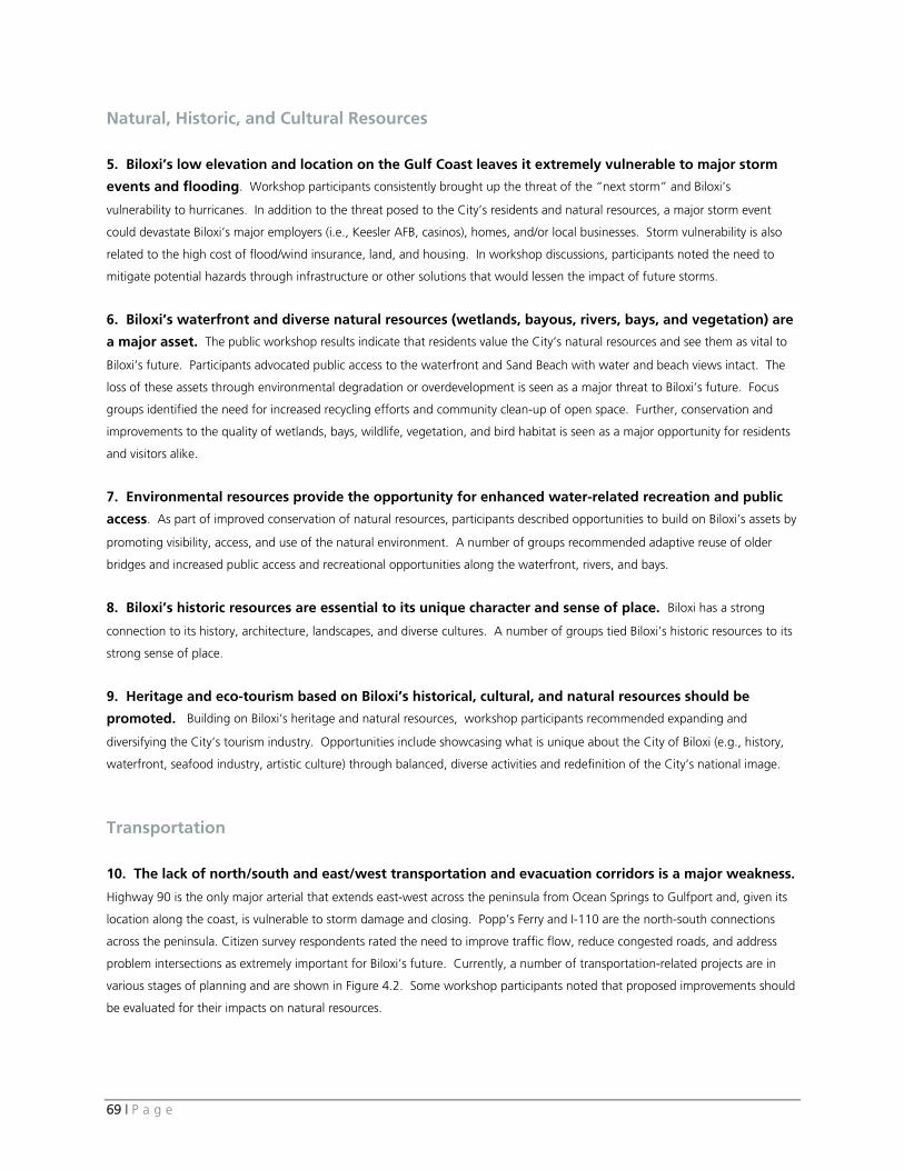
69 | P a g e
Natural, Historic, and Cultural Resources
5. Biloxi’s low elevation and location on the Gulf Coast leaves it extremely vulnerable to major storm
events and flooding. Workshop participants consistently brought up the threat of the “next storm” and Biloxi’s
vulnerability to hurricanes. In addition to the threat posed to the City’s residents and natural resources, a major storm event
could devastate Biloxi’s major employers (i.e., Keesler AFB, casinos), homes, and/or local businesses. Storm vulnerability is also
related to the high cost of flood/wind insurance, land, and housing. In workshop discussions, participants noted the need to
mitigate potential hazards through infrastructure or other solutions that would lessen the impact of future storms.
6. Biloxi’s waterfront and diverse natural resources (wetlands, bayous, rivers, bays, and vegetation) are
a major asset. The public workshop results indicate that residents value the City’s natural resources and see them as vital to
Biloxi’s future. Participants advocated public access to the waterfront and Sand Beach with water and beach views intact. The
loss of these assets through environmental degradation or overdevelopment is seen as a major threat to Biloxi’s future. Focus
groups identified the need for increased recycling efforts and community clean-up of open space. Further, conservation and
improvements to the quality of wetlands, bays, wildlife, vegetation, and bird habitat is seen as a major opportunity for residents
and visitors alike.
7. Environmental resources provide the opportunity for enhanced water-related recreation and public
access. As part of improved conservation of natural resources, participants described opportunities to build on Biloxi’s assets by
promoting visibility, access, and use of the natural environment. A number of groups recommended adaptive reuse of older
bridges and increased public access and recreational opportunities along the waterfront, rivers, and bays.
8. Biloxi’s historic resources are essential to its unique character and sense of place. Biloxi has a strong
connection to its history, architecture, landscapes, and diverse cultures. A number of groups tied Biloxi’s historic resources to its
strong sense of place.
9. Heritage and eco-tourism based on Biloxi’s historical, cultural, and natural resources should be
promoted. Building on Biloxi’s heritage and natural resources, workshop participants recommended expanding and
diversifying the City’s tourism industry. Opportunities include showcasing what is unique about the City of Biloxi (e.g., history,
waterfront, seafood industry, artistic culture) through balanced, diverse activities and redefinition of the City’s national image.
Transportation 10. The lack of north/south and east/west transportation and evacuation corridors is a major weakness.
Highway 90 is the only major arterial that extends east-west across the peninsula from Ocean Springs to Gulfport and, given its
location along the coast, is vulnerable to storm damage and closing. Popp’s Ferry and I-110 are the north-south connections
across the peninsula. Citizen survey respondents rated the need to improve traffic flow, reduce congested roads, and address
problem intersections as extremely important for Biloxi’s future. Currently, a number of transportation-related projects are in
various stages of planning and are shown in Figure 4.2. Some workshop participants noted that proposed improvements should
be evaluated for their impacts on natural resources.
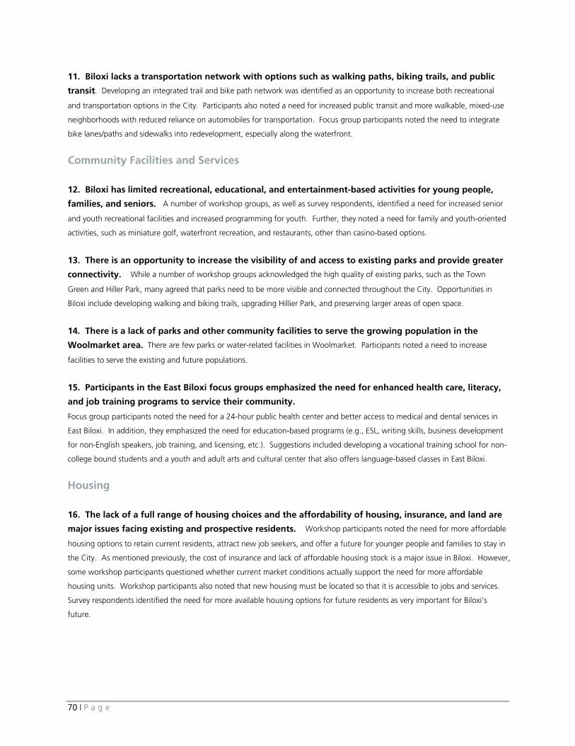
70 | P a g e
11. Biloxi lacks a transportation network with options such as walking paths, biking trails, and public
transit. Developing an integrated trail and bike path network was identified as an opportunity to increase both recreational
and transportation options in the City. Participants also noted a need for increased public transit and more walkable, mixed-use
neighborhoods with reduced reliance on automobiles for transportation. Focus group participants noted the need to integrate
bike lanes/paths and sidewalks into redevelopment, especially along the waterfront.
Community Facilities and Services 12. Biloxi has limited recreational, educational, and entertainment-based activities for young people,
families, and seniors. A number of workshop groups, as well as survey respondents, identified a need for increased senior
and youth recreational facilities and increased programming for youth. Further, they noted a need for family and youth-oriented
activities, such as miniature golf, waterfront recreation, and restaurants, other than casino-based options.
13. There is an opportunity to increase the visibility of and access to existing parks and provide greater
connectivity. While a number of workshop groups acknowledged the high quality of existing parks, such as the Town
Green and Hiller Park, many agreed that parks need to be more visible and connected throughout the City. Opportunities in
Biloxi include developing walking and biking trails, upgrading Hillier Park, and preserving larger areas of open space.
14. There is a lack of parks and other community facilities to serve the growing population in the
Woolmarket area. There are few parks or water-related facilities in Woolmarket. Participants noted a need to increase
facilities to serve the existing and future populations.
15. Participants in the East Biloxi focus groups emphasized the need for enhanced health care, literacy,
and job training programs to service their community.
Focus group participants noted the need for a 24-hour public health center and better access to medical and dental services in
East Biloxi. In addition, they emphasized the need for education-based programs (e.g., ESL, writing skills, business development
for non-English speakers, job training, and licensing, etc.). Suggestions included developing a vocational training school for non-
college bound students and a youth and adult arts and cultural center that also offers language-based classes in East Biloxi.
Housing 16. The lack of a full range of housing choices and the affordability of housing, insurance, and land are
major issues facing existing and prospective residents. Workshop participants noted the need for more affordable
housing options to retain current residents, attract new job seekers, and offer a future for younger people and families to stay in
the City. As mentioned previously, the cost of insurance and lack of affordable housing stock is a major issue in Biloxi. However,
some workshop participants questioned whether current market conditions actually support the need for more affordable
housing units. Workshop participants also noted that new housing must be located so that it is accessible to jobs and services.
Survey respondents identified the need for more available housing options for future residents as very important for Biloxi’s
future.
71 | P a g e
Economic Development 17. Biloxi needs to develop a more diversified economy. A number of workshop groups saw the City’s major
employers (i.e., casinos, Keesler Air Force Base) as strengths but also identified an opportunity and need to diversify the City’s
economy, re-grow its seafood industry, build its tourist industry, and expand its higher educational sector. Workshop groups
indicated the opportunity to increase tourism based on Biloxi’s strengths (e.g., natural resources, history, waterfront, weather,
seafood, etc.). Development of Oak Street as an “international” mixed-use district was identified as an opportunity by the East
Biloxi focus groups. Additionally, the groups emphasized preservation and enhancement of the seafood industry, which includes
improved marinas, commercial, and recreational access to the waterfront and piers and development of the seafood village
concept in East Biloxi. Focus groups also identified the need to preserve agriculturally zoned land and promote locally grown
food and community gardens.
18. The lack of mixed-use, retail, residential, and service development in the downtown is a major
weakness. Public workshop participants expressed support for more mixed-use, pedestrian-friendly types of development in
downtown. As well as promoting more activity, mixed-use development downtown could provide opportunities for small
business and lead to increased economic diversity. Table 9.2 September 2008 Public Meetings Weighted Priorities40
Priority Strengths
1. Natural Resources (Waterfront, Wetlands, Sand Beach, and Environmental Conservation)
2. Economy / Economic Anchors (Casinos, Keesler Air Force Base, Seafood - Industry and Character)
3. People / Friendliness and Hospitality
Priority Weaknesses
1. Affordable Housing / Insurance / Cost of Land 2. Transportation / E/W and N/S Connections 3. Storm Threats and Vulnerability / Low Elevation Priority Threats 1. Low Elevation and Location / Vulnerability to Major Storms (“Next Storm”/ Loss of Major Employers)
2. Lack of Economic Diversity 3. Overdevelopment of Waterfront (Destruction of the Environment) Priority Opportunities
1. “Clean Slate” for High-Quality Redevelopment and Growth (Smart Growth/Mixed-Use Neighborhoods)
2. Enhanced Water Recreation and Waterfront Accessibility (More Activities along the Waterfront and Bays / Harbor Development / Larger Slips for Commercial Development)
3. Development of Diverse Entertainment and Waterfront District (Cultural Attractions for Residents and Visitors/Museums, Performing Arts & Culture Center, Amphitheater / Diverse Entertainment)
40 After listing existing strengths, weaknesses, threats, and opportunities for the City’s future, participants were asked to vote for their top three priorities in each
category. Following the public workshop series, results were weighted (so that the top three priorities were given a score of 3,2, and 1 respectively) and tabulated across groups. The combined results for the top three priorities from all three meetings are shown in Table 9.2. All combined results (regardless of their priority) are shown in Table 9.3.
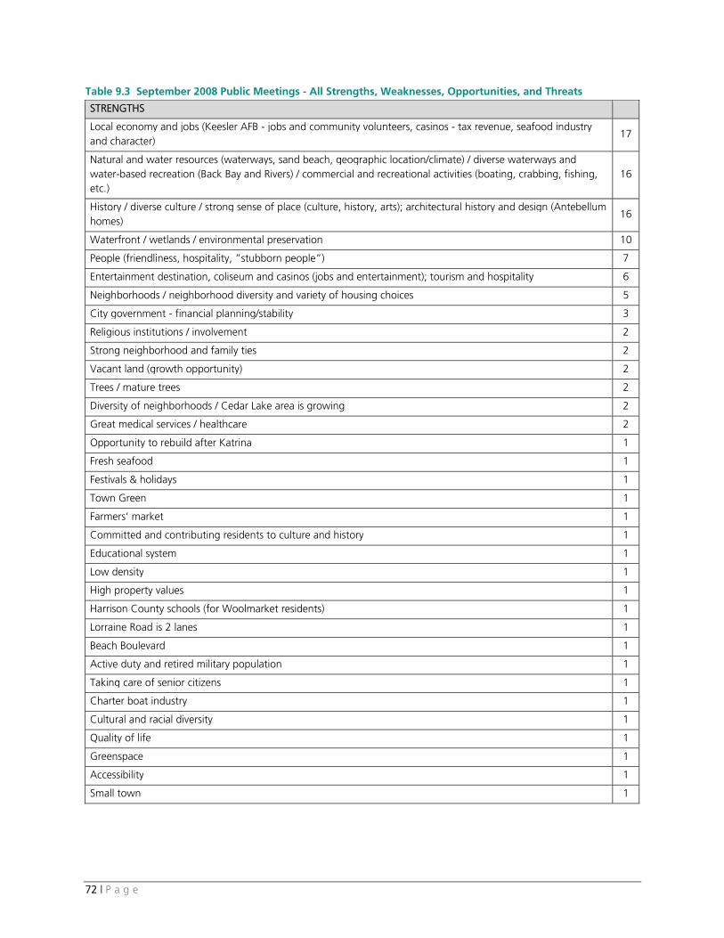
72 | P a g e
Table 9.3 September 2008 Public Meetings - All Strengths, Weaknesses, Opportunities, and Threats
STRENGTHS
Local economy and jobs (Keesler AFB - jobs and community volunteers, casinos - tax revenue, seafood industry and character)
17
Natural and water resources (waterways, sand beach, geographic location/climate) / diverse waterways and water-based recreation (Back Bay and Rivers) / commercial and recreational activities (boating, crabbing, fishing, etc.)
16
History / diverse culture / strong sense of place (culture, history, arts); architectural history and design (Antebellum homes)
16
Waterfront / wetlands / environmental preservation 10
People (friendliness, hospitality, ”stubborn people”) 7
Entertainment destination, coliseum and casinos (jobs and entertainment); tourism and hospitality 6
Neighborhoods / neighborhood diversity and variety of housing choices 5
City government - financial planning/stability 3
Religious institutions / involvement 2
Strong neighborhood and family ties 2
Vacant land (growth opportunity) 2
Trees / mature trees 2
Diversity of neighborhoods / Cedar Lake area is growing 2
Great medical services / healthcare 2
Opportunity to rebuild after Katrina 1
Fresh seafood 1
Festivals & holidays 1
Town Green 1
Farmers’ market 1
Committed and contributing residents to culture and history 1
Educational system 1
Low density 1
High property values 1
Harrison County schools (for Woolmarket residents) 1
Lorraine Road is 2 lanes 1
Beach Boulevard 1
Active duty and retired military population 1
Taking care of senior citizens 1
Charter boat industry 1
Cultural and racial diversity 1
Quality of life 1
Greenspace 1
Accessibility 1
Small town 1
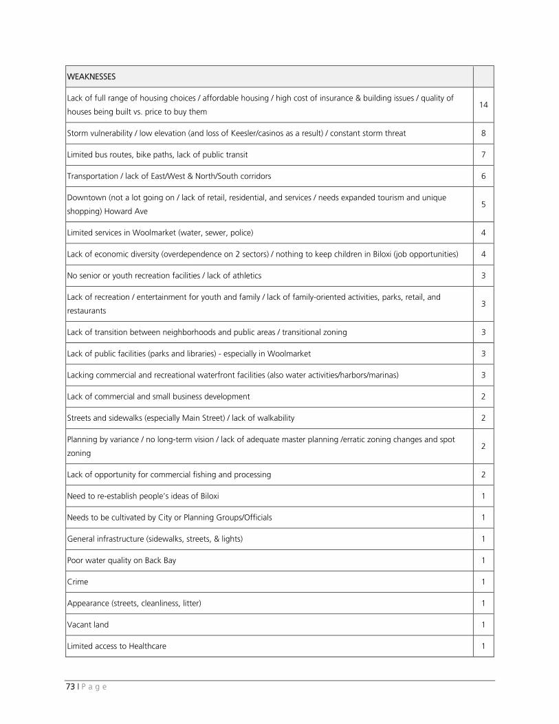
73 | P a g e
WEAKNESSES
Lack of full range of housing choices / affordable housing / high cost of insurance & building issues / quality of
houses being built vs. price to buy them 14
Storm vulnerability / low elevation (and loss of Keesler/casinos as a result) / constant storm threat 8
Limited bus routes, bike paths, lack of public transit 7
Transportation / lack of East/West & North/South corridors 6
Downtown (not a lot going on / lack of retail, residential, and services / needs expanded tourism and unique
shopping) Howard Ave 5
Limited services in Woolmarket (water, sewer, police) 4
Lack of economic diversity (overdependence on 2 sectors) / nothing to keep children in Biloxi (job opportunities) 4
No senior or youth recreation facilities / lack of athletics 3
Lack of recreation / entertainment for youth and family / lack of family-oriented activities, parks, retail, and
restaurants 3
Lack of transition between neighborhoods and public areas / transitional zoning 3
Lack of public facilities (parks and libraries) - especially in Woolmarket 3
Lacking commercial and recreational waterfront facilities (also water activities/harbors/marinas) 3
Lack of commercial and small business development 2
Streets and sidewalks (especially Main Street) / lack of walkability 2
Planning by variance / no long-term vision / lack of adequate master planning /erratic zoning changes and spot
zoning 2
Lack of opportunity for commercial fishing and processing 2
Need to re-establish people’s ideas of Biloxi 1
Needs to be cultivated by City or Planning Groups/Officials 1
General infrastructure (sidewalks, streets, & lights) 1
Poor water quality on Back Bay 1
Crime 1
Appearance (streets, cleanliness, litter) 1
Vacant land 1
Limited access to Healthcare 1
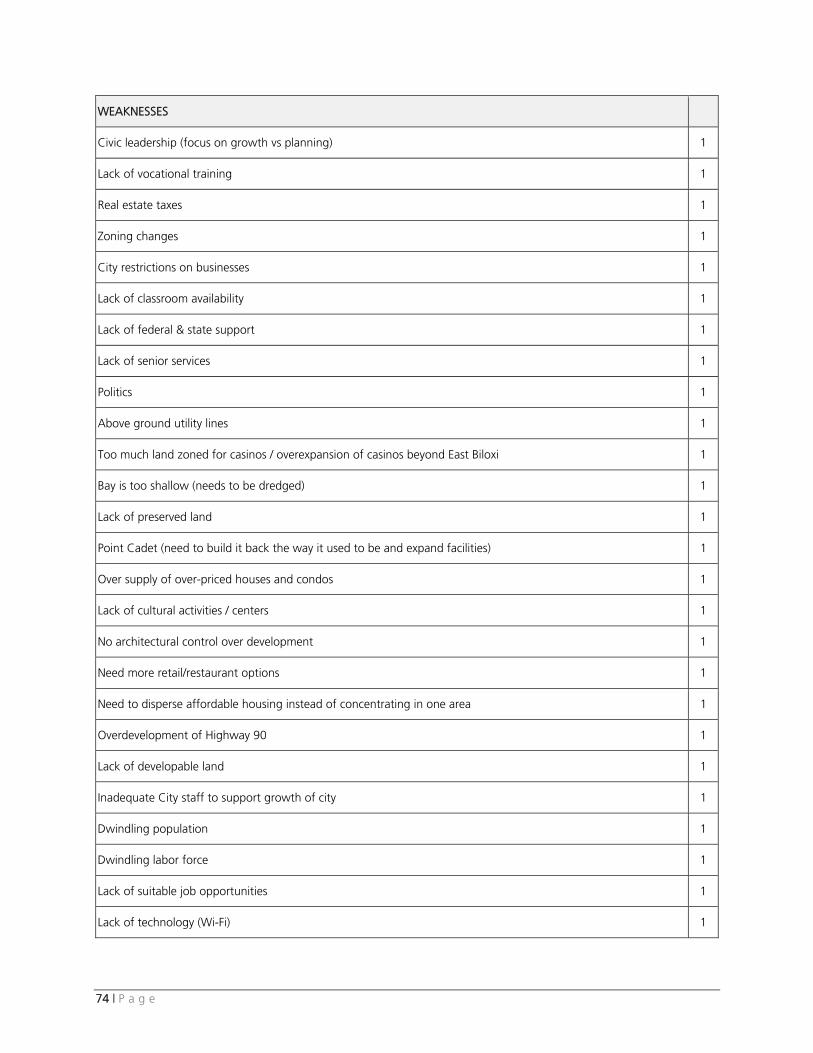
74 | P a g e
WEAKNESSES
Civic leadership (focus on growth vs planning) 1
Lack of vocational training 1
Real estate taxes 1
Zoning changes 1
City restrictions on businesses 1
Lack of classroom availability 1
Lack of federal & state support 1
Lack of senior services 1
Politics 1
Above ground utility lines 1
Too much land zoned for casinos / overexpansion of casinos beyond East Biloxi 1
Bay is too shallow (needs to be dredged) 1
Lack of preserved land 1
Point Cadet (need to build it back the way it used to be and expand facilities) 1
Over supply of over-priced houses and condos 1
Lack of cultural activities / centers 1
No architectural control over development 1
Need more retail/restaurant options 1
Need to disperse affordable housing instead of concentrating in one area 1
Overdevelopment of Highway 90 1
Lack of developable land 1
Inadequate City staff to support growth of city 1
Dwindling population 1
Dwindling labor force 1
Lack of suitable job opportunities 1
Lack of technology (Wi-Fi) 1
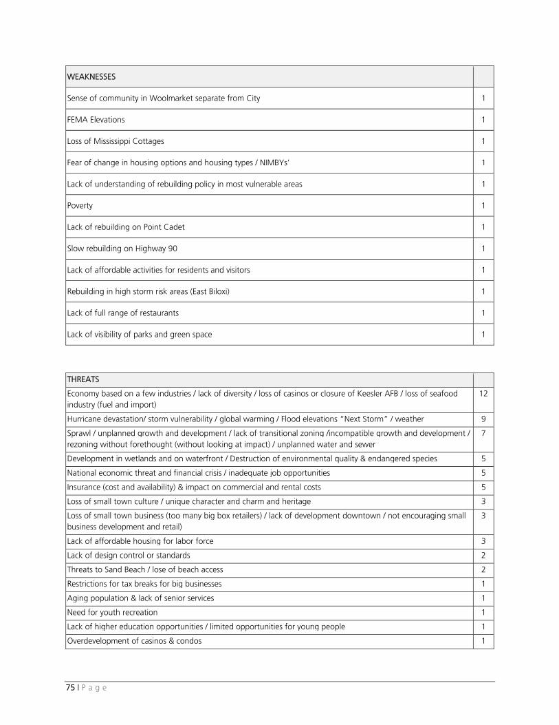
75 | P a g e
WEAKNESSES
Sense of community in Woolmarket separate from City 1
FEMA Elevations 1
Loss of Mississippi Cottages 1
Fear of change in housing options and housing types / NIMBYs’ 1
Lack of understanding of rebuilding policy in most vulnerable areas 1
Poverty 1
Lack of rebuilding on Point Cadet 1
Slow rebuilding on Highway 90 1
Lack of affordable activities for residents and visitors 1
Rebuilding in high storm risk areas (East Biloxi) 1
Lack of full range of restaurants 1
Lack of visibility of parks and green space 1
THREATS
Economy based on a few industries / lack of diversity / loss of casinos or closure of Keesler AFB / loss of seafood industry (fuel and import)
12
Hurricane devastation/ storm vulnerability / global warming / Flood elevations “Next Storm” / weather 9
Sprawl / unplanned growth and development / lack of transitional zoning /incompatible growth and development / rezoning without forethought (without looking at impact) / unplanned water and sewer
7
Development in wetlands and on waterfront / Destruction of environmental quality & endangered species 5
National economic threat and financial crisis / inadequate job opportunities 5
Insurance (cost and availability) & impact on commercial and rental costs 5
Loss of small town culture / unique character and charm and heritage 3
Loss of small town business (too many big box retailers) / lack of development downtown / not encouraging small business development and retail)
3
Lack of affordable housing for labor force 3
Lack of design control or standards 2
Threats to Sand Beach / lose of beach access 2
Restrictions for tax breaks for big businesses 1
Aging population & lack of senior services 1
Need for youth recreation 1
Lack of higher education opportunities / limited opportunities for young people 1
Overdevelopment of casinos & condos 1
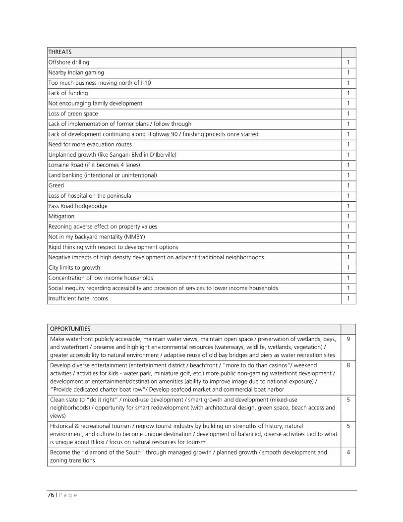
76 | P a g e
THREATS
Offshore drilling 1
Nearby Indian gaming 1
Too much business moving north of I-10 1
Lack of funding 1
Not encouraging family development 1
Loss of green space 1
Lack of implementation of former plans / follow through 1
Lack of development continuing along Highway 90 / finishing projects once started 1
Need for more evacuation routes 1
Unplanned growth (like Sangani Blvd in D’Iberville) 1
Lorraine Road (if it becomes 4 lanes) 1
Land banking (intentional or unintentional) 1
Greed 1
Loss of hospital on the peninsula 1
Pass Road hodgepodge 1
Mitigation 1
Rezoning adverse effect on property values 1
Not in my backyard mentality (NIMBY) 1
Rigid thinking with respect to development options 1
Negative impacts of high density development on adjacent traditional neighborhoods 1
City limits to growth 1
Concentration of low income households 1
Social inequity regarding accessibility and provision of services to lower income households 1
Insufficient hotel rooms 1
OPPORTUNITIES
Make waterfront publicly accessible, maintain water views, maintain open space / preservation of wetlands, bays, and waterfront / preserve and highlight environmental resources (waterways, wildlife, wetlands, vegetation) / greater accessibility to natural environment / adaptive reuse of old bay bridges and piers as water recreation sites
9
Develop diverse entertainment (entertainment district / beachfront / ”more to do than casinos”/ weekend activities / activities for kids - water park, miniature golf, etc.) more public non-gaming waterfront development / development of entertainment/destination amenities (ability to improve image due to national exposure) / “Provide dedicated charter boat row”/ Develop seafood market and commercial boat harbor
8
Clean slate to “do it right” / mixed-use development / smart growth and development (mixed-use neighborhoods) / opportunity for smart redevelopment (with architectural design, green space, beach access and views)
5
Historical & recreational tourism / regrow tourist industry by building on strengths of history, natural environment, and culture to become unique destination / development of balanced, diverse activities tied to what is unique about Biloxi / focus on natural resources for tourism
5
Become the “diamond of the South” through managed growth / planned growth / smooth development and zoning transitions
4
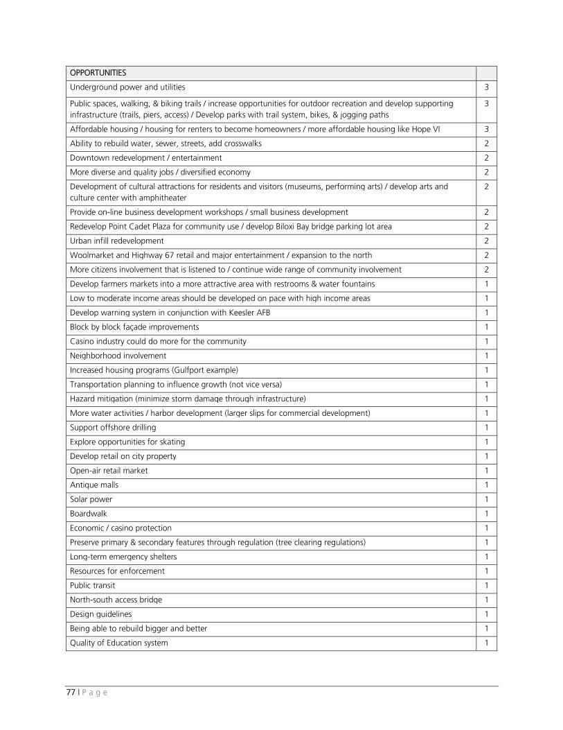
77 | P a g e
OPPORTUNITIES
Underground power and utilities 3
Public spaces, walking, & biking trails / increase opportunities for outdoor recreation and develop supporting infrastructure (trails, piers, access) / Develop parks with trail system, bikes, & jogging paths
3
Affordable housing / housing for renters to become homeowners / more affordable housing like Hope VI 3
Ability to rebuild water, sewer, streets, add crosswalks 2
Downtown redevelopment / entertainment 2
More diverse and quality jobs / diversified economy 2
Development of cultural attractions for residents and visitors (museums, performing arts) / develop arts and culture center with amphitheater
2
Provide on-line business development workshops / small business development 2
Redevelop Point Cadet Plaza for community use / develop Biloxi Bay bridge parking lot area 2
Urban infill redevelopment 2
Woolmarket and Highway 67 retail and major entertainment / expansion to the north 2
More citizens involvement that is listened to / continue wide range of community involvement 2
Develop farmers markets into a more attractive area with restrooms & water fountains 1
Low to moderate income areas should be developed on pace with high income areas 1
Develop warning system in conjunction with Keesler AFB 1
Block by block façade improvements 1
Casino industry could do more for the community 1
Neighborhood involvement 1
Increased housing programs (Gulfport example) 1
Transportation planning to influence growth (not vice versa) 1
Hazard mitigation (minimize storm damage through infrastructure) 1
More water activities / harbor development (larger slips for commercial development) 1
Support offshore drilling 1
Explore opportunities for skating 1
Develop retail on city property 1
Open-air retail market 1
Antique malls 1
Solar power 1
Boardwalk 1
Economic / casino protection 1
Preserve primary & secondary features through regulation (tree clearing regulations) 1
Long-term emergency shelters 1
Resources for enforcement 1
Public transit 1
North-south access bridge 1
Design guidelines 1
Being able to rebuild bigger and better 1
Quality of Education system 1
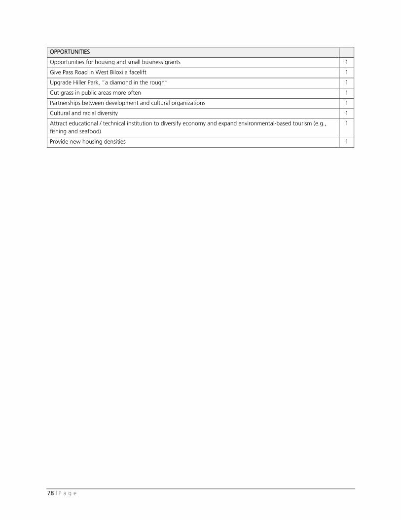
78 | P a g e
OPPORTUNITIES
Opportunities for housing and small business grants 1
Give Pass Road in West Biloxi a facelift 1
Upgrade Hiller Park, “a diamond in the rough” 1
Cut grass in public areas more often 1
Partnerships between development and cultural organizations 1
Cultural and racial diversity 1
Attract educational / technical institution to diversify economy and expand environmental-based tourism (e.g., fishing and seafood)
1
Provide new housing densities 1