Biking Information
10
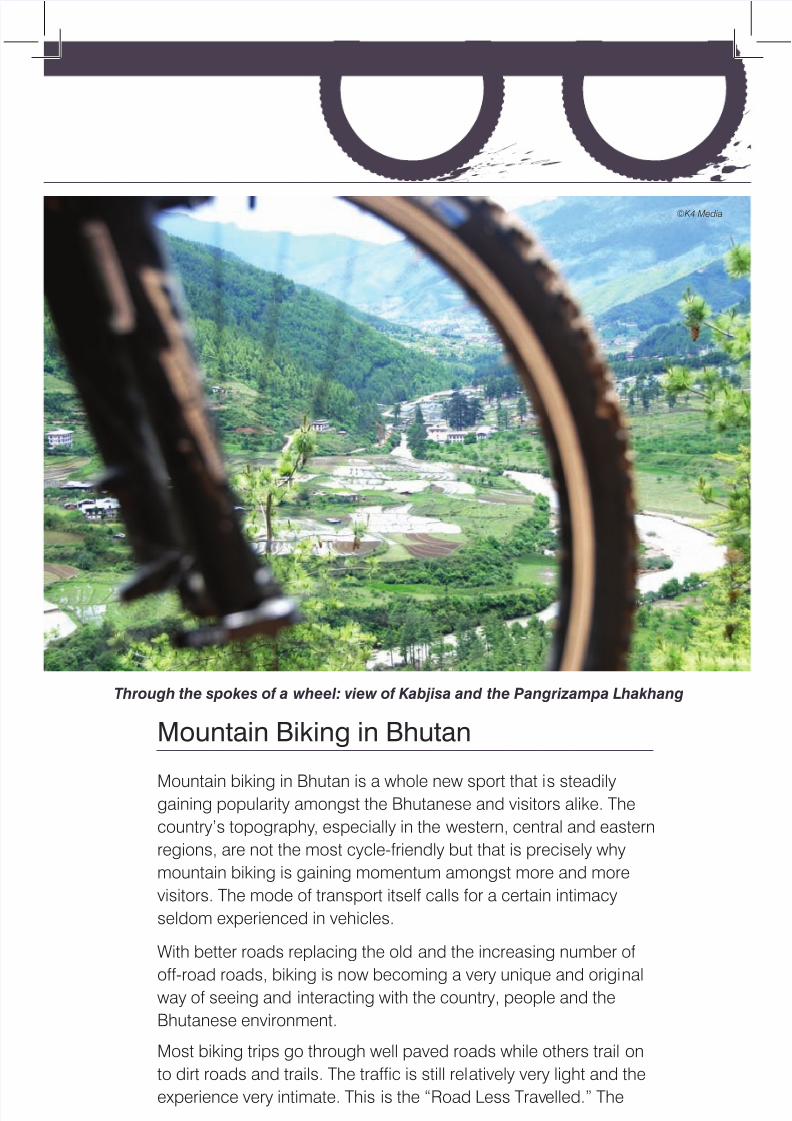
Mountain Biking in Bhutan Mountain biking in Bhutan is a whole new sport that i s steadily gaining popularity amongst the Bhutanese and visitors alike. The country’s topography , especially in the western, central and eastern regions, are not the most cycle-friendly but that is precisely why mountain biking is gaining momentum amongst more and more visitors. The mode of transport itself calls for a certain intimacy seldom experienced in vehicles. With better roads replacing the old and the increasing number of off-road roads, biking is now becoming a very unique and origi nal way of seeing and interacting with the country, people and the Bhutanese environment. Most biking trips go through well paved roads while others trail on to dirt roads and trails. The traffic is still rel atively very light and the experience very intimate. This is the “Road Less Trav elled.” The Through the spokes of a wheel: view of Kabjisa and the Pangrizampa Lhakhang ©K4 Media
-
Upload
jambay-dukpa -
Category
Documents
-
view
229 -
download
0
Transcript of Biking Information
7/31/2019 Biking Information
http://slidepdf.com/reader/full/biking-information 1/9
Mountain Biking in Bhutan
Mountain biking in Bhutan is a whole new sport that is steadilygaining popularity amongst the Bhutanese and visitors alike. The
country’s topography, especially in the western, central and eastern
regions, are not the most cycle-friendly but that is precisely why
mountain biking is gaining momentum amongst more and more
visitors. The mode of transport itself calls for a certain intimacy
seldom experienced in vehicles.
With better roads replacing the old and the increasing number of
off-road roads, biking is now becoming a very unique and originalway of seeing and interacting with the country, people and the
Bhutanese environment.
Most biking trips go through well paved roads while others trail on
to dirt roads and trails. The traffic is still relatively very light and the
experience very intimate. This is the “Road Less Travelled.” The
Through the spokes of a wheel: view of Kabjisa and the Pangrizampa Lhakhang
©K4 Media
7/31/2019 Biking Information
http://slidepdf.com/reader/full/biking-information 2/9
Gasa
Punakha
Thimphu Wangdue
Paro
Haa
Chukha
Trongsa
Jakar
Zhemgang Mongar
Trashigang
SamdrupjongkharGelephu
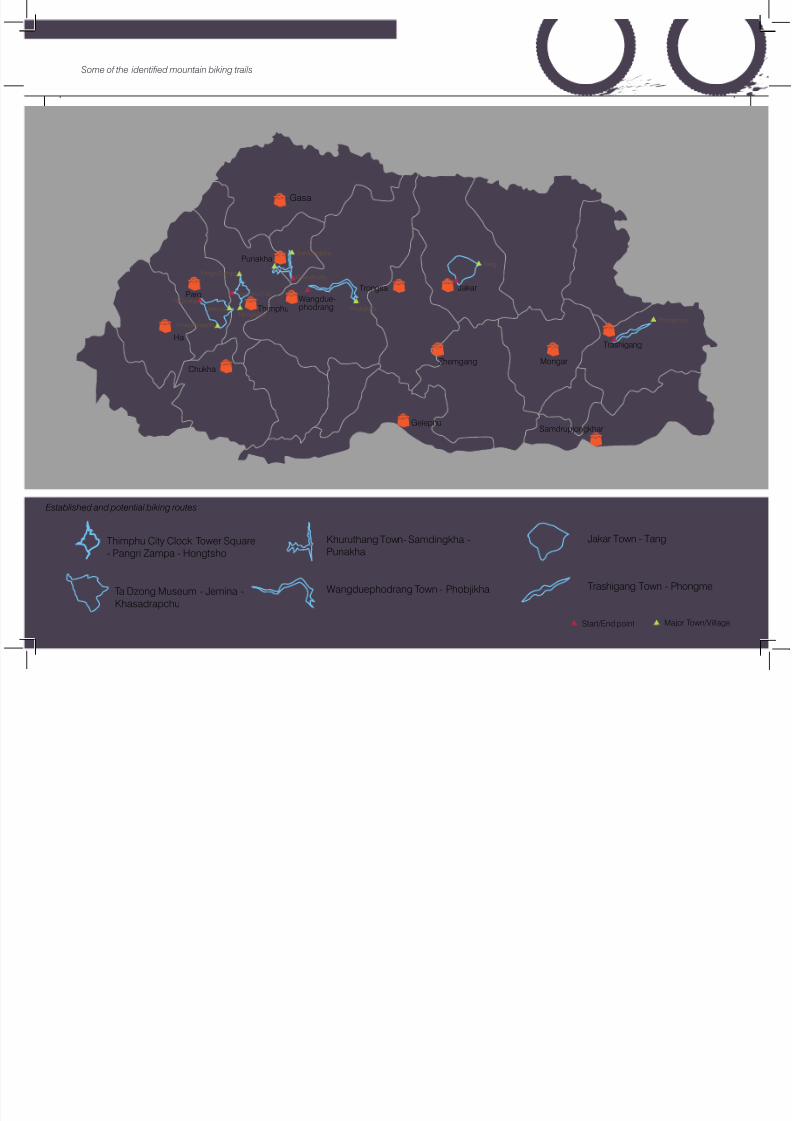
Khuruthang Town- Samdingkha -
Punakha
Wangduephodrang Town - Phobjikha
Jakar Town - Tang
Trashigang Town - Phongme
Gasa
Punakha
ThimphuWangdue-phodrang
Paro
Ha
Chukha
Trongsa
Thimphu City Clock Tower Square
- Pangri Zampa - Hongtsho
Ta Dzong Museum - Jemina -Khasadrapchu
Phongmey
Phobjikha
Pangri Zampa
Hongtsho
Thimphu CityTa Dzong
Jemina
Khasadrapchu
Samdingkha
Khuruthang
Start/End point Major Town/Village
Tang
Some of the identified mountain biking trails
Established and potential biking routes

7/31/2019 Biking Information
http://slidepdf.com/reader/full/biking-information 3/9
We continue biking until Thimphu City to make a loop. A map il-
lustrating the trail is provided in the following page under the title
“Pangrizampa – Hongtsho Mountain Biking Trail”.
The trail falls between an altitude of 2,300 and 3,700m above sea
level. The total length of trail loop is 46 km.
Blue pine - coniferous forests along the Thimphu - Pangrizampa –
Hongtsho Trail
more adventurous have the option of making side excursions for
more “off-the-road” ventures if preferred. The surface accommo-
dates most types of frame styles: from MTB, Hybrid, and Road, de-
pending on your cycling style and experience. Biking trails mostly
meander through small towns and villages and rural areas; it’s just
you, your bike, the tour group and the agrarian and natural scenery.
Biking in Bhutan allows you many opportunities for self reflectionalong with the absorbing, rich environment. There are also numer-
ous opportunities for optional hikes with a bit of climbing thrown in.
There are some challenging climbs with one in particular that is
more than seven hours. You peddle the pads over two miles (3,400
meters) above sea level. The effort made is equally rewarded with a
view and an experience that is as rare as anything in this increas-
ingly globalizing and monotonous world. Riders should have an
adequate level of fitness and stamina and be experienced enough
in the art of mountain biking.
Tours are fully supported by a van following riders. The van allows
riders the option to sit in and take a break.
Description of Trails
Thimphu - Pangrizampa - Hongtsho
Physical Description
The Pangrizampa – Hongtsho trail starts from the Thimphu Town
Square (known locally as the Clock Tower) and continues biking
along the Thimphu - Dechencholing highway until the junction at
Dechencholing – Pangrizampa and Dechencholing – Tango/Cheri
road. From here we follow the dirt motor vehicle road until Pangri-
zampa (the bridge of Pangri). From Pangrizampa the biking ascends
along the logging road until Taba Top at an average gradient of 11%.
The logging road ends here.
©K4 Media

7/31/2019 Biking Information
http://slidepdf.com/reader/full/biking-information 4/9
Physical details
Flora and Fauna
The trail is home to vegetation ranging from blue pine forests in
the lower valley to mixed coniferous forest at higher altitudes. The
forest type is basically coniferous in nature which supports less
wildlife than broad leaf forests. The main vegetation found here
are Blue Pine, Poplar, Oak, Hemlock, Spruce, Fir, Larch, Juniper,Rhododendron et al.
Natural gradients on most off-road trails pose quite a challenge
Chainage(km+m)
LocationAltitude(Meter)
AverageGradient (%)
0+000 – 8+000 Thimphu City – Pangr izampa 2350 – 2420 +5
8+000 – 15+000 Pangrizampa - Taba Top 3090 +11
15+000 – 18+621Taba Top - Sinchula Road ForestJunction
3500 +10
18+621 – 22+621Sinchula Road Junction – SinchulaPass
3650 +7
22+621 – 31+621 Sinchula Pass – Hongtsho 2920 -10
31+621 – 39+621 Hongtsho – Semtokha 2250 -9
39+621 – 45+621 Semtokha – Thimphu City Square 2350 -3
Pangrizampa Lhakhang is a few minutes ride away from Thimphu
Town
Socio-cultural glances
Some important cultural entities that can be viewed by biking
along the Thimphu -Pangrizampa – Hongtsho trail are the Tashi
Chho Dzong, the Parliament building, Dechenphodrang Lhakhang,
Dechencholing Palace, Pangrizampa Lhakhang and Kabjisa
village. From the Taba Top, a bird’s eye-view of the following
monasteries are visible: Dodedra, Tango and Cheri monasteries.
From Sinchula Pass a glorious vista awaits the rider in the form of
the snow capped Himalayan eastern range, including Jhumolhari.
As the trail descends towards Hongtsho, clear views of Hongtsho
valley overlooking the Trashigang monastery across the valley can
be seen. As the journey ends, you come across Semtokha Dzong,
the oldest in Bhutan and after about 5 km r ide from here, you will
be back at the Clock Tower Square.
©K4 Media
©K4 Media

7/31/2019 Biking Information
http://slidepdf.com/reader/full/biking-information 5/9
Punakha
A vantage view of Khuruthang Town, Punakha
Punakha, the old capital, is a pleasant sub-tropical valley. It is
home to the impressive Pungthang Dewachenpoi Phodrang
Dzong- the administrative and religious centre of the district. In
winter it is home to the Bhutanese Central Monk Body. Since the
1680s the dzong has also been the site of a continuous vigil over
the earthly body of Shabdrung Ngawang Namgyal, the founder
of the country, which lies in a special chamber in the dzong. Built
by Shabdrung Ngwang Namgyal in the 17th century, the fortress
stands at the confluence of two rivers- the Pho (male) Chhu and
Mo (female) Chhu Rivers.
Khuruthang – Samdingkha – Punakha
Physical Description
Although the proposed biking journey is over 17 km, the new trail
construction is slightly over 7 km. The proposed journey will take
off at Khuruthang and stay along the feeder road until the footpath
suspension bridge at Samdingkha.
From Samdingkha the new trail mostly follows along the footpath
at an average gradient of 10% until Punakha Dzong where the trail
connects to the road. The terrain topography of the new trail is
generally steep exceeding 100% in some stretches. However, the
trail is an up-gradation of the footpath.
After reaching Punakha Dzong, you keep following the asphalt
road along the Mo Chhu till Khuruthang town, a place to stretch the
arms and spend a night at the cosy hotels.
Topographical details on the proposed new trail construction is
provided in Table 3-15.
Table 3-15. Side slope (Topography) details along the proposed
construction
ChainageAltitude(Meter)
AverageGradient (%)
Average SideSlope (%)
Remarks
0+000 1280Samdingkha SuspensionBridge
2+600 1280 +9, -5 40 Start of Critical Gorge Area
2+730 1280 +17, -9 70 Critical Gorge Area
6+330 1290 ±7 56 Top of the Rocky Cliff
7+230 1240 -15 67 Near Crematorium
©Tashi Loday

7/31/2019 Biking Information
http://slidepdf.com/reader/full/biking-information 6/9
Flora & Fauna
Chir pine is the dominant forest with very little undergrowths. These
forests are poor in terrestrial birds. However, along river courses
plenty of water birds can be spotted especially during winters.
Some of the resident water birds are: Ruddy Shelduck, Common
Shelduck, Mallard, Crested Kingfisher, White-throated Kingfisher,
Great Cormorant, River Lapwing and Ibisbill.
High on the mountains: Bikers along a typical Bhutanese road
Socio-cultural Glances
Punakha is the ancient capital of Bhutan and the winter residence
of the Central Monastic body. The Punakha Dzong is one of the
most impressive in Bhutan- built at the confluence of the rivers Pho
Chhu and the Mo Chhu. It has survived many natural disasters (the
most recent were floods caused by glacial lake outburst upstream
of the Pho Chhu.) The trail passes through several villages: Jimith-
ang, Manakha, Jara, Samdingkha, Jangkhorlo and Tempakha.
The Punakha Dzong is a rich visual splendour. A calm Mo Chhu
glides by
Physical details: The Khuruthang – Samdingkha – Punakha Trail
Chainage Location Altitude (Meter) Average Gradient (%)
0+000 – 6+000 Khuruthang –Manakha
1240 – 1240 m +2
6+000 – 14+000 Samdingkha 1280 m +2 (Except the fewzigs before Samding-kha is around 8%)
14+000 – 21+256 Punakha Dzong 1240 m ±10
21+256 – 27+256 Khuruthang 1240 m ±1
© Tourism Council of Bhutan
©Tashi Loday
7/31/2019 Biking Information
http://slidepdf.com/reader/full/biking-information 7/9
Side slope (Topography) details
Paro Dzongkhag
Paro Dzong with Ta Dzong (the National Museum) in the background
There are two potential biking trails: Jemina (in Thimphu) – Ta
Dzong (in Paro); and Wochu – Dzongdrakha – Bondey trails. The
trails snake through pastoral landscapes and stunning sceneries.
ChainageAltitude(Meter)
AverageGradient (%)
Average SideSlope (%)
Remarks
0+000 1280Samdingkha SuspensionBridge
2+600 1280 +9, -5 40 Start of Critical Gorge Area
2+730 1280 +17, -9 70 Critical Gorge Area
6+330 1290 ±7 56 Top of the Rocky Cliff
7+230 1240 -15 67 Near Crematorium
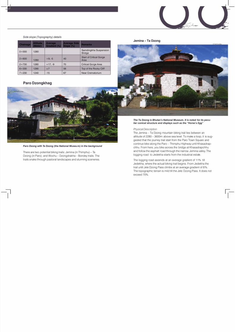
Jemina – Ta Dzong
The Ta Dzong is Bhutan’s National Museum. It is noted for its pecu-
liar conical structure and displays such as the “Horse’s Egg”
Physical Description
The Jemina – Ta Dzong mountain biking trail lies between an
altitude of 2280 – 3600m above sea level. To make a loop, it is sug-
gested that the journey trail start from the Paro Town Square and
continue bike along the Paro – Thimphu Highway until Khasadrap-
chhu. From here, you bike across the bridge at Khasadrapchhu
and follow the asphalt road through the narrow Jemina valley. The
logging road to Jedekha starts from the industrial estate.
The logging road ascends at an average gradient of 11% till
Jedekha, where the actual biking trail begins. From Jedekha the
trail until Jele Dzong Pass climbs at an average gradient of 8%.
The topographic terrain is mild till the Jele Dzong Pass. It does not
exceed 70%.
©Tashi Loday
©Tashi Loday

7/31/2019 Biking Information
http://slidepdf.com/reader/full/biking-information 8/9
From the pass the trail descends continuously and in some places
the trail bends sharply at an average gradient of 15% until it meets
the farm road. The farm road ends near the Ta Dzong gate. You
follow the asphalt road to get back to the starting point. The
topographic terrain from the pass till Ta Dzong is very mild with an
average side slope of 40%. In occasional bends the side slope
goes up to 80% to a stretch of about 50m. The map illustrating the
trail is provided below.
Physical details: The Jemina – Ta Dzong Trail
Chainage(0km+000km)
LocationAltitude(Meter)
AverageGradient (%)
0+000 – 4+000 Paro City Square – Bondey 2280 – 2230 m 0
4+000 – 24+000 Bondey – Chuzom 2160 m ±2
24+000 – 39+000 Chuzom – Khasadrapchu 2240 m +5
39+000 – 44+000 Khasadrapchu – Jemina 2450 m +6
44+000 – 57+500 Jemina – Jedekha 3235 m +11
57+500 – 61+443 Jedekha - Jele Dzong 3560 m +8
61+443 – 67+563 Jele Dzong – Damchena 2915 m -15
67+563 – 72+563 Damchena - Ta Dzong 2740 m -11
72+563 – 77+563 Ta Dzong - Paro City Square 2280 m - 8
Side slope (Topography) details along the proposed construction
Flora & Fauna
There are four type of vegetation along the trail. The vegetation
changes as the altitude elevates. Blue pine forest is prominent in
the lower altitude, mixed coniferous forest in the middle range, fir
forest and Juniper forest around the pass. The main tree species
are Blue pine, Poplar, Walnut, Oak, Hemlock, Spruce, Fir, Larch,
Juniper, Rhododendron et al.
A lush clearing along the Blue Pine forests on the Jemina trail
ChainageAltitude(Meter)
AverageGradient (%)
Average SideSlope (%)
Remarks
0+000 3235 0 31 Jedekha Junction
3+943 3560 + 8% 29 Unitl Jele Dzong
5+194 3300 - 15% 44 Slide prone area
6+269 3220 - 15% 36
8+146 2915 - 15% end Junction with farm roadTachoe Lhakhang along the Paro - Thimphu highway. (right) Ruins
from another time
©Tashi Loday ©Tashi Loday
©Tashi Loday

7/31/2019 Biking Information
http://slidepdf.com/reader/full/biking-information 9/9
Although the forest type is not home to bird life, a few bird species
that roost here are Nutcrackers, Yellow-billed Magpie, Whistling
Thrush, Darjeeling Woodpecker, Kalij Pheasant, Blood Pheasant,
Coal Tit and Wood Snipe. Wild animals are elusive but droppings
confirm the presence of Wild cats, Deer, and Leopards.
I n B h u t a n ,
i t i s
M o u n t a i n B i k i n g a n d t h e a r t o f m a n u e v e r i n g m e a n d e r i n g r o a d s
© K 4 M e d i a