BIHAR FLOODS : 2007 - NIDM : Home Flood 2007.pdf · DELUXE PRINTERY, B-217, Naraina Industrial...
74
BIHAR FLOODS : 2007 (A Field Report) Towards a disaster free India NATIONAL INSTITUTE OF DISASTER MANAGEMENT (Ministry of Home Affairs, Government of India) 5B, IP Estate, Mahatma Gandhi Marg, New Delhi-110002 (India) T: +91 11 23702432, 23705583, 23766146, F: +91 11 23702442, 23702446 I: www.nidm.gov.in IIPA Campus,
Transcript of BIHAR FLOODS : 2007 - NIDM : Home Flood 2007.pdf · DELUXE PRINTERY, B-217, Naraina Industrial...

BIHAR FLOODS : 2007(A Field Report)
Towards a disaster free India
NATIONAL INSTITUTE OF DISASTER MANAGEMENT (Ministry of Home Affairs, Government of India)
5B, IP Estate, Mahatma Gandhi Marg, New Delhi-110002 (India) T: +91 11 23702432, 23705583, 23766146, F: +91 11 23702442, 23702446 I: www.nidm.gov.in
IIPA Campus,

BIHAR FLOODS : 2007(A Field Report)
Authors :
Santosh Kumar
Arun Sahdeo
Sushma Guleria

Bihar Floods : 2007
(A Field Report)
ISBN : 978-93-82571-04-9
© NIDM, New Delhi
Printing Committee :
Dr. Surya Parkash
Mr. Ramesh Kumar
Mr. Shekhar Chaturvedi
Mr. S.K. Tiwari
First, 2013
Published by :
National Institute of Disaster Management, Ministry of Home Affairs,
New Delhi - 110002
Design and Printing:
DELUXE PRINTERY, B-217, Naraina Industrial Area, Pahse-I, New Delhi-110028.
Ph.: 011-45040279, 9811295120/110
Edition :

In recent past flooding and the associated risks have been rising with increased fre-
quency in India which could be attributed to a number of factors, including changes in rainfall
pattern, increased frequency of extreme events, in land use changes and development into flood-
prone areas as a result of socio-economic demand. Of late, it has been realized that climate
changes is causing significant impact on the hydrological system and increasing the risk and
vulnerability to flooding. Human lives, property, environment and socio-economic are at increas-
ing risk due to flooding.
Bihar is highly vulnerable to floods on account of its geo-climatic conditions and various
other attributing factors. The State is the most flood prone in the country in terms of percentage of
land susceptible to flooding. Total flood prone area of the State is about 68.80 lakh hectares which
accounts for 73.06 percent of its total geographical area and 17.2 percent of the total flood prone
area in the country. The State has witnessed devastating floods in recent years. In fact, South West
Monsoon rain has become a synonyms of floods in North Bihar plains resulting in enormous loss
of life and property and bringing untold human miseries and sufferings to the people.
The floods in Bihar during the South West Monsoon 2007 (July to September 2007)
portray yet another familiar picture of the State’s vulnerability to recurrent flood and is a grim
reminder of the extensive devastations destruction and disruption caused by floods. The floods of
2007 make a break from the past in terms of; its intensity, unpredictability and its un-seasonlity.
About twenty days of incessant rains, 300 to 400% over and above normal trends in second half of
July, had been unprecedented. This was again repeated in August and simultaneously, heavy rain-
fall in the upper catchments areas of Nepal compounded the problem.
The purpose of documentation of this disaster event by the National Institute of Disaster
Management is to draw important lessons from floods and its management. The focus of the study
is to highlight on the practical problems, dilemmas and challenges and to suggest measures for
reducing the loss of life and property due to major floods. The study clearly establishes the needs
for a comprehensive approach on flood hazards with a broader perspective of flood plain manage-
ment, non-structural approaches, and institutional innovations which may be used for integrated,
comprehensive flood control strategies.
Satendra
(Executive Director)
PREFACE
We would like to thank every one who was instrumental in making the present piece of
documentation a success. Firstly, we are grateful to Shri P. G. Dhar Chakrabarty, the then Executive
Director, NIDM for providing us the opportunity to take up this study.
We are thankful to Director and Faculty Member of Bihar Institute of Public
Administration and Rural Development (BIPARD) for their valuable co-operation and able
guidance at various stages of the study.
We have the honour to put on record Shri S. K. Srivastava Relief Commissioner for his able
guidance and brilliant suggestions based on his rich knowledge and vast experience, in spite of his
tight and busy schedule.
We have the honour to express our deep sense of gratitude to all the District Magistrates
of the districts wherein the study was conducted namely; East Champaran, Begusarai and Vaishali
along with the District Magistrate of Patna for their immense support and valuable contribution in
providing inputs during the entire field visit.
We take the opportunity to express our deep sense of gratitude and thankfulness to Shri
Sanjay Pandey and his team from UNICEF office, Patna for providing us with some valuable
information pertaining to the relief work during the flood event.
We are obliged to Dr. Rajan Sinha, Director, Professor G.P. Sinha Centre for Disaster
Management and Rural Development (GPSCDMRD) for his in-depth discussions and brilliant
suggestions.
We are also thankful to all the District Project Officers from UNDP of the four study
districts for their valuable support in facilitating the field visit as well as an interface with the
community for collecting field information after the disaster.
Professor Santosh Kumar
Arun Shadeo
Sushma Guleria
ACKNOWLEDGEMENT

CONTENTS1) Preface iii
2) Acknowledgement iv
3) Chapter 1: Introduction 1
4) Chapter 2: Vulnerability of Bihar to Floods 4-12
5) Chapter 3: Floods in 2007 13-26
6) Chapter 4: Mitigation & Management of floods in Bihar 27-33
7) Chapter 5: Recommendations/ Suggestions 34-43
9) Annexure 44-65
8) References 66
a) Physical factors- hydrometeorology, hydrology,
geomorphology and topography 4
b) Socio-economic & other factors 6
c) Floods: A familiar story in Bihar 10
a) Genesis of the flood situation 2007 13
b) Impact of floods across sectors 14
c) Field visit observations 17
d) Issues and concerns 19
a) Past approaches and achievements 27
b) Present practices 32
a) Flood Mitigation 00
b) Flood Preparedness 39
c) Flood Relief and Response 40
a) Annexure-I Hazard Vulnerability Profile of Bihar 44
b) Annexure-II Major Rivers in Bihar 51
c) Annexure-III Recommendations of important
Committees/ Working groups / Task Forces on Flood
Management appointed by the Government of India
e) Relief activities 21
55

BIHAR
FLOOD
2

BIH
AR
FL
OO
D R
EP
OR
T -2
00
7
1
CHAPTER - 1INTRODUCTION
“Bihar is one of the most disaster prone states of the county. Floods, droughts, earthquakes,
heat/cold waves, river erosions, fire incidence etc. are various forms of disasters prevalent in
the state. Among natural disasters, flood is the most common and a regular annual phenom-
enon in Bihar resulting in enormous loss of life and property. In addition to floods, the seismic
vulnerability of the State to earthquakes is another constant danger. Increasing population
pressure, high density of buildings and their poor construction quality, the settlement in
vulnerable areas and inadequate or no investment on mitigation/ Preparedness measures
has further increased the vulnerability of the population to these natural hazards. In
addition to extensive damage to life and property, these disasters over the years have also
adversely affected economic development in the State”.
Bihar State Disaster Management Policy
1.1 Bihar is one of the States of the Indian Union located at 25.11 N Latitude and 85.32 E
Longitude. Bihar lies mid-way between the humid West Bengal in the east and the sub
humid Uttar Pradesh in the west which provides it with a transitional position in respect
of climate, economy and culture. It is bounded by Nepal in the north and by Jharkhand in
the south. The Bihar plain is divided into two unequal halves by the river Ganga which
flows through the middle from west to east. Thus the very geographical setting of the
State coupled with hydrometeorology, hydrology, geomorphology and topography
prevailing in the region. make it one of the worst flood affected region in the world. The
entire North Bihar is crisscrossed by the major rivers such as: the Ghaghra, the Gandak,
the Bagmati, the Kamla-Balan, the Kosi and the Mahananda which all, meet the
mighty Ganga on its left bank. All these rivers originate in Nepal from the Himalayas. With
the increasing deforestation due to the reclamation of areas for occupation and obtaining
fuel for domestic requirements, the vegetative cover in the catchments areas of Nepal
have been increasingly getting eroded. With this, rivers carry more silt and over time
their carrying capacity has significantly reduced. These factors combined with heavy and
sustained rainfall lead to floods in North Bihar. The trend shows that the intensity and
frequency of floods in Bihar Plains have increased over the years causing human suffer-
ing and destruction of agriculture, habitation and infrastructure.
1.2 United Nation Development Programmes' global report on "Reducing Disaster Risk: A
Challenge for Development observes that "About 196 million people in more than 90
countries were found to be exposed on an average every year to catastrophic flooding.
Some 170,010 deaths were associated with floods worldwide between 1980-2000." The
same report also tells us that based on the same data set of 1980-2000, the relative
vulnerability of India is among the highest in the World, next only after China. There are
many Indian States which are prone to floods; some of them witness flood as a routine
phenomenon every year while some experience draught as well as flood in the same

S. NO. STATE AREA LIABLE TO FLOODS (MILLION HA.)
ANDHRA PRADESH 1.39
ASSAM 3.15
BIHAR 4.26
GUJARAT 1.39
HARYANA 2.35
HIMACHAL PRADESH 0.23
State-wise areas liable to Floods:
2
INT
RO
DU
CT
ION
INTRODUCTION
region in different years, and in different seasons of the same year. The States like Assam,
Bihar and Orissa have seen increase in the intensity of floods from year after year. Floods
in these States have been killing people and cattle, destroying property and infrastruc-
ture and rendering agriculture lands useless in massive scale. There have been large
number of interventions both structural and non-structural to prevent and control floods
but even after these interventions and many other development programmes "Flood
prevention and control" remains elusive in the country; particularly in Bihar.
1.3 Floods are probably the most recurring, widespread, disastrous and frequent natural
hazards of the world. India is one of the worst flood-affected countries, being second in
the world after China and accounts for one fifth of global death count due to floods. About
40 million hectares or nearly 1/8th of India's geographical area is flood-prone. Floods are
a recurrent annual feature in India particularly in eastern and north eastern regions.
Floods cause enormous damage to life, property and disruption to infrastructure. Hence,
management of floods constitutes an important element of India's national development
activities. Flood management does not aim at total elimination of floods as it is neither
possible nor achievable. However it seeks to prevent the fury and havoc caused by floods
and mitigate its effects. As per statistics on flood damages, it is seen that on an average
7.56 million ha. of area is affected annually out of which about 3.55 million ha. is the
cropped land. Floods have claimed on an average 1595 lives and 94,772 livestocks every
year. 1.2 million houses are damaged fully or partially by floods alone.
1.4 Uttar Pradesh, Bihar, Punjab Assam, Rajasthan, Haryana and Orissa are the most flood
prone States in terms of area liable to flood. The rivers Brahamputra, Ganges and their
tributaries carry tons of debris and water through out the year. In monsoon, the rain in
the catchments area provides more water to the river, eventually the water flow exceeds
the capacity of river resulting to flooding in the whole area with enough water to cause
havoc. State wise areas liable to floods are given at table below:
VULNERABILITY OF INDIA TO FLOODS
Contd. .....

3
BIH
AR
FL
OO
D R
EP
OR
T -2
00
7
Source: NIC
S. NO. STATE AREA LIABLE TO FLOODS (MILLION HA.)
JAMMU & KASHMIR 0.08
KARNATAKA 0.02
KERALA 0.87
MADHYA PRADESH 0.26
MAHARASHTRA 0.23
MANIPUR 0.08
MEGHALAYA 0.02
ORISSA 1.40
PUNJAB 3.70
RAJASTHAN 3.26
TAMIL NADU 0.45
TRIPURA 0.33
UTTAR PRADESH 7.336
WEST BENGAL 2.65
DELHI 0.05
PONDICHERY 0.01
TOTAL 33.516
Contd. .....

4
CHAPTER - 2V
UL
NE
RA
BIL
ITY
OF
BIH
AR
TO
FL
OO
D
VULNERABILITY OF BIHAR TO FLOOD
Why Bihar is so vulnerable to floods?
Physical factors- hydrometeorology, hydrology, geomorphology and topog-
raphy
2.1 The plains of north Bihar are some of the most susceptible areas in India, prone to
flooding. A review by Kale (1997) indicated that the plains of north Bihar have recorded
the highest number of floods during the last 30 years. The total area affected by floods has
also increased during these years. Drained by two major rivers, the Kosi and Gandak, and
several smaller systems such as Burhi Gandak, Baghmati and Kamla-Balan, the plains of
north Bihar have experienced extensive and frequent loss of life and property over the
last several decades (Sinha and Jain, 1998). The Kosi River (The Sorrow of Bihar) is well-
known in India for rapid and frequent avulsions of its course and the extensive flood
damages it causes almost every year. The Kosi is one of the major tributaries of the Ganga
River, and rises in the Nepal Himalayas. After traversing through the Nepal Himalayas, it
enters India near Bhimnagar. Thereafter, it flows through the plains of north Bihar and
joins the Ganga River near Kursela, after traversing for about 320 km. The river has been
causing a lot of destruction by lateral movement and extensive flooding. As its waters
carry heavy silt load and the river has a steep gradient, the river has a tendency to move
sideways. Thus, in about 200 years the river has moved laterally by about 150 km (Gole
and Chitale,1966; Wells and Dorr, 1987). To check the lateral movement as well as for
flood control, embankments on both sides of the river were constructed, five to sixteen
km apart. Although this has confined the lateral shift of the river within the embank-
ments, but the problem of flooding is still a challenge in this area. The problem of river
flooding in Bihar is getting more and more acute due to human intervention in the flood
plain at an ever increasing scale. There must be a realization that minimizing the risk and
damage from floods may be more rational way of flood management rather than formu-
lating structural measures along the dynamic rivers such as the Kosi.
2.2 After bifurcation of the State, Bihar has become the most flood prone area in the country
in terms of percentage of land susceptible to flooding. Total flood prone area of the State
is 68.80 lakh hectares which accounts for 73.06 percent of its total geographical area and
17.2 percent of the total flood prone area in the country. Flood proneness is most severe
in the northern plains of Bihar. This is because almost all the major rivers in the State
enter Bihar from Nepal in this region. Bed slope of these rivers is very sharp in Nepal and
they usually enter the State on plain lands. Because of a sudden drop in bed slope, silt
brought by the flow of these rivers get deposited at their base and become the major
cause of recurring floods in Bihar plains.
2.3 Bihar on account of its location coupled with hydrometeorology, hydrology, geomor-
phology and topography is one of the worst flood affected region in the world. It lies in

the tropical to sub tropical region and has a monsoon climate with an average annual
rainfall of 1200 mm. The river Ganga is considered the lifeline of Bihar, which enters the
State from the west and flows towards the east. A large number of rivers join the Ganga
from the north and south. Ghaghara, Gandak and Kosi are the main tributaries of the
Ganga. Kosi, called “the sorrow of Bihar”, is the widest river and frequently changes its
course causing devastation. The Sone, Punpun, Mohane and Gumani rivers are the right-
bank tributaries of the Ganga.
2.4 The unique geo-physical settings of the North Bihar plain make it one of the most
vulnerable areas to floods of the country. The Ganga flowing from west to east bisects the
State into two parts. The alluvial plains, north of Ganga are drained by the Ghagra, the
Gandak, the Burhi Gandak, the Bagmati, the Adhwara group of rivers, the Kamla, the Kosi
and the Mahananda which are the tributaries of the Ganga which acts as the master drain.
These rivers originate in Himalayan range of mountains falling in Nepal and meander
through North Bihar plains. If we see the map showing drainage area of Bihar we find that
the entire Gangetic plain is crisscrossed by the rivers originating in Nepal. These rivers
are notorious for changing their course, forming delta and affecting land building. Floods
in North Bihar plains are result of interplay of various physical factors such as geomor-
phology topography, hydrology and hydrometeorology. However floods in North Bihar
are not independent physical event. Instead these are a cycle of inter-dependent natural
event and processes such as year round rain wash of mountains resulting into spread of
sediment in the lower reaches by river spills, ground water situation, storages in water
bodies, surface detentions, water logging drainage deforestation, concentrated rainfall
etc. The map shows the flood zones in Bihar and suggest that extensive area of Bihar
vulnerable to havoc of floods, and unfortunately this is cyclic. The floods in Bihar are not
5
VULNERABILITY OF BIHAR TO FLOODS
VU
LN
ER
AB
ILIT
Y O
F B
IHA
R T
O F
LO
OD
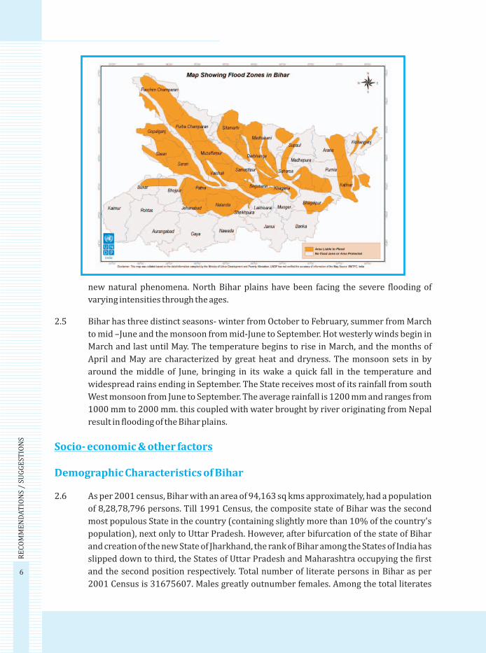
new natural phenomena. North Bihar plains have been facing the severe flooding of
varying intensities through the ages.
2.5 Bihar has three distinct seasons- winter from October to February, summer from March
to mid –June and the monsoon from mid-June to September. Hot westerly winds begin in
March and last until May. The temperature begins to rise in March, and the months of
April and May are characterized by great heat and dryness. The monsoon sets in by
around the middle of June, bringing in its wake a quick fall in the temperature and
widespread rains ending in September. The State receives most of its rainfall from south
West monsoon from June to September. The average rainfall is 1200 mm and ranges from
1000 mm to 2000 mm. this coupled with water brought by river originating from Nepal
result in flooding of the Bihar plains.
2.6 As per 2001 census, Bihar with an area of 94,163 sq kms approximately, had a population
of 8,28,78,796 persons. Till 1991 Census, the composite state of Bihar was the second
most populous State in the country (containing slightly more than 10% of the country's
population), next only to Uttar Pradesh. However, after bifurcation of the state of Bihar
and creation of the new State of Jharkhand, the rank of Bihar among the States of India has
slipped down to third, the States of Uttar Pradesh and Maharashtra occupying the first
and the second position respectively. Total number of literate persons in Bihar as per
2001 Census is 31675607. Males greatly outnumber females. Among the total literates
Socio- economic & other factors
Demographic Characteristics of Bihar
6
RE
CO
MM
EN
DA
TIO
NS
/ SU
GG
EST
ION
S
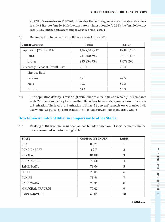
Characteristics India Bihar
Population (2001)- Total 1,027,015,247 82,878,796
Rural 741,660,293 74,199,596
Urban 285,354,954 8,679,200
Percentage Decadal Growth Rate 21.34 28.43
Literacy Rate
Persons 65.3 47.5
Male 75.8 60.3
Female 54.1 33.5
20978955 are males and 10696652 females, that is to say, for every 2 literate males there
is only 1 literate female. Male literacy rate is almost double (60.32) the female literacy
rate (33.57) in the State according to Census of India 2001.
2.7 Demographic Characteristics of Bihar vis-a vis India, 2001.
2.8 The population density is much higher in Bihar than in India as a whole (497 compared
with 273 persons per sq km). Further Bihar has been undergoing a slow process of
urbanization. The level of urbanization in Bihar (13 percent) is much lower than for India
as a whole (26 percent). The sex ratio in Bihar is also lower than in India as a whole.
2.9 Ranking of Bihar on the basis of a Composite index based on 13 socio-economic indica-
tors is presented in the following Table:
Development Index of Bihar in comparison to other States
STATE COMPOSITE INDEX RANK
GOA 83.71 1
PONDICHERRY 82.7 2
KERALA 81.88 3
CHANDIGARH 79.68 4
TAMIL NADU 78.06 5
DELHI 78.01 6
PUNJAB 73.88 7
KARNATAKA 70.31 8
HIMACHAL PRADESH 70.02 9
LAKSHADWEEP 69.81 10
Contd. .....
7
VULNERABILITY OF BIHAR TO FLOODS
VU
LN
ER
AB
ILIT
Y O
F B
IHA
R T
O F
LO
OD

Source : Population Commission, 2002
STATE COMPOSITE INDEX RANK
MIZORAM 69.24 11
DAMAN & DIU 68.95 12
HARAYANA 66.8 13
MAHARASTHA 65.58 14
GUJRARAT 65.22 15
ANDHRA PRADESH 65.13 16
TRIPURA 64.17 17
ANDAMAN & NICOBAR 63.89 18
UTTARANCHAL 60.52 19
WEST BENGAL 59.58 20
SIKKIM 58.64 21
ASSAM 56.35 22
CHHATISGARH 55.44 23
ORRISA 55.40 24
MANIPUR 54.01 25
DADRA & NAGAR HAVELI 51.97 26
MEGALAYA 50.51 27
MADHYA PRADESH 49.33 28
NAGALAND 48.31 29
UTTAR PRADESH 44.09 30
ARUNACHAL PRADESH 43.58 31
RAJASTHAN 43.39 32
BIHAR 39.01 33
JHARKHAND 38.27 34
Contd. .....
The table clearly shows that Bihar ranks very low at 33 out of 34 States. The only State
below Bihar is Jharkhand; erstwhile part of the State.
2.10 Bihar is predominately an agricultural State with about 90 percent of the population
living in rural areas according to the 2001 census. Bihar is a rich agricultural area,
Economy
8
RE
CO
MM
EN
DA
TIO
NS
/ SU
GG
EST
ION
S

crossed by the Ganges River. Bihar can be easily described as a fertile alluvial plain
occupying the Gangetic Valley. The plain extends from the foothills of the Himalayas in the
north to a few miles south of the river Ganges as it flows through the State from the west
to the east. Rich farmland and lush orchards extend throughout the State. Bihar grows
Kharif and Rabi crops and the major agricultural products include rice, bajra, maize,
jowar, sugarcane, tur, potato and pulses. The main cash crops are sugarcane, potato,
tobacco, oil seeds, onion and jute and mesta. Kharif and rabi food grains constitute 64 and
36 percent of the total production of food grains in the State, respectively. The principal
fruits are: mangoes, banana, jack fruit and litchis. This is one of the very few areas outside
China which produces litchi in abundance. Despite its agricultural wealth, Bihar is India's
poorest State, with high illiteracy and infant mortality rates.
2.11 Bihar is richly endowed with water resources, both the ground water resource and the
surface water resource. Not only by rainfall but it has considerable water supply from the
rivers which flow within the territory of the State. Ganga is the main river which is joined
by tributaries with their sources in the Himalayas. Some of them are Saryu (Ghaghra),
Gandak, Budhi Gandak, Bagmati, Kamla-Balan and Mahananda. There are some other
rivers that start from the platue area and meet in the Ganges or its tributries after flowing
towards north. Some of them are Sone, Uttari Koyal, Punpun, Panchane and Karmnasha.
These rivers make the water available for irrigation purpose and also help in generating
the hydro-thermal energy for the State. Apart from this they provide a medium for water
transport, provide fishes for fishery industry and enrich the natural resources of state in
many other ways.
2.12 Nearly 43 percent people of Bihar live below poverty line, as against national average of
26 percent. It shows that the economic condition of Bihar is very poor The absolute level
of poverty continues to be high in Bihar, making it one of India's poorest States. Both,
rural poverty ratio at 41% and urban poverty ratio at 24.7% are significantly higher than
the national average (26.3% for rural; 12% for urban). The level of rural poverty varies
widely across regions and sectors in the State, North Bihar is significantly poorer than
South Bihar.
2.13 The underemployment in rural Bihar is very high as compared to the national average.
Out-migration is a crucial survival strategy for the rural poor in Bihar. Bihar has the
highest rate of gross inter-State out-migration in India. The wage employment in
agricultural labour accounts for nearly 40% of the rural workforce in Bihar. Agricultural
labour and cultivation together account for around 80% of occupations in Bihar. There is
still very limited occupational opportunity outside the agricultural sector in rural Bihar.
Poverty
Unemployment
9
VULNERABILITY OF BIHAR TO FLOODS
VU
LN
ER
AB
ILIT
Y O
F B
IHA
R T
O F
LO
OD
The poor are far more likely to be agricultural wage workers or casual non-farm laborers,
rather than cultivators employed in a regular non-farm job. Self-employment activities
include a wide variety of occupations that could be as vulnerable as casual labour,
especially for the poor.
2.14 In urban areas more than 40% of households are self-employed and around 30% have
regular employment while casual wage labour represents only around 10% of occupa-
tions among all urban households.
2.15 The poor and socially disadvantaged households tend to own low-quality live- stock
(goats rather than cows and buffaloes). Social or caste characteristics are associated with
constraints and lack of opportunities in the State. The caste identity is a strong indicator
of poor in the State.
2.16 In Bihar, the SC/ST are reported to be around three times poorer than the upper castes,
and appreciably poorer than other backward castes and muslims.
2.17 Societal analyses focus on determining the vulnerability of people of different ages,
income levels, education, capabilities, and experiences to a hazard or group of hazards.
Vulnerable populations are typically those who are below poverty line. High density of
population below poverty line in vulnerable areas increase physical exposure and hence
the vulnerability. Income analysis of the population in the State is important because it is
one of the most important indicators of poverty and consequent vulnerability.
As we have seen flood in Bihar is an annual phenome-
non. There is hardly any year which does not witness flood in the State. The State has witnessed
some major floods in the last 50-60 years.
2.18 History of major Flood in Bihar:
1954 Floods: Talk to any elderly person in North Bihar and he would tell you something
about the devastation caused in the floods of 1954.This flood was limited to North Bihar
only with an affected area of 2.46 MH and a population of 7.61 million (out of 18.393
million). This flood had affected 8119 villages (out of 21,107 villages) of North Bihar
leading to the loss of standing crops over 15.96 lakh hectares, about 1,79,451 houses
were destroyed and 63 persons lost their lives in this flood. 1944 cattle had also perished
in this flood. The composite flood loss was estimated at Rs 50 Crores.
1974 Floods: The impact of this year's flood was felt south of the Ganga also in the
districts of Munger and Santhal Parganas and had a spread area of 3.182 MH. It had hit a
population of 16.39 million and crops over 1.751 MH were lost. 5,16,353 houses were
destroyed in this flood that killed 80 persons and 288 cattle. The total losses were put at
Rs. 354.59 Crores.
Floods - a familiar story in Bihar –
10
RE
CO
MM
EN
DA
TIO
NS
/ SU
GG
EST
ION
S
11
VULNERABILITY OF BIHAR TO FLOODS
VU
LN
ER
AB
ILIT
Y O
F B
IHA
R T
O F
LO
OD
1987 Floods: This was the worst recorded flood of the 20th century. The records set by
that flood have not been broken so far (2007 included). This flood had not only mauled
North Bihar, its impact was felt in South Bihar as well as Jharkhand (it was a part of Bihar
those days) also. An area of 4.668 million hectare of present day Bihar and a population of
282.38 lakhs was hit by the flood that had engulfed 23,852 villages and destroyed crops
over an area of 2.51MH. It further destroyed 16,82,059 houses killing 1373 persons. The
rains that started on the 11th August continued almost non-stop till 19th August and no
food packets could be dropped in flood affected districts of Madhubani, Darbhanga,
Samastipur and Khagaria for about 3 weeks despite deployment of 13 helicopters and 58
Army boats. Blocks like Alauli and Beldaur remained marooned till the end of October.
The floods repeated five spells and its gravity can be ascertained from the fact that
Jhanjharpur Sub-division of Madhubani was inundated even after Diwali.
2004 Floods: This year's flood was spread over 20 districts of North Bihar with an area
over 2.772 MH ( 4.99 mh according to CWC) and affected population of 21.3 million. This
flood had engulfed 9346 villages, destroyed crops over an area of 1.399 MH and swept
away 9, 29,773 houses killing 885 persons.
2007 Floods: The floods in Bihar during the South West Monsoon 2007 (July to
September 2007) portray yet another familiar picture of the states vulnerability to
recurrent floods and is a grim reminder of the extensive devastations destruction and
disruption caused by the floods. The South west monsoon has become a synonyms of
floods in North Bihar districts which bring untold human miseries and sufferings to the
people who have been cursed to live in abject poverty for generations, struggle for
subsistence and get caught in the whirlwind of floods, poverty and indebt ness. The
floods 2007 in the State has been designated as unprecedented in its intensity; unpredict-
ability; unseasonality in its timing; its spatial coverage; its successive spells and its
extended duration.
The magnitude, intensity and frequency of Bihar floods 2007 may be unprecedented but
the State has been bearing the brunt of floods since time immemorial. More so, it is
considered as one of the main causes for putting the State at the bottom of the develop-
ment index of the country. The poor are always the most adversely affected in any disaster
situation and recurrent floods in the State are no exception. Poverty and inequality that
prevails in the State has further been accentuated by recurrent floods which are a grim
reminder of the fact that the flood control measures undertaken by the Government has
miserably failed. The question arises as to whether the flood control and flood manage-
ment measures in the State are on the right track or whether there is an urgent need to
have a comprehensive re-look at the whole gamut of flood control and management. In
the year 2007, it is reported that in Bihar, around 20 Million persons and 0.60 Million
animal have been affected. The affected area is approximately 0.18 Million ha with 0.17
Million ha. agriculture land and 0.07 Million ha non-agricultural. The total crop loss

12
RE
CO
MM
EN
DA
TIO
NS
/ SU
GG
EST
ION
S
estimated is worth Rs. 300 Million. The flooded water aggravated public health risk in the
entire area and the people had to suffer in want of medical treatment. Subsequently
epidemic in forms of diarrhea, jaundice & influenza engulfed in the entire flood affected
pockets of Bihar.

13
CHAPTER - 3F
LO
OD
S IN B
IHA
R 2
00
7
FLOODS IN BIHAR 2007
Genesis of the floods 2007
3.1 Facing the tormenting floods had been trying for the people. However, its aftermath could
have been even more difficult. Livelihoods of many, especially the poor, might have
remained lost for days and months to come. Also, as the water recedes, the consequent
health hazards can pose greater danger. Lost houses can render the affected population
homeless and living in shelters for a longer period. Damaged roads, bridges, and schools,
to name a few, may limit the possibilities of getting back to normal rhythm of life. Fully
cognizant of these implications, the state government worked on all such fronts to see to
it that these disrupting factors were overcome as quickly as possible, and people got help
and empowered to reconnect to their normal lives.
3.2 The floods in Bihar during the South West Monsoon 2007 (July to September 2007)
portray yet another familiar picture of the State's vulnerability to recurrent floods and is
a grim reminder of the extensive devastations destruction and disruption caused by
floods. The South west monsoon has become a synonyms of floods in North Bihar
districts which bring untold human miseries and sufferings to the people who have been
cursed to live in abject poverty for generations, struggle for subsistence and get caught in
the whirlwind of floods, poverty and indebtedness.
3.3 The recurrence of floods in Bihar every year with varying intensity has been a perennial
problem. However, the floods of 2007 make a break from the past in terms of;
Its intensity;
Its unpredictability;
Its Unseasonality -in its timing;
Its spatial coverage;
Its successive bouts;
3.4 In 2007, about twenty days
of incessant rains, 300 to
400 % over and above
normal trends in second
half of July, had been
unprecedented. This was
again repeated in August
and simultaneously, heavy
rain-fall in the upper

14
FLOODS IN BIHAR 2007
BIH
AR
FL
OO
D R
EP
OR
T -
20
07
catchments areas of Nepal compounded the problem and its consequences. Indian
Meteorological Department's official data set for 1 July to 22 August 2007, provides
disaggregated figures of rainfall for severely flood hit districts, which demonstrates that
district wise picture is even worse. The Central Water Commission's data showed that,
the water level of many rivers rose sharply during the second half of July 2007, and in
many cases went up 2-3 meters, or even higher, well above the danger mark. This perilous
situation continued for about six days in July and about 15 days in August, thus almost for
21 days at a stretch. While it receded and came close to the danger level by 16 August,
however, it again rose since then and went up to about 2 meters above the danger level,
which had resulted from a second spell of heavy downpour that Bihar once again
unexpectedly witnessed towards middle of August to add to its miseries.
3.5 According to the media report,
nearly 20 million people got
affected during 2007 floods which
is considered as one of the worst
floods in Bihar in a decade. The
flood during the year showed no
signs of abating and prolonged for
a considerable long time. As per
State Government 510 persons lost
their lives in the floods. The flood affected 17 out of 36 districts in the State. The overall
flood situation in Bihar continued to be grim for more than 2 months severely affecting
about 69 lakh people in 110 blocks of the 14 districts of the State which were worst
affected by the deluge. The worst affected districts were Muzaffarpur, Sitamarhi, Saharsa,
East Champaran, Darbhanga, Patna, Supaul, Bhagalpur, West Champaran, Katihar,
Madhubani, Samastipur, Sheohar and Nalanda. According to State Water Resources
department sources, swollen rivers breached their embankment at many places inundat-
ing vast areas in the worst affected districts particularly Muzaffarpur, Sitamarhi, Saharsa,
East Champaran, West Champaran Darbhanga, Samastipur and Begusarai.
3.6 Apart from causing death of 510 human lives, the floods caused extensive damages to
agricultural crop human habitation and infrastructure sector. Some of these are summa-
rized below:
Breaches: 32 points totaling 5130 meters in length, in almost all protection > embank-
ments of various major rivers. Huge number of minor river embankments, canal system,
sluice gates too have also been damaged.
Impact
The Damage

15
FL
OO
DS IN
BIH
AR
20
07
Extent of flood inundation: 20 districts mostly of North Bihar; 225 Blocks, covering
9,939 villages.
Persons and families affected: 20 million people; roughly about 5-6 million families.
Crop losses: 1.64 million hectares, leading to a loss of various crops of the value of about
Rs 113.6 billion.
House damages: 5.12 lakh houses (mostly kuchcha) causing a loss of about Rs. 5585.18
million.
Lives lost: 510 (including 47 deaths due to boat mishaps).
Animals affected: 1.12 million; 559 dead
Agriculture: This mainstay of Bihar's economy has been severely damaged. Thus Kharif
crops in 1.64 million hectare land have been damaged. Additionally 0.25 million hectares
under sugarcane plantation have also been damaged. There is extensive damage to other
perennial and horticultural activity like Banana, Litchies, Mangoes and Vegetables.
Coupled with massive losses of seedlings of various crops for coming Rabi season, the
estimated loss in this sector is to the tune of Rs. 113600 million, or Rs. 113.6 billion.
Roads: 480 Kms of National Highways and 36 nos. Bridges and culverts of NHs have been
damaged. Road embankments have been breached at 54 points. One bridge has been
washed away on NH-105. Important State Highways and major District Roads have been
extensively and severely damaged, covering a length of 782.00 Km. Over 66 cross
drainage work also need repair and restoration.
Rural Roads: Out of total road length in flood affected area of 7965.28 km, a total of
3193.57 km have been damaged which accounts for 34.78%. Further, 1353 number of
bridges and culverts are also damaged.
PHED: The rural and urban piped water supply system, and numerous hand pumps have
been damaged, requiring about Rs. 630 million for their immediate restoration.
3.7 During the visit of NIDM Team a
spokesman of the Disaster
M a n a g e m e n t D e p a r t m e n t
reported that over 1.25 crore
people have been reeling under
the impact of the floods. The
Central Water Commission said
Bagmati, Burhi Gandak, Kamla
Balan, Adhwara, Kosi and

Mahananda rivers were flowing above
the red mark at various places, while the
Ganga crossed the danger mark for the
first time at Farakka. The flood situation
worsened with major rivers including
Burhi Gandak, Gandak, Bagmati,
Mahananda and Kosi, flowing above the
danger level, following heavy rains in
their catchment's areas. According to a
Central Water Commission report, Burhi
Gandak was flowing 155 cm, 139 cm, 237
cm, 259 cm and 14 cm above the danger mark at Lalbegia ghat, Sikandarpur, Samastipur,
Rosera and Khagaria respectively. Bagmati was 116 cm and 274 cm above the red level at
Benibad and Hayaghat. Kamla Balan was above the danger mark by 146 cm at Kamtaul,
223 cm at Ekmighat and 23 cm at Jhanjharpur, while Kosi was flowing 175 cm, 17 cm and
8 cm above the red mark at Baltara, Basua and Kursela, it said. The Ganga too was flowing
41 cm above the red mark at Sahebganj, while Gandak crossed the danger level at Chakia
by 45 cm.
3.8 1722 boats were pressed into service to evacuate the stranded people. Around 121 relief
camps, 24 veterinary camps and 47
medical teams were functioning round-
the-clock to provide succor to the
affected people. Over 400,000 people
were reportedly marooned by flood-
waters and were living on rooftops,
railway tracks and river embankments
without adequate food and drinking
water. With no power or telephone lines
in most flood-hit areas communication
with the rest of the State was cut off
however mobile phones worked.
Although surrounded by water, most
flood victims had no access to safe
drinking water.
3.9 It was observed that community
initiatives had been able to provide only
meager help to villagers. In some areas,
locals stayed perched on rooftops and
trees for days exposed to sun and rains.16
FLOODS IN BIHAR 2007
BIH
AR
FL
OO
D R
EP
OR
T -
20
07

3.10 FIELD VISIT OBSERVATIONS
! About 19 million people in 20 districts were affected, about 450 lives were lost, 867.
171 people were evacuated and No of relief camps setup were 128. It was estimated
that total damages accounted for around Rs. 10 billions.
! In the discussions with public officials it was found that people are good in emer-
gency management but lack motivation and attitude towards a holistic disaster
management approach.
! Response during this year's flood was comparatively good as relief materials, food
items etc. were distributed with in the first 24 hrs. in most of the cases.
! There were no Standard Operating Procedures followed for flood response Plans
were designed and executed on the basis of day-to-day emerging needs. Again, there
was no standard response plan formulated for handling the flood situation.
! Air dropping of relief and food materials was carried out on the basis of topographic
details of the villages.
! Issues of rehabilitation, water and sanitation and social security came out strongly
which require due attention.
! Huge damage to health infrastructure viz. health centres, dispensary, etc.
Approximately 235 public health centres were fully damaged.
! About 500 livestock perished in the floods. It was observed that for the purpose of
animal evacuation the concerned department had issued instruction to all its field
offices, centers, and animal hospitals for better preparation.
! District Disaster Management Plan though available in districts was not put in to use.
! Bihar Institute of Public Administration and Rural Development (BIPARD) Centre for
Disaster Management had set up a Unified Command Centre to tackle the flood
situation. A Unified control room was also setup and core group of 7-10 NGOs and
other organizations were involved in the post flood management activities. This
mechanism of co-ordination between Govt. and Non-Government organizations
worked well.
! It was found that during the floods in 2004, Hume pipes were constructed which got
broken and led to congestion in water flow through these channels was one reason
for this years flooding. Many roads were blocked because the flood water got
circulated and led to drainage problem.
! Poor and socially marginalized people were found to be the worst sufferers and there
was an increase in migration rate as people migrated to towns / cities in search of
employment as explained by them. 17
FL
OO
DS IN
BIH
AR
20
07

!
rather than relief efforts only year after year.
! A strong need was felt for an efficient water distribution and preservation system
which must be established. Efficient water-shed management is the need of the hour.
! The rain - fall pattern had changed and Bihar received most of its intense rain fall in
mid July within 10 to 15 days. Natural flows of most of the rivers in Bihar have got
choked on various accounts.
! Due to road construction natural drainage pattern disturbed which led to water
congestion and subsequent flooding.
! From the health view point, it was assumed that heath issues were same as during
other flood situations but, differed in severity and impact. This time prolonged
severity was expected along with threat of epidemics spread.
! Embankment work in Bagmati River was still ongoing. The very heavy precipitation
within a short period led to siltation and water retention and is attributed as one of
the major causes of floods. No de-siltation initiatives were considered as part of a
pre-monsoon flood management planning.
! People in the affected districts have become used to the hardships caused by floods
however this year the successive bouts of floods over extended period added to their
miseries.
! Loss of human lives was less as compared to other major flood in and most of the
mishaps were due to accidents like boat capsize than due to flooding.
! Most of the schools and colleges which can be used as temporary shelters during
flood situations have been constructed on low lying areas with poor road connectiv-
ity and therefore were of not much use.
! Sanitation for women is a major issue which is generally neglected by local adminis-
tration.
! Supply of adequate of polythene sheets was a cumbersome task in many districts.
! Reaching of relief materials to marooned villages was a difficult task as road commu-
nication was distracted.
! In Begusarai district, ICS was applied to a limited extent from 16 September 2007
onwards whereby a separate logistic, operation (district relief centre), and media
sections were set up. These sections worked under delegated powers and were
engaged in sending relief materials, boats, providing man power etc. Briefing by the
District Collector was taken every day at a stipulated time. The improvisation
worked satisfactorily and was found an effective tool. A need was felt to have a
separate Security and Health section as well.
Affected Community wants a permanents solution to the recurring floods issues
18
FLOODS IN BIHAR 2007
BIH
AR
FL
OO
D R
EP
OR
T -
20
07

19
FL
OO
DS IN
BIH
AR
20
07
Inter-agency coordination meeting at BIPARD
3.11 A number of Non-Government organizations presented their field efforts. The major
issues that came up during the inter-agency meeting are as under:
! Focus should be given to inaccessible villages.
! Health concerns of marooned villagers be addressed.
! Flood management efforts should not become a one organization show and credit
should got all organizations involved.
! It was found that many of the organizations involved were working slowly and
should have been more active.
! Duties for each organization should be well marked/demarcated so as to avoid
duplication in relief efforts with good facilitation efforts.
Year
PERMANENT LOSS OF LIFE AND PROPERTYDUE TO FLOOD FLOOD AFFECTED AREA & POPULATION
Human AnimalCrop
Damaged(Rs Lac)
HouseDamagedValue (inRs Lac)
PublicProperty
Damaged (inRs Lac)
VillagePopulation
(in LacNo.)
Animal(in Lac
No.)
Land inLakh Ha.
Houses(Nos.)
cou
rtes
y: r
epo
rt o
f D
isas
ter
Man
agem
ent
Go
vt. o
f B
ihar
2007 (24/9/2007)
2006
2005
2004
2003
2002
2001
2000
1999
1998
1997
1996
1995
1994
1993
1992
1991
1990
1989
1988
1987
1986
36
58
885
251
489
231
3336
243
381
163
222
291
91
105
4
56
36
26
52
1399
134
31
4
3272
108
1450
565
2568
136
187
151
171
3742
35
420
84
76
29
5302
511
706.63
1,164.50
52,205.64
6,266.13
51,149.61
26,721.79
8,303.70
24,203.88
36,696.68
5,737.66
7,169.29
19,514.32
5,616.33
13,950.17
58.09
2,361.03
1,818.88
704.88
4,986.32
67,881.00
10,513.51
1,225.03
382.79
75,809.51
2,032.10
52,621.51
17,358.44
20,933.82
5,384.95
5,503.70
3,056.67
1,495.34
7,510.44
494.77
8,814.00
16.14
613.79
160.12
160.73
211.32
25,789.32
647.24
8,456.17
305
1,03.049.60
1,035.16
40.892.19
18,353.78
3,780.66
5,409.99
9,284.04
2,038.09
1,035.70
2,183.57
151.66
3,040.86
0.75
139.93
182.27
83.7
150.64
680.86
3,201.99
959
1,464
9,346
5,077
8,318
6,405
12,351
5,057
8,347
7,043
6,417
8,233
2,755
3,422
414
4,096
4,178
1,821
5,687
24,518
6,509
10.89
21.04
212.99
76.02
160.18
90.91
90.18
65.66
134.7
69.65
67.33
66.9
40.12
53.52
5.56
48.23
39.57
18.79
62.34
286.62
75.8
0.1
5.35
86.86
11.96
52.51
11.7
8.09
13.58
30.93
10.11
6.6
8.15
15.03
6.68
0.75
5.13
2.7
0.35
0.21
33.25
*
1.81
4.6
27.00
15.08
19.69
11.95
8.05
8.45
25.12
14.71
11.89
9.26
6.32
15.64
0.76
9.8
8.73
4.71
10.52
47.5
19.18
18,637
5,538
9,29,773
45,62
4,19,014
2,22,074
3,43,091
91,813
1,99,611
1,74,379
1,16,194
2,97,765
33,876
2,19,826
1,281
27,324
11,009
7,746
14,759
17,04,999
1,36,774
852 1,28,443.51 84,222.98 – 10,848 226.37 – 17.56 6,70,398

Breach of embankment as observed in Begusarai District
Breach of embankment at District Begusarai during floods in 2007
Clockwise from top: women expressing their griefs at a temporary shelter; people staying a relief camp; relief material distribution and single housing
shelter per family at a relief camp20
FLOODS IN BIHAR 2007
BIH
AR
FL
OO
D R
EP
OR
T -
20
07

Relief and Response Measures
3.12 The floods 2007 were indeed devastating as it badly affected 20 districts. About 20.5
million people, or approximately 5-6 million families, in these districts were badly
affected. The poor people in particular whose thatched and mud houses, usually located
in the low lying areas of the villages, were the most affected as their dwelling units got
almost demolished.
3.13 State Response: The State government mounted an all out effort to meet this challenge
on a war footing. Working day and night, the officials were utilising all possible means to
reach the flood affected families and provide them relief. The following were some of the
immediate relief measures taken by the State in order provide succor to the affected
people.
3.14 Deployment of Boats: About 7000 boats were deployed for rescue of stranded people,
providing communication and also distributing relief materials. A number of districts,
such as Motihari, Muzaffarpur, Bettiah, where local boats either fell short of demand, or
were incapable to ply in the strong currents of flood water, truckloads of stronger
midsized boats were transported from Vaishali and Bhojpur districts to overcome these
limitations.
3.15 Air force Choppers and Army Boats: A number of critical areas, that were difficult to
reach by boats, were served by dropping off of food packets with the help of four Air Force
choppers for about nineteen days, dropping about 71,000 food packets, weighing in total
355 tones. Twenty (20) army boats had been pressed into action in 3 districts to ensure
distribution of relief materials to the marooned villages.
3.16 Dry Rations: About 10,559 quintals
of dry ration food (chura, sattu,
jaggery, salt, etc.) were distributed.
In many places people were addi-
tionally being provided with cooked
food as well. Along with the dry
ration, about 2,00,000 pieces of
candle and 150334 matches had
also been distributed.
3.17 Cash: Rs. 32.31 crore was distrib-
uted in cash till compilation of this report.
3.18 Polythene Sheets: About 2,36,000 polythene sheets had been distributed. Additional 1
lakh polythene sheets were supplied to help in setting up temporary shelter. 21
FL
OO
DS IN
BIH
AR
20
07

3.19 Drinking Water: 126 tube wells had been dug on embankments and other places of
temporary shelter to people. Help was even sought from the GE water infrastructure,
which provided with their gen-set operated water purifier machines, having a capacity of
purifying 1500 liters of water per hour.
3.20 Food grain: The most critical problem, on account of prolonged floods was of food needs
of affected people. The government ensured that it was mitigated to a considerable level
by providing 1 quintal of wheat and rice per family. This was decided by the CRF commit-
tee in Bihar, and was being ensured in right earnest, leaving none who have undergone
the sufferings in the floods. About 5,80,000 quintals of wheat and rice had been distrib-
uted. While the Central Government was requested for an allotment of food grain under
relief head, the State Government went ahead with the available food grain stock, since
this had to take primacy over everything else. However, the first tranche of the Center's
allotment of 10 lakh quintals rice and 5 lakh quintals wheat was already made. A massive
coordination between FCI and SFC, as well as district administration, had been worked
out through a meticulous forward and backward planning, to ensure that about 600 to
700 trucks, carrying about 55,000-60,000 quintals of food grain per day, deliver wheat
and rice to the affected families in 20 districts, so as to ensure that the distribution was
not lingered on for long.
3.21 Housing: This was the second biggest need of the poor, who suffer the most on this count.
Rs. 10,000 for fully damaged kuccha houses, and other related norms under the CRF
would allow in mitigating this problem to an extent. However, the State government
proposed that these houses be redone with pucca construction using Indira Aaawas
scheme for natural calamity victims. The survey of destroyed and damaged houses had
already begun till compilation of this report.
3.22 Health: Experiences abound that in the aftermath of a massive flood, peoples' sufferings
can increase manifold. Heath Department was actively working on this, by ensuring a
wide scale campaign for disinfection. Treatment and provisions of medicines for diseases
likely to occur, diarrhea, skin infections etc. were made by the Government. UNICEF was
also supplementing the efforts of the State Government.
3.23 State support to the Farmers: Considering the massive scale of crop loss in about 16
lakh hectares this year, the State had decided to provide Rs. 2000 per hectare additional
support, over and above Rs 2000 per hectare provided under the CRF norms, to the small
and marginal farmers. The State government had further taken a major decision to
provide Rs 6000 additional support to other farmers, over and above Rs. 2000 per
hectare provided under the latest CRF norms (up to a ceiling of 1 hectare).
3.24 Banks' involvement: It was decided to stop all loan recovery in the flood affected areas,
reschedule them, and further provide consumption loan at a very soft interest rate, and
also fresh crop loans, to help farmers to move on to alternative cropping and rabi farming.
22
FLOODS IN BIHAR 2007
BIH
AR
FL
OO
D R
EP
OR
T -
20
07

3.25 Coordinating Emergency Response
and Relief Operations: The Disaster
Management Department had been
working continuously to ensure
effective coordination and synergy of
efforts between multiple sectoral
departments, district administration,
the Army and the Air force, and the
NGOs. Timely resource allocation to
different departments and field units
resulted in allotments to the tune of
Rs. 250 crores under different heads of relief. This was the highest resource allocation
ever done for flood relief operations in Bihar, using State's own exchequer. All concerned
line departments such as Health, PHED, Irrigation, Roads, Animal Husbandry and others
worked to ensure emergency responses in their sectors despite heavy odds.
3.26 Govt. and Non – Govt. partnership: The Disaster Management Department had
initiated massive coordination with a number of NGOs, civil society groups and the like,
working with Oxfam, UNICEF, USAID, Action aid, CARE India, DFID's PACS, Adithi, YMCA,
NYK and many others. It further went on to evolve to pool manpower, logistical support,
survey and assessment operation, and feedback and surveillance to ensure speedy,
transparent, and effective distribution of relief.
3.27 Village Volunteers raised under Bihar DRM Program: 14 districts of Bihar are
covered under the UNDP-GoI DRM Program. 5,000 volunteers in about 500 villages were
raised before the floods through a participatory process. Further, they were trained in
search and rescue and first aid by a National Disaster Response Force (NDRF). Many of
the villages out of this cluster were affected by the flood. These volunteers were found
effective service in rescuing and evacuating people, and also in supervising the relief
distribution in their villages.
3.28 The State sought Central Government's assistance for short, medium and long term
measure to address present distress, effect timely rehabilitation by restoring livelihood
and income measures. The assistance sought by the State mainly include the following: -
3.29 Short Term Measures:
A. Cash Support: Cash needs to be provided under the CRF at the rate of Rs. 20 per adult
and Rs. 15 per child for meeting the needs of food for the affected people, who lost
their food items etc., or were unable to get it ready due to other hardships. 204 lakh thpersons have been reportedly affected until 28 August 2007 assuming a ratio of three
adult and two children in the population, this cash need comes to Rs. 1105 crores.
Assistance from the Central Government
23
FL
OO
DS IN
BIH
AR
20
07

B. Evacuation, and other costs: The cost of plying of boats, food dropping operations
through air force helicopters, deployment of army boats, purchase of polythene
sheets, ex-gratia payments to the families of those who died due to floods, other
related items, which are all admissible under the CRF norms, have been assessed to
be in the range of 100 crores
C. Food Grain Support: As stated above, about 20.4 million people had been affected
which would roughly mean that 5-6 million families require the relief support. Taking
the higher figure of 6 million families, 60 lakh quintals of wheat and rice were provided
under the relief head to FCI. An assistance of Rs. 945 crore to purchase the required 60
lakh quintals in total (in the ratio of 75% rice and 25%) was made by the State.
3.30 Medium Term Measures:
A. Agriculture: The Flood in 2007 has had an all round serious adverse impact in the
agriculture sector of Bihar, damaging kharif crops extensively, as well as sugarcane
plantations, and seeds for rabi. The floods came at a time when the State was poising
for a major jump in productivity, through higher consumption of fertilizer and
improved seed replacement ratio. This year flood has been more devastating for
agriculture because of its timing and duration, which coincided with transplantation
and establishment of paddy crop in the main field. A total of Rs. 362.33 crores was
sought by the State Government towards agriculture input subsidy. The State
Government reported a total damage of Rs. 1136 crores in the agriculture sector on
account of crop damage and rabi seed damage due to floods.
Department of Agriculture has assessed the following assistance under CRF on the
available figures of crop losses in area % where such losses are 50 % or more.
B. Restoration of Embankments: The floods breached embankments at 32 points and
their immediate restoration along with those required to restore the embankments
of minor rivers. On the basis of costs incurred on flood fighting and assessment made
for restoration of sluices and damaged canal systems, the State Government pro-
jected a requirement of Rs. 521.72 crores.
3.31 House Repair: Rural poor, mostly live in
the kuchha houses in the comparatively
low lying areas in their villages, and bear
the maximum brunt of floods by way of
loosing their homesteads. With that they
also lose their household utensils,
clothing, children's educational resources,
and other belongings. The State
Government estimated that about 6.0 lakh 24
FLOODS IN BIHAR 2007
BIH
AR
FL
OO
D R
EP
OR
T -
20
07
houses had been destroyed. The CRF norms provide Rs. 10,000 assistance for fully
damaged Kuccha houses and Rs. 25,000 for pucca houses. It is roughly estimated that of
the estimated likely 6 lakh houses damaged, 20% of it will be pucca houses. Thus, the
assistance needed for such 1.2 lakh damaged pucca houses would be around Rs. 300
crores. The rest 80%, i.e. 4.8 lakh kutcha houses, will require an assistance of Rs. 480
crores. This will add up to Rs. 780 crores. However, in case of particularly the kutcha
houses, the assistance of Rs. 10,000 per house will be both inadequate and also not
provide a durable housing solution to the poor. Since there is already a program running
under the rural development ministry of the GOI for providing Indira Awaas to the victims
of natural calamities, it was considered to be of great value if Rs. 25,000 per Indira Awaas
unit is dovetail with Rs. 10,000 assistance under the CRF, to make it possible to have a
durable pucca construction of houses for the concerned flood affected rural poor.
3.32 In total, therefore, the State Government sought an assistance of Rupees 1980 crore, out
of which Rs. 780 crore would come from CRF, and the rest Rs. 1200 crore from the existing
scheme of IAY for the natural calamity victims. This will go a long way in offering a
durable and dignified housing solution to the flood hit rural poor, and also containing the
recurring CRF expenditure on this count.
3.33 Highways and Rural Roads: The unprecedented floods also caused heavy damages to
National highways, State highways and large network of rural roads. Over topping of
these roads at various points had led to erosion of crusts, breaches and other damages in
several kilometers. Besides, a number of bridges and culverts had been extensively
damaged; in some cases even washed off. The technical estimation by the road construc-
tion department as well as the REO looking after the rural roads had estimated the cost
for immediate restoration of these commutation links. The costs, as assessed by the RCD
department was of Rs. 1586.10 crores.
3.34 Other Sectors: PHED assessed that damage to its rural piped water schemes, hand
pumps, and other related works would need assistance of Rs. 63.44 crore. The Minor
Irrigation Department assessed damages to its lift irrigation and other surface water
schemes, which play an important role in augmenting the irrigation capacity of the State
to the tune of Rs. 203.37crore.
3.35 Consolidated list of financial requirements for floods – 2007: The State Government
submitted a consolidated requirement of financial assistance under Calamity Relief Fund
covering all sectors for urgent repair and restorations of their damaged infrastructures
as well as expenditure already incurred towards relief & rescue etc. amounting to
Rs 8000 crore (Table 3.1)
25
FL
OO
DS IN
BIH
AR
20
07

Sl. Department Amount RequiredNo. (In crores)
1. Disaster Management Department
a. Houses for the poor 1980 crores
b. Cost of Food grain 945.00 crores
c. Cash for ready food 1105.00 crores
d. Rescue and evacuation,Temp shelter, special army/airforce operations, etc = Rs. 100.00 crores
2. Water Resources Department 521.72
3. Department of Health 25.04
4. Department of Animal & Fisheries 111.572
5. Road Construction Department 1586.1
6. Rural Works Department 511.85
7. Bihar State Electricity Board 62.37
8. Public Health & Engineering Department 63.4419
9. Bihar State Food & Civil Supplies Corporation 0.63
10. Department of Agriculture 362.32
11. Building Construction Department 71.198
12. Department of Industries 166.56
13. Bihar Education Project 74.35
14. Department of Social Welfare & SC / ST welfare 8.465
15. Energy Department 0.896
16. Department of Urban Development & Housing 57.6903
17. Human Resource Development Department 6.18
18. Minor water Resources Department 203.37
19. Bihar State Hydro Electric Power Corporation 32.00
GRAND TOTAL 7995.75 or say,Rs. 8000.00 crores
4130.00
Source : Report submitted by Government of Bihar to the Central Team
Table 3.1
26
FLOODS IN BIHAR 2007
BIH
AR
FL
OO
D R
EP
OR
T -
20
07

PAST APPROACHES, ACHIEVEMENTS AND PRESENT PRACTICES
Construction of Flood protection embankments
Irrigation, Water and Flood Management
4.1 Over the last 55 years of plan development, Bihar has been able to provide reasonable flood
protection benefits. According to one estimate, only about 42 per cent of its flood prone area,
has been covered through flood protection embankments. If the State intends to cover most
(over 90%) of its flood prone area by flood protection measures in the next 25 years, flood
protection embankments will have to constructed at the rate of 150 km per year. It was
estimated that during the 10th and subsequent Plan periods an annual plan outlay of Rs. 150
crore (@ Rs. one crore per kilometre) would be needed. Secondly, the condition of existing
embankments is deteriorating day by day. The bed level of rivers is rising every year on
account of situation. The raising and strengthening of embankments, therefore, needed to be
taken on a priority basis. Construction of Pucca road on the existing embankments will
ensure rapid inspection and execution of anti-erosion as well as flood fighting works and
provide all season road communication in rural areas of the State. This will also facilitate
other development works in the area.
4.2 While dealing with the flood problem in North Bihar, focus has by and large has been on
construction of embankments aimed at preventing the flood flows from inundation of the
overlying plains. Experts are of the view that this approach is too simplistic and ignores
vitally related realities. First of all, embankments interfere with the drainage function of a
river which serves as a natural drainage channel for the related catchment area, thus
disturbing the drainage of the area sought to be protected against floods. Secondly, it
disregards a dominant component of the flood flows, i.e., silt transport by the river which
carries more than 90% of the annual silt load during floods. This gives rise to several seri-
ously adverse consequences. Thirdly, embankments progressively become more prone to
overtopping and breaches. This renders the fury of floods more destructive and devastating.
4.3 By the time India got its independence in 1947, there were embankments of a total length
of 5,280 Kms in various river systems providing protection to an area of about 3 Mha.
Since then the problem of flood management was referred to various committees from
time to time. The recommendations of some of the important Committees/Task Forces
constituted by the Government of India are Annex - III.
4.4 The various committees constituted invariably recommended that all irrigation projects
should address flood moderation. Though the whole of Bihar lies in a humid zone with an
annual rainfall of more than 11-1200 mm which is sufficient for kharif crops like paddy
and maize, the occurrence and distribution of rains are highly erratic and distinctly
seasonal in character. The consequences become very severe where paddy which is
CHAPTER - 4
27
PAST
AP
PR
OA
CH
ES, A
CH
IEV
EM
EN
TS A
ND
PR
ESE
NT
PR
AC
TIC
ES
28
PAST APPROACHES, ACHIEVEMENTS AND PRESENT PRACTICES
BIH
AR
FL
OO
D R
EP
OR
T -
20
07
highly sensitive to droughts is the most important crop covering about 66 percent of the
net cropped area. By providing water during lean months, irrigation extends the period
of cultivation beyond monsoon months and facilitates multiple cropping. In addition, it
adds substantially to agricultural output by changing the cropping pattern in favor of
high yielding and superior crops
4.5 The irrigation potential through surface water sources in the State has been assessed at
67.03 lakh hectares (53.53 lakh hectares through major/medium schemes and 10.5 lakh
hectares through minor surface irrigation schemes), while irrigation potential through
groundwater in the state is 39.06 lakh hectares. Thus, taken together both surface and
ground water sources, the ultimate irrigation potential of the State is estimated at 103 lakh
hectares which comes to 7.34 per cent of India's total of 140 million hectares (Table 1). The
total irrigation potential, however, far exceeds its gross sown area of around 80 lakh
hectares and net sown area of 56 lakh hectares. Even if the cropping intensity in the State
rises substantially in future and goes up to 200 percent from the present 143 per cent
(Punjab level being 190 per cent) and the total sown area goes up to 112 lakh hectares, the
ultimate irrigation potential of the State will be sufficient to cover nearly this entire area
4.6 Surface irrigation projects suffer from a number of disabilities. They are mostly rainfed
and are affected by the vagaries of rainfall particularly during periods of prolonged rain
failures. Limited water supplies are mostly appropriated by upper reaches of the
command. The most pertinent case in point is the failure of the canal water to reach the
tail ends of the command in the Sone canal system during the 1979-80 drought. They also
involve large gestation gaps and huge costs in terms of water logging, salinity and gross
wastage of water through seepage and evaporation. Some of the major irrigation
schemes (including Gandak) are not complete fully even after more than 30 years since
inception. The quantum of water logged lands in the command areas of major irrigation
projects in India has been assessed at 1.59 million hectares. In this, the share of Gandak
Project amounts to 0.33 million hectares which comes to about 35 percent of its
culturable command area of 0.96 million hectares. Depending on soil conditions and size
Potential for Irrigation
Source India Bihar % share ofBihar in India
I. Surface Water 737 63.58 8.63
(a) Major + Medium Schemes 585 53.53 9.15
(b) Minor Irrigation 174 10.05 5.78
II. Ground Water 641 39.06 6.09
Total (I + II) 1399 102.64 7.34
Source : Central Water Commission, Dept. of Water Resources, Bihar and Central Ground Water Board.
Table 1 : Ultimate Irrigation Potential in Bihar(in Lakh Hect.)

of the project, the conveyance losses in India vary from 20 to 50 per cent of the water
released at the canal head. These losses come to around 50 per cent in the Gandak project
against projected 30 per cent. Finally, irrigation potential of schemes is often overesti-
mated. The projects have not been properly executed and they are mostly incapable of
carrying their designed discharge. They are also beset with major distributional prob-
lems and exhibit large gaps between their potential and utilization. Thus, as shown in
Table 17, during 2004-05, the actual irrigated area through major/ medium schemes in
the State stood at 14.88 lakh hectares which came to 56.82 per cent of their created
potential (26.19 lakh hectatres).
4.7 A large chunk of capital has been invested in major/medium irrigation projects and they
form a very valuable resource for the development of the State. For making their contri-
bution towards enhanced productivity, the system of operation and maintenance must
be of high quality. However, in absence of fund availability, the systems have deteriorated.
The seventh conference of irrigation ministers of India held on 15.12.1983 recom-
mended a provision of Rs 100 per hectare of the created irrigation potential towards
maintenance and operation grants of surface irrigation projects. At 2000-01 prices, the
required sum would be around Rs. 400 per hectare. During 2000-01 expenditure on this
account came to Rs. 100 per hectare in Bihar against the recommended amount of Rs.
400. Instead of the increased level, the amount spent on the maintenance and repair of
these schemes declined over time though things have changed for the better after 1995-
96. Therefore, the condition of most of these schemes is far from satisfactory and, they
are not in a position to carry more than half of their full designed discharge, even when
there is abundant water in the rivers supporting them.
4.8 As we understand that on account of its geographical location, Bihar is the most flood
prone State of India. Nearly all north Bihar rivers originate from Nepal or Tibbet and have
around 75 per cent of their catchment outside the State, mostly in the Himalayan ranges
which have very high rains aggregating 2500 mm annually in upper portions, of which
over 80 per cent occurs during the four rainy months from June to September. Higher
rainfalls in upper catchments having very steep gradients result in formation of very high
flows in these parts. As the gradients change sharply from very steep in mountainous and
sub-mountainous areas to very mild in north Bihar plains over rather a short distance,
the carrying capacity of the rivers in the plains are far exceeded by the high monsoon
flows, resulting in vast inundations over the plains. A flat area of 21453 sq. miles has to
drain off the rainfall of about 60000 sq miles of the Himalayas and its foothills besides its
own fairly heavy rainfall aggregating 1300 mm annually. The flood situation aggravates
when the Ganga itself is in high spate and Bihar rivers find it difficult to drain in to it
Poor Maintenance and Decay in Water Carrying Capacity:
Flood Control and Drainage
29
PAST
AP
PR
OA
CH
ES, A
CH
IEV
EM
EN
TS A
ND
PR
ESE
NT
PR
AC
TIC
ES

30
PAST APPROACHES, ACHIEVEMENTS AND PRESENT PRACTICES
BIH
AR
FL
OO
D R
EP
OR
T -
20
07
because of poor outfall conditions. The large hill catchments, the relatively small areas in
the plains through which all the water has to drain off, the steep gradient in northern
parts and the sudden flattening of the gradient in lower southern parts, and excessive silt
discharge in rivers. All these contribute to this area being particularly vulnerable to
highly destructive floods. Thus, the State contains less than three percent of the geo-
graphical area of India but has a flood prone area of around 68.6 lakh hectares which
comes to 17.15 per cent of India's total of 400 lakh hectares.
4.9 A good part of flood prone areas in Bihar also suffers from the problem of surface water
congestion and water logging. It has been estimated that about 9.41 lakh hectares of land
suffer from the problem of water logging in perpetuity of which 8.35 lakh hectares lie in
north Bihar and the rest in south Bihar. North Bihar plains are interspersed by a number
of rivers which have meandering tendencies due to too flat topography of the area. For
the same reason, the area is full of depressions called mauns and chaurs. Water accumu-
lates in these depressions, causing acute drainage congestion and water logging prob-
lems. It has been found by experts that it will not be economical to free 2.5 lakh hectares
of land from water logging due to excessive depth. Such areas are fit for only pisciculture.
At present, the irrigation potential created in major irrigation projects in north Bihar is
not being utilized fully also because of low lying areas in their command remain under
water for most of the year due to surface drainage problem. Without tackling drainage
problems, the irrigation potential will continue to be underutilized.
4.10 A number of drainage schemes were designed and executed during early eighties but
after that due to paucity of funds, the works of drainage schemes remained virtually
stand still. Though some schemes were executed partially, they could not produce
substantial benefits due to non-completion of these schemes on account of resource thcrunch. At the beginning of 10 Plan, over 5.0 lakh hectares of water logged area
remained to be drained against 6.9 lakh hectares. In the the 10th Plan it was intended to
free 1.67 lakh hectares of water logged area by completing 36 drainage schemes (11
ongoing and 5 new schemes) with an outlay of Rs. 254 crore.
4.11 The Mokama group of tals ( a local name of low lying areas) is a saucer shaped depression
running along the right bank of the river Ganga fron Fatuha in the west to Lakhisarai in
the east-spread over an area of 1.06 lakh hectares. It extends in length of about 105 Km
and varies in width from 6.5 to 17.6 Km. The land surface between the tal area and the
river Ganga is rather high and the natural drainage across this land is not possible. Hence
all river/rivulets flowing north ward between the river Punpun in the west and Kiul in the
east take a turn, as they approach the river Ganga towards the east and move along it
Drainage
Mokama Tal Drainage Scheme

31
PAST
AP
PR
OA
CH
ES, A
CH
IEV
EM
EN
TS A
ND
PR
ESE
NT
PR
AC
TIC
ES
before they find a suitable outlet into Ganga near Kiul. In the process , they submerge
large areas under deep water during raiy months converting the area into a vast sheet of
water. On account of this, cultivation during rainy months in the area is not possible and
only rabi crops (mostly pulses) are grown, when rain water is drained out. To improve the
situation, therefore the government has fromulated and launched a scheme kown as
Mokama Tal scheme . The main ingredients of the scheme are :
(a) Construction and completion of the proposed Punpun right bank embankment to
prevent the Ganga backflow into Tal through the Punpun at Fatuha.
(b) Construction of feasible storage reservoirs with adequate flood cushion in the upper
catchments of the north flowing rivers draining into the Tal.
(c) Clearance of encroachments and renovation of the approach and exit channels early
draining of Tal area as soon as the Ganga levels go down at different outfalls.
Sufficient waterways are required to be provided under road rail bridges.
(d) Channel improvement of various streams and the main channel i.e., the river
Harohar and if so required channelling of the river Ganga in the reach near conflu-
ence of Kiul-Harrohar-Ganga.
(e) Conjunctive use of surface and ground water for post monsoon irrigation.
Installation of buffer dams at appropriate locations in the streams.
4.12 In Bihar the command area development programme has been taken up in command
areas of seven major irrigation projects, namely, Sone (main, high level and north Koel
system), Gandak ,Kosi, lower Kiul-valley, Badua and Chandan. The programme in these
projects are being implemented through four CAD agencies consisting of (1) Sone, (2)
Gandak, (3) Kosi and (4) Kiul-Badua-Chandan since 1974-75. The cultural command
area of these seven irrigation projects is about 22.60 lakh hectares which comes to
around ten per cent of India's total of 22.72 million hectares.
4.13 The physical progress of the programme in the State till March 2002 is estimated at 14.39
lakh hectares provided with field channels, 2.01 thousand hectares provided with field
drains 570 hectares covering under land levelling and shaping 6.58 thousand hectares
reclaimed from water logging, and 1.46 lakh hectares covered under Warabandi. From
the above account, it is clear that among the various components of the programme the
progress has been the least in the field of land levelling and shaping. The progress of
field drains too has been meager. There is, in fact, little appreciation for field drains in a
predominantly paddy growing area like Bihar. Farmers feel that drainage is not neces-
sary for the paddy crop. The progress has been most impressive in respect of field
Command Area Development Programme

32
PAST APPROACHES, ACHIEVEMENTS AND PRESENT PRACTICES
BIH
AR
FL
OO
D R
EP
OR
T -
20
07
channels. However, field channels are mostly earthen which often get damaged in a flood
prone area like Bihar.
4.14 The most disturbing aspect of the programme in the State has been the unprecedented
rise in the share of Government establishment charges in total expenditure which has
risen from less than ten per cent till 1989-90 to around 66 per cent during 1990-02,
leaving very little to be spent on actual work. This, in turn, has brought down considerably
the pace of physical progress of the programme after 1991-92 in the State. The problem
needs to be probed deeply and remedial measures taken. In fact, the State government has
already moved in that direction. The new measures are accelerate the CAD programme.
4.15 Development Strategy: Water resource development is considered as the key in the
development Strategy of Bihar. Therefore, this sector needs a good package of investment
and policy direction. Enhancement in Public Investment
4.16 The flood mitigation is critically dependent on acceleration in public investment for
water resources development. Investment in irrigation (major/medium) sector is being
acclerated. However there is substantial erosion in the existing capacity for want of
adequate maintenance and repair. Hence, there is a strong case for renovating and
strengthening the already completed or partially completed schemes on a massive scale.
On economic grounds, given the option, it is more economical to renovate and strengthen
the existing system and increase their efficiency rather than go in for new projects.
4.17 After separation of Jharkhand, five major on going irrigation schemes, namely N. Koel,
Batane, Tilaiya, Barnar, and Upper Sakari have become inter-state. These need to be com-
pleted on a top most priority basis in the 10th Plan. They are likely to cost Rs. 800 crore. As
the major beneficiary of these projects, Bihar should agree to bear 100 percent of their costs.
Present Practices
Completion of Interstate Projects
Upto March Length of Embankment Area Protected (in lakh (in km) hectare)
1964 1108 12.40
1969 1772 12.40
1974 2192 15.00
1980 3059 26.05
1990 3420 28.68
2004 3430 29.16
Source : Department of Water Resources, Bihar, Patna
Physical Progress of Flood Protection Works in Bihar

4.18 A rational approach to deal with the problem of North Bihar floods is, first of all, to view the
flood events in their comprehensive hydrological perspective in time and space. In this view,
floods will not be an isolated physical event but rather will be a part of all interdependent
processes and events and will be tackled as such. This will require integrated water
resources management of river basins which are shared by both India and Nepal. On an
average, 50% to 85% of basins of North Bihar rivers lie outside North Bihar, mostly in Nepal.
In this approach, excessive water causing damaging inundation, unharnessed energy
causing destructions and silt getting deposited in unwanted places, all contained in floods,
will be harnessed to beneficial uses such year round irrigation, cheap inland transport and
large hydroelectricity. Thus, the problem of floods will not only be sustainably solved but
rather the floods will be transformed from a devastating event into a development scenario.
4.19 Structural measures alone are not sufficient to achieve the desired result regarding flood
management. The scope for the flood control schemes is dependent on the design criteria to
other techno-economical considerations. Therefore, a judicious mix of structural and non-
structural measures should be the pragmatic realism in flood management. Flood Hazard
Mapping is a vital component for appropriate land use planning in flood-prone areas. It
creates easily-read, rapidly-accessible charts and maps which facilitates the administrators
and planners to identify areas of risk and prioritize their mitigation/ response efforts.
Systems and structures related to flood emergency management also being strengthened.
Items North South Bihar State Bihar
Total Geographical Area 53.80 40.35 94.15
Flood Prone Area 44.46 24.34 68.80
% of Flood Prone to Geographical Area 82.64 60.32 73.07
Length of Flood Protection Embankments (in km) 2952 478 3430
Protected Area 27.16 2.00 29.16
Protected Area as % to Flood Prone Area 61.09 8.21 42.38
Source : Water Resources Department, Govt. of Bihar
Region-wise Status of Flood Protection Works in Bihar(As on end-2003-04)
[Area in Lakh Hect .]
Items 1974-80 1980-90 1990-92 1992-02 total
Construction of Field Channels 13.76 824.32 550.58 50.10 1438.76
Construction of Field Drains 0.59 1.42 - - 2.01
Land Levelling and Shaping 0.092 0.478 - - 0.57
Reclamation of water Logged area - - - 6.58 6.58
Enforcement of Warabandi - 71.45 65.54 8.76 145.75
Source : Agriculture (Special Programme) Department, Bihar, Patna.
Physical Progress of Some Key Items Under CADP in Bihar(in '000 hectares)
33
PAST
AP
PR
OA
CH
ES, A
CH
IEV
EM
EN
TS A
ND
PR
ESE
NT
PR
AC
TIC
ES

34
CHAPTER - 5B
IHA
R F
LO
OD
RE
PO
RT
-2
00
7
RECOMMENDATIONS/SUGGESTIONS
STRUCTURAL MEASURES
5.1 The plains of north Bihar are one of the most susceptible areas in India, prone to flooding.
Despite enormous efforts made the problem of flooding is still a challenge in this area.
The problem of river flooding is getting more and more acute due to human intervention
in the flood plain at an ever increasing scale. The need of the hour is to adopt an
integrated, multi-hazard, multi-stakeholder, approach with emphasis on disaster risk
mitigation, preparedness, streamlining of relief distribution system, with emphasis on
self reliance of the community for sustenance with local resources and practices. The
Government inter-alia should take up the following structural and non-structural
measures to manage floods in a holistic manner.
5.2 Construction of Dams/Hydroelectricity Projects
Floods in Bihar plains are caused primarily from the generation of high flows in upper
catchments of rivers on account of extremely high rains and steep gradients. The natural
and long term solution to the problem, therefore, lies in controlling and regulating the
flow of rivers by providing a number of reservoirs in the upper reaches of the main rivers
and their tributaries. These reservoirs should be multipurpose in nature which will go a
long way not only in reducing the flood fury in the region but also in substantially
augmenting the lean period discharge of these rivers which can be utilised fruitfully for
irrigation and other purposes through a number of irrigation schemes (both existing as
well as proposed) located downstream. These scheme will be mostly in Nepal and north
Bihar. Since, the existing irrigation projects in north Bihar latter often suffers from the
problem of inadequate discharge during lean months in rivers supporting them
construction of dams at upper reaches will be very beneficial. There is potential of
generation of huge amounts of hydroelectricity at very low costs which will go a long way
towards meeting the energy requirements of both Nepal and Bihar which form one of the
most power starved regions of the world.
5.3 Sites for multi-purpose hydroelectric projects on the tributaries of river Kosi have been
investigated and a high dam at Barahshetra (in Nepal) is proposed. This will generate
hydro-electricity and will extend irrigation benefits to a large area both in Nepal and
Bihar. Similar projects can be investigated and proposed on other major rivers
originating in Nepal and flowing through the State.
5.4 Many long term solutions lie in a coordinated effort with the Nepal, particularly the re-
forestation in the upper catchments areas as well as river taming programmes in the
higher reaches both for better flood management and generation of Hydro-electric
power. In view of their immense economic benefits to both the countries, both the parties
should come forward and cooperate with each other in harnessing the same.

5.5 Construction of Embankments: Under the National flood management programme
launched in 1954, a total length of 3430 kilometers of embankments had been
constructed in the State. A total area of 29.16 lakh hectares has been provided with a
reasonable degree of flood protection benefits in the State till March 2004, which covers
about 42.08 per cent of the total flood prone area of the State. However, this percentage is
much lower than the all India average of over 61%. Moreover, there has been a significant
deceleration in flood management programme during the nineties in the State, both in
financial and physical terms. During 1990-2004, the State has been able to add annually
hardly one kilometer length to its embankments and hardly 5 thousand hectares to its
flood protected area. The situation, therefore, needs to be remedied so as to substantially
accelerate the pace of flood management works in the State.
5.6 Of late, a number of beaches have taken place in the embankments. A study needs to be
initiated on causes of breaches in the embankments along with strengthening and
maintenance issues. There is also a need for putting in place mechanism of community
involvement in maintenance of embankments for effective implementation in the pre-
monsoon seasons itself.
5.7 Though, embankments are good to channelise the flow of rivers in normal times,
embankments also effect the natural drainage pattern of rivers and this leads to water
logging in the other side of the embankments. This is a major problem and needs
solution with the active participation of people. Each water logged area is unique and
requires local solution. Therefore, extensive study requires to be undertaken before
construction of embankments.
5.8 Drainage: A good part of flood prone areas in Bihar also suffers from the problem of
surface water congestion and water logging. According to one estimate about 10 lakh
hectares of land suffer from the problem of water logging in perpetuity. About 60% of the
estimated water logged area still suffers as it remains to be to be drained. The
government should think in terms of accelerating the work so as to complete the task in a
time bound manner. Further, even the completed works are not yielding the desired
results due to their poor maintenance which deserves to be paid due attention.
5.9 Highways & Roads: Any construction of Highways & roads should take into account the
drainage pattern and natural flow of water. Highways & Roads should not obstruct the
natural drainage pattern and pose threat to flooding. Further, proper maintenance of
roads and commutation routes must be ensured timely before flood season starts.
Highways & roads should provide connectivity in floods situations rather than contribute
to flooding. Any development of highways and roads should therefore mainstream
disaster risk reduction.
5.10 Desiltation Strategies & Dredging Operation: In the case of Bihar, siltation is a major
and prominent cause of flooding of most of the rivers. Since many major river systems in
35
RECOMMENDATIONS / SUGGESTIONS
RE
CO
MM
EN
DA
TIO
NS / SU
GG
EST
ION
S

36
BIH
AR
FL
OO
D R
EP
OR
T -
20
07
Bihar are clogged up and over silted, an efficient de-siltation strategy must be adopted. A
massive dredging operation needs to be undertaken. The integrated drainage system in
Kosi and Gandak formulated in 1986-87 and subsequently reiterated by the Task Force of
the Planning Commission has yet to be implemented due to paucity of resources. This
may be undertaken in right earnest.
5.11 Afforestation: There has been loss of forest cover over the years in the catchments areas.
Concerted action is required to be taken so as to restore the eroded green cover of the
catchments areas of rivers to regulate water flows. In addition, soil conservation and
works in catchment areas should be undertaken to help in reducing run off of rain water
and the silt content in flood waters.
5.12 Innovative flood and seismic-resistant Housing: The State government should work
for bringing an innovative housing project specially for the poor, whose kuchha houses
encounter repetitive destruction by the floods year after year, to ensure that those are
replaced by flood and seismic- proof durable homes. It is seen that floods and
earthquakes are major disasters in the State. Some of the districts may get affected by
flood and earthquake simultaneously also. It is therefore considered imperative that the
State Government should incorporate innovative flood and seismic-resistant housing in
the vulnerable districts.
5.13 Construction of Multi-purpose shelters: It is observed that lakhs of people are forced
to live on the temporary shelters made of polythene sheets either on the roads/highways
or embankments for months together. There are absolutely no arrangements for any
amenities including that of water, sanitation, health etc. Since floods have become annual
event and are likely to continue in the coming years, the State Government may consider
to construct multi-purpose shelters at Panchyat level in the most vulnerable areas.
5.14 Planning of human settlements with due consideration of likely future Hazards
namely earthquakes and floods: The State should consider amendment in the Town &
Country Planning Act to include consideration of Natural Disasters, amendment and
enforcement of Master Plan & Development Area Rules & Regulations to take into
account the Hazard Proneness in Land Use Zoning, enacting Land use Zoning Regulations
for use in new settlement planning or in the development of existing settlements,
marking of high flood level (HFL) in each flood prone settlement using suitable
permanent buildings or structures, or through a permanent masonry pillar to guide the
population against flood hazard in the settlement, taking action for flood protection and
fixing plinth level of new constructions.
5.15 Reconstruction of Houses and other infrastructure: The reconstruction of fully
damaged dwelling units in the flood affected districts shall be undertaken so as to be
effective against floods and earthquake. Since many of the districts are both flood
affected and in the high seismic zone reconstruction of deserves priority. Similarly the

37
RECOMMENDATIONS / SUGGESTIONS
RE
CO
MM
EN
DA
TIO
NS / SU
GG
EST
ION
S
reconstruction of roads in many areas need to be raised and strengthened with improved
design also some other infrastructure both for acting as storage for food-grains as well as
designated buildings on High Land or suitably raised which can act as flood/earthquake
shelter.
There must be a realization that minimizing the risk and damage from floods may be possible by
adopting a multi-pronged strategy with a mix of structural and non-structural measures.
Following Non-Structural measures are suggested:
5.17 Flood Hazard Zoning: The regulation of flood hazard areas coupled with enactment and
enforcement of flood hazard zoning could prevent damage of life and property from
flooding in short term as well as in long term. Flood management and control are
necessary not only because floods cause devastation, but the optimal exploitation of the
land and proper management and control of water resources are of vital importance for
bringing prosperity in the predominantly agricultural based economy of this densely
populated State. This cannot become technically feasible without effective flood hazard
maps. Flood hazard mapping and flood inundation modeling are the vital components in
flood mitigation measures and land use planning and therefore should be taken up
without loss of further time.
5.18 The Flood Forecasting Network: The flood forecasting network of the Central Water
Commission comprises of over 170 stations dotted all over the country. The flood
bulletins issued by CWC however seems to have failed to reach the target communities
and timely alerts are hardly reached to the people for evacuation. The CWC network is
supposed to issue both river stage forecasts and water inflow forecasts however the
required actionable forecasts do not reach the people in time. The general issue of inter-
basin water and flood management strategy needs to be suitably addressed. A network of
automatic weather stations should be in place including a widespread satellite based
automatic weather station at divisional and district headquarters as well as specially
selected sites within the catchments areas of rivers for a better picture on precipitation of
water flow rates and water levels. This can be done in co-operation with ISRO for devising
a real time flood monitoring system. The Central Water Commission which has the
responsibility to make suitable forecasting about quantum of water which could flow in
the river, has to develop a more accurate and simulated model of interstate river system
with suitable measures in place. The State Government should develop a protocol for
dissemination of flood warnings and evacuation.
5.19 Flood Resistant Crops: Crops have been developed which are flood resistant and
therefore, a system should be developed for changing cropping patterns by farness of
such flood resistant varieties by adopting agriculture practices so as to minimize losses in
NON-STRUCTURAL MEASURES

38
BIH
AR
FL
OO
D R
EP
OR
T -
20
07
crops during floods. Revival of flood resistant crops and research for appropriate
technology should also be encouraged further.
5.20 Self Help Groups/ Micro-finance interventions: SHG is group of rural poor who
volunteer to organize themselves into a small group (10-20 persons) for eradication of
poverty of their group members. They agree to save regularly and convert their savings
into a common fund known as the Group Corpus. The members of the SHG agree to use
this common fund and such other funds that they may receive as a group through a
common management. Such SHG group formations must be initiated amongst the flood
affected community members with the support of government, voluntary organizations
and local authorities. SHGs have been very successful in many States. Micro financing is
considered as one of the effective ways in the restoration of livelihood to marginal and
vulnerable sections affected frequently by disasters. The State Government should
promote SHG / Micro – finance interventions.
5.21 Water Based Industries: Reservoirs can be developed with a good maintenance system
where water can be stored in the flood prone areas. This will promote alternative
livelihood in the rural areas. For example, areas where the farm lands are damaged,
fishing can be promoted, therefore, encouraging fisheries and related water resource
cultivation. Livelihood diversification should be promoted at large scale in the vulnerable
communities.
5.22 Promotion of Indigenous Knowledge and Early Warning System: The mechanism to
reach to the vulnerable communities / villages by way of early warning is required to be
revamped. Local wisdom and indigenous knowledge for early warning should be merged
with modern technology.
5.23 Risk Mapping at Village Level: Hazard identification, vulnerability analysis, and risk
mapping should be carried out at village level to determine the hazards likely to affect a
community. The capacities of local community to withstand disaster conditions should
also be determined along with assessing gaps and additional capacity development
requirements in terms of emergency responders, medical personnel / paramedics,
communication systems, resources and equipments etc. The aim should be to build
capacity at village levels to make them self-reliant for annual flood.
5.24 Setting up of a Flood Management Institute
The National Disaster Management Authority has proposed to setup a dedicated
institution for flood management. Bihar being one of the most vulnerable States may be
considered by NIDM for setting up of this Institute.

39
RECOMMENDATIONS / SUGGESTIONS
RE
CO
MM
EN
DA
TIO
NS / SU
GG
EST
ION
S
Disaster Preparedness Measures:
Community Based Initiatives:
5.25 Community Training: Community based disaster preparedness measures should be
given priority. Community should be mobilized for taking up micro level initiatives to
reduce their vulnerability to floods which is increasing year by year. The community
members should be trained to develop their village disaster management plans,
constitute task forces for early warning, evacuation, search and rescue, first aid, etc. and
provide them with training. Also, reviving local traditions of flood management and
coping with floods must be promoted.
5.26 Involvement of Panchayats: Panchayati Raj Institutions should be actively involved in
preparedness and mitigation trainings, awareness, contingency planning, mock drills,
etc. It is observed that equipments and resources like boats, medical kits, shelter kits,
relief supplies etc. which are of utmost importance to save lives in flood situations are
non – existent at Panchayat level. Only after a major flood situation, efforts are made to
channelize relief supplies through panchayats. This system of ex-post involvement of
panchayats does not serve much purpose. Rather, a system to pre – position essential
items at the level of Panchayats would go a long way in cutting response time. Life saving
items like boats, lifebuoys, life jackets, anti – venom serum, water purifying tablets etc.
should be stocked at Panchayat level before onset of floods seasons.
5.27 Village Grain Banks: The system of establishment of Village Grain Banks should be
initiated, as a food security measure in the districts where floods are an annual
phenomenon. This would promote community participation thereby making them self-
sufficient in terms of food during critical phase when government machinery is unable to
reach with relief supplies.
5.28 Capacity Building
Given, the vulnerability of the State, the capacity for disaster response, both at the State
and the district level is grossly inadequate. Whatever limited human resources are
available, they are poorly trained and inexperienced. Capacity needs to be developed
across all sectors at all levels.
For capacity development on management of floods, followings are recommended:
5.28.1 Awareness Generation: Mass Awareness campaigns focusing on actions
required to be taken for safety of the people, their property and infrastructure
etc. in pre – floods, during floods and after floods should be undertaken. National
Disaster Response Force (NDRF) has initiated community capacity building
initiatives and the State Government should also utilize their services.

40
BIH
AR
FL
OO
D R
EP
OR
T -
20
07
5.28.2 Training of officials: Training of officials at cutting edge levels on various
aspects of flood management should be done. District collectors and his / her
team should be oriented / trained before on – set of flood season.
5.28.3 Positioning of Critical Resources: Adequate number of boats of various kinds
including flat bottom boats useful in shallow waters, as well as V bottom boats
which can navigate in high current needs to be purchased and positioned at
District and Panchayat levels. Similarly, adequate number of dewatering pumps
of varying capacity ranging from 10 horse power to high speed 150 horse power
need to be kept in reserve to be utilized on short notice.
5.28.4 Capacity for Rapid Damage Assessment: It should be considered to develop a
system for rapid damage assessment as it was observed that almost after 2
months after the first round of flooding, damage assessment was being made
and photos of damaged houses were taken. Most people would not wait for so
long to repair their houses. If they undertake repair jobs, they do not receive
adequate grants for the same.
5.28.5 Development of Water Based Transportation: It was observed that most
villages were so badly devastated and marooned that it was next to impossible
for voluntary organizations to reach relief materials. In such cases, only water
based transportation could be utilized. Therefore, development of such facilities
should be looked at and initiated at Panchayat levels. Similarly, setting relief
centers away from the marooned villages also becomes an issue for many
affected families as they are not able to go and collect their share of relief for
want of adequate transport.
5.28.6 Positioning one battalion of National Disaster Response Force
Given the vulnerability to floods, and also many parts of Bihar falling in highly
sensitive seismic zones 4 and 5, the State Government has requested NDMA to
position one battalion of National Disaster Response Force in Bihar, which will
go a long way in making quick and effective response to emergency situations
arising from especially recurring flood and also in case of other disasters. This
must receive priority consideration.
5.29 Development of Database: A database of demographic details at village / panchayat
level should be prepared and updated periodically as this will facilitate proper and fair
distribution of relief materials to the affected people.
Measures for improving Response and Relief
Relief Distribution
41
RECOMMENDATIONS / SUGGESTIONS
RE
CO
MM
EN
DA
TIO
NS / SU
GG
EST
ION
S
5.30 Food Items: It was observed during the 2007 floods that wheat was distributed as a part
of food package which could not be used by a large number of affected people for want of
flour mills. Most people affected who were staying in temporary shelters on
Roads/Highways/ Embankments did not have wherewithal to use wheat. They preferred
rice as it was easy to cook. Therefore only such food item should be selected for
distribution which could be readily used and are part of the local dietary habits.
5.31 Quantity and Type of Relief Items : Some people during the visit of study team
complained of inadequate food supply, distributed by State as part of relief material.
There were cases of exclusion if the village list did not have the name of the affected
persons/families. For example widowed daughter does not constitute part of the
family/village and was not to be included for relief. Therefore, these aspects should be
considered while relief distribution works are on. The relief distribution system should
be changed to make it more transparent and easily accessible to affected people. There
were instances where the villagers had to walk / travel through long distances and incur
expenditure on transporting the relief material. In such cases, many of them preferred to
sell out the relief material rather than transporting them. Air drooping of food material
should be avoided as far as possible and should be used a last resort only. There were
instances of considerable loss of air dropped materials and also clashes among public
and even death of a person is reported by media. Pre - positioning of relief materials and
establishment of grain banks should be undertaken.
5.32 Clothing: Generally it was observed that each relief kit contained only one pair of
clothing for the male and female member of each family and children's were mostly
neglected in this regard, though, on the contrary they are the ones who need more
number of clothing's as they have a tendency to play in the open and during rains may
need extra dry clothes. This issue should also be taken into consideration while
preparing the relief kits.
5.33 Equity Issues- Bihar has still a strong caste / sub-caste system. There were reports of
discrimination against dalits and others socially and economically backward classes in
relief distribution. In fact, these people are more in need of relief as non – availability of
food for sustenance may lead to more number of deaths due to malnutrition. Further, a
prevalent custom is that the married daughters of families are not considered as family
members and not named in the relief lists. Many times when these girls turn widow and
head back to their native villages they are not eligible for getting any relief benefits. This
kind of entitlement issue should be addressed by the government and necessary policy
interventions be made.
5.34 Health Issues: Medical Kits must be prepared and stocked at the Panchayat level.
Community Members / villages should know how to use them for protecting themselves
Other Issues

42
BIH
AR
FL
OO
D R
EP
OR
T -
20
07
against post flood preventable diseases like diarrhea, snake bites etc. Awareness on
health and sanitation aspects would save many lives particularly in post flood situations
when water recedes and water borne and vector borne diseases assume epidemic
proportions and cause deaths.
5.35 Sanitation: It was observed that sanitation facilities especially for women was an issue
of concern especially when the entire stretch of land get flooded. They have to travel long
distances, sometimes through the water for defecation. Thus, adequate provision of
sanitation facilities should be made. Further open defecation become a major cause of
contamination of water sources.
5.36 Drinking Water: This was again a major issue of concern. During floods and in the post -
flood scenario, contamination of drinking water sources takes place. Hand pumps at
raised platforms for drinking water, distribution of water purification tablets as a part of
the Medical kits, making the communities aware about the necessity of use of safe
drinking water should be undertaken.
5.37 Compensation for Farm Labourers: Under the existing scheme, compensations are
paid only to the land owners for their agricultural losses. There is no provision to
compensate loss of livelihood for farm laborer /daily wage workers who do not get jobs
till the next farming season is restored as there are hardly any alternative means of
livelihood.
5.38 Protection of Animals: Livestock are an important source of livelihood and income for
most of the poor families living in villages. A large number of animals perish in floods in
the State every year thus causing loss of livelihood and source of income for survival of
families. Further, during floods, managing adequate fodder for their animals becomes a
major issue. Many times the people have to walk long distances in order to fetch fodder
for their animals. These have been instances where some people have died when
traversing through the flood water in search of fodder for their animals. Therefore,
provision of not only fodder but animal shelters should be kept in mind in the pre -
disaster preparedness.
5.39 Insurance: Floods cause immense loss to all sections of society. It further leads to the
increase in indebtedness of farmers, daily wage laborers at the hands of local money
lenders who further exploit them. Therefore, there should be some provision to
compensate the losses caused by floods. Insurance schemes for vulnerable groups may
be promoted.
5.40 Education: The severity of flood situation in Bihar during 2007 was so grim that for 2 – 3
months the schools remained closed. Most of the school buildings were under flood
water forcing the authorities to keep schools closed. This adversely affected the students
and also caused school dropping. The school building should be either relocated to

43
RECOMMENDATIONS / SUGGESTIONS
RE
CO
MM
EN
DA
TIO
NS / SU
GG
EST
ION
S
higher zones so that at least children do not have to compromise on their education or
some alternate arrangements should be made even though on temporary basis to
address this issue.
5.41 Child Labour and trafficking: Floods cause loss of lives, livelihood and source of income
forcing many children to resort to work as labourer. These children are forced to migrate
to cities / urban centres and are also prone to trafficking. Arrangements may be made in
collaboration with voluntary organizations to deal with this problem.
I… still am managing……………….!!!!!

ANNEXURE - I
44
BIH
AR
FL
OO
D R
EP
OR
T -
20
07
Hazard Vulnerability Profile of Bihar
Geographical Situation of the State
Devastation of floods has become a recurrent annual feature in India. Within India, the eastern and
north eastern regions suffer the most and Bihar being one of these states. Floods cause enormous
damage to life, property and disruption to infrastructure along with emotional and psychological
instability. Hence, proper management of floods constitutes an important element in India's
national development activities. Flood management neither aims at total elimination or control of
floods nor can provide total immunity from the effects of all magnitudes of floods. As per statistics
of flood damages furnished, it is seen that on an average 7.56 million ha. of area is affected annually
out of which 3.55 million ha. is the cropped land. Floods have claimed on an average 1595 lives and
94,772 livestock's. Annually 1.2 million houses are damaged by floods alone.
! 17 % of the country's flood area lies in Bihar.
! 72 % area of the State if flood area.
! Frequent change of river course eg. Baghmati.
! Frequent Droughts.
! High wind velocity in the most part of the State.
! Quite often hailstorms are experienced.
! Recurrent village fire in hot summer months.
! clod wave
! Earthquake zone-IV and V
! Some district of North Bihar as vulnerable as Bhuj of Gujrat
Location: Bihar is one of the major
states of the Indian Union located al
25.11 N Latitude and 85.32 E
Longitude. Bounded on the north
by Nepal, on east by West Bengal, on
west by Uttar Pradesh and on south
by Orissa. Bihar has a number of
rivers; the most important is Ganga,
others are: Sone, Poonpoon, Falgu,
Karmanasa, Durgawati, Damodar,
Swarnarekha, Baraker, Koal, Kosi,

45
HAZARD VULNERABILITY PROFILE OF BIHAR
HA
ZA
RD
VU
LN
ER
AB
ILIT
Y P
RO
FIL
E O
F B
IHA
R
Gandak, Ghaghara, etc. Bihar lies in the tropical to sub tropical region. Rainfall here is the most
significant factor in determining the nature of vegetation. Bihar has a monsoon climate with an
average annual rainfall of 1200 mm. Bihar is a rich agricultural area, crossed by the Ganges River.
Rainfall, frequently inadequate, is supplemented by irrigation. Despite its agricultural wealth,
Bihar is India's poorest state, with high illiteracy and infant mortality rates.
The State suffers mainly from
two major natural hazards,
namely, floods and earthquakes,
both of which have quite a high
frequency of occurrence. While
floods are yearly feature in one
or more of the flood prone areas;
the earthquakes of M ~ 5.0 also
have a repeat frequency of just
about 3 years within and close to
the boundary of northern part of
the State. The State of Bihar lies
in the Himalayan catchment in
the foothills of Nepal. Heavy rainfall in the upper catchments areas affects the entire northern
region of the state for at least 4-5 months of the year during the rainy season from July to October.
Though Bihar is the state which is prone to multi-hazards like flood, earthquake, high wind
velocity, cold wave as well as recurrent village fires in summer, Flood has become a recurrent
phenomenon in the state almost every year. An estimate shows that 73% percent of the total land
area in the state is vulnerable to flood and 76% of the North Bihar is affected with flood every
year.61% of the catchment areas lies in Nepal & Tibet while major rivers like Kosi, Gandak,
Bagmati, Mahananda and Adhwara Group of rivers originates for Nepal. Steep gradients of
Himalayan ranges carries lot of silt to the plains of Bihar causing siltation to the river beds and
overtopping of water in various directions. Again the rivers change their course frequently during
the rainy season causing flood to various land mass.30-40% of the flood damages in India occur in
Bihar on frequent basis.3430 Kms of embankments were constructed to protect 29.49 lank
hectare areas of the entire state. Moreover embankments do not provide any substantial support
for flood control as rainfall in catchment area in Nepal results in overtopping of the embankments
and its breach too.
Earthquakes: The state of Bihar lies in the Gangetic Plain. This is a fore-deep, a downwarp of the
Himalayan foreland, of variable depth, converted into flat plains by long-vigorous sedimentation.
This is known as a geosyncline and the Gangetic Plain is the Indo-Gangetic Geosyncline. This has
shown considerable amounts of flexure and dislocation at the northern end and is bounded on the
north by the Himalayan Frontal Thrust. The floor of the Gangetic trough (if see without all the
Hazard Proneness of the State

46
BIH
AR
FL
OO
D R
EP
OR
T -
20
07
sediments) is not an even plain,
b u t s h o w s c o r r u g a t e d
inequalities and buried ridges
(shelf faults). Western Bihar sits
on the sub-surface Faizabad
ridge while the eastern sections
sit on the Munger-Saharsa
Ridge. the areas near the border
with West Bengal lie on the Kosi
G r a b e n ( P u r n e a - K a s g a n j
Graben). The central sections of
Bihar lie atop the Gandak
depression and East Uttar
Pradesh shelf. The Himalayan Frontal Thrust does not run in Bihar, though, it runs across the
border in Nepal. The Patna Fault lies in western Bihar, trending NE-SW. Apart from these there are
east-west running tear faults in the region that control the courses of the main rivers. The
strongest earthquake shook the state on January 15, 1934. The epicentre was 5.6 kilometers
northwest of Laukahi, Bihar, along the Indo-Nepal border. The worst-affected districts were
Monghyr, Motihari, Bhatgaon and Kathmandu. Patna, Darbhanga, Sitamarhi, Saharsa, Samastipur,
Muzaffarnagar and countless other towns and villages were severely damaged. 10,700 people
were killed in this earthquake in both Bihar and Nepal. On August 21, 988, heavy damage occurred
in districts along the Bihar - Nepal border including Darbhanga, Saharsa and Madhubani.
Seismic Hazard: The districts of Sitamarhi, Madhubani, Darbhanga, Araria and Supaul lie in Zone
V. The last big quake here was in 1934. According to the GSHAP, this north-western corner of Bihar
can expect a maximum peak ground acceleration (PGA) between 0.16g to 0.32g. Purnia,
Champaran (East), Champaran (West), Katihar, Bighusarai, Gopalganj, Samastipur, Muzaffarpur,
Siwan, Saran, Vaishali, Nalanda, Patna, Monghyr and Bhagalpur Districts lie in Zone IV. The
districts of Bhojpur, Rohtas, Gaya, Aurangabad and Nawda lie in Zone III.
Added Seismic Hazard: The earthquake hazard situation in Bihar is very peculiar, whereas the
northern parts of the State adjoining Nepal have the highest seismic intensity zone, the southern
districts lie in the most stable area with lowest intensity zone. North Bihar was subjected to one of
the most violent giant earthquakes in India and Nepal with M 8.3 in 1934 on the open ended
Richter Scale, with its epicenter in Nepal close to the Indian border. It caused large scale damage in
both countries, including the whole area from Kathmandu in Nepal to Munger in India. More than
7000 persons lost their lives in India and 8500 in Nepal. Bhatgaon in Nepal and Munger in Bihar
were ruined completely and large parts of Patan and Kathmandu in Nepal and Motihari,
Muzaffarpur and Darbhanga were also destroyed along with innumerable villages in between. In
these districts, houses had greatly titled and sunk into the ground. The highest intensity observed
was Modified Mercalli (or MSK) X.
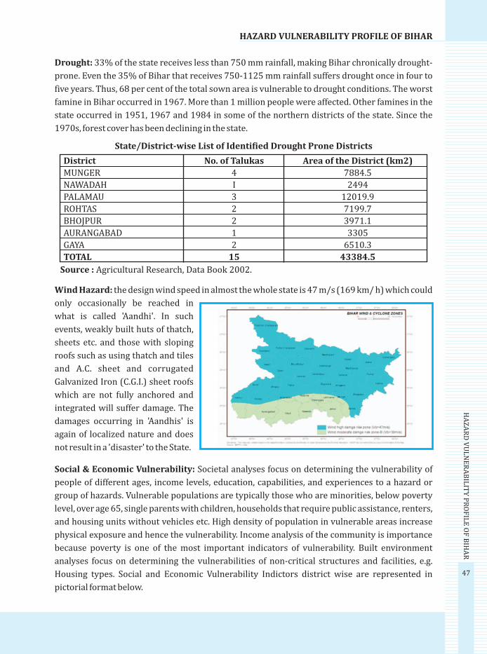
47
HAZARD VULNERABILITY PROFILE OF BIHAR
HA
ZA
RD
VU
LN
ER
AB
ILIT
Y P
RO
FIL
E O
F B
IHA
R
Drought: 33% of the state receives less than 750 mm rainfall, making Bihar chronically drought-
prone. Even the 35% of Bihar that receives 750-1125 mm rainfall suffers drought once in four to
five years. Thus, 68 per cent of the total sown area is vulnerable to drought conditions. The worst
famine in Bihar occurred in 1967. More than 1 million people were affected. Other famines in the
state occurred in 1951, 1967 and 1984 in some of the northern districts of the state. Since the
1970s, forest cover has been declining in the state.
Wind Hazard: the design wind speed in almost the whole state is 47 m/s (169 km/ h) which could
only occasionally be reached in
what is called 'Aandhi'. In such
events, weakly built huts of thatch,
sheets etc. and those with sloping
roofs such as using thatch and tiles
and A.C. sheet and corrugated
Galvanized Iron (C.G.I.) sheet roofs
which are not fully anchored and
integrated will suffer damage. The
damages occurring in 'Aandhis' is
again of localized nature and does
not result in a 'disaster' to the State.
Social & Economic Vulnerability: Societal analyses focus on determining the vulnerability of
people of different ages, income levels, education, capabilities, and experiences to a hazard or
group of hazards. Vulnerable populations are typically those who are minorities, below poverty
level, over age 65, single parents with children, households that require public assistance, renters,
and housing units without vehicles etc. High density of population in vulnerable areas increase
physical exposure and hence the vulnerability. Income analysis of the community is importance
because poverty is one of the most important indicators of vulnerability. Built environment
analyses focus on determining the vulnerabilities of non-critical structures and facilities, e.g.
Housing types. Social and Economic Vulnerability Indictors district wise are represented in
pictorial format below.
District No. of Talukas Area of the District (km2)
MUNGER 4 7884.5
NAWADAH I 2494
PALAMAU 3 12019.9
ROHTAS 2 7199.7
BHOJPUR 2 3971.1
AURANGABAD 1 3305
GAYA 2 6510.3
TOTAL 15 43384.5
Source : Agricultural Research, Data Book 2002.
State/District-wise List of Identified Drought Prone Districts

48
BIH
AR
FL
OO
D R
EP
OR
T -
20
07
Population Density Map: Most of the districts which have high population density are in the
flood prone areas like Sitamarhi, Muzaffarpur, Samastipur, Patna, Begusarai etc.
Housing Types: High % of Kaccha houses in the Earthquake and flood prone areas.
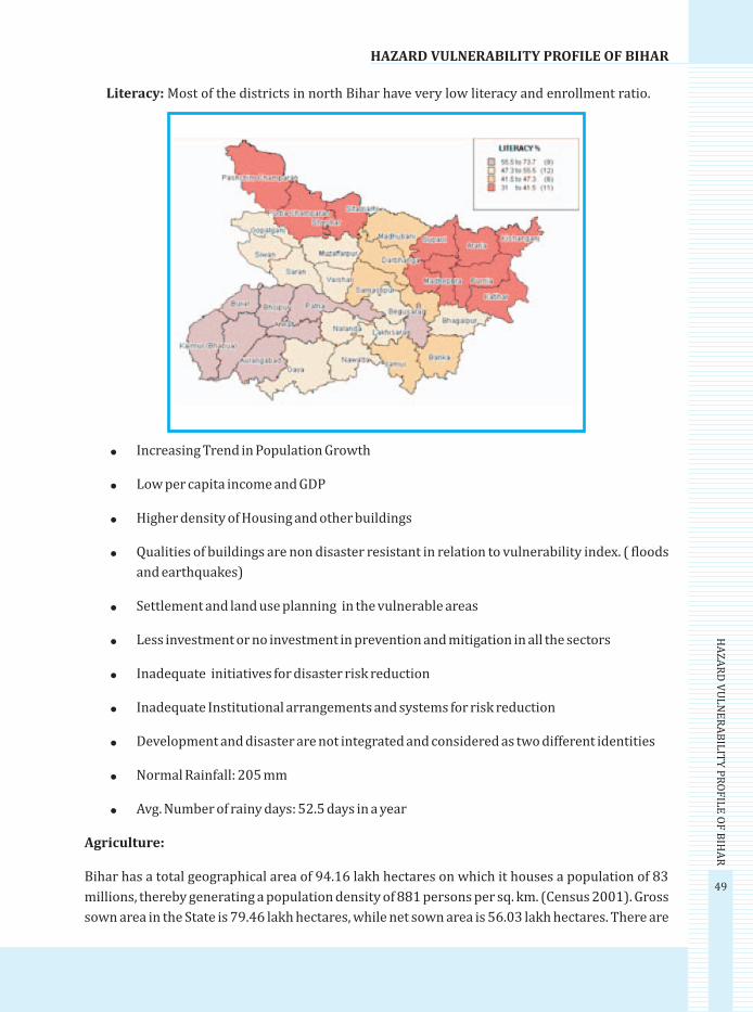
49
HAZARD VULNERABILITY PROFILE OF BIHAR
HA
ZA
RD
VU
LN
ER
AB
ILIT
Y P
RO
FIL
E O
F B
IHA
R
!
! Low per capita income and GDP
! Higher density of Housing and other buildings
! Qualities of buildings are non disaster resistant in relation to vulnerability index. ( floods
and earthquakes)
! Settlement and land use planning in the vulnerable areas
! Less investment or no investment in prevention and mitigation in all the sectors
! Inadequate initiatives for disaster risk reduction
! Inadequate Institutional arrangements and systems for risk reduction
! Development and disaster are not integrated and considered as two different identities
! Normal Rainfall: 205 mm
! Avg. Number of rainy days: 52.5 days in a year
Agriculture:
Bihar has a total geographical area of 94.16 lakh hectares on which it houses a population of 83
millions, thereby generating a population density of 881 persons per sq. km. (Census 2001). Gross
sown area in the State is 79.46 lakh hectares, while net sown area is 56.03 lakh hectares. There are
Increasing Trend in Population Growth
Literacy: Most of the districts in north Bihar have very low literacy and enrollment ratio.
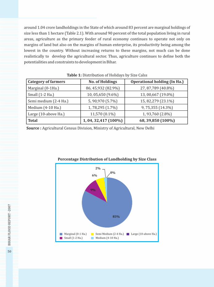
50
BIH
AR
FL
OO
D R
EP
OR
T -
20
07
around 1.04 crore landholdings in the State of which around 83 percent are marginal holdings of
size less than 1 hectare (Table 2.1). With around 90 percent of the total population living in rural
areas, agriculture as the primary feeder of rural economy continues to operate not only on
margins of land but also on the margins of human enterprise, its productivity being among the
lowest in the country. Without increasing returns to these margins, not much can be done
realistically to develop the agricultural sector. Thus, agriculture continues to define both the
potentialities and constraints to development in Bihar.
Source : Agricultural Census Division, Ministry of Agricultural, New Delhi
Category of farmers No. of Holdings Operational holding (In Ha.)
Marginal (0-1Ha.) 86, 45,932 (82.9%) 27, 87,789 (40.8%)
Small (1-2 Ha.) 10, 05,650 (9.6%) 13, 00,667 (19.0%)
Semi medium (2-4 Ha.) 5, 90,970 (5.7%) 15, 82,279 (23.1%)
Medium (4-10 Ha.) 1, 78,295 (1.7%) 9, 75,355 (14.3%)
Large (10-above Ha.) 11,570 (0.1%) 1, 93,760 (2.8%)
Total 1, 04, 32,417 (100%) 68, 39,850 (100%)
Table 1: Distribution of Holidays by Size Calss
Percentage Distribution of Landholding by Size Class
Marginal (0-1 Ha.)
Small (1-2 Ha.)
2%
0%6%
9%
83%
Semi Medium (2-4 Ha.)
Medium (4-10 Ha.)
Large (10-above Ha.)

51
ANNEXURE - IIM
AJO
R R
IVE
RS IN
BIH
AR
Major Rivers in Bihar
The Main Ganga Stem ( Bihar): The Ganga enters Bihar near Buxar in the middle region of its
course, nearly 155 km. Downstream from varanasi. The total length of the ganga in Bihar is nearly
445 km. Apart from 110 km. Along the UP-Bihar border. The catchment area of the main Ganga
stem in Bihar is about 16900 sq. km. The Ganga stem in Bihar comprises the main river course,
trunk and adjoining areas including 'diara' lands. The catchment areas of small rivers falling
directly into the main Ganga-stem have also been included as a part of the Ganga stem.
Ganga stem 'A' sub-basin includes the catchment areas of rivers like Kao, Dharamavati and other
small channels meeting the main stem of the river Ganga between its confluence with the river
Karmnasa near Chausa and that with the river Sone near Maner. The sub-basin is bounded by the
river Ganga in the north, the Sone in the east the Karmnasa in the west. Ganga stem 'B' sub-basin
includes the catchment area of the river Baya flowing between the Gandak river basin on the right
side and the Burhi Gandak basin on the left side with its northern boundary as Burhi Gandak basin
and the southern boundary as the main Ganga stem.Ganga stem 'C' sub-basin includes the
catchment area of small streams like Bhaena and Koa. This sub-basin is bounded by the Bilasi,
Chandan, Chir river basins in the south and the west, the Gumani in the east and the main Ganga
stem in the south. While traveling through Bihar, it has a number of tributaries on its left and right
banks which are important rivers in themselves. These are described in brief as below:
The Gandak: The Gandak known as the Kali in Nepal, originates near the Nepal-Tibet
border at an altitude of 7620 m situated northest of Dhaulagiri. While flowing in Nepal, it
receives a number of tributaries such as the Mayangadi, the Bari and the Trisuli. After
traveling nearly 100 km in Nepal, it enters the plains of the West Champaran district of
Bihar near Valmikinagar, Just above Valmikinagar, at Triveni on Indo-Nepal border it
receives two tributaries, the Panchnad and the Sohna. From Valmikinagar the Gandak
flows in southerly direction and forms UP-Bihar border to some distance and then it
flows through West Champaran, Saran, Muzaffarpur and Vaishali districts of Bihar before
joining the Ganga on its left bank opposite Patna city. The total length of the river is 630
km of which 370 km lies in Nepal and Tibet.
The Burhi Gandak: The Burhi Gandak takes off from Chautarwa 'Chatur' in the West
Champaran district. One of its major tributaries, the Masan rises from the springs of the
Someshwar hills at an elevation of 300 m. The river is known as Sikarahna in its upper
reach upto the confluence of the river Dhanauti. After flowing for a distance of about 56
km. the river takes a southerly turn where it is joined by Dubhara and Teur. From this
point, the river takes a south-easterly direction and flows through the Muzaffarpur
district for about 32 km. In this reach, the river spills over its banks and a number of spill
channels take off and join it later. Flowing through Darbhanga, Samastipur, Begusarai and
Munger districts, it joins the Ganga on the left bank near Khagaria town opposite to the
town of Munger. Its total length is 580 km.

MAJOR RIVERS IN BIHAR
52
BIH
AR
FL
OO
D R
EP
OR
T -
20
07
The Bagmati: The Bagmati rises in the Shivpuri range of hills in Nepal, 16 km. north-east
of Kathmandu at an elevation of 1500 m and flows in westward direction draining the
Kathmandu valley. The river cuts through the Mahabharata range of hills in Nepal and
enters India in Bihar in the village Shorwatia in the Sitamarhi district. In this reach, three
spill channels take off from the Bagmati and region together near village Joriahi at about
2.5 km south of Samastipur-Narkatiyaganj railway line. The river Lalbakeya, an
important right bank tributary of the Bagmati joins it near Dewapur just downstream of
Khoripakar. The river Bagmati once again tried to avulse into the Purani Dhar below
Khoripakar during floods in the year 1983. The Purani Dhar takes off near village Balwa
and is also called the Belwa Dhar. The take off point of this Belwa Dhar is very unstable
and is getting wider and wider to an extent that even in lean season nearly 40 percent of
the Bagmati river water passes through the Belwa Dhar which outfalls into the Burhi
Gandak near Minapur in the district of Muzaffarpur. The river Bagmati in its last reach is
joined by the Darbhanga-Bagmati river, one of its Major tributaries on the left bank, just
above Hayaghat. The Darbhanga-Bhagmati drains the Adhwara group of rivers. After the
confluence with the Darbhange-Bagmati, the river Bagmati is known as the Kareh. From
here it runs in south-east direction for 191 km and before outfalling into the Kosi near
Badlaghat, it receives the Hasanpur-Bagmati near Kudra on its right bank and the old
Kamla near Phuhia on its left bank. The total length of Bagmati is about 589 km of which
195 km lies in Nepal and the rest 394 km in Bihar.
The Kamla Balan: The Kamla Balan originates in the inner valleys of the Himalayas in
the Mahabharat range of hills in Nepal at an elevation of 1200 m. It is joined by a number
of streams on both the banks during its flow in the Mahabharata range in fact, two
important streams namely the Kalikhola and the Tawakhola flowing in opposite
directions, from west to east and east to west respectively, join together and flow in the
name of the river Kamla. The river Kamla after traveling a few kilometers in the west
emerges out through a gorge near Tetaria and debouches near the Terai area of Nepal at
chisapani about 48 km. north of Indo-Nepal border. In the Terai portion in Nepal, the river
is joined by the tributaries like the Jiwa, the Gurmi, the Lohjara, the Mainwati etc. on the
left bank. On the tight bank the Bachraja takes off from the Kamla, the mouth of which is
now silted up. It is an old abandoned course of river Kamla. Then onwards, the river flows
in southern direction and debouches into the plains near Indo-Nepal border and enter
Indian territory in the district of Madhubani in Bihar. It flows in southern direction till it
joins the river Kareh (Bagmati) near Badlaghat. The rivers Dhauri, Soni, Balan and
Sugarave join the river kamala on its left bank in the Indian territory. During the floods of
1954, the river Kamla abandoned its course near Bhakua village and avulsed into the
river Balan and since then it is flowing through the course of the river Balan and its hence
known as the Kamla – Balan. The total length of the river Kamla Balan is 238 km of which
208 km lies in Nepal and the remaining 120 km in India.
The Kosi: The river Kosi originated at an altitude of over 7000 m above MSL in the

53
MA
JOR
RIV
ER
S IN B
IHA
R
Himalayas. The upper catchment of the river system lies in Nepal and Tibet. The highest
peak of the world , the Mount Everest and Kanchanjangha lie in the Kosi catchement. It is
one of the anciednt rivers of India and has its mention in the old literatures as Kaushika..
It is known as Sapt Kosi in Nepal because its seven tributaries the Sun Kosi, the Bhota
Kosi,the Tamba Kosi, the Dudh Kosi, the Barun Kosi, the Arun Kosi and the Tamur Kosi
meet above Tribenin (about 10 km upstream of Chatra). Below the confluence of Tribeni,
the river Kosi flows in a narrow gorge for a length of about 10 km till it debouches into the
plains near Chatra, the river enters the Indian territory near Hanuman Nagar in Nepal.
The river Kosi has been notorious for its meandering behavior which would be apparent
from the fact that it had changed its course across a width of about 250 years.
Subsequently it flows in easterly direction and ultimately joins the Ganga near Kursela in
katihar district. The average bed slope of the river in different reaches from its origin to
outfall is in the range of 1.4/km to 0.11m/km.
The Mahananda: The river Mahanada is a major nothrern tributary of the river Ganga
passing through Nepal, India (Bihar and West Bengal) and Bangladesh. The Mahananda
originates from Mohalidram hill of the Himalayas at Chimali at an altitude of 2060 m and
about 6.4 km north-east of Kurseong town in Darjeeling district of west Bengal. After
flowing 20 km in the hills of Darjeeling the river enters the plains near Siliguri. River
Balason joins this river below Siliguri on its right bank. It then flows in a south-westerly
direction forming more or less the boundry between India and Bangladesh. The old
Balason river joins Mahananda on its right bank upstream of Sonapkur Hat. Another
tributary the Chenge joins the Mahananda on its right bank about 3.2 km upstream at
Taibpur railway bridge. Another stream Donk meet on its left bank near Belwa village.
The eastern kankai, a major tributary joins the Mahananda on the right bank near
Kuttighat at about 0.60 km downstream of its crossing with Kishanganj-Bahadurganj
road. The western kankai, another major tributary carrying discharge higher than the
Mahananada joins on its right bank about 3.2 km upstream of Dengraghat. The river
Mahananda bifurcates into two branches near Bagdob in Bihar. The western course
known as Phulhar (Jhaua) carries about 75% of the total discharge and is joined
downstream of Bagdob on the right side by Parman, major tributary. The eastern course
known as Barsoi branches carries the remaining 25% discharge. The total length of
Mahananda form its origin to outfall point in the river Padma near Godagrighat is 376 km.
The Karmnasa: The karmnasa originates near sarodag on the northern face of the
kaimur rang of hills in the Kaimur district of Bihar at an elevation of 560m. It flows in a
north-westerly direction through the plains of Mirzapur upto Lalitpur village in U.P. the
river flows through the district of Varanasi in U.P. and forms the common boundary
between U.P. and Bihar to a length of 76 km an finally joins the Ganga on its right bank
near Chausa in Bihar.
The Sone: The Sone originates in Maikala range of hills in MP at an elevationof 640m.
MAJOR RIVERS IN BIHAR
54
BIH
AR
FL
OO
D R
EP
OR
T -
20
07
after passing through the Vindhya range of hills in MP; it corsses the Kaimur hills and
flows in north east direction. It enters UP in Mirzapur district and flows in east direction.
It receives the Rihand and the Kanhar on its right bank and the Ghagra on its left bank
before entering Bihar through Palamu district where it receives the north Koel river on its
right bank. The river takes a north-east course and enters Rohtas district. It then forms
the boundry between Patna and Bhojpur districts for some distance and then flows
thourgh Aurangabad and Patna district, it joins the Ganga at about 16 km upstream of
Danapur in the Patna district. The river Sone has a total length of 784 km of which about
500 km lie in MP, 82 km in UP and the balance 202 km in Bihar.
The Punpun: The Punpun originates from Chotnagpur hills in Hariharganj block of
Palamu district in Bihar at an elevation of 442 km. The Punpun has four major right bank
tributaries namely the Morhar, the Dardha,the Madar and the Batane which have
significant contributions to its flood flow, whereas its left bank tributaries such as the
Khudwa, the Beige, the Siroka and the Panchane etc. are very small rivers and therefore
their contribution to the flood flow in the basin is insignificant. It flows for most of its
portion in a north, north-east direction and outfalls into the Ganga near Fatuha at about
25 km downstream of Patna. Its total length is about 235 km. As in the case of the main
river, the tributaries are also rained and majority or them originate from the same range
of hills in Palamu, Aurangabad and Gaya districts of Bihar.
The Kiul-Harohar: The main river Kiul of the Kiul-Harohar system originates form an
elevation of 605 m east of Khajuri in Chotanagpur plateau and flows in east direction
close to the southern base of Gidheswari hills. After that it flow in north-east direction
towards Lakhisari and joins the river Hrohar on its left bank. Then further down the
combined river joins the Ganga near Surajgarha in Mugher district. The Kiul-Harohar
river system consists of a number of small rivers such as the Lilajan, the Mohane, the
Falgu, the Panchane, the Goithwa, the Dhadhar, the Tilaya nand the Sakri etc. apart from
the Kiul and the Harohar which during the course of flow bifurcate and rejoin meeting
each other number of times making it difficult to ascertain their exact length.
The Badua: The river Badua rises in the southern most hills of Munger district, north-
east of Chakai at an elevation of nearly 333m. After flowing for a small distance in Munger
district it enter Bhagalpur district and flows through it for most part of its course. It flows
form south to north and falls in to the Ganga through Champa Nala situated west of
Bhagalpur town. But during the flood season, its spill mingles with the spills of the
Chandan river and other smaller rivers situated south of Bhagalpur. The floodwaters
thereafter, flow in the north-east direction and ultimately drains into the Ganga near
Nathnagar railway station east of Bhagalpur town.

55
ANNEXURE - IIIR
EC
OM
ME
ND
AT
ION
S OF
IMP
OR
TA
NT
.....
RECOMMENDATIONS OF IMPORTANT COMMITTEES / WORKING GROUPS/
TASK FORCES ON FLOOD MANAGEMENT APPOINTED BY THE GOVERNMENT
OF INDIA
1. Brief particulars of The Policy Statement – 1954 and Supplementary Statement
1956
Following the unprecedented floods of 1954, the Union Minister for Planning, Irrigation rdand Power, placed before Parliament on 3 September 1954, two statements namely
“floods in India – Problems and remedies” and “The Floods in the country”. The objective,
set unequivocally, in the policy statements, was to rid the country of the menace of floods
by containing and managing floods. In the supplementary statement placed before the thParliament on the 27 July, 1956, the optimistic note changed a little, stating “we shall,
however, be able to curb and confine the floods, more and more and do all that is possible
to save ourselves from the harm and the devastation that they bring”. Another statement
on the flood situation and flood control programme pointed out that absolute immunity
from flood damage was not physically possible even in the distant future.
2. The High Level Committee on Floods – 1957 and policy statement of 1958.
The High level Committee on Floods submitted its report in December 1957, and this was
considered by the Central Flood Control Board in its seventh meeting held in May 1958.
Some of the important recommendations and this includes were,
(1) Absolute or permanent immunity from flood damage is not physically attainable by
known methods of flood control. Flood plain zoning, flood forecasting and warning,
and like measures should, therefore, be given due importance, particularly as these
do not require large capital investment.
(2) Flood control schemes should fit in with other water related plans to the extent
feasible.
(3) Future multi-purpose projects should consider flood control aspects simulta-
neously.
(4) Effects of embankments on river regimes need to be considered before approving
such proposals.
(5) In general, embankments are satisfactory means of flood protection when properly
designed, executed and maintained, but a suitable combination of this method with
other methods such as storage dams, detention basins, etc. is usually more efficient
and should be adopted as resources permit.

56
BIH
AR
FL
OO
D R
EP
OR
T -
20
07
RECOMMENDATIONS OF IMPORTANT .....
(6) Priorities for soil conservation work relating to flood control should be as under:-
(a) Catchment areas of multi-purpose dams.
(b) Himalayas with their foothills.
(c) Indo- Genetics Plain and
(d) Deccan plateau.
(7) Works relating to watershed management prioritized. Work commenced in a
catchment should not be left incomplete to take up work in other catchments.
(8) The following order of priority in general is recommended:-
(a) Emergent Schemes
(b) Continuing Schemes
(c) Schemes for the protection of important urban and industrial communities.
(d) Schemes which would help in augmenting flood protection in the country.
(e) Schemes which combine other beneficial utilization of waters.
Another policy statement tabled in Parliament in 1958 also emphasizes that while
substantial diminution of flood related distress is possible, immunity against flood is
impracticable.
3. The Ministers' Committee on Flood Control – 1954
A Minister's Committee on Flood Control was constituted in February 1964, to review the
National Flood Control Policy outlined in 1954. The Committee mainly recommended
more attention to non-physical measures like flood warning and forecasting, flood plain
zoning, flood insurance, studying possibility of multipurpose storage dams for flood
prevention and sediment detention in regard to major flood producing catchments,
administrative measures for restricting occupancy of flood zones and emphasis on flood
zones and frequency studies.
4. The Working Groups on Flood Control for the Five – Yea Plans
The Working Groups on Flood management, comprising of experts and administrators,
review the progress and performance of flood management measures undertaken and
suggest appropriate strategies to formulate proposals including mobilization of
resources for each five year plan and recommend measures, required for effective flood
management program in the country.
5. The Rashtriya Barh Ayog- 1980
The National Flood Commission (RBA) submitted its comprehensive report in March,
1980. This contained a total of 207 recommendations covering the entire gamut of flood
problem in the country. Some of the important recommendations were.

57
RE
CO
MM
EN
DA
TIO
NS O
F IM
PO
RT
AN
T .....
- Data Collection for providing information on their long-term performance and their impact on various socio-economic factors.
- Legislation and enforcement by States to prevent unauthorized riverbed cultivation and encroachments into drains etc.
- Separate reporting of floods damage for (i) Unprotected areas (ii) Protected areas and (iii) Areas situated between the embankments.
- Legislation for management of flood plains
- A comprehensive dynamic and flexible approach to the problem of floods as a part of a comprehensive approach for the utilization of land and water resources.
- Priority for measures to modify the susceptibility of life and property to flood damage.
- Priorities for the completion of continuing schemes.
- Provision of adequate funds for maintenance.
- States to enact legislation amending section 17 (II) of land acquisition act, to make the existing provisions for emergent situations, as applicable for flood control works.
- Intensifying studies on sedimentation of reservoirs.
- Forming a National Council for mitigating the effect of the disaster.
A review of implementation status of these recommendations made by CWC during 1987 and subsequently during 2003 indicated that there is much to be achieved.
6. The Pritam Singh Committee Report – 1980
To examine the problem of erosion in West Bengal on both banks of the river Ganga upstream and downstream of Farakka Barrage, Government of West Bengal set up a committee in August 1978 under the Chairmanship of Shri Pritam Singh, Member (Floods), CWC. The Committee comprised of chairman, GFCC, Director CWPRS, General Management, Farakka Barrage Project, Chief Engineer, Government of Bihar and West Bengal.
The Committee identified the priority reached downstream of Farakka Barrage for taking anti-erosion measures.
7. The National Water Policy – 1987
Important recommendations made in the National Water Policy of 1987 on flood control and management were:
- Basin wise master plan for flood management in each flood prone basin.
- Sound watershed management and catchment area treatment.
- Providing adequate flood – cushion in water storage projects wherever feasible.
- Emphasis to be made on measures like flood forecasting and flood plain zoning to minimize flood damage.
58
BIH
AR
FL
OO
D R
EP
OR
T -
20
07
RECOMMENDATIONS OF IMPORTANT .....
8. The report of the Committee on Flood Management in the North – Eastern States –
1988 (Naresh Chandra Committee)
During the year 1987, when the failure of the monsoons resulted in an unprecedented
drought in most parts of the country, Assam and the neighboring States had the misfor-
tune of experiencing large- scale flooding of the Brahmaputra valley. A Committee was set
up under the Chairmanship of the Secretary, Water Resources to look into this problem in
some detail, review the efficacy of the current measures being taken and recommend
further measures.
The Committee suggested that the recommendations of the Rashtriya Barh Ayog should
be implemented by the State Governments, Anti-erosion works are costly and can be
justified only when protection is provided to vital installations. The main cause of erosion
in tributaries is impinging of high velocity. To overcome this problem, bank revetments,
preferably made with boulders, should be used. For drainage improvement the adequacy
of existing sluices and drainage channels should be checked in a timely manner.
9. The Report of the Committee on Flood Management in the States of Bihar, West
Bengal, Uttar Pradesh and Orissa – 1988
After the severe floods of 1987in Bihar, West Bengal, Uttar Pradesh etc. the Government
of India set up a Committee under the Chairmanship of Secretary (Water Resources) to
review the efficacy of the current measures and recommend measures for urgent
implementation. Some specific recommendations of the Committee include:-
a. Properly designated, satisfactorily executed and adequately maintained embank-
ments should continue as cost effective and quick measure.
b. Early completion of partly completed projects.
c. Construction of raised platforms on Government or acquired land and handing over
to local bodies / panchayats.
d. Ensuring adequate waterways to ease out drainage congestion.
e. Operation of existing reservoirs keeping flood moderation in mind even if no flood
cushion is provided.
f. Provision of flood benefit/reserve storage in new /future reservoir projects to the
extent possible.
g. Implementation of flood plain zoning.
h. Settling cost sharing among beneficiaries of anti-erosion works executed.
i. Setting up of Tal Development Authority and arranging special funding for develop-
mental schemes suitable to Tal/Chaur areas.
j. Allocation of more funds for early completion of unfinished schemes in Sundarbans
of West Bengal.
k. Evaluation of completed project by states with the assistance of GFCC/CWC.

59
RE
CO
MM
EN
DA
TIO
NS O
F IM
PO
RT
AN
T .....
10. The National Commission for Integrated Water Resources Development Plan
The National Commission for integrated water resources development plan in its report (Sept. 1999) made interalia, the following recommendations regarding flood manage-ment.
a. Since there are no solution for complete protection against floods, the country has to shift its strategy towards efficient management of flood plains, flood proofing, flood forecasting, disaster preparedness and response planning, flood fighting and flood insurance.
b. Embankments provide reasonable protection against floods. However the perfor-mance of embankments have to be evaluated and suitable changes be made in design, construction and maintenance for better results.
c. The network of flood forecasting and warning is to be extended to remaining flood prone areas.
11. The Recommendations of the Regional Task Forces
During the monsoon of 1996, a large number of States including Rajasthan and Haryana, which were generally not flood prone, experienced floods of severe intensity causing extensive damage to life and property. Certain coastal areas experienced chronic problems of coastal erosion. It was, therefore been considered essential to examine the problem of floods and flood management in the country afresh. Consequent upon this, Government of India had constituted five regional Task Forces namely.
(i) Eastern Region Task Force
(ii) Northeastern Region Task Force
(iii) Northern Region Task Force
(iv) Northwestern Region Task Force
(v) Southern Region Task Force
The main thrust areas identified for actions by these task forces were
a. Implementation of main recommendation of RBA.
b. Prepare a catalogue of embankments existing in various river systems.
c. 10% of annual out lay of flood control sector to be earmarked for maintenance of flood control structures.
d. Studies on some major reservoirs and review of Operation / rule curves.
Other important measures recommended in general are the tackling of encroachment of people into flood plains of the river downstream of the dam and inside embankments, taking up flood plain zoning measure especially the preparation of flood risk maps, scientifically analyzing the happenings of severe rainfall occurrences, very high flood stages and prolonged heavy drainage congestion in specific years, within a reasonable time of occurrence of such events by State Governments etc.

60
BIH
AR
FL
OO
D R
EP
OR
T -
20
07
RECOMMENDATIONS OF IMPORTANT .....
12. The Experts' Committee for Bank Erosion Problem of River Ganga- Padma in the
Districts of Maida and Murshidabad in West Bengal – 1996 (G. R. Keskar
Committee)
Considering the gravity of the situation of bank erosion problem of river Ganga in the
districts of Madia and Murshidabad in West Bengal, the Planning Commission,
Government of India, constituted an Experts Committee under the Chairmanship of Shri
G. R. Keskar, Member (RM), CWC in September, 1996.
Various measures recommended by the Committee are as under:
(i) Short-Term Measures recommended for immediate execution
th thThis includes construction of two long spurs at the 29 and 28 km upstream of Farakka
Barrage near Manichchak, closing of the gap in left marginal embankment,
repair/restoration of existing protection works in the district of Maldaand maintenance
of Bhutni Diara Embankment.
Right Bank Downstream of Farakka Barrage in the district of Murshidabad.
Repair/ Restoration of existing works, construction of spurs near Bindugram down-
stream of Farakka Barrage, Affiux bundh with revetment along-with nominal lauching
apron in Fazilpur reach etc.
(ii) Long – Term Measures
Monitoring of performance of two long spurs upstream of Farakka, restricting flow
through Barrage normal to its axis as possible by gate regulation, Extensive river survey
before and after flood every year for morphological study and creation of data bank for
regular analysis etc.
13. The Expert Group for Flood Management in Uttar Pradesh and Bihar – 1999 (G. N.
Murthy Committee)
An Expert Group was set up under the Chairmanship of Shri G. N. Murthy, the then
Chairman, GFCC, Patna to examine and suggest action plan of identified specific flood
management scheme with interse priority for implementation. The Group emphasized
the need for building up realistic data bank on hydrology, topography, geology, morphol-
ogy, hydraulics, damage etc. As long term solution construction of storage reservoirs and
watershed management and as long term measure the priority schemes consisted of
schemes on closure of gaps in the embankment/ extension of existing embankments,
embankment scheme, anti-erosion works, drainage, schemes in Bihar and Uttar Pradesh.
Left Bank pstream of Farakka Barrage in the District of Maida

61
RE
CO
MM
EN
DA
TIO
NS O
F IM
PO
RT
AN
T .....
th14. The Working Group on Flood Control Programme for the 10 five Year Plan –2001
(R Rangachari Working Group)
A Working Group on Flood Control Programme was set up by Planning Commission,
Government of India in November, 2000 under the Chairmanship of Shri R. Rangachari,
whose terms of reference included the review of the performance of the sector during the th th9 Plan period and making suggestions on the appropriate strategy for the 10 Plan
period etc.
The report submitted in August 2001 had made a review of the flood management works
adopted so far and gave suggestions on the future strategy for flood management. It dealt
upon many policy issues and examined the international dimension of the flood manage-
ment. It had made a review of the implementation of the RBA recommendations, too.
15. Report of the Committee on Silting of Rivers in India – 2002 (Dr. B. K. Mittal
Committee)
To study and report on the problem of silting in Indian rivers and related aspects includ-
ing feasibility of desilting, Ministry of Water Resources constitute a committee in October
2001 under the Chairmanship of Dr. B. K. Mittal, Former Chairman, CWC. Its main
recommendations were:-
Measures for minimizing Siltation
a. Catchments afforestation, right practices of land use, catchment area treatment, and
others.
b. In the river itself construction of suitable hydraulic Structures that may trap silt.
c. Embankments along the aggrading river should be constructed, only after proper
studies are made on its behaviour especially due to sedimentation load and resultant
morphological changes.
Efficacy of desilting
d. Desilting in general technically not feasible due to non-sustainability, non – availabil-
ity of vast land for disposal of dredged material.
e. Dredging has insignificant effect on flood magnitude.
f. Selective dredging may be undertaken after a thorough study of each case for
desilting of tidal rivers or confluence points and to maintain minimum depth of
water for navigation.
16. The Expert Committee to Review the Implementation of the Recommendations of
Rashtriya Barh Ayog- 2003 (R- Rangachari Committee)
An Experts Committee under the Chairmanship of Shri R. Rangachari was set up by
Ministry of Water Resources, Government of India in October 2001 to review the imple-
mentation of recommendation of Rashtriya Barh Ayog.

62
BIH
AR
FL
OO
D R
EP
OR
T -
20
07
RECOMMENDATIONS OF IMPORTANT .....
The Committee summed up its view as follows:-
a. Flood damage assessment from year to year, is not done realistically or on scientific basis as per surmised but not expressed. This needs corrective steps.
b. Lack of representative, scientific and credible post- project performance evaluations of past flood management works is a serious handicap.
c. Unabated and unplanned intrusion into the flood plains and riverbeds, sometimes with the approval of acquiescence of Government has now reached alarming dimensions. If this is not managed, flood losses will continue to mount.
d. RBA has made a number of recommendations on the future approach and the planning and implementation thereof. Most of these have not been implemented or at the best partially implemented. They will have to be kept in view as part of future approach.
e. The international dimensions of flood management as an integral part of Water resource development and management must be pro actively addressed.
f. A number of other issues of importance like adequate funds, legislation, research and people's involvement at all important stages, etc. are very important to effec-tively manage floods. However, the inter-state issues in multi state river basins is a very important matter waiting to be effectively addressed.
17. The Committee for identification of critical Anti- Erosion Schemes of Ganga Basin thStates for Inclusion in CSS to be implemented during 10 Plan – 2003 (CB Vashistha
Committee)
Keeping in view the seriousness of river erosion and its associated problems, Ministry of
Water Resources, Government of India constituted a Committee to identify the Schemes
for inclusion in the Centrally Sponsored Scheme “Critical anti-erosion works in Ganga thBasin States for 10 Plan” under the leadership of Shri C. B. Vashistha, Chairman, GFCC.
The Committee visited the critical anti-erosion sites of river Ganga in Uttar Pradesh,
Bihar and West Bengal for assessment of the problem and gave its recommendations
which have largely been implemented.
18. Report of the Technical Group on Flood and Erosion Problems of North Bengal –
July 2004 (M. K. Sharma)
The river like Teesta, Jaldhaka, Torsa, Raidak and Mahananda draining the North Bengal
along – with their several tributaries cause flood erosion problem in region. To study the
flood and erosion problem of the region and suggest suitable measures Ministry of Water
Resources constituted a technical group comprising of representatives from concerned
Central and State Organisations under the Chairmanship of Shri M. K. Sharma, Member
(RM), CWC.
a. Design flood estimation may be done in accordance with the sub zonal report of CWC.
b. River training/activation of channel may be attempted on selected reaches where feasible.
63
RE
CO
MM
EN
DA
TIO
NS O
F IM
PO
RT
AN
T .....
c. Maintenance of embankments during the pre monsoon and the monsoon period may be undertaken in accordance with the these guidelines given in the embankment manual.
d. Considering the magnitude and severity of flood and erosion problems in North Bengal region it is suggested that comprehensive plan for flood management for north Bengal may be prepared.
e. Material such as bamboo, branches of trees, river shingle and boulders which are locally available at comparatively lower cost can be utilized for inducing siltation diverting the river flows and preventing the bank erosion.
f. Implementation of prioritized schemes (listed in the reports) to be taken up during th10 Plan.
19. National Water Policy 2002
! Basin-wise mater plan for flood control and management.
! Provision of adequate flood cushion in reservoir projects.
! Flood control to be given overriding consideration in reservoir regulation policy.
! More emphasis on non-structural measures.
! Strict regulation of settlements and economic activities in flood plains.
! Flood forecasting activities to be modernized and expanded.
20. The Task Force on Flood Management and Flood Control
A Task Force was set up by the Ministry of Water Resources (MoWR) (vide order No.
24/32004-Er/2812 – 48 dated 11 August, 2004) to look into the problem of recurring
floods in Assam and neighboring states as well as Bihar, West Bengal and eastern Uttar
Pradesh under the chairmanship of Chairman, Central Water Commission (CWC) and
Secretary ex-officio to the government of India. The Terms of Reference of the Task Force
were.
(i) To examine the causes of the problem of recurring floods and erosion in Assam
and other neighbouring states as well as Bihar, West Bengal and eastern Uttar
Pradesh.
(ii) To review the measures undertaken so far to combat floods and erosion.
(iii) To suggest short-term and long – term measures for management of floods and
erosion control.
(iv) To examine related international dimensions and suggest future course of
action.
(v) To suggest institutional arrangements for tackling the problem.
(vi) To suggest sources of funding for the future action plan.
(vii) To examine any other related matter /issues

64
BIH
AR
FL
OO
D R
EP
OR
T -
20
07
RECOMMENDATIONS OF IMPORTANT .....
stThe Task Force submitted its report to MoWR on 31 December, 2004. The broad recom-
mendations of the Task Force were
(i) The role of the Central Government in the Flood control sector be expanded. It
has recommended that the flood control schemes should be funded through the
Centrally Sponsored Scheme in the ratio of 90% Central and 10% State from the
present 75.25. The Task Force has recommended that the corpus for Centrally
Sponsored Scheme also needs to be increased substantially to accommodate all
critical flood management and critical anti-erosion works.
(ii) Schemes worth Rs. 316.14 crore be taken before the coming flood season as an
immediate measure. The Schemes worth Rs. 2030.15 crore have been recom-
mended under Short Term- I category to be executed during the remaining two
years of the X Five Year Plan i.e. during the 2005-06 and 2006-07 and Rs. 2635.81
crore under Short Term –II category to be completed in X Plan.
(iii) The total investment for plan /flood Management may be increased from the
existing half percent of the total Plan outlay to at least 1%
(iv) Funds in the State sector be earmarked as Additional Central Assistance for
maintenance of embankments.
(v) Eligibility criteria of schemes for Central funding be reduced to Rs.1 crore from
the existing limit of Rs. 3 crore per scheme.
(vi) A revolving fund of Rs. 50 Crore, which may be available annually to the Ministry
of Water Resources to take up emergent flood management schemes be created.
The normal requirement of 'in principle; approval of the Planning Commission is
recommended to be waived in this particular case. The Schemes under this fund
could be implemented by the States/Boards after inspection by CWC/
Brahmaputra Board. The Task Force has further recommended that to mobilize
resources for this revolving fund, a flood cess of say 1% to 2% could be levied on
new infrastructure like roads, buildings, power plants etc. in the flood prone
states.
(vii) The central Government may consider funding the flood control component of
the reservoir projects.
(viii) Under the institutional arrangements, an Authority in the north East region with
all the statutory powers be set up. In the meantime the Brahmaputra Board be
Strengthened and restructured. The Sikkim and North Bengal.
(ix) The Ganga Flood Control Commission be strengthened by addition of the post of
Member (Works) and appropriate field formation for investigation and execu-
tion of critical flood management works be created.
(x) The jurisdiction of Farakka Barrage Organisation, be extended.

65
RE
CO
MM
EN
DA
TIO
NS O
F IM
PO
RT
AN
T .....
(xi) In order to have policy formulation and coordination among various agencies,
Flood Management Organisation of the Central Water Commission be strength-
ened by restoring the post of Member (Floods) abolished earlier and redeploy-
ment of posts of Chief Engineer, two Directors and other lower level functionar-
ies.
(xii) The Brahmaputra Board and the proposed Sikkim and North Bengal river
Management Board be entrusted the techno-economical examination of the
schemes upto Rs 15 Crore fro submission to the Planning Commission for
investment clearance.
(xiii) The reservoir projects in the Northeast as well as in Nepal and Bhutan be
expedited under the category of long term measures for flood management.
66
BIH
AR
FL
OO
D R
EP
OR
T -
20
07
1) The Bihar Flood Story; Dinesh Kumar Mishra, Economic and Political Weekly, August 30, 1997 pp: 2206-2217
2) Marta Paani: floods in Bihar, Editor: Hemant and Raj Valabh, Aggarwal Press, Jharkhand, 2005
3) “Bihar Ki Nadiyaan”, part-1, Hawaldar Tripathi, Bihar hindi Granth Academy, Patna, January 2003
4) Dakshin Bihar Ki Nadiyaan: Dhaar aur Kachaar; Hawaldar Tripathi, Bihar Hindi Granth Academy, Patna, October 1998
5) Report on Flood affected/ heavy rainfall affected area/ population in Patna District; Dr. B. Rajendrer, IAS, District Magistrate, Patna, 2007
6) Floods and its implications in the state of Bihar; Vinod K. Sharma and Tanu Priya, National Center for Disaster Management, IIPA, New Delhi, December 2002
7) Flood a permanent hazard for Bihar: A case study of bihar flood 2004; Dr. Rajan Sinha, Post graduate diploma in disaster management, Indira Gandhi National Open University, 2006
8) Government of India: Central Water Commission; Training Programme on Flood Management and forecasting, National Water Academy, Sinhagad Road, Khadakwasla, Pune, October 28- 01 November, 2003
9) Report on Bihar Floods-2007; For the central Team of the government of India, Government of Bihar, Department of Disaster Management
10) Sharing of views on Bihar Floods; Bihar Industries Association, Patna, 31 August 2007 (www.gpscdmrd.org)
11) Government of Bihar official website: http://gov.bih.nic.in
12) Government of Bihar: Disaster Management Division website: http://disastermgmt.bih. nic.in
13) News Article: Bihar- breaches of promises (source: www.indiadisasters.org)
REFERENCES

Desi
gn &
Pri
nted
by
: DEL
UXE
PRI
NTE
RY (
m)
9811
2951
20/1
10
NATIONAL INSTITUTE OF DISASTER MANAGEMENT (Ministry of Home Affairs, Government of India)
IIPA Campus, 5B - IP Estate, Mahatma Gandhi Marg, New Delhi-110002 (India) Tel. 011-23702432, 23705583, 23766146, Fax: 011-23702442, 23702446
Website: www.nidm.gov.in
Towards a disaster free India