
BIG GAME MIGRATIONS & LAND-USE PLANS
9
BIG GAME MIGRATIONS & LAND-USE PLANS Ensuring the Best-Available Science Guides Public Land Management Across the West
Transcript of BIG GAME MIGRATIONS & LAND-USE PLANS
BIG GAME MIGRATIONS & LAND-USE PLANSEnsuring the Best-Available Science Guides Public Land Management Across the West

Big Game Migrations & Land-Use Plans 0201Introduction Case Study Conclusion
These agencies—often working with the U.S. Geological Survey, federal agencies, tribes, and outside research consultants—have invested millions of state and federal dollars in mapping these movements. Funding for this work also comes from hunting license fees, which states use to support research and management.
As a result of these studies, researchers also began to clearly understand and precisely document what others have observed anecdotally for a long time: Wildlife populations throughout much of the West undertake seasonal migrations, and, in many places, big game herds show a high level of fidelity to corridors that have been used by countless generations of animals.
This knowledge highlights the responsibility of federal land agencies to work collaboratively and cooperatively with states, tribes, and private landowners to ensure the continued persistence of migrations. This science also should be informing agencies’ management decisions, both as a means of reducing conflicts with wildlife and to guide proactive efforts to improve and enhance habitats for migratory species.
Migrating herds across the West face an array of threats driven by the rapid transformation of the region. As our population grows—resulting in more residential and commercial development, increased road densities, and energy extraction—wildlife habitat is lost and fragmented. Studies show that human development within a migration corridor can disrupt the normal day-to-day patterns of herds on the move.
Mule deer are known to move faster through developed areas, reduce time spent in stopovers, and avoid traditional stopovers altogether where development is most intensive. Researchers in Wyoming also recently discovered that mule deer continue to avoid areas within a half-mile of well pads used in oil and natural gas drilling for more than 15 years after the development of these sites, meaning that herds don’t habituate to these disturbances.
Contrary to what some may think, big game animals will not simply find somewhere else to go. They exhibit strong fidelity to their traditional routes, meaning they aren’t likely to abandon their known paths and preferred habitats, even when they become unusable.
These behavioral changes could mean that a migrating animal eats less food and burns more energy negotiating human structures like oil pads and roads. Researchers in Wyoming also recently found that for every 1 percent loss of available forage from the physical footprint of infrastructure on mule deer winter ranges, there was an additional 4.6 percent loss of forage from the herd’s avoidance of such development.
It’s not hard to see how this translates into poorer animal condition, higher winter mortality, lower reproduction, and overall fewer deer for hunters to pursue. In fact, studies in Wyoming demonstrate that one particular mule deer herd declined by 36 percent during a period of development in its habitat.
Thankfully, a wide variety of stakeholders recognize the importance of the issue and embrace commonsense solutions to conserve big game migrations. State transportation departments are installing highway overpasses and underpasses to facilitate safe road crossings, while wildlife agencies are developing comprehensive plans to identify and conserve the functionality of important migration corridors. Land trusts are investing tens of millions of dollars in voluntary conservation easements on private ranches, while volunteers are working with federal and state agencies as well as private landowners to remove or replace hundreds of miles of fencing, allowing wildlife to move with less risk of getting entangled.
In February 2018, the Department of the Interior released Secretarial Order 3362 to prioritize documenting and conserving migration routes. Among other things, the order helps direct federal funding for habitat projects and treatments. At the same time, action plans developed by the states in accordance with the order focus on documenting and safeguarding migrations.
Scientists and wildlife managers clearly understand the need for migration research and conservation of corridors. With sufficient information, wildlife managers can make informed decisions for big game that reduce or even eliminate conflict between economic development and wildlife habitat. These two purposes and their associated uses can coexist, but it won’t happen on its own.
Land-use plans guide on-the-ground actions of land management agencies, which is why it is critically important that they incorporate the most up-to-date understanding of how agency decisions will affect wildlife populations. These plans set goals and objectives and determine appropriate uses for our public lands. They outline strategies to manage and conserve the public’s resources, and they set up a process for measuring the success of these strategies over time. Decisions, such as where to build and maintain roads and trails, how to balance wildlife habitat with development, and where to prioritize active habitat management, take their shape from these critical documents.
Yet, if the explicit recognition of migration corridors and subsequent management direction for these habitats is missing from federal land-use plans, agency personnel may be unable to use the best-available science to make informed decisions. The resulting consequences could be incompatible development in sensitive habitats or missed opportunities for habitat improvement in and around migratory routes.
With updated plans that pay mind to migrations, federal land managers can ensure their decisions always consider the conservation of these corridors. Managers could then continue working together with states, tribes, nonprofits, companies, and private landowners to secure the best future for the big game herds that have come to define the West.
Each spring and fall, waves of migrating wildlife sweep across the West. Mule deer travel as far as 150 miles—through deserts, over mountain passes, and across raging rivers. Elk push through snowstorms and heat. Pronghorn glide over prairies and foothills. Migration is essential to many of the West’s big game herds. It allows rugged, sometimes harsh, and diverse landscapes to support thousands or even tens of thousands of animals. In the spring, these animals gradually move from their low-elevation wintering habitats toward summering areas to follow the “green wave”—the swaths of lush grass and forbs emerging as the snow recedes. In the fall, many of these animals follow the same general path back to where they started, as snow covers their food and drives them lower and lower into wintering habitat.
Mule deer, elk, pronghorn antelope, bighorn sheep, and other large mammals move across a patchwork of federal, state, tribal, and private lands. As they travel these migratory routes, big game face many risks and obstacles, and the ability of wildlife to move and take advantage of the nutritious spring green-up—or stop to rest and refuel during the fall—is only becoming more difficult across many Western landscapes. Energy development, housing, fences, and roadways all impinge on the ability of animals to utilize the travel routes they have depended upon for generations and sometimes millennia, while invasive species, wildfires, and climate change are altering habitats within corridors.
With almost 600 million acres of federally managed public land in the West, many migrating big game animals cross through landscapes overseen by the U.S. Forest Service, Bureau of Land Management, and the U.S. Fish and Wildlife Service. But these public agencies are often unable to proactively conserve and improve these routes, because the decades-old land management plans that guide their decision-making rarely include any mention of this emergent conservation priority. Most plans were created before science had demonstrated how predictable and consistent many herds are in their movements and before GPS collars could pinpoint the precise locations of corridors.
In recent years, our understanding of the threats to the continued functionality of these habitats has advanced to the point that it can suggest actionable, pragmatic solutions to ensure their conservation. In the meantime, outdated land-use plans are being used every day for on-the-ground management decisions about what can and cannot happen on our public lands, including where to prioritize habitat improvement projects, where to site energy development, and how to manage recreation.
Fortunately, many agency land-use plans are due for an update, and a recently developed body of scientific knowledge is readily available to inform public land management plans and help federal land managers make the best decisions to conserve and sustain the West’s storied big game migrations.
Our understanding of how big game animals use the landscape to move between seasonal habitats has changed dramatically over time. While indigenous cultures have used their knowledge of wildlife migration for thousands of years to secure food, clothing, and shelter, scientists first began documenting migrations in the early 1900s, with observations of elk moving in and around Yellowstone National Park. By the 1950s, researchers were using planes to survey animal movements and, in the early 1970s, renowned biologists Frank and John Craighead began placing radio collars on elk.
This technology improved quickly, and wildlife managers used radio telemetry to document the movement of a variety of species throughout the West. The data from radio telemetry collaring gave a general understanding of migration paths, but it still only provided a few dozen data points over a year or two of study.
Then came GPS technology, which at first was bulky, expensive, and limited by battery life. It, too, has advanced rapidly, and now GPS collars can be programmed and monitored remotely, providing up to a dozen data points per day. Scientists are capable of building a detailed travel log for the spring or fall journey of each pronghorn, bighorn sheep, or mule deer fit with these sophisticated collars.
Today, state wildlife agencies across the West place GPS collars on many big game species. The resulting data allows managers to determine precisely where big game herds summer and winter, how they move from one place to another, and where they stop to rest and feed along the way.
D. MANGUS

Big Game Migrations & Land-Use Plans 04
Case Study:
With a glance at the map, Oregon’s Blue Mountains appear as one simple range—stretching across much of the state from its center to its northeast corner—but the reality on the ground is much more complex. The Blues comprise a seemingly endless series of ridges and valleys dotted with forests, brush fields, and meadows. Among them live one of the largest elk herds in North America, more than 75,000 mule deer, and bighorn sheep, moose, wolves, wolverines, and countless avian species. Rivers such as the John Day, Grande Ronde, and Imnaha carve out deep canyons that slice through the Blues and provide spawning habitat for chinook salmon and steelhead.
More than a century of logging and mining in the Blue Mountains has resulted in thousands of dirt and gravel roads slicing across the range in many areas, providing access to nearly every corner of the forest. Disagreement over which roads should be open for motorized recreational use—and ultimately the appropriate density and location of motorized traffic within these three forests—presents one of the biggest obstacles to bringing stakeholders together for a forest plan revision.
Spanning 5.5 million acres across the Blues, the Wallowa-Whitman, Umatilla, and Malheur national forests are still managed under obsolete plans developed in the early 1990s. In fact, the Wallowa-Whitman and Malheur are two of the only remaining forests in the nation without a travel management plan, which is needed to set clear direction for motorized use of roads and trails.
The Blues are also home to the one Forest Service Research Station specially focused on the science of deer and elk management. Decades of research from this station highlights that big game avoid roads and need areas of security to remain on public lands. Researchers have helped shape commonsense solutions to manage for motorized use and developed elk security standards that should be incorporated into future plans.
The Forest Service attempted a plan revision in 2014 and 2018, but neither effort was successful. During these processes, much of the local community disagreement centered on the possibility of road closures.
But, in the more than 30 years since the forest plans were last revised, elk numbers have grown to more than 50,000 and their movements are shifting. More elk are traveling earlier in the year to winter range on private lowlands and staying there later. That means landowners deal with more hungry mouths for a longer period. It also means fewer elk are available for hunters on publicly accessible land.
More concerning are mule deer numbers. Populations are down across the state, and the Blue Mountains are no exception. Twenty-one hunt districts cover the Blues, and in 2015, biologists estimated a population of 96,000 mule deer in an area with an objective of 151,800 animals. Just four years later, in 2019, those same biologists estimated there were only 75,000 mule deer.
OREGON
Preliminary analyses from more than 1,000 GPS-collared mule deer demonstrate the importance of summer range provided by the Wallowa-Whitman, Umatilla, and Malheur national forests for big game herds.
JON NELSON
Solutions to the challenges facing migratory mule deer in this region could lie in the millions of data points that have been collected over the past decade by the Oregon Department of Fish and Wildlife.
Preliminary analyses from more than 1,000 GPS-collared mule deer demonstrate the importance of summer range provided by the Wallowa-Whitman, Umatilla, and Malheur national forests for big game herds. New migration corridors are also being discovered and researchers have observed some deer migrate as far as 60 miles from the Blue Mountains to the Malheur National Wildlife Refuge at the foot of Steens Mountain. Others move perhaps only a few miles.
Because mule deer rarely alter their migration routes, the Forest Service should consider migration data in their planning processes. The information could be used to focus summer range restoration work to help wildlife build their fat reserves for winter survival and reproduction. The routes would also show land managers where deer and elk may get hung up on roads, highways, and fences, or where their historic paths intersect with potential development.
And tools exist in the forest planning process to use that information. The 2012 National Forest Planning Rule allows the agency to look at the entire ecological and social sustainability of the forest. Instead of viewing forests as small pieces separate from one another, the rule encourages planners to look at how management of the forest can contribute to broader landscapes, including the role that a forest plays in providing important seasonal habitats and migration corridors for big game.
The Oregon Department of Fish and Wildlife has prioritized collecting GPS information to learn where mule deer migrate– and more recently where elk move.
With a more holistic approach that incorporates migration corridors and key summer range data, while incorporating input from local communities and tribes, the Forest Service has the opportunity to restart a national forest planning process for the Blue Mountains that will allow this range to support vibrant local economies along with robust wildlife populations.
Preliminary mule deer migration corridors in the Upper John Day River Herd Range in the Blue Mountains of Oregon, credit ODFW, Unpublished data
03Introduction Case Study Conclusion
Case Study:
leased, these lands are committed to energy development for a period of at least 10 years, and seasonal habitats are at risk if lease sales aren’t informed by the latest migration science.
In Area 7, deer migrate about 100 miles, but their winter range has been overgrazed by nonnative wild horses. In the Goshute Mountains Herd Management Area alone, the wild horse population is well over 1,500 percent of the appropriate management levels set by the BLM.
Catastrophic wildfires are also a threat. In Area 6, fires have ripped through more than 4.5 million acres, or 72 percent, of all winter and transition range between 1980 and 2018. After the fires often come invasive grasses such as cheatgrass. These grasses appear sooner in the spring, outcompete native grasses and plants, and offer little nutritional value to deer.
Significant work has been done to improve conditions for these herds thanks to cooperative efforts undertaken by various stakeholders. The BLM, Nevada Department of Wildlife, and NGOs have pumped millions of dollars into habitat restoration. Mining companies are working with wildlife officials to create paths for deer where migration corridors and mines overlap. Over- and underpasses on Highway 93 and Interstate 80, constructed in 2010 and 2018, save upward of 300 mule deer each year from vehicle collisions.
But as declining deer numbers show, threats to migration routes, and as a result the deer themselves, remain high.
If Nevada’s big game migration corridors were considered in federal management plans, then goals, objectives, and allowable actions could be established to ensure these habitats are conserved and restored. Land managers could prioritize projects to restore native habitats and control invasive weeds, and energy leasing and development could be sited to minimize or eliminate impacts. It is time to give migrating wildlife a boost and revise several Nevada BLM land-use plans in the near future.
In northeast Nevada, about 60 percent of the state’s mule deer roam the grass-covered alpine meadows that fan out into yawning sagebrush steppe.Each winter they migrate to lower elevations, sometimes traveling more than 100 miles to escape snow. In the summer, they move in waves back again, chasing the most nutritious vegetation. Much of the land they use for migration and winter range is managed by the BLM—in fact, more than half of Nevada’s land is managed by the agency. Yet none of the millions of GPS data points gathered in the last decade from hundreds of collared deer are reflected in the BLM’s Elko, Battle Mountain, and Ely resource management plans, which, in the case of Elko and Battle Mountain, were created nearly 40 years ago.
Biologists credit collaborations between federal agencies, private landowners, miners, ranchers, hunters, and NGOs as the reason these tens of thousands of deer can still make their annual movements. But their future isn’t certain. Statewide, deer numbers keep dropping, from more than 200,000 in 1990, to 133,000 in 2000, and to 93,000 in 2019.
Threats to mule deer populations span from mining and energy development to obstructions like highways and fences and increasingly massive wildfires, which lead to the invasion of non-native annual grasses. If migration corridors were fully considered in federal land-use plans using the decades-worth of GPS collar data currently available, agency decision-makers would be empowered to take actions necessary to ensure those migrations continue.
Recent research has shown that migration is key to the survival of deer in the state’s northeast corner, most of which live in the Nevada Department of Wildlife’s Management Areas 6, 7, and 10 within the BLM’s Elko District. And while the District’s resource management plans—completed in 1983 and 1986, along with a brief 1996 amendment—do not address mule deer or pronghorn migrations, the future of these herds depends on their ability to travel between seasonal habitats.
Consider the example of NDOW Area 6, which is home to about 10,000 deer divided roughly into six different sub-herds. During tough winters, the South Tuscarora sub-herd must pass through a bottleneck about 300 yards wide in a gold mine located on public lands to reach their winter range. If that passage were blocked, those animals would be stuck on transition slopes with deep snow and little food, facing a potentially bleak future. For this reason, the Nevada Department of Wildlife works closely with Nevada Gold Mines, LLC, to keep this corridor open and accessible to deer during migration. Similar mining pressures exist in Area 10.
In the Elko, Battle Mountain, and Ely BLM Districts, more than 2.5 million acres of federal public lands have been made available to lease for oil and gas development between 2017 and 2021. Once
NEVADA
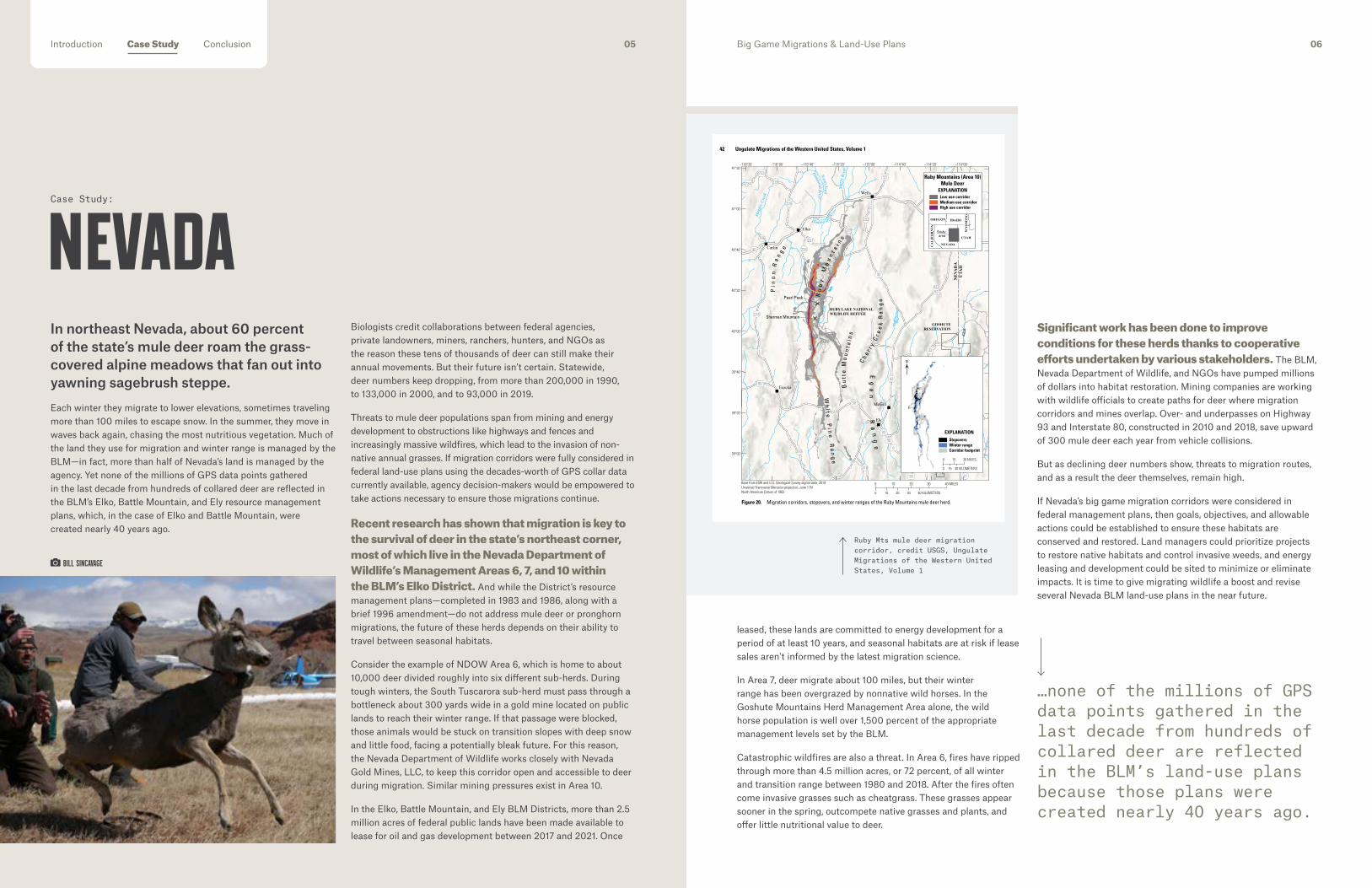
42 Ungulate Migrations of the Western United States, Volume 1
Figure 20. Migration corridors, stopovers, and winter ranges of the Ruby Mountains mule deer herd.
Base from ESRI and U.S. Geological Survey digital data, 2019Universal Transverse Mercator projection, zone 11NNorth American Datum of 1983
80
80
32
225
766
278
228
893
894318
379
892
487
21
159
227
229
232
233
226
GOSHUTERESERVATION
Carlin
Wendover
Ely
Eureka
Wells
Elko
UTA
HN
EVA
DA
724
723
93
93
93
93
50
50
50
50
6
6 6
93
93ALT
Mag
gie C
reek
Pi n
on
Ra
ng
e
Ru
by
M
ou
nt a
i ns
Humb oldt Ri
ver
North Fork
Humboldt River
Mar
ys R
iver
Ch e r r
y C
r ee
k R
an
ge
Bu
tte
Mo
un
t ai n
s
Eg
an
Ra
ng
e
McGill
RUBY LAKE NATIONALWILDLIFE REFUGE
Pearl Peak
Sherman Mountain
Wh
i t e P
i ne
Ra
ng
e
–116°20' –116°00' –115°40' –115°20' –115°00' –114°40' –114°20' –114°00'41°20'
41°00'
40°40'
40°20'
40°00'
39°40'
39°20'
39°00'
0 40 KILOMETERS10 20 30
0 10 20 30 40 MILES
Low use corridorMedium use corridorHigh use corridor
EXPLANATION
Ruby Mountains (Area 10)Mule Deer
IDAHOOREGON
Studyarea
NEVADA
UTAH
CA
LIF
OR
NIA
WY
OM
ING
0 30 KILOMETERS15
0 15 30 MILES
EXPLANATION
N
StopoversWinter rangeCorridor footprint
Ruby Mts mule deer migration corridor, credit USGS, Ungulate Migrations of the Western United States, Volume 1
BILL SINCAVAGE
…none of the millions of GPS data points gathered in the last decade from hundreds of collared deer are reflected in the BLM’s land-use plans because those plans were created nearly 40 years ago.
Big Game Migrations & Land-Use Plans 0605Introduction Case Study Conclusion

Case Study:
permitting and enforcement that is complicated by the absence of management direction where the corridors overlap with BLM- and USFS-administered public lands. While the Wyoming Game and Fish Department manages wildlife, they do not manage the federal lands that the wildlife use, and so these managers are left making recommendations to federal agencies.
The Baggs mule deer herd contains nearly 20,000 animals, and its migration corridor was one of three formally designated by the Wyoming Game and Fish Commission and the executive order. Tucked away in the south-central portion of the state, the routes traveled by these animals stretches south of Interstate 80 to the Colorado border.
The Baggs herd has two migratory units, one that summers on the Atlantic Rim before heading south to winter on an expanse of sagebrush and pinyon-juniper, and another that summers around the Sierra Madre range and heads south to Colorado. The area these deer cover is so large that it encompasses three hunt areas and portions of three counties—two in Wyoming and one in northern Colorado. Between 2,000 and 5,000 hunters pursue these deer each year with a success rate of more than 50 percent, making it one of the most heavily hunted mule deer populations in the state.
The deer spend much of their time navigating the extensive natural gas and wind energy developments that dot south-central Wyoming. Deer have also historically had trouble navigating traffic over Highway 789, though state officials recently installed two highway crossings and miles of game-proof fencing to facilitate safer passage.
The entire migration corridor is about 90 miles long and more than two-thirds of it is located on BLM land.
The opportunity to amend the BLM’s Rawlins Field Office resource management plan presents an important chance to ensure the Baggs migration corridor is conserved for future generations.
Finalized in 2008, the current BLM plan states that “surface disturbing and disruptive activities that are proposed in identified big game migration and transitional ranges will be managed, on a case-by-case basis.” Yet there is no reference to the formal corridor because the plan pre-dates modern migration research.
And while there are only a few threats to the Baggs herd—such as natural gas and wind energy developments—the scale of those threats is significant.
Given the Baggs corridor’s official state designation status, the mounting threats to this habitat, and more than a decade worth of migratory research on the herd, it is time for the BLM to take steps to update its management framework for the area. By amending the Rawlins resource management plan, the agency could develop the goals, objectives, and allowable actions necessary to ensure the conservation and enhancement of this herd, while balancing habitat needs with other uses of the land. It is simply not an option for the BLM to continue to make management decisions on “a case by case” basis when years of migratory research is readily available to inform consistent choices.
Wyoming, in many ways, pioneered modern-day big-game migration research in North America.Researcher Hall Sawyer discovered the 100-mile “Path of the Pronghorn,” which spans from the Upper Green River Valley all the way to Grand Teton National Park. Several years later, he documented the now-famous Red Desert to Hoback migration route, a 150-mile winding journey from the high plains of the Green River Basin to the mountains of northwest Wyoming.
Wyoming then became the first state to formally recognize big game migration corridors, supporting the science with management direction. Through this effort, and the associated state designation of corridors, conservation measures have been
applied to bottleneck areas—where the path of a corridor is narrow and constrained—and additional funding has been made available for habitat projects, research, and conservation.
The state prioritizes migration so much, in fact, that in early 2020, Governor Mark Gordon signed an executive order that directs state agencies to restrict activity in parts of mule deer and pronghorn corridors, while still respecting private property rights. Despite this emphasis, the federal land management plans governing large portions of the state still lack any reference to the actual migration corridors, let alone measures necessary to ensure their conservation and enhancement.
A governor’s executive order is, by its nature, limited to state policy, and does not directly result in changes to federal policy. As a result, Wyoming’s migration executive order sets up a juggling act for
WYOMING
50 Ungulate Migrations of the Western United States, Volume 1
Figure 24. WGFD Designated Corridor, stopovers and routes of the Baggs mule deer herd.
789
76789
789
789
71
287
3030
COLORADOWYOMING
80 80
Rawlins
Sinclair
401
70
13
Baggs Dixon
Atlant
ic Ri
m
The SandHills
Si e r r a M
ad
r e
North
Platt
e Rive
r
ElkheadMountains
Littl
e Sna
ke River
Mud
dy C
reek
Sa
very
Cre
ek
SummerRange
SummerRange
SummerRange
WinterRange
WinterRange
WinterRange
41°40'
41°20'
41°00'
40°40'
−107°00'−107°20'−107°40'−108°00'
Base from ESRI, U.S. Geological Survey, National Park Service, and U.S. Census Bureau digital data, 2019Universal Transverse Mercator projection, zone 13NNorth American Datum of 1983
0 15 KILOMETERS5 10
0 5 10 15 MILES
WYOMING
COLORADOUTAH
Studyarea
StopoversWyoming Game and Fish Department designated corridor
EXPLANATION
Baggs Mule DeerCorridor
EXPLANATION
0 20 KILOMETERS10
0 10 20 MILES
N
Wyoming Game and Fish Department designated corridor boundary
Atlantic Rim South routesAtlantic Rim North routes
Baggs mule deer migration corridor, credit USGS, Ungulate Migrations of the Western United States, Volume 1
TANNER WARDEN/WYOMING MIGRATION INITIATIVE
…it is simply not an option for the BLM to continue to make management decisions on “a case by case” basis, when years of migratory research is readily available to inform the agency’s future decision making.
Big Game Migrations & Land-Use Plans 0807Introduction Case Study Conclusion

Case Study:
As of early 2021, four mule deer migrations have been mapped in the Salmon-Challis National Forest.
The Antelope Creek migration arcs more than 42 miles from summer range in the Smoky Mountains, just north of Sun Valley, to winter range near the Big Lost River. Between 1,300 and 1,850 deer winter in the area. Illegally developed trails, ever-increasing recreation, and fragmentation of native habitat continue to whittle down their range.
The Centennial Flat herd migrates from its namesake winter range at the foothills of the Challis near the Salmon River to the remote areas of the Salmon River Mountains. Almost 3,400 deer migrate along this roughly 30-mile corridor.
On average, the Morgan Creek herd travels about 25 miles from winter to summer ranges, but some deer journey more than 85 miles up into the Salmon River Mountains.
Lastly, the Mt. Borah herd winters alongside elk, pronghorn, and bighorn sheep on the flats at the base of the Lost River Range. The deer travel about 50 miles, following the Big Lost River drainage to reach their summer range north of Ketchum.
By the end of 2021, wildlife officials are expected to unveil several newly identified migration routes that intersect with the Salmon-Challis National Forest. There are likely more that have not yet been discovered through research.
At the same time, threats to migration in the national forest loom on the horizon, from development to old fences to new roads and trails to ever-increasing human presence. The Forest Service has management tools available to them that could reduce current and future threats. In 2016, local Forest Service staff started considering ways to prioritize wildlife in a new forest plan. They worked with county governments, conservation groups, and others on the early phase of a revision to the forest plan. But those efforts stalled in 2019.
Instead of waiting for herd sizes to dwindle, the Salmon-Challis National Forest planning process needs to restart and move forward toward completion. Informed by the latest migration data, updated plans could lay out a process to conserve and enhance migrations over time as new information becomes available, set goals for replacing or removing fencing that impedes migration, and guide recreation management to account for the needs of big game and other wildlife.
The multitude of mountain ranges in Idaho’s Salmon-Challis National Forest encompass the wild center of the state and stretch south like fingers toward the Snake River Plain. The Beaverhead, Lemhi, Lost River, and Pioneer ranges begin near the Frank Church-River of No Return Wilderness, the largest contiguous wilderness area in the Lower 48. And thousands of mule deer migrate in and among those rugged mountains each spring and fall. In fact, four of Idaho’s 12 identified migration routes wind across the Salmon-Challis.
The land management plan for the forest, however, does not consider or acknowledge any of these mapped routes. Written in the late 1980s, it offers zero guidance for how to manage lands with wildlife on the move.
Today, the landscape is under new pressures from Idaho’s astonishing population growth, posing a threat to the functionality of the intact, unfragmented habitats that support the Salmon-Challis’ deer herds, which are numerous enough that many have not yet been mapped.
The Salmon-Challis National Forest occupies a swath of rugged land in Idaho where development has largely remained on the fringes. The fact that portions of the area are either part of, or adjacent to, the Central Idaho Dark Skies Reserve, is testament to the region’s low residential density. Because of its uniquely intact, wild landscapes, this area provides habitat for a wide array of big game, from elk, deer, and bighorn sheep to mountain goats and moose.
But Idaho, along with much of the West, is experiencing an explosion of growth. Between April 2010 and July 2020, its population grew by 16 percent and the West’s as a whole grew by 9 percent.
Many of these newcomers are attracted to outdoor recreation opportunities and wide, undeveloped landscapes in places like the Salmon-Challis. They seek out the views, experiences, and wildlife that make these places unique, but without a forest plan to manage the impacts of increased public land-use on migrating herds, big game populations could suffer.
IDAHO
Mule deer migration routes associated with the Salmon-Challis, credit IDFG
…Newcomers to the region seek out the views, experiences, and wildlife that make these places unique, but without a forest plan to manage the impacts of increased public land-use on migrating herds, big game populations could suffer.
TOM KOERNER/USFWS
Big Game Migrations & Land-Use Plans 1009Introduction Case Study Conclusion

Case Study: Case Study:
Colorado Parks and Wildlife has a relatively simple solution for conserving the state’s big game populations: Limit the density of development in the highest priority big game habitats, including migration corridors, so that they continue to function. That means limiting the density of oil and gas facilities, roads, trails, and other development pressures.It could be as close to a win-win as is possible in a landscape marred by increased conflict between wildlife, trail-based recreation, and energy development. But the BLM is hamstrung, its officials say, due to outdated plans that don’t allow for those kinds of stipulations.
Indeed, the plans for 10 BLM field offices spanning important big game habitat across much of the state are outdated. None of them include recent migration data, and fewer than half include much management for migration at all. Fortunately, in 2019, the BLM assured Colorado’s wildlife agency that it will update all its plans to include migration science and best management practices.
With updated plans, the BLM could maintain two of Colorado’s main economic drivers—energy development and outdoor recreation—while also helping conserve its world-famous migratory herds.
Because wildlife tourism is so central to Colorado’s economy and will only increase in importance in the next decade, healthy herds are essential. In 2017, hunting, fishing, and wildlife-watching activities in Colorado spurred $5 billion in economic output and helped to support rural communities.
By initiating a statewide plan amendment in the coming year—in coordination with state wildlife experts—the BLM could create the tools it needs to ensure the persistence of valuable migratory habitats on public lands.
Mountains within the Lolo and Bitterroot National Forests are known for their rugged peaks, timbered canyons, and abundant wildlife populations. Bighorn sheep roam the rocky slopes, and elk and mule deer travel from the high country to their winter ranges and back again each year. Recently, Montana Fish, Wildlife & Parks has analyzed GPS collar information to gain a clear understanding of wildlife movements in these forests and elsewhere in the state.
But the U.S. Forest Service land-use plans covering these vast acreages were written 35 years ago, when the local human population was much smaller, commercial timber harvest reigned supreme, and there was far less information on how wildlife moved across the landscape.
Now, a seemingly limitless demand for outdoor recreation opportunities, the growing presence of noxious weeds, and forests stressed by decades of fire suppression and warming conditions are putting pressure on wildlife and habitat. Simultaneously, exploding urban development continues to eat into winter and transitional ranges on private lands.
The Lolo and Bitterroot National Forests land-use plans should be updated to address these challenges on public land. New information about wildlife migrations that has been collected through years of collaring should help the agency set objectives, standards, and guidelines in the forest plan to conserve and enhance these important habitats for decades to come.
COLORADO MONTANA
JOE LEWANDOWSKI
Big Game Migrations & Land-Use Plans 1211Introduction Case Study Conclusion
MIKE THOMPSON/MTFWP
…the BLM is hamstrung, its officials say, due to outdated plans that don’t allow for those kinds of stipulations.
…the U.S. Forest Service land-use plans covering these vast acreages were written 35 years ago, when the local human population was much smaller and there was far less information on how wildlife moved across the landscape.

Big Game Migrations & Land-Use Plans 14
In 2018, the U.S. Geological Survey’s Cooperative Fish and Wildlife Research Unit began an ambitious project, working with biologists and wildlife managers in various state and tribal agencies to assemble a comprehensive reference of the most up-to-date GPS research on bison, elk, moose, mule deer, and pronghorn migrations.The first product of that effort was published in 2020 as Ungulate Migrations of the Western United States, Volume 1. The atlas depicts 26 corridors, 16 migration routes, 25 stopovers, and nine winter ranges across five Western states: Arizona, Idaho, Nevada, Utah, and Wyoming. In many ways, this book—which has earned widespread acclaim—embodies our rapidly advancing collective understanding of big game migrations.
States across the West have led the way in providing government officials, wildlife and land managers, conservation groups, and private landowners a consistent, ever-expanding set of scientific data to help inform decision-making and management. This invaluable information – created by scholars and wildlife officials working hand-in-hand – not only shows where big game animals move, it offers a highly detailed portrait of how they use the landscape and what herds need to successfully complete these journeys.
When combined with decades of good data gathered using older technologies, the institutional memory of veteran wildlife managers, and tribal knowledge, modern GPS collar data can provide our federal land management agencies with a vast, well-established body of information that can influence land-use decisions to conserve big game herds.
These resources impose no specific policy mandates; rather, science and local knowledge allow people and agencies to make better-informed decisions about how lands should be managed. This can guide the siting of projects permitted for development on public lands and help prioritize investments in voluntary conservation and restoration opportunities on private lands. And this information will only continue to expand and improve.
Several states continue to unveil new maps of migration corridors as data becomes available, and some states already have collar data in hand, awaiting analysis. The results will bring into focus migrations that may have, until now, been largely invisible or only understood through anecdotal observations.
And yet our federal land management agencies will remain deprived of this critical information’s full benefit until the plans that guide their decision-making are updated. Saddled with land-use plans drafted decades prior to the evolution of GPS technology, they operate under administrative frameworks that do not acknowledge or manage for the specific needs of migratory animals. Until guidance specific to big game migration is included in these plans, land managers cannot tackle one of the most pressing conservation challenges facing some of the West’s most iconic animals.
Once updated, however, plans would offer clear direction to ensure migration corridors aren’t overlooked and empower decision-makers to mitigate chronic impediments to animal movement, like roadways and old fences. They could utilize current science to minimize and avoid development impacts, such as by applying restrictions on surface disturbance in bottleneck areas or development density restrictions in stopover areas. Federal dollars and conservation grants could be freed up for habitat restoration. Treatments could be prioritized in areas facing invasive grasses or conifer encroachment. And managers could have the flexibility to conserve and enhance additional routes as they are mapped over time.
Looking to the future, we can be certain that states and tribes across the West will continue to identify new migration routes across the mountains, prairies, deserts, and other landscapes that make the region unique. We can also be certain that while our understanding of how herds utilize seasonal habitats will improve, the pressures and threats facing those animals will increase. For that reason, it is imperative that federal land management agencies embrace their roles as collaborative partners with other stakeholders on this issue, using the best-available science and cooperating with state and tribal officials who in many cases have already identified and prioritized the work ahead. Only then will decision-makers have an opportunity to fulfill their multiple-use mandates and conserve these important habitats—as well as the iconic species that depend on them—for decades to come.
LOOKING TOWARD THE FUTURE.
CRAIG OKRASKA/MAVEN
Introduction Case Study Conclusion 13

A list of literature referenced in this report can be found at trcp.org/workscited.
The Theodore Roosevelt Conservation Partnership is a coalition of leading hunting, fishing, and conservation organizations, individual grassroots partners, and outdoor related businesses. Our mission is to guarantee all Americans quality places to hunt and fish. The TRCP works with its partners to preserve the traditions of hunting and fishing in
America by expanding access, conserving fish and wildlife habitat, and increasing funding for conservation and wildlife management.
ABOUT TRCP
JOSH METTENCOVER:BILL SINCAVAGE