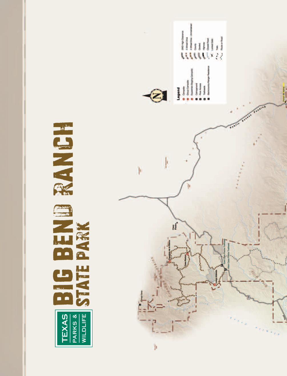
Big Bend Ranch SP Map Road el SOLitarIo Pages 6 … · the River Road Page 12 Big Bend Ranch SP Map...
12
TEXAS PARKS AND WILDLIFE Fort Leaton Furnished Page 11 Bighorn Sheep Return Page 10 Table of contents El Solitario is published by the Texas Parks and Wildlife Department for the orientation and education of visitors to Big Bend Ranch State Park. Compadres del Rancho Grande 2 Be Aware 3 Featured Campsites 3 Certified Commercial Guides and Outfitters 3 Featured Hike 4 Fees and Visitor Services 5 Big Bend Ranch State Park Map 6 Access and Visitor Services 8 Make the Most of Your Visit 9 The Return of the Native 10 Fort Leaton Comes to Life 11 The River Road: Trail of Treasures 12 el S O LitarIo Explore the River Road Page 12 Big Bend Ranch SP Map Pages 6 — 7 By Gary Nored Each season of the year holds its own set of wonders at Big Bend Ranch State Park and draws visitors from all walks of life: tourists, hikers, campers, naturalists, and sports enthusiasts. Photographers love it, too. Fall and winter are perhaps the most popular seasons, when cool, sunny days abound and the palette is composed mostly of earth tones. Springtime is marked by the brilliance of cacti, ocotillo and yucca erupting into flower, a precursor of the summer rainy season when the desert really comes to life. No matter the time of your visit, you will experience stunning landscapes and expansive skies. Here are some ideas to help you get the best pictures possible during your visit. TEXAS PARKS AND WILDLIFE DEPARTMENT | 2012 ISSUE | BIG BEND RANCH STATE PARK Walk No matter what your skill level or quality of equipment, there’s nothing you can do that will net you better pictures than getting out of the car and walking. You needn’t go on long hikes— beautiful pictures are often only a few car lengths away. The smallest, driest creekbeds frequently turn into amazing canyons “just around the bend.” Dramatic cliff and hilltop vistas are easily reachable from every road in the park. Scout Locations Movie makers and professional photographers often spend a lot of time “scouting locations.” They are thinking about the pictures they would like to take, and at what times of the day the pictures would look the best. You can do the same thing. Pay attention to the sun and how the shadows lie. Try to imagine how the sun will traverse the sky and what will happen to the scene during the course of the day. Carry a compass and note the direction in which features lie. Make notes and come back later to verify your guesses. If you were right, take the picture and congratulate yourself on having “scouted” a great location. Photographing Big Bend Ranch State Park © Gary Nored (cont. on page 2) Stunning photo opportunities await you at Big Bend Ranch State Park.
Transcript of Big Bend Ranch SP Map Road el SOLitarIo Pages 6 … · the River Road Page 12 Big Bend Ranch SP Map...
T E X A S P A R K S A N D W I L D L I F E
Fort LeatonFurnishedPage 11
BighornSheepReturnPage 10
Table ofcontents
El Solitario is published by the Texas Parks and Wildlife Department for the orientation and education of visitors to Big Bend Ranch State Park.
Compadres del Rancho Grande . . . . . . . . . . . . . . 2
Be Aware . . . . . . . . . . . . . . . . . . . . . . . . . . . . . . . . . 3
Featured Campsites . . . . . . . . . . . . . . . . . . . . . . . . 3
Certified Commercial Guides and Outfitters . . . 3
Featured Hike . . . . . . . . . . . . . . . . . . . . . . . . . . . . . 4
Fees and Visitor Services . . . . . . . . . . . . . . . . . . . 5
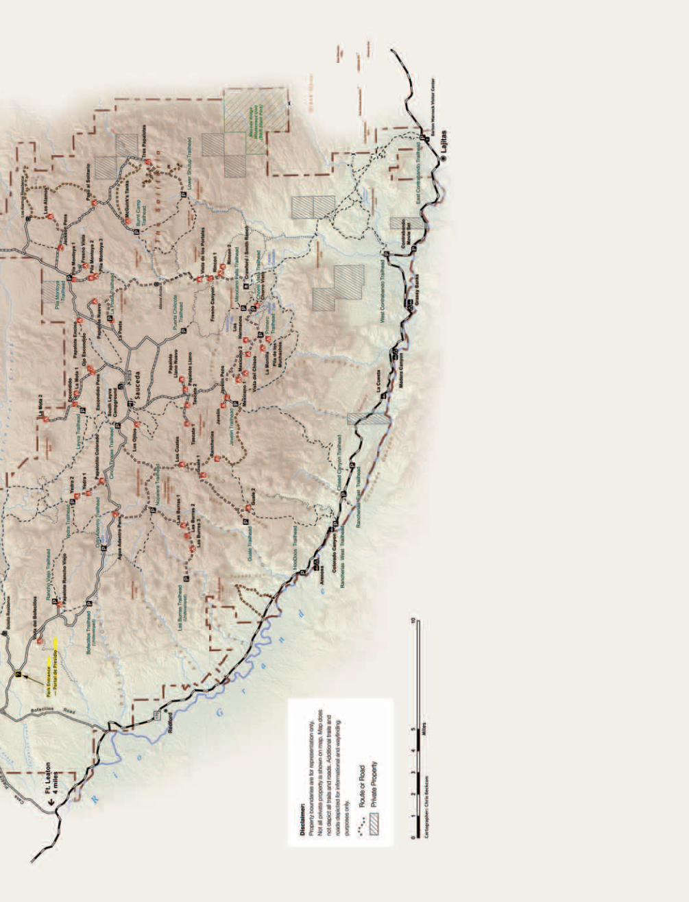
Big Bend Ranch State Park Map . . . . . . . . . . . . 6
Access and Visitor Services . . . . . . . . . . . . . . . . 8
Make the Most of Your Visit . . . . . . . . . . . . . . . . 9
The Return of the Native . . . . . . . . . . . . . . . . . 10
Fort Leaton Comes to Life . . . . . . . . . . . . . . . . . 11
The River Road: Trail of Treasures . . . . . . . . . 12
el SOLitarIoExplore the River RoadPage 12
Big Bend Ranch SP MapPages 6 — 7
By Gary Nored
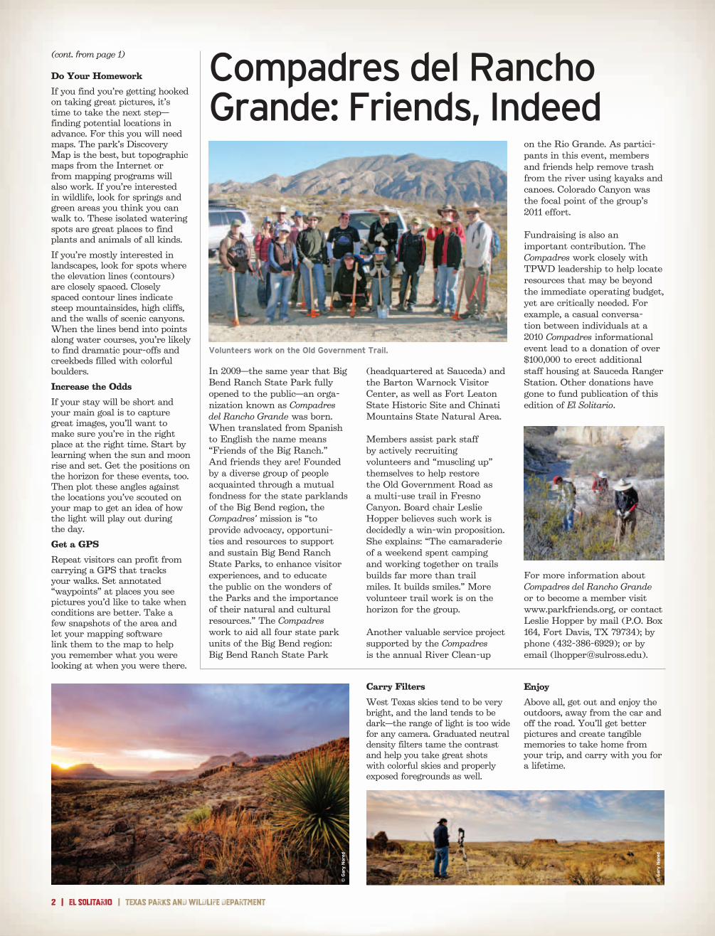
Each season of the year holds its own set of wonders at Big Bend Ranch State Park and draws visitors from all walks of life: tourists, hikers, campers, naturalists, and sports enthusiasts. Photographers love it, too. Fall and winter are perhaps the most popular seasons, when cool, sunny days abound and the palette is composed mostly of earth tones. Springtime is marked by the brilliance of cacti, ocotillo and yucca erupting into flower, a precursor of the summer rainy season when the desert really comes to life. No matter the time of your visit, you will experience stunning landscapes and expansive skies. Here are some ideas to help you get the best pictures possible during your visit.
T e x a s P a r k s a n d W i l d l i f e d e P a r T m e n T | 2 0 1 2 i s s U e | B i g B e n d r a n c h s T a T e P a r k
Walk
No matter what your skill level or quality of equipment, there’s nothing you can do that will net you better pictures than getting out of the car and walking. You needn’t go on long hikes— beautiful pictures are often only a few car lengths away. The smallest, driest creekbeds frequently turn into amazing canyons “just around the bend.” Dramatic cliff and hilltop vistas are easily reachable from every road in the park.
Scout Locations
Movie makers and professional photographers often spend a lot of time “scouting locations.” They are thinking about the pictures they would like to take, and at what times of the day the pictures would look the best. You can do the same thing. Pay attention to the sun and how the shadows lie. Try to imagine how the sun will traverse the sky and what will happen to the scene during the course of the day.
Carry a compass and note the direction in which features lie. Make notes and come back later to verify your guesses. If you
were right, take the picture and congratulate yourself on having “scouted” a great location.
Photographing Big Bend Ranch State Park
© G
ary N
ored
(cont. on page 2)
Stunning photo opportunities await you at Big Bend Ranch State Park.
2 | el SOLitarIo | Texas parks and wildlife department
Compadres del Rancho Grande: Friends, Indeed
on the Rio Grande. As partici-pants in this event, members and friends help remove trash from the river using kayaks and canoes. Colorado Canyon was the focal point of the group’s 2011 effort.
Fundraising is also an important contribution. The Compadres work closely with TPWD leadership to help locate resources that may be beyond the immediate operating budget, yet are critically needed. For example, a casual conversa-tion between individuals at a 2010 Compadres informational event lead to a donation of over $100,000 to erect additional staff housing at Sauceda Ranger Station. Other donations have gone to fund publication of this edition of El Solitario.
For more information about Compadres del Rancho Grande or to become a member visit www.parkfriends.org, or contact Leslie Hopper by mail (P.O. Box 164, Fort Davis, TX 79734); by phone (432-386-6929); or by email ([email protected]).
Do Your Homework
If you find you’re getting hooked on taking great pictures, it’s time to take the next step— finding potential locations in advance. For this you will need maps. The park’s Discovery Map is the best, but topographic maps from the Internet or from mapping programs will also work. If you’re interested in wildlife, look for springs and green areas you think you can walk to. These isolated watering spots are great places to find plants and animals of all kinds.
If you’re mostly interested in landscapes, look for spots where the elevation lines (contours) are closely spaced. Closely spaced contour lines indicate steep mountainsides, high cliffs, and the walls of scenic canyons. When the lines bend into points along water courses, you’re likely to find dramatic pour-offs and creekbeds filled with colorful boulders.
Increase the Odds
If your stay will be short and your main goal is to capture great images, you’ll want to make sure you’re in the right place at the right time. Start by learning when the sun and moon rise and set. Get the positions on the horizon for these events, too. Then plot these angles against the locations you’ve scouted on your map to get an idea of how the light will play out during the day.
Get a GPS
Repeat visitors can profit from carrying a GPS that tracks your walks. Set annotated “waypoints” at places you see pictures you’d like to take when conditions are better. Take a few snapshots of the area and let your mapping software link them to the map to help you remember what you were looking at when you were there.
(headquartered at Sauceda) and the Barton Warnock Visitor Center, as well as Fort Leaton State Historic Site and Chinati Mountains State Natural Area.
Members assist park staff by actively recruiting volunteers and “muscling up” themselves to help restore the Old Government Road as a multi-use trail in Fresno Canyon. Board chair Leslie Hopper believes such work is decidedly a win-win proposition. She explains: “The camaraderie of a weekend spent camping and working together on trails builds far more than trail miles. It builds smiles.” More volunteer trail work is on the horizon for the group.
Another valuable service project supported by the Compadres is the annual River Clean-up
In 2009—the same year that Big Bend Ranch State Park fully opened to the public—an orga-nization known as Compadres del Rancho Grande was born. When translated from Spanish to English the name means “Friends of the Big Ranch.” And friends they are! Founded by a diverse group of people acquainted through a mutual fondness for the state parklands of the Big Bend region, the Compadres’ mission is “to provide advocacy, opportuni-ties and resources to support and sustain Big Bend Ranch State Parks, to enhance visitor experiences, and to educate the public on the wonders of the Parks and the importance of their natural and cultural resources.” The Compadres work to aid all four state park units of the Big Bend region: Big Bend Ranch State Park
(cont. from page 1)
Volunteers work on the Old Government Trail.
Carry Filters
West Texas skies tend to be very bright, and the land tends to be dark—the range of light is too wide for any camera. Graduated neutral density filters tame the contrast and help you take great shots with colorful skies and properly exposed foregrounds as well.
Enjoy
Above all, get out and enjoy the outdoors, away from the car and off the road. You’ll get better pictures and create tangible memories to take home from your trip, and carry with you for a lifetime.
© G
ary N
ored
© G
ary N
ored
big bend ranch state park | el SOLitarIo | 3
Many wonderful animals live here and play a vital role in the balance of nature. You are a guest in their home. By learning about the park’s animals and observing the following tips, you can show them the respect they deserve while keeping yourself and your family safe.
Rattlesnakes are especially common at Big Bend Ranch. Watch where you put your hands and feet. Never harass or attempt to handle a rattlesnake—this is when most bites occur. Rattlesnakes are protected in the park; do them no harm.
Never feed wild animals or allow them to get human or pet food.
Observe wild animals and longhorn cattle from a safe distance; never approach or try to photograph them at close range.
Keep children and pets under your control at all times.
Clean up and store food and garbage immediately after meals; never keep food in your tent.
Enjoy the outdoors with others, not alone.
In the unlikely event that you encounter a black bear or mountain lion, do not run. Instead, face the animal, make noise and try to look as large as possible. Pick up small children. Back away slowly. If attacked, fight back. Report sightings to park staff immediately.
BE AWARE:For your safety and welfare
Western Diamondback
rattlesnake
Ear
l N
otti
ngh
am
In the unlikely event that a snake bite occurs:
• Remove jewelry and loosen tight-fitting clothing .
• Wash the bite area with disinfectant .
• Keep the person calm and quiet .
• Limit movement if at all possible .
• Watch for symptoms of shock .
• Seek medical attention immediately .
+
Local outfitters can provide
guides and assist you with
equipment needs . Potential
services include nature
hikes, mountain bike tours,
horseback rides, river trips
and campouts .
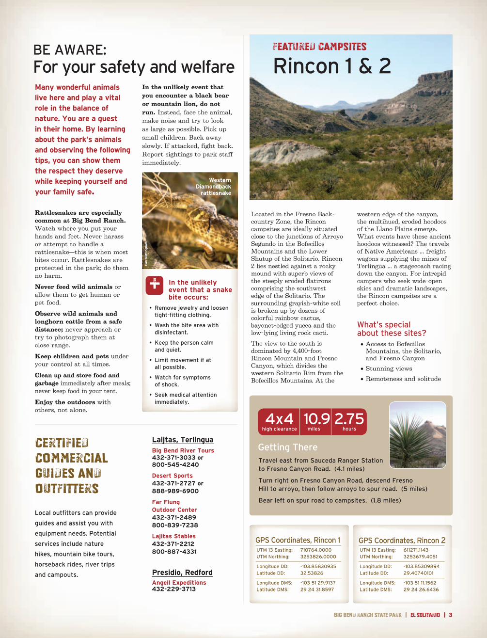
Located in the Fresno Back-country Zone, the Rincon campsites are ideally situated close to the junctions of Arroyo Segundo in the Bofecillos Mountains and the Lower Shutup of the Solitario. Rincon 2 lies nestled against a rocky mound with superb views of the steeply eroded flatirons comprising the southwest edge of the Solitario. The surrounding grayish-white soil is broken up by dozens of colorful rainbow cactus, bayonet-edged yucca and the low-lying living rock cacti.
The view to the south is dominated by 4,400-foot Rincon Mountain and Fresno Canyon, which divides the western Solitario Rim from the Bofecillos Mountains. At the
western edge of the canyon, the multihued, eroded hoodoos of the Llano Plains emerge. What events have these ancient hoodoos witnessed? The travels of Native Americans ... freight wagons supplying the mines of Terlingua ... a stagecoach racing down the canyon. For intrepid campers who seek wide-open skies and dramatic landscapes, the Rincon campsites are a perfect choice.
What’s special about these sites? • Access to Bofecillos
Mountains, the Solitario, and Fresno Canyon
• Stunning views
• Remoteness and solitude
UTM 13 Easting: 710764 .0000 UTM Northing: 3253826 .0000
Longitude DD: -103 .85830935 Latitude DD: 32 .53826
Longitude DMS: -103 51 29 .9137 Latitude DMS: 29 24 31 .8597
GPS Coordinates, Rincon 1UTM 13 Easting: 611271 .1143 UTM Northing: 3253679 .4051
Longitude DD: -103 .85309894 Latitude DD: 29 .40740101
Longitude DMS: -103 51 11 .1562 Latitude DMS: 29 24 26 .6436
GPS Coordinates, Rincon 2
Getting There
10 .9 2 .75 miles hours
4x4high clearance
Featured Campsites
Rincon 1 & 2
Certified Commercial Guides and Outfitters
Laijtas, TerlinguaBig Bend River Tours 432-371-3033 or 800-545-4240
Desert Sports 432-371-2727 or 888-989-6900
Far Flung Outdoor Center 432-371-2489 800-839-7238
Lajitas Stables 432-371-2212 800-887-4331
Presidio, RedfordAngell Expeditions 432-229-3713
Travel east from Sauceda Ranger Station to Fresno Canyon Road . (4 .1 miles)
Turn right on Fresno Canyon Road, descend Fresno Hill to arroyo, then follow arroyo to spur road . (5 miles)
Bear left on spur road to campsites . (1 .8 miles)
4 | el SOLitarIo | Texas parks and wildlife department
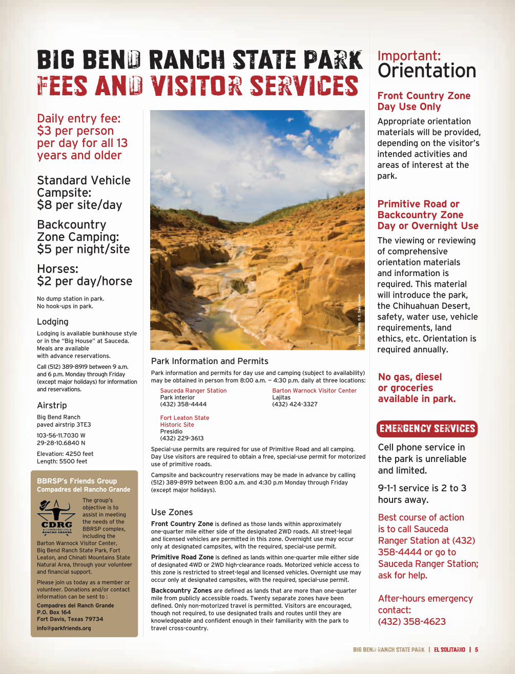
Contrabando Multi-Use Trail has two trailheads, one located directly across the highway from the Barton Warnock Visitor Center near Lajitas and a second located 7.5 miles to the west along F.M. 170. Regardless of your skill level, this 25-mile trail system offers a segment or side loop that is suitable for you — from novice to advanced. Watch for horses: this trail is open to equestrians too. Enjoy spectacular views as you encircle the red rock of Lajitas Mesa or the uplifted Contrabando Dome. Along the trail, watch for wayside exhibits that interpret the area’s mining and ranching heritage.
The word “contrabando” is Spanish for “contraband.” For decades, smugglers traversed what is now known as the Contrabando region along the eastern boundary of Big Bend Ranch State Park. In the early 1900s, area ranchers sought Mexican cattle to bolster their herds; some brought animals across the border illegally to avoid custom fees. During the 1930s, huge amounts of candelilla wax slipped across the border as well. Wax smugglers escaped heavy Mexican export taxes and profited from higher prices in the U.S. Then, during prohibition, mule trains brought great quantities of sotol, an alcoholic beverage, out of Mexico to the U.S. border, where it was delivered to bootleggers.
MOUNTAIN BIKINGContrabando multi-use and Horsetrap bike-and-hike
Horsetrap Bike- and-Hike Trail is easily accessible from Sauceda. Hikers will find the trail an easy five-mile loop with vistas of the surrounding Chihuahuan Desert. For mountain bikers the degree of difficulty ranges from moderate to downright challenging. A 200-yard portion of the trail is sandy. Enjoy this “off the beaten path” experience as you soak up the solitude and the scenery.
25 miles
5 miles
FEATURED HIKEPuerta Chilicote Trailhead to Fresno Canyon/Flatirons Vista
Backcountry Zone Camping
There are no designated campsites in the backcountry zone . Backcountry camping allows overnight visitors to select their own primitive campsite, based upon certain conditions:
• At least 1/4 mile from any other existing campsite
• At least 300 feet from water sources and prehistoric or historic cultural sites
• At least 3/4 mile from trailheads or roads
Backcountry campers may use the “cathole” method to dispose of human waste and must pack out all trash . No open fires are allowed due to resource impact; use of containerized fuel stoves is permitted . The maximum stay is 14 nights (total) and seven consecutive days in any one backcountry zone .
Views of Contrabando Waterhole and ruins from a 1890s ranch await you on the Contrabando Trail.
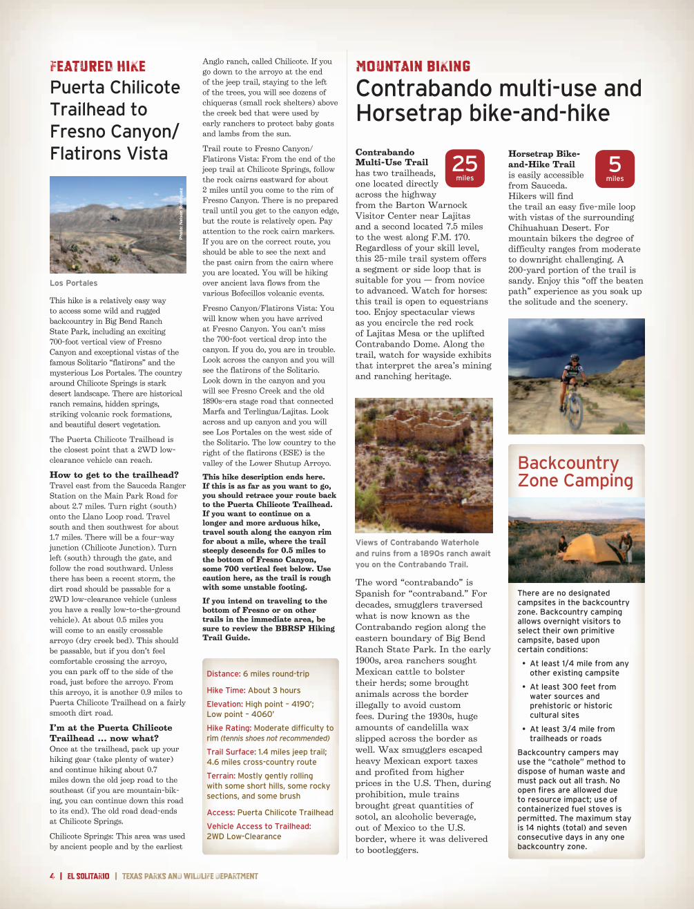
This hike is a relatively easy way to access some wild and rugged backcountry in Big Bend Ranch State Park, including an exciting 700-foot vertical view of Fresno Canyon and exceptional vistas of the famous Solitario “flatirons” and the mysterious Los Portales. The country around Chilicote Springs is stark desert landscape. There are historical ranch remains, hidden springs, striking volcanic rock formations, and beautiful desert vegetation.
The Puerta Chilicote Trailhead is the closest point that a 2WD low-clearance vehicle can reach.
How to get to the trailhead?Travel east from the Sauceda Ranger Station on the Main Park Road for about 2.7 miles. Turn right (south) onto the Llano Loop road. Travel south and then southwest for about 1.7 miles. There will be a four-way junction (Chilicote Junction). Turn left (south) through the gate, and follow the road southward. Unless there has been a recent storm, the dirt road should be passable for a 2WD low-clearance vehicle (unless you have a really low-to-the-ground vehicle). At about 0.5 miles you will come to an easily crossable arroyo (dry creek bed). This should be passable, but if you don’t feel comfortable crossing the arroyo, you can park off to the side of the road, just before the arroyo. From this arroyo, it is another 0.9 miles to Puerta Chilicote Trailhead on a fairly smooth dirt road.
I’m at the Puerta Chilicote Trailhead … now what?Once at the trailhead, pack up your hiking gear (take plenty of water) and continue hiking about 0.7 miles down the old jeep road to the southeast (if you are mountain-bik-ing, you can continue down this road to its end). The old road dead-ends at Chilicote Springs.
Chilicote Springs: This area was used by ancient people and by the earliest
Anglo ranch, called Chilicote. If you go down to the arroyo at the end of the jeep trail, staying to the left of the trees, you will see dozens of chiqueras (small rock shelters) above the creek bed that were used by early ranchers to protect baby goats and lambs from the sun.
Trail route to Fresno Canyon/Flatirons Vista: From the end of the jeep trail at Chilicote Springs, follow the rock cairns eastward for about 2 miles until you come to the rim of Fresno Canyon. There is no prepared trail until you get to the canyon edge, but the route is relatively open. Pay attention to the rock cairn markers. If you are on the correct route, you should be able to see the next and the past cairn from the cairn where you are located. You will be hiking over ancient lava flows from the various Bofecillos volcanic events.
Fresno Canyon/Flatirons Vista: You will know when you have arrived at Fresno Canyon. You can’t miss the 700-foot vertical drop into the canyon. If you do, you are in trouble. Look across the canyon and you will see the flatirons of the Solitario. Look down in the canyon and you will see Fresno Creek and the old 1890s-era stage road that connected Marfa and Terlingua/Lajitas. Look across and up canyon and you will see Los Portales on the west side of the Solitario. The low country to the right of the flatirons (ESE) is the valley of the Lower Shutup Arroyo.
This hike description ends here. If this is as far as you want to go, you should retrace your route back to the Puerta Chilicote Trailhead. If you want to continue on a longer and more arduous hike, travel south along the canyon rim for about a mile, where the trail steeply descends for 0.5 miles to the bottom of Fresno Canyon, some 700 vertical feet below. Use caution here, as the trail is rough with some unstable footing.
If you intend on traveling to the bottom of Fresno or on other trails in the immediate area, be sure to review the BBRSP Hiking Trail Guide.
Los Portales
Phot
o: N
elso
n R
odri
guez
Distance: 6 miles round-trip
Hike Time: About 3 hours
Elevation: High point – 4190’; Low point – 4060’
Hike Rating: Moderate difficulty to rim (tennis shoes not recommended)
Trail Surface: 1 .4 miles jeep trail; 4 .6 miles cross-country route
Terrain: Mostly gently rolling with some short hills, some rocky sections, and some brush
Access: Puerta Chilicote Trailhead
Vehicle Access to Trailhead: 2WD Low-Clearance
big bend ranch state park | el SOLitarIo | 5
Daily entry fee: $3 per person per day for all 13 years and older
Standard Vehicle Campsite: $8 per site/day
Backcountry Zone Camping: $5 per night/site
Horses: $2 per day/horseNo dump station in park . No hook-ups in park .
LodgingLodging is available bunkhouse style or in the “Big House” at Sauceda . Meals are available with advance reservations .
Call (512) 389-8919 between 9 a .m . and 6 p .m . Monday through Friday (except major holidays) for information and reservations .
AirstripBig Bend Ranch paved airstrip 3TE3
103-56-11 .7030 W 29-28-10 .6840 N
Elevation: 4250 feet Length: 5500 feet
Park Information and PermitsPark information and permits for day use and camping (subject to availability) may be obtained in person from 8:00 a .m . — 4:30 p .m . daily at three locations:
Sauceda Ranger Station Barton Warnock Visitor Center Park interior Lajitas (432) 358-4444 (432) 424-3327 Fort Leaton State Historic Site Presidio (432) 229-3613
Special-use permits are required for use of Primitive Road and all camping . Day Use visitors are required to obtain a free, special-use permit for motorized use of primitive roads .
Campsite and backcountry reservations may be made in advance by calling (512) 389-8919 between 8:00 a .m . and 4:30 p .m Monday through Friday (except major holidays) .
Use ZonesFront Country Zone is defined as those lands within approximately one-quarter mile either side of the designated 2WD roads . All street-legal and licensed vehicles are permitted in this zone . Overnight use may occur only at designated campsites, with the required, special-use permit .
Primitive Road Zone is defined as lands within one-quarter mile either side of designated 4WD or 2WD high-clearance roads . Motorized vehicle access to this zone is restricted to street-legal and licensed vehicles . Overnight use may occur only at designated campsites, with the required, special-use permit .
Backcountry Zones are defined as lands that are more than one-quarter mile from publicly accessible roads . Twenty separate zones have been defined . Only non-motorized travel is permitted . Visitors are encouraged, though not required, to use designated trails and routes until they are knowledgeable and confident enough in their familiarity with the park to travel cross-country .
Big Bend Ranch State ParkFees and visitor services
Important:OrientationFront Country Zone Day Use Only
Appropriate orientation materials will be provided, depending on the visitor’s intended activities and areas of interest at the park .
Primitive Road or Backcountry Zone Day or Overnight Use
The viewing or reviewing of comprehensive orientation materials and information is required . This material will introduce the park, the Chihuahuan Desert, safety, water use, vehicle requirements, land ethics, etc . Orientation is required annually .
No gas, diesel or groceriesavailable in park.
Cell phone service in the park is unreliable and limited .
9-1-1 service is 2 to 3hours away .
Best course of action is to call Sauceda Ranger Station at (432) 358-4444 or go to Sauceda Ranger Station; ask for help .
After-hours emergency contact:(432) 358-4623
Emergency services
Fre
sno
Can
yon
, © E
. Dan
Kle
pper
BBRSP’s Friends GroupCompadres del Rancho Grande
The group’s objective is to assist in meeting the needs of the BBRSP complex, including the
Barton Warnock Visitor Center, Big Bend Ranch State Park, Fort Leaton, and Chinati Mountains State Natural Area, through your volunteer and financial support .
Please join us today as a member or volunteer . Donations and/or contact information can be sent to :
Compadres del Ranch GrandeP.O. Box 164Fort Davis, Texas 79734
Big
Bend
ran
chSt
ate P
ark
8 | el SOLitarIo | Texas parks and wildlife department
Know Your VehicleSome roads are suitable only for high-clearance or four-wheel-drive vehicles . If you have any questions about the roads or the suitability of your vehicle, consult a park ranger .
• Two-wheel-drive (2WD): main road and some spurs that any highway- worthy vehicle, driven responsibly, can access .
• Two-wheel-drive, high-clearance (2WDHC): roads where extra clearance is required due to road conditions (rocks, steep dips, etc .) .
• Four-wheel-drive (4WD): recommended where extra traction is required on steep, loose or soft ground . Includes all-wheel drive (AWD) .
• Four-wheel-drive, high-clearance (4WDHC): primitive roads or routes harsher then 4WD, where passage requires vehicles with extra traction, rigid suspension and high clearance .
High clearance is considered a minimum of 8 inches .
Rules for the Road Less TraveledPark roads are dirt and may be narrow . Speed limit is 25 mph on primary park roads . Drive slowly to keep yourself, your passengers, your vehicle and the park’s animals safe .
When should 4WD be engaged? Generally speaking, once you leave the maintained road, shift from 2WD into 4WD and leave it there until returning to the maintained road . Use 4WD low before you need to negotiate any really difficult obstacles .
Take care of your tires . On primitive roads, the number one trouble is tire failure, often sidewall punctures . Drive slowly and watch for sharp rocks, sticks and cactus . Carry fix-a-flat, a lug wrench, hydraulic jack and tow strap . A good spare is essential; two spares are recommended .
Always carry an extra 5 gallons of water.
Beware of brush . The woody bushes of the desert are extremely hard and can produce nasty scratches in your vehicle’s paint .
NOTE: A special-use permit is required for travel on all BBRSP roads 2WDHC and beyond.
Big Bend Ranch State ParkAccess and visitor servicesVehicle-Accessible CampingForty-nine locations have been designated for vehicle-accessible camping . Permits are required . Each site includes a tent area, picnic table and fire ring . Some campsites are still under development and may temporarily lack some amenities .
Campers are required to place tents in designated areas only . Desert resources are fragile . Important: All visitors are required to haul out their human waste and pack out all trash.
Portable privies are available for purchase at all permit-issuing stations .
Downed wood is critical to desert ecology . Gathering firewood is prohibited . Visitors may bring their own firewood or purchase it at Sauceda . Charcoal cooking fires and containerized fuel stoves are allowed . Ashes must be packed out or deposited in the fire ring . The maximum stay per permit is 14 nights .
Individual Campsites
• Up to 8-person occupancy • 3-vehicle limit
Group Campsites
• Up to 12-person occupancy • 5-vehicle limit
Equestrian Staging Campsites
• Up to 24-person occupancy • 12-vehicle limit
Campsites at Campgrounds
• 3-vehicle limit
PetsPets are allowed anywhere vehicles are allowed, and within 1/4 mile of publicly accessible roads . Always keep pets on a leash and pick up after them . Never leave pets unattended or allow them to approach wild animals or longhorn cattle .
Food and LodgingThe lodge at Sauceda is a bunkhouse with a commercial kitchen . Meals are prepared and served in a common dining area . Meal service can be arranged with advance notice . Lodging is available bunkhouse style with men on one side and women on the other . The three-bedroom “Big House” sleeps eight . The Big House has a full kitchen, or meals may be taken at the Bunk House . Pets are not allowed in either . For information, rates and reservations, call (512) 389-8919 between 9 a .m . and 6 p .m . Monday - Friday (except major holidays) .
Enjoy the Park (and live to tell about it)The beauty of Big Bend Ranch lies in its rugged remoteness . You are responsible for your own personal safety while at the park . Stay alert, read posted materials and consult a ranger for advice .
Stay cool . Desert heat can kill, and sunburn is no fun . While enjoying the park, be sure to use sunscreen . Wear a long-sleeved shirt, long pants, a broad-brimmed hat and sunglasses . Avoid strenuous outdoor activities during the hottest part of the day . Always drink plenty of water .
Water is life . If you wait until you’re thirsty to drink, you’ve waited too long . Carry and consume at least 1 gallon of water per person per day to avoid dehydration . Drinking water is available at the visitor center .
Weather the weather . In a lightning storm, seek shelter inside a building or a vehicle with a roof . Do not stand under trees or in shallow caves, and avoid high ground . Stay away from water, wire fences and metal railings, which can carry lightning from a distance .
Stay high and dry . Dry creek beds can quickly become raging torrents due to rainfall far upstream . Be cautious when hiking in stream-beds . Never cross rain-swollen creeks or washes . Be aware that temperatures can fluctuate by 50 degrees per day at the park, and dress accordingly . Stay dry to prevent hypothermia .
Don’t go it alone . Tell someone your plans and estimated return time . Avoid exploring alone . Cell phone service is spotty at best; do not rely upon it . Always have plenty of water and food with you .
Road conditions are affected by rain and runoff and will vary widely . Check with a ranger for conditions on arrival .
Medical ServicesCell phone service in the park is unreliable and limited . No medical facilities are available in the park . The nearest hospital is located in Alpine, about three hours’ drive from Sauceda . In event of emergency, contact or go to Sauceda Ranger Station for help.
+
big bend ranch state park | el SOLitarIo | 9
Make the Most of Your Visit
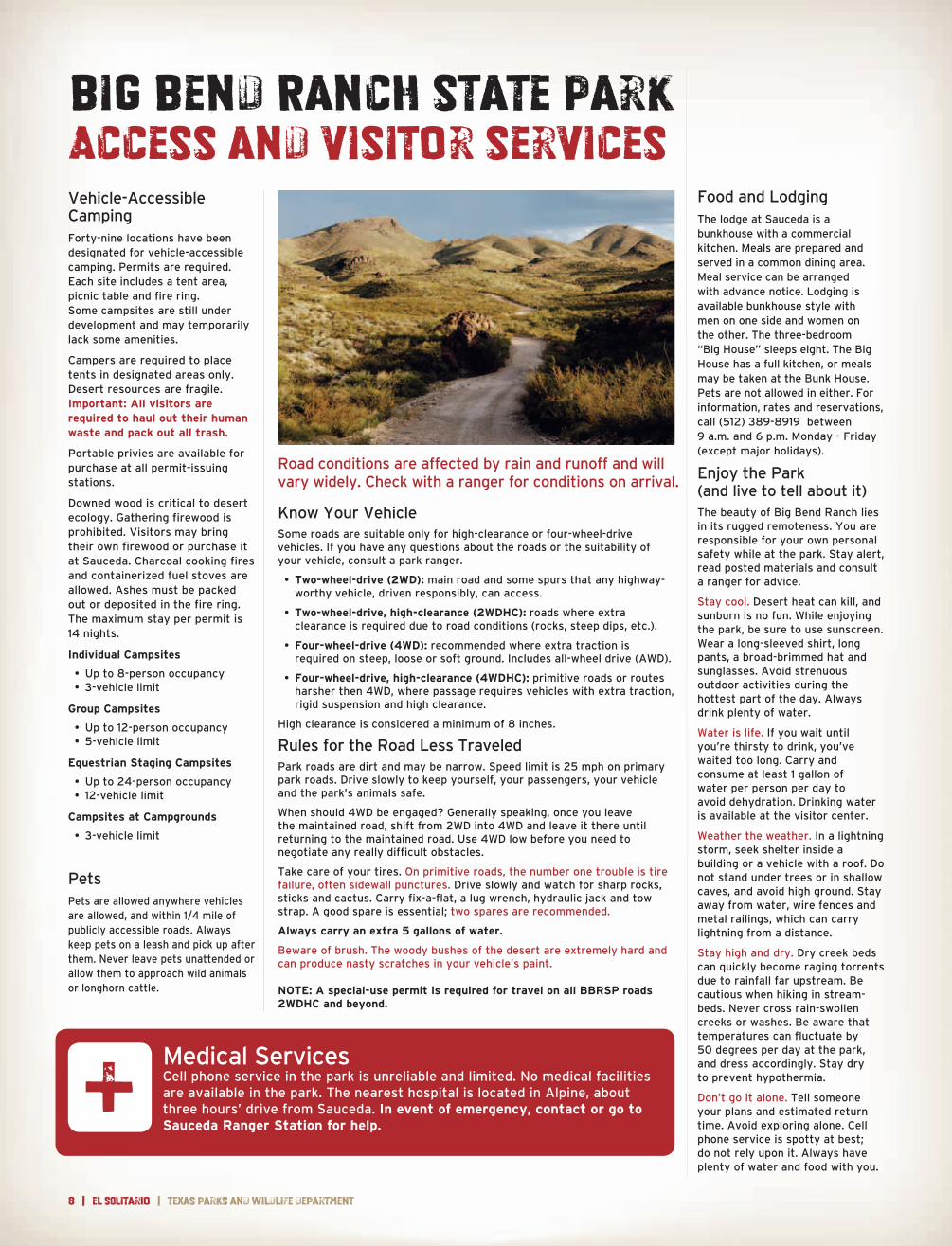
Vehicle TouringThe main entrance road into the interior of BBRSP takes you through the west entrance, “Portal del Presidio,” and on to Sauceda Ranger Station. The Sauceda Road is a well-maintained dirt and gravel thoroughfare that requires slow speeds and is suitable for 2WD vehicles. It is not recommended for large RVs or trailers. From FM 170 it is about 25 miles to Sauceda Ranger Station through world class scenery that you won’t forget.
Various side roads within the park require high-clearance and/or four-wheel drive vehicles. Park staff can advise you where to travel, depending on your type of vehicle and interests. For visitors wanting a serious four-wheel-drive adventure, the booklet entitled “Roads to Nowhere: A Guide to unmain-tained 4X4 high-clearance roads in Big Bend Ranch State Park” is for you. This publication describes several 4X4 routes that traverse the park’s numerous ranch and mining roads.
HikingSeveral short hikes are accessible from the Sauceda Road. The Ojito Adentro trail offers a moderate 1.4-mile round trip that traverses Chihuahuan Desert scrub into moist riparian woodland. Cottonwood and velvet ash trees await you here, with a dripping pour-off, pools of clear water and a hanging garden of maidenhair fern at the head of the canyon. This oasis-like area is prime habitat for a variety of birds, butterflies, dragonflies and other wildlife, and has welcomed many generations of people.
The Cinco Tinajas Trail offers a 0.9-mile round-trip option that is also accessible from the Sauceda Road. The trail provides views into a deep canyon containing a series of tinajas, which are naturally-formed or scoured rock pools that hold water even when many other sources are dry.
Longer hikes and backpacking opportunities abound. Consult park staff for recommendations that will suit your ability and needs.
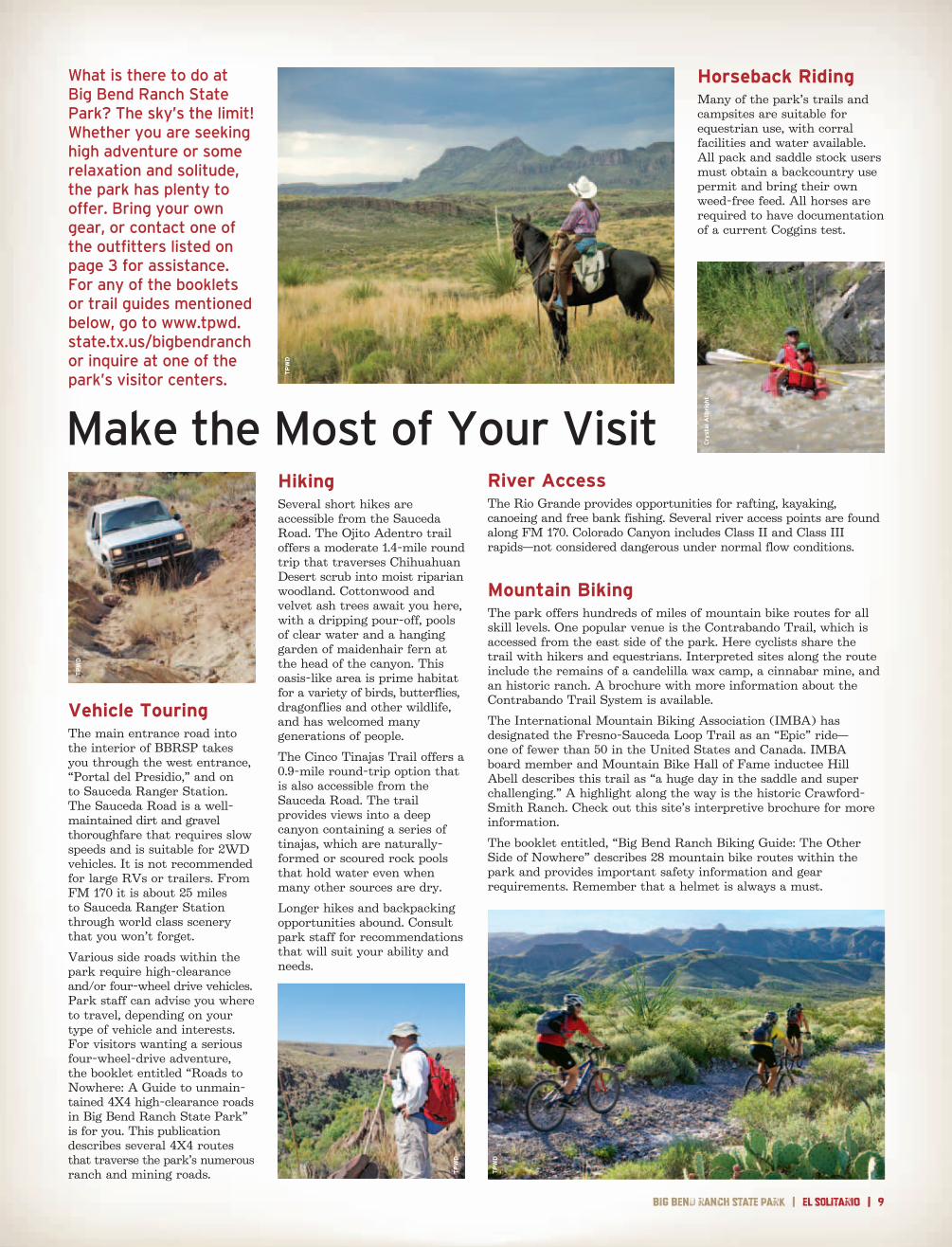
What is there to do at Big Bend Ranch State Park? The sky’s the limit! Whether you are seeking high adventure or some relaxation and solitude, the park has plenty to offer . Bring your own gear, or contact one of the outfitters listed on page 3 for assistance . For any of the booklets or trail guides mentioned below, go to www .tpwd .state .tx .us/bigbendranch or inquire at one of the park’s visitor centers .
Horseback RidingMany of the park’s trails and campsites are suitable for equestrian use, with corral facilities and water available. All pack and saddle stock users must obtain a backcountry use permit and bring their own weed-free feed. All horses are required to have documentation of a current Coggins test.
River AccessThe Rio Grande provides opportunities for rafting, kayaking, canoeing and free bank fishing. Several river access points are found along FM 170. Colorado Canyon includes Class II and Class III rapids—not considered dangerous under normal flow conditions.
TP
WD
TP
WD
TP
WD
Cry
stal
Allb
righ
t
TP
WD
Mountain BikingThe park offers hundreds of miles of mountain bike routes for all skill levels. One popular venue is the Contrabando Trail, which is accessed from the east side of the park. Here cyclists share the trail with hikers and equestrians. Interpreted sites along the route include the remains of a candelilla wax camp, a cinnabar mine, and an historic ranch. A brochure with more information about the Contrabando Trail System is available.
The International Mountain Biking Association (IMBA) has designated the Fresno-Sauceda Loop Trail as an “Epic” ride— one of fewer than 50 in the United States and Canada. IMBA board member and Mountain Bike Hall of Fame inductee Hill Abell describes this trail as “a huge day in the saddle and super challenging.” A highlight along the way is the historic Crawford-Smith Ranch. Check out this site’s interpretive brochure for more information.
The booklet entitled, “Big Bend Ranch Biking Guide: The Other Side of Nowhere” describes 28 mountain bike routes within the park and provides important safety information and gear requirements. Remember that a helmet is always a must.
10 | el SOLitarIo | Texas parks and wildlife department
Desert bighorn sheep (Ovis canadensis mexicana) were extirpated from the state by the early 1960s, when historical unregulated hunting, domestic livestock diseases and habitat loss led to the animal’s demise. But today the future looks considerably brighter. Over the years, animals were reintroduced into west Texas mountain ranges from host populations in several southwestern states and northern Mexico. In late December of 2010, dozens of animals were captured from a thriving herd at Elephant
Mountain Wildlife Management Area and released into the Bofecillos Mountains of Big Bend Ranch State Park. This release— the first and only on state park property in Texas—included 12 rams and 34 ewes, many of them pregnant. Radio collars were affixed to 35 of the animals before their release so their location and activities could be monitored.
Since 1954 an international coalition has endeavored to restore this magnificent, desert mammal. Consisting of federal, state and private conservation entities the consortium conducted extensive studies and supported scientific research in the United States and Mexico. It has taken research in epidemiology as well as ecosystem studies and habitat analysis to understand the animal’s specific threats and needs. The financial demand of these studies was primarily met by private conservation groups and sportsmen who pay taxes on the purchase of firearms and ammunition.
Specific evolutionary adaptations make desert bighorn sheep ideally suited for the environment at Big Bend Ranch State Park. A stocky build allows them to conserve energy during cold nights of the desert winter, and an individual’s body temperature can fluctuate several degrees daily to adapt to changing weather conditions. When the desert heat really bears down, the animal seeks shade in rock overhangs, caves and under the few trees it can find. Padded hooves allow the animal to climb efficiently in the steep, rocky terrain. Keen eyesight allows the desert bighorn to spot mountain lions, coyotes and other predators;
it can attain speeds of 15 miles per hour when chased.
The desert bighorn originally came from a much drier environment than the Bofecillos. Even in the midst of harsh drought these animals can go for days without visiting a water hole, getting moisture from food sources such as leaves, twigs, yucca, cacti and grasses. An individual can lose as much as 30 percent of its body weight to dehydration and then rapidly rehydrate when it finds water. To enhance survival, water guzzlers have been placed at strategic locations around the release site to provide extra water sources for the new arrivals. Guzzlers are composed of an inverted roof that allows rainwater to trickle down into a storage tank. It doesn’t take much water to help the desert bighorn survive.
For most of the year rams and ewes stay in small, gender-specific groups and forage with no concern for the opposite sex. All of that changes during the mating season, when rams challenge one another for access to females. During late summer and early fall, rams gather up a herd of 10 to 12 ewes and fight for mating rights. A ram of about 7 years of age is typically large and strong enough to compete. From distances of about 10 feet, rams run full-tilt into each other, colliding at full speed with their horns. After each collision they stand looking slightly dazed before repeating the collision. At some point one of the rams will walk away from the battle while the other remains with the ewes. The anatomy of the desert big horn is designed to survive these head bashings with
a double-layered skull richly supplied with bone struts in between. This configuration provides a cushion to absorb blows. The spine and skull are attached with thick tendons that help the neck recoil from impact.
Lambing season typically occurs from late winter through early spring. Following a gestation period of about 175 days, a ewe typically gives birth to one lamb (although twinning is possible). This is the time when the desert bighorn are most vulnerable. Ewes try to find a steep, isolated area in which to give birth and care for their lambs. Eagles, bobcats, and coyotes, if they can reach the birthing site, will prey on the newborns, but after as little as a week the lambs can follow their mother almost anywhere with ease. After just a few weeks the lambs form their own groups and return to the ewes only for nourishment. After four to six months the lambs are completely weaned.
Bighorns are technically considered grazers—animals that consume grasses. However, about 50 percent of their diet is actually comprised of browse species—leafy shrubs and forbs. Mostly diurnal, these ruminants typically feed during daylight hours, frequently resting and regurgitating their meals for complete digestion.
It is hard to know what is in store for the newest herd of desert bighorn sheep in Texas. Although a few animals have been lost to predators and natural causes, the herd is generally doing quite well. Be on the lookout for these grand creatures during your stay at Big Bend Ranch State Park, particularly near Santana Mesa on F.M. 170. If you are lucky enough to see one, remember—you have witnessed the return of a native.
This collaborative reintroduction project was a joint effort between TPWD’s Wildlife and State Parks divisions. It would not have been possible without the work of the Texas Bighorn Society, Sul Ross State University, and many others.
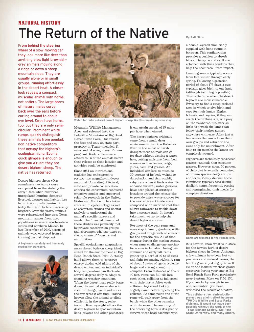
Watch for radio-collared desert bighorn sheep like this ram during your stay.
A bighorn is carefully and humanely readied for transport.
From behind the steering wheel of a slow-moving car they look more like deer than anything else: light brownish-grey animals moving along a ridge or down a steep mountain slope . They are usually alone or in small groups, running effortlessly in the desert heat . A closer look reveals a compact, muscular animal with horns, not antlers . The large horns of mature males curve back over the ears before curling around to about eye level . Ewes have horns, too, but they are only semi-circular . Prominent white rumps quickly distinguish these animals from aoudad: non-native competitors that occupy the bighorn’s ecological niche . Even a quick glimpse is enough to give you a rush: they are desert bighorn sheep . The native has returned .
NATURAL HISTORY
The Return of the Native By Patt Sims
Rams are trailered to the release site.
TP
WD
TP
WD
TP
WD
big bend ranch state park | el SOLitarIo | 11
By Stephanie Loden
Perched overlooking the Rio Grande Valley in southern Presidio County, Fort Leaton State Historic Site stands as a relic of the Chihuahua Trail. Although not intended as a military fortification, the adobe structure acted as an outpost for trade and a source of protection against the Apache on the 450-mile stretch between Fort Duncan in Eagle Pass and Fort Quitman near El Paso. The border established by the treaty that ended the Mexican-American War opened up land and business prospects for opportunists such as Ben Leaton in the mid-1800s.
Maintained by the Texas Parks and Wildlife Department since 1967, Fort Leaton State Historic Site serves as the western gateway into Big Bend Ranch State Park. The curatorial team of TPWD’s Interpretive Services Branch recently completed a two-year project designed to bring new life to the already fascinating story of the fort.
Established around 1848, Fort Leaton historically filled several different roles, from fortified trading post to communal residence. In the 1850s the fort served as an encampment for the U.S. Army during Fort Davis’s construction. The completion of Fort Davis provided a buffer between raiding Apache groups and the lucrative trade convoys travelling through the area. Both Union and Confederate troops grappled for control of the border area during the Civil War, and following the conflict, Fort Leaton remained an important checkpoint for military patrols along the river until about 1880.
Throughout its history, Fort Leaton housed many interesting
and unscrupulous characters. In order to gain control of the land for a trading post, Ben Leaton bribed local government officials to falsify paperwork giving him title to the property. Leaton then proceeded to evict Mexican families already working the land. Though they never married, Juana Pedrasa retained possession of Fort Leaton and the surrounding property after Leaton’s death in 1851. Pedrasa then married Edward Hall, who was a Leaton-employed teamster.
Although they sold Fort Leaton in 1854, the Halls returned from San Antonio several years later to reopen the trading post. Needing extra funding, Hall obtained a cash loan from John Burgess, illegally using Fort Leaton as collateral, despite the fact that he had sold the property years earlier. By December 1862, Hall had defaulted on the loan, opening the way for Burgess to claim the land. The Halls refused to leave the property and continued living and doing business at the fort until 1873.
Of course, any site along the frontier would not be complete without a murder or two. Ten years after Hall defaulted on his loan, John Burgess sent a group of men, including one of his sons, to evict Hall from the property. In the ensuing struggle, Hall was shot and died. Burgess and his cohorts were eventually arraigned and subsequently acquitted of the crime. Ironically, after the acquittals, the Burgess family moved into the fort, even after they themselves lost the property to foreclosure.
In retaliation for his stepfather’s murder, William Leaton, youngest son of Juana Pedrasa-Hall, shot
and killed John Burgess. Leaton was tried and convicted of man-slaughter, but ultimately received a pardon from prison due to poor health. Soon after, William was shot and killed by the chief of police of Presidio del Norte.
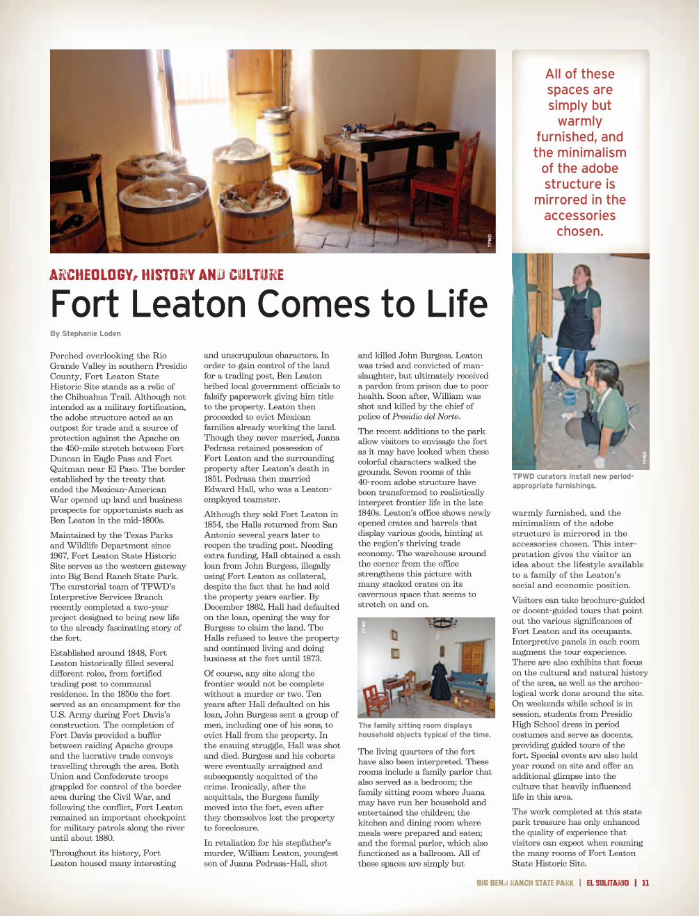
The recent additions to the park allow visitors to envisage the fort as it may have looked when these colorful characters walked the grounds. Seven rooms of this 40-room adobe structure have been transformed to realistically interpret frontier life in the late 1840s. Leaton’s office shows newly opened crates and barrels that display various goods, hinting at the region’s thriving trade economy. The warehouse around the corner from the office strengthens this picture with many stacked crates on its cavernous space that seems to stretch on and on.
The living quarters of the fort have also been interpreted. These rooms include a family parlor that also served as a bedroom; the family sitting room where Juana may have run her household and entertained the children; the kitchen and dining room where meals were prepared and eaten; and the formal parlor, which also functioned as a ballroom. All of these spaces are simply but
warmly furnished, and the minimalism of the adobe structure is mirrored in the accessories chosen. This inter-pretation gives the visitor an idea about the lifestyle available to a family of the Leaton’s social and economic position.
Visitors can take brochure-guided or docent-guided tours that point out the various significances of Fort Leaton and its occupants. Interpretive panels in each room augment the tour experience. There are also exhibits that focus on the cultural and natural history of the area, as well as the archeo-logical work done around the site. On weekends while school is in session, students from Presidio High School dress in period costumes and serve as docents, providing guided tours of the fort. Special events are also held year round on site and offer an additional glimpse into the culture that heavily influenced life in this area.
The work completed at this state park treasure has only enhanced the quality of experience that visitors can expect when roaming the many rooms of Fort Leaton State Historic Site.
TPWD curators install new period-appropriate furnishings.
The family sitting room displays household objects typical of the time.
Archeology, History and Culture
Fort Leaton Comes to Life
All of these spaces are simply but
warmly furnished, and the minimalism
of the adobe structure is
mirrored in the accessories
chosen .
TP
WD
TP
WD
TP
WD
12 | el SOLitarIo | Texas parks and wildlife department
EXECUTIVE DIRECTOR
Carter P . Smith
T. Dan Friedkin, Chairman
houston
Ralph H. Duggins, Vice-Chairman
fort Worth
Antonio Falcon, M.D. rio grande city
Karen J. Hixon san antonio
Dan Allen Hughes, Jr. Beeville
Bill Jones austin
Margaret Martin Boerne
S. Reed Morian houston
Dick Scott Wimberley
Lee M. Bass, Chairman-Emeritus
fort Worth
TEXAS PARKS AND WILDLIFE DEPARTMENT MISSION STATEMENTTo manage and conserve the natural and cultural resources of Texas and to provide hunting, fishing and outdoor recreation opportunities for the use and enjoyment of present and future generations.
You may view this and other publications through the TPWd Web site. Please visit http://www.tpwd.state.tx.us/publications/.
in accordance with Texas state depository law, this publication is available at the Texas state Publications clearinghouse and/or Texas depository libraries.
TPWD receives federal assistance from the U.S. Fish and Wildlife Service and other federal agencies and is subject to Title VI of the Civil Rights Act of 1964, Section 504 of the Rehabilitation Act of 1973, Title II of the Americans with Disabilities Act of 1990, the Age Discrimination Act of 1975, Title IX of the Education Amendments of 1972, and state anti-discrimi-nation laws which prohibit discrimination the basis of race, color, national origin, age, sex or disability. If you believe that you have been discriminated against in any TPWD program, activity or facility, or need more information, please contact Civil Rights Coordinator for Public Access, U.S. Fish and Wildlife Service, 4401 N. Fairfax Drive, Mail Stop: MBSP-4020, Arlington, VA 22203.
© 2011 Texas Parks and Wildlife department PWd Br P4507-1437 (12/11)
Editorlinda hedges
Editor-EmeritusW. Phil hewitt
Regional Directordeirdre e. hisler
General Superintendent
rod Trevizo
el SOLitarIo
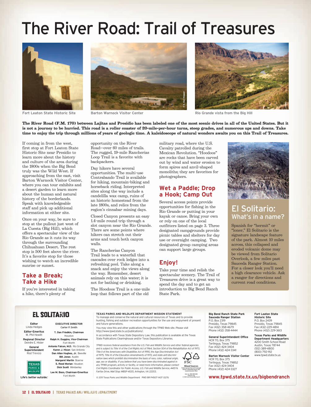
If coming in from the west, first stop at Fort Leaton State Historic Site near Presidio to learn more about the history and culture of the area during the 1800s when the Big Bend truly was the Wild West. If approaching from the east, visit Barton Warnock Visitor Center, where you can tour exhibits and a desert garden to learn more about the human and natural history of the borderlands. Speak with knowledgeable staff and pick up additional information at either site.
Once on your way, be sure to stop at the pullout just west of La Cuesta (Big Hill), which offers a spectacular view of the Rio Grande as it cuts its way through the surrounding Chihuahuan Desert. The rest stop is 500 feet above the river. It’s a favorite stop for those wishing to watch an incredible sunrise or sunset.
Take a Break; Take a HikeIf you’re interested in taking a hike, there’s plenty of
opportunity on the River Road—over 60 miles of trails. The rugged, 19-mile Rancherias Loop Trail is a favorite with backpackers.
Day hikers have several opportunities. The multi-use Contrabando Trail is available for hiking, mountain-biking and horseback riding. Interpreted sites along the way include a candelilla wax camp, ruins of an historic homestead from the late 1800s, and relics from the region’s cinnabar mining days.
Closed Canyon presents an easy 1.4-mile round trip through a slot canyon near the Rio Grande. There are some points where hikers can stretch out their arms and touch both canyon walls.
The Rancherias Canyon Trail leads to a waterfall that cascades over rock ledges into a refreshing pool. Take along a snack and enjoy the views along the way. Remember, desert animals rely on this water; it is not for bathing or drinking.
The Hoodoos Trail is a one-mile loop that follows part of the old
military road, where the U.S. Cavalry patrolled during the Mexican Revolution. “Hoodoos” are rocks that have been carved out by wind and water erosion to form spires and anvil-shaped monoliths; they are favorites for photographers.
Wet a Paddle; Drop a Hook; Camp OutSeveral access points provide opportunities for fishing in the Rio Grande or putting in your kayak or canoe. Bring your own or rely on one of the local outfitters listed on page 3. Three designated campgrounds provide picnic tables and shelters for day use or overnight camping. Two designated group camping areas can support large groups.
Enjoy!Take your time and relish the spectacular scenery. The Trail of Treasures drive is a great way to spend the day and to get an introduction to Big Bend Ranch State Park.
Big Bend Ranch State Park Sauceda Ranger StationP.O. Box 2319Presidio, Texas 79845fax (432) 358-4679Phone (432) 358-4444
General Superintendent Officehcr 70, Box 375Terlingua, Texas 79852fax (432) 424-3404Phone (432) 424-3341
Barton Warnock Visitor Centerhcr 70, Box 375Terlingua, Texas 79852fax (432) 424-3404Phone (432) 424-3327
Fort Leaton State Historic SiteP.O. Box 2439Presidio, Texas 79845fax (432) 229-4814Phone (432) 229-3613
Texas Parks and WildlifeDepartment Headquarters4200 smith school roadaustin, Texas 78744(512) 389-4800(800) 792-1112www.tpwd.state.tx.us
El Solitario: What’s in a name?Spanish for “hermit” or “loner,” El Solitario is the signature landscape feature of the park. Almost 10 miles across, this collapsed and eroded volcanic dome may be viewed from Solitario Overlook, a few miles past Sauceda Ranger Station. For a closer look you’ll need a high clearance vehicle. Ask a ranger for directions and current road conditions.
XX%
Cert no. XXX-XXX-000
www.tpwd.state.tx.us/bigbendranch
The River Road: Trail of Treasures
Barton Warnock Visitor CenterFort Leaton State Historic Site Rio Grande vista from the Big Hill
© E
. Dan
Kle
pper
TP
WD
TP
WD
The River Road (F.M. 170) between Lajitas and Presidio has been labeled one of the most scenic drives in all of the United States. But it is not a journey to be hurried. This road is a roller coaster of 20-mile-per-hour turns, steep grades, and numerous ups and downs. Take time to enjoy the trip through millions of years of geologic time. A kaleidoscope of natural wonders awaits you on this Trail of Treasures.