Benthic Ecology Characterisation...
112
NEART NA GAOITHE PROPOSED OFFSHORE WIND FARM Benthic Ecology Characterisation Survey FINAL REPORT A Report for: Neart na Gaoithe Offshore Wind Ltd. The copyright and intellectual property rights in this document are the property of Emu Limited. The said intellectual property rights shall not be used, nor shall this document be copied without the express consent of Emu Limited Report No : 09/J/1/03/1483/0943 Issue date : June 2010 Emu contact : Mr Paul English Job No.: J/1/03/1483 Tel : 01489 860050 also at Emu Limited Marine Laboratories Ferry Road Hayling Island Hampshire PO11 0DG UK Tel: +44 (0)23 9263 6800 Fax: +44 (0)23 9263 7215 www.emulimited.com Emu Limited Oceanography Unit 7 Hayling Billy Industrial Estate Hayling Island Hampshire PO11 0ED UK Tel: +44 (0)23 9231 1130 Fax: +44 (0)23 9263 7759 www.emulimited.com Emu Limited Head Office 1 Mill Court The Sawmills Durley Southampton SO32 2EJ UK Tel: +44 (0)1489 860050 Fax: +44 (0)1489 860051 www.emulimited.com
Transcript of Benthic Ecology Characterisation...
NEART NA GAOITHE
PROPOSED OFFSHORE WIND FARM
Benthic Ecology Characterisation Survey
FINAL REPORT
A Report for:
Neart na Gaoithe Offshore Wind Ltd.
The copyright and intellectual property rights in this document are the property of Emu Limited. The said intellectual property rights shall not be used, nor shall this document be copied without the express consent of Emu Limited
Report No : 09/J/1/03/1483/0943
Issue date : June 2010
Emu contact : Mr Paul English
Job No.: J/1/03/1483
Tel : 01489 860050
also at
Emu Limited Marine Laboratories Ferry Road Hayling Island Hampshire PO11 0DG UK Tel: +44 (0)23 9263 6800 Fax: +44 (0)23 9263 7215 www.emulimited.com
Emu Limited Oceanography Unit 7 Hayling Billy Industrial Estate Hayling Island Hampshire PO11 0ED UK Tel: +44 (0)23 9231 1130 Fax: +44 (0)23 9263 7759 www.emulimited.com
Emu Limited Head Office 1 Mill Court The Sawmills Durley Southampton SO32 2EJ UK Tel: +44 (0)1489 860050 Fax: +44 (0)1489 860051 www.emulimited.com

Neart na Gaoithe Offshore Wind Ltd. Neart na Gaoithe Proposed Offshore Wind Farm Benthic Ecology Characterisation Survey
09/J/1/03/1483/0943/PAE/Jun 2010 Emu Ltd.
i
Document Release and Authorisation Record
Job No: Report No: Date: Client Name: Client Contact(s):
J/1/03/1483 09/J/1/03/1483/0943 June 2010 Neart na Gaoithe Offshore Wind Ltd Cameron Smith Zoe Crutchfield
Version: 1
Status: Final
QA Name Initial Date
Project Manager
Dr N.S. Thomas
Report written by Paul English
Erin Pettifer
Data analysed by Paul English
Report checked by Dr N.S. Thomas
Report authorised by Dr N.S. Thomas
Neart na Gaoithe Offshore Wind Ltd. Neart na Gaoithe Proposed Offshore Wind Farm Benthic Ecology Characterisation Survey
09/J/1/03/1483/0943/PAE/Jun 2010 Emu Ltd.
ii
Neart na Gaoithe Offshore Wind Ltd. Neart na Gaoithe Proposed Offshore Wind Farm Benthic Ecology Characterisation Survey
09/J/1/03/1483/0943/PAE/Jun 2010 Emu Ltd.
iii
Table of Contents
Page No 1.0 INTRODUCTION ......................................................................................................................................... 1 Background to the study .................................................................................................................................. 1 The regional benthic context ........................................................................................................................... 2 2009 geophysical study .................................................................................................................................... 4 2.0 METHODS .................................................................................................................................................. 6 Intertidal biotope mapping survey .................................................................................................................. 6 Intertidal biotope map production .................................................................................................................. 8 Subtidal survey ................................................................................................................................................. 8 Site positioning and sampling ........................................................................................................................ 11 Benthic laboratory processing ....................................................................................................................... 12 Data Analysis .................................................................................................................................................. 13 3.0 INTERTIDAL SURVEY RESULTS ................................................................................................................. 15 Cockenzie biotope results .............................................................................................................................. 15 Biotope distribution at Cockenzie ................................................................................................................. 28 Thorntonloch biotope results ........................................................................................................................ 29 Biotope distribution at Thorntonloch ............................................................................................................ 43 Skateraw biotope results ............................................................................................................................... 45 Biotope distribution at Skateraw ................................................................................................................... 70 4.0 SUBTIDAL SURVEY RESULTS .................................................................................................................... 72 Sediment particle size distribution data (PSD) .............................................................................................. 72 Macrofaunal grab sample data ...................................................................................................................... 81 Seabed image data ......................................................................................................................................... 90 2 m beam trawl data ...................................................................................................................................... 95 Biotope map of the proposed turbine array ................................................................................................. 98 Seabed contaminants .................................................................................................................................... 99 4.0 DISCUSSION .......................................................................................................................................... 100 Seabed benthic environment ...................................................................................................................... 100 Intertidal environment ................................................................................................................................. 101 5.0 CONCLUSIONS ....................................................................................................................................... 103 6.0 REFERENCES .......................................................................................................................................... 104 APPENDICES (on CD)

Neart na Gaoithe Offshore Wind Ltd. Neart na Gaoithe Proposed Offshore Wind Farm Benthic Ecology Characterisation Survey
09/J/1/03/1483/0943/PAE/Jun 2010 Emu Ltd.
iv
Neart na Gaoithe Offshore Wind Ltd. Neart na Gaoithe Proposed Offshore Wind Farm Benthic Ecology Characterisation Survey
09/J/1/03/1483/0943/PAE/Jun 2010 Emu Ltd.
1
1 Introduction
Background to the Study 1.1 Neart na Gaoithe Offshore Wind Limited (NnGOWL) has been awarded exclusive rights for the
development of the Neart na Gaoithe offshore wind farm.
1.2 The proposed development will be located within the outer Forth Estuary some 15.5 km east of Fife Ness and 30 km north of Torness and will cover 105 km
2. It is likely to consist of 75 turbines, each
having a capacity of 6 MW, giving a total installed capacity of 450 MW.
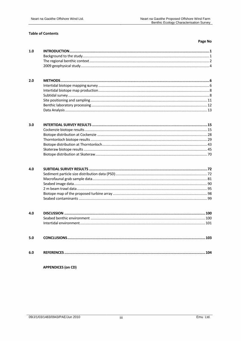
1.3 Associated cable route options include a 54 km to the south west making landfall at Cockenzie further up the Forth Estuary, and the Torness Cable route, which incorporates two choices for connections at either Skateraw or Thorntonloch, and runs more or less south of the site for 32 km. Figure 1.1 shows the location of the proposed offshore wind farm site and cable possible routes.
Figure 1.1: Location of the proposed Neart na Gaoithe offshore wind farm development site and cable route options.
1.4 Details regarding the need for the development together with the site selection process have been
presented within the scoping report which may be found at http://www.neartnagaoithe.com/. 1.5 This proposed development is now undergoing rigorous environmental and technical assessment prior
to making any application for consent. The final consent application requires a supporting Environmental Impact Assessment (EIA) presenting, amongst other issues, detailed appraisals of the potential effects of the construction and operation of the development on benthic habitats and species within the turbine array, along the cable route options and at the different cable landfall sites currently under consideration.
1.6 Emu Ltd was commissioned to undertake a series of benthic ecology sampling surveys of the turbine
array site, the cable route options and associated intertidal areas where the cables are proposed to make landfall for the purposes of collecting physical, chemical and biological data suitable for informing
Neart na Gaoithe Offshore Wind Ltd. Neart na Gaoithe Proposed Offshore Wind Farm Benthic Ecology Characterisation Survey
09/J/1/03/1483/0943/PAE/Jun 2010 Emu Ltd.
2
an EIA and development of an Environmental Statement. This document presents the survey methods used, the data collected and gives a characterisation of the intertidal and subtidal environment within and around the proposed development in terms of the habitats available and associated biological communities.
1.7 The data derived from these surveys will be used to underpin the EIA with respect to predicted effects
of the construction and operation of the Neart na Gaoithe offshore wind farm on the local seabed ecology. In particular, the data will highlight potential ecological sensitivities and assist in the development of mitigation measures where appropriate.
The Regional Benthic Context 1.8 The proposed Neart na Gaoithe development site lies within Glémarec’s ‘étage coutier’, referring to a
distinct benthic ecological division within the central North Sea (Glémarec, 1973). This division is located between the northern flank of the Dogger Bank and the 100 m contour of the northern North Sea and is closely related to a set of specific abiotic variables such as depth, broad sediment types and thermal stability at the seabed. In general, the waters lie between those of the open sea and the coast and they can be constantly mixed or they may present a thermocline. Annual temperature variations are usually of the order of 7
0C to 8
0C with a maximum of 16
0C. Typical sediment habitats and
associated species include mud with sea pens Virgularia mirabilis and polychaetes Lagis sp. together with muddy sands with infaunal brittlestars Amphiura filiformis and the gastropod Turritella communis.
1.9 Benthic data drawn from the Mapping European Seabed Habitats (MESH) project, a pan-European
collaboration which plans to classify and map seabed habitats across the north east Atlantic area, are presented in Figure 1.2. This shows that the proposed turbine site will coincide with a very small portion of the widely distributed and commonly occurring ‘deep circalittoral sand’ habitat which typifies the wider region. MESH data present predicted broad-scale seabed habitats based on known physical conditions.
1.10 The cables will also coincide with the ‘deep circalittoral mud’ habitat indicated as characteristic of
the outer Forth Estuary and widely distributed in this area. Further up the estuary, the habitats become more mixed and are classified as ‘circalittoral sandy mud’ and ‘circalittoral fine mud’ together with its shallower water (infralittoral) counterpart close to the proposed landfall site at Cockenzie. The more southerly cable route option corresponds to deep ‘circalittoral coarse sediment’ and ‘low energy rock’ habitats toward the southerly extents of both the Skateraw and Torness options. Again, all predicted MESH habitats along the cable route options appear to be common throughout the wider region indicating that there will be no significant effect on habitat diversity at the regional level as a result of the construction of the wind farm.
1.11 Tidal current speeds within the Forth Estuary are regarded as generally low (typically less than 0.5 m/s)
(Eleftheriou et al., 2004). The flood tide currents are stronger on the north side of the Firth whilst stronger ebb tides occur on the southern shore. Consequently, there is a drift towards the west in the northern and central estuary, with an eastward flow along the southern shore.
1.12 Broad-scale trawling surveys throughout the North Sea (Calloway et al., 2002) have identified
characteristic fish and epibenthic assemblages associated with the general region of the current proposals. Typical fish species found included haddock, Melanogrammus aeglefinus, whiting Merlangius merlangus, dab Limanda limanda, plaice Pleuronectes platessa, herring Clupea harengus and grey gurnard Eutrigla gurnardus. Other components of the epibenthos were more characteristic of the shallower sediments of the southern North Sea and included the shrimps Crangon crangon, C. allmani and Philoceras trispinosus, the crab Corystes cassivelaunus and the starfish Asteropecten irregularis.

Neart na Gaoithe Offshore Wind Ltd. Neart na Gaoithe Proposed Offshore Wind Farm Benthic Ecology Characterisation Survey
09/J/1/03/1483/0943/PAE/Jun 2010 Emu Ltd.
3
Figure 1.2: Predicted MESH habitats for the wider Forth Estuary region (www.jncc.co.uk, 2009)
1.13 Jennings et al. (1999) also completed a number of trawl samples in the wider area of the proposals at
Neart na Gaoithe and found a range of characteristic colonial sessile epibenthic species includeing the erect bryozoan Flustra foliacea, the hydroid Hydrallmania falcata, and the soft coral Alcyonium digitatum together with a typical mobile assemblage comprising the common starfish Asterias rubens, the shrimp C. allmani, the hermit crab Pagurus bernhardus and the crab Hyas coarctatus.
1.14 The infaunal communities across the wider area have been previously described during monitoring studies at sewage sludge disposal sites at St Abb’s Head and Bell Rock as reviewed by Eletheriou et al. (2004). These corresponded to a typical Amphiura community characterised by the dominance of polychaetes and possessing a low abundance / high diversity structure typical of unpolluted shelf sediment deposits throughout the north east Atlantic. Conspicuous components of the infauna at Bell Rock included the polychaetes Spiophanes bombyx, Pholoe inornata, Galathowenia oculata and Lumbrineris sp. together with the bivalves Nucula (Nuculoma) tenuis, Mysella bidentata and Abra sp. A similar suite of species was also found at St Abb’s Head together with the polychaetes Prionospio fallax, Levensinia gracilis and Owenia fusiformis with the bivalves M. bidentata and Thyasira, echinoids (sea urchins) and crustacean amphipods such as Harpinia sp.
1.15 A series of intertidal ecological surveys of the Forth Estuary (Posford Haskoning, 2002) have broadly characterised the habitats and associated species along the coasts within the vicinity of the proposed cable route landfall sites at Cockenzie and also at Skateraw and Thorntonloch. These found a range of typical barnacle and fucoid dominated rocky shorelines at Cockenzie supporting channelled wrack Pelvetia caniliculata, bladderwrack Fucus vesiculosus, limpets Patella vulgata, barnacles Chthalamus stellatus, together with grey and yellow lichens Verrucaria sp. and Xanthoria parietina. Shallow rock pools contained the coralline red alga Corallina officinalis The stretch of coastline around Dunbar was characterised as extensive bedrock and boulder shore interspersed with sandy areas. Mid tide rock was dominated by F. vesiculosus or else had little fucoid cover with barnacles and limpets. Lower shore rock supported serrated wrack F. serratus with the red algae Porphyra sp. and Chondrus crispus together with mussels Mytilus edulis which in some places occurred in extensive and dense patches. Deep rocky pools were characterised by kelps and fucoid algae. Extensive areas of sand were either barren or supported polychaetes including the lug worm Arenicola marina in places.
Neart na Gaoithe Offshore Wind Ltd. Neart na Gaoithe Proposed Offshore Wind Farm Benthic Ecology Characterisation Survey
09/J/1/03/1483/0943/PAE/Jun 2010 Emu Ltd.
4
1.16 A second visit to the shore between Car Rocks to Scoughall Rocks by Posford Haskoning (2002) recorded a complex rocky coastline comprising red sandstone extensively sculptured by rock mills and rounded deeper pools overlaying a harder rock running in fractured ridges in a north east direction. Mid and lower eulittoral pools were dominated by the sea oak Halidrys siliquosa and the kelp Laminaria digitata.
1.17 More recently, a survey of coastal and shallow subtidal rocky habitats at the Isle of May Special Area of
Conservation (SAC) (Moore et al., 2009) found 30 rock and mixed sediment biotopes from a series of transect and seabed video surveys. Shallow water stable rocky reef areas generally supported a low diversity community dominated by algal and faunal crust species such as the encrusting bryozoan Parasmittina trispinosa matching the Marine Habitat Classification (Connor et al., 2004) CR.MCR.EcCr.FaAlCr with occasional dense calcareous tube worms Pomatoceros spp. (CR.MCR.EcCr.FaAlCr.Pom) or dense Alcyonium digitatum (CR.MCR.EcCr.FaAlCr.Adig). Areas of elevated rocky substrata and mixed sediments comprising coarse sand with scattered pebbles and cobbles also supported dense carpets of the epifaunal brittlestar Ophiothrix fragilis and also Ophiocomina nigra (CR.MCR.EcCr.FaAlCr.Bri and SS.SMx.CMx.OphMx).
1.18 The sublittoral fringe was dominated by grazed kelp Laminaria hyperborea biotopes (IR.MIR.KR.Lhyp.GzFt
and IR.MIR.KR.Lhyp.GzPk) whilst lower and mid exposed eulittoral shore levels supported mosaics of barnacles and bladderwrack Fucus vesiculosus (LR.MLR.BF.FvesB and LR.HLR.MusB.SemSem) with knotted wrack Ascophyllum nodosum (LR.LLR.F.Asc.FS) dominating sheltered shores. Upper shore levels supported a typical range of species such as grey and yellow lichens Verrucaria maura and Xanthora parietina at the supra-littoral fringe together with upper eulittoral algae such as channelled wrack Pelvetia caniliculata and spiral wrack Fucus spiralis, gut weed Enteromorpha intestinalis and the green alga Cladophora sp. Typical fauna included limpets Patella vulgata, blue ray limpet Helcion pellucidum, winkles Littorina obtusata and dog whelk Nucella lapillus and beadlet anemone Actinia equina.
2009 Geophysical survey 1.19 Prior to the benthic sampling at Neart na Gaoithe, a geophysical survey including side scan sonar, AGDS
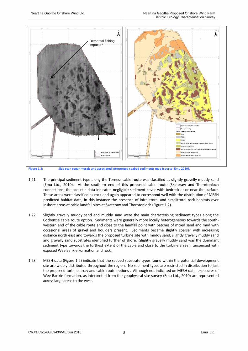
and swath bathymetry was undertaken over the proposed turbine site and local surrounding areas and also along each cable route option to acquire seabed physical data and further inform the proposed development (Emu Ltd., 2010). This identified several different seabed types representing potentially different benthic habitats based on the diverse range of acoustic signatures recorded. Seabed scars, possibly associated with demersal fishing were also noted. Figure 1.3 presents the side scan sonar mosaic indicating the distribution of reflective signatures suggesting the spread of different seabed types together with an interpreted seabed sediments map for the proposed turbine array.
1.20 The principal sediment type within the proposed turbine site was classified as slightly gravelly muddy sand
and dominated western and southern parts of the site where water depths are greater. In the north of the site, the seabed was classified as muddy sand with occasional rock whilst eastern and central areas were interpreted as sand. These classifications accorded with the broad-scale MESH classifications of deep circalittoral sand assigned to this general area (see Figure 1.2). Sand was commonly found where the seabed was flat and smooth in the troughs between mounds of the Wee Bankie formation.
Neart na Gaoithe Offshore Wind Ltd. Neart na Gaoithe Proposed Offshore Wind Farm Benthic Ecology Characterisation Survey
09/J/1/03/1483/0943/PAE/Jun 2010 Emu Ltd.
5
Figure 1.3: Side scan sonar mosaic and associated interpreted seabed sediments map (source: Emu 2010).
1.21 The principal sediment type along the Torness cable route was classified as slightly gravelly muddy sand
(Emu Ltd., 2010). At the southern end of this proposed cable route (Skateraw and Thorntonloch connections) the acoustic data indicated negligible sediment cover with bedrock at or near the surface. These areas were classified as rock and again appeared to correspond well with the distribution of MESH predicted habitat data, in this instance the presence of infralittoral and circalittoral rock habitats over inshore areas at cable landfall sites at Skateraw and Thorntonloch (Figure 1.2).
1.22 Slightly gravelly muddy sand and muddy sand were the main characterising sediment types along the
Cockenzie cable route option. Sediments were generally more locally heterogeneous towards the south-western end of the cable route and close to the landfall point with patches of mixed sand and mud with occasional areas of gravel and boulders present. Sediments became slightly coarser with increasing distance north east and towards the proposed turbine site with muddy sand, slightly gravelly muddy sand and gravelly sand substrates identified further offshore. Slightly gravelly muddy sand was the dominant sediment type towards the furthest extent of the cable and close to the turbine array interspersed with exposed Wee Bankie Formation and rock.
1.23 MESH data (Figure 1.2) indicate that the seabed substrate types found within the potential development
site are widely distributed throughout the region. No sediment types are restricted in distribution to just the proposed turbine array and cable route options . Although not indicated on MESH data, exposures of Wee Bankie formation, as interpreted from the geophysical site survey (Emu Ltd., 2010) are represented across large areas to the west.
Demersal fishing impacts?

Neart na Gaoithe Offshore Wind Ltd. Neart na Gaoithe Proposed Offshore Wind Farm Benthic Ecology Characterisation Survey
09/J/1/03/1483/0943/PAE/Jun 2010 Emu Ltd.
6
2 Methods
2.1 Emu Ltd. undertook the intertidal biotope mapping, subtidal sampling of the benthos and the subsequent laboratory based macro-invertebrate analysis. All methods employed by Emu Ltd conformed with in-house operating procedures and/or ISO9001 control procedures where appropriate and are described below. The sediment particle distribution analysis was undertaken at Emu’s UKAS accredited laboratory.
2.2 Emu are participants in the National Marine Biological Analytical Quality Control scheme (NMBAQC), an independent, national QC scheme designed to assess the quality of marine benthic taxonomy within UK laboratories. Emu have been participants in the scheme since 1996 and have consistently passed the taxonomic components of the scheme.
Intertidal biotope mapping survey 2.3 At each of the three cable route option sites, Cockenzie, Thorntonloch and Skateraw, a broad scale
biotope mapping survey of the intertidal area was conducted. Each survey encompassed the region from the splash/lichen zone (supra-littoral) to the sub-littoral fringe, within an area extending 250 m either side of the proposed cable route landfall.
2.4 The surveys were conducted over low spring tides to allow access to the lowest reaches of the shore and to maximise working time. The entire survey took three days to complete and was carried out between the 21
st and 23
rd of August 2009.
2.5 Base maps derived from aerial photography and ordnance survey were annotated in the field, with total species inventories where possible. Emu Ltd intertidal mapping recording forms were utilised including, the polygon log form, waypoint log form, photo log form and a target note log form. The methodology employed followed the Joint Nature Conservation Committee (JNCC) procedural guidelines for intertidal mapping (Davies et al., 2001). Biotopes were classified on the basis of the Marine Habitat Classificaiton System (Connor et al., 2004).
2.6 The boundaries of each intertidal polygon were located using a Garmin 48 hand held Global Positioning System unit (GPS), accurate to 10 m but often achieving <5 m accuracy. All GPS survey positions were derived in OSGB 36 Datum, with positions recorded in British National Grid format. Polygon boundaries were identified by a change in the dominance or occurrence of conspicuous species or communities in combination with changes in physical characteristics of the habitat.
2.7 For each polygon the following information was noted:
Physical characteristics, such as substrate type and topographic features (sand ripples, areas of standing water etc);
Species present and their SACFOR abundances (Table 2.1); and
Details of specimen samples taken from sites within the polygon.
2.8 Each waypoint marked with the GPS was noted on the waypoint log form along with the following information:
Waypoint number;
A description of what the waypoint represented; and
Any photo numbers associated with each waypoint.
2.9 Digital photographs were taken during the survey in order to illustrate each habitat and the location of polygon boundaries in relation to adjacent polygons. The position of each photograph was determined using the GPS and recorded on the photo log form together with the following information:
Photo number;
Direction of view; and
Date and description of the view. 2.10 The biotope maps were augmented with target notes. These are vital in biotope surveys to record un-
mappable information. This might include features too small (<25 m²) to be accurately portrayed on a map, features on vertical faces, and found under boulders or overhangs. Target notes are also used to

Neart na Gaoithe Offshore Wind Ltd. Neart na Gaoithe Proposed Offshore Wind Farm Benthic Ecology Characterisation Survey
09/J/1/03/1483/0943/PAE/Jun 2010 Emu Ltd.
7
describe human activities, such as outfalls, coastal protection measures and other man made features that are potential habitat modifiers.
2.11 Target notes were recorded on log sheets and included the following information:
Position of target note feature;
Physical description; and
Associated species.
2.12 In addition to the biotope mapping, quantitative sampling was conducted where particulate sediments dominated. Sampling was consistent with the methods provided in the JNCC Procedural Guideline 3-6 (Davies, et al., 2001).
2.13 Samples were taken using a 11.3 cm diameter core and replicated three-five times for faunal samples, with a separate core taken for PSA analysis. A total of four soft sediment areas were sampled at Skateraw using the core technique and five at Thorntonloch. In addition, two exploratory dig over’s (spade dug samples to a depth of approximately 40cm) were conducted at the latter site, one of which did not contain any macrofauna. At Cockenzie the primarily rocky shore within the area surveyed, two sites were sampled using the dig over technique.
2.14 Sample locations were based on the outcome of the biotope mapping phase. Where soft sediment habitats appeared to differ samples were taken for further analysis at Emu’s laboratory. The differences might be changes in the dominance or occurrence of conspicuous species; physical characteristics such as particle size; the degree of water retention; or location on the shore.
Table 2.1: Abundance Scale used for both Littoral and Sublittoral Taxa from 1990 onwards (Hiscock, 1996).
Growth Form Size of individuals/colonies
%cover Crust/Meadow Massive/Turf <1 cm 1-3 cm 3-15 cm >15 cm Density
>80% S S >1/0.001 m2
40-79% A S A S 1-9/0.001 m2
20-39% C A C A S 1-9/0.01 m2
10-19% F C F C A S 1-9/0.1 m2
5-9% O F O F C A 1-9/ m2
1-5% R O R O F C 1-9/10 m2
<1% density R R O F 1-9/100 m2
R O 1-9/1000 m2
R <1/1000 m2
Key: S = Superabundant, A = Abundant, C = Common, F = Frequent, O = Occasional, R = Rare, P = Present (used when the abundance of an organism could not be estimated accurately).
2.15 Field records, biological photographs and the results from laboratory analyses of samples were used to assign biotopes to all polygons identified. Biotope classification was based on the most recent 2004 (v04.05) system for marine biotopes (Connor et al, 2004). Where biotopes did not perfectly match those published, a description of the variation in the biotope has been provided.

Neart na Gaoithe Offshore Wind Ltd. Neart na Gaoithe Proposed Offshore Wind Farm Benthic Ecology Characterisation Survey
09/J/1/03/1483/0943/PAE/Jun 2010 Emu Ltd.
8
Intertidal biotope map production 2.16 The biotopes later assigned were mapped over aerial photographs to allow area wide interpolation of the
data. 2.17 The biotope maps were produced at a scale of 1:750 (Cockenzie and Skateraw) or 1:1,000 (Thorntonloch)
which gives sufficient level of detail to portray the variety and distribution of the characterising biotopes of the site. For presentational purposes the aerial photograph base-mapping layer was replaced by a land outline with nearby structures for the final maps.
2.18 The boundaries of each biotope were digitised and incorporated within an ArcGIS and overlaid onto the
base-mapping layer as a series of polygons. Each polygon (biotope) was attributed with the biotope classification. Target notes were also overlaid onto the base map and assigned biotopes.
Sub-tidal survey 2.19 The grab sampling and seabed image survey array is presented in Figure 2.1. Figure 2.2 shows the
locations of the 2 m scientific beam trawls.
Figure 2.1: Sub-tidal grab sampling and seabed image array.
Neart na Gaoithe Offshore Wind Ltd. Neart na Gaoithe Proposed Offshore Wind Farm Benthic Ecology Characterisation Survey
09/J/1/03/1483/0943/PAE/Jun 2010 Emu Ltd.
9
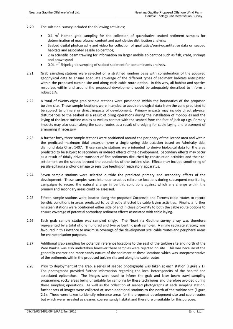
2.20 The sub-tidal survey included the following activities;
0.1 m2 Hamon grab sampling for the collection of quantitative seabed sediment samples for
determination of macrofaunal content and particle size distribution analysis;
Seabed digital photography and video for collection of qualitative/semi-quantitative data on seabed habitats and associated sessile epibenthos;
2 m scientific beam trawling for information on larger mobile epibenthos such as fish, crabs, shrimps and prawns;and
0.04 m2 Shipek grab sampling of seabed sediment for contaminants analysis.
2.21 Grab sampling stations were selected on a stratified random basis with consideration of the acquired geophysical data to ensure adequate coverage of the different types of sediment habitats anticipated within the proposed turbine site and along each cable route option. In this way, all habitat and species resources within and around the proposed development would be adequately described to inform a robust EIA.
2.22 A total of twenty-eight grab sample stations were positioned within the boundaries of the proposed turbine site. These sample locations were intended to acquire biological data from the zone predicted to be subject to primary or direct impacts of development. Primary impacts may include direct physical disturbances to the seabed as a result of piling operations during the installation of monopiles and the laying of the inter-turbine cables as well as contact with the seabed from the feet of jack-up rigs. Primary impacts may also occur along the cable routes as a result of dredging for cable laying and placement of armouring if necessary
2.23 A further forty-three sample stations were positioned around the periphery of the licence area and within the predicted maximum tidal excursion over a single spring tide occasion based on Admiralty tidal diamond data Chart 1407. These sample stations were intended to derive biological data for the area predicted to be subject to secondary or indirect effects of the development. Secondary effects may occur as a result of tidally driven transport of fine sediments disturbed by construction activities and their re-settlement on the seabed beyond the boundaries of the turbine site. Effects may include smothering of sessile epifauna and/or damage to sensitive feeding or respiratory apparatus.
2.24 Seven sample stations were selected outside the predicted primary and secondary effects of the development. These samples were intended to act as reference locations during subsequent monitoring campaigns to record the natural change in benthic conditions against which any change within the primary and secondary areas could be assessed.
2.25 Fifteen sample stations were located along the proposed Cockenzie and Torness cable routes to record benthic conditions in areas predicted to be directly affected by cable laying activities. Finally, a further nineteen stations were positioned either side of and in close proximity to both the cable route options to ensure coverage of potential secondary sediment effects associated with cable laying.
2.26 Each grab sample station was sampled singly. The Neart na Gaoithe survey array was therefore represented by a total of one hundred and twelve benthic grab samples. A single replicate strategy was favoured in this instance to maximise coverage of the development site, cable routes and peripheral areas for characterisation purposes.
2.27 Additional grab sampling for potential reference locations to the east of the turbine site and north of the Wee Bankie was also undertaken however these samples were rejected on site. This was because of the generally coarser and more sandy nature of the sediment at these locations which was unrepresentative of the sediments within the proposed turbine site and along the cable routes.
2.28 Prior to deployment of the grab, a series of seabed photographs was taken at each station (Figure 2.1). The photographs provided further information regarding the local heterogeneity of the habitat and associated epibenthos. The images were used to inform the grab and later beam trawl sampling programme; rocky areas being unsuitable for sampling by these techniques and therefore avoided during these sampling operations. As well as the collection of seabed photographs at each sampling station, further sets of images were collected at seven additional stations to the north of the turbine site (Figure 2.1). These were taken to identify reference areas for the proposed development site and cable routes but which were revealed as cleaner, coarser sandy habitat and therefore unsuitable for this purpose.

Neart na Gaoithe Offshore Wind Ltd. Neart na Gaoithe Proposed Offshore Wind Farm Benthic Ecology Characterisation Survey
09/J/1/03/1483/0943/PAE/Jun 2010 Emu Ltd.
10
2.29 As well as the collection of still images at each station, digital video data were collected via towed video
camera at additional rocky or boulder habitats (exposures of Wee Bankie formation) identified from the interpretation of the acoustic data (Figure 2.1). The video data provided information on species assemblages at rocky and other hard seabed habitat types and which were unsuitable for sampling by grab and trawl techniques. No video data were collected along the short section of cable to the Thorntonloch landfall site because of the presence of dense static fishing gear. However, it is likely that the habitat and species present will be similar to those found along the Skateraw route given the similar seabed sediment types evidenced from the MESH data and recent geophysical survey (Emu Ltd., 2009).
2.30 Selected stations within the proposed turbine array and along the cable route options were further
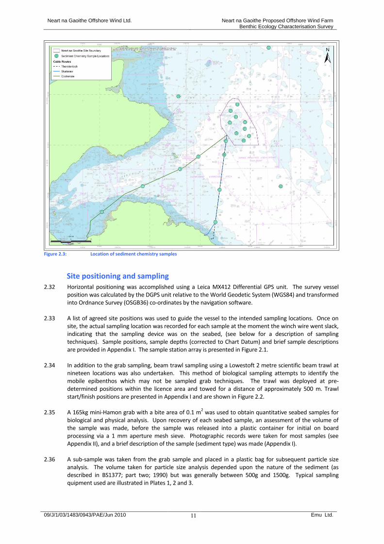
sampled with a Shipek grab for sediment contaminants analysis (Figure 2.3). This was intended to provide further information on the levels of contaminants in sediments that have the potential to be disturbed as a result of direct effects of development and therefore increasing bio-availability. Two samples for contaminants analysis were also collected from reference areas to mitigate for natural fluctuations outside of the influence of the Neart na Gaoithe proposals.
2.31 Finally, a series of 2 m beam trawls were deployed to collect information on assemblages of larger, more
mobile epibenthos such as fish, crabs shrimps and prawns. Trawl sampling locations were selected to provide suitable coverage of the predicted primary and secondary effects of the proposals both within the turbine site and along each cable route. A total of nineteen trawls were collected.
Figure 2.2: Location of 2 m beam trawl samples
Neart na Gaoithe Offshore Wind Ltd. Neart na Gaoithe Proposed Offshore Wind Farm Benthic Ecology Characterisation Survey
09/J/1/03/1483/0943/PAE/Jun 2010 Emu Ltd.
11
Figure 2.3: Location of sediment chemistry samples
Site positioning and sampling 2.32 Horizontal positioning was accomplished using a Leica MX412 Differential GPS unit. The survey vessel
position was calculated by the DGPS unit relative to the World Geodetic System (WGS84) and transformed into Ordnance Survey (OSGB36) co-ordinates by the navigation software.
2.33 A list of agreed site positions was used to guide the vessel to the intended sampling locations. Once on
site, the actual sampling location was recorded for each sample at the moment the winch wire went slack, indicating that the sampling device was on the seabed, (see below for a description of sampling techniques). Sample positions, sample depths (corrected to Chart Datum) and brief sample descriptions are provided in Appendix I. The sample station array is presented in Figure 2.1.
2.34 In addition to the grab sampling, beam trawl sampling using a Lowestoft 2 metre scientific beam trawl at nineteen locations was also undertaken. This method of biological sampling attempts to identify the mobile epibenthos which may not be sampled grab techniques. The trawl was deployed at pre-determined positions within the licence area and towed for a distance of approximately 500 m. Trawl start/finish positions are presented in Appendix I and are shown in Figure 2.2.
2.35 A 165kg mini-Hamon grab with a bite area of 0.1 m
2 was used to obtain quantitative seabed samples for
biological and physical analysis. Upon recovery of each seabed sample, an assessment of the volume of the sample was made, before the sample was released into a plastic container for initial on board processing via a 1 mm aperture mesh sieve. Photographic records were taken for most samples (see Appendix II), and a brief description of the sample (sediment type) was made (Appendix I).
2.36 A sub-sample was taken from the grab sample and placed in a plastic bag for subsequent particle size
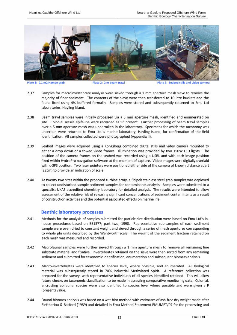
analysis. The volume taken for particle size analysis depended upon the nature of the sediment (as described in BS1377; part two; 1990) but was generally between 500g and 1500g. Typical sampling quipment used are illustrated in Plates 1, 2 and 3.
Neart na Gaoithe Offshore Wind Ltd. Neart na Gaoithe Proposed Offshore Wind Farm Benthic Ecology Characterisation Survey
09/J/1/03/1483/0943/PAE/Jun 2010 Emu Ltd.
12
Plate 1: 0.1 m2 Hamon grab Plate 2: 2 m beam trawl Plate 3: Seabed stills and video camera
2.37 Samples for macroinvertebrate analysis were sieved through a 1 mm aperture mesh sieve to remove the
majority of finer sediment. The contents of the sieve were then transferred to 10 litre buckets and the fauna fixed using 4% buffered formalin. Samples were stored and subsequently returned to Emu Ltd laboratories, Hayling Island.
2.38 Beam trawl samples were initially processed via a 5 mm aperture mesh, identified and enumerated on
site. Colonial sessile epifauna were recorded as ‘P’ present. Further processing of beam trawl samples over a 5 mm aperture mesh was undertaken in the laboratory. Specimens for which the taxonomy was uncertain were returned to Emu Ltd.’s marine laboratory, Hayling Island, for confirmation of the field identification. All samples collected were photographed (Appendix II).
2.39 Seabed images were acquired using a Kongsberg combined digital stills and video camera mounted to
either a drop down or a towed video frames. Illumination was provided by two 150W LED lights. The position of the camera frames on the seabed was recorded using a USBL and with each image position fixed within HydroPro navigation software at the moment of capture. Video images were digitally overlaid with dGPS position. Two laser pointers were positioned either side of the camera of known distance apart (22cm) to provide an indication of scale.
2.40 At twenty two sites within the proposed turbine array, a Shipek stainless steel grab sampler was deployed to collect undisturbed sample sediment samples for contaminants analysis. Samples were submitted to a specialist UKAS accredited chemistry laboratory for detailed analysis. The results were intended to allow assessment of the relative risk of releasing significant concentrations of sediment contaminants as a result of construction activities and the potential associated effects on marine life.
Benthic laboratory processes 2.41 Methods for the analysis of samples submitted for particle size distribution were based on Emu Ltd’s in-
house procedures based on BS1377; part two; 1990. Representative sub-samples of each sediment sample were oven dried to constant weight and sieved through a series of mesh apertures corresponding to whole phi units described by the Wentworth scale. The weight of the sediment fraction retained on each mesh was measured and recorded.
2.42 Macrofaunal samples were further sieved through a 1 mm aperture mesh to remove all remaining fine substrate material and fixative. Invertebrates retained on the sieve were then sorted from any remaining sediment and submitted for taxonomic identification, enumeration and subsequent biomass analysis.
2.43 Macro-invertebrates were identified to species level, where possible, and enumerated. All biological material was subsequently stored in 70% Industrial Methylated Spirit. A reference collection was prepared for the survey, with representative individuals of all species identified retained. This will allow future checks on taxonomic classification to be made in assessing comparative monitoring data. Colonial, encrusting epifaunal species were also identified to species level where possible and were given a P (present) value.
2.44 Faunal biomass analysis was based on a wet-blot method with estimates of ash-free dry weight made after
Eleftheriou & Basford (1989) and detailed in Emu Method Statement EMUMET/07 for the processing and
Neart na Gaoithe Offshore Wind Ltd. Neart na Gaoithe Proposed Offshore Wind Farm Benthic Ecology Characterisation Survey
09/J/1/03/1483/0943/PAE/Jun 2010 Emu Ltd.
13
analysis of macroinvertebrate samples. Faunal samples were separated into infaunal and epifaunal species, the former only being included in the analysis. The retained infauna were then separated into the following phyla:
1. Polychaeta 2. Crustacea 3. Echinodermata 4. Mollusca 5. Others
2.45 The divided fauna were then placed on pre-weighed and labelled sheets of absorbent paper and blot dried before being transferred to a suitable container on a tared balance. The weight of the fauna was then measured to 0.0001g and recorded on the Species Identification Record form. Weighed fauna were then returned to the original vial under IMS and held in storage.
2.46 From these data, estimates of weight in g ash-free dry weight were made using the following conversion factors (Eleftheriou & Basford, 1989):
Polychaeta : 15.5 % Crustacea : 22.5 % Echinodermata : 8.0 % Mollusca : 8.5 % Others : 15.5 %
Data analysis 2.47 The macro-invertebrate community structure and sediment distributions were investigated by employing
a number of univariate and multivariate statistical measures drawn from the Plymouth Marine Laboratories PRIMER v6 (Plymouth Routines In Multivariate Ecological Research) suite of programs (Clarke & Gorley, 2006; Clarke & Warwick, 2001).
2.48 Faunal data were imported into PRIMER, and were subject to transformation. Transformation is most
commonly applied where the fauna is numerically dominated by a few species. Transformation reduces the influence of these more dominant species, with transformations ranging in severity from no transformation to the reduction of all the data to presence/absence only. In the case of the current faunal data, a square root transformation was applied. This transformation serves to down-weight the dominant species, taking a much greater account of the less frequently occurring species, and allowing the underlying community structure to be assessed.
2.49 The transformed data were then subjected to hierarchical clustering. This cluster analysis divides sites into groupings based on a measure of similarity, in this case the Bray-Curtis index, which compares all samples with all other samples, producing a similarity matrix. The cluster analysis gradually combines sites into groups starting with the highest mutual similarities and then gradually lowering the similarity level at which groups are formed. The process ends with a single cluster containing all sites, and is best expressed as a dendrogram diagram, showing the sequential clustering of sites against relative similarity.
2.50 The MDS (Multi-dimensional Scaling) procedure uses the same similarity matrix as that used by the cluster
analysis to produce an ordination of sites which is multi-dimensional. This attempts to satisfy all of the between-sites relationships indicated by the similarity matrix, in terms of the multi-dimensional spatial relationships between sites. This multi-dimensional ordination is then reduced to a 2 dimensional representation that is a more accessible and useable representation. The representativeness of this 2 dimensional version, in comparison to the multi-dimensional array, is indicated by a stress level. The closer this stress level is to zero, the better the fit.
2.51 Sediment data were also imported into PRIMER and normalised and subjected to hierarchical clustering
using Euclidean distance as the similarity measure. In addition, Principal Components Analysis (PCA) Ordination analysis was performed on the sediment data.
Neart na Gaoithe Offshore Wind Ltd. Neart na Gaoithe Proposed Offshore Wind Farm Benthic Ecology Characterisation Survey
09/J/1/03/1483/0943/PAE/Jun 2010 Emu Ltd.
14
2.52 SIMPER (similarity percentages) analysis was also applied to the data to gauge the distinctiveness of each sample cluster, as identified by clustering and MDS.
2.53 BIOENV was used to assess the abiotic environmental variables which best match the observed clustering
of faunal samples following Bray-Curtis and/or MDS. 2.54 The ANOSIM (analysis of similarities) test calculates a test statistic (R) which lies within the range -1 to 1.
This statistic is a reflection of the differences between groups (expressed as the average of all rank similarities) minus the differences within groups. Interpretation of whether there are any differences between groups is usually undertaken by comparing the observed R to the distribution of R values derived from a global test of a series of random permutations of all samples. As a general guide however, values of R close to 0 indicate no differences between the groups whereas large R values suggest evidence of group separation (Clarke & Warwick (2001). Clarke & Gorley (2006) suggest that R-values >0.75 are considered as well separated; R>0.5 as overlapping, but clearly different and R<0.25 as barely separable at all.
2.55 .
2.56

Neart na Gaoithe Offshore Wind Ltd. Neart na Gaoithe Proposed Offshore Wind Farm Benthic Ecology Characterisation Survey
09/J/1/03/1483/0943/PAE/Jun 2010 Emu Ltd.
15
3 Intertidal Survey Results
3.1 In order to assign biotopes to habitats identified within the survey areas, the physical and biological characteristics have been considered based on the Marine Nature Conservation Review (MNCR) field recording techniques (Hiscock et al., 1996).
3.2 A number of the biotopes present were found as a biotope mosaic, whereby more than one biotope is
considered present in a particular area, and there is no discernable boundary between the biotopes considered as part of the mosaic.
3.3 The degree of wave exposure is an important element in determining biotopes. All three possible cable
landfall sites are considered to be between moderately exposed and exposed. 3.4 The following paragraphs detail the biotopes assigned on a site by site basis.
Cockenzie biotope results 3.5 At Cockenzie a total of two sub-biotopes and six biotopes were identified across the survey area. Table
3.1 presents a summary list of the observed biotopes found at Cockenzie. Table 3.1: Summary of observed biotopes along the intertidal within the survey area at Cockenzie
Polygon / Target note
Biotope Code Name
Polygon 1
Upper shore: LS.LSa.MoSa.BarSa & Lower shore: LS.LSa.MoSa.AmSco
Upper shore: Barren littoral coarse sand & Lower shore: Amphipods and Scolelepis spp. in littoral medium-fine sand
Polygon 2 LR.HLR.MusB.Cht.Cht (cobbles & small boulders)
Chthalamus spp. on exposed upper eulittoral rock
Polygon 3 LR.HLR.MusB.Cht.Cht (large boulders)
Chthalamus spp. on exposed upper eulittoral rock
Polygon 4 LS.LBR.LMus.Myt.Mx Mytilus edulis beds on littoral mixed substrata
Polygon 5 IR.MIR.KR.LhypTX Laminaria hyperborea on tide-swept infralittoral mixed substrata
Polygon 6 SS.SCS.ICS.SLan Dense Lanice conchilega and other polychaetes in tide-swept infralittoral sand and mixed gravelly sand
Target note 1: Chondrus crispus zone
LR.HLR.FR.Mas Mastocarpus stellatus & Chondrus crispus on very exposed to moderately exposed lower eulittoral rock
Target note 2: Mixed algae zone
LR.MLR.BF.FspiB Fucus spiralis on exposed to moderately exposed upper eulittoral rock
Polygon = mapped biotope
3.6 The soft sediment areas sampled ranged from coarse sand in the mid-lower shore to medium sand in
the low shore, with both areas containing a proportion of gravel. Table 3.2 summarises the results of the sediment analyses from the site, with the full sediment results presented in Appendix III.
Table 3.2: Cockenzie sediment samples summary statistics
DIG OVER SITE 1 2
POLYGON Polygon 1 Polygon 6
TEXTURAL GROUP Gravelly Sand Gravelly Sand
SEDIMENT NAME Very Fine Gravelly Coarse Sand Medium Gravelly Medium Sand
3.7 Table 3.3 provides descriptions of the observed biotopes at Cockenzie based on Connor et al., 2004.
Figure 3.1 illustrates the results from the biotope mapping survey at Cockenzie.
Neart na Gaoithe Offshore Wind Ltd. Neart na Gaoithe Proposed Offshore Wind Farm Benthic Ecology Characterisation Survey
09/J/1/03/1483/0943/PAE/Jun 2010 Emu Ltd.
16
3.8 Tables 3.4a-i present the details of the observed biotopes across the Cockenzie survey area together with illustrative photographs and reasons for their allocation. In the paragraphs following these tables the associated habitats and communities observed at Cockenzie are summarised.
Table 3.3: Classification of observed biotopes at Cockenzie from Connor et al., 2004
Biotope Biotope description
LS.LSa.MoSa.BarSa Barren littoral coarse sand
Freely-draining sandy beaches, particularly on the upper and mid shore, which lack a macrofaunal community due to their continual mobility. Trial excavations are unlikely to reveal any macrofauna in these typically steep beaches on exposed coasts. Oligochaetes, probably mainly enchytraeids, and the isopod Eurydice pulchra may be found in extremely low abundances, but if present in any quantity should be classed as Ol or AmSco.Eur. Burrowing amphipods (Bathyporeia spp.) may be present on very rare occasions. Occasionally, other species may be left behind in low abundance by the ebbing tide.
LS.LSa.MoSa.AmSco Amphipods and Scolelepis spp. in littoral medium-fine sand
Mobile clean sandy beaches on exposed and moderately exposed shores, with sediment grain sizes ranging from medium to fine, often with a fraction of coarser sediment. The sediment contains little or no organic matter and usually no anoxic layer is present at all. It tends to be well-drained, retaining little water at low tide, though the sediment of the AmSco.Pon sub-biotope may remain damp throughout the tidal cycle. These beaches usually occur under fully marine conditions, though the AmSco.Eur sub-biotope may occur under moderately exposed lower estuarine conditions. The mobility of the sediment leads to a species-poor community, dominated by polychaetes, isopods and burrowing amphipods. Scolelepis spp. can tolerate well-drained conditions, and are often present in well-draining, coarser sand. Burrowing amphipods that often occur in this biotope include Bathyporeia spp., Pontocrates arenarius, and Haustorius arenarius. The isopod Eurydice pulchra is also often present. On semi-exposed beaches with a moderate tide range where there is a marked high-shore berm, there can be a marked seepage at the foot of the berm that probably carries the products of the organic matter derived from strand line breakdown. Here in a narrow zone, exceptionally high populations of Bathyporeia pilosa, sometimes above 10000 per square metre, may occur. The zone may be narrower than the strandline and could easily be missed on surveys were only a few levels are sampled. Three sub-biotopes are described for this biotope, based principally on differences in infaunal species composition.
SS.SCS.ICS.SLan Dense Lanice conchilega and other polychaetes in tide-swept infralittoral sand and mixed gravelly sand
Dense beds of Lanice conchilega occur in coarse to medium fine gravelly sand in the shallow sublittoral, where there are strong tidal streams or wave action. Several other species of polychaete also occur as infauna e.g. Spiophanes bombyx, Scoloplos armiger, Chaetozone setosa and Magelona mirabilis. Lanice beds are found in a wide range of habitats including muddier mixed sediment. The dense Lanice biotope (LGS.Lan) on certain lower shores may be a littoral extension of the current biotope. The presence of L. conchilega in high numbers may, over time, stabilise the sediment to the extent where a more diverse community may develop (Wood, 1987). Possibly as a result of this, there is a high level of variation with regard the infauna found in SCS.SLan. It is likely that a number of sub-biotopes may subsequently be identified for this biotope. Offshore from the Wash and the North Norfolk coast Lanice beds are often found intermixed with Sabellaria spinulosa beds in muddier mixed sediment, particularly in the channels between the shallow sandbanks, which are so prevalent in this area (IECS, 1995; NRA, 1995). It is possible that the presence of Lanice has stabilised the habitat sufficiently to allow the deposition of finer material, which has subsequently assisted the development of S. spinulosa. It may be more accurate to define SLan as an epibiotic biotope which overlays a variety of infaunal biotopes (e.g. NcirBat in finer sands and AalbNuc or FfabMag in slightly muddier areas).

Neart na Gaoithe Offshore Wind Ltd. Neart na Gaoithe Proposed Offshore Wind Farm Benthic Ecology Characterisation Survey
09/J/1/03/1483/0943/PAE/Jun 2010 Emu Ltd.
17
Table 3.3: Classification of observed biotopes at Cockenzie from Connor et al., 2004 (continued)
Biotope Biotope description
IR.MIR.KY.LhypTX Laminaria hyperborea on tide-swept infralittoral mixed substrata
Wave-exposed through to wave-sheltered, tide-swept infralittoral mixed substrata with Laminaria hyperborea forest/park and other kelp species such as Laminaria saccharina. The rich under-storey and stipe flora is characterised by foliose seaweeds including the brown algae Dictyota dichotoma. The kelp stipes support epiphytes such as Cryptopleura ramosa, Callophyllis laciniata and Phycodrys rubens. At some sites, instead of being covered by red seaweeds, the kelp stipes is heavily encrusted by the ascidians Botryllus schlosseri and the bryozoan Alcyonidium diaphanum. Epilithic seaweeds such as Desmerestia aculeata, Odonthalia dentata, Delesseria sanguinea, Plocamium cartilagineum, Callophyllis laciniata, and crustose seaweeds commonly occur beneath the kelp. The kelp fronds are often covered with growths of the hydroid Obelia geniculata or the bryozoan Membranipora membranacea. On the rock surface, a rich fauna comprising anthozoans such as Alcyonium digitatum and Urticina felina, colonial ascidians such as Clavelina lepadiformis and the calcareous tubeworm Pomatoceros triqueter occurs. More mobile species include the gastropods Gibbula cineria and Calliostoma zizyphinum, the crab Cancer pagurus and the echinoderms Crossaster papposus, Henricia oculata, Asterias rubens and Echinus esculentus. Two variants are described; tide-swept kelp forest on upper infralittoral mixed substrata (LhypTX.Ft) and tide-swept kelp park on lower infralittoral mixed substrata (LhypTX.Pk).
LR.HLR.FR.Mas Mastocarpus stellatus and Chondrus crispus on very exposed to moderately exposed lower eulittoral rock
Exposed to moderately exposed lower eulittoral vertical to almost horizontal bedrock characterised by a dense turf of Mastocarpus stellatus and Chondrus crispus (either together or separately). Beneath these foliose seaweeds the rock surface is covered by encrusting coralline algae and the barnacle Semibalanus balanoides, the limpet Patella vulgata and spirorbid polychaetes. Other seaweeds including the red Lomentaria articulata and Osmundea pinnatifida, Palmaria palmata, Corallina officinalis and coralline crusts. The wrack Fucus serratus and the green seaweeds Enteromorpha intestinalis and Ulva lactuca may also be present though usually at a low abundance. Although both M. stellatus and C. crispus are widespread in the lower eulittoral and the sublittoral fringe, they occur only infrequently in a distinct band, or in large enough patches, to justify separation from Fser.R. Consequently, where only small patches of these species occur within a larger area of mixed red algal turf, then records should be assigned to more general mixed red algal turf biotope (Coff; Him). M. stellatus can be present in high abundance in a number of biotopes (Coff: Him; Fser.R etc.) found on the shore. At least one other species normally co-dominates and records should be assigned to the appropriate biotope. Caution should be taken regarding the characterising species list due to the low number of records. More information needed to validate this description.
LS.LBR.LMus.Myt.Mx Mytilus edulis beds on littoral mixed substrata
Mid and lower shore mixed substrata (mainly cobbles and pebbles on fine sediments) in a wide range of exposure conditions and with aggregations of the mussel Mytilus edulis colonising mainly the sediment between cobbles, though they can extend onto the cobbles themselves. The mussel aggregations can be very dense and support various age classes. In high densities the mussels bind the substratum and provide a habitat for many infaunal and epifaunal species. The wrack Fucus vesiculosus is often found attached to either the mussels or the cobbles and it can occur at high abundance. The mussels are also usually encrusted with the barnacles Semibalanus balanoides, Elminius modestus or Chthalamus spp., especially in areas of reduced salinity. The winkles Littorina littorea and L. saxatilis and small individuals of the crab Carcinus maenas are common amongst the mussels, whilst areas of sediment may contain the lugworm Arenicola marina, the sand mason Lanice conchilega and other infaunal species. Pools are often found within the mussel beds that support algae such as Chondrus crispus. Where boulders are present they can support the limpet Patella vulgata, the dogwhelk Nucella lapillus and the anemone Actinia equina. Ostrea edulis may occur on the lowest part of the shore. There are few infaunal samples for this biotope; hence the characterising species list below shows only epifauna. Where infaunal samples have been collected for this biotope, they contain a highly diverse range of species including nematodes, Anaitides mucosa, Hediste diversicolor, Polydora spp., Pygospio elegans, Eteone longa, oligochaetes such as Tubificoides spp., Semibalanus balanoides, a range of gammarid amphipods, Corophium volutator, Jaera forsmani, Crangon crangon, Carcinus maenas, Hydrobia ulvae and Macoma balthica.

Neart na Gaoithe Offshore Wind Ltd. Neart na Gaoithe Proposed Offshore Wind Farm Benthic Ecology Characterisation Survey
09/J/1/03/1483/0943/PAE/Jun 2010 Emu Ltd.
18
Table 3.3: Classification of observed biotopes at Cockenzie from Connor et al., 2004 (continued)
Biotope Biotope description
LR.HLR.MusB.Cht.Cht Chthamalus spp. on exposed upper eulittoral rock
Very exposed to moderately exposed upper and mid eulittoral bedrock and boulders characterised by a dense community of barnacles, including Chthamalus montagui, Chthamalus stellatus and Semibalanus balanoides, and the limpet Patella vulgata. Damp cracks and crevices in the rock provide a refuge for small individuals of the mussel Mytilus edulis, and the winkles Melarhaphe neritoides and Littorina saxatilis. These crevices can also be occupied by encrusting coralline algae and the anemone Actinia equina. Patches of the black lichen Verrucaria maura and the green seaweed Enteromorpha intestinalis may be present, though in low abundance (Occasional). Shaded vertical littoral fringe and upper eulittoral bedrock may be characterised by the shade-tolerant red seaweeds Catenella caespitosa, Bostrychia scorpioides and/or Lomentaria articulata. Where the turf of C. caespitosa is well established, barnacles are rare. Geographical variation: There is much regional variation in the distribution and zonation of Chthamalus spp. On the west coast Chthamalus spp. dominate the upper eulittoral, often forming a distinct white band above a darker band of S. balanoides in the mid eulittoral zone (Sem). C. montagui is better adapted to resist desiccation and, therefore, extends further up the shore. In the south-west Chthamalus spp. can be the dominant barnacles throughout the eulittoral zone.
LR.MLR.BF.FspiB Fucus spiralis on exposed to moderately exposed upper eulittoral rock
Exposed to moderately exposed upper eulittoral bedrock characterised by a band of the spiral wrack Fucus spiralis overlying the black lichen Verrucaria maura and the olive green lichen Verrucaria mucosa. Underneath the fronds of F. spiralis is a community consisting of the limpet Patella vulgata, the winkles Littorina saxatilis and Littorina littorea, the mussel Mytilus edulis and the barnacle Semibalanus balanoides. The whelk Nucella lapillus can be found in cracks and crevices preying on the mussels and barnacles. During the summer months ephemeral green seaweeds such as Enteromorpha intestinalis can be common. The insect Anurida maritima can be present in this zone taking shelter in cracks and crevices when the tide comes in.

Neart na Gaoithe Offshore Wind Ltd
Neart na Gaoithe Proposed Offshore Wind Farm
Benthic Ecology Characterisation Survey
09/J/1/03/1483/0943/PAE/09/J/1/03/1483/0943/PAE/Jun 2010 Emu Ltd.
19
Figure 3.1: Cockenzie Intertidal Biotope Map

Neart na Gaoithe Offshore Wind Ltd Neart na Gaoithe Proposed Offshore Wind Farm Benthic Ecology Characterisation Survey
09/J/1/03/1483/0943/PAE/Jun 2010 Emu Ltd.
20
Table 3.4a: LR.HLR.FR.Mas observed biotope at Cockenzie
Broad Habitat: LR Littoral rock (and other hard substrata)
Habitat complex: HLR High energy littoral rock
Biotope complex: FR Robust fucoid and/or red seaweed communities
Biotope: Mas Mastocarpus stellatus and Chondrus crispus on very exposed to moderately exposed lower eulittoral rock
Site: Chondrus crispus zone between Mytilus edulis area & kelp zone
Close up of the Chondrus crispus zone above the kelp area. Illustrating the zonation between the Mytilus edulis, Chondrus crispus and Laminaria hyperborea areas
Description of observed biotope: Dense Chondrus crispus cover was observed in a band above the kelp zone. The dominance of Chondrus crispus and location of the area above the kelp zone led to the assignation of the ‘Mastocarpus stellatus and Chondrus crispus on very exposed to moderately exposed lower eulittoral rock’, LR.HLR.FR.Mas, biotope. This biotope is recorded as occurring above the main kelp zone and is dominated by Chondrus crispus and Mastocarpus stellatus which either occur together or separately. The mixed boulder/cobble/gravel substrate deviates slightly from the characteristic bedrock/boulder substrate.
Neart na Gaoithe Offshore Wind Ltd Neart na Gaoithe Proposed Offshore Wind Farm Benthic Ecology Characterisation Survey
09/J/1/03/1483/0943/PAE/Jun 2010 Emu Ltd.
21
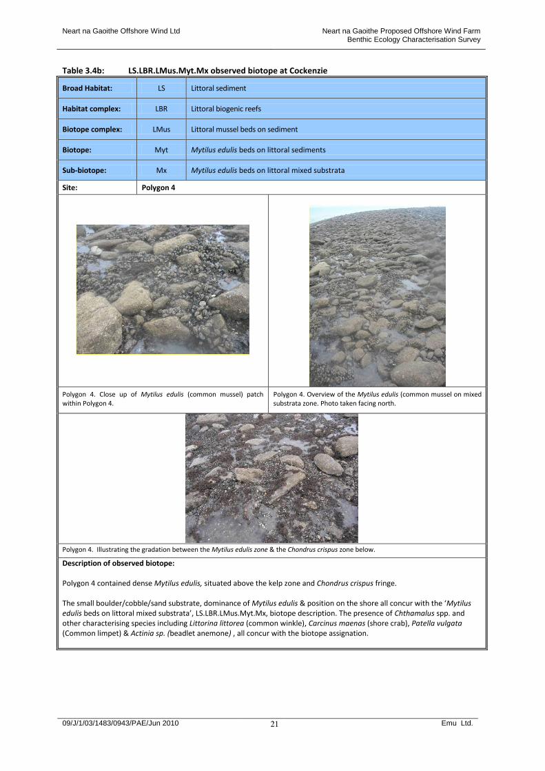
Table 3.4b: LS.LBR.LMus.Myt.Mx observed biotope at Cockenzie
Broad Habitat: LS Littoral sediment
Habitat complex: LBR Littoral biogenic reefs
Biotope complex: LMus Littoral mussel beds on sediment
Biotope: Myt Mytilus edulis beds on littoral sediments
Sub-biotope: Mx Mytilus edulis beds on littoral mixed substrata
Site: Polygon 4
Polygon 4. Close up of Mytilus edulis (common mussel) patch within Polygon 4.
Polygon 4. Overview of the Mytilus edulis (common mussel on mixed substrata zone. Photo taken facing north.
Polygon 4. Illustrating the gradation between the Mytilus edulis zone & the Chondrus crispus zone below.
Description of observed biotope: Polygon 4 contained dense Mytilus edulis, situated above the kelp zone and Chondrus crispus fringe. The small boulder/cobble/sand substrate, dominance of Mytilus edulis & position on the shore all concur with the ‘Mytilus edulis beds on littoral mixed substrata’, LS.LBR.LMus.Myt.Mx, biotope description. The presence of Chthamalus spp. and other characterising species including Littorina littorea (common winkle), Carcinus maenas (shore crab), Patella vulgata (Common limpet) & Actinia sp. (beadlet anemone) , all concur with the biotope assignation.
Neart na Gaoithe Offshore Wind Ltd Neart na Gaoithe Proposed Offshore Wind Farm Benthic Ecology Characterisation Survey
09/J/1/03/1483/0943/PAE/Jun 2010 Emu Ltd.
22
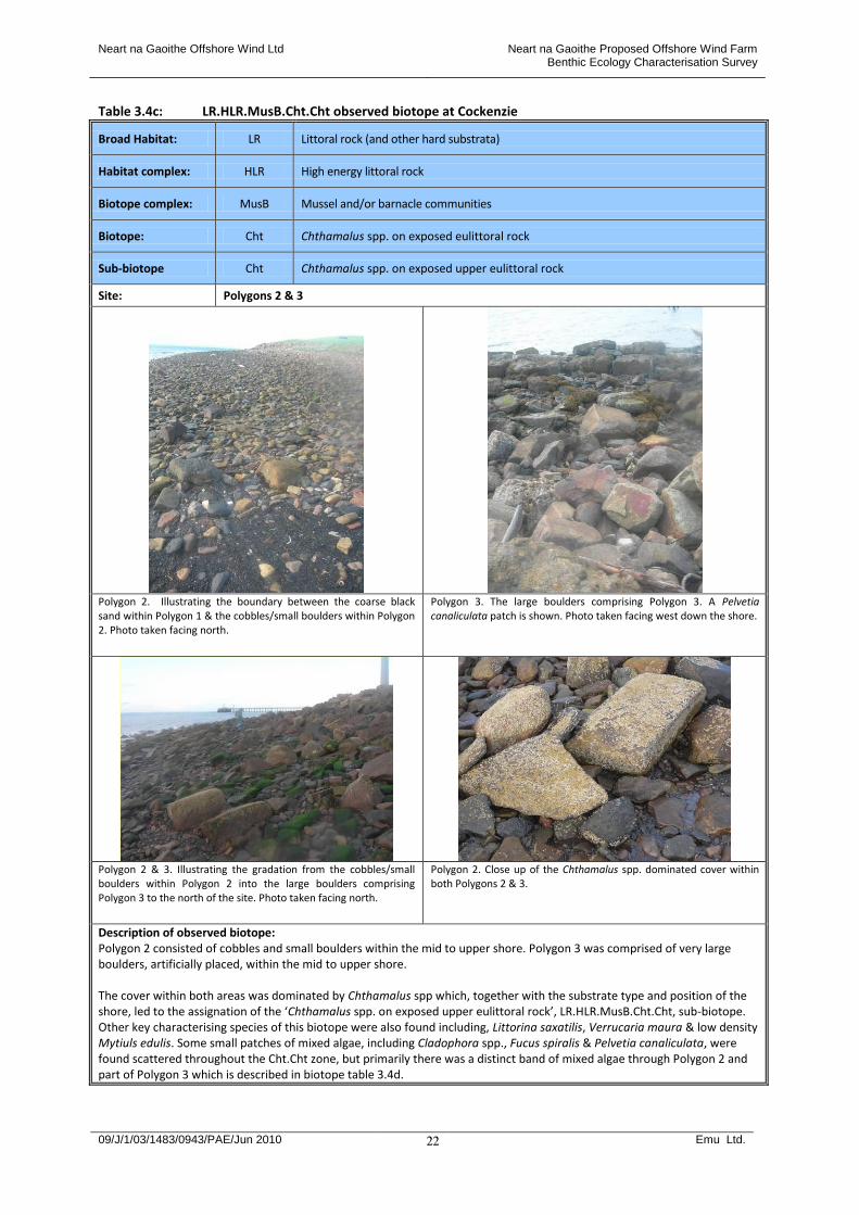
Table 3.4c: LR.HLR.MusB.Cht.Cht observed biotope at Cockenzie
Broad Habitat: LR Littoral rock (and other hard substrata)
Habitat complex: HLR High energy littoral rock
Biotope complex: MusB Mussel and/or barnacle communities
Biotope: Cht Chthamalus spp. on exposed eulittoral rock
Sub-biotope Cht Chthamalus spp. on exposed upper eulittoral rock
Site: Polygons 2 & 3
Polygon 2. Illustrating the boundary between the coarse black sand within Polygon 1 & the cobbles/small boulders within Polygon 2. Photo taken facing north.
Polygon 3. The large boulders comprising Polygon 3. A Pelvetia canaliculata patch is shown. Photo taken facing west down the shore.
Polygon 2 & 3. Illustrating the gradation from the cobbles/small boulders within Polygon 2 into the large boulders comprising Polygon 3 to the north of the site. Photo taken facing north.
Polygon 2. Close up of the Chthamalus spp. dominated cover within both Polygons 2 & 3.
Description of observed biotope: Polygon 2 consisted of cobbles and small boulders within the mid to upper shore. Polygon 3 was comprised of very large boulders, artificially placed, within the mid to upper shore. The cover within both areas was dominated by Chthamalus spp which, together with the substrate type and position of the shore, led to the assignation of the ‘Chthamalus spp. on exposed upper eulittoral rock’, LR.HLR.MusB.Cht.Cht, sub-biotope. Other key characterising species of this biotope were also found including, Littorina saxatilis, Verrucaria maura & low density Mytiuls edulis. Some small patches of mixed algae, including Cladophora spp., Fucus spiralis & Pelvetia canaliculata, were found scattered throughout the Cht.Cht zone, but primarily there was a distinct band of mixed algae through Polygon 2 and part of Polygon 3 which is described in biotope table 3.4d.
Neart na Gaoithe Offshore Wind Ltd Neart na Gaoithe Proposed Offshore Wind Farm Benthic Ecology Characterisation Survey
09/J/1/03/1483/0943/PAE/Jun 2010 Emu Ltd.
23
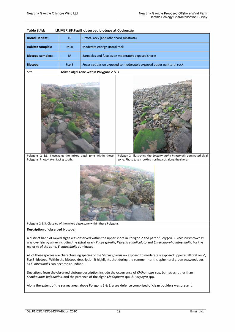
Table 3.4d: LR.MLR.BF.FspiB observed biotope at Cockenzie
Broad Habitat: LR Littoral rock (and other hard substrata)
Habitat complex: MLR Moderate energy littoral rock
Biotope complex: BF Barnacles and fucoids on moderately exposed shores
Biotope: FspiB Fucus spiralis on exposed to moderately exposed upper eulittoral rock
Site: Mixed algal zone within Polygons 2 & 3
Polygons 2 &3. Illustrating the mixed algal zone within these Polygons. Photo taken facing south.
Polygon 2. Illustrating the Enteromorpha intestinalis dominated algal zone. Photo taken looking northwards along the shore.
Polygons 2 & 3. Close up of the mixed algae zone within these Polygons.
Description of observed biotope: A distinct band of mixed algae was observed within the upper shore in Polygon 2 and part of Polygon 3. Verrucaria mucosa was overlain by algae including the spiral wrack Fucus spiralis, Pelvetia canaliculata and Enteromorpha intestinalis. For the majority of the zone, E. intestinalis dominated. All of these species are characterising species of the ‘Fucus spiralis on exposed to moderately exposed upper eulittoral rock’, FspiB, biotope. Within the biotope description it highlights that during the summer months ephemeral green seaweeds such as E. intestinalis can become abundant. Deviations from the observed biotope description include the occurrence of Chthamalus spp. barnacles rather than Semibalanus balanoides, and the presence of the algae Cladophora spp. & Porphyra spp. Along the extent of the survey area, above Polygons 2 & 3, a sea defence comprised of clean boulders was present.

Neart na Gaoithe Offshore Wind Ltd Neart na Gaoithe Proposed Offshore Wind Farm Benthic Ecology Characterisation Survey
09/J/1/03/1483/0943/PAE/Jun 2010 Emu Ltd.
24
Table 3.4e: LS.LSa.MoSa.BarSa observed biotope at Cockenzie
Broad Habitat: LS Littoral sediment
Habitat complex: LSa Littoral sand
Biotope complex: MoSa Barren or amphipod-dominated mobile sand shores
Biotope: BarSa Barren littoral coarse sand
Site: Polygon 1 – upper shore
Polygon 1. Illustrating the mixed coarse sand & pebbles within the upper shore in Polygon 1. Photo taken facing south.
Polygon 1. The upper shore substrate within Polygon 1, comprising coarse sand & pebbles. The gradation in the lower shore black sand with water channels within Polygon 1 can be seen. Photo taken facing north west.
Description of observed biotope: Polygon 1 consisted of 2 biotopes. Within the lower shore area in Polygon 1 the ‘Amphipods and Scolelepis spp. in littoral medium-fine sand’, AmSco, biotope was assigned – see biotope table 3.4f. The afaunal coarse sand and pebbles within the upper shore in Polygon 1 were assigned the ‘Barren littoral coarse sand’, BarSa, biotope due to the lack of a macrofaunal community, the substrate type and position on the shore.
Neart na Gaoithe Offshore Wind Ltd Neart na Gaoithe Proposed Offshore Wind Farm Benthic Ecology Characterisation Survey
09/J/1/03/1483/0943/PAE/Jun 2010 Emu Ltd.
25
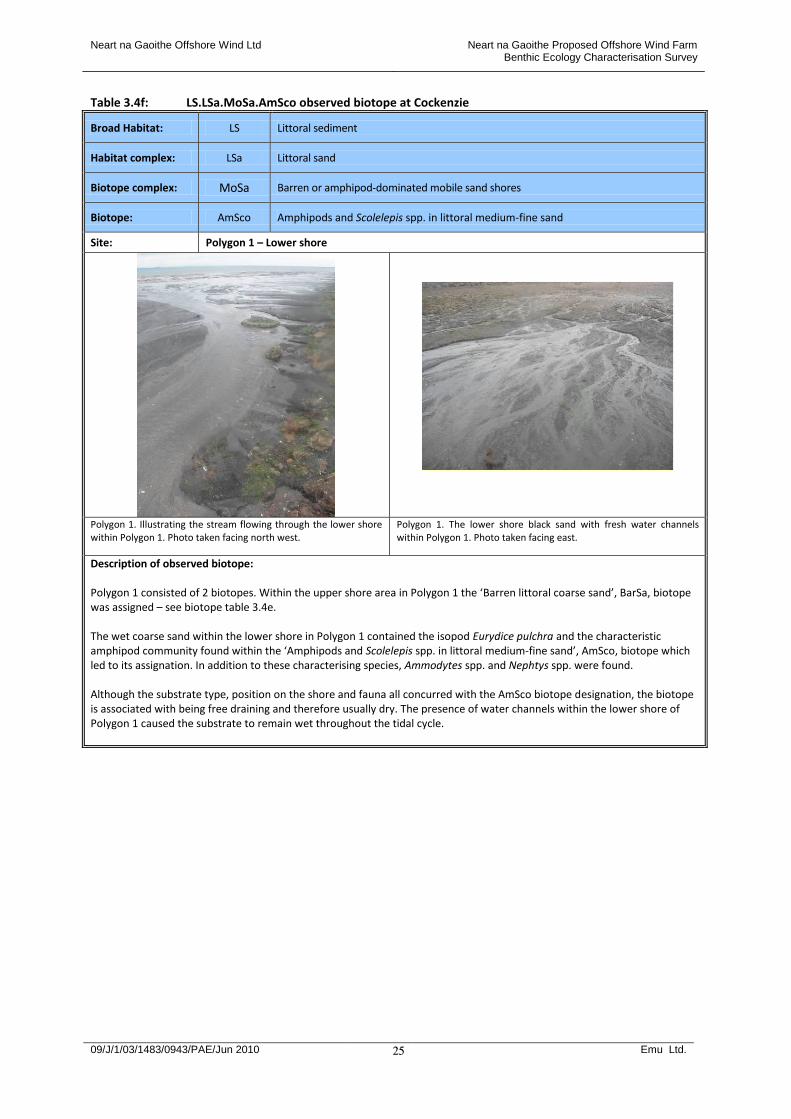
Table 3.4f: LS.LSa.MoSa.AmSco observed biotope at Cockenzie
Broad Habitat: LS Littoral sediment
Habitat complex: LSa Littoral sand
Biotope complex: MoSa Barren or amphipod-dominated mobile sand shores
Biotope: AmSco Amphipods and Scolelepis spp. in littoral medium-fine sand
Site: Polygon 1 – Lower shore
Polygon 1. Illustrating the stream flowing through the lower shore within Polygon 1. Photo taken facing north west.
Polygon 1. The lower shore black sand with fresh water channels within Polygon 1. Photo taken facing east.
Description of observed biotope: Polygon 1 consisted of 2 biotopes. Within the upper shore area in Polygon 1 the ‘Barren littoral coarse sand’, BarSa, biotope was assigned – see biotope table 3.4e. The wet coarse sand within the lower shore in Polygon 1 contained the isopod Eurydice pulchra and the characteristic amphipod community found within the ‘Amphipods and Scolelepis spp. in littoral medium-fine sand’, AmSco, biotope which led to its assignation. In addition to these characterising species, Ammodytes spp. and Nephtys spp. were found. Although the substrate type, position on the shore and fauna all concurred with the AmSco biotope designation, the biotope is associated with being free draining and therefore usually dry. The presence of water channels within the lower shore of Polygon 1 caused the substrate to remain wet throughout the tidal cycle.
Neart na Gaoithe Offshore Wind Ltd Neart na Gaoithe Proposed Offshore Wind Farm Benthic Ecology Characterisation Survey
09/J/1/03/1483/0943/PAE/Jun 2010 Emu Ltd.
26
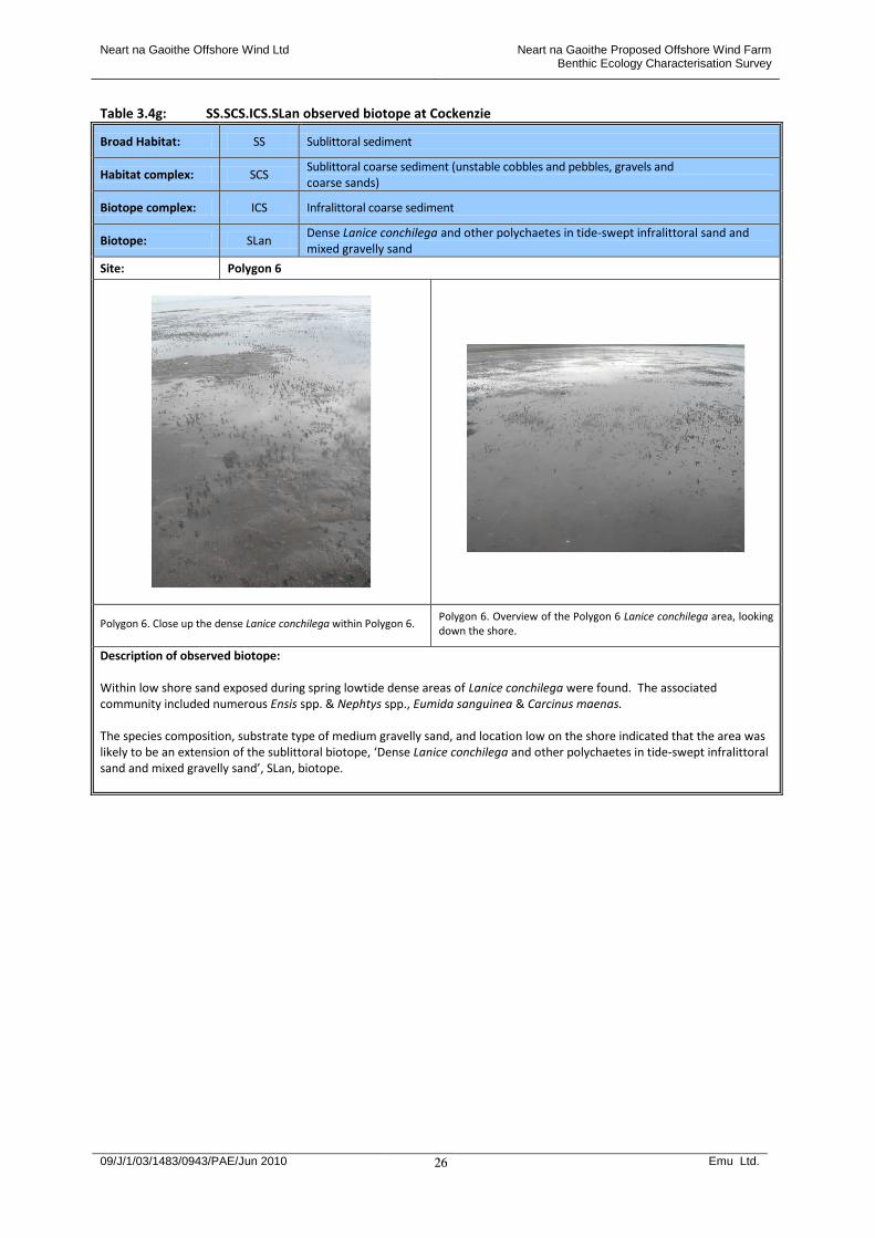
Table 3.4g: SS.SCS.ICS.SLan observed biotope at Cockenzie
Broad Habitat: SS Sublittoral sediment
Habitat complex: SCS Sublittoral coarse sediment (unstable cobbles and pebbles, gravels and coarse sands)
Biotope complex: ICS Infralittoral coarse sediment
Biotope: SLan Dense Lanice conchilega and other polychaetes in tide-swept infralittoral sand and mixed gravelly sand
Site: Polygon 6
Polygon 6. Close up the dense Lanice conchilega within Polygon 6. Polygon 6. Overview of the Polygon 6 Lanice conchilega area, looking down the shore.
Description of observed biotope: Within low shore sand exposed during spring lowtide dense areas of Lanice conchilega were found. The associated community included numerous Ensis spp. & Nephtys spp., Eumida sanguinea & Carcinus maenas. The species composition, substrate type of medium gravelly sand, and location low on the shore indicated that the area was likely to be an extension of the sublittoral biotope, ‘Dense Lanice conchilega and other polychaetes in tide-swept infralittoral sand and mixed gravelly sand’, SLan, biotope.

Neart na Gaoithe Offshore Wind Ltd Neart na Gaoithe Proposed Offshore Wind Farm Benthic Ecology Characterisation Survey
09/J/1/03/1483/0943/PAE/Jun 2010 Emu Ltd.
27
Table 3.4h: IR.MIR.KR.LhypTX observed biotope at Cockenzie
Broad Habitat: IR Infralittoral rock (and other hard substrata)
Habitat complex: MIR Moderate energy infralittoral rock
Biotope complex: KR Kelp and red seaweeds (moderate energy infralittoral rock)
Biotope: LhypTX Laminaria hyperborea on tide-swept infralittoral mixed substrata
Site: Polygon 5
Polygon 5. Close up of the Laminaria hyperborea zone comprising Polygon 5.
Polygon 5. Overview of the Laminaria hyperborea zone at Cockenzie. Photo taken facing south west.
Description of observed biotope: The Laminaria hyperborea covered boulders/cobbles/gravel within the infralittoral zone were assigned the ‘Laminaria hyperborea on tide-swept infralittoral mixed substrata’, IR.MIR.LhypTX, biotope. The substrate type, position within the infralittoral and dominance of L. hyperborea all concur with the LhypTX description. In addition, a number of the other characterising species occurred including, Plocamium cartilagineum, Membranipora membranacea, Pomotoceros triqueter and Asterias rubens.

Neart na Gaoithe Offshore Wind Ltd Neart na Gaoithe Proposed Offshore Wind Farm Benthic Ecology Characterisation Survey
09/J/1/03/1483/0943/PAE/Jun 2010 Emu Ltd.
28
Table 3.4i: Observed clean boulder sea defence at Cockenzie
Feature: Boulder sea defence along the length of the survey area
Description Clean boulders, artificially placed along the upper shore as a form of sea defence.
Biotope distribution at Cockenzie 3.9 A total of 59 species were found in the intertidal survey at Cockenzie (Appendix IV). Appendix V
contains the field descriptions of all the polygons and target notes observed at Cockenzie. 3.10 Cockenzie was the least biologically diverse area (in terms of numbers of biotopes present) out of the 3
potential cable landfall sites surveyed. Within the area surveyed, Cockenzie consisted of a largely modified shore with sea defences, ranging from small to significant boulders, along the upper shore. Areas of interest were exposed during low water, with apparently ‘natural’ pebble/cobble/boulder areas revealed and an extended area of flat, coarse, black, sand with numerous areas of freshwater flow to the south of the survey area.
3.11 Classic zonation patterns were observed. Below the boulder sea defence, a zone of cobbles/small
boulders was present grading into large boulders, moving northwards. This area was dominated by the barnacle species typical of more exposed sites, Chthamalus spp., LR.HLR.MusB.Cht.Cht. Associated with this zone were classic upper shore species including Verrucaria maura, and the upper shore algae spp. Fucus spiralis and Pelvetia canaliculata, mainly present within a distinct band within the area, LR.MLR.BF.FspiB. Enteromorpha intestinalis, an ephemeral alga capable of withstanding a high degree of exposure and sand scour, was abundant.
3.12 A zone of dense Mytlius edulis on mixed substrata, LS.LBR.LMus.Myt.Mx, was present below the
Chthamalus spp. dominated area. Between the M.edulis zone and the kelp zone, IR.MIR.KR.LhypTX, a Chondrus crispus dominated area was observed, LR.HLR.FR.Mas.
3.13 At the southern end of the survey area, the upper shore consisted of afaunal coarse sand with pebbles,
LS.LSa.MoSa.BarSa. This biotope is characteristic of more exposed shores subject to a high degree of sediment disturbance. They are naturally impoverished due to compaction and abrasion forces and the inability of fauna to maintain position.
3.14 As is typical of more exposed shores, below the upper shore barren sand relatively more species rich
mobile sand communities occurred. In the mid-lower shore an area of wet coarse sand was present, dissected by multiple freshwater channels. This contained the characteristic amphipod community associated with the LS.LSa.MoSa.AmSco biotope. The low shore sand (below the amphipod dominated sand area) was dominated by Lanice conchilega, with numerous Ensis spp. present. The species
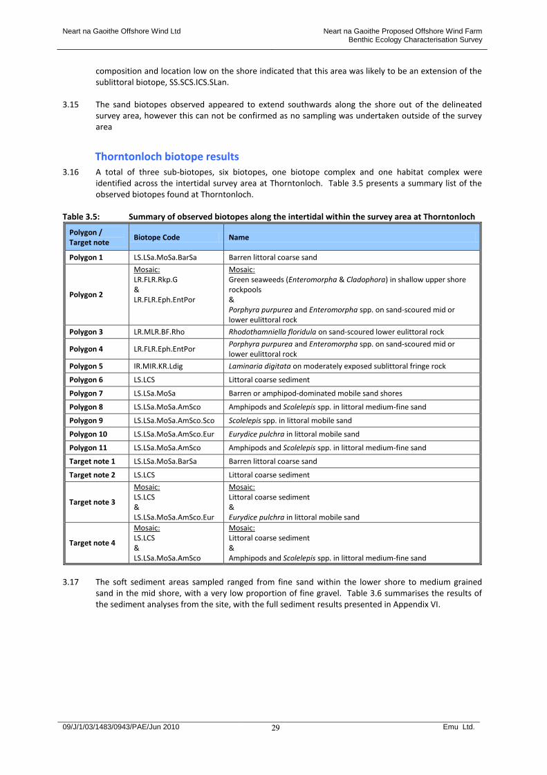
Neart na Gaoithe Offshore Wind Ltd Neart na Gaoithe Proposed Offshore Wind Farm Benthic Ecology Characterisation Survey
09/J/1/03/1483/0943/PAE/Jun 2010 Emu Ltd.
29
composition and location low on the shore indicated that this area was likely to be an extension of the sublittoral biotope, SS.SCS.ICS.SLan.
3.15 The sand biotopes observed appeared to extend southwards along the shore out of the delineated
survey area, however this can not be confirmed as no sampling was undertaken outside of the survey area
Thorntonloch biotope results 3.16 A total of three sub-biotopes, six biotopes, one biotope complex and one habitat complex were
identified across the intertidal survey area at Thorntonloch. Table 3.5 presents a summary list of the observed biotopes found at Thorntonloch.
Table 3.5: Summary of observed biotopes along the intertidal within the survey area at Thorntonloch
Polygon / Target note
Biotope Code Name
Polygon 1 LS.LSa.MoSa.BarSa Barren littoral coarse sand
Polygon 2
Mosaic: LR.FLR.Rkp.G & LR.FLR.Eph.EntPor
Mosaic: Green seaweeds (Enteromorpha & Cladophora) in shallow upper shore rockpools & Porphyra purpurea and Enteromorpha spp. on sand-scoured mid or lower eulittoral rock
Polygon 3 LR.MLR.BF.Rho Rhodothamniella floridula on sand-scoured lower eulittoral rock
Polygon 4 LR.FLR.Eph.EntPor Porphyra purpurea and Enteromorpha spp. on sand-scoured mid or lower eulittoral rock
Polygon 5 IR.MIR.KR.Ldig Laminaria digitata on moderately exposed sublittoral fringe rock
Polygon 6 LS.LCS Littoral coarse sediment
Polygon 7 LS.LSa.MoSa Barren or amphipod-dominated mobile sand shores
Polygon 8 LS.LSa.MoSa.AmSco Amphipods and Scolelepis spp. in littoral medium-fine sand
Polygon 9 LS.LSa.MoSa.AmSco.Sco Scolelepis spp. in littoral mobile sand
Polygon 10 LS.LSa.MoSa.AmSco.Eur Eurydice pulchra in littoral mobile sand
Polygon 11 LS.LSa.MoSa.AmSco Amphipods and Scolelepis spp. in littoral medium-fine sand
Target note 1 LS.LSa.MoSa.BarSa Barren littoral coarse sand
Target note 2 LS.LCS Littoral coarse sediment
Target note 3
Mosaic: LS.LCS & LS.LSa.MoSa.AmSco.Eur
Mosaic: Littoral coarse sediment & Eurydice pulchra in littoral mobile sand
Target note 4
Mosaic: LS.LCS & LS.LSa.MoSa.AmSco
Mosaic: Littoral coarse sediment & Amphipods and Scolelepis spp. in littoral medium-fine sand
3.17 The soft sediment areas sampled ranged from fine sand within the lower shore to medium grained
sand in the mid shore, with a very low proportion of fine gravel. Table 3.6 summarises the results of the sediment analyses from the site, with the full sediment results presented in Appendix VI.
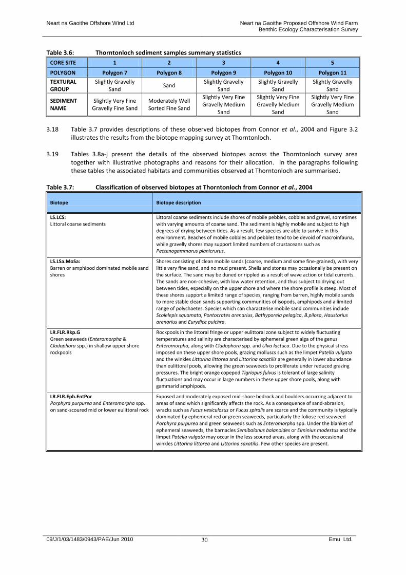
Neart na Gaoithe Offshore Wind Ltd Neart na Gaoithe Proposed Offshore Wind Farm Benthic Ecology Characterisation Survey
09/J/1/03/1483/0943/PAE/Jun 2010 Emu Ltd.
30
Table 3.6: Thorntonloch sediment samples summary statistics
CORE SITE 1 2 3 4 5
POLYGON Polygon 7 Polygon 8 Polygon 9 Polygon 10 Polygon 11
TEXTURAL GROUP
Slightly Gravelly Sand
Sand Slightly Gravelly
Sand Slightly Gravelly
Sand Slightly Gravelly
Sand
SEDIMENT NAME
Slightly Very Fine Gravelly Fine Sand
Moderately Well Sorted Fine Sand
Slightly Very Fine Gravelly Medium
Sand
Slightly Very Fine Gravelly Medium
Sand
Slightly Very Fine Gravelly Medium
Sand
3.18 Table 3.7 provides descriptions of these observed biotopes from Connor et al., 2004 and Figure 3.2
illustrates the results from the biotope mapping survey at Thorntonloch. 3.19 Tables 3.8a-j present the details of the observed biotopes across the Thorntonloch survey area
together with illustrative photographs and reasons for their allocation. In the paragraphs following these tables the associated habitats and communities observed at Thorntonloch are summarised.
Table 3.7: Classification of observed biotopes at Thorntonloch from Connor et al., 2004
Biotope Biotope description
LS.LCS: Littoral coarse sediments
Littoral coarse sediments include shores of mobile pebbles, cobbles and gravel, sometimes with varying amounts of coarse sand. The sediment is highly mobile and subject to high degrees of drying between tides. As a result, few species are able to survive in this environment. Beaches of mobile cobbles and pebbles tend to be devoid of macroinfauna, while gravelly shores may support limited numbers of crustaceans such as Pectenogammarus planicrurus.
LS.LSa.MoSa: Barren or amphipod dominated mobile sand shores
Shores consisting of clean mobile sands (coarse, medium and some fine-grained), with very little very fine sand, and no mud present. Shells and stones may occasionally be present on the surface. The sand may be duned or rippled as a result of wave action or tidal currents. The sands are non-cohesive, with low water retention, and thus subject to drying out between tides, especially on the upper shore and where the shore profile is steep. Most of these shores support a limited range of species, ranging from barren, highly mobile sands to more stable clean sands supporting communities of isopods, amphipods and a limited range of polychaetes. Species which can characterise mobile sand communities include Scolelepis squamata, Pontocrates arenarius, Bathyporeia pelagica, B.pilosa, Haustorius arenarius and Eurydice pulchra.
LR.FLR.Rkp.G Green seaweeds (Enteromorpha & Cladophora spp.) in shallow upper shore rockpools
Rockpools in the littoral fringe or upper eulittoral zone subject to widely fluctuating temperatures and salinity are characterised by ephemeral green alga of the genus Enteromorpha, along with Cladophora spp. and Ulva lactuca. Due to the physical stress imposed on these upper shore pools, grazing molluscs such as the limpet Patella vulgata and the winkles Littorina littorea and Littorina saxatilis are generally in lower abundance than eulittoral pools, allowing the green seaweeds to proliferate under reduced grazing pressures. The bright orange copepod Tigriopus fulvus is tolerant of large salinity fluctuations and may occur in large numbers in these upper shore pools, along with gammarid amphipods.
LR.FLR.Eph.EntPor Porphyra purpurea and Enteromorpha spp. on sand-scoured mid or lower eulittoral rock
Exposed and moderately exposed mid-shore bedrock and boulders occurring adjacent to areas of sand which significantly affects the rock. As a consequence of sand-abrasion, wracks such as Fucus vesiculosus or Fucus spiralis are scarce and the community is typically dominated by ephemeral red or green seaweeds, particularly the foliose red seaweed Porphyra purpurea and green seaweeds such as Enteromorpha spp. Under the blanket of ephemeral seaweeds, the barnacles Semibalanus balanoides or Elminius modestus and the limpet Patella vulgata may occur in the less scoured areas, along with the occasional winkles Littorina littorea and Littorina saxatilis. Few other species are present.
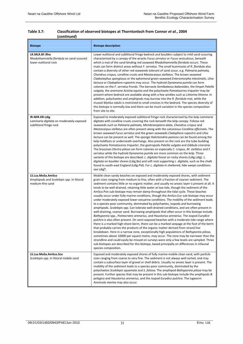
Neart na Gaoithe Offshore Wind Ltd Neart na Gaoithe Proposed Offshore Wind Farm Benthic Ecology Characterisation Survey
09/J/1/03/1483/0943/PAE/Jun 2010 Emu Ltd.
31
Table 3.7: Classification of observed biotopes at Thorntonloch from Connor et al., 2004 (continued)
Biotope Biotope description
LR.MLR.BF.Rho Rhodothamniella floridula on sand-scoured lower eulittoral rock
Lower eulittoral and sublittoral fringe bedrock and boulders subject to mild sand-scouring characterised by a canopy of the wracks Fucus serratus or Fucus vesiculosus, beneath which a mat of the sand-binding red seaweed Rhodothamniella floridula occurs. These mats can form distinct areas without F. serratus. The small hummocks of R. floridula also contain a diversity of other red seaweeds tolerant of sand scour, e.g. Palmaria palmata, Chondrus crispus, coralline crusts and Mastocarpus stellatus. The brown seaweed Cladostephus spongiosus or the ephemeral green seaweed Enteromorpha intestinalis, Ulva lactuca or Cladophora rupestris may occur. The hydroid Dynamena pumila can form colonies on the F. serratus fronds. The barnacle Semibalanus balanoides, the limpet Patella vulgata, the anemone Actinia equina and the polychaete Pomatoceros triqueter may be present where bedrock are available along with a few winkles such as Littorina littorea. In addition, polychaetes and amphipods may burrow into the R. floridula mat, while the mussel Mytilus edulis is restricted to small crevices in the bedrock. The species diversity of this biotope is normally low and there can be much variation in the species composition from site to site.
IR.MIR.KR.Ldig Laminaria digitata on moderately exposed sublittoral fringe rock
Exposed to moderately exposed sublittoral fringe rock characterised by the kelp Laminaria digitata with coralline crusts covering the rock beneath the kelp canopy. Foliose red seaweeds such as Palmaria palmata, Membranoptera alata, Chondrus crispus and Mastocarpus stellatus are often present along with the calcareous Corallina officinalis. The brown seaweed Fucus serratus and the green seaweeds Cladophora rupestris and Ulva lactuca can be present as well. The sponge Halichondria panicea can be found among the kelp holdfasts or underneath overhangs. Also present on the rock are the tube-building polychaete Pomatoceros triqueter, the gastropods Patella vulgata and Gibbula cineraria. The bryozoan Electra pilosa can form colonies on especially C. crispus, M. stellatus and F. serratus while the hydroid Dynanema pumila are more common on the kelp. Three variants of this biotope are described: L. digitata forest on rocky shores (Ldig.Ldig). L. digitata on boulder shores (Ldig.Bo) and soft rock supporting L. digitata, such as the chalk found in south-east England (Ldig.Pid). For L. digitata in sheltered, tide-swept conditions see LdigT.
LS.Lsa.MoSa.AmSco Amphipods and Scolelepis spp. In littoral medium-fine sand
Mobile clean sandy beaches on exposed and moderately exposed shores, with sediment grain sizes ranging from medium to fine, often with a fraction of coarser sediment. The sediment contains little or no organic matter, and usually no anoxic layer is present at all. It tends to be well-drained, retaining little water at low tide, though the sediment of the AmSco.Pon sub-biotope may remain damp throughout the tidal cycle. These beaches usually occur under fully marine conditions, though the AmSco.Eur sub-biotope may occur under moderately exposed lower estuarine conditions. The mobility of the sediment leads to a species-poor community, dominated by polychaetes, isopods and burrowing amphipods. Scolelepis spp. Can tolerate well-drained conditions, and are often present in well-draining, coarser sand. Burrowing amphipods that often occur in this biotope include Bathyporeia spp., Pontocrates arenarius, and Haustorius arenarius. The isopod Eurydice pulchra is also often present. On semi-exposed beaches with a moderate tide range where there is a marked high-shore berm, there can be a marked seepage at the foot of the berm that probably carries the products of the organic matter derived from strand line breakdown. Here in a narrow zone, exceptionally high populations of Bathyporeia pilosa, sometimes above 10000 per square metre, may occur. The zone may be narrower than the strandline and could easily be missed on surveys were only a few levels are sampled. Three sub-biotopes are described for this biotope, based principally on differences in infaunal species composition.
LS.Lsa.MoSa.AmSco.Sco Scolelepis spp. In littoral mobile sand
Exposed and moderately exposed shores of fully marine mobile clean sand, with particle sizes ranging from coarse to very fine. The sediment is not always well sorted, and may contain a subsurface layer of gravel or shell debris. Usually no anoxic layer is present. The mobility of the sediment leads to a species-poor community, dominated by the polychaetes Scolelepis squamata and S. foliosa. The amphipod Bathyporeia pilosa may be present. Further species that may be present in this sub-biotope include the amphipods B. pelagica and Haustorius arenarius, and the isopod Eurydice pulchra. The lugworm Arenicola marina may also occur.
Neart na Gaoithe Offshore Wind Ltd Neart na Gaoithe Proposed Offshore Wind Farm Benthic Ecology Characterisation Survey
09/J/1/03/1483/0943/PAE/Jun 2010 Emu Ltd.
32
Table 3.7: Classification of observed biotopes at Thorntonloch from Connor et al., 2004 (continued)
Biotope Biotope description
LS.Lsa.MoSa.AmSco.Eur Eurydice pulchra in littoral mobile sand
Well-draining beaches of medium- to fine-grained mobile sand, often (but not always) well sorted. Occasionally, a small fraction of coarse sand may be present. The biotope generally occurs on exposed open coasts, but sometimes in estuarine conditions, supporting populations of the isopod Eurydice pulchra and burrowing amphipods which frequently include Bathyporeia pilosa and Haustorius arenarius. The degree of drainage appears to be a critical factor in determining the presence of polychaetes, with only Scolelepis squamata capable of tolerating the well-drained sediments of this biotope. This biotope has two facies: drying upper and mid shore sands, and highly mobile lower shore and shallow sublittoral sand bars. Where this biotope occurs in estuarine conditions, H. arenarius is often highly abundant.
LS.Lsa.MoSa.BarSa Barren littoral coarse sand
Freely-draining sandy beaches, particularly on the upper and mid shore, which lack a macrofaunal community due to their continual mobility. Trial excavations are unlikely to reveal any macrofauna in these typically steep beaches on exposed coasts. Oligochaetes, probably mainly enchytraeids, and the isopod Eurydice pulchra may be found in extremely low abundances, but if present in any quantity should be classed as Ol or AmSco.Eur. Burrowing amphipods (Bathyporeia spp.) may be present on very rare occasions. Occasionally, other species may be left behind in low abundance by the ebbing tide.
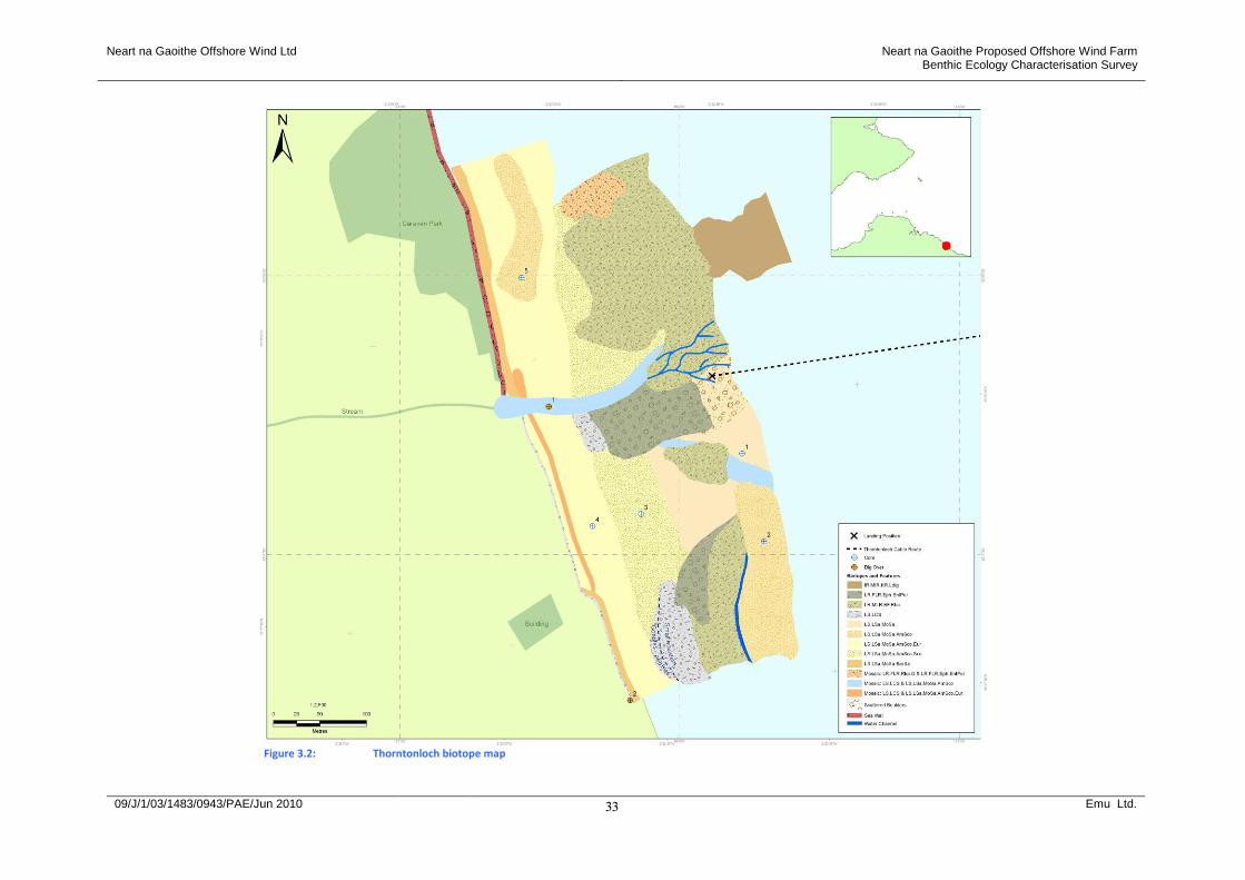
Neart na Gaoithe Offshore Wind Ltd Neart na Gaoithe Proposed Offshore Wind Farm Benthic Ecology Characterisation Survey
09/J/1/03/1483/0943/PAE/Jun 2010 Emu Ltd.
33
Figure 3.2: Thorntonloch biotope map
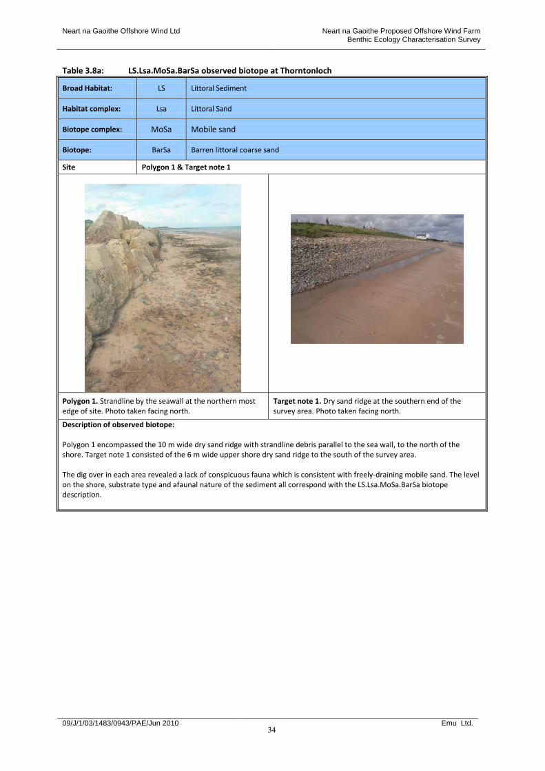
Neart na Gaoithe Offshore Wind Ltd Neart na Gaoithe Proposed Offshore Wind Farm Benthic Ecology Characterisation Survey
09/J/1/03/1483/0943/PAE/Jun 2010 Emu Ltd.
34
Table 3.8a: LS.Lsa.MoSa.BarSa observed biotope at Thorntonloch
Broad Habitat: LS Littoral Sediment
Habitat complex: Lsa Littoral Sand
Biotope complex: MoSa Mobile sand
Biotope: BarSa Barren littoral coarse sand
Site Polygon 1 & Target note 1
Polygon 1. Strandline by the seawall at the northern most edge of site. Photo taken facing north.
Target note 1. Dry sand ridge at the southern end of the survey area. Photo taken facing north.
Description of observed biotope: Polygon 1 encompassed the 10 m wide dry sand ridge with strandline debris parallel to the sea wall, to the north of the shore. Target note 1 consisted of the 6 m wide upper shore dry sand ridge to the south of the survey area. The dig over in each area revealed a lack of conspicuous fauna which is consistent with freely-draining mobile sand. The level on the shore, substrate type and afaunal nature of the sediment all correspond with the LS.Lsa.MoSa.BarSa biotope description.

Neart na Gaoithe Offshore Wind Ltd Neart na Gaoithe Proposed Offshore Wind Farm Benthic Ecology Characterisation Survey
09/J/1/03/1483/0943/PAE/Jun 2010 Emu Ltd.
35
Table 3.8b: LS.Lsa.MoSa observed biotope complex at Thorntonloch
Broad Habitat: LS Littoral Sediments
Habitat complex: Lsa Littoral sands and muddy sands
Biotope complex: MoSa Barren or amphipod dominated mobile sand shores
Site Polygon 7
Polygon 7. Close up of the amphipod dominated sand found in an area of the lower shore at Thorntonloch.
Polygon 7. Overview – looking west towards the land to from Polygon 7.
Description of observed biotope: Polygon 7 consisted of the area of wet sand within the lower shore, in the centre of the survey area. PSA analysis defined the substrate in this area as slightly gravelly fine sand. Lab analyses of the fauna indicated that the amphipod Haustorius arenarius, dominated. The level on the shore, substrate type and species composition revealed by the laboratory analyses all concur with the MoSa biotope complex description. Although the sands associated with this biotope complex are typically described as non-cohesive with low water retention, Polygon 7 consisted of wet sand, perhaps due to a combination of its location lower down the shore, the presence of a stream dissecting the area and the relatively shallow shore profile. The biotope assignation remained at biotope complex level for this Polygon, as the three key characterising species associated with the LS.Lsa.MoSa.AmSco biotope were not observed, aside from 1 Scolelepis.
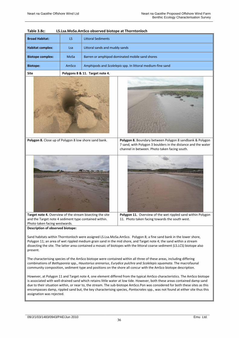
Neart na Gaoithe Offshore Wind Ltd Neart na Gaoithe Proposed Offshore Wind Farm Benthic Ecology Characterisation Survey
09/J/1/03/1483/0943/PAE/Jun 2010 Emu Ltd.
36
Table 3.8c: LS.Lsa.MoSa.AmSco observed biotope at Thorntonloch
Broad Habitat: LS Littoral Sediments
Habitat complex: Lsa Littoral sands and muddy sands
Biotope complex: MoSa Barren or amphipod dominated mobile sand shores
Biotope: AmSco Amphipods and Scolelepis spp. In littoral medium-fine sand
Site Polygons 8 & 11. Target note 4.
Polygon 8. Close up of Polygon 8 low shore sand bank. Polygon 8. Boundary between Polygon 8 sandbank & Polygon 7 sand, with Polygon 3 boulders in the distance and the water channel in between. Photo taken facing south.
Target note 4. Overview of the stream bisecting the site and the Target note 4 sediment type contained within. Photo taken facing westwards.
Polygon 11. Overview of the wet rippled sand within Polygon 11. Photo taken facing towards the south west.
Description of observed biotope: Sand habitats within Thorntonloch were assigned LS.Lsa.MoSa.AmSco. Polygon 8; a fine sand bank in the lower shore, Polygon 11; an area of wet rippled medium grain sand in the mid shore, and Target note 4; the sand within a stream dissecting the site. The latter area contained a mosaic of biotopes with the littoral coarse sediment (LS.LCS) biotope also present. The characterising species of the AmSco biotope were contained within all three of these areas, including differing combinations of Bathyporeia spp., Haustorius arenarius, Eurydice pulchra and Scolelepis squamata. The macrofaunal community composition, sediment type and positions on the shore all concur with the AmSco biotope description. However, at Polygon 11 and Target note 4, one element differed from the typical AmSco characteristics. The AmSco biotope is associated with well-drained sand which retains little water at low tide. However, both these areas contained damp sand due to their situation within, or near to, the stream. The sub-biotope AmSco.Pon was considered for both these sites as this encompasses damp, rippled sand but, the key characterising species, Pontocrates spp., was not found at either site thus this assignation was rejected.

Neart na Gaoithe Offshore Wind Ltd Neart na Gaoithe Proposed Offshore Wind Farm Benthic Ecology Characterisation Survey
09/J/1/03/1483/0943/PAE/Jun 2010 Emu Ltd.
37
Table 3.8d: LS.Lsa.MoSa.AmSco.Eur observed sub-biotope at Thorntonloch
Broad Habitat: LS Littoral Sediments
Habitat complex: Lsa Littoral sands and muddy sands
Biotope complex: MoSa Barren or amphipod dominated mobile sand shores
Biotope: AmSco Amphipods and Scolelepis spp. In littoral medium-fine sand
Sub-biotope Eur Eurydice pulchra on littoral mobile sand
Site Polygon 10 & Target note 3
Polygon 10. Close up of the slightly gravelly medium grain sand within Polygon 10.
Polygon 10. Overview of the mid shore dune area, looking to the north of the site.
Target note 3. Overview of the sand/gravel/cobble area linked to the stream, facing north.
Description of observed biotope: Polygon 10 encompassed the mid shore dune area extending across the survey site and Target note 3 refers to the wet sand element of the sand, gravel and cobble area linked to the stream in the mid shore. A mosaic of biotopes was assigned to the Target note 3 site, with the littoral coarse sediment biotope, LS.LCS, assigned to incorporate the gravel/cobble element in the area. Both sites contained the characteristic amphipod community and substrate type associated with the AmSco biotope. The dominance of Eurydice Pulchra within these areas led to the assignation of the Eurydice Pulchra in littoral mobile sand sub-biotope: AmSco.Eur. Polygon 10 contained some damp areas within which a similar macrofaunal community to Polygon 11, the LS.Lsa.MoSa.AmSco biotope, was found.
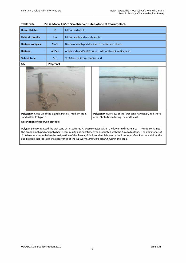
Neart na Gaoithe Offshore Wind Ltd Neart na Gaoithe Proposed Offshore Wind Farm Benthic Ecology Characterisation Survey
09/J/1/03/1483/0943/PAE/Jun 2010 Emu Ltd.
38
Table 3.8e: LS.Lsa.MoSa.AmSco.Sco observed sub-biotope at Thorntonloch
Broad Habitat: LS Littoral Sediments
Habitat complex: Lsa Littoral sands and muddy sands
Biotope complex: MoSa Barren or amphipod dominated mobile sand shores
Biotope: AmSco Amphipods and Scolelepis spp. In littoral medium-fine sand
Sub-biotope Sco Scolelepis in littoral mobile sand
Site Polygon 9
Polygon 9. Close up of the slightly gravelly, medium grain sand within Polygon 9.
Polygon 9. Overview of the ‘wet sand Arenicola’, mid shore area. Photo taken facing the north east.
Description of observed biotope: Polygon 9 encompassed the wet sand with scattered Arenicola castes within the lower mid shore area. The site contained the broad amphipod and polychaete community and substrate type associated with the AmSco biotope. The dominance of Scolelepis squamata led to the assignation of the Scolelepis in littoral mobile sand sub-biotope: AmSco.Sco. In addition, this sub-biotope incorporates the occurrence of the lug worm, Arenicola marina, within this area.
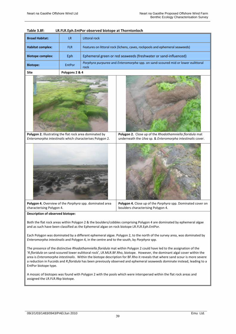
Neart na Gaoithe Offshore Wind Ltd Neart na Gaoithe Proposed Offshore Wind Farm Benthic Ecology Characterisation Survey
09/J/1/03/1483/0943/PAE/Jun 2010 Emu Ltd.
39
Table 3.8f: LR.FLR.Eph.EntPor observed biotope at Thorntonloch
Broad Habitat: LR Littoral rock
Habitat complex: FLR Features on littoral rock (lichens, caves, rockpools and ephemeral seaweeds)
Biotope complex: Eph Ephemeral green or red seaweeds (freshwater or sand-influenced)
Biotope: EntPor Porphyra purpurea and Enteromorpha spp. on sand-scoured mid or lower eulittoral rock
Site Polygons 2 & 4
Polygon 2. Illustrating the flat rock area dominated by Enteromorpha intestinalis which characterises Polygon 2.
Polygon 2. Close up of the Rhodothamniella floridula mat underneath the Ulva sp. & Enteromorpha intestinalis cover.
Polygon 4. Overview of the Porphyra spp. dominated area characterising Polygon 4.
Polygon 4. Close up of the Porphyra spp. Dominated cover on boulders characterising Polygon 4.
Description of observed biotope: Both the flat rock areas within Polygon 2 & the boulders/cobbles comprising Polygon 4 are dominated by ephemeral algae and as such have been classified as the Ephemeral algae on rock biotope LR.FLR.Eph.EntPor. Each Polygon was dominated by a different ephemeral algae. Polygon 2, to the north of the survey area, was dominated by Enteromorpha intestinalis and Polygon 4, in the centre and to the south, by Porphyra spp. The presence of the distinctive Rhodothamniella floridula mat within Polygon 2 could have led to the assignation of the ‘R.floridula on sand-scoured lower eulittoral rock’, LR.MLR.BF.Rho, biotope. However, the dominant algal cover within the area is Enteromorpha intestinalis. Within the biotope description for BF.Rho it reveals that where sand scour is more severe a reduction in Fucoids and R.floridula has been previously observed and ephemeral seaweeds dominate instead, leading to a EntPor biotope type. A mosaic of biotopes was found with Polygon 2 with the pools which were interspersed within the flat rock areas and assigned the LR.FLR.Rkp biotope.
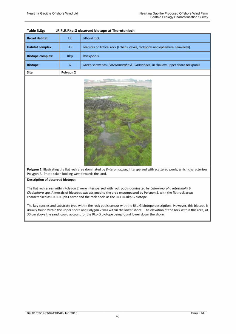
Neart na Gaoithe Offshore Wind Ltd Neart na Gaoithe Proposed Offshore Wind Farm Benthic Ecology Characterisation Survey
09/J/1/03/1483/0943/PAE/Jun 2010 Emu Ltd.
40
Table 3.8g: LR.FLR.Rkp.G observed biotope at Thorntonloch
Broad Habitat: LR Littoral rock
Habitat complex: FLR Features on littoral rock (lichens, caves, rockpools and ephemeral seaweeds)
Biotope complex: Rkp Rockpools
Biotope: G Green seaweeds (Enteromorpha & Cladophora) in shallow upper shore rockpools
Site Polygon 2
Polygon 2. Illustrating the flat rock area dominated by Enteromorpha, interspersed with scattered pools, which characterises Polygon 2. Photo taken looking west towards the land.
Description of observed biotope: The flat rock areas within Polygon 2 were interspersed with rock pools dominated by Enteromorpha intestinalis & Cladophora spp. A mosaic of biotopes was assigned to the area encompassed by Polygon 2, with the flat rock areas characterised as LR.FLR.Eph.EntPor and the rock pools as the LR.FLR.Rkp.G biotope. The key species and substrate type within the rock pools concur with the Rkp.G biotope description. However, this biotope is usually found within the upper shore and Polygon 2 was within the lower shore. The elevation of the rock within this area, at 30 cm above the sand, could account for the Rkp.G biotope being found lower down the shore.

Neart na Gaoithe Offshore Wind Ltd Neart na Gaoithe Proposed Offshore Wind Farm Benthic Ecology Characterisation Survey
09/J/1/03/1483/0943/PAE/Jun 2010 Emu Ltd.
41
Table 3.8h: LR.MLR.BF.Rho observed biotope at Thorntonloch
Broad Habitat: LR Littoral rock
Habitat complex: MLR Moderate energy littoral rock
Biotope complex: BF Barnacles and fucoids on moderately exposed shores
Biotope: Rho Rhodothamniella floridula on sand-scoured lower eulittoral rock
Site Polygon 3
Polygon 3. Overview of the an area with Polygon 3 type cover, including Enteromorha intestinalis, Fucus serratus & Ulva spp. Overlying a Rhodothamniella floridula mat. Photo taken facing in a southerly direction.
Polygon 3. Illustrating the algal community containing Enteromorha intestinalis, Fucus serratus & Ulva spp. Overlying a Rhodothamniella floridula mat. Photo taken facing north.
Polygon 3. Illustrating the boundary between Polygon 3 & the clean cobbles/pebbles comprising Polygon 6. Photo taken facing south.
Polygon 3. Close up of Rhodothamniella floridula cover on boulders within Polygon 3.
Description of observed biotope: The substrate at Polygon 3 consisted of broken boulders, cobbles and sand patches, interspersed with pools. Polygon 3 type boulder areas were found within large areas of the lower shore. The rocky substrate covered with a Rhodothamniella floridula mat and a canopy of mixed algae including Fucus serratus, Enteromorha intestinalis and Ulva spp., are all typical characteristics of the ‘Rhodothamniella floridula on sand-scoured lower eulittoral rock’, LR.MLR.BF.Rho, biotope. Although Fucus serratus dominated the canopy, there were also a high percentage of ephemeral seaweeds which is typical of areas with a high degree of sand scour.

Neart na Gaoithe Offshore Wind Ltd Neart na Gaoithe Proposed Offshore Wind Farm Benthic Ecology Characterisation Survey
09/J/1/03/1483/0943/PAE/Jun 2010 Emu Ltd.
42
Table 3.8i: IR.MIR.KR.Ldig.Bo observed sub-biotope at Thorntonloch
Broad Habitat: IR Infralittoral rock (and other hard substrata)
Habitat complex: MIR Moderate energy infralittoral rock
Biotope complex: KR Kelp and red seaweeds (moderate energy infralittoral rock)
Biotope: Ldig Laminaria digitata on moderately exposed sublittoral fringe rock
Site Polygon 5
Polygon 5. Overview of the kelp zone comprising Polygon 5, taken facing south.
Polygon 5. Close up of the Laminaria digitata covered boulders with occasional patches of Fucus serratus.
Description of observed biotope: The Laminaria digitata covered boulders within the lower shore to the north of the survey area were assigned the ‘Laminaria digitata on moderately exposed sublittoral fringe rock’, IR.MIR.KR.Ldig, biotope. The substrate type, dominance of Laminaria digitata and the composition of the associated algal community, including Fucus serratus, Chondrus crispus & Palmaria rustac, are all characteristic of the Ldig biotope. The under boulder community was not assessed and therefore the sub-biotope ‘Ldig.Bo’ was not assigned.

Neart na Gaoithe Offshore Wind Ltd Neart na Gaoithe Proposed Offshore Wind Farm Benthic Ecology Characterisation Survey
09/J/1/03/1483/0943/PAE/Jun 2010 Emu Ltd.
43
Table 3.8j: LS.LCS observed habitat complex at Thorntonloch
Broad Habitat: LS Littoral sand
Habitat complex: LCS Littoral coarse sediment
Site Polygon 6, Target notes 2, 3 & 4
Polygon 6. Overview of the clean cobbles/pebbles comprising parts of Polygon 6.
Polygon 6. Boundary between Polygon 3 & Polygon 6 impoverished boulders/cobbles area. Photo taken facing south.
Target note 2. Illustrating the pebble/gravel ridge comprising Target note 2, and the wet area then dry sand ridge bordering it. Photo taken facing north.
Target note 3 & 4. Illustrating the stream dissecting the site, consisting of sand and cobbles/pebbles, comprising Target note 4. Photo taken facing west, up the stream.
Description of observed biotope: The substrate in Polygon 6 consisted of clean cobbles/pebbles/sand in the centre of the survey area and small boulders/cobbles with a cobble/pebble fringe in the south of the site. Both areas were mid shore. Target note 2 consisted of a clean pebble/gravel ridge within the upper shore along the south end of the survey area. Target notes 3 and 4 consisted of wet sand with gravel and cobbles, the latter within a stream and the former linked to this stream. Both areas contained a mosaic of biotopes, with the littoral mobile sand biotope AmSco assigned to the latter and the AmSco.Eur sub-biotope to the former to incorporate the wet sand elements present. The ‘clean’ afaunal nature of these coarse sediment areas led to the assignation of the ‘littoral coarse sediment’ habitat complex, LS.LCS.
Neart na Gaoithe Offshore Wind Ltd Neart na Gaoithe Proposed Offshore Wind Farm Benthic Ecology Characterisation Survey
09/J/1/03/1483/0943/PAE/Jun 2010 Emu Ltd.
44
Biotope distribution at Thorntonloch 3.20 A total of 42 species were found in the intertidal survey at Thorntonloch. See Appendix VII for a full list
of species. Appendix VIII contains the field descriptions of all the polygons and target notes observed at Thorntonloch.
3.21 Thorntonloch consisted of a high energy sandy beach with numerous areas of cobbles and boulder
outcrops. Extensive areas of bedrock also appeared to the north of the area of interest and a freshwater stream flowed across the centre of the beach
3.22 Within the upper shore dry afaunal sand was observed and assigned the barren littoral coarse sand,
LS.Lsa.MoSa.BarSa, biotope. This biotope is typical of more exposed shores, where the mobility and degree of drainage of the sediments enables very few, if any, individuals of hardy species to survive (Connor et al., 2004). To the north of the survey area the upper shore dry sand was overlain with strandline debris.
3.23 The gravel/pebbles/cobbles/small boulders highest up the shore were all also naturally impoverished,
(LS.LCS). Again, this may be due to the degree of sediment disturbance. These areas included: the fringe of clean pebbles/cobbles/small boulders abutting the richer lower shore boulder and bedrock areas; the areas of gravel/cobbles linked to or within the stream; and the clean pebble/gravel ridge above the upper shore barren sand.
3.24 Most of the sand areas observed were duned or rippled which is consistent with the exposed nature of
the site, where by such forms are created by wave action or tidal currents. 3.25 The biotopes allocated to the boulder/bedrock areas appear to reflect the degree of sand scour within
the survey area. The Rhodothamniella floridula on sand-scoured eulittoral rock, LR.MLR.BF.Rho, biotope dominated the lower shore boulder areas. Fringing these BF.Rho boulder areas were regions of bedrock/boulders dominated by ephemeral alga, specifically Enteromorpha intestinalis or Porphyra spp., and assigned the LR.FLR.Eph.EntPor biotope. This could reflect the greater sand abrasion in these border areas.
3.26 Previous studies have shown that the sand-binding red algae, Rhodothamniella floridula, occurs in
areas of the shore where sand abrasion is less severe, along with other sand-tolerant seaweeds such as Fucus serratus (Connor et al., 2004). Where sand abrasion is more severe the wracks and R. floridula become scarcer and ephemeral red or green seaweeds dominate the community. Ephemeral algae are opportunistic and capable of rapidly colonising and tolerating disturbed eulittoral substrates.
3.27 Within the flat rock area to the north of the site, a number of rockpools dominated by E. intestinalis
and Cladophora spp. Were present (LR.FLR.Rkp.G). Also, to the north of the survey area, an infralittoral boulder area, dominated by the kelp, Laminaria digitata, was observed (IR.MIR.KR.Ldig). This species of kelp is typical of moderately exposed shores.
Skateraw biotope results 3.28 A total of three sub-biotopes, twelve biotopes, two biotope complexes and one habitat complex were
identified across the intertidal survey area at Skateraw Table 3.9 presents a summary list of the observed biotopes found at Skateraw.
Neart na Gaoithe Offshore Wind Ltd Neart na Gaoithe Proposed Offshore Wind Farm Benthic Ecology Characterisation Survey
09/J/1/03/1483/0943/PAE/Jun 2010 Emu Ltd.
45
Table 3.9: Summary of observed biotopes along the intertidal within the survey area at Skateraw
Polygon / Target note
Biotope Code Name
Polygon 1
Mosaic: LR.HLR.MusB.Cht.Cht & LR.MLR.BF.FvesB & LR.FLR.Rkp.Cor.Cor
Mosaic: Chthamalus spp. On exposed eulittoral rock & Fucus vesiculosus and barnacle mosaics on moderately exposed mid eulittoral rock & Coralline crusts & Coraliina officinalis in shallow eulittoral rockpools
Polygon 2 LR.MLR.BF.Fser Fucus serratus on moderately exposed lower eulittoral rock
Polygon 3 IR.MIR.KR.Ldig Laminaria digitata on moderately exposed sublittoral fringe rock
Polygon 4
Mosaic: IR.MIR.KR.XfoR & LR.HLR.FR.Osm
Mosaic: Dense foliose seaweeds on silty moderately exposed infralittoral rock & Osmundea pinnatifida on moderately exposed mid eulittoral rock
Polygon 5 SS.Ssa.ImuSa.ArelSa Arenicola marina in infralittoral fine sand or muddy sand
Polygon 6 LR.HLR.MusB.Cht.Cht Chthamalus spp. On exposed upper eulittoral rock
Polygon 7 LR.HLR.MusB.MytB Mussel and/or barnacle communities
Polygon 8 LS.Lsa.MoSa.AmSco.Sco Scolelepis in littoral mobile sand
Polygon 9
Mosaic: LR.HLR.MusB.Cht.Cht & LR.MLR.BF.FvesB
Mosaic: Chthamalus spp. On exposed upper eulittoral rock & Semibalanus balanoides, Fucus vesiculosus, and red seaweeds on exposed to moderately exposed eulittoral rock
Polygon 10 IR.MIR.KR.LhypTX Laminaria rustacean on tide-swept infralittoral mixed substrata
Polygon 11 LR.MLR.BF.PelB Pelvetia canaliculata & barnacles on moderately exposed littoral fringe rock
Polygon 12 LS.Lsa.St Strandline
Polygon 13 LR.MLR Moderate energy littoral rock
Polygon 14 LR.LBR.Lmus.Myt.Mx Mytilus edulis beds on littoral mixed substrata
SK 1 LR.HLR.FR.MaS Mastocarpus stellatus and Chondrus crispus on very exposed to moderately exposed lower eulittoral rock
SK 2 LS.Lsa.MoSa.BarSa Barren littoral coarse sand
SK 3 LR.HLR.MusB Mussel and/or barnacle communities
SK 4
Mosaic: LR.FLR.Eph & LR.MLR.BF.Fser
Mosaic: Ephemeral green or red seaweed communities (freshwater or sand-influenced) & Fucus serratus on moderately exposed lower eulittoral rock
SK 5 LS.Lsa.MoSa.BarSa Barren littoral coarse sand
3.29 The soft sediment areas sampled all contained fine sand, with differing proportions of fine-medium
gravel. Table 3.10 summarises the results of the sediment analyses from the site, with the full sediment results presented in Appendix IX.
Table 3.10: Skateraw sediment samples summary statistics
CORE SITE 1 2 3 4
POLYGON / TARGET NOTE
Polygon 5 (Arenicola)
Polygon 5 Var (Arenicola/Lanice)
Polygon 8 (dry sand)
Polygon 8 (wet sand)
TEXTURAL GROUP Slightly Gravelly Sand Slightly Gravelly Sand Gravelly Sand Gravelly Sand
SEDIMENT NAME Slightly Very Fine
Gravelly Fine Sand Slightly Medium
Gravelly Fine Sand Fine Gravelly Fine
Sand Very Fine Gravelly Fine
Sand
Neart na Gaoithe Offshore Wind Ltd Neart na Gaoithe Proposed Offshore Wind Farm Benthic Ecology Characterisation Survey
09/J/1/03/1483/0943/PAE/Jun 2010 Emu Ltd.
46
3.30 Table 3.11 provides descriptions of the observed biotopes at Skateraw from Connor et al., 2004 and Figure 3.3 illustrates the results from the biotope mapping survey at Skateraw.
3.31 Tables 3.12a-s present the details of the observed biotopes across the Skateraw survey area together
with illustrative photographs and reasons for their allocation. In the paragraphs following these tables the associated habitats and communities observed at Skateraw are summarised.
Table 3.11: Classification of observed biotopes at Skateraw from Connor et al., 2004
Biotope Biotope description
LR.HLR.MusB.Cht.Cht Chthamalus spp. On exposed eulittoral rock
Very exposed to moderately exposed upper and mid eulittoral bedrock and boulders characterised by a dense community of barnacles, including Chthamalus montagui, Chthamalus stellatus and Semibalanus balanoides, and the limpet Patella vulgata. Damp cracks and crevices in the rock provide a refuge for small individuals of the mussel Mytilus edulis, and the winkles Melarhaphe neritoides and Littorina saxatilis. These crevices can also be occupied by encrusting coralline algae and the anemone Actinia equina. Patches of the black lichen Verrucaria maura and the green seaweed Enteromorpha intestinalis may be present, though in low abundance (Occasional). Shaded vertical littoral fringe and upper eulittoral bedrock may be characterised by the shade-tolerant red seaweeds Catenella caespitosa, Bostrychia scorpioides and/or Lomentaria articulata. Where the turf of C. caespitosa is well established, barnacles are rare. Geographical variation: There is much regional variation in the distribution and zonation of Chthamalus spp. On the west coast Chthamalus spp. Dominate the upper eulittoral, often forming a distinct white band above a darker band of S. balanoides in the mid eulittoral zone (Sem). C. montagui is better adapted to resist desiccation and, therefore, extends further up the shore. In the south-west Chthamalus spp. Can be the dominant barnacles throughout the eulittoral zone.
LR.MLR.BF.FvesB Fucus vesiculosus and barnacle mosaics on moderately exposed mid eulittoral rock
Exposed to moderately exposed mid eulittoral bedrock and boulders are frequently characterised by a mosaic of the barnacle Semibalanus balanoides and the wrack Fucus vesiculosus. The limpet Patella vulgata and the whelk Nucella lapillus are typically present, whilst the anemone Actinia equina and small individuals of the mussel Mytilus edulis are confined to crevices. Underneath the F. vesiculosus is a community of red seaweeds, including Corallina officinalis, Mastocarpus stellatus and Osmundea pinnatifida, usually with the winkles Littorina littorea and Littorina spp. Present. Opportunistic seaweeds such as Enteromorpha intestinalis may occur in patches recently cleared on the rock or growing on the M. edulis.
LR.FLR.Rkp.Cor.Cor Coralline crusts & Coraliina officinalis in shallow eulittoral rockpools
Shallow and smaller rockpools throughout the eulittoral zone in a wide range of wave exposures characterised by a covering of encrusting coralline algae on which Corallina officinalis often forms a dense turf. The bottom of these pools can be covered in coarse gravel and cobbles. These ‘coralline’ pools have a striking appearance as they are dominated by red seaweeds. Foliose red seaweeds found in these pools include Mastocarpus stellatus, Chondrus crispus and the filamentous Ceramium nodulosum. The ephemeral green seaweeds Cladophora rupestris, Ulva lactuca and Enteromorpha spp. Can also occur in high abundance. The pools may hold large numbers of grazing molluscs, particularly the winkle Littorina littorea (which often occurs in exceptionally high densities in upper shore pools), the limpet Patella vulgata and top shell Gibbula cineraria. Gastropods may graze these pools to such an extent that they is devoid of any foliose red seaweeds, and the flora are reduced to encrusting coralline algae and large numbers of gastropods. Large brown seaweeds are generally absent. Within the pools, pits and crevices are often occupied by the anemone Actinia equina and small individuals of the mussel Mytilus edulis, while the barnacle Semibalanus balanoides can be found on the rock surface. The whelk Nucella lapillus can be found on the rock surface preying on the barnacles and mussels.
Neart na Gaoithe Offshore Wind Ltd Neart na Gaoithe Proposed Offshore Wind Farm Benthic Ecology Characterisation Survey
09/J/1/03/1483/0943/PAE/Jun 2010 Emu Ltd.
47
Table 3.11: Classification of observed biotopes at Skateraw from Connor et al., 2004 continued
Biotope Biotope description
LR.MLR.BF.Fser Fucus serratus on moderately exposed lower eulittoral rock
Lower eulittoral bedrock and stable boulders on moderately exposed to sheltered shores with a canopy of the wrack Fucus serratus and an associated fauna consisting of the limpet Patella vulgata, the barnacle Semibalanus balanoides, the whelk Nucella lapillus, the anemone Actinia equina and the sponge Halichondria panicea. Green seaweeds such as Enteromorpha intestinalis and Ulva lactuca are usually present among/beneath the F. serratus canopy. Three variants of this biotope are described. These are: F. serratus with red seaweeds (Fser.R) and F. serratus with under-boulder communities (Fser.Bo) with sponges. Lastly, a F. serratus and piddocks community on soft rock has been identified (Fser.Pid). Dense F. serratus with fewer red seaweeds occurs on more sheltered shores (Fserr).
IR.MIR.KR.XfoR Dense foliose seaweeds on silty moderately exposed infralittoral rock
Upward-facing surfaces of shallow, infralittoral bedrock and boulders in areas of turbid water dominated by dense red seaweeds, with the notable absence of kelp. The stable rock, which can be cobbles or boulders but is more typically bedrock, is usually silted. Individual species of foliose red seaweeds such as Plocamium cartilagineum or Calliblepharis ciliata often dominate. Other red seaweeds likely to be present include Phyllophora crispa, Rhodymenia holmesii, Halurus flosculosus, Cryptopleura ramosa, Hypoglossum hypoglossoides, Heterosiphonia plumosa and coralline crusts. The brown seaweed Dictyota dichotoma is sometimes present, although never abundant. This biotope does not generally occur below kelp park but rather occurs on shallow, silted rock on which kelp would normally grow in less turbid conditions. The fauna can be variable but is generally typified by the presence of silt-tolerant animals such as encrusting sponges, particularly Dysidea fragilis and Halichondria panicea, the hydroid Tubularia indivisa, bryozoan crusts and scattered Sabellaria spinulosa and Balanus crenatus. In the summer months the seaweeds can become heavily encrusted with the bryozoan Electra pilosa and the ascidian Molgula manhattensis which can also form dense mats on the rock. The polychaete Lanice conchilega can be present, where sandy and muddy patches occur. Where this biotope occurs on chalk bedrock, such as off the Sussex coast, the piddock Pholas dactylus is often found bored into the rock. This biotope is recorded from the English Channel, off Kent, Sussex and the Isle of Wight. Please notice that individual sites of this biotope can vary significantly in the species composition.
LR.HLR.FR.Osm Osmundea pinnatifida on moderately exposed mid eulittoral rock
Exposed to moderately exposed lower eulittoral rock characterised by extensive areas or a distinct band of Osmundea pinnatifida and Gelidium pusillum (either together or separately). This community usually occurs on shores on which a fucoid canopy is reduced in extent, or even absent. Other turf-forming red seaweeds, such as Corallina officinalis, Mastocarpus stellatus, Ceramium spp. and Callithamnion hookeri may be present, although O. pinnatifida always dominate. On flatter, more sheltered shores, Osmundea hybrida may also occur. Small patches of bare rock amongst the algal turf are occupied by barnacles Semibalanus balanoides, the limpet Patella vulgata, the whelk Nucella lapillus and small individuals of the mussel Mytilus edulis. The winkles Littorina littorea and Littorina saxatilis can be present on the rock or among the seaweeds. A variation of this biotope has been described for the chalk platforms in Kent where extensive turfs of G. pusillum occur in the mid eulittoral above the main O. pinnatifida zone.
SS.SSA.IMuSa.AreISa Arenicola marina in infralittoral fine sand or muddy sand
In shallow fine sand or non-cohesive muddy sand in fully marine conditions (or occasionally in variable salinity) a community characterised by the polychaete Arenicola marina may occur. This biotope appears quite faunally sparse. Those other taxa present however, include scavenging crustacea such as Pagurus bernhardus and Liocarcinus depurator, terebellid polychaetes such as Lanice conchilega and the burrowing anemone Cerianthus lloydii. Occasional Sabella pavonina and frequent Ensis spp. may also be observed in some areas. The majority of records for this biotope are derived from epifaunal surveys and consequently there is little information available for the associated infaunal species. It is possible that this biotope, like EcorEns (to which it is broadly similar) is an epibiotic overlay on other biotopes from the SSA complex.

Neart na Gaoithe Offshore Wind Ltd Neart na Gaoithe Proposed Offshore Wind Farm Benthic Ecology Characterisation Survey
09/J/1/03/1483/0943/PAE/Jun 2010 Emu Ltd.
48
Table 3.11: Classification of observed biotopes at Skateraw from Connor et al., 2004 continued
Biotope Biotope description
LR.HLR.MusB.Myt
Mytilus edulis and barnacles on very exposed eulittoral rock
On very exposed to exposed rocky shores the eulittoral zone, particularly the mid and lower shore, is typically characterised by patches of small individuals of the mussel Mytilus edulis interspersed with patches of the barnacle Semibalanus balanoides and individuals of the limpet Patella vulgata. Amongst the mussels small individuals of red seaweeds including Ceramium spp., Corallina officinalis and Mastocarpus stellatus can be found. The foliose red seaweeds Porphyra umbilicalis and Palmaria palmata are commonly found as epiphytes on M. edulis where they can form luxuriant growths. The abundance of the red seaweeds generally increases down the shore and in the lower eulittoral they may form a distinct zone in which mussels or barnacles are scarce (FR, Coff.Coff or Him). Where M. edulis occurs on steep rock, red seaweeds are scarce and restricted to the lower shore. The whelk Nucella lapillus and a few winkles such as Littorina spp. can occur where cracks and crevices provide a refuge in the rock. Fucoids are generally absent, although some non-vesiculate Fucus vesiculosus may occur where the shore slopes more gently. This biotope also occurs on steep moderately exposed shores which experience increased wave energy.
LS.LBR.LMus.Myt.Mx Mytilus edulis beds on littoral mixed substrata
Mid and lower shore mixed substrata (mainly cobbles and pebbles on fine sediments) in a wide range of exposure conditions and with aggregations of the mussel Mytilus edulis colonising mainly the sediment between cobbles, though they can extend onto the cobbles themselves. The mussel aggregations can be very dense and support various age classes. In high densities the mussels bind the substratum and provide a habitat for many infaunal and epifaunal species. The wrack Fucus vesiculosus is often found attached to either the mussels or the cobbles and it can occur at high abundance. The mussels are also usually encrusted with the barnacles Semibalanus balanoides, Elminius modestus or Chtamalus spp., especially in areas of reduced salinity. The winkles Littorina littorea and L. saxatilis and small individuals of the crab Carcinus maenas are common amongst the mussels, whilst areas of sediment may contain the lugworm Arenicola marina, the sand mason Lanice conchilega and other infaunal species. Pools are often found within the mussel beds that support algae such as Chondrus crispus. Where boulders are present they can support the limpet Patella vulgata, the dogwhelk Nucella lapillus and the anemone Actinia equina. Ostrea edulis may occur on the lowest part of the shore. There are few infaunal samples for this biotope; hence the characterising species list below shows only epifauna. Where infaunal samples have been collected for this biotope, they contain a highly diverse range of species including nematodes, Anaitides mucosa, Hediste diversicolor, Polydora spp., Pygospio elegans, Eteone longa, oligochaetes such as Tubificoides spp., Semibalanus balanoides, a range of gammarid amphipods, Corophium volutator, Jaera forsmani, Crangon crangon, Carcinus maenas, Hydrobia ulvae and Macoma balthica.
IR.MIR.KR.LhypTX Laminaria hyperborea on tide-swept infralittoral mixed substrata
Wave-exposed through to wave-sheltered, tide-swept infralittoral mixed substrata with Laminaria hyperborea forest/park and other kelp species such as Laminaria saccharina. The rich under-storey and stipe flora is characterised by foliose seaweeds including the brown algae Dictyota dichotoma. The kelp stipes support epiphytes such as Cryptopleura ramosa, Callophyllis laciniata and Phycodrys rubens. At some sites, instead of being covered by red seaweeds, the kelp stipes are heavily encrusted by the ascidians Botryllus schlosseri and the bryozoan Alcyonidium diaphanum. Epilithic seaweeds such as Desmerestia aculeata, Odonthalia dentate, Delesseria sanguinea, Plocamium cartilagineum, Callophyllis laciniata, and crustose seaweeds commonly occur beneath the kelp. The kelp fronds are often covered with growths of the hydroid Obelia geniculata or the bryozoan Membranipora membranacea. On the rock surface, a rich fauna comprising anthozoans such as Alcyonium digitatum and Urticina felina, colonial ascidians such as Clavelina lepadiformis and the calcareous tubeworm Pomatoceros triqueter occurs. More mobile species include the gastropods Gibulla cineria and Calliostoma zizyphinum, the crab Cancer pagurus and the echinoderms Crossaster papposus, Henricia oculata, Asterias rubens and Echinus esculentus. Two variants are described; tide-swept kelp forest on upper infralittoral mixed substrata (LhypTX.Ft) and tide-swept kelp park on lower infralittoral mixed substrata (LhypTX.Pk).
Neart na Gaoithe Offshore Wind Ltd Neart na Gaoithe Proposed Offshore Wind Farm Benthic Ecology Characterisation Survey
09/J/1/03/1483/0943/PAE/Jun 2010 Emu Ltd.
49
Table 3.11: Classification of observed biotopes at Skateraw from Connor et al., 2004 continued
Biotope Biotope description
LR.MLR.BF.PelB Pelvetia canaliculata & barnacles on moderately exposed littoral fringe rock
Exposed to moderately exposed steep, lower littoral fringe rock and mixed substrata characterised by the wrack Pelvetia canaliculata and sparse barnacles Chthamalus montagui and Semibalanus balanoides. On sheltered shores the biotope is restricted to vertical faces. The limpet Patella ulgate and the wrack Fucus spiralis are usually present as well. P. canaliculata typically overgrows a crust of the black lichen Verrucaria maura or on occasion Verrucaria mucosa, in contrast to the red crust Hildenbrandia rubra on very sheltered shores. The winkle Littorina saxatilis is frequently present underneath the fronds of P. canaliculata. Some geographical variation are present and southern and western shores are typically characterised by the barnacle C. montagui or Chthamalus stellatus while S. balanoides dominates on northern and eastern shores. On mixed substrata the barnacle Elminius modestus may be present.
LR.MLR Moderate energy littoral rock
Moderately exposed shores (bedrock, boulders and cobbles) characterised by mosaics of barnacles and fucoids on the mid and upper shore; with fucoids and red seaweed mosaics on the lower shore. Where freshwater or sand-scour affects the shore ephemeral red or green seaweeds can dominate. Other shores support communities of mussels and fucoids in the mid to lower shore. Two biotope complexes have been described: Mussels and fucoids (MusF) and barnacles and fucoids (BF).
LR.HLR.FR.Mas Mastocarpus stellatus and Chondrus crispus on very exposed to moderately exposed lower eulittoral rock
Exposed to moderately exposed lower eulittoral vertical to almost horizontal bedrock characterised by a dense turf of Mastocarpus stellatus and Chondrus crispus (either together or separately). Beneath these foliose seaweeds the rock surface is covered by encrusting coralline algae and the barnacle Semibalanus balanoides, the limpet Patella vulgata and spirorbid polychaetes. Other seaweeds including the red Lomentaria articulata and Osmundea pinnatifida, Palmaria palmata, Corallina officinalis and coralline crusts. The wrack Fucus serratus and the green seaweeds Enteromorpha intestinalis and Ulva lactuca may also be present though usually at a low abundance. Although both M. stellatus and C. crispus are widespread in the lower eulittoral and the sublittoral fringe, they occur only infrequently in a distinct band, or in large enough patches, to justify separation from Fser.R. Consequently, where only small patches of these species occur within a larger area of mixed red algal turf, then records should be assigned to more general mixed red algal turf biotope (Coff; Him). M. stellatus can be present in high abundance in a number of biotopes (Coff: Him; Fser.R etc.) found on the shore. At least one other species normally co-dominates and records should be assigned to the appropriate biotope. Caution should be taken regarding the characterising species list due to the low number of records. More information needed to validate this description.
LR.FLR.Eph Ephemeral green or red seaweed communities (freshwater or sand-influenced)
Ephemeral seaweeds on disturbed littoral rock in the lower to upper shore. Dominant green seaweeds include Enteromorpha intestinalis, Ulva lactuca and the red seaweeds Rhodothamniella floridula and Porphyra purpurea. Winkles such as Littorina littorea and Littorina saxatilis, the limpet Patella ulgate and the barnacles Semibalanus balanoides can occur, though usually in low abundance. The crab Carcinus maenas can be found where boulders are present, while the barnacle Elminius modestus is usually present on sites subject to variable salinity. On moderately exposed shores, the biotope is Enteromorpha spp. On freshwater-influenced or unstable upper shore rock (Ent) or P. purpurea and/or Enteromorpha spp. On sand-scoured mid to lower eulittoral rock (EntPor). Eulittoral mixed substrata subject to variations in salinity and/or siltation characterised by dense blankets of ephemeral green and red seaweeds (EphX), or if the substratum is too mobile or disturbed to support a seaweed community (BlitX). These are biotopes with a low species diversity and the relatively high number of species in the characterising species list are due to a variation in the species composition from site to site, not to high species richness on individual sites.
Neart na Gaoithe Offshore Wind Ltd Neart na Gaoithe Proposed Offshore Wind Farm Benthic Ecology Characterisation Survey
09/J/1/03/1483/0943/PAE/Jun 2010 Emu Ltd.
50
Table 3.11: Classification of observed biotopes at Skateraw from Connor et al., 2004 continued
Biotope Biotope description
IR.MIR.KR.Ldig. Laminaria digitata on moderately exposed sublittoral fringe rock
Exposed to moderately exposed sublittoral fringe rock characterised by the kelp Laminaria digitata with coralline crusts covering the rock beneath the kelp canopy. Foliose red seaweeds such as Palmaria palmata, Membranoptera alata, Chondrus crispus and Mastocarpus stellatus are often present along with the calcareous Corallina officinalis. The brown seaweed Fucus serratus and the green seaweeds Cladophora rupestris and Ulva lactuca can be present as well. The sponge Halichondria panicea can be found among the kelp holdfasts or underneath overhangs. Also present on the rock are the tube-building polychaete Pomatoceros triqueter, the gastropods Patella vulgata and Gibbula cineraria. The bryozoan Electra pilosa can form colonies on especially C. crispus, M. stellatus and F. serratus while the hydroid Dynanema pumila are more common on the kelp. Three variants of this biotope are described: L. digitata forest on rocky shores (Ldig.Ldig). L. digitata on boulder shores (Ldig.Bo) and soft rock supporting L. digitata, such as the chalk found in south-east England (Ldig.Pid). For L. digitata in sheltered, tide-swept conditions see LdigT.
LS.LSa.MoSa.AmSco.Sco Scolelepis spp. in littoral mobile sand
Exposed and moderately exposed shores of fully marine mobile clean sand, with particle sizes ranging from coarse to very fine. The sediment is not always well sorted, and may contain a subsurface layer of gravel or shell debris. Usually no anoxic layer is present. The mobility of the sediment leads to a species-poor community, dominated by the polychaetes Scolelepis squamata and S. foliosa. The amphipod Bathyporeia pilosa may be present. Further species that may be present in this sub-biotope include the amphipods B. pelagica and Haustorius arenarius, and the isopod Eurydice pulchra. The lugworm Arenicola marina may also occur.
LS.LSa.MoSa.BarSa Barren littoral coarse sand
Freely-draining sandy beaches, particularly on the upper and mid shore, which lack a macrofaunal community due to their continual mobility. Trial excavations are unlikely to reveal any macrofauna in these typically steep beaches on exposed coasts. Oligochaetes, probably mainly enchytraeids, and the isopod Eurydice pulchra may be found in extremely low abundances, but if present in any quantity should be classed as Ol or AmSco.Eur. Burrowing amphipods (Bathyporeia spp.) may be present on very rare occasions. Occasionally, other species may be left behind in low abundance by the ebbing tide.
Ls.LSa.St Strandline
The strandline is the shifting line of decomposing seaweed and debris which is typically left behind on sediment (and some rocky shores) at the upper extreme of the intertidal at each high tide. These ephemeral bands of seaweed often shelter communities of sandhoppers. A fauna of dense juvenile mussels may be found in sheltered firths, attached to algae on shores of pebbles, gravel, sand, mud and shell debris with a strandline of fucoid algae.

Neart na Gaoithe Offshore Wind Ltd Neart na Gaoithe Proposed Offshore Wind Farm Benthic Ecology Characterisation Survey
09/J/1/03/1483/0943/PAE/Jun 2010 Emu Ltd.
51
Figure 3.3: Skateraw intertidal biotope map
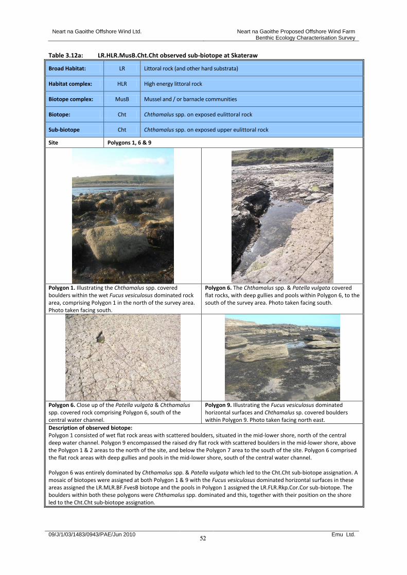
Neart na Gaoithe Offshore Wind Ltd. Neart na Gaoithe Proposed Offshore Wind Farm Benthic Ecology Characterisation Survey
09/J/1/03/1483/0943/PAE/Jun 2010 Emu Ltd.
52
Table 3.12a: LR.HLR.MusB.Cht.Cht observed sub-biotope at Skateraw
Broad Habitat: LR Littoral rock (and other hard substrata)
Habitat complex: HLR High energy littoral rock
Biotope complex: MusB Mussel and / or barnacle communities
Biotope: Cht Chthamalus spp. on exposed eulittoral rock
Sub-biotope Cht Chthamalus spp. on exposed upper eulittoral rock
Site Polygons 1, 6 & 9
Polygon 1. Illustrating the Chthamalus spp. covered boulders within the wet Fucus vesiculosus dominated rock area, comprising Polygon 1 in the north of the survey area. Photo taken facing south.
Polygon 6. The Chthamalus spp. & Patella vulgata covered flat rocks, with deep gullies and pools within Polygon 6, to the south of the survey area. Photo taken facing south.
Polygon 6. Close up of the Patella vulgata & Chthamalus spp. covered rock comprising Polygon 6, south of the central water channel.
Polygon 9. Illustrating the Fucus vesiculosus dominated horizontal surfaces and Chthamalus sp. covered boulders within Polygon 9. Photo taken facing north east.
Description of observed biotope: Polygon 1 consisted of wet flat rock areas with scattered boulders, situated in the mid-lower shore, north of the central deep water channel. Polygon 9 encompassed the raised dry flat rock with scattered boulders in the mid-lower shore, above the Polygon 1 & 2 areas to the north of the site, and below the Polygon 7 area to the south of the site. Polygon 6 comprised the flat rock areas with deep gullies and pools in the mid-lower shore, south of the central water channel. Polygon 6 was entirely dominated by Chthamalus spp. & Patella vulgata which led to the Cht.Cht sub-biotope assignation. A mosaic of biotopes were assigned at both Polygon 1 & 9 with the Fucus vesiculosus dominated horizontal surfaces in these areas assigned the LR.MLR.BF.FvesB biotope and the pools in Polygon 1 assigned the LR.FLR.Rkp.Cor.Cor sub-biotope. The boulders within both these polygons were Chthamalus spp. dominated and this, together with their position on the shore led to the Cht.Cht sub-biotope assignation.
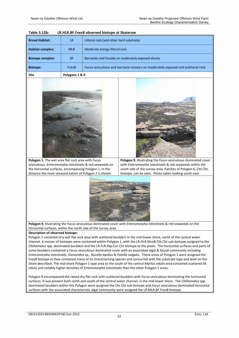
Neart na Gaoithe Offshore Wind Ltd. Neart na Gaoithe Proposed Offshore Wind Farm Benthic Ecology Characterisation Survey
09/J/1/03/1483/0943/PAE/Jun 2010 Emu Ltd.
53
Table 3.12b: LR.HLR.BF.FvesB observed biotope at Skateraw
Broad Habitat: LR Littoral rock (and other hard substrata)
Habitat complex: MLR Moderate energy littoral rock
Biotope complex: BF Barnacles and fucoids on moderately exposed shores
Biotope: FvesB Fucus vesiculosus and barnacle mosaics on moderately exposed mid eulittoral rock
Site Polygons 1 & 9
Polygon 1. The wet area flat rock area with Fucus vesiculosus, Enteromorpha intestinalis & red seaweeds on the horizontal surfaces, encompassing Polygon 1. In the distance the most seaward extent of Polygon 2 is shown.
Polygon 9. Illustrating the Fucus vesiculosus dominated cover with Enteromorpha intestinalis & red seaweeds within the south side of the survey area. Patches of Polygon 6, Cht.Cht, biotope, can be seen. Photo taken looking south east.
Polygon 9. Illustrating the Fucus vesiculosus dominated cover with Enteromorpha intestinalis & red seaweeds on the horizontal surfaces, within the north side of the survey area.
Description of observed biotope: Polygon 1 consisted of a wet flat rock area with scattered boulders in the mid-lower shore, north of the central water channel. A mosaic of biotopes were contained within Polygon 1, with the LR.HLR.MusB.Cht.Cht sub-biotope assigned to the Chthamalus spp. dominated boulders and the LR.FLR.Rkp.Cor.Cor biotope to the pools. The horizontal surfaces and parts of some boulders contained a Fucus vesiculosus dominated cover with an associated algal & faunal community including Enteromorpha intestinalis, Osmundea sp., Nucella lapillus & Patella vulgata. These areas of Polygon 1 were assigned the FvesB biotope as they contained many of its characterising species and concurred with the substrate type and level on the shore described. The mid shore Polygon 1 type area to the south of the central Mytilus edulis area contained scattered M. edulis and notably higher densities of Enteromorpha intestinalis than the other Polygon 1 areas. Polygon 9 encompassed the raised dry flat rock with scattered boulders with Fucus vesiculosus dominating the horizontal surfaces. It was present both north and south of the central water channel, in the mid-lower shore. The Chthamalus spp. dominated boulders within this Polygon were assigned the Cht.Cht sub-biotope and Fucus vesiculosus dominated horizontal surfaces with the associated characteristic algal community were assigned the LR.MLR.BF.FvesB biotope.

Neart na Gaoithe Offshore Wind Ltd. Neart na Gaoithe Proposed Offshore Wind Farm Benthic Ecology Characterisation Survey
09/J/1/03/1483/0943/PAE/Jun 2010 Emu Ltd.
54
Table 3.12c: LR.FLR.Rkp.Cor.Cor observed sub-biotope at Skateraw
Broad Habitat: LR Littoral rock (and other hard substrata)
Habitat complex: FLR Features of littoral rock
Biotope complex: Rkp Rockpools
Biotope: Cor Coralline crust-dominated shallow eulittoral pools
Sub-biotope Cor Coralline crusts and Corallina officinalis in shallow eulittoral rockpools
Site Polygon 1 & 1 ‘Lower’
Polygon 1. Close up of wet flat rock area comprising Polygon 1 in the north of the survey area.
Polygon 1. Example of a scattered boulder within Polygon 1 and the associated algal community on the wet horizontal surfaces.
Polygon 1 ‘Lower’. Illustrating the algal community within the pools in Polygon 1 ‘Lower’.
Polygon 1 ‘Lower’. Illustrating the boundary between Polygon 1 ‘Lower’ & Polygon 2 in the distance. Photo taken facing west.
Description of observed biotope: Polygon 1 consisted of wet flat rock areas with scattered boulders and rock pools. Polygon 1 ‘Lower’ was situated lower down in the shore & was similar to Polygon 1 except for the increase in both Cladophora sp. cover & the abundance of rock pools. The Coralline crusts and Corallina officinalis in shallow eulittoral rockpools sub-biotope, Cor.Cor, was assigned to the rock pools in both areas as they were dominated by Coralline crusts and erect forms and contained many of the other characterising species of this biotope. Additional characterising species included Cladophora spp., Littorina littorea & Patella vulgata. A mosaic of biotopes were assigned at Polygon 1 with LR.HLR.MusB.Cht.Cht allocated for the boulder communities & LR.MLR.BF.FvesB assigned for the Fucus vesiculosus dominated community primarily covering the horizontal surfaces.
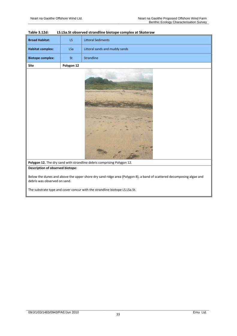
Neart na Gaoithe Offshore Wind Ltd. Neart na Gaoithe Proposed Offshore Wind Farm Benthic Ecology Characterisation Survey
09/J/1/03/1483/0943/PAE/Jun 2010 Emu Ltd.
55
Table 3.12d: LS.LSa.St observed strandline biotope complex at Skateraw
Broad Habitat: LS Littoral Sediments
Habitat complex: LSa Littoral sands and muddy sands
Biotope complex: St Strandline
Site Polygon 12
Polygon 12. The dry sand with strandline debris comprising Polygon 12.
Description of observed biotope: Below the dunes and above the upper shore dry sand ridge area (Polygon 8), a band of scattered decomposing algae and debris was observed on sand. The substrate type and cover concur with the strandline biotope LS.LSa.St.

Neart na Gaoithe Offshore Wind Ltd. Neart na Gaoithe Proposed Offshore Wind Farm Benthic Ecology Characterisation Survey
09/J/1/03/1483/0943/PAE/Jun 2010 Emu Ltd.
56
Table 3.12e: LR.MLR.BF.FSer observed biotope at Skateraw
Broad Habitat: LR Littoral rock (and other hard substrata)
Habitat complex: MLR Moderate energy littoral rock
Biotope complex: BF Barnacles and fucoids on moderately exposed shores
Biotope: FSer Fucus serratus on moderately exposed lower eulittoral rock
Site Polygon 2 & SK4
Polygon 2. Fucus serratus zone, comprising Polygon 2, bordering the Laminaria digitata zone, Polygon 3, in the northern side of the survey area. Photo taken facing east.
Polygon 2. The raised dry rock platform with Fucus serratus dominated cover comprising Polygon 2, bordered either side with Polygon 1 wet areas. Photo taken within the northern side of the survey area, facing west.
Polygon 2. Close up of the characteristic Fucus serratus & red algae mix comprising the Polygon 2 biotope type.
SK4. The complex patchy cover in the southern side of the survey area, encompassing Fucus serratus dominated cover, Enteromorpha / Ulva cover and areas with thin layers of sand on rock (SK2).
Description of observed biotope: Polygon 2 consisted of raised dry flat rock with Fucus serratus dominated cover in the lower shore, primarily in the north side of the site but with a small area south of the water channel. SK4, within the lower shore in the southern end of the survey area, contained patches of F. serratus dominated small boulder outcrops interspersed with patches of Ulva spp. / Enteromorpha intestinalis covered rock. The patches were so numerous and complex that they could not be individually delineated therefore a biotope mosaic has been assigned to this area, consisting of LR.MLR.BF.Fser & LR.FLR.Eph. Within this area patches of rock covered in a thin layer of sand were delineated (SK2 – LS.LSa.MoSa.BarSa). The substrate type, location on the shore, dominance of F. serratus and occurrence of additional characterising fauna including Chondrus crispus, Patella vulgata, Nucella lapillus & Corallinaceae all led to the assignation of the BF.Fser biotope.
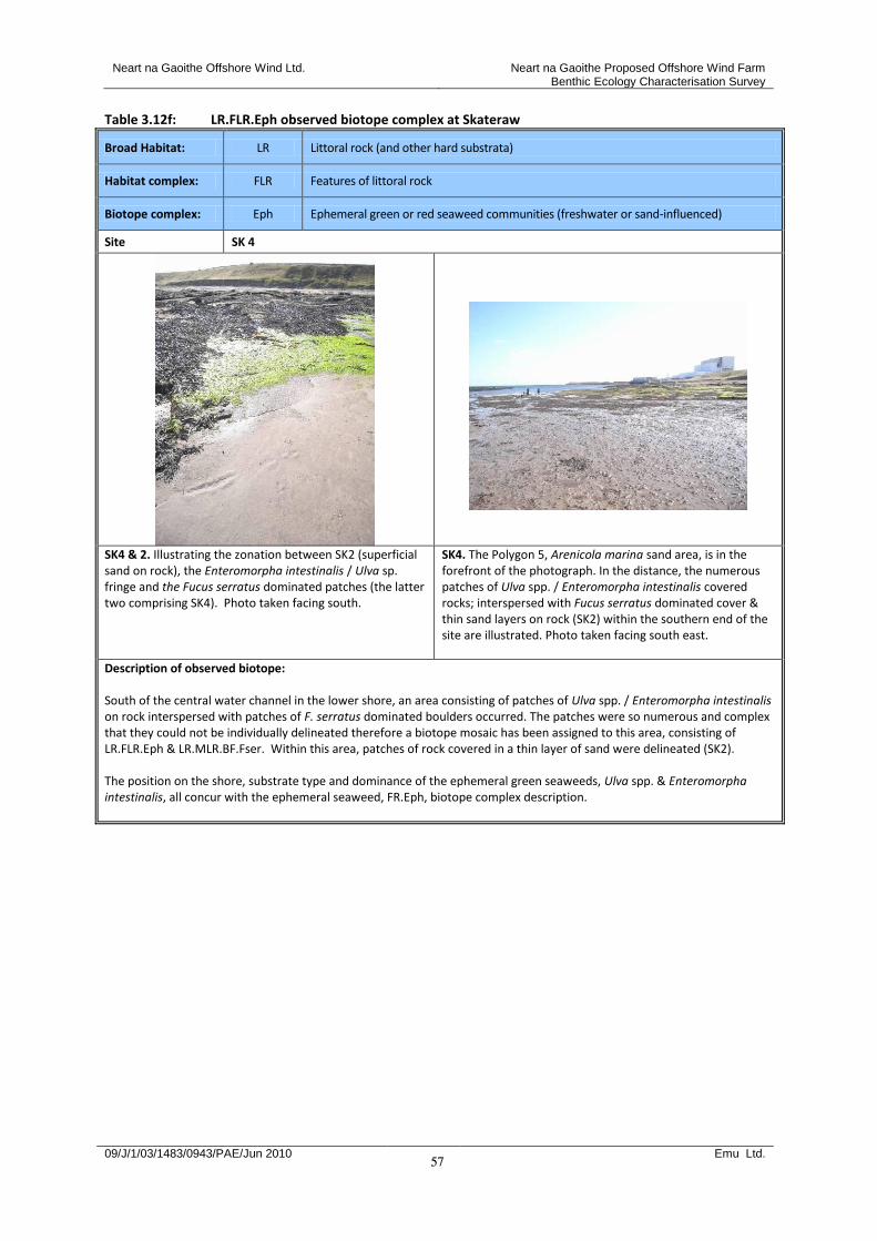
Neart na Gaoithe Offshore Wind Ltd. Neart na Gaoithe Proposed Offshore Wind Farm Benthic Ecology Characterisation Survey
09/J/1/03/1483/0943/PAE/Jun 2010 Emu Ltd.
57
Table 3.12f: LR.FLR.Eph observed biotope complex at Skateraw
Broad Habitat: LR Littoral rock (and other hard substrata)
Habitat complex: FLR Features of littoral rock
Biotope complex: Eph Ephemeral green or red seaweed communities (freshwater or sand-influenced)
Site SK 4
SK4 & 2. Illustrating the zonation between SK2 (superficial sand on rock), the Enteromorpha intestinalis / Ulva sp. fringe and the Fucus serratus dominated patches (the latter two comprising SK4). Photo taken facing south.
SK4. The Polygon 5, Arenicola marina sand area, is in the forefront of the photograph. In the distance, the numerous patches of Ulva spp. / Enteromorpha intestinalis covered rocks; interspersed with Fucus serratus dominated cover & thin sand layers on rock (SK2) within the southern end of the site are illustrated. Photo taken facing south east.
Description of observed biotope: South of the central water channel in the lower shore, an area consisting of patches of Ulva spp. / Enteromorpha intestinalis on rock interspersed with patches of F. serratus dominated boulders occurred. The patches were so numerous and complex that they could not be individually delineated therefore a biotope mosaic has been assigned to this area, consisting of LR.FLR.Eph & LR.MLR.BF.Fser. Within this area, patches of rock covered in a thin layer of sand were delineated (SK2). The position on the shore, substrate type and dominance of the ephemeral green seaweeds, Ulva spp. & Enteromorpha intestinalis, all concur with the ephemeral seaweed, FR.Eph, biotope complex description.
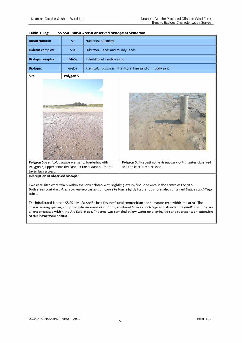
Neart na Gaoithe Offshore Wind Ltd. Neart na Gaoithe Proposed Offshore Wind Farm Benthic Ecology Characterisation Survey
09/J/1/03/1483/0943/PAE/Jun 2010 Emu Ltd.
58
Table 3.12g: SS.SSA.IMuSa.AreISa observed biotope at Skateraw
Broad Habitat: SS Sublittoral sediment
Habitat complex: SSa Sublittoral sands and muddy sands
Biotope complex: IMuSa Infralittoral muddy sand
Biotope: ArelSa Arenicola marina in infralittoral fine sand or muddy sand
Site Polygon 5
Polygon 5 Arenicola marina wet sand, bordering with Polygon 8, upper shore dry sand, in the distance. Photo taken facing west.
Polygon 5. Illustrating the Arenicola marina castes observed and the core sampler used.
Description of observed biotope: Two core sites were taken within the lower shore, wet, slightly gravelly, fine sand area in the centre of the site. Both areas contained Arenicola marina castes but, core site four, slightly further up shore, also contained Lanice conchilega tubes. The infralittoral biotope SS.SSa.IMuSa.ArelSa best fits the faunal composition and substrate type within the area. The characterising species, comprising dense Arenicola marina, scattered Lanice conchilega and abundant Capitella capitata, are all encompassed within the ArelSa biotope. The area was sampled at low water on a spring tide and represents an extension of this infralittoral habitat.
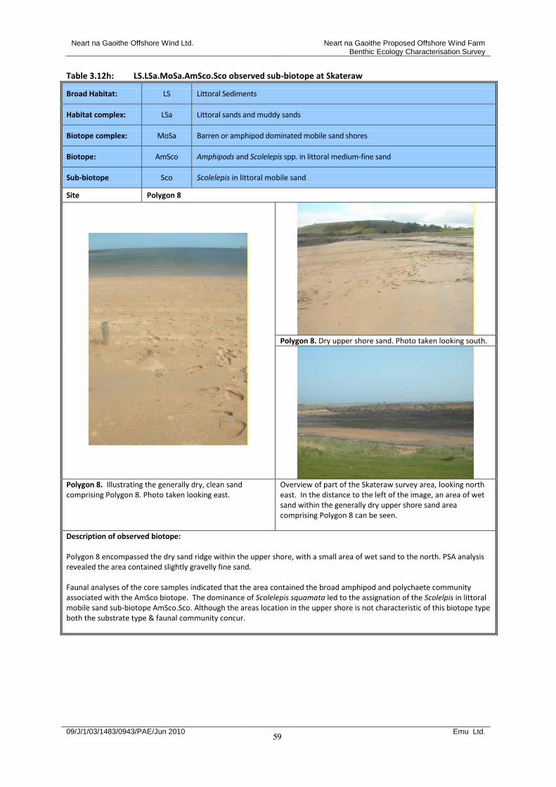
Neart na Gaoithe Offshore Wind Ltd. Neart na Gaoithe Proposed Offshore Wind Farm Benthic Ecology Characterisation Survey
09/J/1/03/1483/0943/PAE/Jun 2010 Emu Ltd.
59
Table 3.12h: LS.LSa.MoSa.AmSco.Sco observed sub-biotope at Skateraw
Broad Habitat: LS Littoral Sediments
Habitat complex: LSa Littoral sands and muddy sands
Biotope complex: MoSa Barren or amphipod dominated mobile sand shores
Biotope: AmSco Amphipods and Scolelepis spp. in littoral medium-fine sand
Sub-biotope Sco Scolelepis in littoral mobile sand
Site Polygon 8
Polygon 8. Dry upper shore sand. Photo taken looking south.
Polygon 8. Illustrating the generally dry, clean sand comprising Polygon 8. Photo taken looking east.
Overview of part of the Skateraw survey area, looking north east. In the distance to the left of the image, an area of wet sand within the generally dry upper shore sand area comprising Polygon 8 can be seen.
Description of observed biotope: Polygon 8 encompassed the dry sand ridge within the upper shore, with a small area of wet sand to the north. PSA analysis revealed the area contained slightly gravelly fine sand. Faunal analyses of the core samples indicated that the area contained the broad amphipod and polychaete community associated with the AmSco biotope. The dominance of Scolelepis squamata led to the assignation of the Scolelpis in littoral mobile sand sub-biotope AmSco.Sco. Although the areas location in the upper shore is not characteristic of this biotope type both the substrate type & faunal community concur.
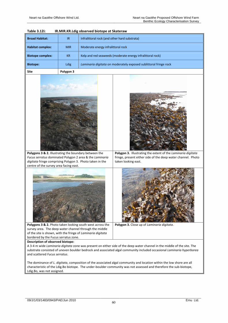
Neart na Gaoithe Offshore Wind Ltd. Neart na Gaoithe Proposed Offshore Wind Farm Benthic Ecology Characterisation Survey
09/J/1/03/1483/0943/PAE/Jun 2010 Emu Ltd.
60
Table 3.12i: IR.MIR.KR.Ldig observed biotope at Skateraw
Broad Habitat: IR Infralittoral rock (and other hard substrata)
Habitat complex: MIR Moderate energy infralittoral rock
Biotope complex: KR Kelp and red seaweeds (moderate energy infralittoral rock)
Biotope: Ldig Laminaria digitata on moderately exposed sublittoral fringe rock
Site Polygon 3
Polygons 3 & 2. Illustrating the boundary between the Fucus serratus dominated Polygon 2 area & the Laminaria digitata fringe comprising Polygon 3. Photo taken in the centre of the survey area facing east.
Polygon 3. Illustrating the extent of the Laminaria digitata fringe, present either side of the deep water channel. Photo taken looking east.
Polygons 3 & 2. Photo taken looking south west across the survey area. The deep water channel through the middle of the site is shown, with the fringe of Laminaria digitata bordered by the Fucus serratus zone.
Polygon 3. Close up of Laminaria digitata.
Description of observed biotope: A 3-4 m wide Laminaria digitata zone was present on either side of the deep water channel in the middle of the site. The substrate consisted of uneven boulder bedrock and associated algal community included occasional Laminaria hyperborea and scattered Fucus serratus. The dominance of L. digitata, composition of the associated algal community and location within the low shore are all characteristic of the Ldig.Bo biotope. The under-boulder community was not assessed and therefore the sub-biotope, Ldig.Bo, was not assigned.

Neart na Gaoithe Offshore Wind Ltd. Neart na Gaoithe Proposed Offshore Wind Farm Benthic Ecology Characterisation Survey
09/J/1/03/1483/0943/PAE/Jun 2010 Emu Ltd.
61
Table 3.12j: IR.MIR.KR.LhypTX observed biotope at Skateraw
Broad Habitat: IR Infralittoral rock (and other hard substrata)
Habitat complex: MIR Moderate energy infralittoral rock
Biotope complex: KR Kelp and red seaweeds (moderate energy infralittoral rock)
Biotope: LhypTX Laminaria hyperborea on tide-swept infralittoral mixed substrata
Site Polygon 10
Polygon 10. The characteristic upright form of Laminaria hyperborea, within the deep water channel through the site. Photo taken looking west across the survey area.
Polygon 10. Laminaria hyperborea to the south of the survey area.
Description of observed biotope: Laminaria hyperborea covered boulders/cobbles/pebbles within the deep water channel through the middle of the survey area were assigned the ‘Laminaria hyperborea on tide-swept infralittoral mixed substrata’, IR.MIR.KR.LhypTX, biotope. The substrate type, position within the infralittoral and dominance of L.hyperborea all concur with the LhypTX description.
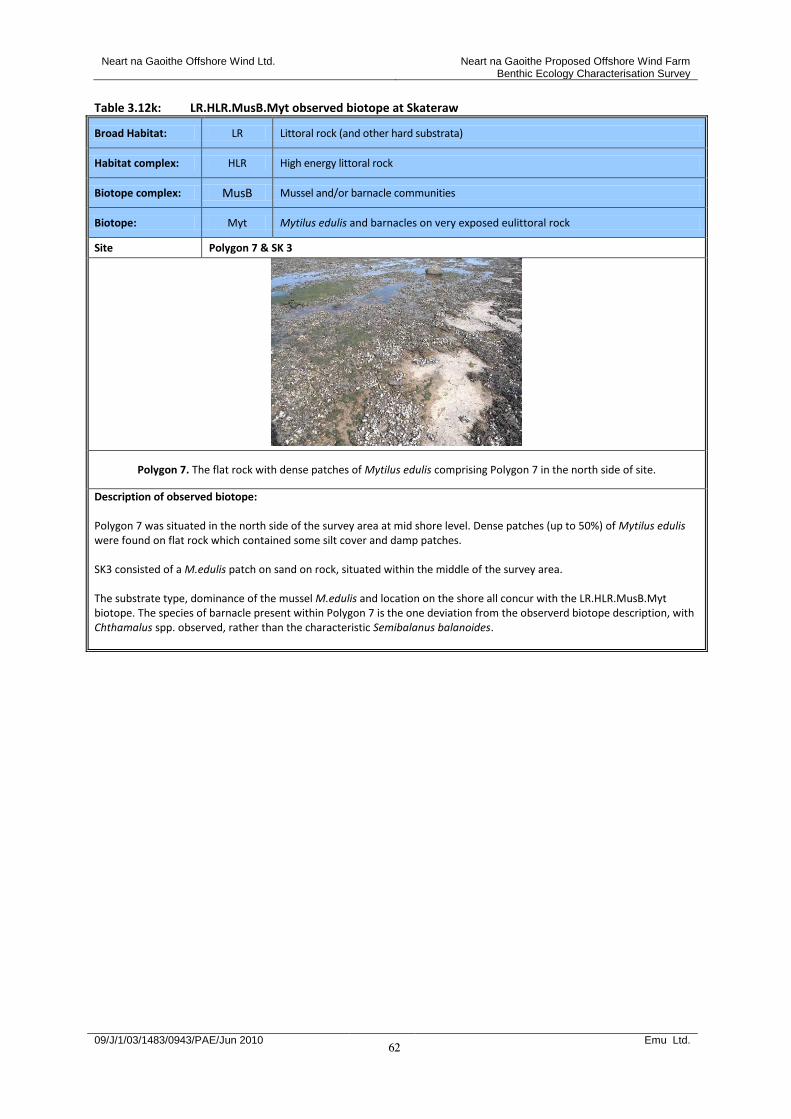
Neart na Gaoithe Offshore Wind Ltd. Neart na Gaoithe Proposed Offshore Wind Farm Benthic Ecology Characterisation Survey
09/J/1/03/1483/0943/PAE/Jun 2010 Emu Ltd.
62
Table 3.12k: LR.HLR.MusB.Myt observed biotope at Skateraw
Broad Habitat: LR Littoral rock (and other hard substrata)
Habitat complex: HLR High energy littoral rock
Biotope complex: MusB Mussel and/or barnacle communities
Biotope: Myt Mytilus edulis and barnacles on very exposed eulittoral rock
Site Polygon 7 & SK 3
Polygon 7. The flat rock with dense patches of Mytilus edulis comprising Polygon 7 in the north side of site.
Description of observed biotope: Polygon 7 was situated in the north side of the survey area at mid shore level. Dense patches (up to 50%) of Mytilus edulis were found on flat rock which contained some silt cover and damp patches. SK3 consisted of a M.edulis patch on sand on rock, situated within the middle of the survey area. The substrate type, dominance of the mussel M.edulis and location on the shore all concur with the LR.HLR.MusB.Myt biotope. The species of barnacle present within Polygon 7 is the one deviation from the observerd biotope description, with Chthamalus spp. observed, rather than the characteristic Semibalanus balanoides.

Neart na Gaoithe Offshore Wind Ltd. Neart na Gaoithe Proposed Offshore Wind Farm Benthic Ecology Characterisation Survey
09/J/1/03/1483/0943/PAE/Jun 2010 Emu Ltd.
63
Table 3.12l: LS.LBR.LMus.Myt.Mx observed sub-biotope at Skateraw
Broad Habitat: LS Littoral sediment
Habitat complex: LBR Littoral biogenic reefs
Biotope complex: LMus Littoral mussel beds on sediment
Biotope: Myt Mytilus edulis beds on littoral sediments
Sub-biotope: Mx Mytilus edulis beds on littoral mixed substrata
Site Polygon 7 & SK 3
Polygon 7. The uneven rock with cobbles/pebbles/gravel and patchy Mytilus edulis, comprising Polygon 7 in the south side of site.
Description of observed biotope: Polygon 14 was located within the south side of the site within the mid-lower shore, on very uneven rock, with 60% cobbles/gravel/pebbles, & ridges present. Dense patches (up to 40%) of Mytilus edulis were found. The pebble/cobble/gravel substrate, dominance of M. edulis & position on the shore all concur with the LS.LBR.LMus.Myt.Mx biotope.
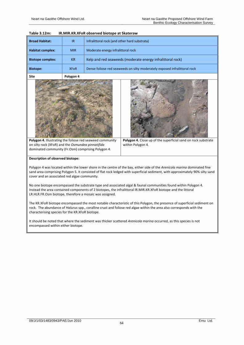
Neart na Gaoithe Offshore Wind Ltd. Neart na Gaoithe Proposed Offshore Wind Farm Benthic Ecology Characterisation Survey
09/J/1/03/1483/0943/PAE/Jun 2010 Emu Ltd.
64
Table 3.12m: IR.MIR.KR.XFoR observed biotope at Skateraw
Broad Habitat: IR Infralittoral rock (and other hard substrata)
Habitat complex: MIR Moderate energy infralittoral rock
Biotope complex: KR Kelp and red seaweeds (moderate energy infralittoral rock)
Biotope: XFoR Dense foliose red seaweeds on silty moderately exposed infralittoral rock
Site Polygon 4
Polygon 4. Illustrating the foliose red seaweed community on silty rock (XFoR) and the Osmundea pinnatifida dominated community (Fr.Osm) comprising Polygon 4.
Polygon 4. Close up of the superficial sand on rock substrate within Polygon 4.
Description of observed biotope: Polygon 4 was located within the lower shore in the centre of the bay, either side of the Arenicola marina dominated fine sand area comprising Polygon 5. It consisted of flat rock ledged with superficial sediment, with approximately 90% silty sand cover and an associated red algae community. No one biotope encompassed the substrate type and associated algal & faunal communities found within Polygon 4. Instead the area contained components of 2 biotopes, the infralittoral IR.MIR.KR.XFoR biotope and the littoral LR.HLR.FR.Osm biotope, therefore a mosaic was assigned. The KR.XFoR biotope encompassed the most notable characteristic of this Polygon, the presence of superficial sediment on rock. The abundance of Halurus spp., coralline crust and foliose red algae within the area also corresponds with the characterising species for the KR.XFoR biotope. It should be noted that where the sediment was thicker scattered Arenicola marina occurred, as this species is not encompassed within either biotope.

Neart na Gaoithe Offshore Wind Ltd. Neart na Gaoithe Proposed Offshore Wind Farm Benthic Ecology Characterisation Survey
09/J/1/03/1483/0943/PAE/Jun 2010 Emu Ltd.
65
Table 3.12n: LR.HLR.FR.Osm observed biotope at Skateraw
Broad Habitat: LR Littoral rock (and other hard substrata)
Habitat complex: HLR High energy littoral rock
Biotope complex: FR Robust fucoid and/or red seaweed communities
Biotope: Osm Osmundea pinnatifida on moderately exposed mid eulittoral rock
Site Polygon 4
Polygon 4. Illustrating extent of Polygon 4 area to the south of the shore and the associated algal community, including the Osmundea pinnatifida dominated community (Fr.Osm). Photo taken facing west.
Polygon 4. Illustrating the Osmundea pinnatifida dominated community (Fr.Osm) and foliose red algae community (XFoR) comprising Polygon 4.
Description of observed biotope: Polygon 4 was located within the lower shore in the centre of the bay, either side of the Arenicola marina dominated fine sand area comprising Polygon 5. It consisted of flat rock ledged with superficial sediment, with approximately 90% silty sand cover and an associated red algae community. No one biotope encompassed the substrate type and associated algal and faunal communities found within Polygon 4. Instead the area contained components of 2 biotopes, the littoral LR.HLR.FR.Osm biotope & the infralittoral IR.MIR.KR.XFoR biotope, therefore a mosaic was assigned. Within the lower shore, where there was most silt, 60% Osmudea pinnatifida cover was observed. The LR.HLR.FR.Osm biotope encompasses the abundance of Osmudea pinnatifida within Polygon 4 and also concurs with the location on the shore and the substrate type within the area.
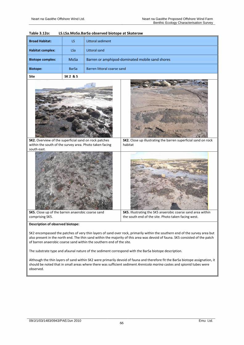
Neart na Gaoithe Offshore Wind Ltd. Neart na Gaoithe Proposed Offshore Wind Farm Benthic Ecology Characterisation Survey
09/J/1/03/1483/0943/PAE/Jun 2010 Emu Ltd.
66
Table 3.12o: LS.LSa.MoSa.BarSa observed biotope at Skateraw
Broad Habitat: LS Littoral sediment
Habitat complex: LSa Littoral sand
Biotope complex: MoSa Barren or amphipod-dominated mobile sand shores
Biotope: BarSa Barren littoral coarse sand
Site SK 2 & 5
SK2. Overview of the superficial sand on rock patches within the south of the survey area. Photo taken facing south east.
SK2. Close up illustrating the barren superficial sand on rock habitat
SK5. Close up of the barren anaerobic coarse sand comprising SK5.
SK5. Illustrating the SK5 anaerobic coarse sand area within the south end of the site. Photo taken facing west.
Description of observed biotope: SK2 encompassed the patches of very thin layers of sand over rock, primarily within the southern end of the survey area but also present in the north end. The thin sand within the majority of this area was devoid of fauna. SK5 consisted of the patch of barren anaerobic coarse sand within the southern end of the site. The substrate type and afaunal nature of the sediment correspond with the BarSa biotope description. Although the thin layers of sand within SK2 were primarily devoid of fauna and therefore fit the BarSa biotope assignation, it should be noted that in small areas where there was sufficient sediment Arenicola marina castes and spionid tubes were observed.
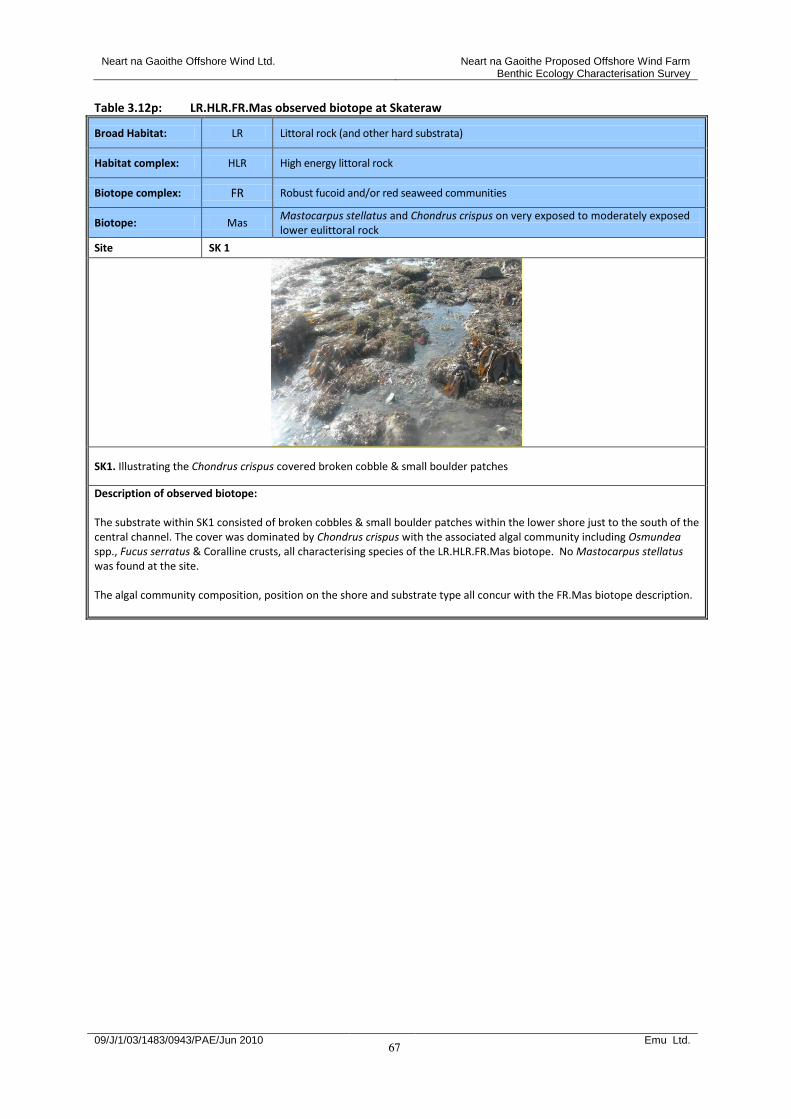
Neart na Gaoithe Offshore Wind Ltd. Neart na Gaoithe Proposed Offshore Wind Farm Benthic Ecology Characterisation Survey
09/J/1/03/1483/0943/PAE/Jun 2010 Emu Ltd.
67
Table 3.12p: LR.HLR.FR.Mas observed biotope at Skateraw
Broad Habitat: LR Littoral rock (and other hard substrata)
Habitat complex: HLR High energy littoral rock
Biotope complex: FR Robust fucoid and/or red seaweed communities
Biotope: Mas Mastocarpus stellatus and Chondrus crispus on very exposed to moderately exposed lower eulittoral rock
Site SK 1
SK1. Illustrating the Chondrus crispus covered broken cobble & small boulder patches
Description of observed biotope: The substrate within SK1 consisted of broken cobbles & small boulder patches within the lower shore just to the south of the central channel. The cover was dominated by Chondrus crispus with the associated algal community including Osmundea spp., Fucus serratus & Coralline crusts, all characterising species of the LR.HLR.FR.Mas biotope. No Mastocarpus stellatus was found at the site. The algal community composition, position on the shore and substrate type all concur with the FR.Mas biotope description.
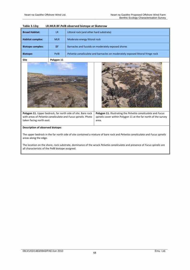
Neart na Gaoithe Offshore Wind Ltd. Neart na Gaoithe Proposed Offshore Wind Farm Benthic Ecology Characterisation Survey
09/J/1/03/1483/0943/PAE/Jun 2010 Emu Ltd.
68
Table 3.12q: LR.MLR.BF.PelB observed biotope at Skateraw
Broad Habitat: LR Littoral rock (and other hard substrata)
Habitat complex: MLR Moderate energy littoral rock
Biotope complex: BF Barnacles and fucoids on moderately exposed shores
Biotope: PelB Pelvetia canaliculata and barnacles on moderately exposed littoral fringe rock
Site Polygon 11
Polygon 11. Upper bedrock, far north side of site. Bare rock with areas of Pelvetia canaliculata and Fucus spiralis. Photo taken facing north east.
Polygon 11. Illustrating the Pelvetia canaliculata and Fucus spiralis cover within Polygon 11 at the far north of the survey area.
Description of observed biotope: The upper bedrock in the far north side of site contained a mixture of bare rock and Pelvetia canaliculata and Fucus spiralis areas along the edge. The location on the shore, rock substrate, dominance of the wrack Pelvetia canaliculata and presence of Fucus spiralis are all characteristic of the PelB biotope assigned.
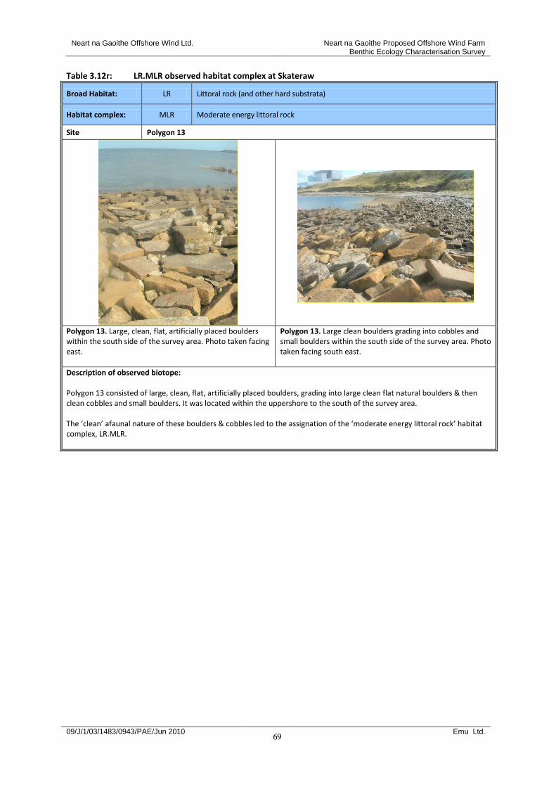
Neart na Gaoithe Offshore Wind Ltd. Neart na Gaoithe Proposed Offshore Wind Farm Benthic Ecology Characterisation Survey
09/J/1/03/1483/0943/PAE/Jun 2010 Emu Ltd.
69
Table 3.12r: LR.MLR observed habitat complex at Skateraw
Broad Habitat: LR Littoral rock (and other hard substrata)
Habitat complex: MLR Moderate energy littoral rock
Site Polygon 13
Polygon 13. Large, clean, flat, artificially placed boulders within the south side of the survey area. Photo taken facing east.
Polygon 13. Large clean boulders grading into cobbles and small boulders within the south side of the survey area. Photo taken facing south east.
Description of observed biotope: Polygon 13 consisted of large, clean, flat, artificially placed boulders, grading into large clean flat natural boulders & then clean cobbles and small boulders. It was located within the uppershore to the south of the survey area. The ‘clean’ afaunal nature of these boulders & cobbles led to the assignation of the ‘moderate energy littoral rock’ habitat complex, LR.MLR.

Neart na Gaoithe Offshore Wind Ltd. Neart na Gaoithe Proposed Offshore Wind Farm Benthic Ecology Characterisation Survey
09/J/1/03/1483/0943/PAE/Jun 2010 Emu Ltd.
70
Table 3.12s: Observed ridge feature at Skateraw
Feature: Ridge, south side of the survey area
Description A long ridge dissected part of the southern end of the survey area. The vertical face of the ridge was dominated by Chthamalus spp. and therefore consists of the LR.HLR.MusB.Cht.Cht sub-biotope found elsewhere in the survey area. Along the top of the ridge an algal fringe, dominated by Fucus vesiculosus, was present.
Biotope distribution at Skateraw 3.32 A total of 78 species were found in the intertidal survey at Skateraw. See Appendix X for a full list of
species. Appendix XI contains the field descriptions of all the polygons and target notes observed at Skateraw.
3.33 Skateraw was the most biologically diverse area (in terms of numbers of biotopes present) out of the 3
potential cable landfall sites surveyed. The area consisted of a high energy sandy beach with extensive areas of bedrock. A deep water channel dissected the site, within which Laminaria hyperborea dominated, IR.MIR.KR.LhypTx, cover was observed with a Laminaria digitata fringe, IR.MIR.KR.Ldig, abutting the bedrock areas.
3.34 Uneven cobbles/pebbles/gravel areas were present to the south of the channel, overlying bedrock.
Artificially placed large clean boulders were located within the upper shore to the south of the site, grading into clean small boulders/cobbles, LR.MLR. Interesting features included the ‘natural’ large, erratic boulders, particularly in the north of the site; the superficial sand on rock areas with an associated red algae community either side of the Arenicola/Lanice sand area; and the numerous patches of rock overlain with a thin layer of barren sand south of the central water channel.
3.35 Skateraw contained biotopes indicative of a high level of wave exposure. Sandy embayments in the
upper shore contained barren sand with strandline debris, LS.LSa.St. Below this, mobile species-poor sand, dominated by the polychaete Scolelepis spp., LS.LSa.MoSa.AmSco.Sco, was present inthe mid shore. In the lower shore, clean sand with Arenicola and scattered Lanice conchilega occurred, SS.SSa.IMuSa.ArelSa.
Neart na Gaoithe Offshore Wind Ltd. Neart na Gaoithe Proposed Offshore Wind Farm Benthic Ecology Characterisation Survey
09/J/1/03/1483/0943/PAE/Jun 2010 Emu Ltd.
71
3.36 The rocky habitats at Skateraw were very complex. Over much of the shore the rock was broken into various heights from the upper shore to the lower shore, with upper shore biotopes on the top of promontories. Pools, bedrock ridges and erratic boulders were present, resulting in the occurrence of a complex mosaic of biotopes in a small area, which made biotope mapping difficult.
3.37 A broad lower to upper shore zonation pattern could be seen from the central deep water channel up
to the land, on both the north and south sides of the channel. On the north side of the channel, the upper shore area consisted of raised bare bedrock with patches of typical upper shore algal species, Pelvetia canaliculata and Fucus spiralis, LR.MLR.BF.PelB. Below this area the horizontal surfaces were covered by Fucus vesiculosus dominated communities, LR.MLR.BFFvesB, on both the raised dry rock and the wet rock areas. Fucus serratus dominated communities, LR.MLR.BF.Fser, were nearest to the deep water channel, adjacent to the Laminaria digitata zone in the sublittoral fringe. The Fucus serratus dominated area was dissected by a wet area with a concentration of pools, LR.FLR.Rkp.Cor.Cor.
3.38 Within the area north of the channel, ridges of raised dry bedrock were interspersed with lower wet
areas with numerous pools containing abundant coralline crusts and erect forms, LR.FLR.Rkp.Cor.Cor. The scattered erratic boulders within this area contained the characteristic upper shore barnacle and limpet dominated biotope typical of more exposed shores, LR.HLR.MusB.Cht.Cht.
3.39 Enteromorpha intestinalis and Ulva spp. were present throughout the fucoid zone in the north of the
site but its density noticeably increased in the areas abutting the Mytilus edulis dominated area north of the channel. Large expanses of sand surrounded this area and it is possible that the increase in ephemeral alga is linked to the increase in sand scour in these border areas.
3.40 The large area of mussels on bedrock present to the north of the channel was assigned the
LR.HLR.MusB.MytB. Adjacent to this, an area of rock overlain with superficial sediment and with an associated red algae community, mosaic: LR.HLR.FR.Osm & IR.MIR.KR.XFoR, occurred on either side of the lower shore Arenicola / Lanice sand area.
3.41 The typical fucoid zonation from the water channel to the upper shore, also occurred on the south
side of the site. A Fucus serratus zone was present fringing the water channel. Within this area a discrete Chondrus crispus zone was present, LR.HLR.FR.Mas. Landward, the Fucus serratus zone merged into a complex mosaic of biotopes. The different biotope patches were so numerous and complex that they could not be individually delineated and so a biotope mosaic was assigned to the area consisting of the Fucus serratus dominated biotope, LR.MLR.BF.Fser; the ephemeral algae biotope, LR.FLR.Eph, for the Ulva/Enteromorpha dominated patches; and LS.LSa.MoSa.BarSa for the areas of rock overlain with a thin layer of barren sand which were interspersed within the area.
3.42 Above this complex area a Fucus vesiculosus dominated zone, LR.MLR.BF.FvesB, interspersed with
areas of rock with deep gullies and pools dominated by Chthalamus spp. and Patella vulgata, LR.HLR.MusB.Cht.Cht, was present. Either side of the ridge in the south side of site, a large Mytilus edulis area on broken cobbles, pebbles and gravel, LS.LBR.LMus.Myt.Mx, dissected the barnacle dominated area.
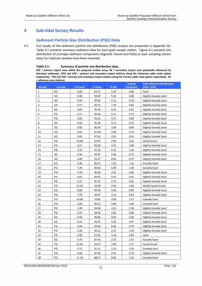
Neart na Gaoithe Offshore Wind Ltd. Neart na Gaoithe Proposed Offshore Wind Farm Benthic Ecology Characterisation Survey
09/J/1/03/1483/0943/PAE/Jun 2010 Emu Ltd.
72
4 Sub-tidal Survey Results
Sediment Particle Size Distribution (PSD) Data 4.1 Full results of the sediment particle size distribution (PSD) analysis are presented in Appendix XII.
Table 4.1 presents summary sediment data for each grab sample station. Figure 4.1 presents the distribution of principal sediment components (%gravel, %sand and %silt) at each sampling station (data for triplicate samples have been meaned).
Table 4.1: Summary of particle size distribution data. (PIZ = primary impact zone within the proposed turbine array; SIZ = secondary impact zone potentially influenced by disturbed sediments. CPIZ and CSIZ = primary and secondary impact stations along the Cockenzie cable route option respectively. TPIZ and TSIZ = primary and secondary impact stations along the Torness cable route option respectively. RZ = reference zone stations).
Sample Location % Gravel: % Sand: % Silt: Sorting
Coefficient Folk sediment classification (Folk, 1954)
1 SIZ 0.00 94.71 5.29 0.66 Sand
2 SIZ 0.08 94.49 5.43 0.69 Slightly Gravelly Sand
3 SIZ 0.94 93.95 5.12 0.74 Slightly Gravelly Sand
4 SIZ 0.17 92.54 7.29 0.85 Slightly Gravelly Sand
5 SIZ 0.03 93.56 6.41 0.67 Slightly Gravelly Sand
6 PIZ 0.17 94.46 5.37 0.73 Slightly Gravelly Sand
7 PIZ 0.03 95.61 4.37 0.84 Slightly Gravelly Sand
8 SIZ 0.02 95.24 4.74 0.75 Slightly Gravelly Sand
9 SIZ 0.00 96.90 3.09 0.94 Slightly Gravelly Sand
10 SIZ 0.03 97.08 2.89 0.76 Slightly Gravelly Sand
11 SIZ 0.05 97.03 2.91 0.91 Slightly Gravelly Sand
12 PIZ 33.66 63.43 2.92 3.26 Sandy Gravel
13 PIZ 0.21 95.84 3.95 1.06 Slightly Gravelly Sand
14 PIZ 2.53 91.16 6.31 1.24 Slightly Gravelly Sand
15 SIZ 0.34 93.97 5.69 0.75 Slightly Gravelly Sand
16 SIZ 0.89 91.07 8.04 0.57 Slightly Gravelly Sand
17 SIZ 6.90 85.57 7.53 1.55 Gravelly Sand
18 PIZ 7.29 85.83 6.89 1.58 Gravelly Sand
19 PIZ 0.19 96.46 3.35 0.96 Slightly Gravelly Sand
20 PIZ 0.05 94.92 5.03 0.81 Slightly Gravelly Sand
21 PIZ 0.17 97.10 2.73 0.91 Slightly Gravelly Sand
22 PIZ 51.94 43.06 5.00 3.80 Muddy Sandy Gravel
23 SIZ 0.04 96.56 3.40 0.84 Slightly Gravelly Sand
24 PIZ 2.79 94.07 3.14 0.83 Slightly Gravelly Sand
25 PIZ 16.06 79.85 4.09 2.57 Gravelly Sand
26 PIZ 5.60 90.51 3.89 1.64 Gravelly Sand
27 PIZ 1.09 94.38 4.53 1.18 Slightly Gravelly Sand
28 PIZ 0.24 93.90 5.85 0.80 Slightly Gravelly Sand
29 SIZ 0.09 90.86 9.05 0.60 Slightly Gravelly Sand
30 SIZ 0.21 93.87 5.92 0.97 Slightly Gravelly Sand
31 PIZ 0.04 93.96 6.00 0.70 Slightly Gravelly Sand
32 PIZ 2.36 95.12 2.52 1.03 Slightly Gravelly Sand
33 PIZ 0.00 97.82 2.18 0.82 Sand
34 SIZ 9.79 87.45 2.75 1.67 Gravelly Sand
35 PIZ 41.63 56.37 2.00 2.71 Sandy Gravel
36 PIZ 6.75 91.11 2.14 1.35 Gravelly Sand
37 PIZ 0.00 97.48 2.52 0.75 Slightly Gravelly Sand
38 PIZ 11.34 88.57 0.08 1.56 Gravelly Sand
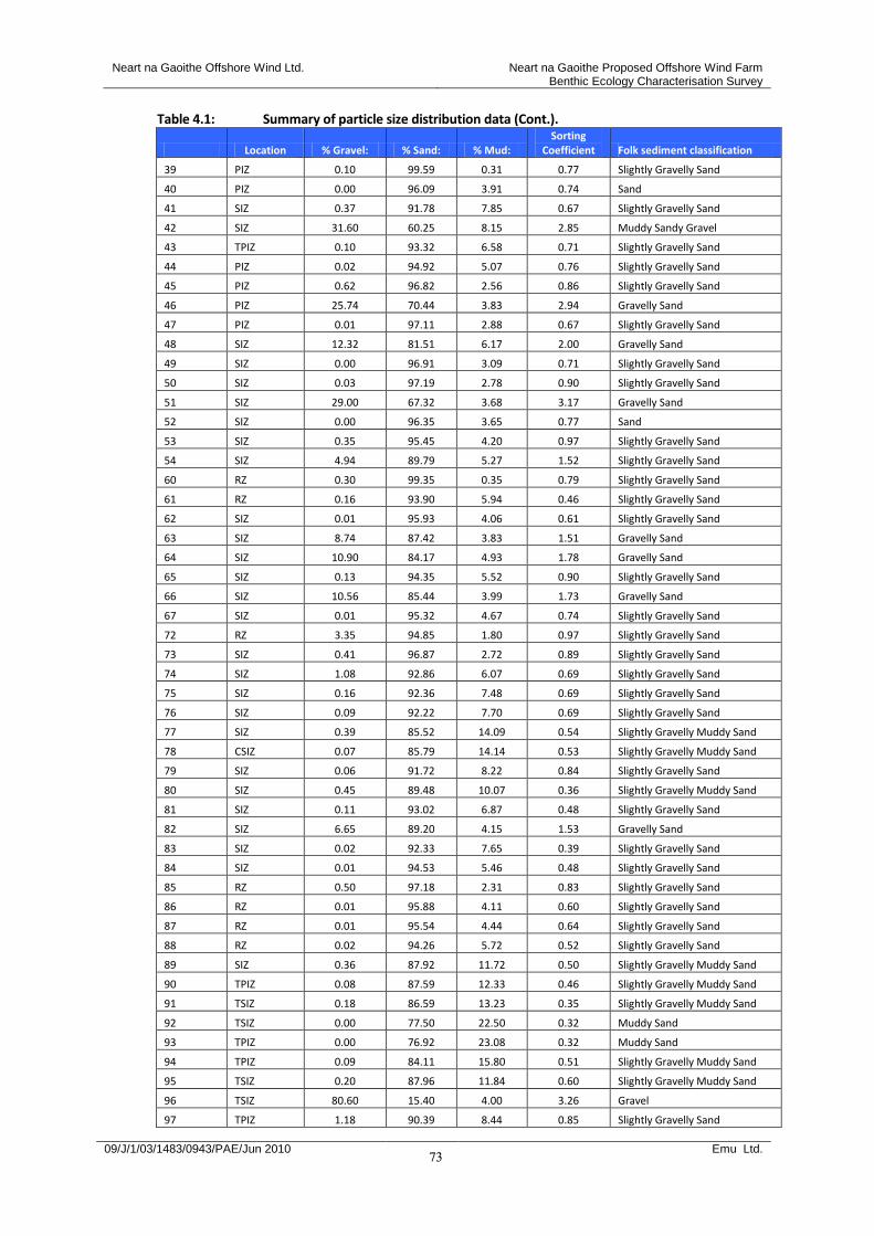
Neart na Gaoithe Offshore Wind Ltd. Neart na Gaoithe Proposed Offshore Wind Farm Benthic Ecology Characterisation Survey
09/J/1/03/1483/0943/PAE/Jun 2010 Emu Ltd.
73
Table 4.1: Summary of particle size distribution data (Cont.).
Location % Gravel: % Sand: % Mud: Sorting
Coefficient Folk sediment classification
39 PIZ 0.10 99.59 0.31 0.77 Slightly Gravelly Sand
40 PIZ 0.00 96.09 3.91 0.74 Sand
41 SIZ 0.37 91.78 7.85 0.67 Slightly Gravelly Sand
42 SIZ 31.60 60.25 8.15 2.85 Muddy Sandy Gravel
43 TPIZ 0.10 93.32 6.58 0.71 Slightly Gravelly Sand
44 PIZ 0.02 94.92 5.07 0.76 Slightly Gravelly Sand
45 PIZ 0.62 96.82 2.56 0.86 Slightly Gravelly Sand
46 PIZ 25.74 70.44 3.83 2.94 Gravelly Sand
47 PIZ 0.01 97.11 2.88 0.67 Slightly Gravelly Sand
48 SIZ 12.32 81.51 6.17 2.00 Gravelly Sand
49 SIZ 0.00 96.91 3.09 0.71 Slightly Gravelly Sand
50 SIZ 0.03 97.19 2.78 0.90 Slightly Gravelly Sand
51 SIZ 29.00 67.32 3.68 3.17 Gravelly Sand
52 SIZ 0.00 96.35 3.65 0.77 Sand
53 SIZ 0.35 95.45 4.20 0.97 Slightly Gravelly Sand
54 SIZ 4.94 89.79 5.27 1.52 Slightly Gravelly Sand
60 RZ 0.30 99.35 0.35 0.79 Slightly Gravelly Sand
61 RZ 0.16 93.90 5.94 0.46 Slightly Gravelly Sand
62 SIZ 0.01 95.93 4.06 0.61 Slightly Gravelly Sand
63 SIZ 8.74 87.42 3.83 1.51 Gravelly Sand
64 SIZ 10.90 84.17 4.93 1.78 Gravelly Sand
65 SIZ 0.13 94.35 5.52 0.90 Slightly Gravelly Sand
66 SIZ 10.56 85.44 3.99 1.73 Gravelly Sand
67 SIZ 0.01 95.32 4.67 0.74 Slightly Gravelly Sand
72 RZ 3.35 94.85 1.80 0.97 Slightly Gravelly Sand
73 SIZ 0.41 96.87 2.72 0.89 Slightly Gravelly Sand
74 SIZ 1.08 92.86 6.07 0.69 Slightly Gravelly Sand
75 SIZ 0.16 92.36 7.48 0.69 Slightly Gravelly Sand
76 SIZ 0.09 92.22 7.70 0.69 Slightly Gravelly Sand
77 SIZ 0.39 85.52 14.09 0.54 Slightly Gravelly Muddy Sand
78 CSIZ 0.07 85.79 14.14 0.53 Slightly Gravelly Muddy Sand
79 SIZ 0.06 91.72 8.22 0.84 Slightly Gravelly Sand
80 SIZ 0.45 89.48 10.07 0.36 Slightly Gravelly Muddy Sand
81 SIZ 0.11 93.02 6.87 0.48 Slightly Gravelly Sand
82 SIZ 6.65 89.20 4.15 1.53 Gravelly Sand
83 SIZ 0.02 92.33 7.65 0.39 Slightly Gravelly Sand
84 SIZ 0.01 94.53 5.46 0.48 Slightly Gravelly Sand
85 RZ 0.50 97.18 2.31 0.83 Slightly Gravelly Sand
86 RZ 0.01 95.88 4.11 0.60 Slightly Gravelly Sand
87 RZ 0.01 95.54 4.44 0.64 Slightly Gravelly Sand
88 RZ 0.02 94.26 5.72 0.52 Slightly Gravelly Sand
89 SIZ 0.36 87.92 11.72 0.50 Slightly Gravelly Muddy Sand
90 TPIZ 0.08 87.59 12.33 0.46 Slightly Gravelly Muddy Sand
91 TSIZ 0.18 86.59 13.23 0.35 Slightly Gravelly Muddy Sand
92 TSIZ 0.00 77.50 22.50 0.32 Muddy Sand
93 TPIZ 0.00 76.92 23.08 0.32 Muddy Sand
94 TPIZ 0.09 84.11 15.80 0.51 Slightly Gravelly Muddy Sand
95 TSIZ 0.20 87.96 11.84 0.60 Slightly Gravelly Muddy Sand
96 TSIZ 80.60 15.40 4.00 3.26 Gravel
97 TPIZ 1.18 90.39 8.44 0.85 Slightly Gravelly Sand
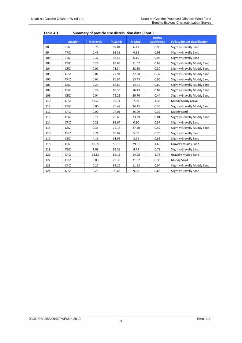
Neart na Gaoithe Offshore Wind Ltd. Neart na Gaoithe Proposed Offshore Wind Farm Benthic Ecology Characterisation Survey
09/J/1/03/1483/0943/PAE/Jun 2010 Emu Ltd.
74
Table 4.1: Summary of particle size distribution data (Cont.).
Location % Gravel: % Sand: % Mud: Sorting
Coefficient Folk sediment classification
98 TSIZ 0.76 92.81 6.43 0.95 Slightly Gravelly Sand
99 TPIZ 0.49 92.59 6.92 0.91 Slightly Gravelly Sand
100 TSIZ 0.31 93.53 6.16 0.98 Slightly Gravelly Sand
103 CSIZ 0.28 88.65 11.07 0.69 Slightly Gravelly Muddy Sand
104 CSIZ 0.01 71.34 28.65 0.30 Slightly Gravelly Muddy Sand
105 CPIZ 0.01 72.91 27.08 0.32 Slightly Gravelly Muddy Sand
106 CPIZ 0.63 85.94 13.43 0.96 Slightly Gravelly Muddy Sand
107 CSIZ 0.29 84.80 14.91 0.80 Slightly Gravelly Muddy Sand
108 CSIZ 0.27 83.30 16.43 0.82 Slightly Gravelly Muddy Sand
109 CSIZ 0.04 79.25 20.70 0.44 Slightly Gravelly Muddy Sand
110 CPIZ 56.20 36.71 7.09 3.38 Muddy Sandy Gravel
111 CSIZ 0.06 75.49 24.45 0.33 Slightly Gravelly Muddy Sand
112 CPIZ 0.00 74.01 25.99 0.32 Muddy Sand
113 CSIZ 0.11 76.60 23.29 0.81 Slightly Gravelly Muddy Sand
114 CPIZ 0.23 99.67 0.10 0.37 Slightly Gravelly Sand
115 CSIZ 0.35 72.14 27.50 0.42 Slightly Gravelly Muddy Sand
116 CPIZ 0.74 93.87 5.39 0.75 Slightly Gravelly Sand
117 CSIZ 4.16 91.93 3.91 0.85 Slightly Gravelly Sand
118 CSIZ 10.92 59.18 29.91 1.60 Gravelly Muddy Sand
119 CSIZ 1.68 93.53 4.79 0.79 Slightly Gravelly Sand
121 CPIZ 18.89 66.13 14.98 2.78 Gravelly Muddy Sand
122 CPIZ 0.00 78.38 21.62 0.33 Muddy Sand
123 CPIZ 0.27 88.22 11.52 0.94 Slightly Gravelly Muddy Sand
124 CPIZ 0.29 90.65 9.06 0.68 Slightly Gravelly Sand
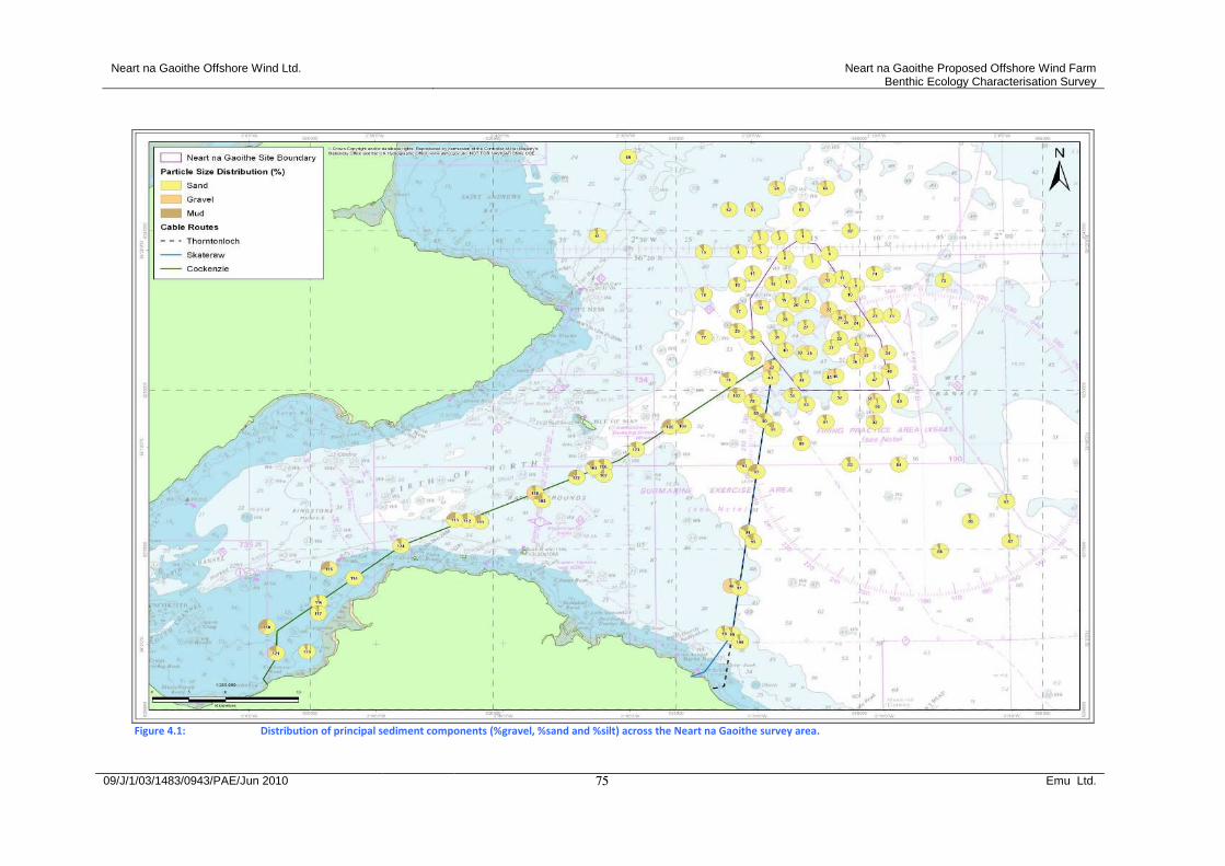
Neart na Gaoithe Offshore Wind Ltd. Neart na Gaoithe Proposed Offshore Wind Farm Benthic Ecology Characterisation Survey
09/J/1/03/1483/0943/PAE/Jun 2010 Emu Ltd.
75
Figure 4.1: Distribution of principal sediment components (%gravel, %sand and %silt) across the Neart na Gaoithe survey area.
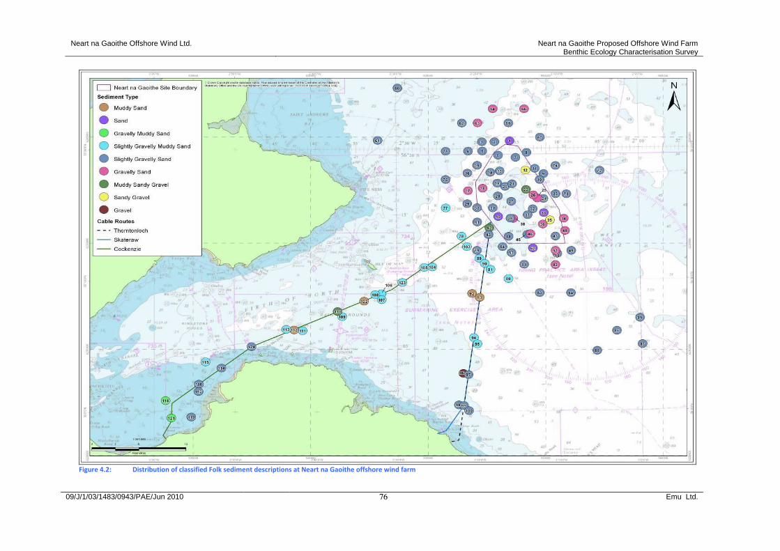
Neart na Gaoithe Offshore Wind Ltd. Neart na Gaoithe Proposed Offshore Wind Farm Benthic Ecology Characterisation Survey
09/J/1/03/1483/0943/PAE/Jun 2010 Emu Ltd.
76
Figure 4.2: Distribution of classified Folk sediment descriptions at Neart na Gaoithe offshore wind farm

Neart na Gaoithe Offshore Wind Ltd. Neart na Gaoithe Proposed Offshore Wind Farm Benthic Ecology Characterisation Survey
09/J/1/03/1483/0943/PAE/Jun 2010 Emu Ltd.
77
4.2 Sediments sampled by the grab corresponded with nine different Folk sediment categories (Table 4.2). Figure 4.2 shows their distribution across the study area.
Table 4.2: Number of sediment classifications within each treatment zone.
Gravel
Gravelly Muddy
Sand
Sandy Gravel
Muddy Sandy Gravel
Muddy Sand
Sand
Gravelly Sand
Slightly Gravelly Muddy
Sand
Slightly Gravelly
Sand
PIZ 2 1 2 6 17
SIZ 1 2 8 3 29
CPIZ 1 1 2 3 3
CSIZ 1 9 2
TPIZ 1 2 3
TSIZ 1 1 2 2
RZ 7
Total 1 2 2 3 4 4 14 19 63 (PIZ = primary impact zone within the proposed turbine array; SIZ = secondary impact zone potentially influenced by disturbed sediments. CPIZ and CSIZ = primary and secondary impact stations along the Cockenzie cable route option respectively. TPIZ and TSIZ = primary and secondary impact stations along the Torness cable route option respectively. RZ = reference zone stations).
4.3 The dominant Folk sediment classification was slightly gravelly sand. This type of sediment was
prevalent throughout the proposed turbine array and close surrounding areas. The turbine site was also associated with patches of coarser sediment material such as sandy gravel and gravelly sand. Along the two cable route options the sediments were mostly classified as slightly gravelly muddy sand and muddy sand.
4.4 Further comparison of sediment particle size data can be made using multivariate sample sorting
techniques. Figure 4.3 presents a group average dendrogram of % fractional weight sediment data, using the Euclidean distance measure of similarity, together with a series of MDS ordinations indicating those groups of sediments associated with the highest proportions of medium sand, fine sand and very fine sand.
Neart na Gaoithe Offshore Wind Ltd. Neart na Gaoithe Proposed Offshore Wind Farm Benthic Ecology Characterisation Survey
09/J/1/03/1483/0943/PAE/Jun 2010 Emu Ltd.
78
11
4
22
96
11
5
10
9
12
2
92
93
11
1
10
4
10
5
11
2
91
80
83
94
77
78
95
16
29
89
90
84
88
61
81
38
39
60
11
0
12
46
51
35
42
62
11
6
65
23
24
10
37
52 3
40
47
49
44
11
9
72
36
45
21
50
85
33
73
11
98
99 7
20
53
32
10
0
82
12
3 9
30
26
48
14
18
64
63
34
66
19
13
27
25
54 2 6
11
7 8
67 4
15
31
43
41
10
3
86
87
97
28
79
12
4 5
76
75 1
74
11
8
12
1
17
10
6
11
3
10
7
10
8
Samples
0
20
40
60
80
Dis
tance
2D Stress: 0.05
2D Stress: 0.05
2D Stress: 0.05
2D Stress: 0.05
Figure 4.3: Group average sorting dendrogram of % fraction sediment data together with corresponding MDS ordinations
indicating those groups associated with the highest proportions of medium sand, fine sand and very fine sand. (Stress = 0.05).
4.5 The multivariate sorting of sediment data revealed eight different sediment groups (Groups A –H) at a similarity level of 35% although the majority of samples fell into just three of these (Groups C, G and H). Table 4.3 presents summary sediment characteristics for each sediment group identified. Figure 4.4 shows the distribution of sediment sample groups across the study area.
Group A
Group B
Group C
Group D
▼ Group E
Group F
Group G
▲ Group H
Medium sand
Fine sand Very fine sand
Group A Group B Group C Group D ▼ Group E Group F Group G ▲ Group H
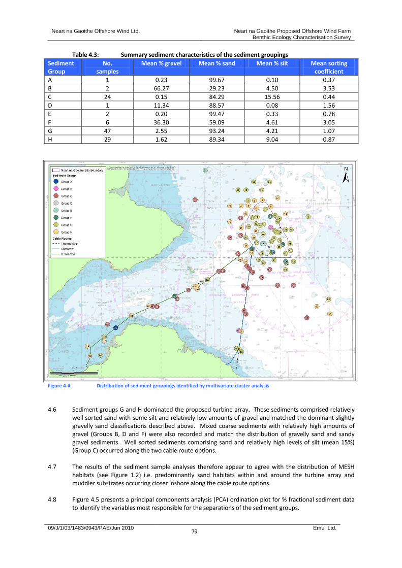
Neart na Gaoithe Offshore Wind Ltd. Neart na Gaoithe Proposed Offshore Wind Farm Benthic Ecology Characterisation Survey
09/J/1/03/1483/0943/PAE/Jun 2010 Emu Ltd.
79
Table 4.3: Summary sediment characteristics of the sediment groupings
Sediment Group
No. samples
Mean % gravel Mean % sand Mean % silt Mean sorting coefficient
A 1 0.23 99.67 0.10 0.37
B 2 66.27 29.23 4.50 3.53
C 24 0.15 84.29 15.56 0.44
D 1 11.34 88.57 0.08 1.56
E 2 0.20 99.47 0.33 0.78
F 6 36.30 59.09 4.61 3.05
G 47 2.55 93.24 4.21 1.07
H 29 1.62 89.34 9.04 0.87
Figure 4.4: Distribution of sediment groupings identified by multivariate cluster analysis
4.6 Sediment groups G and H dominated the proposed turbine array. These sediments comprised relatively well sorted sand with some silt and relatively low amounts of gravel and matched the dominant slightly gravelly sand classifications described above. Mixed coarse sediments with relatively high amounts of gravel (Groups B, D and F) were also recorded and match the distribution of gravelly sand and sandy gravel sediments. Well sorted sediments comprising sand and relatively high levels of silt (mean 15%) (Group C) occurred along the two cable route options.
4.7 The results of the sediment sample analyses therefore appear to agree with the distribution of MESH habitats (see Figure 1.2) i.e. predominantly sand habitats within and around the turbine array and muddier substrates occurring closer inshore along the cable route options.
4.8 Figure 4.5 presents a principal components analysis (PCA) ordination plot for % fractional sediment data
to identify the variables most responsible for the separations of the sediment groups.

Neart na Gaoithe Offshore Wind Ltd. Neart na Gaoithe Proposed Offshore Wind Farm Benthic Ecology Characterisation Survey
09/J/1/03/1483/0943/PAE/Jun 2010 Emu Ltd.
80
-100 -50 0 50 100
PC1
-50
0
50
100
PC
2
% V COARSE GRAVEL:% COARSE GRAVEL:% MEDIUM GRAVEL:% FINE GRAVEL:% V FINE GRAVEL:% V COARSE SAND:
% COARSE SAND:
% MEDIUM SAND:
% FINE SAND:
% V FINE SAND:
% SILT:
Figure 4.5: Principal components analysis ordination of particle size distribution data collected from grab samples.
4.9 The PC1 axis was very strongly negatively correlated with very fine sand and accounted for 70.1% of the
variation between sample groups. Fine sand accounted for a further 18.5% of the variation along the PC2 axis whilst medium sand contributed to a further 5.3% of the variation along the PC3 axis.
4.10 A 1-way ANOSIM analysis (Table 4.4) revealed low R values for pairwise comparisons between the different treatment groups. This suggested that sediment structures within the turbine array (PIZ) were not significantly different from those around the periphery (SIZ) and that sediment samples from both treatment groups were indistinguishable from reference samples (RZ). Reference stations were therefore considered to be representative of sediment within the predicted primary and secondary effects of the construction and operation of the proposed Neart na Gaoithe wind farm. Table 4.4: R-statistic values derived from a 1-way ANOSIM between sediment particle size
data from a priori treatment groups
Pairwise Tests R
statistic Significance Level %
SIZ, PIZ 0.072 3.9
SIZ, RZ 0.072 27.5
PIZ, RZ -0.024 52.3
Torness, RZ 0.256 1.5
RZ, Cockenzie 0.127 12.6
Group A
Group B
Group C
Group D
▼ Group E
Group F
Group G
▲ Group H
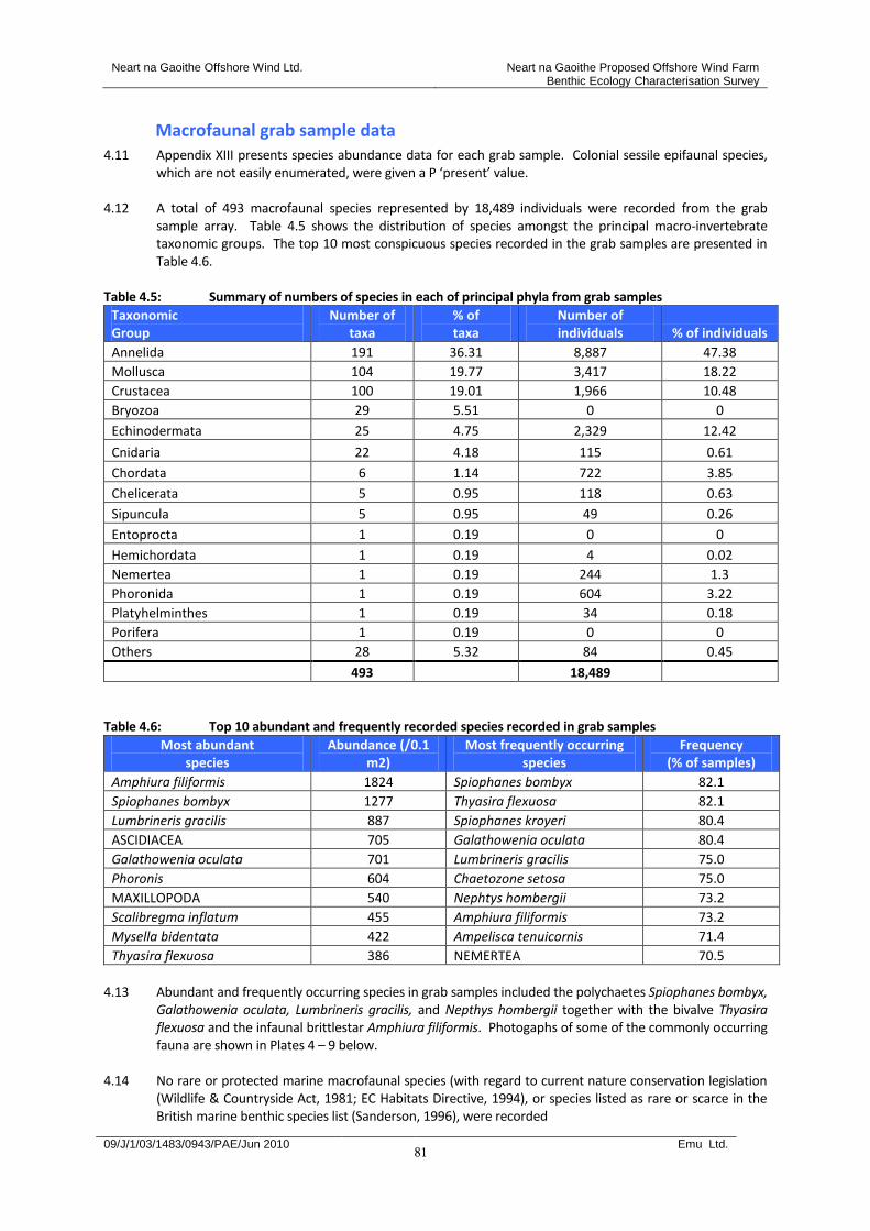
Neart na Gaoithe Offshore Wind Ltd. Neart na Gaoithe Proposed Offshore Wind Farm Benthic Ecology Characterisation Survey
09/J/1/03/1483/0943/PAE/Jun 2010 Emu Ltd.
81
Macrofaunal grab sample data 4.11 Appendix XIII presents species abundance data for each grab sample. Colonial sessile epifaunal species,
which are not easily enumerated, were given a P ‘present’ value. 4.12 A total of 493 macrofaunal species represented by 18,489 individuals were recorded from the grab
sample array. Table 4.5 shows the distribution of species amongst the principal macro-invertebrate taxonomic groups. The top 10 most conspicuous species recorded in the grab samples are presented in Table 4.6.
Table 4.5: Summary of numbers of species in each of principal phyla from grab samples
Taxonomic Group
Number of taxa
% of taxa
Number of individuals % of individuals
Annelida 191 36.31 8,887 47.38
Mollusca 104 19.77 3,417 18.22
Crustacea 100 19.01 1,966 10.48
Bryozoa 29 5.51 0 0
Echinodermata 25 4.75 2,329 12.42
Cnidaria 22 4.18 115 0.61
Chordata 6 1.14 722 3.85
Chelicerata 5 0.95 118 0.63
Sipuncula 5 0.95 49 0.26
Entoprocta 1 0.19 0 0
Hemichordata 1 0.19 4 0.02
Nemertea 1 0.19 244 1.3
Phoronida 1 0.19 604 3.22
Platyhelminthes 1 0.19 34 0.18
Porifera 1 0.19 0 0
Others 28 5.32 84 0.45
493 18,489
Table 4.6: Top 10 abundant and frequently recorded species recorded in grab samples
Most abundant species
Abundance (/0.1 m2)
Most frequently occurring species
Frequency (% of samples)
Amphiura filiformis 1824 Spiophanes bombyx 82.1
Spiophanes bombyx 1277 Thyasira flexuosa 82.1
Lumbrineris gracilis 887 Spiophanes kroyeri 80.4
ASCIDIACEA 705 Galathowenia oculata 80.4
Galathowenia oculata 701 Lumbrineris gracilis 75.0
Phoronis 604 Chaetozone setosa 75.0
MAXILLOPODA 540 Nephtys hombergii 73.2
Scalibregma inflatum 455 Amphiura filiformis 73.2
Mysella bidentata 422 Ampelisca tenuicornis 71.4
Thyasira flexuosa 386 NEMERTEA 70.5
4.13 Abundant and frequently occurring species in grab samples included the polychaetes Spiophanes bombyx,
Galathowenia oculata, Lumbrineris gracilis, and Nepthys hombergii together with the bivalve Thyasira flexuosa and the infaunal brittlestar Amphiura filiformis. Photogaphs of some of the commonly occurring fauna are shown in Plates 4 – 9 below.
4.14 No rare or protected marine macrofaunal species (with regard to current nature conservation legislation (Wildlife & Countryside Act, 1981; EC Habitats Directive, 1994), or species listed as rare or scarce in the British marine benthic species list (Sanderson, 1996), were recorded
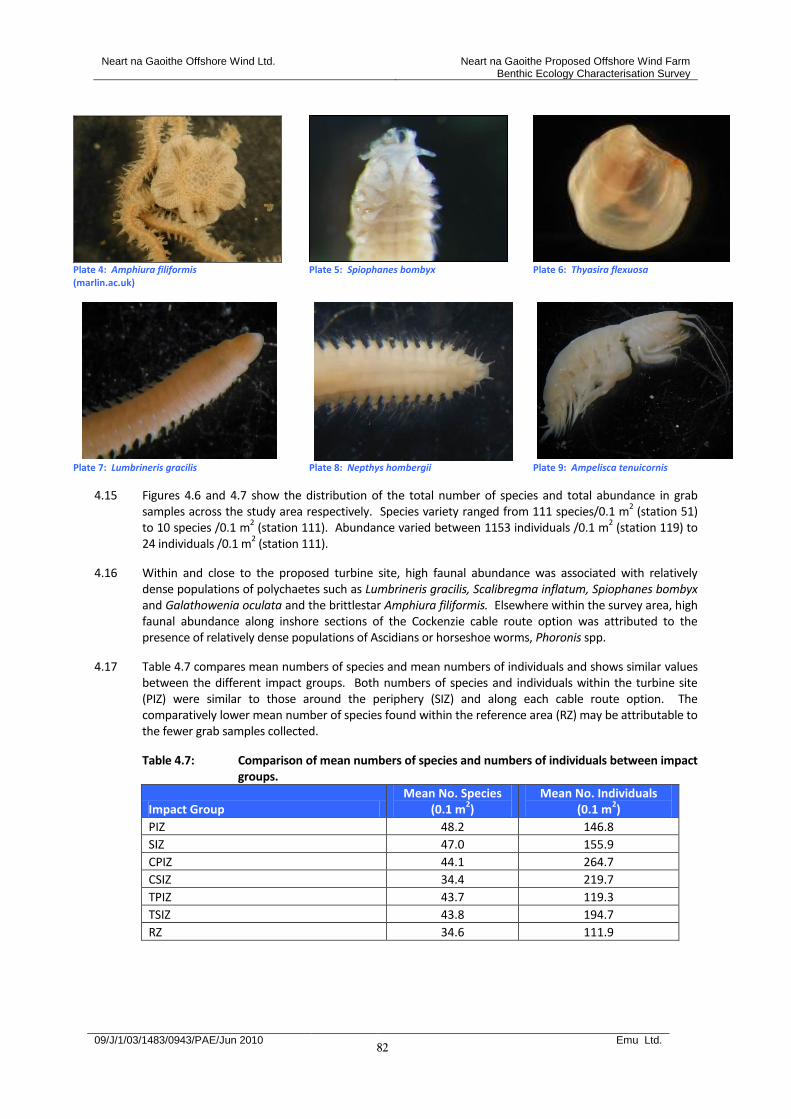
Neart na Gaoithe Offshore Wind Ltd. Neart na Gaoithe Proposed Offshore Wind Farm Benthic Ecology Characterisation Survey
09/J/1/03/1483/0943/PAE/Jun 2010 Emu Ltd.
82
Plate 4: Amphiura filiformis (marlin.ac.uk)
Plate 5: Spiophanes bombyx Plate 6: Thyasira flexuosa
Plate 7: Lumbrineris gracilis Plate 8: Nepthys hombergii Plate 9: Ampelisca tenuicornis
4.15 Figures 4.6 and 4.7 show the distribution of the total number of species and total abundance in grab samples across the study area respectively. Species variety ranged from 111 species/0.1 m
2 (station 51)
to 10 species /0.1 m2 (station 111). Abundance varied between 1153 individuals /0.1 m
2 (station 119) to
24 individuals /0.1 m2 (station 111).
4.16 Within and close to the proposed turbine site, high faunal abundance was associated with relatively dense populations of polychaetes such as Lumbrineris gracilis, Scalibregma inflatum, Spiophanes bombyx and Galathowenia oculata and the brittlestar Amphiura filiformis. Elsewhere within the survey area, high faunal abundance along inshore sections of the Cockenzie cable route option was attributed to the presence of relatively dense populations of Ascidians or horseshoe worms, Phoronis spp.
4.17 Table 4.7 compares mean numbers of species and mean numbers of individuals and shows similar values between the different impact groups. Both numbers of species and individuals within the turbine site (PIZ) were similar to those around the periphery (SIZ) and along each cable route option. The comparatively lower mean number of species found within the reference area (RZ) may be attributable to the fewer grab samples collected.
Table 4.7: Comparison of mean numbers of species and numbers of individuals between impact groups.
Impact Group Mean No. Species
(0.1 m2)
Mean No. Individuals (0.1 m
2)
PIZ 48.2 146.8
SIZ 47.0 155.9
CPIZ 44.1 264.7
CSIZ 34.4 219.7
TPIZ 43.7 119.3
TSIZ 43.8 194.7
RZ 34.6 111.9

Neart na Gaoithe Offshore Wind Ltd. Neart na Gaoithe Proposed Offshore Wind Farm Benthic Ecology Characterisation Survey
09/J/1/03/1483/0943/PAE/Jun 2010 Emu Ltd.
83
Figure 4.6: Distribution of numbers of species in 0.1 m2 grab samples at Neart na Gaoithe
Figure 4.7: Distribution of numbers of individuals in 0.1 m2 grab samples at Neart na Gaoithe
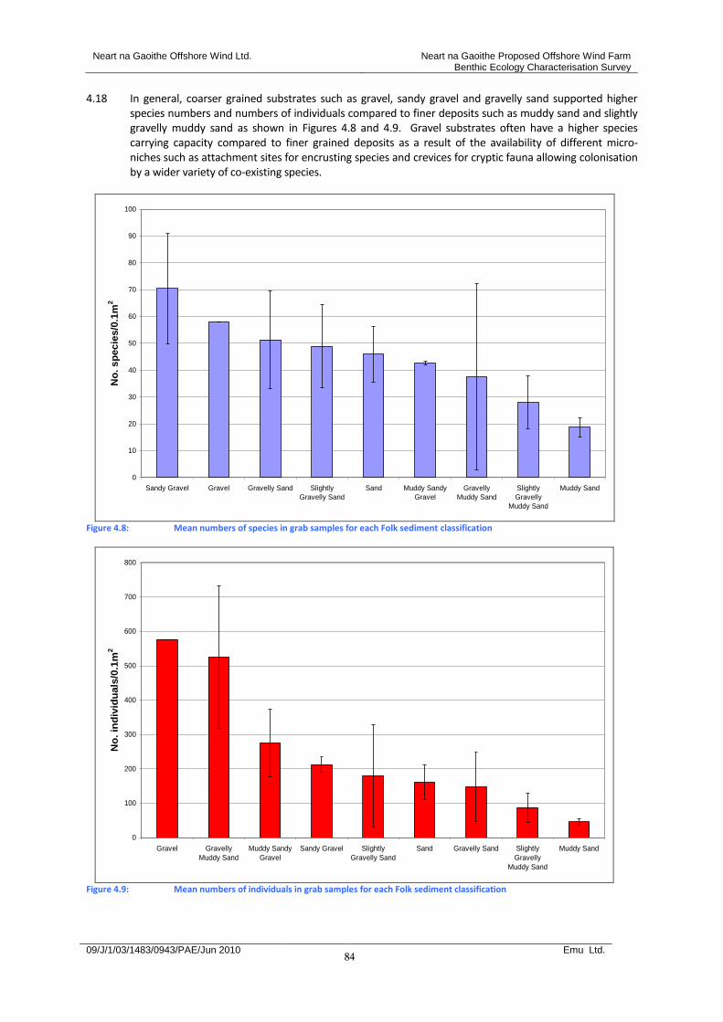
Neart na Gaoithe Offshore Wind Ltd. Neart na Gaoithe Proposed Offshore Wind Farm Benthic Ecology Characterisation Survey
09/J/1/03/1483/0943/PAE/Jun 2010 Emu Ltd.
84
4.18 In general, coarser grained substrates such as gravel, sandy gravel and gravelly sand supported higher species numbers and numbers of individuals compared to finer deposits such as muddy sand and slightly gravelly muddy sand as shown in Figures 4.8 and 4.9. Gravel substrates often have a higher species carrying capacity compared to finer grained deposits as a result of the availability of different micro-niches such as attachment sites for encrusting species and crevices for cryptic fauna allowing colonisation by a wider variety of co-existing species.
0
10
20
30
40
50
60
70
80
90
100
Sandy Gravel Gravel Gravelly Sand Slightly
Gravelly Sand
Sand Muddy Sandy
Gravel
Gravelly
Muddy Sand
Slightly
Gravelly
Muddy Sand
Muddy Sand
No
. sp
ecie
s/0
.1m
2
Figure 4.8: Mean numbers of species in grab samples for each Folk sediment classification
0
100
200
300
400
500
600
700
800
Gravel Gravelly
Muddy Sand
Muddy Sandy
Gravel
Sandy Gravel Slightly
Gravelly Sand
Sand Gravelly Sand Slightly
Gravelly
Muddy Sand
Muddy Sand
No
. in
div
idu
als
/0.1
m2
Figure 4.9: Mean numbers of individuals in grab samples for each Folk sediment classification
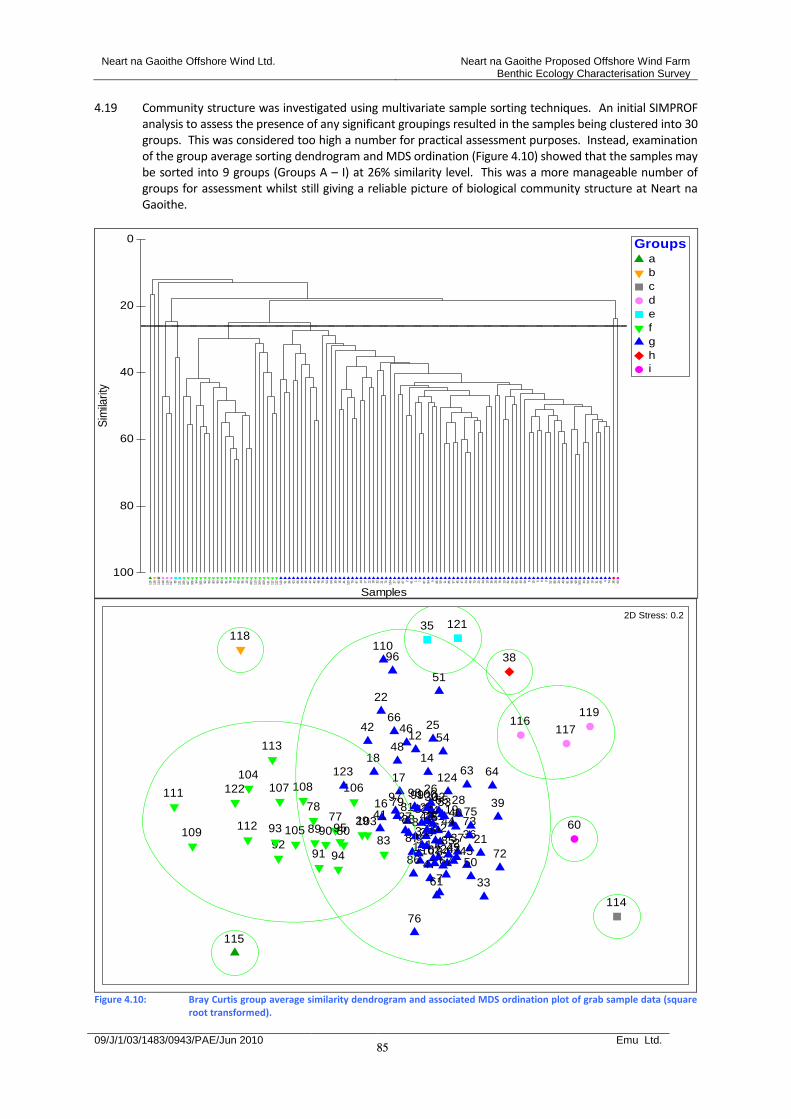
Neart na Gaoithe Offshore Wind Ltd. Neart na Gaoithe Proposed Offshore Wind Farm Benthic Ecology Characterisation Survey
09/J/1/03/1483/0943/PAE/Jun 2010 Emu Ltd.
85
4.19 Community structure was investigated using multivariate sample sorting techniques. An initial SIMPROF analysis to assess the presence of any significant groupings resulted in the samples being clustered into 30 groups. This was considered too high a number for practical assessment purposes. Instead, examination of the group average sorting dendrogram and MDS ordination (Figure 4.10) showed that the samples may be sorted into 9 groups (Groups A – I) at 26% similarity level. This was a more manageable number of groups for assessment whilst still giving a reliable picture of biological community structure at Neart na Gaoithe.
115
118
114
119
116
117 35 121
106
107
108 94 105 92 93 83 90 89 91 78 77 80 95 29 103
113
104
109
111
112
122
110 51 96 63 66 25 46 22 42 48 76 54 64 39 16 41 123 79 97 14 17 12 18 33 21 72 124 27 62 67 2 61 1 7 87 84 9 86 50 11 85 37 45 47 24 49 73 23 34 10 36 28 75 13 32 26 82 40 30 5 15 6 8 3 52 88 20 43 81 98 99 100 44 53 19 31 65 4 74 38 60
Samples
100
80
60
40
20
0
Sim
ilari
ty
Groupsa
b
c
d
e
f
g
h
i
1 2
34
5 6
7
8
91011
12
13
14
15
16
17
18
1920
21
22
23
24
25
26
27
28
29
30
31
32
33
34
35
3637
38
394041
42
43 44
45
46
47
48
49
50
51
52
53
54
60
61
62
63 64
65
66
6772
7374 75
76
7778 79
80
8182
838485
86
87
888990
9192
93
94
95
96
97 9899100
103
104
105
106107 108
109
110
111
112
113
114
115
116117
118
119
121
122
123124
2D Stress: 0.2
Figure 4.10: Bray Curtis group average similarity dendrogram and associated MDS ordination plot of grab sample data (square
root transformed).

Neart na Gaoithe Offshore Wind Ltd. Neart na Gaoithe Proposed Offshore Wind Farm Benthic Ecology Characterisation Survey
09/J/1/03/1483/0943/PAE/Jun 2010 Emu Ltd.
86
4.20 Figure 4.11 shows the distribution of the faunal clusters overlaid onto the sample array. Example seabed photographs of substrate types and other biological features associated with some of the faunal groups are also presented. These show the presence of sea pens (Pennatula phosphorea and Virgularia mirabilis) and the sediment burrows and mounds produced by megafauna such as the Norway lobster Nephrops norvegicus and which may be under-represented during grab sampling surveys.
Figure 4.11: Grab sample array overlaid with classified groupings from multivariate analysis and illustrative seabed images.
4.21 Table 4.8 presents a summary of the biological and physical attributes of each of the faunal sample groupings. This includes lists of species characteristic of each sample grouping and derived from a rank of abundance and also from a SIMPER analysis identifying those species contributing most to the internal similarity of each grouping.
4.22 The majority of the samples (71.4%) were clustered into Group G. This included samples collected from
the proposed turbine array, peripheral areas and reference areas. It was characterised by slightly gravelly sand and gravelly sand substrates with small amounts of silt (around 5%) supporting the infaunal brittlestar, Amphiura filiformis, the polychaetes Spiophanes bombyx, Galathowenia oculata and Lumbrineris gracilis and the bivalves Mysella bidentata and Thyasira flexuosa. The sea pens Pennatula phosporea and Virgularia mirabilis were also associated with this group as evidenced by the seabed imagery. Conspicuous sessile epifauna included the bryozoans Eucratea loricata and Alcyonidium parasiticum, Flustra foliacea and Escharella immersa. The grab data corresponded with a SS.SMu.CSaMu.AfilNten biotope classification describing Amphiura filiformis and Nuculoma tenuis in circalittoral and offshore sandy mud. (Connor et al., 2004)
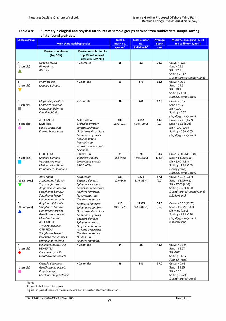
Neart na Gaoithe Offshore Wind Ltd. Neart na Gaoithe Proposed Offshore Wind Farm Benthic Ecology Characterisation Survey
09/J/1/03/1483/0943/PAE/Jun 2010 Emu Ltd.
87
Table 4.8: Summary biological and physical attributes of sample groups derived from multivariate sample sorting of the faunal grab data.
Sample group Main characterising species
Total & mean no. species1
Total & mean no.
individuals2
Average depth
(m)
Mean % sand, gravel & silt and sediment type(s).
Ranked abundance (Top 50%)
Ranked contribution to top 50% of internal similarity (SIMPER)
A (1 sample)
Nephtys incisa Phoronis sp. Abra sp.
< 2 samples
16 32 30.8 Gravel = 0.35 Sand = 72.1 Silt = 27.5 Sorting = 0.42 (Slightly gravelly muddy sand)
B (1 sample)
Phoronis spp. Melinna palmata
< 2 samples
13 379 18.6 Gravel = 10.9 Sand = 59.2 Silt = 29.9 Sorting = 1.60 (Gravelly muddy sand)
C (1 sample)
Magelona johnstoni Chamelea striatula Magelona filiformis Fabulina fabula
< 2 samples
36 244 17.5 Gravel = 0.27 Sand = 99.7 Silt = 0.10 Sorting = 0.37 (Slightly gravelly sand)
D (3 samples)
ASCIDIACEA Mytilidae Lanice conchilega Eumida bahusiensis
ASCIDIACEA Scoloplos armiger Lanice conchilega Galathowenia oculata Lumbrineris gracilis Fabulina fabula Phoronis spp. Ampelisca brevicornis Mytilidae
139 96.6 (12.1)
2052 684 (409.9)
14.6 (3.7)
Gravel = 2.20 (1.77) Sand = 93.1 (1.03) Silt = 4.70 (0.75) Sorting = 0.80 (0.05) (Slightly gravelly sand)
E (2 samples)
CIRRIPEDIA Melinna palmata Verruca stroemia Melinna elisabthae Pomatoceros lamarcki
CIRRIPEDIA Verruca stroemia Lumbrineris gracilis ASCIDIACEA
81 58.5 (4.9)
890 454 (313.9)
30.7 (24.4)
Gravel = 30.26 (16.08) Sand = 61.25 (6.90) Silt = 8.49 (9.18) Sorting = 2.74 (0.05) (Sandy gravel) (Gravelly muddy sand)
F (23 samples)
Abra nitida Scalibregma inflatum Thyasira flexuosa Ampelisca tenuicornis Spiophanes bombyx Spiophanes kroyeri Harpinia antennaria
Abra nitida Thyasira flexuosa Spiophanes kroyeri Ampelisca tenuicornis Nephtys hombergii Notomastus spp. Chaetozone setosa
134 27.0 (9.3)
1876 81.6 (39.4)
57.1 (6.2)
Gravel = 0.16 (0.17) Sand = 82.75 (6.22) Silt = 17.09 (6.31) Sorting = 0.50 (0.20) (Slightly gravelly muddy sand) (Muddy sand)
G (80 samples)
Amphiura filiformis Spiophanes bombyx Lumbrineris gracilis Galathowenia oculata Mysella bidentata ASCIDIACEA Thyasira flexuosa CIRRIPEDIA Spiophanes kroyeri Peresiella clymenoides Harpinia antennaria
Amphiura filiformis Spiophanes bombyx Galathowenia oculata Lumbrineris gracilis Thyasira flexuosa Spiophanes kroyeri Harpinia antennaria Peresiella clymenoides
Chaetozone setosa NEMERTEA Nephtys hombergii
413 48.1 (12.9)
12993 164.4 (86.1)
55.5 (5.7)
Gravel = 5.56 (13.70) Sand = 89.52 (13.83) Silt =4.92 (1.99) Sorting = 1.15 (0.76) (Slightly gravelly sand) (Gravelly sand)
H (1 sample)
Echinocyamus pusillus NEMERTEA Goniadella gracilis Galathowenia oculata
< 2 samples
34 58 48.7 Gravel = 11.34 Sand = 88.57 Silt =0.08 Sorting = 1.56 (Gravelly sand)
I (1 sample)
Crenella decussata Galathowenia oculata Polycirrus spp. Cochlodesma praetenue
< 2 samples
39 141 37.0 Gravel = 0.03 Sand = 99.35 Silt = 0.35 Sorting = 0.79 (Slightly gravelly sand)
Notes Figures in bold are total values. Figures in parentheses are mean numbers and associated standard deviations
Neart na Gaoithe Offshore Wind Ltd. Neart na Gaoithe Proposed Offshore Wind Farm Benthic Ecology Characterisation Survey
09/J/1/03/1483/0943/PAE/Jun 2010 Emu Ltd.
88
4.23 Image analysis showed that many sampled locations within Group G supported sea pens Pennatula phosphorea and Virgularia mirabilis. Also present were Pholoe spp., Glycera spp., Nephtys spp., spionids, Terebellides stroemi as well as large fauna such as the sea urchin Brissopsis lyrifera.
4.24 Although not definitive in some ways (i.e. many more Echinocardium than Brissopsis and sediment
analysis giving a description of slightly gravelly sand/gravelly sand) the stations within Group G corresponded with the biotope SS.SMu.CFiMu.SpnMeg describing sea pens and burrowing megafauna in circalittoral fine mud (Connor et al, 2004).
4.25 The next largest faunal grouping was Group F. This group incorporated a further 20% of the grab
samples and included those collected along the majority of the cable route options (Figure 4.11). The sediments were dominated by slightly gravelly muddy sand and muddy sand. Mean silt content was higher than that recorded within Group G (17%). Characteristic species included the bivalves Abra nitida and T. flexuosa, the polychaetes Scalibregma inflatum, Nephtys hombergii, Chaetozone setosa, Spiophanes bombyx and S. kroyeri and the amphipods Ampelisca tenuicornis and Harpinia antennaria. The seabed imagery recorded the squat lobster Munida rugosa and burrows of Nephrops norvegicus associated with this grouping. Colonial sessile epifauna were mot associated with this grouping.
4.26 The habitat present corresponded with the sub-littoral cohesive mud and sandy mud community (SS.SMU) biotopes although the muddy sand/slightly gravelly muddy sand sediments recorded at Neart na Gaoithe differed slightly from the sandy mud sediment described by Connor et al (2004). The particular biotope fell between Thyasira spp. and Nuculoma tenuis in circalittoral sandy mud (SS.SMU.CSaMu.ThyNten) and Amphiura filiformis, Mysella bidentata and Abra nitida in circalittoral sandy mud (SS.SMu.CSaMu.AfilMysAnit). The former contained many of the characterising species of group F including Thyasira flexuosa, Spiophanes kroyeri, Ampelisca tenuicornis, Nephtys, Chaetozone setosa, Scalibregma inflatum, Harpinia antennaria, and Goniada maculata. However the latter biotope was favoured in this instance as a result of the dominance of Abra nitida in grab samples.
4.27 The other faunal clusters present only comprised one or a few samples only and were mostly located
along the inshore section of the Cockenzie cable route option (Figure 4.11). These smaller groupings reflected the mixed substrate habitats and associated faunal communities present at this location and included coarser sediment types such as gravelly muddy sand and sandy gravel (Groups B and E) with associated encrusting and attaching fauna i.e. barnacles Cirripedia and Verruca stroemi, encrusting worms Pomatoceros lamarcki and sea squirts Ascidiacea. Other mixed sand and gravel sediments such as those within Group D were also characterised by attaching and encrusting species including sea squirts and mussels Mytilidae together with a wide range of other infaunal species including the polychaetes Scoloplos armiger, Lanice conchilega, Galathowenia oculata, Lumbrineris gracilis, the bivalve Fabulina fabula and the amphipod Ampelisca brevicornis.
4.28 Muddy sand sediments (Group A) were characterised by the polychaete Nepthys incisa, the horseshoe worm Phoronis sp. and the bivalve Abra sp. but in areas of reduced silt content (Group C) the fauna comprised typical sand species such as the polychaetes Magelona johnstoni and M. filiformis and the bivalves Fabulina fabula and Chamelea striatula
4.29 In general, each of the multivariate grab sample groups corresponded well with the Marine Habitat
Classification. The following summarises the different habitat and biotope complexes and biotopes identified for each grouping. Expert judgement was used to match survey data to the Marine Habitat Classification for the derivation of biotope codes
4.30 Groups A and B (stations 115 and 118 respectively) corresponded with the biotope complex
SS.SMu.CSaMu relating to circalittoral sandy mud.
Neart na Gaoithe Offshore Wind Ltd. Neart na Gaoithe Proposed Offshore Wind Farm Benthic Ecology Characterisation Survey
09/J/1/03/1483/0943/PAE/Jun 2010 Emu Ltd.
89
4.31 The sediment type and associated species for Group C (Station 114) matched the SS.SSA.IMuSa.FfabMag classification describing the bivalve Fabulina fabula and the polychaete Magelona mirabilis with venerid bivalves and amphipods in infralittoral compacted fine muddy sand. The clear lack of mud at this station is reflected in the presence of species such as Mactra stultorum (Linnaeus, 1758) and Iphinoe trispinosa (Goodsir, 1843) both of which prefer sandy habitats, the former clean sand (rarely muddy) and the latter fine sand.
4.32 In contrast, Group D (Stations 116, 117 and 119) did not fit easily into any one biotope. The physical
sediment and depth attributes of this grouping broadly fitted the biotope complex SS.SMU.ISaMu describing infralittoral sandy mud sediments whilst the presence of subordinate Mysella bidentata and Abra spp. indicated a match with SS.SMU.ISaMu.MysAbr. The presence of tube dwelling amphipods such as A. brevicornis and Monocorophium sextonae further supported the assignation of this biotope. Connor et al (2004) noted that this biotope may be part of a wider biotope and contain ‘more than one entity depending on its geographic location and prevailing environmental conditions’. Another possible match, based on other characterising species present such as Eumida bahusiensis and Lanice conchilega, is SS.SCS.ICS.SLan describing dense Lanice conchilega and other polychaetes in tide-swept infralittoral sand and mixed gravelly sand’. Despite the apparent absence of a number of other characterising species from the biotope description (Connor et al, 2004), the SLan classification was favoured for this area because it was also identified nearby on the lower shore and sublittoral fringe during the site specific intertidal survey at Cockenzie (see section 3.0) and may therefore be continuos with coastal habitats.
4.33 The grouping was geographically close to groups A-B and had elements of some of the fauna found at
these stations, in particular Phoronis, Fabulina fabula and Abra. For group D Abra alba occurred in relatively high abundance at two of the stations and was present at the third. This species does well in disturbed conditions (Gofas, 2009) and it is likely this is an important feature of the conditions in this area and contributes to the difficulty in placing group D into any one biotope
4.34 The infaunal similarity between the two stations incorporating Group E (stations 121 and 35) was
comparatively low with SIMPER identifying encrusting fauna and the polychaete Lumbrineris gracilis as the largest contributors to the internal group similarity (Table 3.5). Species characteristic to both samples included the barnacles Cirripedia and Verruca stroemi, with other abundant infauna, Melinna palmata and M. elisabethae only occurring closer inshore along the Cockenzie cable route option (station 121). The two samples were not geographically related and differed in terms of sediment classification and depth. Consequently, it was considered inappropriate to consider a collective biotope in this instance.
4.35 The shallow inshore station 121 matched the circalittoral sandy mud SS.SMU.CSaMu biotope with the
presence of Melinna sp. and Scalibregma inflatum but should probably be classified as ISaMu based on the shallower water depth recorded at this station (13.4 m). Station 35 however was located further offshore and in deeper water (48 m) and was characterised by Ophiothrix fragilis and Lumbrineris gracilis and corresponding with the circalittoral mixed sediment (SS.SMX.CMx) biotope.
4.36 Groups H and I (stations 38 and 60 respectively) matched the habitats SS.SCS.CCS describing circalittoral coarse sediment.
4.37 Table 4.96 presents R-statistics derived from a 1-way ANOSIM test for significant spatial differences in
community structure between a priori treatment groups.

Neart na Gaoithe Offshore Wind Ltd. Neart na Gaoithe Proposed Offshore Wind Farm Benthic Ecology Characterisation Survey
09/J/1/03/1483/0943/PAE/Jun 2010 Emu Ltd.
90
Table 4.9: R-statistic values derived from a 1-way ANOSIM between sediment particle size data from a priori treatment groups to detect spatial differences in sediment structure
Pairwise Tests R
statistic Significance Level %
SIZ, PIZ 0.072 3.9
SIZ, RZ 0.072 27.5
PIZ, RZ -0.024 52.3
Torness, RZ 0.256 1.5
RZ, Cockenzie 0.127 12.6
4.38 The low values of R obtained suggested that there were no significant spatial differences in community
structure across the sampling array. In particular, biological communities within the predicted primary and secondary influences of the construction of the wind farm (PIZ and SIZ) were found to be indistinguishable from those within the reference zone (RZ) highlighting the suitability of the reference stations selected.
4.39 BIOENV analysis was used to assess the abiotic variables that best matched the observed distribution of
macrofauna from the multivariate sample sorting, the results of which are presented in Table 4.10. Input variables were normalised prior to the analysis and included the sediment fractions, sorting, mean particle diameter and depth. The results showed that % silt was the single abiotic variable that best matched the observed macrofaunal distribution. The correlation was improved with the addition of mean particle diameter and depth.
Table 4.10: Summary results of the BIOENV analysis
Abiotic Factor(s) Correlation Coefficient (r)
Single factor % Silt
0.582
Combination of factors Depth, mean particle diameter and % silt Depth, mean particle diameter, % coarse sand, % fine sand and % silt Depth, sorting, % coarse sand, % fine sand and % silt Depth, mean particle diameter, % very coarse gravel and % silt
0.804 0.802 0.800 0.797
Seabed Image Data 4.40 Seabed images were collected at each grab sample station and at other selected sites judged to be
unsuitable for grab sampling as a result of the presence of hard, rocky substrates as evidenced by acoustic survey data (see Figure 1.3). The images confirmed the dominance of muddy sand sediments at Neart na Gaoithe but also revealed the nature of the hard, rocky areas of seabed and associated species communities which the prior acoustic survey identified as occurring as patches throughout the survey area probably represented exposed Wee Bankie formation.
4.41 Video transects over selected exposures of hard, rocky seabed showed a typical succession of sediment
habitat types from muddy sand to coarse gravel, cobbles and boulders and returning to muddy sand once the camera had passed over the exposure. The following photo montages (Plate 10) illustrate the typical sequence of the different habitat types present along transect lines across two boulder and cobble exposures within the proposed turbine site.
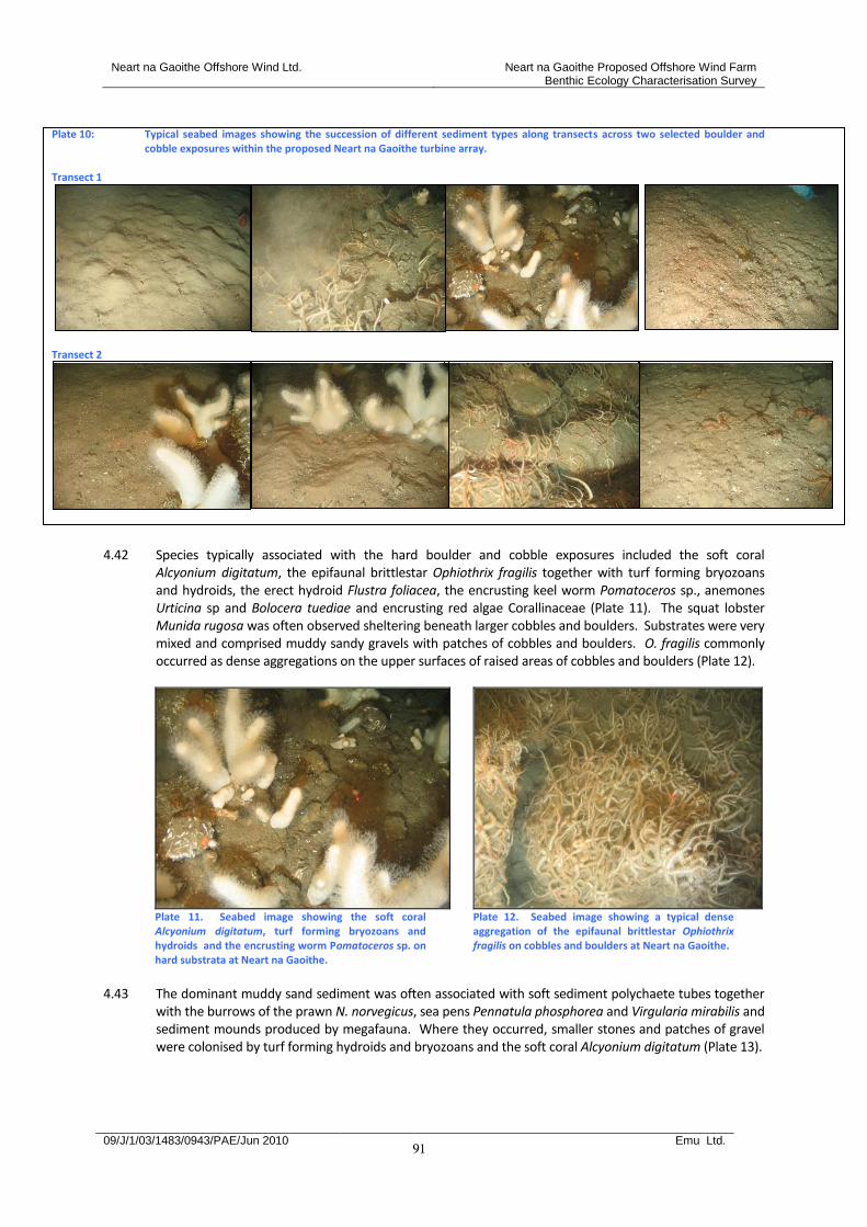
Neart na Gaoithe Offshore Wind Ltd. Neart na Gaoithe Proposed Offshore Wind Farm Benthic Ecology Characterisation Survey
09/J/1/03/1483/0943/PAE/Jun 2010 Emu Ltd.
91
Plate 10: Typical seabed images showing the succession of different sediment types along transects across two selected boulder and
cobble exposures within the proposed Neart na Gaoithe turbine array. Transect 1
Transect 2
4.42 Species typically associated with the hard boulder and cobble exposures included the soft coral
Alcyonium digitatum, the epifaunal brittlestar Ophiothrix fragilis together with turf forming bryozoans and hydroids, the erect hydroid Flustra foliacea, the encrusting keel worm Pomatoceros sp., anemones Urticina sp and Bolocera tuediae and encrusting red algae Corallinaceae (Plate 11). The squat lobster Munida rugosa was often observed sheltering beneath larger cobbles and boulders. Substrates were very mixed and comprised muddy sandy gravels with patches of cobbles and boulders. O. fragilis commonly occurred as dense aggregations on the upper surfaces of raised areas of cobbles and boulders (Plate 12).
Plate 11. Seabed image showing the soft coral Alcyonium digitatum, turf forming bryozoans and hydroids and the encrusting worm Pomatoceros sp. on hard substrata at Neart na Gaoithe.
Plate 12. Seabed image showing a typical dense aggregation of the epifaunal brittlestar Ophiothrix fragilis on cobbles and boulders at Neart na Gaoithe.
4.43 The dominant muddy sand sediment was often associated with soft sediment polychaete tubes together
with the burrows of the prawn N. norvegicus, sea pens Pennatula phosphorea and Virgularia mirabilis and sediment mounds produced by megafauna. Where they occurred, smaller stones and patches of gravel were colonised by turf forming hydroids and bryozoans and the soft coral Alcyonium digitatum (Plate 13).
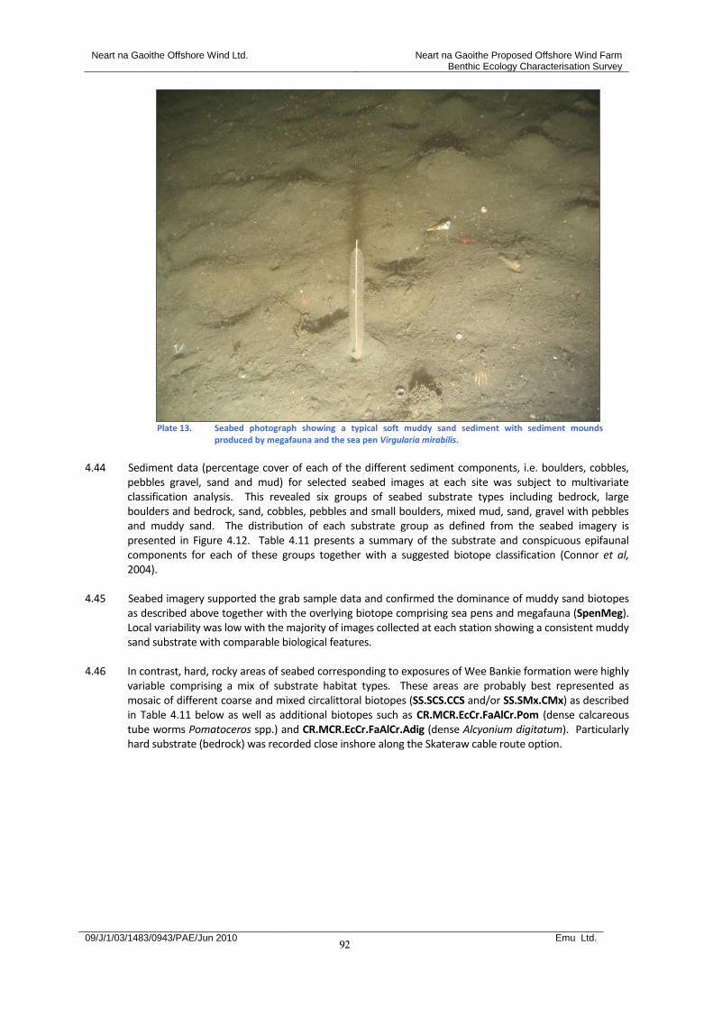
Neart na Gaoithe Offshore Wind Ltd. Neart na Gaoithe Proposed Offshore Wind Farm Benthic Ecology Characterisation Survey
09/J/1/03/1483/0943/PAE/Jun 2010 Emu Ltd.
92
Plate 13. Seabed photograph showing a typical soft muddy sand sediment with sediment mounds
produced by megafauna and the sea pen Virgularia mirabilis.
4.44 Sediment data (percentage cover of each of the different sediment components, i.e. boulders, cobbles,
pebbles gravel, sand and mud) for selected seabed images at each site was subject to multivariate classification analysis. This revealed six groups of seabed substrate types including bedrock, large boulders and bedrock, sand, cobbles, pebbles and small boulders, mixed mud, sand, gravel with pebbles and muddy sand. The distribution of each substrate group as defined from the seabed imagery is presented in Figure 4.12. Table 4.11 presents a summary of the substrate and conspicuous epifaunal components for each of these groups together with a suggested biotope classification (Connor et al, 2004).
4.45 Seabed imagery supported the grab sample data and confirmed the dominance of muddy sand biotopes
as described above together with the overlying biotope comprising sea pens and megafauna (SpenMeg). Local variability was low with the majority of images collected at each station showing a consistent muddy sand substrate with comparable biological features.
4.46 In contrast, hard, rocky areas of seabed corresponding to exposures of Wee Bankie formation were highly
variable comprising a mix of substrate habitat types. These areas are probably best represented as mosaic of different coarse and mixed circalittoral biotopes (SS.SCS.CCS and/or SS.SMx.CMx) as described in Table 4.11 below as well as additional biotopes such as CR.MCR.EcCr.FaAlCr.Pom (dense calcareous tube worms Pomatoceros spp.) and CR.MCR.EcCr.FaAlCr.Adig (dense Alcyonium digitatum). Particularly hard substrate (bedrock) was recorded close inshore along the Skateraw cable route option.
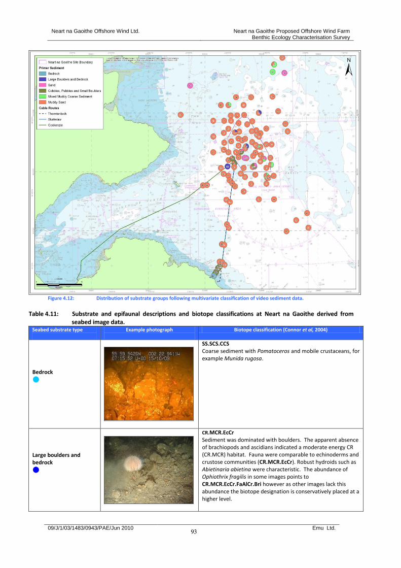
Neart na Gaoithe Offshore Wind Ltd. Neart na Gaoithe Proposed Offshore Wind Farm Benthic Ecology Characterisation Survey
09/J/1/03/1483/0943/PAE/Jun 2010 Emu Ltd.
93
Figure 4.12: Distribution of substrate groups following multivariate classification of video sediment data.
Table 4.11: Substrate and epifaunal descriptions and biotope classifications at Neart na Gaoithe derived from
seabed image data. Seabed substrate type
Example photograph
Biotope classification (Connor et al, 2004)
Bedrock
SS.SCS.CCS Coarse sediment with Pomatoceros and mobile crustaceans, for example Munida rugosa.
Large boulders and bedrock
CR.MCR.EcCr Sediment was dominated with boulders. The apparent absence of brachiopods and ascidians indicated a moderate energy CR (CR.MCR) habitat. Fauna were comparable to echinoderms and crustose communities (CR.MCR.EcCr). Robust hydroids such as Abietinaria abietina were characteristic. The abundance of Ophiothrix fragilis in some images points to CR.MCR.EcCr.FaAlCr.Bri however as other images lack this abundance the biotope designation is conservatively placed at a higher level.
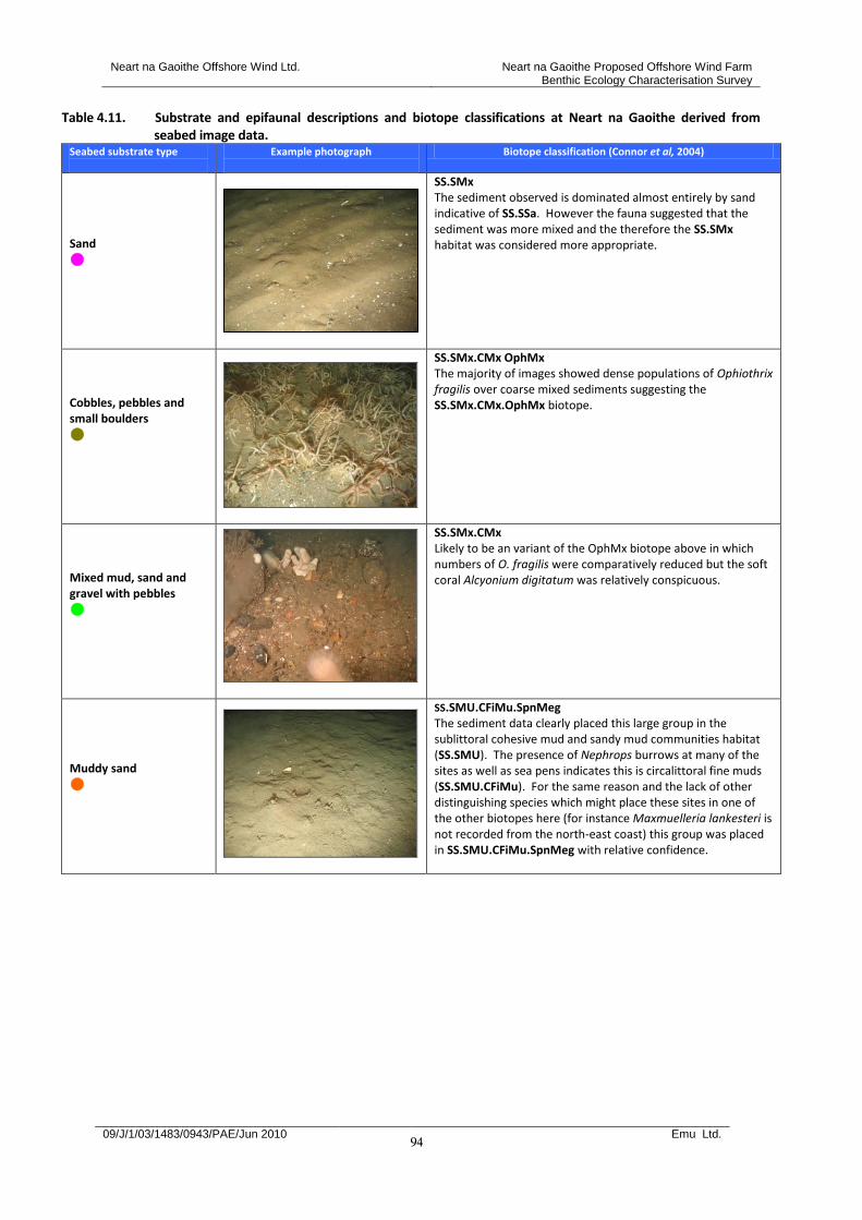
Neart na Gaoithe Offshore Wind Ltd. Neart na Gaoithe Proposed Offshore Wind Farm Benthic Ecology Characterisation Survey
09/J/1/03/1483/0943/PAE/Jun 2010 Emu Ltd.
94
Table 4.11. Substrate and epifaunal descriptions and biotope classifications at Neart na Gaoithe derived from seabed image data.
Seabed substrate type
Example photograph
Biotope classification (Connor et al, 2004)
Sand
SS.SMx The sediment observed is dominated almost entirely by sand indicative of SS.SSa. However the fauna suggested that the sediment was more mixed and the therefore the SS.SMx habitat was considered more appropriate.
Cobbles, pebbles and small boulders
SS.SMx.CMx OphMx The majority of images showed dense populations of Ophiothrix fragilis over coarse mixed sediments suggesting the SS.SMx.CMx.OphMx biotope.
Mixed mud, sand and gravel with pebbles
SS.SMx.CMx Likely to be an variant of the OphMx biotope above in which numbers of O. fragilis were comparatively reduced but the soft coral Alcyonium digitatum was relatively conspicuous.
Muddy sand
SS.SMU.CFiMu.SpnMeg The sediment data clearly placed this large group in the sublittoral cohesive mud and sandy mud communities habitat (SS.SMU). The presence of Nephrops burrows at many of the sites as well as sea pens indicates this is circalittoral fine muds (SS.SMU.CFiMu). For the same reason and the lack of other distinguishing species which might place these sites in one of the other biotopes here (for instance Maxmuelleria lankesteri is not recorded from the north-east coast) this group was placed in SS.SMU.CFiMu.SpnMeg with relative confidence.
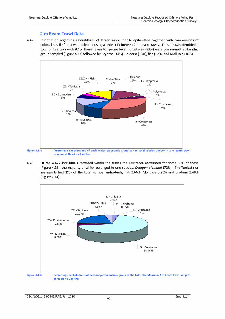
Neart na Gaoithe Offshore Wind Ltd. Neart na Gaoithe Proposed Offshore Wind Farm Benthic Ecology Characterisation Survey
09/J/1/03/1483/0943/PAE/Jun 2010 Emu Ltd.
95
2 m Beam Trawl Data 4.47 Information regarding assemblages of larger, more mobile epibenthos together with communities of
colonial sessile fauna was collected using a series of nineteen 2 m beam trawls. These trawls identified a total of 123 taxa with 97 of these taken to species level. Crustacea (32%) were commonest epibenthic group sampled (Figure 4.13) followed by Bryozoa (14%), Cnidaria (13%), fish (12%) and Mollusca (10%).
W - Mollusca
10%
Y - Bryozoa
14%
ZB - Echinoderms
7%
ZD - Tunicata
3%
ZE/ZG - Fish
12%C - Porifera
2%
S - Crustacea
32%
D - Cnidaria
13%
R - Crustacea
4%
P - Polychaeta
2%
K - Entoprocta
1%
Figure 4.13: Percentage contributions of each major taxonomic group to the total species variety in 2 m beam trawl
samples at Neart na Gaoithe.
4.48 Of the 4,427 individuals recorded within the trawls the Crustacea accounted for some 69% of these
(Figure 4.13), the majority of which belonged to one species, Crangon allmanni (72%). The Tunicata or sea-squirts had 19% of the total number individuals, fish 3.66%, Mollusca 3.23% and Cnidaria 2.48% (Figure 4.14).
S - Crustacea
68.96%
ZD - Tunicata
19.27%
P - Polychaeta
0.05%R - Crustacea
0.52%
D - Cnidaria
2.48%
ZE/ZG - Fish
3.66%
ZB - Echinoderms
1.83%
W - Mollusca
3.23%
Figure 4.14: Percentage contributions of each major taxonomic group to the total abundance in 2 m beam trawl samples
at Neart na Gaoithe.
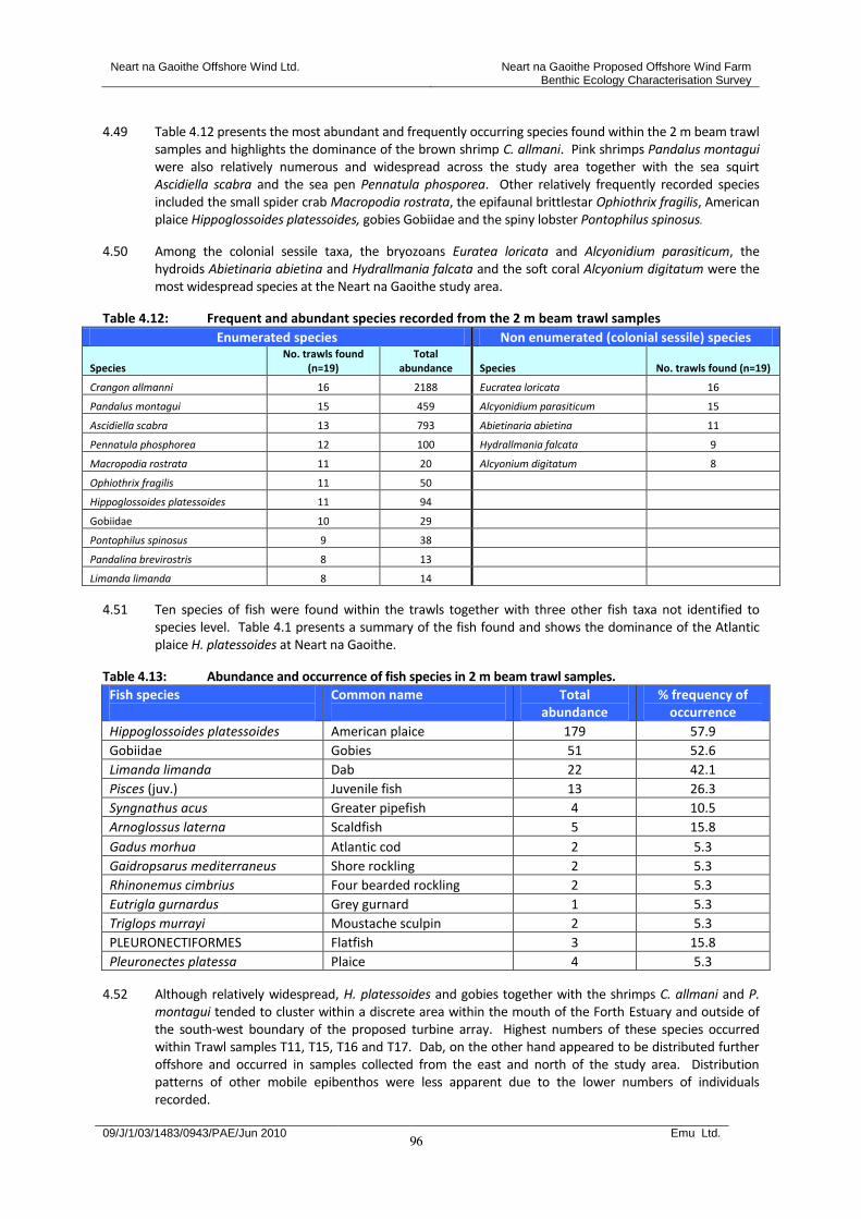
Neart na Gaoithe Offshore Wind Ltd. Neart na Gaoithe Proposed Offshore Wind Farm Benthic Ecology Characterisation Survey
09/J/1/03/1483/0943/PAE/Jun 2010 Emu Ltd.
96
4.49 Table 4.12 presents the most abundant and frequently occurring species found within the 2 m beam trawl samples and highlights the dominance of the brown shrimp C. allmani. Pink shrimps Pandalus montagui were also relatively numerous and widespread across the study area together with the sea squirt Ascidiella scabra and the sea pen Pennatula phosporea. Other relatively frequently recorded species included the small spider crab Macropodia rostrata, the epifaunal brittlestar Ophiothrix fragilis, American plaice Hippoglossoides platessoides, gobies Gobiidae and the spiny lobster Pontophilus spinosus.
4.50 Among the colonial sessile taxa, the bryozoans Euratea loricata and Alcyonidium parasiticum, the hydroids Abietinaria abietina and Hydrallmania falcata and the soft coral Alcyonium digitatum were the most widespread species at the Neart na Gaoithe study area.
Table 4.12: Frequent and abundant species recorded from the 2 m beam trawl samples
Enumerated species Non enumerated (colonial sessile) species
Species No. trawls found
(n=19) Total
abundance Species No. trawls found (n=19)
Crangon allmanni 16 2188 Eucratea loricata 16
Pandalus montagui 15 459 Alcyonidium parasiticum 15
Ascidiella scabra 13 793 Abietinaria abietina 11
Pennatula phosphorea 12 100 Hydrallmania falcata 9
Macropodia rostrata 11 20 Alcyonium digitatum 8
Ophiothrix fragilis 11 50
Hippoglossoides platessoides 11 94
Gobiidae 10 29
Pontophilus spinosus 9 38
Pandalina brevirostris 8 13
Limanda limanda 8 14
4.51 Ten species of fish were found within the trawls together with three other fish taxa not identified to species level. Table 4.1 presents a summary of the fish found and shows the dominance of the Atlantic plaice H. platessoides at Neart na Gaoithe.
Table 4.13: Abundance and occurrence of fish species in 2 m beam trawl samples.
Fish species
Common name
Total abundance
% frequency of occurrence
Hippoglossoides platessoides American plaice 179 57.9
Gobiidae Gobies 51 52.6
Limanda limanda Dab 22 42.1
Pisces (juv.) Juvenile fish 13 26.3
Syngnathus acus Greater pipefish 4 10.5
Arnoglossus laterna Scaldfish 5 15.8
Gadus morhua Atlantic cod 2 5.3
Gaidropsarus mediterraneus Shore rockling 2 5.3
Rhinonemus cimbrius Four bearded rockling 2 5.3
Eutrigla gurnardus Grey gurnard 1 5.3
Triglops murrayi Moustache sculpin 2 5.3
PLEURONECTIFORMES Flatfish 3 15.8
Pleuronectes platessa Plaice 4 5.3
4.52 Although relatively widespread, H. platessoides and gobies together with the shrimps C. allmani and P. montagui tended to cluster within a discrete area within the mouth of the Forth Estuary and outside of the south-west boundary of the proposed turbine array. Highest numbers of these species occurred within Trawl samples T11, T15, T16 and T17. Dab, on the other hand appeared to be distributed further offshore and occurred in samples collected from the east and north of the study area. Distribution patterns of other mobile epibenthos were less apparent due to the lower numbers of individuals recorded.
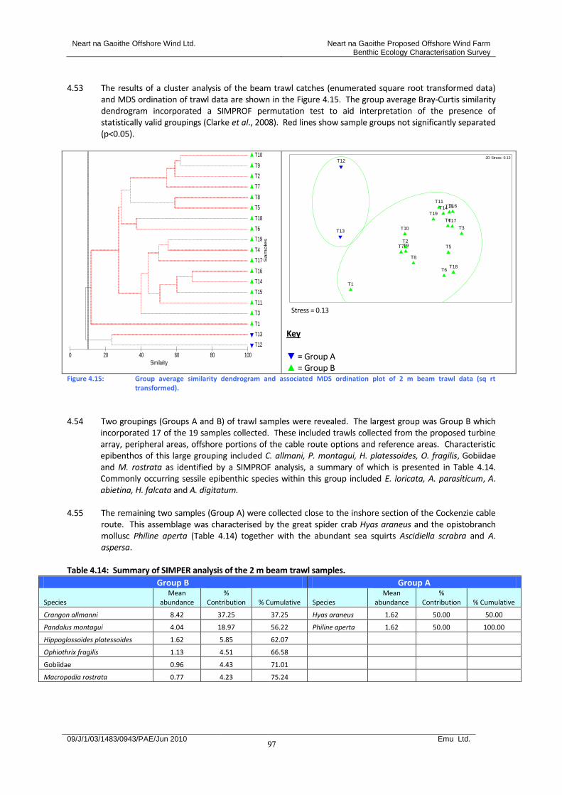
Neart na Gaoithe Offshore Wind Ltd. Neart na Gaoithe Proposed Offshore Wind Farm Benthic Ecology Characterisation Survey
09/J/1/03/1483/0943/PAE/Jun 2010 Emu Ltd.
97
4.53 The results of a cluster analysis of the beam trawl catches (enumerated square root transformed data)
and MDS ordination of trawl data are shown in the Figure 4.15. The group average Bray-Curtis similarity dendrogram incorporated a SIMPROF permutation test to aid interpretation of the presence of statistically valid groupings (Clarke et al., 2008). Red lines show sample groups not significantly separated (p<0.05).
T12
T13
T1
T3
T11
T15
T14
T16
T17
T4
T19
T6
T18
T5
T8
T7
T2
T9
T10
Sam
ple
s
100806040200
Similarity
T1
T2
T3
T4
T5
T6
T7
T8
T9
T10
T11
T12
T13
T14T15T16
T17
T18
T19
2D Stress: 0.13
Stress = 0.13
Key ▼ = Group A ▲ = Group B
Figure 4.15: Group average similarity dendrogram and associated MDS ordination plot of 2 m beam trawl data (sq rt transformed).
4.54 Two groupings (Groups A and B) of trawl samples were revealed. The largest group was Group B which
incorporated 17 of the 19 samples collected. These included trawls collected from the proposed turbine array, peripheral areas, offshore portions of the cable route options and reference areas. Characteristic epibenthos of this large grouping included C. allmani, P. montagui, H. platessoides, O. fragilis, Gobiidae and M. rostrata as identified by a SIMPROF analysis, a summary of which is presented in Table 4.14. Commonly occurring sessile epibenthic species within this group included E. loricata, A. parasiticum, A. abietina, H. falcata and A. digitatum.
4.55 The remaining two samples (Group A) were collected close to the inshore section of the Cockenzie cable
route. This assemblage was characterised by the great spider crab Hyas araneus and the opistobranch mollusc Philine aperta (Table 4.14) together with the abundant sea squirts Ascidiella scrabra and A. aspersa.
Table 4.14: Summary of SIMPER analysis of the 2 m beam trawl samples.
Group B Group A
Species Mean
abundance %
Contribution % Cumulative Species Mean
abundance %
Contribution % Cumulative
Crangon allmanni 8.42 37.25 37.25 Hyas araneus 1.62 50.00 50.00
Pandalus montagui 4.04 18.97 56.22 Philine aperta 1.62 50.00 100.00
Hippoglossoides platessoides 1.62 5.85 62.07
Ophiothrix fragilis 1.13 4.51 66.58
Gobiidae 0.96 4.43 71.01
Macropodia rostrata 0.77 4.23 75.24
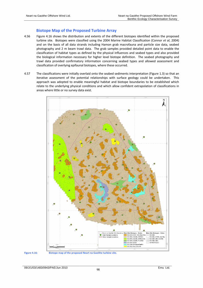
Neart na Gaoithe Offshore Wind Ltd. Neart na Gaoithe Proposed Offshore Wind Farm Benthic Ecology Characterisation Survey
09/J/1/03/1483/0943/PAE/Jun 2010 Emu Ltd.
98
Biotope Map of the Proposed Turbine Array 4.56 Figure 4.16 shows the distribution and extents of the different biotopes identified within the proposed
turbine site. Biotopes were classified using the 2004 Marine Habitat Classification (Connor et al, 2004) and on the basis of all data strands including Hamon grab macrofauna and particle size data, seabed photography and 2 m beam trawl data. The grab samples provided detailed point data to enable the classification of habitat types as defined by the physical influences and seabed types and also provided the biological information necessary for higher level biotope definition. The seabed photography and trawl data provided confirmatory information concerning seabed types and allowed assessment and classification of overlying epifaunal biotopes, where these occurred.
4.57 The classifications were initially overlaid onto the seabed sediments interpretation (Figure 1.3) so that an
iterative assessment of the potential relationships with surface geology could be undertaken. This approach was adopted to enable meaningful habitat and biotope boundaries to be established which relate to the underlying physical conditions and which allow confident extrapolation of classifications in areas where little or no survey data exist.
Figure 4.16: Biotope map of the proposed Neart na Gaoithe turbine site.
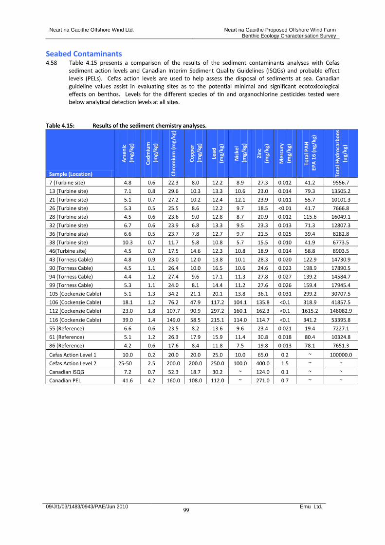
Neart na Gaoithe Offshore Wind Ltd. Neart na Gaoithe Proposed Offshore Wind Farm Benthic Ecology Characterisation Survey
09/J/1/03/1483/0943/PAE/Jun 2010 Emu Ltd.
99
Seabed Contaminants 4.58 Table 4.15 presents a comparison of the results of the sediment contaminants analyses with Cefas
sediment action levels and Canadian Interim Sediment Quality Guidelines (ISQGs) and probable effect levels (PELs). Cefas action levels are used to help assess the disposal of sediments at sea. Canadian guideline values assist in evaluating sites as to the potential minimal and significant ecotoxicological effects on benthos. Levels for the different species of tin and organochlorine pesticides tested were below analytical detection levels at all sites.
Table 4.15: Results of the sediment chemistry analyses.
Sample (Location)
Ars
en
ic
(m
g/kg
)
Cad
miu
m
(m
g/kg
)
Ch
rom
ium
(m
g/kg
)
Co
pp
er
(m
g/kg
)
Lead
(mg/
kg)
Nic
kel
(m
g/kg
)
Zin
c
(mg/
kg)
Me
rcu
ry
(mg/
kg)
Tota
l PA
H
EP
A 1
6 (
ng/
kg)
Tota
l Hyd
roca
rbo
ns
(ug/
kg)
7 (Turbine site) 4.8 0.6 22.3 8.0 12.2 8.9 27.3 0.012 41.2 9556.7
13 (Turbine site) 7.1 0.8 29.6 10.3 13.3 10.6 23.0 0.014 79.3 13505.2
21 (Turbine site) 5.1 0.7 27.2 10.2 12.4 12.1 23.9 0.011 55.7 10101.3
26 (Turbine site) 5.3 0.5 25.5 8.6 12.2 9.7 18.5 <0.01 41.7 7666.8
28 (Turbine site) 4.5 0.6 23.6 9.0 12.8 8.7 20.9 0.012 115.6 16049.1
32 (Turbine site) 6.7 0.6 23.9 6.8 13.3 9.5 23.3 0.013 71.3 12807.3
36 (Turbine site) 6.6 0.5 23.7 7.8 12.7 9.7 21.5 0.025 39.4 8282.8
38 (Turbine site) 10.3 0.7 11.7 5.8 10.8 5.7 15.5 0.010 41.9 6773.5
46(Turbine site) 4.5 0.7 17.5 14.6 12.3 10.8 18.9 0.014 58.8 8903.5
43 (Torness Cable) 4.8 0.9 23.0 12.0 13.8 10.1 28.3 0.020 122.9 14730.9
90 (Torness Cable) 4.5 1.1 26.4 10.0 16.5 10.6 24.6 0.023 198.9 17890.5
94 (Torness Cable) 4.4 1.2 27.4 9.6 17.1 11.3 27.8 0.027 139.2 14584.7
99 (Torness Cable) 5.3 1.1 24.0 8.1 14.4 11.2 27.6 0.026 159.4 17945.4
105 (Cockenzie Cable) 5.1 1.3 34.2 21.1 20.1 13.8 36.1 0.031 299.2 30707.5
106 (Cockenzie Cable) 18.1 1.2 76.2 47.9 117.2 104.1 135.8 <0.1 318.9 41857.5
112 (Cockenzie Cable) 23.0 1.8 107.7 90.9 297.2 160.1 162.3 <0.1 1615.2 148082.9
116 (Cockenzie Cable) 39.0 1.4 149.0 58.5 215.1 114.0 114.7 <0.1 341.2 53395.8
55 (Reference) 6.6 0.6 23.5 8.2 13.6 9.6 23.4 0.021 19.4 7227.1
61 (Reference) 5.1 1.2 26.3 17.9 15.9 11.4 30.8 0.018 80.4 10324.8
86 (Reference) 4.2 0.6 17.6 8.4 11.8 7.5 19.8 0.013 78.1 7651.3
Cefas Action Level 1 10.0 0.2 20.0 20.0 25.0 10.0 65.0 0.2 ~ 100000.0
Cefas Action Level 2 25-50 2.5 200.0 200.0 250.0 100.0 400.0 1.5 ~ ~
Canadian ISQG 7.2 0.7 52.3 18.7 30.2 ~ 124.0 0.1 ~ ~
Canadian PEL 41.6 4.2 160.0 108.0 112.0 ~ 271.0 0.7 ~ ~

Neart na Gaoithe Offshore Wind Ltd. Neart na Gaoithe Proposed Offshore Wind Farm Benthic Ecology Characterisation Survey
09/J/1/03/1483/0943/PAE/Jun 2010 Emu Ltd.
100
5 Discussion
5.1 This study has characterised the subtidal and intertidal benthic habitats and associated macrofaunal and macroalgal communities within the potential influences of the construction and operation of the proposed Neart na Gaoithe offshore wind farm. These data will inform the environmental impact assessment and subsequent Environmental Statement. The collection of quantitative data and subsequent analyses has shown that the sediments and biological communities at selected reference stations are representative of those within development area and local surrounds allowing the subsequent establishment of robust baseline and monitoring survey campaigns.
Subtidal Benthic Environment 5.2 Subtidal data supported a low energy, deep water (circalittoral) seabed environment within the
vicinity of the proposed Neart na Gaoithe offshore wind farm development. The dominant sediment type was slightly gravelly sand sediments with small amounts of silt and was characterised by typical mud and sand fauna comprising infaunal brittlestars, polychaetes and bivalves. Sea bed imagery revealed that this sand habitat was also associated with sea pens and prominent mounds and burrows produced by megafauna.
5.3 Although predominantly circalittoral sand, the species characterising the proposed wind farm site
including Nephrops norvegicus, Amphiura filiformis and the sea pens Pennatula phosphorea and Virgularia mirabilis corresponded with those usually associated with the UKBAP ‘mud habitat in deep water’. Indeed the dominant overlying SS.SMu.CSaMu.SpnMeg biotope classified during this study is a relevant biotope of this UKBAP habitat type (Maddock, 2008). MESH data, however, showed that this circalittoral sand habitat is very widespread throughout the wider region so that the wind farm development will only occupy a small part of the total circalittoral sand habitat type available. No significant loss of circalittoral sand with sea pens and megafauna habitat is therefore forecast as a result of the proposals.
5.4 The characteristic soft sediment fauna within and surrounding the proposed turbine array and cable
route options are expected to be tolerant to fine sediment deposition given their natural sediment dwelling habit. Consequently, no significant adverse effects on the dominant sediment communities as a result of seabed sediment disturbances and re-deposition during construction of the wind farm are forecast.
5.5 Patches of mixed muddy coarse sediment, cobbles and boulders representing exposed Wee Bankie
formation supported a variety of typical attaching and encrusting species including soft corals, bryozoans, hydroids, calcareous tube worms, anemones and barnacles. The upper surfaces of cobbles and boulders supported dense populations of the epifaunal brittlestar Ophiothrix fragilis where presumably the presence of relatively stronger tidal current streams facilitates filter feeding. The squat lobster Munida rugosa was also frequently observed sheltering under larger stones, cobbles and boulders. Habitats were locally very variable and these hard mixed substrates are likely to represent a mosaic of biotopes.
5.6 It is likely that the mixed hard substrata communities at Neart na Gaoithe are tolerant to a degree of
temporary fine sediment deposition, although sessile colonial epibenthic components may be comparatively sensitive to this effect as a result of potential damage to feeding and respiratory apparatus. Recovery of local sessile epibenthic fauna is however, likely to be relatively quick (within months) and will proceed as soon as the disturbance has abated so that long term adverse effects are not anticipated in this regard.
5.7 The mobile epibenthic assemblages recorded during the current trawl sampling were found to be
more characteristic of the southern North Sea but nevertheless concur with the findings of historic surveys in the area (Calloway et al., 2002 & Jennings et al., 1999). Calloway et al. for example also regularly recorded American plaice and dab in 2 m beam trawls and regarded these as characteristic of the general area. Also, both Jennings et al. and Calloway et al. together with Dyer et al. (1983) also found a distinct North Sea assemblage represented in part by increasing dominance of Crangon
Neart na Gaoithe Offshore Wind Ltd. Neart na Gaoithe Proposed Offshore Wind Farm Benthic Ecology Characterisation Survey
09/J/1/03/1483/0943/PAE/Jun 2010 Emu Ltd.
101
allmanni and Anapagurus laevis. A. laevis was the dominant hermit crab from the current trawl survey.
5.8 No rare or protected benthic species were recorded from the grab, trawl and video studies. Although
associated with the SpnMeg biotope, the nationally scarce sea pen species Funiculina quadrangularis is absent from the Forth Estuary due to a combination of adverse sediment and water depth characteristics (Greathead et al, 2007).
5.9 Sediment contaminants within the proposed turbine array and along the Torness cable route were
present at levels below Cefas sediment action levels and Canadian Interim Sediment Quality Guidelines. Therefore no significant adverse effects of the re-distribution of contaminated sediments on benthic fauna anticipated as a result of proposed development of the turbine array and Torness cable route. Levels at inshore locations along the Cockenzie cable route however exceeded guideline values (i.e. hydrocarbons and lead) and may reflect the industrial heritage of the Forth Estuary and associated seabed influences.
5.10 Fishing activity in the area, as evidenced by dense static fishing gears along the proposed Thorntonloch
cable route and seabed scars probably from demersal fishing gears within the turbine array will be addressed within the ES.
Intertidal Environment
Cockenzie Intertidal Site 5.11 Cockenzie is encompassed within the Forth Estuary Special Protection Area (SPA), part of the Natura
2000 sites designated under the Birds Directive (79/409/EEC) (JNCC, 2009b; Magic Maps, 2009). Areas are classified as SPAs where they support significant numbers of wild birds and their habitats. The Forth Estuary supports abundant wildfowl and waders and is particularly important for its wintering bird species. It is the second most important estuarine area for wintering birds in Scotland, and eleventh in the UK, and is significant both in terms of waterfowl density and abundance (Registers of Scotland, 2009).
5.12 In addition, Cockenzie is within the Forth Estuary Ramsar site, designated under the Ramsar
Convention as a Wetland of International Importance (Magic Maps, 2009). The Firth of Forth area has also been designated as a Site of Special Scientific Interest (SSSI) for both its geology and coastal habitats and is afforded legal protection under the Wildlife and Countryside Act 1981 (Magic Maps, 2009; Registers of Scotland, 2009).
Thorntonloch Intertidal Site 5.13 The area surveyed is an ‘EC Identified Bathing Beach’ under the Bathing Water Directive (2006/7/EC)
(SEPA, 2009).
Skateraw Intertidal Site 5.14 Skateraw is encompassed within the Barns Ness SSSI, designated for both its geology and coastal
habitats, including shingle and sandy shores, sand dunes and a large area of mineral enriched grassland (Magic Maps, 2009; Registers of Scotland, 2009). SSSI’s are legally protected under the Wildlife and Countryside Act 1981.
Importance of intertidal biotopes within the survey areas 5.15 Three potentially important biotope types were observed within the landfall sites surveyed:
The blue mussel, Mytilus edulis, beds on mixed substrata (LS.LBR.LMus.Myt.Mx) - Priority habitat for conservation action under the UK Biodiversity Action Plan (BAP) (Maddock,
2008). - Biogenic reefs, including mussel beds, are listed in Annex I of the EC Habitats Directive as a
Habitat of International Conservation Importance (Council Directive EEC/92/43 on the
Neart na Gaoithe Offshore Wind Ltd. Neart na Gaoithe Proposed Offshore Wind Farm Benthic Ecology Characterisation Survey
09/J/1/03/1483/0943/PAE/Jun 2010 Emu Ltd.
102
Conservation of Natural Habitats and Wild Fauna and Flora). Annex I biogenic reefs are usually subtidal, intertidal mussel beds are only included within this Annex I reef type where they are connected to a subtidal reef (JNCC, 2009a).
Pebble/cobble/boulder aggregations - Rocky reefs are an Annex I habitat under the EC Habitats Directive as a Habitat of International
Conservation Importance (Council Directive EEC/92/43 on the Conservation of Natural Habitats and Wild Fauna and Flora). As with intertidal biogenic reefs, Annex I rocky reefs are generally subtidal and for an intertidal area to qualify the rocky aggregation needs to be connected to a sublittoral reef (JNCC, 2009a).
Under-boulder communities - Intertidal boulders with diverse under-boulder communities are listed as priority habitats for
conservation under the UK Biodiversity Action Plan (Maddock, 2008). 5.16 A pre-construction baseline intertidal survey, including to Phase II level, should be conducted at the
final preferred cable landfall site to confirm biodiversity and conservation interest.
Location of important biotopes within all intertidal sites
Cockenzie
Mytilus edulis beds on mixed substrata in the lower shore – ‘blue mussel bed on sediment’ BAP habitat. Occurs within a distinct zone that ends above the Chondrus crispus zone bordering the infralittoral kelp area, therefore may not qualify as an Annex I biogenic reef.
Extensive pebble/cobble/boulder aggregations from the upper mid shore down to the infralittoral – potential Annex I rocky reef habitat.
Boulders within the upper midshore to the infralittoral – potential ‘intertidal under-boulder communities’ BAP habitat.
Thorntonloch
Numerous areas of cobbles and boulder outcrops extending down to the infralittoral kelp zone – potential Annex 1 rocky reef habitat.
Potential ‘intertidal under-boulder communities’ BAP habitat.
Skateraw
Mytilus edulis beds on mixed substrata south of the central water channel extending down to the low shore – ‘blue mussel bed on sediment’ BAP habitat. The mussel beds in this area were not usually more than one animal thick and did not form any significant raised area, they are therefore unlikely to be classified as a biogenic reef and afforded protection as an Annex I habitat.
Pebble/cobble/boulder area with kelp cover – potential Annex I rocky reef.
Scattered large boulders and boulder/cobble areas – potential ‘intertidal under-boulder communities’ BAP habitat.
Neart na Gaoithe Offshore Wind Ltd. Neart na Gaoithe Proposed Offshore Wind Farm Benthic Ecology Characterisation Survey
09/J/1/03/1483/0943/PAE/Jun 2010 Emu Ltd.
103
6 Conclusions
6.1 This study has provided a characterisation of the seabed habitats and biological communities within the vicinity of the Neart na Gaoithe offshore wind farm proposals. The data will inform the environmental impact assessment and ES to accompany the development application.
6.2 No rare or protected species were found and habitats were typical of the wider region. 6.3 Potential UKBAP ‘mud habitat in deep water’ habitat within the proposed turbine array and along the
cable route options was found to be typical of the wider region and no significant effect on the regional availability of this habitat type is likely as a result of the proposals.
6.4 Important intertidal habitats (‘blue mussel bed on sediment’, ‘intertidal under-boulder communities’ and
‘pebble, cobble and boulder aggregations’ were similarly widespread throughout the wider region and were represented at all coastal sites studied. Again, no significant effect on the regional availability of this habitat type is likely as a result of the proposals.
6.5 No benthic ecological constraints to development have been identified as a result of this study but this
will be subject to a detailed assessment within the ES. The presence of static fishing gears close inshore along the Thorntonloch cable route and evidence of demersal trawling from side scan sonar records should be addressed within the consideration of commercial fisheries issues within the ES.
Neart na Gaoithe Offshore Wind Ltd. Neart na Gaoithe Proposed Offshore Wind Farm Benthic Ecology Characterisation Survey
09/J/1/03/1483/0943/PAE/Jun 2010 Emu Ltd.
104
7 References
Bolton, T. F., and Havenhand, J. N. (1996). Chemical Mediation of Sperm Activity and Longevity in the Solitary Ascidians Ciona intestinalis and Ascidiella aspersa. Biol. Bull. 190: 329-335. (June, 1996). Callaway, R., Alsvag, J., de Boois, I., Cotter, J., Ford, A., Hinz, H., Jennings, S., Kröncke, I., Lancaster, J., Piet, G., Prince, P., and Ehrich, S (2002). Diversity and community structure of epibenthic invertebrates and fish in the North Sea. – ICES Journal of Marine Science, 59: 1199–1214. Clarke, K. R & Gorley, R. N. (2006). PRIMER v6: User Manual/Tutorial. PRIMER-E: Plymouth. Clarke, K. R & Warwick, R. M. (2001). Change in Marine Communities: An Approach to Statistical Analysis and Interpretation. Second Edition. PRIMER-E: Plymouth. Connor DW, Allen JH, Golding N, Howell KL, Lieberknecht LM, Northern KO & Reker JB. (2004). The Marine Habitat Classification for Britain and Ireland, Version 04.05. Joint Nature Conservation Committee. Davies J, Baxter J, Bradley M, Connor D, Khan J, Murray E, Sanderson W, Turnbull C & Vincent M. (2001). Marine Monitoring Handbook. Joint Nature Conservation Committee. Dyer M.F., Fry W.G., Fry P.D. & Cranmer G.J. (1983). Benthic Regions Within the North Sea. J. Mar. Biol. Ass. U.K. 63, 683-693. Eleftheriou, A. & Basford, D.J. (1989). The Macrobenthic Fauna of the Offshore Northern North Sea. J. Mar. Biol 69, 123-143. Eleftheriou, A., Basford D & Moore, D.C. (2004). Synthesis of Information on the Benthos of Area SEA 5. Report for the Department of Trade and Industry. Final Draft 1 May 2004. Emu Ltd, (2010). Neart na Gaoithe Proposed Offshore Wind Farm and Cable Routes Geophysical Survey. Report to Neart na Gaoithe Offshore Wind Limited. Report No. 09/J/1/02/1447/0917. January 2010.
Folk, R.L., 1954. The distinction between grain size and mineral composition in sedimentary rock nomenclature. Journal of Geology 62 (4), 344-359. Glémarec, M. (1973). The benthic communities of the European north Atlantic continental shelf. Oceangr, Mar. Biol. Ann. Rev. 11, 263-289. Gofas, S. (2009). Abra alba (Wood W., 1802). In: Bouchet, P.; Gofas, S.; Rosenberg, G. (2009) World Marine Mollusca database. Accessed through the World Register of Marine Species at http://www.marinespecies.org/aphia.php?p=taxdetails&id=141433 on 2009-12-17. Greathead, C.F., Donnan, D.W., Mair, J.M. & Saunders, G.R (2007). The seapens Virgularia mirabilis, Pennatula phosphorea and Funiculina quadrangularis: distribution and conservation issues in Scottish waters. Hiscock, K. ed. (1996). Marine Nature Conservation review: rationale and methods. Peterborough, Joint Nature Conservation Committee. (Coasts and seas of the United Kingdom, MNCR series). Jennings, S., J. Lancaster, A. Woolmer & J. Cotter (1999). Distribution, diversity and abundance of epibenthic fauna in the North Sea. J. Mar. Biol. Assoc. UK 79: 385-399. Moore, C., Edwards, D.C.B., Harries, D.B. & Lyndon, A.R. (2009). The establishment of site condition monitoring of the rocky reefs of the Isle of May Special Area of Conservation. Scottish Natural Heritage Commissioned Report No. 301 (ROAME No. R07AC705).
Neart na Gaoithe Offshore Wind Ltd. Neart na Gaoithe Proposed Offshore Wind Farm Benthic Ecology Characterisation Survey
09/J/1/03/1483/0943/PAE/Jun 2010 Emu Ltd.
105
Maddock, A. (2008 ed). UK Biodiversity Action Plan: priority habitat descriptions. BRIG available from www.ukbap.org.uk. Posford Haskoning (2002) Broad scale intertidal survey of the Firth of Forth. Scottish Natural Heritage Commissioned Report F01AA407. Rees, H.L., Pendle, M.A., Waldock, R., Limpenny, D.S. & Boyd, S.E. (1999). A Comparison of Benthic Biodiversity in the North Sea, English Channel and Celtic Seas. ICES Jour Mar Sci, 56: 228-246. Sanderson, W.G. (1996). Rare marine benthic flora and fauna in Great Britain: the development of criteria for assessment. JNCC (report no. 240). Peterborough. Tebble, N. (1966). British Bivalve Seashells. A Handbook for Identification. British Museum (Natural History). 212 pp. WEBSITES: Scottish Environment Protection Agency (2009). http://www.sepa.org.uk/water/protected_areas.aspx Register of protected areas in Scotland Visited 13-11-09. Joint Nature Conservation Council (2009a). http://www.jncc.gov.uk/protectedsites/SACselection/habitat.asp?featureIntcode=H1170 Protected sites information Visited 27-11-09, 30-11-09. URL – Joint Nature Conservation Council (2009b). http://www.jncc.gov.uk/default.aspx?page=1979 Firth of Forth SPA information Visited 13-11-09. de Kluijver M.J. & Ingalsuo S.S. Macrobenthos of the North Sea – Crustacea. Online version, Species-Identification Portal: http://species-identification.org/species.php?species_group=crustacea&id=210 [Accessed 10th December 2009]. Picton, B.E. & Morrow, C.C., (2007a). [In] Encyclopedia of Marine Life of Britain and Ireland, http://www.habitas.org.uk/marinelife/species.asp?item=ZD1410 [Accessed 10th December 2009]. Picton, B.E. & Morrow, C.C., (2007b). [In] Encyclopedia of Marine Life of Britain and Ireland http://www.habitas.org.uk/marinelife/species.asp?item=ZB2850 [Accessed 10th December 2009]. Global Invasive Species Database. (2005). Ascidiella aspersa. Available from: http://www.issg.org/database/species/ecology.asp?si=1126&fr=1&sts=&lang=EN [Accessed 10th December 2009]. Whitehead, P.J.P., Bauchot, M.-L., Hureau, J.-C., Nielsen, J. and Tortonese, E. (Eds.). (1984/1986/1989). Fishes of the North-eastern Atlantic and the Mediterranean. UNESCO, Paris Online version, Species-Identification Portal: http://species-identification.org/species.php?species_group=fnam&id=2141 [Accessed 10th December 2009].
APPENDICES
CD available on request