Belleville Upper Pond Inlet · RHODE ISLAND STATEWIDE TMDL FOR BACTERIA IMPAIRED WATERS SEPTEMBER...
13
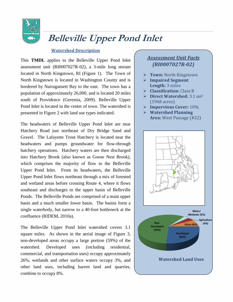
Assessment Unit Facts (RI0007027R-02) Town: North Kingstown Impaired Segment Length: 3 miles Classification: Class B Direct Watershed: 3.1 mi 2 (1968 acres) Impervious Cover: 10% Watershed Planning Area: West Passage (#22) Watershed Land Uses Developed (26%) Non- Developed (59%) Water/ Wetlands (3%) Agriculture (4%) Other (8%) Watershed Description This TMDL applies to the Belleville Upper Pond Inlet assessment unit (RI0007027R-02), a 3-mile long stream located in North Kingstown, RI (Figure 1). The Town of North Kingstown is located in Washington County and is bordered by Narragansett Bay to the east. The town has a population of approximately 26,000, and is located 20 miles south of Providence (Geremia, 2009). Belleville Upper Pond Inlet is located in the center of town. The watershed is presented in Figure 2 with land use types indicated. The headwaters of Belleville Upper Pond Inlet are near Hatchery Road just northeast of Dry Bridge Sand and Gravel. The Lafayette Trout Hatchery is located near the headwaters and pumps groundwater for flow-through hatchery operations. Hatchery waters are then discharged into Hatchery Brook (also known as Goose Nest Brook), which comprises the majority of flow to the Belleville Upper Pond Inlet. From its headwaters, the Belleville Upper Pond Inlet flows northeast through a mix of forested and wetland areas before crossing Route 4, where it flows southeast and discharges to the upper basin of Belleville Ponds. The Belleville Ponds are comprised of a main upper basin and a much smaller lower basin. The basins form a single waterbody, but narrow to a 40-foot bottleneck at the confluence (RIDEM, 2010a). The Belleville Upper Pond Inlet watershed covers 3.1 square miles. As shown in the aerial image of Figure 3, non-developed areas occupy a large portion (59%) of the watershed. Developed uses (including residential, commercial, and transportation uses) occupy approximately 26%, wetlands and other surface waters occupy 3%, and other land uses, including barren land and quarries, combine to occupy 8%. Belleville Upper Pond Inlet
Transcript of Belleville Upper Pond Inlet · RHODE ISLAND STATEWIDE TMDL FOR BACTERIA IMPAIRED WATERS SEPTEMBER...
Assessment Unit Facts (RI0007027R-02)
Town: North Kingstown Impaired Segment
Length: 3 miles Classification: Class B Direct Watershed: 3.1 mi2
(1968 acres) Impervious Cover: 10% Watershed Planning
Area: West Passage (#22)
Watershed Land Uses
Developed (26%)
Non-Developed
(59%)
Water/Wetlands (3%)
Agriculture (4%)Other (8%)
Watershed Description
This TMDL applies to the Belleville Upper Pond Inlet
assessment unit (RI0007027R-02), a 3-mile long stream
located in North Kingstown, RI (Figure 1). The Town of
North Kingstown is located in Washington County and is
bordered by Narragansett Bay to the east. The town has a
population of approximately 26,000, and is located 20 miles
south of Providence (Geremia, 2009). Belleville Upper
Pond Inlet is located in the center of town. The watershed is
presented in Figure 2 with land use types indicated.
The headwaters of Belleville Upper Pond Inlet are near
Hatchery Road just northeast of Dry Bridge Sand and
Gravel. The Lafayette Trout Hatchery is located near the
headwaters and pumps groundwater for flow-through
hatchery operations. Hatchery waters are then discharged
into Hatchery Brook (also known as Goose Nest Brook),
which comprises the majority of flow to the Belleville
Upper Pond Inlet. From its headwaters, the Belleville
Upper Pond Inlet flows northeast through a mix of forested
and wetland areas before crossing Route 4, where it flows
southeast and discharges to the upper basin of Belleville
Ponds. The Belleville Ponds are comprised of a main upper
basin and a much smaller lower basin. The basins form a
single waterbody, but narrow to a 40-foot bottleneck at the
confluence (RIDEM, 2010a).
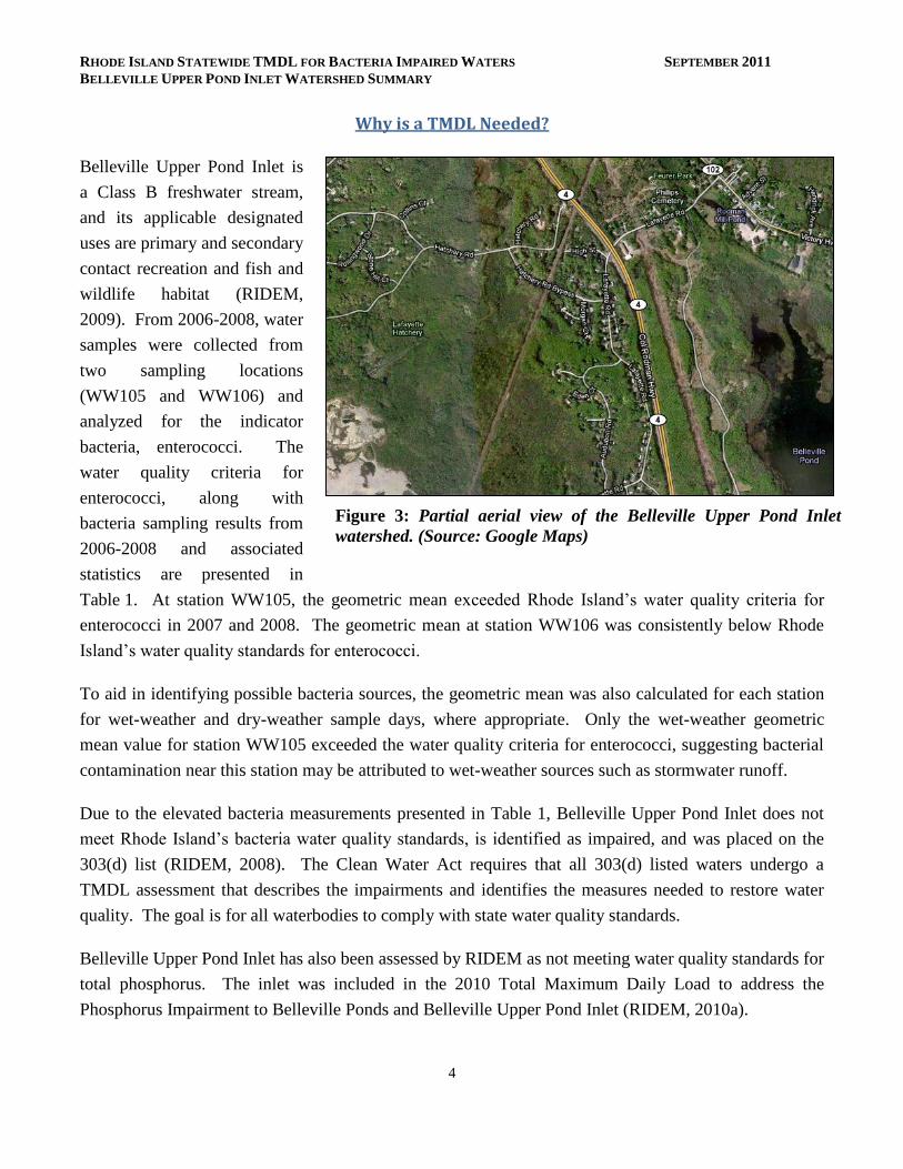
The Belleville Upper Pond Inlet watershed covers 3.1
square miles. As shown in the aerial image of Figure 3,
non-developed areas occupy a large portion (59%) of the
watershed. Developed uses (including residential,
commercial, and transportation uses) occupy approximately
26%, wetlands and other surface waters occupy 3%, and
other land uses, including barren land and quarries,
combine to occupy 8%.
Belleville Upper Pond Inlet
RHODE ISLAND STATEWIDE TMDL FOR BACTERIA IMPAIRED WATERS SEPTEMBER 2011
BELLEVILLE UPPER POND INLET WATERSHED SUMMARY
2
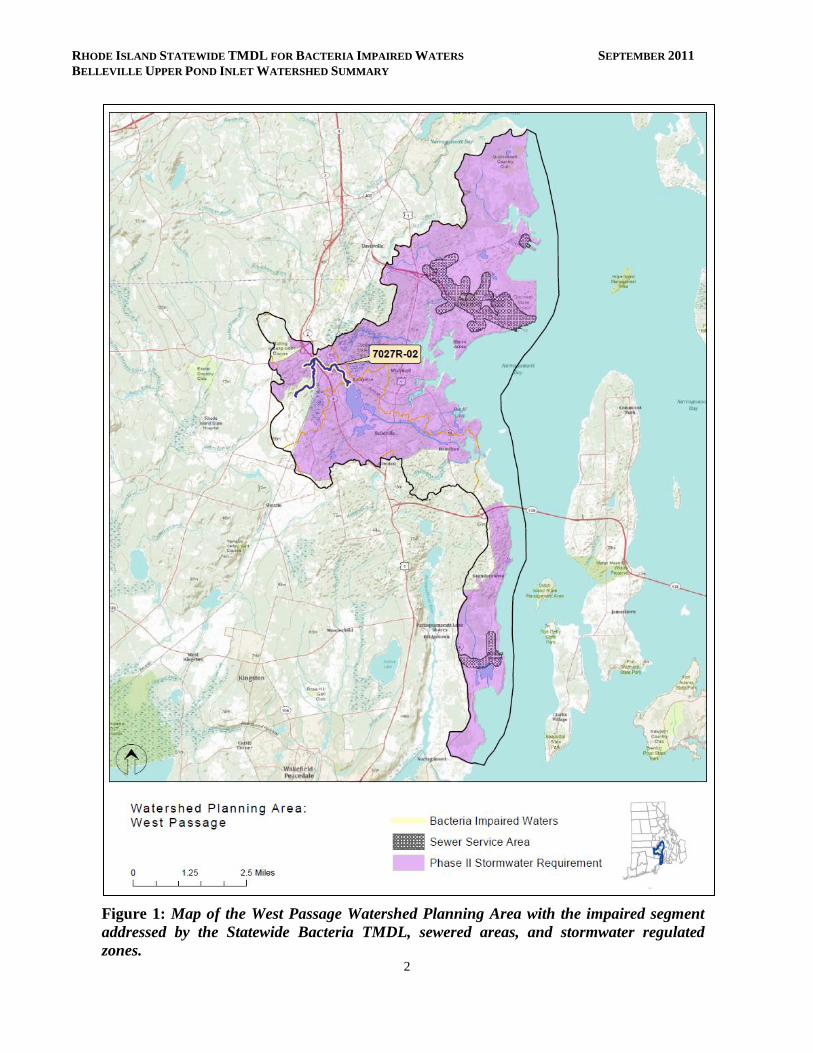
Figure 1: Map of the West Passage Watershed Planning Area with the impaired segment
addressed by the Statewide Bacteria TMDL, sewered areas, and stormwater regulated
zones.
RHODE ISLAND STATEWIDE TMDL FOR BACTERIA IMPAIRED WATERS SEPTEMBER 2011
BELLEVILLE UPPER POND INLET WATERSHED SUMMARY
3
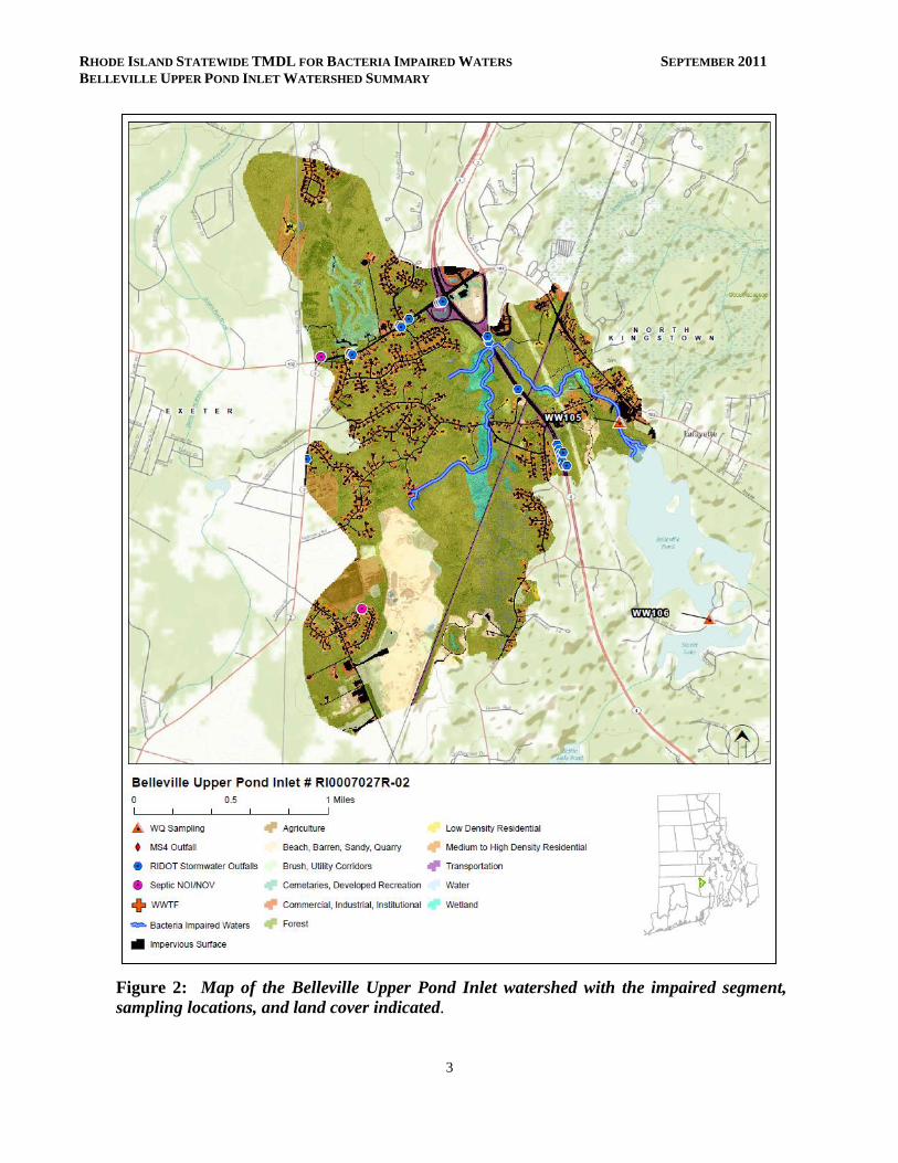
Figure 2: Map of the Belleville Upper Pond Inlet watershed with the impaired segment,
sampling locations, and land cover indicated.
RHODE ISLAND STATEWIDE TMDL FOR BACTERIA IMPAIRED WATERS SEPTEMBER 2011
BELLEVILLE UPPER POND INLET WATERSHED SUMMARY
4
Figure 3: Partial aerial view of the Belleville Upper Pond Inlet
watershed. (Source: Google Maps)
Why is a TMDL Needed?
Belleville Upper Pond Inlet is
a Class B freshwater stream,
and its applicable designated
uses are primary and secondary
contact recreation and fish and
wildlife habitat (RIDEM,
2009). From 2006-2008, water
samples were collected from
two sampling locations
(WW105 and WW106) and
analyzed for the indicator
bacteria, enterococci. The
water quality criteria for
enterococci, along with
bacteria sampling results from
2006-2008 and associated
statistics are presented in
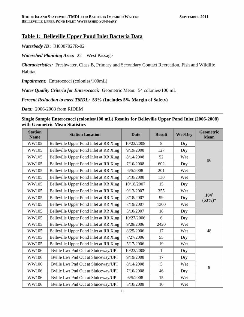
Table 1. At station WW105, the geometric mean exceeded Rhode Island’s water quality criteria for
enterococci in 2007 and 2008. The geometric mean at station WW106 was consistently below Rhode
Island’s water quality standards for enterococci.
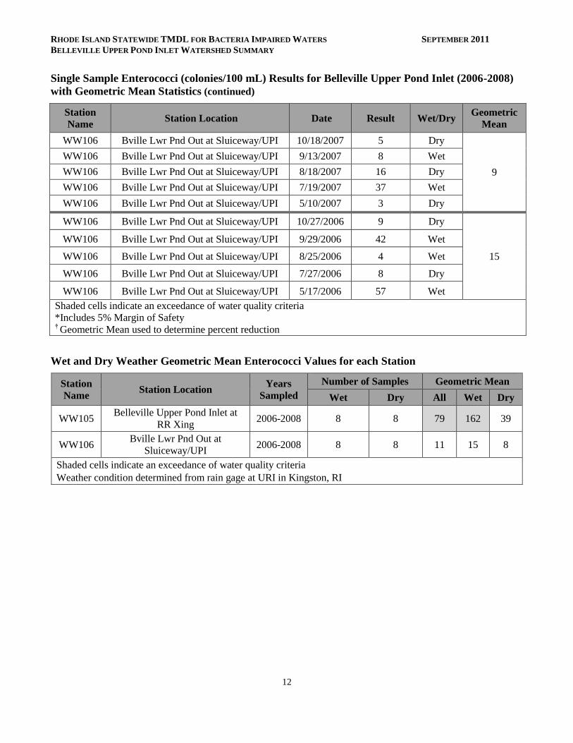
To aid in identifying possible bacteria sources, the geometric mean was also calculated for each station
for wet-weather and dry-weather sample days, where appropriate. Only the wet-weather geometric
mean value for station WW105 exceeded the water quality criteria for enterococci, suggesting bacterial
contamination near this station may be attributed to wet-weather sources such as stormwater runoff.
Due to the elevated bacteria measurements presented in Table 1, Belleville Upper Pond Inlet does not
meet Rhode Island’s bacteria water quality standards, is identified as impaired, and was placed on the
303(d) list (RIDEM, 2008). The Clean Water Act requires that all 303(d) listed waters undergo a
TMDL assessment that describes the impairments and identifies the measures needed to restore water
quality. The goal is for all waterbodies to comply with state water quality standards.
Belleville Upper Pond Inlet has also been assessed by RIDEM as not meeting water quality standards for
total phosphorus. The inlet was included in the 2010 Total Maximum Daily Load to address the
Phosphorus Impairment to Belleville Ponds and Belleville Upper Pond Inlet (RIDEM, 2010a).
RHODE ISLAND STATEWIDE TMDL FOR BACTERIA IMPAIRED WATERS SEPTEMBER 2011
BELLEVILLE UPPER POND INLET WATERSHED SUMMARY
5
Potential Bacteria Sources
There are several potential sources of bacteria in the Belleville Upper Pond Inlet watershed including
stormwater runoff from developed areas, malfunctioning septic systems, and wildlife and domestic
animal waste.
Lafayette Trout Hatchery
The Lafayette Trout Hatchery, a state facility, is the only non-stormwater point source within the
Belleville Upper Pond Inlet watershed. The facility pumps groundwater for flow-through hatchery
operations. Hatchery waters are then discharged into Hatchery Brook (a/k/a Goose Nest Brook), which
forms the Belleville Upper Pond Inlet. The mean daily flow from the facility, during the period of
September 2006 to June 2009, was 1.82 MGD. This hatchery discharge flow comprises the vast
majority of flow to the headwaters of the Belleville Upper Pond Inlet. The Belleville Upper Pond Inlet
discharges into the upper basin of Belleville Ponds approximately 3 km downstream of the Lafayette
Trout Hatchery. The RIDEM RIPDES (Rhode Island Pollutant Discharge Elimination System) program
has issued a permit regulating the hatchery’s effluent (RIPDES permit RI0110035). The hatchery’s
RIPDES permit requires that the hatchery discharge be sampled for total phosphorus and several other
pollutants (RIDEM, 2010a). Since the activities conducted at the hatchery (e.g., the farming of trout to
stock Rhode Island ponds and rivers) are not reasonably believed to contribute enterococci bacteria to its
discharge, the hatchery does not have bacteria sampling requirements and will not be further considered
as a source at this time.
Developed Area Stormwater Runoff
The Belleville Upper Pond Inlet watershed has an impervious cover of 10.2%. Impervious cover is
defined as land surface areas, such as roofs and roads that force water to run off land surfaces, rather
than infiltrating into the soil. Impervious cover provides a useful metric for the potential for adverse
stormwater impacts. As discussed in Section 6.3 of the Core TMDL Document, as a general rule,
impaired streams with watersheds having higher than 10% impervious cover are assumed to be affected
by urban stormwater runoff.
The Town of North Kingstown has identified and mapped 452 stormwater outfalls and their receiving
waterbodies (VHB, 2004). The town is continuing to update the map and identify other outfalls. As
shown in Figure 2, the Rhode Island Department of Transportation (RIDOT) has also identified multiple
stormwater outfalls in the watershed. Three areas of concentrated surface flow associated with highway
and residential runoff have also been identified on Hatchery Road at the Belleville Upper Pond Inlet
Bridge (RIDEM, 2010a).
RHODE ISLAND STATEWIDE TMDL FOR BACTERIA IMPAIRED WATERS SEPTEMBER 2011
BELLEVILLE UPPER POND INLET WATERSHED SUMMARY
6
Waterfowl, Wildlife, and Domestic Animal Waste
Wildlife, including waterfowl, may be a significant bacteria source to surface waters. With the
construction of roads and drainage systems, these wastes may no longer be retained on the landscape,
but instead may be conveyed via stormwater to the nearest surface water. As such these physical land
alterations can exacerbate the impact of these natural sources on water quality. The Belleville Upper
Pond Inlet watershed is predominately non-developed. A large wetland area adjacent to Route 4 is
home to multiple species of wildlife and waterfowl that may contribute bacteria through their waste
directly to the river. Canada geese have been observed congregating at a small impoundment to the east
of Lafayette Road. Grassed areas on both sides of the impoundment offer easy access to the water at this
location (RIDEM, 2010a). The western portion of the watershed is characterized by residential
development. Waste from domestic animals such as dogs, may also be contributing to bacteria
concentrations in Belleville Upper Pond Inlet.
Onsite Wastewater Treatment Systems
Approximately 96% of the Town of North Kingstown relies on onsite wastewater treatment systems
(OWTS) such as cesspools and septic systems. A small section of the northeast corner of the Town,
located near the Quonset Point/Davisville Industrial Park, is sewered and discharges to a wastewater
treatment facility operated by the Quonset Development Corporation that discharges the treated
wastewater directly to Narragansett Bay. RIDEM has identified 730 cesspools throughout North
Kingstown that are impacted by the cesspool phaseout law. The cesspool phase-out law is described in
Section 6.7 of the Core TMDL Document. The Belleville Upper Pond Inlet watershed relies exclusively
on OWTS (Town of North Kingstown, 2000). Failing OWTS can be significant sources of bacteria by
allowing improperly treated waste to reach surface waters (RI HEALTH, 2003). Many areas in the town
of North Kingstown have inherent environmental conditions, such as a high groundwater table, poor soil
type, and restricted lot sizes, that require careful siting and diligent maintenance of OWTS (Town of
North Kingstown, 2000).
Failing or inadequate OWTS have previously been identified as potential sources of bacteria to the
Belleville Pond system (Town of North Kingstown, 2000). Two Notices of Violation/Notices of Intent
to Violate have been issued by the RIDEM Office of Compliance and Inspection in the Belleville Upper
Pond Inlet watershed (Figure 2).
Existing Local Management and Recommended Next Steps
Drinking water for 94% of the residents in North Kingstown comes from ten groundwater wells in three
groundwater aquifers. Residents in the Belleville Upper Pond Inlet watershed rely on water from the
Annaquatucket Aquifer. Any contamination of groundwater threatens the town’s public drinking water
RHODE ISLAND STATEWIDE TMDL FOR BACTERIA IMPAIRED WATERS SEPTEMBER 2011
BELLEVILLE UPPER POND INLET WATERSHED SUMMARY
7
supply. As such, the town has a successful groundwater protection program that includes groundwater
zoning, land acquisition, and groundwater education for residents (RI HEALTH, 2003).
Additional bacteria data collection may be beneficial to support identification of sources of potentially
harmful bacteria in the Belleville Upper Pond Inlet watershed. These activities could potentially include
sampling at several different locations and under different weather conditions (e.g., wet and dry). Field
reconnaissance surveys focused on stream buffers, stormwater runoff, and other source identification
may also be beneficial.
Based on existing ordinances and previous investigations, the following steps are recommended to
support water quality goals.
Stormwater Management
The Town of North Kingstown (RIPDES permit RIR040028) and RIDOT (RIPDES permit RIR040036)
are MS4 operators in the Belleville Upper Pond Inlet watershed, and both have prepared Phase II
Stormwater Management Plans (SWMPP). The majority of the watershed, including the area
surrounding the Belleville Upper Pond Inlet, is regulated under the Phase II program. North
Kingstown’s SWMPP outlines goals for the reduction of stormwater runoff to the Belleville Upper Pond
Inlet through the implementation of Best Management Practices (BMPs). Many of these BMPs are now
in place, including mapping all stormwater outfalls, instituting annual inspections and cleaning of the
town’s catch basins, implementing an annual street sweeping program, adopting construction erosion
and sediment control and post-construction ordinances, and conducting public education activities
(RIDEM, 2010b).
In 2006, the Town of North Kingstown adopted an illicit discharge detection and elimination ordinance
(RIDEM, 2010b). This ordinance prohibits illicit discharges to the MS4 and provides an enforcement
mechanism. It is recommended that any stormwater outfalls discharging in the near the WW105
sampling location be monitored to check for illicit discharges. Illicit discharges can be identified
through continued dry weather outfall sampling and microbial source tracking.
RIDOT also has completed a SWMPP for state-owned roads in the watershed. RIDOT’s SWMPP and
its 2011 Compliance Update outline its goals for compliance with the General Permit statewide. It
should be noted that RIDOT has chosen to enact the General Permit statewide, not just for the urbanized
and densely populated areas that are required by the permit. RIDOT has finished mapping its outfalls
throughout the state and is working to better document and expand its catch basin inspection and
maintenance programs along with its BMP maintenance program. Storm Water Pollution Prevention
Plans (SWPPP) are being utilized for RIDOT construction projects. RIDOT also funds the University of
Rhode Island Cooperative Extension’s Stormwater Phase II Public Outreach and Education Project,
RHODE ISLAND STATEWIDE TMDL FOR BACTERIA IMPAIRED WATERS SEPTEMBER 2011
BELLEVILLE UPPER POND INLET WATERSHED SUMMARY
8
which provides participating MS4s with education and outreach programs that can be used to address
TMDL public education recommendations.
While these first steps are important to reduce the effects of stormwater runoff to Belleville Upper Pond
Inlet, future efforts are needed to restore the river’s water quality. As mentioned previously, the
Belleville Upper Pond Inlet watershed has an impervious cover of 10.2%, a level where stormwater
impacts are expected. At this threshold, RIDEM is requiring MS4 operators to revise their post-
construction ordinances as described in Section 6.3 of the Core TMDL Document. RIDEM also
requires the MS4 operators to continue to comply with and adapt the minimum measures to reflect the
bacteria impairments in the regulated areas. Changes to SWMPPs should be documented in a TMDL
Implementation Plan (TMDL IP) and should comply with the relevant provisions Part IV.D of the
RIPDES Stormwater General Permit (RIDEM, 2010b), which are summarized in Section 6.2 (Numbers
1-5) of the TMDL Core Document. Further detail is also included in Sections 6.3 of the core document.
In addition, the Belleville Pond Total Phosphorus TMDL found that structural BMPs are necessary to
improve water quality. RIDEM identified five priority outfalls in Table 4.1 of the Total Phosphorus
TMDL document. The outfall at Beacon Drive appears to be owned by the Town of North Kingstown,
while the remaining outfalls, located at the intersection of Routes 2 and 102, appear to be owned by
RIDOT. The BMPs should be designed to target bacterial pollution reduction as well as phosphorus
reductions. Where system interconnections between two MS4s occur, regardless of ownership of the
priority outfall, each MS4 (North Kingstown and RIDOT) is responsible for stormwater discharges
emanating from their stormwater collection system. One TMDL IP may be submitted to address both
bacteria and phosphorus TMDL requirements.
The Town of North Kingstown should continue to implement the goals of its Phase II Stormwater
Management Plan (2004) including dry weather sampling, extensive street and catch basin cleaning
programs, and public education activities. RIDOT should also continue to implement the goals of its
Phase II Stormwater Plan.
Waterfowl, Wildlife, and Domestic Animal Waste
Stormwater Phase II requirements include an educational program to inform the public about the impact
of stormwater. North Kingstown’s education and outreach programs should highlight the importance of
picking up after dogs and other pets and not feeding waterfowl, particularly in the southern portion of
the watershed. Animal wastes should be disposed of away from any waterway or stormwater system.
North Kingstown should work with volunteers from the town to map locations where animal waste is a
significant and a chronic problem. This work should be incorporated into the municipalities’ Phase II
plans and should result in an evaluation of strategies to reduce the impact of animal waste on water
quality. This may include installing signage, providing pet waste receptacles or pet waste digester
RHODE ISLAND STATEWIDE TMDL FOR BACTERIA IMPAIRED WATERS SEPTEMBER 2011
BELLEVILLE UPPER POND INLET WATERSHED SUMMARY
9
systems in high-use areas, enacting ordinances requiring clean-up of pet waste, and targeting educational
and outreach programs in problem areas.
Towns and residents can take several measures to minimize waterfowl-related impacts. The River’s
shores are largely vegetated. However, if the shore has been cleared, residents can allow tall, coarse
vegetation to grow in areas along the shores of Belleville Upper Pond Inlet that are frequented by
waterfowl. Waterfowl, especially grazers like geese, prefer easy access to the water. Maintaining an
uncut vegetated buffer along the shore will make the habitat less desirable to geese and encourage
migration. With few exceptions, Part XIV, Section 14.13 of Rhode Island’s Hunting Regulations
prohibits feeding wild waterfowl at any time in the state of Rhode Island. Educational programs should
emphasize that feeding waterfowl, such as ducks, geese, and swans, may contribute to water quality
impairments in Belleville Upper Pond Inlet and can harm human health and the environment.
Onsite Wastewater Management
All residents of the Belleville Upper Pond Inlet watershed rely on OWTS (septic systems or cesspools).
The Town of North Kingstown has an approved Onsite Wastewater Management Plan that provides a
framework for managing OWTS (Town of North Kingstown, 2000). As all of the drinking water for the
town comes from groundwater, the town is particularly interested in protecting the quality of their
groundwater through measures such as limiting contamination from OWTS. North Kingstown has an
active Wastewater Management Committee (formed in 1996) that has worked to develop (1999) and
adopt (2005) an ordinance requiring all OWTS in North Kingstown be inspected and pumped if
necessary, once every three years (Geremia, 2009; Town of North Kingstown, 2000). The Committee
has also established methods for tracking the location, age, and maintenance history of all OWTS in
North Kingstown and developed four wastewater management districts to provide more comprehensive
protection of surface and groundwater (Geremia, 2009).
The Town of North Kingstown is eligible for Rhode Island’s Community Septic System Loan Program
(CSSLP), and has obtained 1.6 million dollars in CSSLP money since 2002. The CSSLP program
provides low-interest loans to residents to help with maintenance and replacement of OWTS.
North Kingstown should continue its exemplary approach of tracking the maintenance history of all
OWTS, and enforcing its inspection and pump-out ordinance. The town should also continue to provide
funds to residents through CSSLP.
Land Use Protection
Woodland and wetland areas within the Belleville Upper Pond Inlet watershed, such as the large wetland
area near Route 4, absorb and filter pollutants from stormwater runoff, and help protect both water
RHODE ISLAND STATEWIDE TMDL FOR BACTERIA IMPAIRED WATERS SEPTEMBER 2011
BELLEVILLE UPPER POND INLET WATERSHED SUMMARY
10
quality in the stream and stream channel stability. As these areas represent over half of the land use in
the Belleville Upper Pond Inlet watershed, it is important to preserve these undeveloped areas, and
institute controls on development in the watershed. The Town of North Kingstown has a longstanding
groundwater protection program that includes regional planning and zoning restrictions based on aquifer
locations. While this program is designed to protect the town’s drinking water supply, it can also protect
the water quality of Belleville Upper Pond Inlet and other surface waters in North Kingstown (RI
HEALTH, 2003).
The steps outlined above will support the goal of mitigating bacteria sources and meeting water quality
standards in Belleville Upper Pond Inlet.
RHODE ISLAND STATEWIDE TMDL FOR BACTERIA IMPAIRED WATERS SEPTEMBER 2011
BELLEVILLE UPPER POND INLET WATERSHED SUMMARY
11
Table 1: Belleville Upper Pond Inlet Bacteria Data
Waterbody ID: RI0007027R-02
Watershed Planning Area: 22 – West Passage
Characteristics: Freshwater, Class B, Primary and Secondary Contact Recreation, Fish and Wildlife
Habitat
Impairment: Enterococci (colonies/100mL)
Water Quality Criteria for Enterococci: Geometric Mean: 54 colonies/100 mL
Percent Reduction to meet TMDL: 53% (Includes 5% Margin of Safety)
Data: 2006-2008 from RIDEM
Single Sample Enterococci (colonies/100 mL) Results for Belleville Upper Pond Inlet (2006-2008)
with Geometric Mean Statistics
Station
Name Station Location Date Result Wet/Dry
Geometric
Mean
WW105 Belleville Upper Pond Inlet at RR Xing 10/23/2008 8 Dry
96
WW105 Belleville Upper Pond Inlet at RR Xing 9/19/2008 127 Dry
WW105 Belleville Upper Pond Inlet at RR Xing 8/14/2008 52 Wet
WW105 Belleville Upper Pond Inlet at RR Xing 7/10/2008 602 Dry
WW105 Belleville Upper Pond Inlet at RR Xing 6/5/2008 201 Wet
WW105 Belleville Upper Pond Inlet at RR Xing 5/10/2008 130 Wet
WW105 Belleville Upper Pond Inlet at RR Xing 10/18/2007 15 Dry
104†
(53%)*
WW105 Belleville Upper Pond Inlet at RR Xing 9/13/2007 355 Wet
WW105 Belleville Upper Pond Inlet at RR Xing 8/18/2007 99 Dry
WW105 Belleville Upper Pond Inlet at RR Xing 7/19/2007 1300 Wet
WW105 Belleville Upper Pond Inlet at RR Xing 5/10/2007 18 Dry
WW105 Belleville Upper Pond Inlet at RR Xing 10/27/2006 6 Dry
48
WW105 Belleville Upper Pond Inlet at RR Xing 9/29/2006 2420 Wet
WW105 Belleville Upper Pond Inlet at RR Xing 8/25/2006 17 Wet
WW105 Belleville Upper Pond Inlet at RR Xing 7/27/2006 55 Dry
WW105 Belleville Upper Pond Inlet at RR Xing 5/17/2006 19 Wet
WW106 Bville Lwr Pnd Out at Sluiceway/UPI 10/23/2008 1 Dry
9
WW106 Bville Lwr Pnd Out at Sluiceway/UPI 9/19/2008 17 Dry
WW106 Bville Lwr Pnd Out at Sluiceway/UPI 8/14/2008 5 Wet
WW106 Bville Lwr Pnd Out at Sluiceway/UPI 7/10/2008 46 Dry
WW106 Bville Lwr Pnd Out at Sluiceway/UPI 6/5/2008 15 Wet
WW106 Bville Lwr Pnd Out at Sluiceway/UPI 5/10/2008 10 Wet
RHODE ISLAND STATEWIDE TMDL FOR BACTERIA IMPAIRED WATERS SEPTEMBER 2011
BELLEVILLE UPPER POND INLET WATERSHED SUMMARY
12
Single Sample Enterococci (colonies/100 mL) Results for Belleville Upper Pond Inlet (2006-2008)
with Geometric Mean Statistics (continued)
Station
Name Station Location Date Result Wet/Dry
Geometric
Mean
WW106 Bville Lwr Pnd Out at Sluiceway/UPI 10/18/2007 5 Dry
9
WW106 Bville Lwr Pnd Out at Sluiceway/UPI 9/13/2007 8 Wet
WW106 Bville Lwr Pnd Out at Sluiceway/UPI 8/18/2007 16 Dry
WW106 Bville Lwr Pnd Out at Sluiceway/UPI 7/19/2007 37 Wet
WW106 Bville Lwr Pnd Out at Sluiceway/UPI 5/10/2007 3 Dry
WW106 Bville Lwr Pnd Out at Sluiceway/UPI 10/27/2006 9 Dry
15
WW106 Bville Lwr Pnd Out at Sluiceway/UPI 9/29/2006 42 Wet
WW106 Bville Lwr Pnd Out at Sluiceway/UPI 8/25/2006 4 Wet
WW106 Bville Lwr Pnd Out at Sluiceway/UPI 7/27/2006 8 Dry
WW106 Bville Lwr Pnd Out at Sluiceway/UPI 5/17/2006 57 Wet
Shaded cells indicate an exceedance of water quality criteria
*Includes 5% Margin of Safety † Geometric Mean used to determine percent reduction
Wet and Dry Weather Geometric Mean Enterococci Values for each Station
Station
Name Station Location
Years
Sampled
Number of Samples Geometric Mean
Wet Dry All Wet Dry
WW105 Belleville Upper Pond Inlet at
RR Xing 2006-2008 8 8 79 162 39
WW106 Bville Lwr Pnd Out at
Sluiceway/UPI 2006-2008 8 8 11 15 8
Shaded cells indicate an exceedance of water quality criteria
Weather condition determined from rain gage at URI in Kingston, RI
RHODE ISLAND STATEWIDE TMDL FOR BACTERIA IMPAIRED WATERS SEPTEMBER 2011
BELLEVILLE UPPER POND INLET WATERSHED SUMMARY
13
References
James J. Geremia & Associates Inc. (2009). Town of North Kingstown, Rhode Island Comprehensive
Wastewater Facilities Plan for the Post Road Corridor (December 2007).
RIDEM (2008). State of Rhode Island and Providence Plantations 2008 303(d) List – List of Impaired
Water Bodies. Rhode Island Department of Environmental Management.
RIDEM (2009). State of Rhode Island and Providence Plantations Water Quality Regulations. Amended
December, 2009. Rhode Island Department of Environmental Management.
RIDEM (2010a). Total Maximum Daily Load to Address the Phosphorus Impairment to Belleville
Ponds and Belleville Upper Pond Inlet. September, 2010. Rhode Island Department of
Environmental Management.
RIDEM (2010b). MS4 Compliance Status Report for RI Statewide Bacteria TMDL. Rhode Island
Department of Environmental Management.
RIDEM (2010c). Total Maximum Daily Load Analysis for the Pawcatuck River and Little Narragansett
Bay Waters (Bacteria Impairments. Rhode Island Department of Environmental Management.
RI HEALTH (2003). North Kingstown Drinking Water Assessment Results, Source Water Protection
Assessment conducted by the University of Rhode Island for the Rhode Island Department of
Health, Office of Drinking Water Quality.
Town of North Kingstown (2000). Onsite Wastewater Management Plan. November 2000.
VHB (2004). Municipal Stormwater Management Program Plan: North Kingstown, Rhode Island.
Vanasse Hangen Brustlin, Inc. (March 2004).