BELLE FOURCHE R E - USGS SPRINGS Edgemont Minnekahta Tinton Cheyenne Crossing Central City Roubaix...
12
Availability of Ground-Water Resources 25 Figure 24. Saturated thickness of the Madison aquifer. N . F o r k R a p i d C r Belle Fourche Reservoir F O U R C H E V i c t o r i a R h o a d s F o r k C o oli d g e Angostura Reservoir C a s t l e C r N . Fork Castle Cr Hell Canyon Canyon Red Bear Gulch Creek Crow Sheridan Lake H o t B r o o k Canyon Cox Lake Deerfield Reservoir Pactola Reservoir Indian Cr Horse Creek Owl Creek BELLE RIVER R E D W A T E R R I V E R Creek Cr Little S p e a r f i s h S p e a r f i s h Creek Spearfish Whitewood Creek Creek Bear Butte Elk Elk Creek Creek Creek Boxelder Rapid Rapid Creek Creek Spring Creek French Creek Creek Creek Grace Creek Creek Creek S. Fork Gillette S. Fork Rapid Cr Battle French Beaver Beaver Creek Creek Creek Creek Creek Creek Fall R Hat Creek Creek Horsehead CHEYENNE RIVER C o t t o n w o o d Creek Hay Bottom F a l s e C r e e k S p o k a n e Lame Johnny Higgins Beaver Cr Whitetail Cr Cr Cr Cr Gulch A n n i e S q u a w D e a d w o o d Iron Cr C o t t o n w o o d H i g h l a n d Creek A l k a li Iron Cr Elk L i t t l e C r e e k Castle Castle C r e e k C r e e k Bear Gulch Sylvan Lake C o l d B r o o k Cr Strawberr y B o l e s C a n y o n C a n y o n S p r i n g s B e a v e r C r e e k C r e e k Redbird Cold C a n y o n Whitewood Spearfish Saint Onge DEADWOOD Lead BELLE FOURCHE Newell STURGIS Blackhawk Piedmont Tilford Box Elder Hill City Hermosa CUSTER HOT SPRINGS Edgemont Minnekahta Tinton Cheyenne Crossing Central City Roubaix Nemo Vale Nisland Hayward Keystone Rochford Pringle Fairburn Buffalo Gap Dewey Cascade Springs Igloo Provo Oral Rockerville RAPID CITY LIMESTONE PLATEAU Wind Cave National Park Jewel Cave National Monument Mt. Rushmore National Memorial CUSTER STATE PARK Wind Cave Harney Peak x Calamity Peak x Iron Mountain x Onyx Cave Bear Butte x Ellsworth Air Force Base T. 9 N. T. 8 N. T. 7 N. T. 6 N. T. 5 N. T. 4 N. T. 3 N. T. 2 N. T. 1 N. T. 1 S. T. 2 S. T. 3 S. T. 4 S. T. 5 S. T. 6 S. T. 7 S. T. 8 S. T. 9 S. T. 10 S. R. 1 E. R. 2 E. R. 3 E. R. 4 E. R. 5 E. R. 6 E. R. 7 E. R. 8 E. R. 9 E. BUTTE CO LAWRENCE CO MEADE CO PENNINGTON CO CUSTER CO FALL RIVER CO WYOMING SOUTH DAKOTA EXPLANATION MADISON LIMESTONE ABSENT OUTCROP OF MADISON LIMESTONE Less than 200 SATURATED THICKNESS OF MADISON AQUIFER, IN FEET (from Clawges, 2000a) 200 to 400 400 to 600 600 to 800 Fully saturated 104 o 45' 103 o 30' 15' 103 o 30' 44 o 45' 15' 44 o 45' 30' 43 o 15' 0 10 20 0 10 20 MILES KILOMETERS Base modified from U.S. Geological Survey digital data, 1:100,000, 1977, 1979, 1981, 1983, 1985 Rapid City, Office of City Engineer map, 1:18,000, 1996; Universal Transverse Mercator projection, zone 13
Transcript of BELLE FOURCHE R E - USGS SPRINGS Edgemont Minnekahta Tinton Cheyenne Crossing Central City Roubaix...
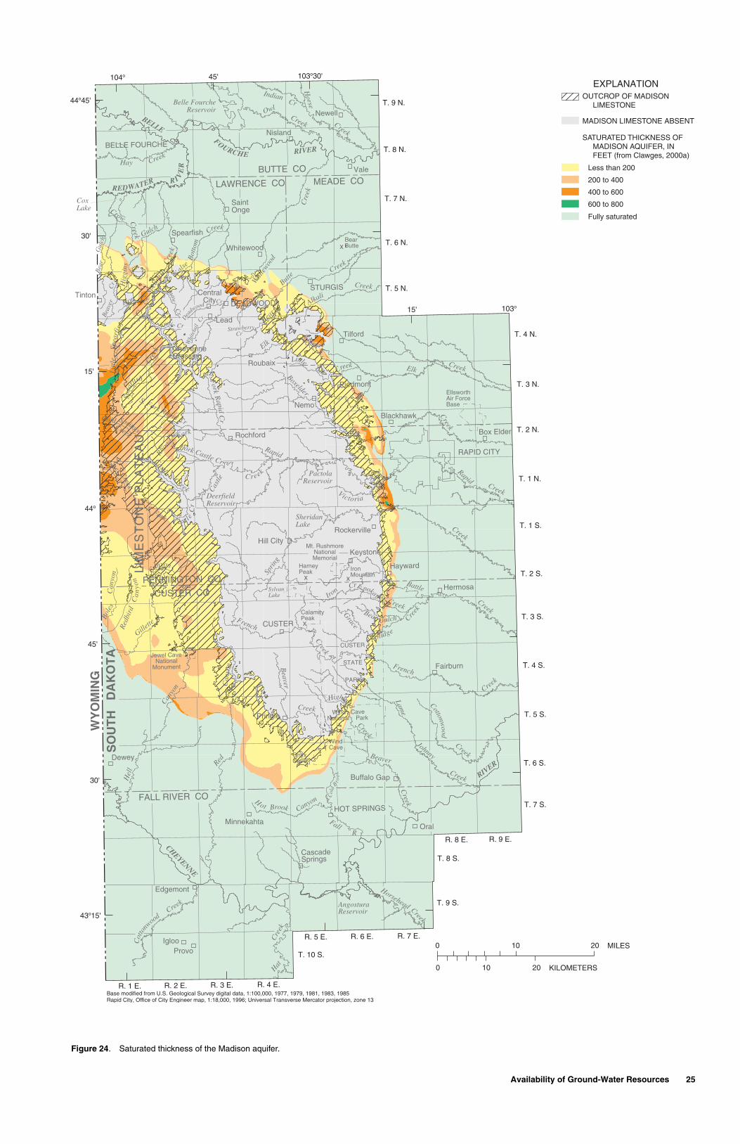
Availability of Ground-Water Resources 25
Figure 24. Saturated thickness of the Madison aquifer.
N. F
orkRapid
Cr
Belle FourcheReservoir
FOURCHE
Victoria
Rhoa
ds Fork
Coolidge
AngosturaReservoir
Castl eC
r
N. Fork Castle Cr
Hel
l
Canyo
n Can
yon
Red
Bea
rG
ulch
Creek
Crow
SheridanLake
Hot Brook Canyon
CoxLake
DeerfieldReservoir
PactolaReservoir
IndianCr
Horse
Creek
OwlCreek
BELLE
RIVER
REDWATER R I VE
R
Cre
ek
Cr
Lit
tle
Spea
rfish
Spea
rfish
Cre
ekSp
earf
ish
Whi
tewoo
d
Cre
ek
Creek
Bear
Butte
Elk
Elk
Creek
Creek
Creek
Boxelder
Rapid
Rapid
Creek
Creek
Sprin
g
Creek
French
Creek
Creek
CreekG
race
Creek
Creek
Cre
ek
S. Fork
Gillette
S. Fork Rapid Cr
Battle
French
Beaver
Beaver
Creek
Creek
Creek
Creek
Creek
Creek
FallR
Hat
Cre
ek
Creek
Horsehead
CHEYENNE
RIVER
Cot
tonw
ood
CreekHay
Bot
tom
Fa
lse
Creek
Spokane
Lame
Johnny
Hig
gins
Bea
ver
Cr
Whi
teta
il
Cr
Cr
Cr
Cr
Gulch
Annie
Squaw
Dea
dwood
Iron
Cr
Cottonwood
Highland
Creek
AlkaliIron Cr
Elk
LittleCreek
Castle
Cas
tleCreek
C reek
Bear Gulch
SylvanLake
Col
d
B
roo
kCr
Strawberry
Bol
esC
anyo
n Canyon
Springs
Beaver Creek
Creek
Red
bird
Cold
Ca
nyo
n
Whitewood
Spearfish
SaintOnge
DEADWOOD
Lead
BELLE FOURCHE
Newell
STURGIS
Blackhawk
Piedmont
Tilford
Box Elder
Hill City
Hermosa
CUSTER
HOT SPRINGS
Edgemont
Minnekahta
Tinton
CheyenneCrossing
CentralCity
Roubaix
Nemo
Vale
Nisland
Hayward
Keystone
Rochford
Pringle
Fairburn
Buffalo Gap
Dewey
CascadeSprings
IglooProvo
Oral
Rockerville
RAPID CITY
LIM
ES
TO
NE
PL
AT
EA
U
Wind CaveNational Park
Jewel CaveNational
Monument
Mt. RushmoreNationalMemorial
CUSTER
STATE
PARK
WindCave
HarneyPeak
x
CalamityPeakx
IronMountainx
OnyxCave
BearButtex
EllsworthAir ForceBase
T. 9 N.
T. 8 N.
T. 7 N.
T. 6 N.
T. 5 N.
T. 4 N.
T. 3 N.
T. 2 N.
T. 1 N.
T. 1 S.
T. 2 S.
T. 3 S.
T. 4 S.
T. 5 S.
T. 6 S.
T. 7 S.
T. 8 S.
T. 9 S.
T. 10 S.
R. 1 E. R. 2 E. R. 3 E. R. 4 E.
R. 5 E. R. 6 E. R. 7 E.
R. 8 E. R. 9 E.
BUTTE CO
LAWRENCE CO MEADE CO
PENNINGTON CO
CUSTER CO
FALL RIVER CO
WY
OM
ING
SO
UT
H
DA
KO
TA
EXPLANATION
MADISON LIMESTONE ABSENT
OUTCROP OF MADISON LIMESTONE
Less than 200
SATURATED THICKNESS OF MADISON AQUIFER, IN FEET (from Clawges, 2000a)
200 to 400
400 to 600
600 to 800
Fully saturated
104o 45' 103o30'
15' 103o
30'
44o45'
15'
44o
45'
30'
43o15'
0 10 20
0 10 20 MILES
KILOMETERS
Base modified from U.S. Geological Survey digital data, 1:100,000, 1977, 1979, 1981, 1983, 1985Rapid City, Office of City Engineer map, 1:18,000, 1996; Universal Transverse Mercator projection, zone 13

26 Ground-Water Resources in the Black Hills Area, South Dakota
Figure 25. Saturated thickness of the Minnelusa aquifer.
N. F
orkRapid
Cr
Belle FourcheReservoir
FOURCHE
Victoria
Rhoa
ds Fork
Coolidge
AngosturaReservoir
Castl eC
r
N. Fork Castle Cr
Hel
l
Canyo
n Can
yon
Red
Bea
rG
ulch
Creek
Crow
SheridanLake
Hot Brook Canyon
CoxLake
DeerfieldReservoir
PactolaReservoir
IndianCr
Horse
Creek
OwlCreek
BELLE
RIVER
REDWATER R I VE
R
Cre
ek
Cr
Lit
tle
Spea
rfish
Spea
rfish
Cre
ekSp
earf
ish
Whi
tewoo
d
Cre
ek
Creek
Bear
Butte
Elk
Elk
Creek
Creek
Creek
Boxelder
Rapid
Rapid
Creek
Creek
Sprin
g
Creek
French
Creek
Creek
CreekG
race
Creek
Creek
Cre
ek
S. Fork
Gillette
S. Fork Rapid Cr
Battle
French
Beaver
Beaver
Creek
Creek
Creek
Creek
Creek
Creek
FallR
Hat
Cre
ek
Creek
Horsehead
CHEYENNE
RIVER
Cot
tonw
ood
CreekHay
Bot
tom
Fa
lse
Creek
Spokane
Lame
Johnny
Hig
gins
Bea
ver
Cr
Whi
teta
il
Cr
Cr
Cr
Cr
Gulch
Annie
Squaw
Dea
dwood
Iron
Cr
Cottonwood
Highland
Creek
AlkaliIron Cr
Elk
LittleCreek
Castle
Cas
tleCreek
C reek
Bear Gulch
SylvanLake
Col
d
B
roo
k
CrStrawberry
Bol
esC
anyo
n Canyon
Springs
Beaver Creek
Creek
Red
bird
Cold
Ca
nyo
n
Whitewood
Spearfish
SaintOnge
DEADWOOD
Lead
BELLE FOURCHE
Newell
STURGIS
Blackhawk
Piedmont
Tilford
Box Elder
Hill City
Hermosa
CUSTER
HOT SPRINGS
Edgemont
Minnekahta
Tinton
CheyenneCrossing
CentralCity
Roubaix
Nemo
Vale
Nisland
Hayward
Keystone
Rochford
Pringle
Fairburn
Buffalo Gap
Dewey
CascadeSprings
Igloo
Provo
Oral
Rockerville
RAPID CITY
LIM
ES
TO
NE
PL
AT
EA
U
Wind CaveNational Park
Jewel CaveNational
Monument
Mt. RushmoreNationalMemorial
CUSTER
STATE
PARK
WindCave
HarneyPeak
x
CalamityPeakx
IronMountainx
OnyxCave
BearButtex
EllsworthAir ForceBase
T. 9 N.
T. 8 N.
T. 7 N.
T. 6 N.
T. 5 N.
T. 4 N.
T. 3 N.
T. 2 N.
T. 1 N.
T. 1 S.
T. 2 S.
T. 3 S.
T. 4 S.
T. 5 S.
T. 6 S.
T. 7 S.
T. 8 S.
T. 9 S.
T. 10 S.
R. 1 E. R. 2 E. R. 3 E. R. 4 E.
R. 5 E. R. 6 E. R. 7 E.
R. 8 E. R. 9 E.
BUTTE CO
LAWRENCE CO MEADE CO
PENNINGTON CO
CUSTER CO
FALL RIVER CO
WY
OM
ING
SO
UT
H
DA
KO
TA
EXPLANATION
MINNELUSA FORMATION ABSENT
OUTCROP OF MINNELUSA FORMATION
Less than 200
SATURATED THICKNESS OF MINNELUSA AQUIFER, IN FEET (from Clawges, 2000b)
200 to 400
400 to 600
600 to 800
800 to 1,000
1,000 to 1,200
Fully saturated
No data
104o 45' 103o30'
15' 103o
30'
44o45'
15'
44o
45'
30'
43o15'
0 10 20
0 10 20 MILES
KILOMETERS
Base modified from U.S. Geological Survey digital data, 1:100,000, 1977, 1979, 1981, 1983, 1985Rapid City, Office of City Engineer map, 1:18,000, 1996; Universal Transverse Mercator projection, zone 13

Water Quality of Ground-Water Resources 27
Figure 26. Selected hydrographs illustrating trends in ground-water levels.
C
3,450
3,600
3,500
3,550
Reptile Gardens Madison (site 4)
1984 1986 1988 1990 1992 1994 1996 1998
1984 1986 1988 1990 1992 1994 1996 1998
B
3,460
3,540
3,480
3,500
3,520
Redwater Minnelusa (site 3)
CALENDAR YEAR
1960 1965 1970 1975 1980 1985 1990 1995 1999
A Whitewood Madison (site 1)Whitewood Minnelusa (site 2)
3,380
3,480
3,400
3,420
3,440
3,460
RAPIDCITY
LIM
ES
TO
NE
PL
AT
EA
U
BUTTE CO
LAWRENCE CO MEADE CO
PENNINGTON CO
CUSTER CO
FALL RIVER CO
WY
OM
ING
SO
UT
H
DA
KO
TA
104o 45' 103o30'
15' 103o
30'
44o45'
15'
44o
45'
30'
43o15'
1, 2
EXPLANATIONOUTCROP OF MADISON LIMESTONE
OUTCROP OF MINNELUSA FORMATION
4
3
WATER QUALITY OF GROUND-WATER RESOURCES
This section of the report includes a summary of water-quality characteristics for both major aquifers and selected minor aqui-fers in the Black Hills area. A summary of water quality relative to water use also is pre-sented. More detailed descriptions of ground-water quality were presented by Williamson and Carter (2001).
Water quality is a measure of the suit-ability of water for a particular use based on selected physical, chemical, and biological characteristics. The quality of ground water is an important consideration because aquifers provide water for a variety of purposes including drinking water, livestock watering, irrigation, and industrial use. The quality of water can change as it flows over the land sur-face in streams and lakes and as it flows underground. Because ground-water and sur-face-water resources in the Black Hills area can be highly interconnected, the quality of surface water can affect the quality of ground water, and vice versa.
Ground water can contain numerous substances (constituents) from natural and human sources that typically are measured using laboratory analyses. Some constituents potentially can cause serious health effects. As ground water comes in contact with soil and rock materials, some of the chemicals, minerals, and nutrients dissolve and become part of the water chemistry. Two fundamental factors influencing water chemistry are the type of geologic materials that are present and the length of time that water is in contact with those materials (Winter and others, 1998), which typically increases constituent concentrations from natural sources.
Chemical constituents in ground water also can result from human sources, such as industrial, domestic, and agricultural chemi-cals, that have the potential to contaminate the water. The potential for ground-water contamination in the Black Hills area can be large because many of the outcrops, which are important aquifer recharge areas, could be subject to various forms of land develop-ment. Rapid ground-water velocities also are possible in many aquifers because of high secondary permeability. Contamination by septic tanks has been documented for some wells in the Blackhawk, Piedmont, and Sturgis areas (Bartlett and West Engineers, Inc., 1998).
Standards and guidelines have been established to protect water for various desig-nated uses. The U.S. Environmental Protec-tion Agency (USEPA) and the States are responsible for establishing the standards for constituents in water that have been shown to pose a risk to human health. Although drinking-water standards apply only to public water supplies, individuals using water from private wells should be aware of potential health risks associated with drinking water that exceeds these standards. Maximum Con-taminant Levels (MCLs) are established for constituents that, if present in drinking water, may cause adverse human health effects; MCLs are enforceable health-based stan-dards (U.S. Environmental Protection Agency, 1994). Secondary Maximum Con-taminant Levels (SMCLs) are established for constituents that can adversely affect the taste, odor, or appearance of water and may result in discontinuation of use of the water; SMCLs are nonenforceable, generally non-
health-based standards that are related to the aesthetics of water use (U.S. Environmental Protection Agency, 1994).
General Characteristics for Major Aquifers
A brief summary of water-quality char-acteristics from Williamson and Carter (2001) for the major aquifers in the study area (Deadwood, Madison, Minnelusa, Minne-kahta, and Inyan Kara aquifers) is presented in this section of the report. Characteristics for the Precambrian aquifer also are included in this section of the report because numerous wells are completed in this aquifer in the crystalline core of the Black Hills.
Water temperature affects the useful-ness of water for many purposes. For example, hot water needs to be cooled prior to consumption; however, hot water is desirable for geothermal heating purposes. The tem-perature of water from wells completed in the Madison aquifer is shown in figure 27. Water temperatures generally increase with well depth. Temperatures measured in the Mad-ison aquifer generally are the warmest of the major aquifers in the study area because it generally is the deepest aquifer used at dis-tance from the outcrop. The Madison aquifer is the primary source of water for warm artesian springs in the southern Black Hills; factors other than aquifer depth may affect water temperatures in this area (Whalen, 1994).
The total of all dissolved mineral con-stituents is measured as the dissolved solids concentration. Specific conductance is a mea-sure of the ability of water to conduct an elec-trical current. It is highly dependent on the amount of dissolved solids (such as salt) in the water. Pure water, such as distilled water, has a very low specific conductance. Specific conductance is an important water-quality measurement because it can be used to esti-mate dissolved solids concentrations, which may affect the taste of water and suitability for various uses. When comparing samples, a higher specific conductance indicates a higher dissolved solids concentration. Dis-solved constituents tend to increase with res-idence time as indicated by the increase in specific conductance in the Madison and Minnelusa aquifers with distance from the Madison Limestone and Minnelusa Forma-tion outcrops (figs. 28 and 29).
Specific conductance generally is lower in water from the Precambrian, Deadwood, and Minnekahta aquifers than in water from the other major aquifers. Generally, water from the Inyan Kara aquifer is high in spe-cific conductance even in some outcrop areas of the Inyan Kara Group (fig. 30) and is higher in specific conductance than the other major aquifers due to greater amounts of shale within the Inyan Kara Group. Water obtained from shales may contain rather high concentrations of dissolved solids (Hem, 1985) and, hence, high specific conductance. Because depths to aquifers increase with dis-tance from outcrop in most locations, concen-trations of dissolved solids generally increase with well depth, as shown by the example relation in figure 31.

28 Ground-Water Resources in the Black Hills Area, South Dakota
Figure 27. Water temperature in the Madison aquifer (modified from Williamson and Carter, 2001).
BUTTE CO
LAWRENCE CO MEADE CO
PENNINGTON CO
CUSTER CO
FALL RIVER CO
WY
OM
ING
SO
UT
H
DA
KO
TA
N. F
orkR
apidC
r
Belle FourcheReservoir
FOURCHE
VictoriaSpring
Rhoa
dsFork
Coolidge
Highland
AngosturaReservoir
Castl eC
r
N. Fork Castle Cr
Hel
l
Canyo
n Can
yon
Red
Bea
rG
ulch
Creek
Crow
SheridanLake
Hot Brook Canyon
CoxLake
DeerfieldReservoir
PactolaReservoir
IndianCr
Horse
Creek
OwlCreek
BELLE
RIVER
REDWATER R I VE
R
Cre
ek
Cr
Lit
tle
Spea
rfis
h
Spea
rfish
Cre
ekSp
earf
ish
Whi
tewoo
d
Cre
ek
Creek
Bear
Butte
Elk
Elk
Creek
Creek
Creek
Boxelder
Rapid
Rapid
Creek
CreekCreek
Spri
ng
Creek
French
Creek
Creek
CreekG
race
Creek
Creek
Cre
ek
S. Fork
Gillette
S. Fork Rapid Cr
Battle
French
Beaver
Beaver
Creek
Creek
Creek
Creek
Cre
ek
Creek
FallR
Hat
Cre
ek
Creek
Horsehead
CHEYENNE
RIVER
Cot
tonw
ood
CreekHay
Bot
tom
False
Creek
Spokane
Lame
Johnny
Hig
gins
Bea
ver
Cr
Whi
teta
il
Cr
Cr
Cr
Cr
Gulch
Annie
Squaw
Dea
dwood
Iron
Cr
Cottonwood
Creek
AlkaliIron Cr
Elk
Little
Creek
Castle
Cas
tleCreek
C reek
Bear Gulch
SylvanLake
Col
d
B
roo
k
CrStrawberry
Bol
esC
anyo
n Canyon
Red
bird
Can
yon
Cold
Beaver
SpringsCreek
Creek
Whitewood
Spearfish
SaintOnge
DEADWOOD
Lead
BELLE FOURCHE
Newell
STURGIS
Blackhawk
Piedmont
Tilford
Box Elder
Hill City
Hermosa
CUSTER
HOT SPRINGS
Edgemont
Minnekahta
Tinton
CheyenneCrossing
CentralCity
Roubaix
Nemo
Vale
Nisland
Hayward
Keystone
Rochford
Pringle
Fairburn
Buffalo Gap
Dewey
CascadeSprings
IglooProvo
Oral
Rockerville
RAPID CITY
LIM
ES
TO
NE
PL
AT
EA
U
Wind CaveNational Park
Jewel CaveNational
Monument
Mt. RushmoreNationalMemorial
CUSTER
STATE
PARK
WindCave
HarneyPeak
x
CalamityPeakx
IronMountainx
OnyxCave
BearButtex
EllsworthAir ForceBase
0 10 20
0 10 20 MILES
KILOMETERS
EXPLANATION
Less than 20
WATER TEMPERATURE, IN DEGREES CELSIUS
20 to 3030 to 4040 to 50Greater than 50
WELL COMPLETED IN MADISON AQUIFER FOR WHICH THERE IS A WATER TEMPERATURE MEASUREMENT
OUTCROP OF MADISON LIMESTONEMADISON LIMESTONE ABSENT
104o 45' 103o30'
15' 103o
30'
44o
45'
15'
44o
45'
30'
43o
15'
Base modified from U.S. Geological Survey digital data,1:100,000, 1977, 1979, 1981, 1983, 1985Rapid City, Office of City Engineer map, 1:18,000, 1996Universal Transverse Mercator projection, zone 13
Figure 28. Specific conductance in the Madison aquifer (modified from Williamson and Carter, 2001).
BUTTE CO
LAWRENCE CO MEADE CO
PENNINGTON CO
CUSTER CO
FALL RIVER CO
WY
OM
ING
SO
UT
H
DA
KO
TA
N. F
orkR
apidC
r
Belle FourcheReservoir
FOURCHE
VictoriaSpring
Rhoa
dsFork
Coolidge
Highland
AngosturaReservoir
Castl eC
r
N. Fork Castle Cr
Hel
l
Canyo
n Can
yon
Red
Bea
rG
ulch
Creek
Crow
SheridanLake
Hot Brook Canyon
CoxLake
DeerfieldReservoir
PactolaReservoir
IndianCr
Horse
Creek
OwlCreek
BELLE
RIVER
REDWATER R I VE
R
Cre
ek
Cr
Lit
tle
Spea
rfis
h
Spea
rfish
Cre
ekSp
earf
ish
Whi
tewoo
d
Cre
ek
Creek
Bear
Butte
Elk
Elk
Creek
Creek
Creek
Boxelder
Rapid
Rapid
Creek
CreekCreek
Spri
ng
Creek
French
Creek
Creek
CreekG
race
Creek
Creek
Cre
ek
S. Fork
Gillette
S. Fork Rapid Cr
Battle
French
Beaver
Beaver
Creek
Creek
Creek
Creek
Cre
ek
Creek
FallR
Hat
Cre
ek
Creek
Horsehead
CHEYENNE
RIVER
Cot
tonw
ood
CreekHay
Bot
tom
False
Creek
Spokane
Lame
Johnny
Hig
gins
Bea
ver
Cr
Whi
teta
il
Cr
Cr
Cr
Cr
Gulch
Annie
Squaw
Dea
dwood
Iron
Cr
Cottonwood
Creek
AlkaliIron Cr
Elk
Little
Creek
Castle
Cas
tleCreek
C reek
Bear Gulch
SylvanLake
Col
d
B
roo
k
CrStrawberry
Bol
esC
anyo
n Canyon
Red
bird
Can
yon
Cold
Beaver
SpringsCreek
Creek
Whitewood
Spearfish
SaintOnge
DEADWOOD
Lead
BELLE FOURCHE
Newell
STURGIS
Blackhawk
Piedmont
Tilford
Box Elder
Hill City
Hermosa
CUSTER
HOT SPRINGS
Edgemont
Minnekahta
Tinton
CheyenneCrossing
CentralCity
Roubaix
Nemo
Vale
Nisland
Hayward
Keystone
Rochford
Pringle
Fairburn
Buffalo Gap
Dewey
CascadeSprings
IglooProvo
Oral
Rockerville
RAPID CITY
LIM
ES
TO
NE
PL
AT
EA
U Wind CaveNational Park
Jewel CaveNational
Monument
Mt. RushmoreNationalMemorial
CUSTER
STATE
PARK
WindCave
HarneyPeak
x
CalamityPeakx
IronMountainx
OnyxCave
BearButtex
EllsworthAir ForceBase
0 10 20
0 10 20 MILES
KILOMETERS
EXPLANATIONOUTCROP OF MADISON LIMESTONEMADISON LIMESTONE ABSENT
Less than 500500 to 1,000
1,000 to 1,500
Greater than 1,500
SPECIFIC CONDUCTANCE OF SAMPLE, IN MICRO- SIEMENS PER CENTI- METER AT 25 DEGREES CELSIUS
104o 45' 103o30'
15' 103o
30'
44o
45'
15'
44o
45'
30'
43o
15'
Base modified from U.S. Geological Survey digital data,1:100,000, 1977, 1979, 1981, 1983, 1985Rapid City, Office of City Engineer map, 1:18,000, 1996Universal Transverse Mercator projection, zone 13
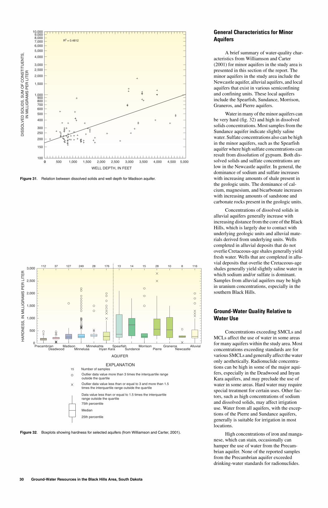
Hardness is related to soap-consuming characteristics of water. Hard water can shorten the life of fabrics and may cause equipment damage. Hardness is determined primarily by the amount of dissolved calcium and magnesium in water. Water that has a hardness less than 61 mg/L (milligrams per liter) is considered soft; 61-120 mg/L, mod-erately hard; 121-180 mg/L, hard; and more than 180 mg/L, very hard (Heath, 1983). Geologic units that contain few carbonate rocks, such as the Precambrian-age rocks, generally contain water with lower hardness than geologic units that contain mostly car-bonate rocks, which are composed primarily of calcium- and magnesium-bearing min-erals. Water in the Madison, Minnelusa, and Minnekahta aquifers generally is hard to very hard (fig. 32) because the formations consist primarily of carbonate rocks. Water in the Deadwood aquifer also is hard to very hard because this unit consists primarily of sand-stone with a calcium carbonate cement.
Water in the Inyan Kara aquifer generally is hard to very hard in or near outcrop areas; however, hardness decreases with increasing distance from the outcrop (fig. 33). Similar to the other major bedrock aquifers, concentra-tions of dissolved solids in the Inyan Kara aquifer increase with increasing distance from the outcrop because calcium and bicar-bonate are replaced by sodium and sulfate as water moves downgradient.
In the Black Hills area, water from the major aquifers generally is fresh and low in dissolved solids in and near outcrop areas except for parts of the Inyan Kara aquifer. The Madison, Minnelusa, and Inyan Kara aquifers may yield slightly saline water (dis-solved solids concentrations between 1,000 and 3,000 mg/L) at distance from the out-crops, especially in the southern Black Hills. The water in these aquifers is highly mineral-ized outside of the study area. In general, con-centrations of sodium, chloride, and sulfate in
the major aquifers increase with distance from the outcrop.
Sulfate affects the taste of water and has an SMCL of 250 mg/L. Sulfate concentra-tions in the Minnelusa aquifer are dependent on the amount of anhydrite present in the Minnelusa Formation. Near the outcrop, sulfate concentrations generally are low (less than 250 mg/L) because anhydrite has been removed by dissolution. An abrupt increase in sulfate concentrations occurs downgra-dient, where a transition zone occurs around the core of the Black Hills. This transition zone is an area within which the sulfate con-centrations range from 250 to 1,000 mg/L (fig. 34) and marks an area of active removal of anhydrite by dissolution. Downgradient from the transition zone, sulfate concentra-tions are greater than 1,000 mg/L, which delineates a zone in which thick anhydrite beds remain in the formation. The transition zone probably is moving downgradient over geologic time as the anhydrite in the forma-tion is dissolved (Kyllonen and Peter, 1987).

Water Quality of Ground-Water Resources 29
Figure 29. Specific conductance in the Minnelusa aquifer (modified from Williamson and Carter, 2001).
BUTTE CO
LAWRENCE CO MEADE CO
PENNINGTON CO
CUSTER CO
FALL RIVER CO
WY
OM
ING
SO
UT
H
DA
KO
TA
N. F
orkR
apidC
r
Belle FourcheReservoir
FOURCHE
VictoriaSpring
Rhoa
dsFork
Coolidge
Highland
AngosturaReservoir
Castl eC
r
N. Fork Castle Cr
Hel
l
Canyo
n Can
yon
Red
Bea
rG
ulch
Creek
Crow
SheridanLake
Hot Brook Canyon
CoxLake
DeerfieldReservoir
PactolaReservoir
IndianCr
Horse
Creek
OwlCreek
BELLE
RIVER
REDWATER R I VE
R
Cre
ek
Cr
Lit
tle
Spea
rfis
h
Spea
rfish
Cre
ekSp
earf
ish
Whi
tewoo
d
Cre
ekCreek
Bear
Butte
Elk
Elk
Creek
Creek
Creek
Boxelder
Rapid
Rapid
Creek
Creek
Creek
Spri
ng
Creek
French
Creek
Creek
CreekG
race
Creek
Creek
Cre
ek
S. Fork
Gillette
S. Fork Rapid Cr
Battle
French
Beaver
Beaver
Creek
Creek
Creek
Creek
Cre
ek
Creek
Fall R
Hat
Cre
ek
Creek
Horsehead
CHEYENNE
RIVER
Cot
tonw
ood
CreekHay
Bot
tom
False
Creek
Spokane
Lame
Johnny
Hig
gins
Bea
ver
Cr
Whi
teta
il
Cr
Cr
Cr
Cr
Gulch
Annie
Squaw
Dea
dwood
Iron
Cr
Cottonwood
Creek
AlkaliIron Cr
Elk
Little
Creek
Castle
Cas
tleCreek
C reek
Bear Gulch
SylvanLake
Col
d
B
roo
k
CrStrawberry
Bol
esC
anyo
n Canyon
Red
bird
Can
yon
Cold
Beaver
SpringsCreek
Creek
Whitewood
Spearfish
SaintOnge
DEADWOOD
Lead
BELLE FOURCHE
Newell
STURGIS
Blackhawk
Piedmont
Tilford
Box Elder
Hill City
Hermosa
CUSTER
HOT SPRINGS
Edgemont
Minnekahta
Tinton
CheyenneCrossing
CentralCity
Roubaix
Nemo
Vale
Nisland
Hayward
Keystone
Rochford
Pringle
Fairburn
Buffalo Gap
Dewey
CascadeSprings
IglooProvo
Oral
Rockerville
RAPID CITY
LIM
ES
TO
NE
PL
AT
EA
U
Wind CaveNational Park
Jewel CaveNational
Monument
Mt. RushmoreNationalMemorial
CUSTER
STATE
PARK
WindCave
HarneyPeak
x
CalamityPeakx
IronMountainx
OnyxCave
BearButtex
EllsworthAir ForceBase
0 10 20
0 10 20 MILES
KILOMETERS
EXPLANATIONOUTCROP OF MINNELUSA FORMATIONMINNELUSA FORMATION ABSENT
104o 45' 103o30'
15' 103o
30'
44o
45'
15'
44o
45'
30'
43o
15'
SPECIFIC CONDUCTANCE OF SAMPLE, IN MICRO- SIEMENS PER CENTI- METER AT 25 DEGREES CELSIUS
Less than 500500 to 1,0001,000 to 1,500
Greater than 1,500
Base modified from U.S. Geological Survey digital data,1:100,000, 1977, 1979, 1981, 1983, 1985Rapid City, Office of City Engineer map, 1:18,000, 1996Universal Transverse Mercator projection, zone 13
Figure 30. Specific conductance in the Inyan Kara aquifer (modified from Williamson and Carter, 2001).
BUTTE CO
LAWRENCE CO MEADE CO
PENNINGTON CO
CUSTER CO
FALL RIVER CO
WY
OM
ING
SO
UT
H
DA
KO
TA
N. F
orkR
apidC
r
Belle FourcheReservoir
FOURCHE
VictoriaSpring
Rhoa
dsFork
Coolidge
Highland
AngosturaReservoir
Castl eC
r
N. Fork Castle Cr
Hel
l
Canyo
n Can
yon
Red
Bea
rG
ulch
Creek
Crow
SheridanLake
Hot Brook Canyon
CoxLake
DeerfieldReservoir
PactolaReservoir
IndianCr
Horse
Creek
OwlCreek
BELLE
RIVER
REDWATER R I VE
R
Cre
ek
Cr
Lit
tle
Spea
rfis
h
Spea
rfish
Cre
ekSp
earf
ish
Whi
tewoo
d
Cre
ek
Creek
Bear
Butte
Elk
Elk
Creek
Creek
Creek
Boxelder
Rapid
Rapid
Creek
CreekCreek
Spri
ng
Creek
French
Creek
Creek
CreekG
race
Creek
Creek
Cre
ek
S. Fork
Gillette
S. Fork Rapid Cr
Battle
French
Beaver
Beaver
Creek
Creek
Creek
Creek
Cre
ek
Creek
FallR
Hat
Cre
ek
Creek
Horsehead
CHEYENNE
RIVER
Cot
tonw
ood
CreekHay
Bot
tom
False
Creek
Spokane
Lame
Johnny
Hig
gins
Bea
ver
Cr
Whi
teta
il
Cr
Cr
Cr
Cr
Gulch
Annie
Squaw
Dea
dwood
Iron
Cr
Cottonwood
Creek
AlkaliIron Cr
Elk
Little
Creek
Castle
Cas
tleCreek
C reek
Bear Gulch
SylvanLake
Col
d
B
roo
k
CrStrawberry
Bol
esC
anyo
n Canyon
Red
bird
Can
yon
Cold
Beaver
SpringsCreekCreek
Whitewood
Spearfish
SaintOnge
DEADWOOD
Lead
BELLE FOURCHE
Newell
STURGIS
Blackhawk
Piedmont
Tilford
Box Elder
Hill City
Hermosa
CUSTER
HOTSPRINGS
Edgemont
Minnekahta
Tinton
CheyenneCrossing
CentralCity
Roubaix
Nemo
Vale
Nisland
Hayward
Keystone
Rochford
Pringle
Fairburn
Buffalo Gap
Dewey
CascadeSprings
Igloo
Provo
Oral
Rockerville
RAPID CITY
LIM
ES
TO
NE
PL
AT
EA
U Wind CaveNational Park
Jewel CaveNational
Monument
Mt. RushmoreNationalMemorial
CUSTER
STATE
PARK
WindCave
HarneyPeak
x
CalamityPeakx
IronMountainx
OnyxCave
BearButtex
EllsworthAir ForceBase
0 10 20
0 10 20 MILES
KILOMETERS
EXPLANATIONOUTCROP OF INYAN KARA GROUPINYAN KARA GROUP ABSENT
104o 45' 103o30'
15' 103o
30'
44o
45'
15'
44o
45'
30'
43o
15'
SPECIFIC CONDUCTANCE OF SAMPLE, IN MICRO- SIEMENS PER CENTI- METER AT 25 DEGREES CELCIUS
Less than 500500 to 1,0001,000 to 1,500
Greater than 1,500
Base modified from U.S. Geological Survey digital data,1:100,000, 1977, 1979, 1981, 1983, 1985Rapid City, Office of City Engineer map, 1:18,000, 1996Universal Transverse Mercator projection, zone 13
Radionuclides are unstable isotopes that exist throughout the environment and have a certain probability of decay. Because several radionuclides are known to cause various types of cancer, drinking-water stan-dards exist for these radionuclides. Most nat-urally occurring radionuclides in water are the result of radioactive decay of uranium and thorium. Radioactivity is the release of energy and energetic particles by changes occurring within atomic or nuclear structures (Hem, 1985). Alpha, beta, and gamma radia-tion are types of radiation that commonly are measured in ground water. Radionuclide analyses can be expressed in terms of disinte-grations per unit time (typically in units of picocuries per liter) or in mass units (typi-cally in units of micrograms per liter). Some of the radionuclide names include numbers, such as radium-226 and radium-228; these numbers represent chemical variations of the element.
Radium locates primarily in bone in humans; however, inhalation or ingestion of radium may result in lung cancer. Inhaled radon is known to cause lung cancer, and ingested radon is believed to cause cancer. In the Deadwood aquifer, more than 30 percent of the samples analyzed for radium-226 or radium-226 and radium-228 exceeded the MCL of 5 pCi/L (picocuries per liter) for the combined radium-226 and radium-228 stan-dard. Almost 90 percent of the samples from the Deadwood aquifer exceed the proposed MCL of 300 pCi/L for radon in States without an active indoor air program (U.S. Environmental Protection Agency, 1999); three of these samples also exceed the pro-posed MCL of 4,000 pCi/L for radon in States with an active indoor air program (U.S. Environmental Protection Agency, 1999) (fig. 35).
Uranium is a chemical and radiological hazard and carcinogen. Uranium deposits have been discovered and mined in the Inyan
Kara Group in the southern Black Hills. Ura-nium may be introduced into the Inyan Kara Group by the artesian recharge of water from the Minnelusa aquifer (Gott, 1974). Some water in the Inyan Kara aquifer, especially in the southern Black Hills, contains relatively high concentrations of radionuclides. Almost 20 percent of the samples collected from the Inyan Kara aquifer exceed the MCL for the combined radium-226 and radium-228 stan-dard; all but one of the samples exceeding this standard were from wells in the southern Black Hills. About 4 percent of the samples from the Inyan Kara aquifer exceed the MCL of 30 µg/L (micrograms per liter) for ura-nium; all the samples exceeding the uranium MCL were from wells located in the southern Black Hills. In general, gross alpha-particle activity, gross-beta activity, and radium-226 are higher in the Deadwood and Inyan Kara aquifers than in the Madison, Minnelusa, and Minnekahta aquifers.
30 Ground-Water Resources in the Black Hills Area, South Dakota
Figure 31. Relation between dissolved solids and well depth for Madison aquifer.
WELL DEPTH, IN FEET
0 5,0000 500 1,000 1,500 2,000 2,500 3,000 3,500 4,000 4,500100
10,000
150
200
250
300
400
500
600700800900
1,000
1,500
2,000
2,500
3,000
4,000
5,000
6,0007,0008,0009,000
DIS
SO
LVE
D S
OLI
DS
, SU
M O
F C
ON
ST
ITU
EN
TS
,IN
MIL
LIG
RA
MS
PE
R L
ITE
R
R2 = 0.4812
General Characteristics for Minor Aquifers
A brief summary of water-quality char-acteristics from Williamson and Carter (2001) for minor aquifers in the study area is presented in this section of the report. The minor aquifers in the study area include the Newcastle aquifer, alluvial aquifers, and local aquifers that exist in various semiconfining and confining units. These local aquifers include the Spearfish, Sundance, Morrison, Graneros, and Pierre aquifers.
Water in many of the minor aquifers can be very hard (fig. 32) and high in dissolved solids concentrations. Most samples from the Sundance aquifer indicate slightly saline water. Sulfate concentrations also can be high in the minor aquifers, such as the Spearfish aquifer where high sulfate concentrations can result from dissolution of gypsum. Both dis-solved solids and sulfate concentrations are low in the Newcastle aquifer. In general, the dominance of sodium and sulfate increases with increasing amounts of shale present in the geologic units. The dominance of cal-cium, magnesium, and bicarbonate increases with increasing amounts of sandstone and carbonate rocks present in the geologic units.
Concentrations of dissolved solids in alluvial aquifers generally increase with increasing distance from the core of the Black Hills, which is largely due to contact with underlying geologic units and alluvial mate-rials derived from underlying units. Wells completed in alluvial deposits that do not overlie Cretaceous-age shales generally yield fresh water. Wells that are completed in allu-vial deposits that overlie the Cretaceous-age shales generally yield slightly saline water in which sodium and/or sulfate is dominant. Samples from alluvial aquifers may be high in uranium concentrations, especially in the southern Black Hills.
Ground-Water Quality Relative to Water Use
Concentrations exceeding SMCLs and MCLs affect the use of water in some areas for many aquifers within the study area. Most concentrations exceeding standards are for various SMCLs and generally affect the water only aesthetically. Radionuclide concentra-tions can be high in some of the major aqui-fers, especially in the Deadwood and Inyan Kara aquifers, and may preclude the use of water in some areas. Hard water may require special treatment for certain uses. Other fac-tors, such as high concentrations of sodium and dissolved solids, may affect irrigation use. Water from all aquifers, with the excep-tions of the Pierre and Sundance aquifers, generally is suitable for irrigation in most locations.
High concentrations of iron and manga-nese, which can stain, occasionally can hamper the use of water from the Precam-brian aquifer. None of the reported samples from the Precambrian aquifer exceeded drinking-water standards for radionuclides.
Figure 32. Boxplots showing hardness for selected aquifers (from Williamson and Carter, 2001).
25th percentile
Median
75th percentile
Data value less than or equal to 1.5 times the interquartilerange outside the quartile
Outlier data value less than or equal to 3 and more than 1.5times the interquartile range outside the quartile
Outlier data value more than 3 times the interquartile rangeoutside the quartile
EXPLANATIONNumber of samples15
AQUIFER
PrecambrianDeadwood
MadisonMinnelusa
MinnekahtaInyan Kara
SpearfishSundance
MorrisonPierre
Graneros AlluvialNewcastle
0
3,000
500
1,000
1,500
2,000
2,500
HA
RD
NE
SS
, IN
MIL
LIG
RA
MS
PE
R L
ITE
R
112 37 127 249 28 176 13 14 15 28 10 8 116

Water Quality of Ground-Water Resources 31
Figure 33. Hardness in the Inyan Kara aquifer (modified from Williamson and Carter, 2001).
BUTTE CO
LAWRENCE CO MEADE CO
PENNINGTON CO
CUSTER CO
FALL RIVER CO
WY
OM
ING
SO
UT
H
DA
KO
TA
N. F
orkR
apidC
r
Belle FourcheReservoir
FOURCHE
VictoriaSpring
Rhoa
dsFork
Coolidge
Highland
AngosturaReservoir
Castl eC
r
N. Fork Castle Cr
Hel
l
Canyo
n Can
yon
Red
Bea
rG
ulch
Creek
Crow
SheridanLake
Hot Brook Canyon
CoxLake
DeerfieldReservoir
PactolaReservoir
IndianCr
Horse
Creek
OwlCreek
BELLE
RIVER
REDWATER R I VE
R
Cre
ek
Cr
Lit
tle
Spea
rfis
h
Spea
rfish
Cre
ekSp
earf
ish
Whi
tewoo
d
Cre
ekCreek
Bear
Butte
Elk
Elk
Creek
Creek
Creek
Boxelder
Rapid
Rapid
Creek
CreekCreek
Spri
ng
Creek
French
Creek
Creek
CreekG
race
Creek
Creek
Cre
ek
S. Fork
Gillette
S. Fork Rapid Cr
Battle
French
Beaver
Beaver
Creek
Creek
Creek
Creek
Cre
ek
Creek
FallR
Hat
Cre
ek
Creek
Horsehead
CHEYENNE
RIVER
Cot
tonw
ood
CreekHay
Bot
tom
False
Creek
Spokane
Lame
Johnny
Hig
gins
Bea
ver
Cr
Whi
teta
il
Cr
Cr
Cr
Cr
Gulch
Annie
Squaw
Dea
dwood
Iron
Cr
Cottonwood
Creek
AlkaliIron Cr
Elk
Little
Creek
Castle
Cas
tleCreek
C reek
Bear Gulch
SylvanLake
Col
d
B
roo
k
CrStrawberry
Bol
esC
anyo
n Canyon
Red
bird
Can
yon
Cold
Beaver
SpringsCreek
Creek
Whitewood
Spearfish
SaintOnge
DEADWOOD
Lead
BELLE FOURCHE
Newell
STURGIS
Blackhawk
Piedmont
Tilford
Box Elder
Hill City
Hermosa
CUSTER
HOT SPRINGS
Edgemont
Minnekahta
Tinton
CheyenneCrossing
CentralCity
Roubaix
Nemo
Vale
Nisland
Hayward
Keystone
Rochford
Pringle
Fairburn
Buffalo Gap
Dewey
CascadeSprings
IglooProvo
Oral
Rockerville
RAPID CITY
LIM
ES
TO
NE
PL
AT
EA
U
Wind CaveNational Park
Jewel CaveNational
Monument
Mt. RushmoreNationalMemorial
CUSTER
STATE
PARK
WindCave
HarneyPeak
x
CalamityPeakx
IronMountainx
OnyxCave
BearButtex
EllsworthAir ForceBase
0 10 20
0 10 20 MILES
KILOMETERS
EXPLANATION
Very hard, greater than 180
WATER HARDNESS, IN MILLI- GRAMS PER LITER
Hard, 121 to 180Moderately hard, 61 to 121Soft, less than 61
WELL COMPLETED IN INYAN KARA AQUIFER FOR WHICH THERE IS A HARD- NESS ANALYSIS
OUTCROP OF INYAN KARA GROUP
INYAN KARA GROUP ABSENT
104o 45' 103o30'
15' 103o
30'
44o
45'
15'
44o
45'
30'
43o
15'
Base modified from U.S. Geological Survey digital data,1:100,000, 1977, 1979, 1981, 1983, 1985Rapid City, Office of City Engineer map, 1:18,000, 1996Universal Transverse Mercator projection, zone 13
Figure 34. Sulfate concentrations in the Minnelusa aquifer (modified from Naus and others, 2001).
BUTTE CO
LAWRENCE CO MEADE CO
PENNINGTON CO
CUSTER CO
FALL RIVER CO
WY
OM
ING
SO
UT
H
DA
KO
TA
N. F
orkR
apidC
r
Belle FourcheReservoir
FOURCHE
VictoriaSpring
Rhoa
dsFork
Coolidge
Highland
AngosturaReservoir
Castl eC
r
N. Fork Castle Cr
Hel
l
Canyo
n Can
yon
Red
Bea
rG
ulch
Creek
Crow
SheridanLake
Hot Brook Canyon
CoxLake
DeerfieldReservoir
PactolaReservoir
IndianCr
Horse
Creek
OwlCreek
BELLE
RIVER
REDWATER R I VE
R
Cre
ek
Cr
Lit
tle
Spea
rfis
h
Spea
rfish
Cre
ekSp
earf
ish
Whi
tewoo
d
Cre
ek
Creek
Bear
Butte
Elk
Elk
Creek
Creek
Creek
Boxelder
Rapid
Rapid
Creek
CreekCreek
Spri
ng
Creek
French
Creek
Creek
CreekG
race
Creek
Creek
Cre
ek
S. Fork
Gillette
S. Fork Rapid Cr
Battle
French
Beaver
Beaver
Creek
Creek
Creek
Creek
Cre
ek
Creek
FallR
Hat
Cre
ek
Creek
Horsehead
CHEYENNE
RIVER
Cot
tonw
ood
CreekHay
Bot
tom
False
Creek
Spokane
Lame
Johnny
Hig
gins
Bea
ver
Cr
Whi
teta
il
Cr
Cr
Cr
Cr
Gulch
Annie
Squaw
Dea
dwood
Iron
Cr
Cottonwood
Creek
AlkaliIron Cr
Elk
Little
Creek
Castle
Cas
tleCreek
C reek
Bear Gulch
SylvanLake
Col
d
B
roo
k
CrStrawberry
Bol
esC
anyo
n Canyon
Red
bird
Can
yon
Cold
Beaver
SpringsCreek
Creek
Whitewood
Spearfish
SaintOnge
DEADWOOD
Lead
BELLE FOURCHE
Newell
STURGIS
Blackhawk
Piedmont
Tilford
Box Elder
Hill City
Hermosa
CUSTER
HOT SPRINGS
Edgemont
Minnekahta
Tinton
CheyenneCrossing
CentralCity
Roubaix
Nemo
Vale
Nisland
Hayward
Keystone
Rochford
Pringle
Fairburn
Buffalo Gap
Dewey
CascadeSprings
IglooProvo
Oral
Rockerville
RAPID CITY
LIM
ES
TO
NE
PL
AT
EA
U Wind CaveNational Park
Jewel CaveNational
Monument
Mt. RushmoreNationalMemorial
CUSTER
STATE
PARK
WindCave
HarneyPeak
x
CalamityPeakx
IronMountainx
OnyxCave
BearButtex
EllsworthAir ForceBase
0 10 20
0 10 20 MILES
KILOMETERS
Less than 250
SULFATE CONCENTRATION, IN MILLIGRAMS PER LITER
250 to 1,000Greater than 1,000
WELL COMPLETED IN MINNELUSA AQUIFER FOR WHICH THERE IS A SULFATE ANALYSIS
EXPLANATIONOUTCROP OF MINNELUSA FORMATIONMINNELUSA FORMATION ABSENT
104o 45' 103o30'
15' 103o
30'
44o
45'
15'
44o
45'
30'
43o
15'
Base modified from U.S. Geological Survey digital data,1:100,000, 1977, 1979, 1981, 1983, 1985Rapid City, Office of City Engineer map, 1:18,000, 1996Universal Transverse Mercator projection, zone 13
The principal deterrents to use of water from the Deadwood aquifer are high concen-trations of radionuclides, including radium-226 and radon. In addition, concentrations of iron and manganese can be high.
Water from the Madison aquifer can contain high concentrations of iron and man-ganese that may hamper its use. Water from the Madison aquifer is hard to very hard and may require special treatment for certain uses. In downgradient wells (generally deeper than 2,000 feet), concentrations of dissolved solids and sulfate also may deter use from this aquifer. Hot water, from deep wells and in the Hot Springs area, may not be desirable for some uses. Radionuclide con-centrations in the Madison aquifer generally are acceptable.
In water from the Minnelusa aquifer, hardness and high concentrations of iron and manganese may hamper use. Generally, downgradient wells (generally deeper than 1,000 feet) also have high concentrations of
dissolved solids and sulfate. Hot water from deep wells may not be desirable for some uses. Arsenic concentrations in the Min-nelusa aquifer exceed the MCL of 10 µg/L in some locations. Only a few samples exceed the MCLs for various radionuclides.
The use of water from the Inyan Kara aquifer may be hampered by high concentra-tions of dissolved solids, iron, sulfate, and manganese. In the southern Black Hills, radium-226 and uranium concentrations in water from this aquifer also may preclude its use. Hard water from wells located on or near the outcrop of the Inyan Kara Group may require special treatment. Suitability for irri-gation may be affected by high dissolved solids and sodium concentrations.
The use of water from the minor aqui-fers may be hampered by hardness and con-centrations of dissolved solids and sulfate. Concentrations of radionuclides, with the exception of uranium, generally are at accept-able levels in samples from these minor
aquifers. Concentrations of selenium, which may be harmful or potentially toxic if ingested in moderate excess for a long time (Callahan and others, 1979), are an additional deterrent to use of water from the Sundance aquifer in some places. Water from the Pierre and Sundance aquifers generally is not suit-able for irrigation because dissolved solids concentrations generally are high. Water from the other minor aquifers generally is suitable for irrigation, but may not be in spe-cific locations if concentrations of either dissolved solids or sodium are high.
Water from alluvial aquifers generally is very hard and may require special treat-ment for certain uses. High concentrations of dissolved solids, sulfate, iron, and manganese may limit the use of water from alluvial aqui-fers that overlie the Cretaceous-age shales. In the southern Black Hills, uranium concentra-tions in alluvial aquifers can be high in many locations.

32 Ground-Water Resources in the Black Hills Area, South Dakota
Figure 35. Radon concentrations in the Deadwood aquifer (modified from Williamson and Carter, 2001).
BUTTE CO
LAWRENCE CO MEADE CO
PENNINGTON CO
CUSTER CO
FALL RIVER CO
WY
OM
ING
SO
UT
H
DA
KO
TA
N. F
orkR
apidC
r
Belle FourcheReservoir
FOURCHE
VictoriaSpring
Rhoa
dsFork
Coolidge
Highland
AngosturaReservoir
Castl eC
r
N. Fork Castle Cr
Hel
l
Canyo
n Can
yon
Red
Bea
rG
ulch
Creek
Crow
SheridanLake
Hot Brook Canyon
CoxLake
DeerfieldReservoir
PactolaReservoir
IndianCr
Horse
Creek
OwlCreek
BELLE
RIVER
REDWATER R I VE
R
Cre
ek
Cr
Lit
tle
Spea
rfis
h
Spea
rfish
Cre
ekSp
earf
ish
Whi
tewoo
d
Cre
ekCreek
Bear
Butte
Elk
Elk
Creek
Creek
Creek
Boxelder
Rapid
Rapid
Creek
CreekCreek
Spri
ng
Creek
French
Creek
Creek
CreekG
race
Creek
Creek
Cre
ek
S. Fork
Gillette
S. Fork Rapid Cr
Battle
French
Beaver
Beaver
Creek
Creek
Creek
Creek
Cre
ek
Creek
FallR
Hat
Cre
ek
Creek
Horsehead
CHEYENNE
RIVER
Cot
tonw
ood
CreekHay
Bot
tom
False
Creek
Spokane
Lame
Johnny
Hig
gins
Bea
ver
Cr
Whi
teta
il
Cr
Cr
Cr
Cr
Gulch
Annie
Squaw
Dea
dwood
Iron
Cr
Cottonwood
Creek
AlkaliIron Cr
Elk
Little
Creek
Castle
Cas
tleCreek
C reek
Bear Gulch
SylvanLake
Col
dB
roo
k
CrStrawberry
Bol
esC
anyo
n Canyon
Red
bird
Can
yon
Cold
Beaver
SpringsCreek
Creek
Whitewood
Spearfish
SaintOnge
DEADWOOD
Lead
BELLE FOURCHE
Newell
STURGIS
Blackhawk
Piedmont
Tilford
Box Elder
Hill City
Hermosa
CUSTER
HOT SPRINGS
Edgemont
Minnekahta
Tinton
CheyenneCrossing
CentralCity
Roubaix
Nemo
Vale
Nisland
Hayward
Keystone
Rochford
Pringle
Fairburn
Buffalo Gap
Dewey
CascadeSprings
IglooProvo
Oral
Rockerville
RAPID CITY
LIM
ES
TO
NE
PL
AT
EA
U
Wind CaveNational Park
Jewel CaveNational
Monument
Mt. RushmoreNationalMemorial
CUSTER
STATE
PARK
WindCave
HarneyPeak
x
CalamityPeakx
IronMountainx
OnyxCave
BearButtex
EllsworthAir ForceBase
5,8005,800
6,6006,600
5,3005,300
2,7002,700
1,4001,400
1,5001,500
900900
560560
800800920920
1,6001,600
220220
8080
1,3001,300690690
5,800
6,600
5,300
2,700
1,400 1,100
1,500
900
560
800920
1,600
220
80
1,300690
0 10 20
0 10 20 MILES
KILOMETERS
OUTCROP OF DEADWOOD FORMATION
DEADWOOD FORMATION ABSENT
RADON CONCENTRATION OF SAMPLE—Number is radon concentration in picocuries per liter
Less than 300
300 to 3,000
Greater than 3,000
EXPLANATION
80
500
5,300
104o 45' 103o30'
15' 103o
30'
44o45'
15'
44o
45'
30'
43o15'
Base modified from U.S. Geological Survey digital data,1:100,000, 1977, 1979, 1981, 1983, 1985Rapid City, Office of City Engineer map, 1:18,000, 1996Universal Transverse Mercator projection, zone 13
SUMMARY
The availability of ground-water resources in the Black Hills area is influenced by many factors including location, local recharge and ground-water flow conditions, and structural features. Thus, the availability of water is variable throughout the Black Hills area, and even when water is available, it may not be suitable for various uses depending on the water quality.
The major bedrock aquifers in the Black Hills area are the Deadwood, Madison, Minnelusa, Minnekahta, and Inyan Kara aquifers. Minor bedrock aquifers occur in other hydrogeologic units, including con-fining units, due to fracturing and inter-bedded permeable layers.
The Precambrian-age basement rocks generally have low permeability and form the
lower confining unit for a series of sedimen-tary aquifers. However, localized aquifers occur in the igneous and metamorphic rocks that make up the central crystalline core of the Black Hills and are referred to collec-tively as the Precambrian aquifer. Water-table (unconfined) conditions generally occur in the Precambrian aquifer, and topography can strongly control ground-water flow direc-tions. The aquifer is considered to be con-tained in the area where the Precambrian-age rocks are exposed in the central core of the Black Hills.
Surrounding the central crystalline core is a layered series of sedimentary rocks including limestones, sandstones, and shales that are exposed in roughly concentric rings around the uplifted flanks of the Black Hills. The more permeable of these sedimentary rocks—the Deadwood Formation, Madison
Limestone, Minnelusa Formation, Minne-kahta Limestone, and Inyan Kara Group—contain major aquifers that are able to store and transmit large quantities of water and are used extensively as water supplies within and beyond the study area. Alluvial deposits along streams also commonly are used as local aquifers.
Various information and maps are pre-sented in this report to help characterize water availability and quality in locations throughout the Black Hills. However, there is no guarantee of obtaining usable water at any location due to the extreme potential vari-ability in conditions that can affect the avail-ability and quality of ground water in the area. Maps presented in this report include the distribution of hydrogeologic units; depth to the top of the five formations that contain major aquifers; thickness of the five forma-tions that contain major aquifers; potentio-metric maps for the five major aquifers; saturated thickness of the Madison and Minnelusa aquifers; water temperature in the Madison aquifer; specific conductance in the Madison, Minnelusa, and Inyan Kara aqui-fers; hardness in the Inyan Kara aquifer; sul-fate concentrations in the Minnelusa aquifer; and radon concentrations in the Deadwood aquifer.
The total volume of recoverable water stored in the major aquifers (including the Precambrian aquifer) within the study area is estimated as 256 million acre-feet. Although the volume of stored water is very large, water quality may not be suitable for all uses in some parts of the study area.
Water-level records are presented for selected observation wells to illustrate poten-tial fluctuations in water levels that can occur in the bedrock aquifers. In general, there is very little indication of long-term water-level declines from ground-water withdrawals in any of the bedrock aquifers in the Black Hills area. However, dry wells or reduced pumping capacity could result during periods of declining water levels.
Most limitations for the use of ground water are related to aesthetic qualities associ-ated with hardness and high concentrations of chloride, sulfate, sodium, manganese, and iron. Water from the major bedrock aquifers generally is fresh and low in dissolved solids concentrations in and near outcrop areas but becomes progressively more saline with dis-tance from the outcrops. In the Minnelusa aquifer, concentrations of dissolved sulfate vary markedly over short distances, influ-enced by a zone of active anhydrite dissolu-tion. Water from most minor aquifers generally has higher concentrations of dis-solved sulfate than major aquifers because of larger influence from shale layers.
Water from all aquifers, with the excep-tions of the Pierre and Sundance aquifers, generally is suitable for irrigation in most locations. Very few health-related limitations exist for ground water; most of these limita-tions are for radionuclides, such as radon and uranium, especially in the Deadwood and Inyan Kara aquifers. In addition, high con-centrations of arsenic have been detected in a few samples from the Minnelusa aquifer.

References 33
REFERENCES
Bartlett and West Engineers, Inc., 1998, Piedmont Valley water quality assessment study—Final report: Bismarck, N. Dak., Bartlett and West Engineers, Inc. [variously paged].
Callahan, M.A., Slimak, M.W., Gabel, N.W., May, I.P., Fowler, C.F., Freed, J.R., Jennings, Patricia, Durfee, R.L., Whitmore, F.C., Maestri, Bruno, Mabey, W.R., Holt, B.R., and Gould, Constance, 1979, Water-related environmental fate of 129 priority pollutants, Volume I—Introduction and technical back-ground, metals and inorganics, pesticides and PCBs: U.S. Environmental Protection Agency, Office of Water Planning and Stan-dards, Office of Water and Waste Manage-ment, EPA-440/4-79-029a [variously paged].
Carter, J.M., Driscoll, D.G., Williamson, J.E., and Lindquist, V.A., 2002, Atlas of water resources in the Black Hills area, South Dakota: U.S. Geological Survey Hydrologic Investigations Atlas HA-747, 120 p.
Carter, J.M., and Redden, J.A., 1999a, Altitude of the top of the Inyan Kara Group in the Black Hills area, South Dakota: U.S. Geological Survey Hydrologic Investigations Atlas HA-744-A, 2 sheets, scale 1:100,000.
———1999b, Altitude of the top of the Minne-kahta Limestone in the Black Hills area, South Dakota: U.S. Geological Survey Hydrologic Investigations Atlas HA-744-B, 2 sheets, scale 1:100,000.
———1999c, Altitude of the top of the Min-nelusa Formation in the Black Hills area, South Dakota: U.S. Geological Survey Hydrologic Investigations Atlas HA-744-C, 2 sheets, scale 1:100,000.
———1999d, Altitude of the top of the Madison Limestone in the Black Hills area, South Dakota: U.S. Geological Survey Hydrologic Investigations Atlas HA-744-D, 2 sheets, scale 1:100,000.
———1999e, Altitude of the top of the Dead-wood Formation in the Black Hills area, South Dakota: U.S. Geological Survey Hydrologic Investigations Atlas HA-744-E, 2 sheets, scale 1:100,000.
Clark, D.W., and Briar, D.W., 1993, What is ground water?: U.S. Geological Survey Open-File Report 93-643, 2 p.
Clawges, R.M., 2000a, Digital map of saturated thickness of the Madison aquifer, Black Hills, South Dakota: U.S. Geological Survey data available on the World Wide Web, accessed July 2, 2001, at URL http://water.usgs.gov/lookup/getspatial?sd_mdsnst_thk
———2000b, Digital map of saturated thickness of the Minnelusa aquifer, Black Hills, South Dakota: U.S. Geological Survey data avail-able on the World Wide Web, accessed July 2, 2001, at URL http://water.usgs.gov/lookup/getspatial?sd_mnlsst_thk
DeWitt, Ed, Redden, J.A., Wilson, A.B., and Buscher, David, 1986, Mineral resource potential and geology of the Black Hills National Forest, South Dakota and Wyoming: U.S. Geological Survey Bulletin 1580, 135 p.
Driscoll, D.G., Bradford, W.L., and Moran, M.J., 2000, Selected hydrologic data, through water year 1998, Black Hills Hydrology Study, South Dakota: U.S. Geological Survey Open-File Report 00-70, 284 p.
Driscoll, D.G., Carter, J.M., Williamson, J.E., and Putnam, L.D., 2002, Hydrology of the Black Hills area, South Dakota: U.S. Geological Survey Water-Resources Investigations Report 02-4094, 150 p.
Driscoll, D.G., Hamade, G.R., and Kenner, S.J., 2000, Summary of precipitation data for the Black Hills area of South Dakota, water years 1931-98: U.S. Geological Survey Open-File Report 00-329, 151 p.
Epstein, J.B., 2000, Gypsum karst and hydrologic evolution in the northern Black Hills, South Dakota, in Strobel, M.L., and others, eds., Hydrology of the Black Hills—Proceedings of the 1999 Conference on the Hydrology of the Black Hills: Rapid City, S. Dak., South Dakota School of Mines and Technology Bulletin No. 20, p. 73-79.
Galloway, JM., 2000, Digital map of generalized thickness of the Madison Limestone and Englewood Formation, Black Hills, South Dakota: U.S. Geological Survey data avail-able on the World Wide Web, accessed July 2, 2001, at URL http://water.usgs.gov/lookup/getspatial?sd_mdsn_thk
Gott, G.B., Wolcott, D.E., and Bowles, C.G., 1974, Stratigraphy of the Inyan Kara Group and localization of uranium deposits, south-ern Black Hills, South Dakota and Wyoming: U.S. Geological Survey Professional Paper 763, 57 p.
Greene, E.A., 1993, Hydraulic properties of the Madison aquifer system in the western Rapid City area, South Dakota: U.S. Geological Survey Water-Resources Investigations Report 93-4008, 56 p.
Gries, J.P., 1996, Roadside geology of South Dakota: Missoula, Mont., Mountain Press Publishing Company, 358 p.
Heath, R.C., 1983, Basic ground-water hydrol-ogy: U.S. Geological Survey Water-Supply Paper 2220, 84 p.
Hem, J.D., 1985, Study and interpretation of chemical characteristics of natural water (3d ed.): U.S. Geological Survey Water-Supply Paper 2254, 263 p.
Jarrell, G.J., 2000a, Digital map of depth to the top of the Deadwood Formation: U.S. Geological Survey data available on the World Wide Web, accessed July 2, 2001, at URL http://water.usgs.gov/lookup/ getspatial?sd_ddwd_dep
———2000b, Digital map of depth to the top of the Madison Limestone: U.S. Geological Survey data available on the World Wide Web, accessed July 2, 2001, at URL http://water.usgs.gov/lookup/ getspatial?sd_mdsn_dep
———2000c, Digital map of depth to the top of the Minnelusa Formation: U.S. Geological Survey data available on the World Wide Web, accessed July 2, 2001, at URL http://water.usgs.gov/lookup/ getspatial?sd_mnls_dep
———2000d, Digital map of depth to the top of the Minnekahta Limestone: U.S. Geological Survey data available on the World Wide Web, accessed July 2, 2001, at URL http://water.usgs.gov/lookup/ getspatial?sd_mnkt_dep
———2000e, Digital map of depth to the top of the Inyan Kara Group: U.S. Geological Sur-vey data available on the World Wide Web, accessed July 2, 2001, at URL http://water.usgs.gov/lookup/ getspatial?sd_inkr_dep
———2000f, Digital map of generalized thick-ness of the Minnelusa Formation, Black Hills, South Dakota: U.S. Geological Survey data available on the World Wide Web, accessed July 2, 2001, at URL http://water.usgs.gov/lookup/ getspatial?sd_mnls_thk
Kyllonen, D.P., and Peter, K.D., 1987, Geohy-drology and water quality of the Inyan Kara, Minnelusa, and Madison aquifers of the northern Black Hills, South Dakota and Wyoming, and Bear Lodge Mountains, Wyoming: U.S. Geological Survey Water-Resources Investigations Report 86-4158, 61 p.
Long, A.J., 2000, Modeling techniques for karst aquifers—Anisotropy, dual porosity, and lin-ear systems analysis: Rapid City, S. Dak., South Dakota School of Mines and Technol-ogy, unpublished Ph.D. dissertation, 59 p.
Long, A.J., and Putnam, L.D., 2002, Flow-system analysis of the Madison and Minnelusa aqui-fers in the Rapid City area, South Dakota—Conceptual model: U.S. Geological Survey Water-Resources Investigations Report 02-4185, 100 p.
Long, A.J., Strobel, M.L., and Hamade, G.H., 1999, Localized leakage between the Madi-son and Minnelusa aquifers in the eastern part of the Black Hills, South Dakota [abs.]: Geological Society of America Abstracts with Programs, October 25-28, 1999, p. 412.
Naus, C.A., Driscoll, D.G., and Carter, J.M., 2001, Geochemistry of the Madison and Minnelusa aquifers in the Black Hills area, South Dakota: U.S. Geological Survey Water-Resources Investigations Report 01-4129, 118 p.
Peter, K.D., 1985, Availability and quality of water from the bedrock aquifers in the Rapid City area, South Dakota: U.S. Geological Survey Water-Resources Investigations Report 85-4022, 34 p.
Rahn, P.H., 1985, Ground water stored in the rocks of western South Dakota, in Rich, F.J., ed., Geology of the Black Hills, South Dakota and Wyoming (2d ed.): Geological Society of America, Field Trip Guidebook, American Geological Institute, p. 154-174.
Strobel, M.L., Galloway, J.M., Hamade, G.R., and Jarrell, G.J., 2000a, Potentiometric sur-face of the Inyan Kara aquifer in the Black Hills area, South Dakota: U.S. Geological Survey Hydrologic Investigations Atlas HA-745-A, 2 sheets, scale 1:100,000.
———2000b, Potentiometric surface of the Minnekahta aquifer in the Black Hills area, South Dakota: U.S. Geological Survey Hydrologic Investigations Atlas HA-745-B, 2 sheets, scale 1:100,000.
———2000c, Potentiometric surface of the Minnelusa aquifer in the Black Hills area, South Dakota: U.S. Geological Survey Hydrologic Investigations Atlas HA-745-C, 2 sheets, scale 1:100,000.
———2000d, Potentiometric surface of the Madison aquifer in the Black Hills area, South Dakota: U.S. Geological Survey Hydrologic Investigations Atlas HA-745-D, 2 sheets, scale 1:100,000.
———2000e, Potentiometric surface of the Deadwood aquifer in the Black Hills area, South Dakota: U.S. Geological Survey Hydrologic Investigations Atlas HA-745-E, 2 sheets, scale 1:100,000.
Strobel, M.L., Jarrell, G.J., Sawyer, J.F., Schle-icher, J.R., and Fahrenbach, M.D., 1999, Dis-tribution of hydrogeologic units in the Black Hills area, South Dakota: U.S. Geological Survey Hydrologic Investigations Atlas HA-743, 3 sheets, scale 1:100,000.
Swenson, F.A., 1968, New theory of recharge to the artesian basin of the Dakotas: Geological Society of America Bulletin 1081-B, p. 163-182.

34 Ground-Water Resources in the Black Hills Area, South Dakota
U.S. Environmental Protection Agency, 1994, Summary of EPA finalized National primary drinking water regulations: U.S. Environ-mental Protection Agency Region VIII, 7 p.
———1999, Proposed radon in drinking water rule: U.S. Environmental Protection Agency, Office of Water, EPA 815-F-99-006, 6 p.
U.S. Geological Survey, 1994, The hydrologic cycle: U.S. Geological Survey General Inter-est Publication [pamphlet].
Whalen, P.J., 1994, Source aquifers for Cascade Springs, Hot Springs, and Beaver Creek Springs in the southern Black Hills of South Dakota: Rapid City, S. Dak., South Dakota School of Mines and Technology, unpub-lished M.S. thesis, 299 p.
Williamson, J.E., and Carter, J.M., 2001, Water-quality characteristics in the Black Hills area, South Dakota: U.S. Geological Survey Water-Resources Investigations Report 01-4194, 196 p.
Winter, T.C., Harvey, J.W., Franke, O.L., and Alley, W.M., 1998, Ground water and sur-face water—A single resource: U.S. Geolog-ical Survey Circular 1139, 79 p.

Glossary 35
GLOSSARY
Alluvium A general term for unconsolidated sedimentary accumulations deposited by rivers or streams. It includes sediment deposited in river beds and flood plains.
Anhydrite A calcium sulfate mineral (CaSO4) that alters readily to gypsum.
Anticline A fold in which the strata dip away from the axis. After erosion, the oldest rocks are exposed in the central core of the fold.
Aquifer An underground body of porous materials, such as sand, gravel, or fractured rock, filled with water and capable of supplying useful quantities of water to a well or spring.
Artesian aquifer An aquifer that contains water that would rise above the top of the aquifer in a penetrating well; also confined aquifer.
Artesian well A well in which the water will rise above the top of the aquifer. When the water level is above land surface, water will flow from the well.
Axial plane With reference to folds, such as anticlines and synclines, an imaginary plane that intersects the crest or trough of a fold.
Basal Located at the bottom of a geologic unit.
Bedrock aquifer An aquifer composed of consolidated material such as limestone, dolomite, sandstone, siltstone, shale, or fractured crystalline rock.
Carbonate rocks Rocks consisting mainly of carbonate minerals, which contain the carbonate radical (CO3
-2) combined with other elements. Exam-ples are limestone and dolomite.
Cenozoic The most recent of the four eras into which geologic time is divided. It extends from the end of the Mesozoic Era to the present.
Clay An earthy, extremely fine-grained sediment or soft rock composed primarily of clay-sized or colloidal particles, having high plasticity and a considerable content of clay minerals.
Colluvium A general term applied to unconsolidated material deposited by rainwash or slow continuous downslope creep, usually collecting at the base of hillsides.
Concentration The amount of a constituent present in a given volume of sample. Usually expressed as milligrams per liter or micrograms per liter for a water sample.
Confined Said of ground water that is under pressure greater than that of the atmosphere. When an aquifer is completely filled with water (fully saturated) and is overlain by a confining unit, the water can be confined under pressure.
Confined aquifer An aquifer that contains water that would rise above the top of the aquifer in a penetrating well; also artesian aquifer. See figure 1B.
Confining unit A relatively low permeability geologic unit that impedes the vertical movement of water.
Conglomerate A coarse-grained sedimentary rock composed of rounded fragments of pebbles, cobbles, or boulders cemented into a solid mass.
Constituent A chemical substance in water that can be measured by analyt-ical methods.
Cross section A diagram or drawing that shows features transected by a given vertical plane. See figure 6.
Crystalline rock Igneous or metamorphic rock.
Dip The slope of a tilted layer of rock.
Dissolution Process by which minerals and rock materials are dissolved by a fluid.
Dissolved solids The total of all dissolved mineral constituents, usually expressed in milligrams per liter (mg/L). The dissolved solids concentration commonly is called the water’s salinity and is classified as follows: fresh, 0-1,000 mg/L; slightly saline, 1,000-3,000 mg/L; moderately saline, 3,000-10,000 mg/L; very saline, 10,000-35,000 mg/L; and briny, more than 35,000 mg/L.
Dolomite A sedimentary rock composed primarily of calcium-magnesium carbonate, CaMg(CO3)2.
Dome An uplift that is circular or elliptical in map view, with beds dipping away in all directions from a central area.
Effective porosity The porosity consisting of interconnected voids.
Fault A surface along which a rock body has broken and been displaced.
Fold A bend or flexure in a rock.
Formation The fundamental unit in the local classification of rocks into geologic units based on similar characteristics in lithology, which is the description of rocks on the basis of such characteristics as color, mineralogic composition, and grain size. Formations may represent rocks deposited dur-ing short or long time intervals, may be composed of materials from several sources, and may include breaks in deposition. Formations typically are named after geographic localities where they were first studied or described.
Fracture A crack in a rock. Also includes joints and faults.
Fresh water Water that has a dissolved solids concentrations of less than 1,000 milligrams per liter.
Geologic time scale An arbitrary chronologic arrangement of geologic events, commonly presented in a chart form with the oldest event and time unit at the bottom and the youngest at the top.
Ground water Water beneath the land surface in the saturated zone.
Ground-water level The level of the water table in an unconfined aquifer or of the potentiometric surface in a confined aquifer.
Group A geologic classification consisting of two or more formations.
Gypsum The mineral form of hydrated calcium sulfate, CaSO4²2H2O.
Hogback A steep, elongate ridge; commonly protected from erosion by a steeply dipping resistant stratum.
Hydraulic connection Exists when changes in hydraulic head in adjacent aquifers or surface-water bodies influence each other.
Hydraulic gradient The rate of change in total head per unit of distance of flow in a given direction. Water will flow from higher hydraulic head to lower hydraulic head.
Hydraulic head In an aquifer, the altitude to which water will rise in a prop-erly constructed well. This is the altitude of the water table in an unconfined aquifer or of the potentiometric surface in a confined aquifer.
Hydrogeology Factors that deal with geologic influences on water.
Hydrograph A graph showing flow rates or water levels with respect to time. A stream hydrograph commonly shows rate of flow; a well hydrograph commonly shows water level.
Igneous rocks Rocks that solidified from molten or partly molten material, such as magma. Granite is an example of an igneous rock.
Infiltration Movement of water from the land surface into the soil or porous rock.
Intrusion The process of emplacement of magma in pre-existing rock.
Isotope One of two or more species of the same chemical element that dif-fer from one another by having a different number of neutrons in the nucleus. The isotopes of an element have slightly different physical and chemical properties due to their mass difference.
Karst A type of topography that is formed over limestone, dolomite, or gypsum by dissolution. It is characterized by sinkholes, caves, and under-ground drainage.
Laminated Said of a rock containing very thin layers; platy.
Limestone A sedimentary rock consisting mostly of calcium carbonate, CaCO3, primarily in the form of the mineral calcite.
Massive Said of rocks that occur in very thick beds that are uniform in structure and composition throughout.
Maximum Contaminant Level (MCL) Maximum permissible level of a con-taminant in water that is delivered to any user of a public water system. MCL’s are enforceable standards established by the U.S. Environmental Protection Agency.
Mean The arithmetic average of a series of values.
Median The value of the middle number in a set of data arranged in rank order. The 50th percentile.
Mesozoic The era of geologic time from the end of the Paleozoic Era to the beginning of the Cenozoic Era.
Metamorphic rock Derived from pre-existing rocks in response to changes to temperature, pressure, or stress that result in changes in the mineralogy, chemistry, or structure of the rock. Examples of metamorphic rocks are slate and schist.
Monocline A step-like bend or fold in otherwise horizontal or gently dipping beds.
Nutrients Nitrogen and phosphorus, which are essential to plant growth.

36 Ground-Water Resources in the Black Hills Area, South Dakota
Observation well A well constructed for collection of hydrologic data, such as water levels and water quality.
Outcrop That part of a geologic formation that is exposed at the land surface.
Paleozoic The era of geologic time from the end of the Precambrian Era to the beginning of the Mesozoic Era.
Perched ground water Unconfined ground water separated from an under-lying main body of ground water by an unsaturated zone.
Permeability The capacity of a porous rock, sediment, or soil for transmit-ting a fluid.
Porosity The percentage of the soil or rock volume that is occupied by pore space, void of material; defined by the ratio of voids to the total volume of a specimen.
Potentiometric surface A surface representing the hydraulic head of ground water; represented by the water-table altitude in an unconfined aqui-fer or by the altitude to which water will rise in a properly constructed well in a confined aquifer.
Precambrian The oldest geologic time period, which occurred before the beginning of the Paleozoic Era. The Precambrian Era constitutes about 90 percent of all geologic time.
Public water supply Water supply provided to the public; defined in South Dakota as having at least 15 service connections or regularly serving at least 25 individuals daily for at least 60 days out of the year.
Radioactive decay Spontaneous emission of particles (alpha or beta) and gamma rays from the nucleus of an unstable nuclide. The resulting product nucleus may be stable or unstable, in which case decay continues until a stable nuclide is formed.
Radioactivity The emission of energetic particles and/or radiation during radioactive decay.
Radionuclide A radioactive nuclide. (A nuclide is a species of atoms char-acterized by the number of neutrons and protons in its nucleus.)
Recharge The process involved whereby infiltration reaches the saturated zone. Also the amount of water added.
Residence time In ground water, the length of time water remains under-ground before it is extracted or discharged.
Saline water Salty water. Classified by the dissolved solids concentration in water.
Sandstone A sedimentary rock composed of abundant rounded or angular fragments of sand set in a fine-grained matrix (silt or clay) and more or less firmly united by a cementing material.
Saturated The condition in which the pores of a material are filled with water.
Secondary Maximum Contaminant Level (SMCL) Maximum level estab-lished by the U.S. Environmental Protection Agency for contaminants that can adversely affect the odor or appearance of water and may result in dis-continuation of use of the water. SMCL’s are nonenforceable, generally non-health-based standards that are related to the aesthetics of water use.
Secondary permeability The permeability developed in a rock after its deposition, through such processes as weathering and fracturing.
Secondary porosity The porosity developed in a rock after its deposition, through such processes as dissolution or fracturing.
Sedimentary rock Rocks resulting from the consolidation of loose sedi-ment that has accumulated in layers. Examples of sedimentary rocks are sandstone, siltstone, limestone, and shale.
Semiconfining unit Unit that may transmit some water to and from adja-cent aquifers.
Shale A fine-grained sedimentary rock, formed by the consolidation of clay, silt, or mud.
Sill A tabular igneous intrusion that parallels the bedding of the surround-ing sedimentary or metamorphic rock.
Solution opening An opening in a rock material resulting from the disso-lution of calcium carbonate in limestone or chalk.
Spring Any natural discharge of water from rock or soil onto the land surface or into a surface-water body.
Stratigraphic column The vertical (or chronological) sequence of rock units portrayed in a column from oldest (bottom) to youngest (top). See figure 4.
Structural feature A feature produced by deformation or displacement of the rocks, such as a fold or fault.
Surface water Water on the Earth’s surface.
Syncline A fold in which the strata dip toward the axis. After erosion, the youngest beds are exposed in the central core of the fold.
Unconfined Said of ground water that has a water table; the water is not confined under pressure.
Unconfined aquifer An aquifer in which the water table is exposed to the atmosphere through openings in the overlying materials.
Unconsolidated aquifer An aquifer composed of material that is loosely arranged or whose particles are not cemented together, such as sands and gravels.
Unsaturated The condition in which the pores of a material contain at least some air.
Water table The top of the water surface in the saturated zone of an uncon-fined aquifer.
Water year The 12-month period, October 1 through September 30, that is designated by the calendar year in which it ends.