BEFORE THE STATE OF WASHINGTON ENERGY … Savage/Adjudication/Exhibits/PreFiled... · Seattle, WA...
53
DIRECT TESTIMONY OF SUSAN HARVEY (EFSEC Adjudication No. 15-001) - 1 – 1 2 3 4 5 6 7 8 9 10 11 12 13 14 15 16 17 18 19 20 21 22 23 24 25 26 Earthjustice 705 Second Ave., Suite 203 Seattle, WA 98104-1711 (206) 343-7340 BEFORE THE STATE OF WASHINGTON ENERGY FACILITY SITE EVALUATION COUNCIL In the Matter of: Application No. 2013-01 TESORO SAVAGE, LLC VANCOUVER ENERGY DISTRIBUTION TERMINAL ) ) ) ) ) ) ) ) ) CASE NO. 15-001 DIRECT TESTIMONY OF SUSAN L. HARVEY I, Susan L. Harvey, of Eagle River, Alaska, declare under oath that I have personal knowledge of the following: 1. I am over 18 years of age, and I am competent to testify. 2. This testimony addresses technical issues relevant to the application for a Site Certification Agreement (Application) for the proposed construction and operation of the Tesoro Savage Vancouver Energy Distribution Terminal (Proposed Facility). The Applicant is Tesoro Savage Petroleum Terminal LLC (Applicant). 3. This testimony is based on my review of documents filed in the case and publically available information, as well as my professional opinion based on my training and experience in, and knowledge of, the petroleum industry. I. EXPERIENCE AND INTRODUCTION 4. I have over 29 years of experience as a Petroleum and Environmental Engineer, working on environmental issues and oil and gas projects. I own Harvey Consulting, LLC, a consulting firm providing technical and regulatory compliance advice, analysis, and support to
Transcript of BEFORE THE STATE OF WASHINGTON ENERGY … Savage/Adjudication/Exhibits/PreFiled... · Seattle, WA...

DIRECT TESTIMONY OF SUSAN HARVEY
(EFSEC Adjudication No. 15-001) - 1 –
1
2
3
4
5
6
7
8
9
10
11
12
13
14
15
16
17
18
19
20
21
22
23
24
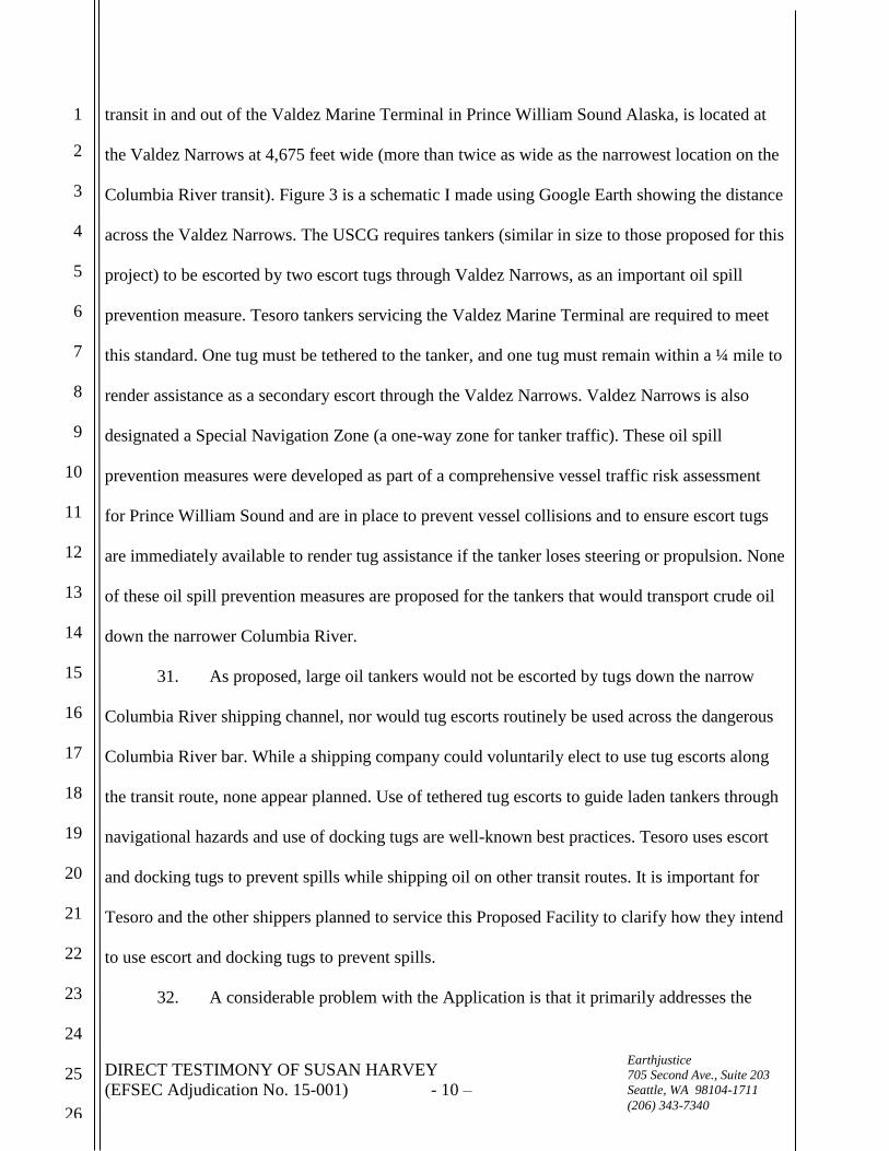
25
26
Earthjustice
705 Second Ave., Suite 203
Seattle, WA 98104-1711
(206) 343-7340
BEFORE THE STATE OF WASHINGTON
ENERGY FACILITY SITE EVALUATION COUNCIL
In the Matter of:
Application No. 2013-01
TESORO SAVAGE, LLC
VANCOUVER ENERGY DISTRIBUTION
TERMINAL
)
)
)
)
)
)
)
)
)
CASE NO. 15-001
DIRECT TESTIMONY OF
SUSAN L. HARVEY
I, Susan L. Harvey, of Eagle River, Alaska, declare under oath that I have personal
knowledge of the following:
1. I am over 18 years of age, and I am competent to testify.
2. This testimony addresses technical issues relevant to the application for a Site
Certification Agreement (Application) for the proposed construction and operation of the Tesoro
Savage Vancouver Energy Distribution Terminal (Proposed Facility). The Applicant is Tesoro
Savage Petroleum Terminal LLC (Applicant).
3. This testimony is based on my review of documents filed in the case and
publically available information, as well as my professional opinion based on my training and
experience in, and knowledge of, the petroleum industry.
I. EXPERIENCE AND INTRODUCTION
4. I have over 29 years of experience as a Petroleum and Environmental Engineer,
working on environmental issues and oil and gas projects. I own Harvey Consulting, LLC, a
consulting firm providing technical and regulatory compliance advice, analysis, and support to
DIRECT TESTIMONY OF SUSAN HARVEY
(EFSEC Adjudication No. 15-001) - 2 –
1
2
3
4
5
6
7
8
9
10
11
12
13
14
15
16
17
18
19
20
21
22
23
24
25
26
Earthjustice
705 Second Ave., Suite 203
Seattle, WA 98104-1711
(206) 343-7340
clients in the United States and abroad.
5. I served as a senior manager for the Alaska Department of Environmental
Conservation in the Division of Spill Prevention and Response providing oil spill prevention and
response regulatory oversight of the entire State of Alaska’s oil exploration, production, storage
and transportation system, including oil terminals and tankers, similar to the equipment proposed
for the Tesoro Savage Vancouver Energy Distribution Terminal Application. I managed 30 staff
in four offices, including inspectors, engineers, and scientists. I was responsible for the review of
hundreds of Oil Discharge Prevention and Contingency Plans in the state, facility inspections, oil
spill response drills, and compliance and enforcement for all regulated facilities and vessels
across Alaska.
6. I have held engineering and supervisory positions at both Arco and BP including
Prudhoe Bay Engineering Manager and Exploration Manager. I have planned, engineered,
executed, and managed both on and offshore exploration and production operations, and have
been involved in the drilling, completion, stimulation, testing, and oversight of hundreds of wells
and the design of oil production, storage, and pipeline facilities.
7. I participated on oil spill response teams when working for the petroleum
industry, have authored Oil Spill Prevention and Response Plans, have completed critical
analysis of Oil Spill Prevention and Response Plans as a regulator and a consultant to
recommend improvements, and have conducted and evaluated numerous oil spill response drills
and exercises both as regulator and as a consultant.
8. My experience also includes air and water pollution abatement design and
execution, best management practices, environmental assessment of oil and gas project impacts,
and oil spill prevention and response planning.

DIRECT TESTIMONY OF SUSAN HARVEY
(EFSEC Adjudication No. 15-001) - 3 –
1
2
3
4
5
6
7
8
9
10
11
12
13
14
15
16
17
18
19
20
21
22
23
24
25
26
Earthjustice
705 Second Ave., Suite 203
Seattle, WA 98104-1711
(206) 343-7340
9. I served as a University of Alaska Professor in the Masters of Engineering
Department, providing instruction on best technology and practice for oil and gas development
and pollution abatement.
10. My work has included oil and gas projects in Alaska, New York, Pennsylvania,
Ohio, West Virginia, Colorado, Texas, New Mexico, California, and Oklahoma, as well as in
Canada, Australia, Russia, Greenland, Belize, and Norway.
11. I have authored numerous technical reports related to oil spill prevention and
response planning, oil and gas project construction, operation, and abandonment, including best
practices for oil and gas well construction, air and water pollution abatement design and
execution, environmental assessments of oil and gas projects.
12. I hold a Master of Science in Environmental Engineering and a Bachelor of
Science in Petroleum Engineering. My resume is attached to this testimony.
13. I reviewed the following documents in the course of preparing this testimony:
August 2013, Tesoro Savage Vancouver Energy Distribution Terminal
Application for Site Certification Agreement, Application No. 2013-01;
February 2014 Supplement to the Tesoro Savage Vancouver Energy Distribution
Terminal Application for Site Certification Agreement Application No. 2013-01
of August 2013;
July 2014 Tesoro Savage Vancouver Energy Distribution Terminal Preliminary
Draft Environmental Impact Statement (PDEIS);
November 2015 State of Washington, Energy Facility Site Evaluation Council’s
Draft Environmental Impact Statement (DEIS) for the Tesoro Savage Vancouver

DIRECT TESTIMONY OF SUSAN HARVEY
(EFSEC Adjudication No. 15-001) - 4 –
1
2
3
4
5
6
7
8
9
10
11
12
13
14
15
16
17
18
19
20
21
22
23
24
25
26
Earthjustice
705 Second Ave., Suite 203
Seattle, WA 98104-1711
(206) 343-7340
Energy Distribution Terminal Application for Site Certification Agreement
Application No. 2013-01; and
January 2015, Vancouver Energy comments to the Council on the DEIS.
14. The focus of this testimony is on the oil spill risks and consequences to the
Columbia River and Pacific Ocean from Proposed Facility and railcars and tankers that will
service the facility. In this testimony, I will also provide an analysis of the shortfall in the oil spill
response plans and capability currently offered by the Applicant.
II. PROPOSED ACTION POSES A SIGNIFICANT RISK OF SPILLING OIL TO WATER
THAT COULD BE AVOIDED.
A. Proposed Action Poses High Risk of Spill to Water
15. The Proposed Action poses a significant risk of spilling oil to water that could be
avoided by not building the project.
16. The Applicant proposes to build a crude-by-rail terminal on the banks of the
Columbia River, an area prone to both volcanic eruption hazards and earthquakes. This site has a
moderate to high risk of liquefaction during an earthquake.1 Combined, these natural hazards
pose a significant risk of storage tanks and/or secondary containment system failure resulting in a
catastrophic oil spill of one or more tank’s oil released into the Columbia River.2 Placement of
large storage tanks filled with 360,000 barrels of oil on the bank of an environmentally sensitive
river can be avoided by not building the project.
17. The Proposed Facility would require tankers to transport oil down the Columbia
River and over the Pacific Ocean to California, Washington, Hawaii, and Alaska for delivery to a
1 Ex0051-000000-PCE, DEIS, Chapter 3, November 2015, page 3.1-10, 3.1-16; Ex0003-000000-
PCE, Tesoro Savage Vancouver Energy Distribution Terminal, Revised Application, February
2014, Volume 2, PDF Page 593 of 1604.
2 Ex0003-000000-PCE, Tesoro Savage Vancouver Energy Distribution Terminal Application
No. 2013-01 Supplement, February 2014, Page 3-246.

DIRECT TESTIMONY OF SUSAN HARVEY
(EFSEC Adjudication No. 15-001) - 5 –
1
2
3
4
5
6
7
8
9
10
11
12
13
14
15
16
17
18
19
20
21
22
23
24
25
26
Earthjustice
705 Second Ave., Suite 203
Seattle, WA 98104-1711
(206) 343-7340
refinery. Tankers would be filled with up to 600,000 barrels (in the largest tanker) and would be
required to navigate the very narrow 300-foot-wide, 43 feet deep outbound lane of a 600-foot-
wide shipping channel, for 105 miles down the Columbia River. To exit the Columbia River and
reach the Pacific Ocean, the laden tanker must cross a dangerous navigational hazard (a 2,640-
foot-wide and 5-mile-long sand bar at the mouth of the Columbia River), and navigate marine
waters of the Pacific Ocean to reach facilities in Hawaii, Alaska, California and Washington.3
18. Washington State Department of Ecology review of this application identified
laden oil tankers as one of the highest risks for a catastrophic oil spill in Washington waters. The
Proposed Facility poses a new risk because there are currently no large oil tankers carrying crude
oil on the Columbia River to the 105-mile distance to the Vancouver Terminal.4 The Washington
State Department of Ecology concluded:
Currently there are no large tank ships that carry crude oil on the Columbia
River the 105-mile distance to the Vancouver/Portland Terminals. This new
operation involving the transport of crude oil will result in a significant change
in the volume and type of oil moved on the Columbia River. Laden tank ships
represent one of the highest risks for a catastrophic oil spill in Washington
waters. Discussion should be added as to how the risk of oil spills will be
assessed and minimized/mitigated. Suggest assessment of pilotage and escort
requirements for tank ships in northern Puget Sound required under RCW
88.16.190. Also review RCW 90.56.005 to view legislative findings on zero
spills policy for the state.” (Sean Orr, Ecology Spills Preparedness Program)5
[Emphasis added].
19. The United States Coast Guard (USCG) operates the Puget Sound Tanker Traffic
Service (VTS) to provide navigational assistance and a traffic separation scheme that includes
3 http://www.columbiariverbarpilots.com.
4 Ex5502-000242-CRK, DNV – GL, Vancouver Energy Terminal Quantitative Vessel Traffic
Risk Assessment, Report No. PP111860-2, Rev. 5, January 20, 2016. Page 5, PDF Page 23 of
242.
5 Ex5501-000054-CRK, Applicants Responses to EFSEC and Agency Review Comments, Jan.
2014 at 18, Issue 74.

DIRECT TESTIMONY OF SUSAN HARVEY
(EFSEC Adjudication No. 15-001) - 6 –
1
2
3
4
5
6
7
8
9
10
11
12
13
14
15
16
17
18
19
20
21
22
23
24
25
26
Earthjustice
705 Second Ave., Suite 203
Seattle, WA 98104-1711
(206) 343-7340
buoys and charted traffic lanes. VTS Puget Sound manages the commercial shipping lanes from
Cape Flattery through the Strait of Juan de Fuca to Tacoma.
20. The USCG does not have a tanker traffic system to monitor and guide ships
through the very narrow 600-foot-wide Columbia River shipping lane.6 There is no requirement
for a tanker operator to use escort tugs to safely navigate the river. The Application’s
socioeconomic analysis includes an “expectation,” but not a guarantee that each tanker will use
two tugs to dock and undock the tanker.7 The DEIS assumes tug escorts would be used to dock
and undock tankers at the Proposed Facility, yet, there is no guaranteed commitment to use tugs
in the Application.8 Furthermore, the Applicant’s most recent summary of mitigation measures
proposed does not include a commitment to use tugs to dock and undock the tankers.9
21. The largest tankers, laden with up to 600,000 barrels of oil, and up to 899 feet in
length and 157.5 feet wide, would transit down the narrow 300-foot-wide, 43 feet deep outbound
lane of the 600-foot-wide shipping channel, using more than half the 300-foot lane.10
There
would be minimal vessel traffic separation. Two tankers passing each other in this narrow
shipping channel would only be separated by a few hundred feet. The risk of a collision
6 Washington States Boating Handbook, https://www.boat-
ed.com/washington/handbook/page/65/Vessel-Traffic-Systems-and-Shipping-Lanes/.
7 Ex0003-000000-PCE, Tesoro Savage Vancouver Energy Distribution Terminal Application
No. 2013-01 Supplement, February 2014, Page 4-497.
8 Ex0051-000000-PCE, DEIS, Chapter 2, November 2015, Pages 2-49 and 2-50.
9 Ex5503-000015-CRK, Attachment ES-1 to the Applicants January 22, 2016 Comments on
DEIS.
10 The beam of a 160,000 DWT tanker (the largest tanker) is 157.5 feet. Ex0003-000000-PCE,
Tesoro Savage Vancouver Energy Distribution Terminal Application No. 2013-01 Supplement,
February 2014, Page 4-456. Table 4.3-8i; Applicant states that administrative controls will limit
loading to 600,000-barrel maximum. Ex5504-000326-CRK, Vancouver Energy Comments on
the Draft Environmental Impact Statement, Submitted to EFSEC, January 22, 2016, Appendices,
Page 23 of 30.

DIRECT TESTIMONY OF SUSAN HARVEY
(EFSEC Adjudication No. 15-001) - 7 –
1
2
3
4
5
6
7
8
9
10
11
12
13
14
15
16
17
18
19
20
21
22
23
24
25
26
Earthjustice
705 Second Ave., Suite 203
Seattle, WA 98104-1711
(206) 343-7340
increases as separation distance decreases.
22. Figure 1 is a schematic I made using Google Earth that includes a snapshot of the
Columbia River near Prescott. Tankers that travel between the mouth of the Columbia River to
the port of Vancouver, Washington pass by Prescott. As measured using Google Earth software,
the river is approximately 1966 feet wide from the shore to the edge of a vessel dock along the
other shore at this point on the river. A 730-foot-long, 104-foot-wide vessel was traveling the
river when this image was collected by Google. On Figure 1, I drew a blue tanker shaped
polygon to represent a vessel that is 899 feet long and 157.5 feet wide (the largest tanker
planned), placing it alongside the other vessel in the narrow 600-foot-wide shipping channel. If
both tankers are 157.5 feet wide, there would be only be a 285-foot separation between tankers,
as shown by the small white arrow between the vessels. This is a very high risk navigation plan,
where the outbound tanker laden with up to 600,000 barrels of oil (25,200,000 gallons), would
come within 285 feet of another large tanker traveling inbound. Loss of steering or propulsion, or
human navigation error would result in a high probability of vessel collision or grounding.
23. Figure 2 is a schematic I made using Google Earth that includes a snapshot of the
Columbia River near Pearcy Island. Tankers that travel between the mouth of the Columbia
River to the port of Vancouver, Washington pass by Pearcy Island and through a number of
narrow sections similar to the one shown on this map. As measured using Google Earth software,
the river is only approximately 1,928 feet wide from the shore to shore, leaving approximately
664 feet on either side of the 600-foot-wide shipping lane. The narrow width of the river
provides little or no room for navigation error, and insufficient time to react to a loss of vessel
steering or propulsion for a tanker operating without a tug escort.
24. I reviewed the entire transit route from the mouth of the Columbia River to the

DIRECT TESTIMONY OF SUSAN HARVEY
(EFSEC Adjudication No. 15-001) - 8 –
1
2
3
4
5
6
7
8
9
10
11
12
13
14
15
16
17
18
19
20
21
22
23
24
25
26
Earthjustice
705 Second Ave., Suite 203
Seattle, WA 98104-1711
(206) 343-7340
Proposed Facility location at the Port of Vancouver on Google Earth. Over this 105-mile
distance, the river is very narrow in spots, less than 2,000 feet wide (less than ½ mile wide), with
a very narrow shipping lane of just over 1/10th
of a mile wide, leaving only a few hundred feet of
vessel separation. This narrow, shallow river is not an optimal location for large oil tankers to
routinely transit.
25. The Applicant plans to use state licensed Columbia River Pilots to navigate laden
tankers 75 miles down the river to Astoria, where Columbia River Bar Pilot will board and
navigate the vessel from Astoria to the Columbia River Bar to the sea.11
While the use of a river
pilot is an important, and valued, spill prevention measure, it does not supplant the need for other
oil spill prevention measures. A comprehensive vessel traffic risk assessment is need to identify
hazards, evaluate the benefits of a vessel traffic system, use of one-way traffic lanes in high risk
sections of the river, and tug escorts, among other risk reduction measures.
26. The Applicant did not include a comprehensive vessel traffic risk assessment in
its original application, or PDEIS. It was not until January 22, 2016 that the Applicant provided
the Council with a “Quantitative Vessel Traffic Risk Assessment” prepared by DNV-GL. The
DNV-GL study did not complete a comprehensive assessment of all possible risk reduction
mitigation measures that could be implemented, but did examine the risk reduction benefit of a
tethered tug escort.
27. DNV-GL’s Vessel Traffic Risk Assessment relies on the Columbia River Pilots to
avoid a collision. DNV-GL’s worldwide research estimates a 26% reduction in collision
frequency and a 51% reduction of incident frequency for a powered grounding where pilots were
used. The DNV study confirms collisions and groundings are a risk, and that while the use of
11
Ex5502-000242-CRK, DNV – GL, Vancouver Energy Terminal Quantitative Vessel Traffic
Risk Assessment, Report No. PP111860-2, Rev. 5, January 20, 2016. Page iv.

DIRECT TESTIMONY OF SUSAN HARVEY
(EFSEC Adjudication No. 15-001) - 9 –
1
2
3
4
5
6
7
8
9
10
11
12
13
14
15
16
17
18
19
20
21
22
23
24
25
26
Earthjustice
705 Second Ave., Suite 203
Seattle, WA 98104-1711
(206) 343-7340
pilots reduces collision and grounding risk, that risk is not eliminated.12
28. DNV-GL evaluated the risk reduction benefit of tethering a tug escort to a tanker
laden with oil in a tug-bow-to-tanker-stern position from the terminal until Astoria, and use of a
sentinel tug escort to guide the tanker safely across the Columbia River Bar.13
Use of an escort
tug was estimated to reduce grounding incidents by 90%. Reductions in collision risk was not
quantified in this study; DNV-GL recommended further expert study on this point, but
anticipated escort tugs would also reduce collision risk.
29. This oil spill prevention measure was not proposed by the Applicant, nor is
currently included in its Application. Despite a 90% estimated reduction in grounding in the
DNV-GL study, the Applicant did not revise its Application to propose tethered escort tug use.
The Applicant’s most recent summary of mitigation measures proposed, does not include any use
of escort tugs at all, even to dock and undock the tankers.14
The Applicant’s comments on the
DEIS asserts it has “no control” over the vessels servicing its Proposed Facility.15
Tesoro
anticipates shipping approximately one-third of the crude oil, the other two-thirds would be
shipped by other companies. Therefore, it is unknown how, or if, tugs would be used by the other
tanker operators, transporting the other two-thirds of the crude oil to prevent oil spills. There is
no guarantee that escort and docking tugs (an oil spill prevention measure) will be consistently
use by any tanker operators servicing the Proposed Facility.
30. By comparison, the narrowest spot that tankers must navigated through on their
12
Ex5502-000242-CRK, – GL, Vancouver Energy Terminal Quantitative Vessel Traffic Risk
Assessment, Report No. PP111860-2, Rev. 5, January 20, 2016. Page 32.
13 Ex5502-000242-CRK, DNV – GL, Vancouver Energy Terminal Quantitative Vessel Traffic
Risk Assessment, Report No. PP111860-2, Rev. 5, January 20, 2016. Page 122, 132.
14 Ex5503-000015-CRK, Attachment ES-1 to the Applicant’s January 22, 2016 DEIS Comments.
15 Ex5504-000326-CRK, Tesoro Savage DEIS Comments. January 22, 2016, PDF Page 53 of
326.
DIRECT TESTIMONY OF SUSAN HARVEY
(EFSEC Adjudication No. 15-001) - 10 –
1
2
3
4
5
6
7
8
9
10
11
12
13
14
15
16
17
18
19
20
21
22
23
24
25
26
Earthjustice
705 Second Ave., Suite 203
Seattle, WA 98104-1711
(206) 343-7340
transit in and out of the Valdez Marine Terminal in Prince William Sound Alaska, is located at
the Valdez Narrows at 4,675 feet wide (more than twice as wide as the narrowest location on the
Columbia River transit). Figure 3 is a schematic I made using Google Earth showing the distance
across the Valdez Narrows. The USCG requires tankers (similar in size to those proposed for this
project) to be escorted by two escort tugs through Valdez Narrows, as an important oil spill
prevention measure. Tesoro tankers servicing the Valdez Marine Terminal are required to meet
this standard. One tug must be tethered to the tanker, and one tug must remain within a ¼ mile to
render assistance as a secondary escort through the Valdez Narrows. Valdez Narrows is also
designated a Special Navigation Zone (a one-way zone for tanker traffic). These oil spill
prevention measures were developed as part of a comprehensive vessel traffic risk assessment
for Prince William Sound and are in place to prevent vessel collisions and to ensure escort tugs
are immediately available to render tug assistance if the tanker loses steering or propulsion. None
of these oil spill prevention measures are proposed for the tankers that would transport crude oil
down the narrower Columbia River.
31. As proposed, large oil tankers would not be escorted by tugs down the narrow
Columbia River shipping channel, nor would tug escorts routinely be used across the dangerous
Columbia River bar. While a shipping company could voluntarily elect to use tug escorts along
the transit route, none appear planned. Use of tethered tug escorts to guide laden tankers through
navigational hazards and use of docking tugs are well-known best practices. Tesoro uses escort
and docking tugs to prevent spills while shipping oil on other transit routes. It is important for
Tesoro and the other shippers planned to service this Proposed Facility to clarify how they intend
to use escort and docking tugs to prevent spills.
32. A considerable problem with the Application is that it primarily addresses the

DIRECT TESTIMONY OF SUSAN HARVEY
(EFSEC Adjudication No. 15-001) - 11 –
1
2
3
4
5
6
7
8
9
10
11
12
13
14
15
16
17
18
19
20
21
22
23
24
25
26
Earthjustice
705 Second Ave., Suite 203
Seattle, WA 98104-1711
(206) 343-7340
crude-by-rail and terminal storage facility proposal because the Applicant plans to own and
operate the terminal; however, the terminal will be serviced by a host of unnamed shipping
companies, with unknown safety records, unknown navigational experience transiting the
Columbia River, unknown oil spill prevention plans, unknown tank vessel design, unknown tug
escort plans, and unconfirmed response capability. While Tesoro indicates the type of tankers it
might use to ship its oil, shipping plans are unknown for the other two-thirds of the oil. The
Applicant’s comments on the DEIS assert it has “no control” over the vessels servicing its
Proposed Facility.16
The Applicant proposes to vet ships before they enter the Columbia River to
load; however, the efficacy of this vetting system in preventing oil spills is unknown.
17 DNV-
GL’s study Vessel Traffic Risk Assessment Study prepared for the Applicant, assigned no
quantitative risk reduction measure to the proposed vetting system.18
33. In sum, the cumulative risk and consequences of tankers used to service this
facility is a critical component that is not well analyzed, nor is the risk adequately mitigated.
34. Laden tankers have grounded on the Columbia River. This is a genuine, and
serious risk. In 1984, MOBILOIL tanker (a 618-foot tanker) loaded with oil lost steering due to
an equipment malfunction and grounded on the Columbia River approximately one (1) mile
upstream from Saint Helens, Oregon.19
Saint Helens Oregon is located at approximately mile 86
on the Columbia River, approximately 19 miles downstream of the Proposed Facility. The tanker
16
Ex5504-000326-CRK, Tesoro Savage DEIS Comments. January 22, 2016, PDF Page 53 of
326.
17 Ex5502-000242-CRK, – GL, Vancouver Energy Terminal Quantitative Vessel Traffic Risk
Assessment, Report No. PP111860-2, Rev. 5, January 20, 2016. Page 11.
18 Ex5502-000242-CRK, DNV – GL, Vancouver Energy Terminal Quantitative Vessel Traffic
Risk Assessment, Report No. PP111860-2, Rev. 5, January 20, 2016. Page 40.
19 NOAA, Fate and Effects of the MOBILOIL Spill in the Columbia River, 1985,
https://archive.org/stream/fateeffectsofmob00kenn#page/n1/mode/2up.

DIRECT TESTIMONY OF SUSAN HARVEY
(EFSEC Adjudication No. 15-001) - 12 –
1
2
3
4
5
6
7
8
9
10
11
12
13
14
15
16
17
18
19
20
21
22
23
24
25
26
Earthjustice
705 Second Ave., Suite 203
Seattle, WA 98104-1711
(206) 343-7340
grounding took place in a section of the Columbia River that is approximately 3,200 feet wide as
measured on Google Earth. NOAA estimated that approximately 3,925 barrels (164,850 gallons)
of oil leaked into the river. Most of the oil was rapidly transported down the river within 2-3
days20
and swept out to sea unrecovered.21
The impact area was mapped by NOAA and is shown
in Figure 10.
35. The 1984 MOBILOIL tanker oil spill is evidence that loss of vessel steering in the
narrow Columbia River can result in tanker grounding, and rupture of the oil storage tanks,
resulting in a spill into the Columbia River. This incident also showed that while the responsible
party attempted to clean up the spill, it was a futile effort, with NOAA reporting that most of the
oil was quickly transported down river by the swift Columbia River current. NOAA’s 1985 Fate
and Effect Study, reported adverse impacts as a result of a 3,925-barrel spill (approximately 14%
of the total cargo of 28,404 barrels), impacting birds, fish, wildlife, and the shorelines.22
The
MOBILOIL tanker oil spill of 3,925 barrels equates to a spill of only 0.7% proposed maximum
cargo here (600,000 barrels),23
only 1.2% of the most commonly planned tanker cargo size
(approximately 331,000 barrels),24
and 1.1% of the Proposed Facility Worst Case Discharge
(360,000 barrels). Clearly, a spill exceeding 1% of the proposed maximum cargo, or Proposed
Facility Worst Case Discharge would have an adverse impact. Therefore, substantially smaller
20
NOAA, Fate and Effects of the MOBILOIL Spill in the Columbia River, 1985,
https://archive.org/stream/fateeffectsofmob00kenn#page/n1/mode/2up, Page 34.
21 Ex0004-000000-PCE, Tesoro Savage Vancouver Energy Distribution Terminal PDEIS,
August 2014, Page 5-244.
22 NOAA, Fate and Effects of the MOBILOIL Spill in the Columbia River, 1985,
https://archive.org/stream/fateeffectsofmob00kenn#page/n1/mode/2up, Pages 6 and 38.
23 3,925 barrels (spilled in MOBILOIL incident)/600,000 barrels (largest tanker proposed for this
project, 165,000 DWT) = 0.7%.
24 3,925 barrels (spilled in MOBILOIL incident)/331,000 barrels (47,000 DWT tanker proposed
for this project) = 1.2%.

DIRECT TESTIMONY OF SUSAN HARVEY
(EFSEC Adjudication No. 15-001) - 13 –
1
2
3
4
5
6
7
8
9
10
11
12
13
14
15
16
17
18
19
20
21
22
23
24
25
26
Earthjustice
705 Second Ave., Suite 203
Seattle, WA 98104-1711
(206) 343-7340
amounts of oil, substantially less than the Worst Case Discharge, have been proven to have
adverse consequences.
36. The DNV-GL vessel traffic risk assessment prepared for the Applicant concludes
a tanker collision has a P90 probability (high-confidence) of releasing 102,500 barrels (for the
largest 165,000 DWT tankers), and 58,700 barrels (for the 47,000 DWT tankers) and releasing
31,900 barrels (for the largest 165,000 DWT tankers), and 20,200 barrels (for the 47,000 DWT
tankers)25
DNV-GL assumes that 17-18% of the oil is released in a collision case26
and 5-6% of
the oil is released in the grounding case.27
37. Compared to the 3,925 barrels released in the MOBILOIL tanker spill, the DNV-
GL study prepared for the Applicant predicts spill estimates of 20,200 barrels to 102,500 barrels,
equating to a spill volume of approximately five (5) to 26 times orders of magnitude larger.
38. If a tanker loaded with oil loses steering or propulsion transiting the Columbia
River, there is currently no commitment by the Applicant to ensure tankers servicing this
Proposed Facility will have an escort tug immediately available to influence a tankers speed and
course. Lack of a guaranteed tug escort commitment substantially increases the risk of a collision
with another ship, allision (a ship striking a stationary object), or grounding. Escort tugs are used
in a number of US ports to prevent disabled tankers from drifting aground in substantially wider
shipping channels with substantially larger vessel traffic separation distances, but are not
25
Ex5502-000242-CRK, DNV – GL, Vancouver Energy Terminal Quantitative Vessel Traffic
Risk Assessment, Report No. PP111860-2, Rev. 5, January 20, 2016. Page 86. The DNV-GL
study notes (Page 87) that its subject matter experts believe the grounding spill estimates are
high; DNV-GL provides no other quantitative analysis to support a lower estimate.
26 A spill of 102,500 barrels of a 600,000-barrel load is 17.1%. A spill of 58,700 barrels of a
330,945-barrel load is 17.7%.
27 A spill of 31,900 barrels of a 600,000-barrel load is 5.3%. A spill of 20,200 barrels of a
330,945-barrel load is 6.1%.

DIRECT TESTIMONY OF SUSAN HARVEY
(EFSEC Adjudication No. 15-001) - 14 –
1
2
3
4
5
6
7
8
9
10
11
12
13
14
15
16
17
18
19
20
21
22
23
24
25
26
Earthjustice
705 Second Ave., Suite 203
Seattle, WA 98104-1711
(206) 343-7340
included in this proposed Application, or committed to by shippers intending to service this
Proposed Facility.
39. Prior to reaching the Pacific Ocean, a tanker loaded with oil must cross a well-
known navigation hazard area called the “Columbia Bar.” The Columbia River Bar Pilots
describe the bar “as one of the most dangerous and challenging navigated stretches of water in
the world,” due to the volume of water flowing from the Columbia River and the force of impact
with North Pacific storms.28
Oregon reports that since 1792, approximately 2,000 large ships
have sunk in and around the Columbia Bar, giving this area the reputation as the “Graveyard of
the Pacific.”29
40. While the Applicant proposes to restrict laden tanker transit to a minimum 10 feet
of clearance across the bar, and use Columbia River Pilots. These prevention measures alone
would be insufficient in the case a tanker’s steering or propulsion is lost during the crossing. The
Columbia River discharges approximately 265,000 cubic feet of water per second (ft3/s) which is
equivalent to 171 billion gallons per day.30
This large discharge of water over the shallow bars
and shoals at the mouth of the Columbia River can generate large standing waves and very rough
sea states where the river meets the Pacific Ocean.
41. In an Associated Press article titled “Graveyard Guides,” a Columbia River Bar
Pilot is quoted as describing winter conditions of 60 knots and swells of 20 feet at the Columbia
River Bar as “fairly routine,” and that winds can exceed 70-80 knots and swells can be larger
28
http://www.columbiariverbarpilots.com.
29 Oregon Parks and Recreation Department, Graveyard of the Pacific Brochure.
30 U.S. Geological Survey, Department of the Interior, Water Fact Sheet, Largest Rivers in the
United States, 1990, Page 2 of 2. 1,000 ft3/s is equal to 646 million gallons per day.

DIRECT TESTIMONY OF SUSAN HARVEY
(EFSEC Adjudication No. 15-001) - 15 –
1
2
3
4
5
6
7
8
9
10
11
12
13
14
15
16
17
18
19
20
21
22
23
24
25
26
Earthjustice
705 Second Ave., Suite 203
Seattle, WA 98104-1711
(206) 343-7340
than 45 feet on the bar.31
42. The Applicant acknowledges that if the project is not built, there are other sources
of oil for US Refineries in Washington, California, Hawaii, and Alaska:
U.S. Refineries located along the West Coast would continue to received crude
oil from existing sources, i.e., domestic sources connected to existing overland
transportation systems capable of moving the crude oil the west coast, the
Alaska North Slope, and foreign sources.32
Yet, it seeks approval to build a terminal on the banks of the Columbia River (despite the well-
known earthquake and volcanic natural hazards in the area) requiring over-land transportation of
360,000 barrels of crude per day (on average) from in-land production locations (North Dakota
and Alberta Canada) and intentionally place this large volume of oil on the Columbia River with
swift currents and numerous navigational hazards, that could be completely eliminated by
continuation of overland transportation to West Coast refineries in Washington and California.
43. In its comments on the DEIS, the Applicant concludes the direct, indirect, and
cumulative impacts of not building the project would be similar to building the project.33
This is
incorrect. The Proposed Facility would require large oil tankers traveling down the Columbia
River and crossing the hazardous Columbia River Bar, placing oil on the Columbia River and
Pacific Ocean and adds at least two overwater transfers (terminal to tanker) and (tanker to
refinery) that are not required for overland transportation of oil (pipeline, rail, or truck). Transfer
steps increase the potential for spills associated with human error and mechanical failure at the
transfer point. Eliminating transfer steps reduces spill risk.
31
http://www.columbiariverbarpilots.com/columbiariverbarpilots_press_0305.html.
32 Ex0003-000000-PCE, Tesoro Savage Vancouver Energy Distribution Terminal Application
No. 2013-01 Supplement, February 2014, Page 2-214, PDF Page 372 of 826.
33 Ex5504-000326-CRK, Tesoro Savage DEIS Comments. January 22, 2016, PDF Page 271 of
326.

DIRECT TESTIMONY OF SUSAN HARVEY
(EFSEC Adjudication No. 15-001) - 16 –
1
2
3
4
5
6
7
8
9
10
11
12
13
14
15
16
17
18
19
20
21
22
23
24
25
26
Earthjustice
705 Second Ave., Suite 203
Seattle, WA 98104-1711
(206) 343-7340
44. The Applicant also intends to ship in-land oil from North Dakota and Canada
thousands of miles across the Pacific Ocean to refineries in Alaska and Hawaii. Alaska’s Cook
Inlet and North Slope oil production facilities are forecasted to continue producing oil over the
next several decades. Transporting crude oil by rail and vessel all the way from North Dakota
and Canada to Alaska not only increases the likelihood of on-land and on-water oil spills by
increasing the distance that a barrel of crude oil is transported from the point of production to a
refinery overland and water, but also substantially increases the carbon footprint to refine a
barrel of oil at Tesoro’s Alaska refinery.34
Hawaii refineries are already supplied by Alaska and
foreign sources of crude oil and that would continue during the planned 20-year life of this
facility.35
B. Worst Case Oil Tanker Spill
45. Any tanker over 400 gross tons must have a USCG Tanker Response Plan (VRP)
for oil and hazardous material spills. Any tanker over 300 gross tons must have Oregon and
Washington Tanker Response Plan for oil spills.36
46. Washington State requires an oil spill plan to be developed to respond to the
Worst Case Spill. WAC § 173-182-230(3)(b). The Worst Case Spill for a vessel is a spill of the
vessel entire cargo and fuel complicated by adverse weather conditions as defined at WAC §
173-182-030(67)(c).
47. The USCG requires an oil spill plan to be developed to respond to the Worst Case
34
Ex5505-000007-CRK, U.S. Energy Information Administration, Alaska State Profile and
Energy Estimates, October 15, 2015.
35 Ex5506-000009-CRK,U.S. Energy Information Administration, Hawaii State Profile and
Energy Estimates, October 15, 2015.
36 Ex5507-000001-CRK, Lower Columbia Region Harbor Safety Committee, Columbia River
Incident Management Guidelines 03.10.10, Page 7 of 16.

DIRECT TESTIMONY OF SUSAN HARVEY
(EFSEC Adjudication No. 15-001) - 17 –
1
2
3
4
5
6
7
8
9
10
11
12
13
14
15
16
17
18
19
20
21
22
23
24
25
26
Earthjustice
705 Second Ave., Suite 203
Seattle, WA 98104-1711
(206) 343-7340
Discharge. Title 33, Chapter I, Subchapter O, Part 155, Subpart D, Tank Vessel Response Plans
for Oil. The Worst Case Discharge means a discharge in adverse weather conditions of a vessel’s
entire oil cargo. 33 CFR § 155.1020.
48. State and federal regulations are based on the worst case spills that have occurred
in past history (the entire cargo), to ensure there is sufficient oil spill response personnel and
equipment available to clean up the worst case discharge that could occur. Vessels can and have
capsized releasing the entire cargo.
49. Vessels transiting the Columbia River have a 43-foot draft limit. The DEIS
estimated the worst-case spill volume to be 319,925 barrels for a Handymax Oil Tanker to
729,560 barrels for a Suezmax Oil Tanker Loaded with Bakken Crude Oil and a maximum of
635,220 barrels for a Suezmax Oil Tanker loaded with Diluted Bitumen.37
50. The Applicant’s 2014 application estimates the maximum capacity of the largest
160,00 Deadweight Tonnage38
Suezmax Oil Tanker to be 731,513 barrels.39
The Applicant’s
2014 Preliminary Draft Environmental Impact Statement (PDEIS) lists a worst case spill volume
of up to 700,000 barrels.40
However, the Applicant has requested an administrative control to
limit the maximum loading of any tanker at the Proposed Facility to 600,000 barrels.41
51. If the Applicant’s proposed administrative control to limit loading to 600,000
37
Ex0051-000000-PCE, DEIS, Appendix J, Vessel Spill Risk Analysis for EFSEC DEIS for
Vancouver Energy, Tables 3 and 4, Page 10.
38 Deadweight Tonnage represents the number of metric tons (1 metric ton equaling 2,240
pounds) that a vessel can transport of cargo, stores, and bunker fuel.
39 Ex0003-000000-PCE, Tesoro Savage Vancouver Energy Distribution Terminal Application
No. 2013-01 Supplement, February 2014, Page 4-456, Table 4.3-8i.
40 Ex0004-000000-PCE, Vancouver Energy Preliminary Draft Environmental Impact Statement
(PEIS), August 2014, Page 5-259.
41 Ex5504-000326-CRK, Vancouver Energy Comment to EFSEC on DEIS Tesoro Savage
Vancouver Energy Project, Application 2013-01, January 22, 2015.

DIRECT TESTIMONY OF SUSAN HARVEY
(EFSEC Adjudication No. 15-001) - 18 –
1
2
3
4
5
6
7
8
9
10
11
12
13
14
15
16
17
18
19
20
21
22
23
24
25
26
Earthjustice
705 Second Ave., Suite 203
Seattle, WA 98104-1711
(206) 343-7340
barrels would be accepted by Washington and the USCG, then the Worst Case Discharge from
the largest oil tanker would be 600,000 barrels.
52. The Applicant does not provide a consequence analysis for the 600,000-barrel
Worst Case Spill in its PDEIS.
53. The DEIS, Appendix J, Vessel Spill Risk Analysis estimates a 730,000 barrel
Bakken Crude Oil Worst Case Discharge spill from the largest type of tanker proposed to service
this facility would cover 224 miles of the Columbia River with a 0.1 mm thick fresh oil slick and
an area of 157 square miles by Day 5 (hour 120) of the spill response.42
This means the entire
Columbia River from the Proposed Facility location at Mile 105 would be contaminated with a
fresh oil slick 0.1mm thick all the way to the Pacific Ocean, and upstream above Mile 105 as
wind and storm conditions move the oil.
54. Even if only 17-18% of the oil is released in a collision case43
and 5-6% of the oil
is released in the grounding case,44
as DNV-GL assumes in its vessel risk analysis prepared for
the Applicant, the DEIS estimates that volume of oil would cover six (6) to 31 miles of river with
a 0.1 mm thick fresh oil slick, and the entire river downstream of the incident would be coated in
a sheen of oil.
55. While the Applicant critiques the Council’s oil spill trajectory analysis,45
it
doesn’t provide its own. Neither its Application, nor it PDEIS provide oil spill trajectory maps
showing the estimated impact of a Worst Case Tanker Spill.
42
Ex0051-000000-PCE, DEIS, Appendix J, November 2015, Tables 21 and 22, Page 22.
43 A spill of 102,500 barrels of a 600,000-barrel load is 17%. A spill of 58,700 barrels of a
330,945-barrel load is 17.7%.
44 A spill of 31,900 barrels of a 600,000-barrel load is 5%. A spill of 20,200 barrels of a 330,945-
barrel load is 6%.
45 Ex5504-000326-CRK, Vancouver Energy Comment to EFSEC on DEIS Tesoro Savage
Vancouver Energy Project, Application 2013-01, January 22, 2015, PDF Page 281 of 326.

DIRECT TESTIMONY OF SUSAN HARVEY
(EFSEC Adjudication No. 15-001) - 19 –
1
2
3
4
5
6
7
8
9
10
11
12
13
14
15
16
17
18
19
20
21
22
23
24
25
26
Earthjustice
705 Second Ave., Suite 203
Seattle, WA 98104-1711
(206) 343-7340
C. Worst Case Facility Spill
56. Washington State requires an oil spill plan to be developed to respond to the
Worst Case Spill from an onshore facility, as defined at WAC § 173-182-030(67)(b):
For an onshore facility, the entire volume of the largest above ground storage
tank on the facility site complicated by adverse weather conditions, unless
Ecology determines that a larger or smaller volume is more appropriate given a
particular facility’s site characteristics and storage, production, and transfer
capacity.
57. The Environmental Protection Agency (EPA) requires a Spill Prevention Control
and Countermeasure (SPCC) Plan to be developed to respond to the Worst Case Discharge from
an onshore facility that, because of its location, can be expected to cause substantial harm to the
environment by discharging oil into or on the navigable waters or adjoining shorelines pursuant
to 40 CFR § 112.20(e) and 40 CFR §112.20(f)(1).46
58. Oil at the proposed terminal would be stored in six, double-bottom, internal
floating-roof above ground storage tanks that are 48 feet high and 240 feet in diameter with a
shell capacity of 380,000 barrels each.47
The Applicant plans to store a maximum of 360,000
barrels in each tank.48
The oil storage tanks would be built on the banks of the Columbia River.
The topography at this location would result in a spill reaching the river, if a tank and secondary
containment failure occurred, for example, during a large earthquake.49
59. The Applicant’s January 2014 Preliminary SPCC plan does not include any
46
Ex0003-000000-PCE, Tesoro Savage Vancouver Energy Distribution Terminal, Preliminary
Spill Prevention Control and Countermeasure Plan, (Application App.B.2) January 2014, Page 5.
47 Ex0003-000000-PCE, Tesoro Savage Vancouver Energy Distribution Terminal, Preliminary
Spill Prevention Control and Countermeasure Plan, January 2014, Page 11.
48 Ex0003-000000-PCE, Tesoro Savage Vancouver Energy Distribution Terminal, Preliminary
Spill Prevention Control and Countermeasure Plan, January 2014, Page B-3.
49 Ex0003-000000-PCE, Tesoro Savage Vancouver Energy Distribution Terminal, Preliminary
Spill Prevention Control and Countermeasure Plan, January 2014, Page A-11.

DIRECT TESTIMONY OF SUSAN HARVEY
(EFSEC Adjudication No. 15-001) - 20 –
1
2
3
4
5
6
7
8
9
10
11
12
13
14
15
16
17
18
19
20
21
22
23
24
25
26
Earthjustice
705 Second Ave., Suite 203
Seattle, WA 98104-1711
(206) 343-7340
description of the consequences of the Worst Case Discharge, does not include oil spill trajectory
maps showing the potential route the spilled oil would take, or the magnitude of impact that
would occur along the Columbia River. The SPCC plan does not show any oil spill response
capability at all. The SPCC plan defers these issues to the Washington Oil Spill Contingency
Plan.50
60. The Applicant’s January 2014 Preliminary Oil Spill Contingency Plan is based on
a Worst Case Spill of 15,540,000 gallons (370,000 barrels).51
Later in the Applicant’s January
2014 Preliminary Oil Spill Contingency Plan, the Applicant limits the Worst Case Spill based on
a proposed administrative control of limiting the fill of each 380,000-barrel tank to a maximum
of 360,000 barrels (15,120,000 gallons).52
61. Washington State classifies a spill of more than 1,000,000 gallons a catastrophic
spill.53
Therefore a leak of just 7% of one storage tank54
would equate to a catastrophic spill.
While the Applicant denies the likelihood of a tank and containment failure during an
earthquake, it is important to note that it does not even take a leak of an entire tank to trigger
Washington State’s catastrophic spill threshold of 1,000,000 gallons. A catastrophic spill to the
Columbia River could occur, by a combination of a weld failure or corrosion related leak, and a
secondary containment liner crack or damage or an unmitigated transfer spill.
50
Ex0003-000000-PCE, Tesoro Savage Vancouver Energy Distribution Terminal, Preliminary
Spill Prevention Control and Countermeasure Plan, January 2014, Page 14.
51 Ex0003-000000-PCE, Tesoro Savage Vancouver Energy Distribution Terminal, Preliminary
Oil Spill Contingency Plan (Application App.B.3), January 2014, Page 1-9.
52 Ex0003-000000-PCE, Tesoro Savage Vancouver Energy Distribution Terminal, Preliminary
Oil Spill Contingency Plan, January 2014, Page D-12.
53 Ex0003-000000-PCE, Tesoro Savage Vancouver Energy Distribution Terminal, Preliminary
Oil Spill Contingency Plan, January 2014, Page 2-50.
54 1,000,000 gallons = a catastrophic spill. 1,000,000 gallons/15,120,000 gallons per storage tank
is 7%.

DIRECT TESTIMONY OF SUSAN HARVEY
(EFSEC Adjudication No. 15-001) - 21 –
1
2
3
4
5
6
7
8
9
10
11
12
13
14
15
16
17
18
19
20
21
22
23
24
25
26
Earthjustice
705 Second Ave., Suite 203
Seattle, WA 98104-1711
(206) 343-7340
62. The Applicant’s Preliminary Oil Spill Contingency Plan, Application and PDEIS
do not include oil spill trajectory maps showing the potential route the spilled oil would take, or
the magnitude of impact that would occur along the Columbia River. The Applicant’s
Preliminary Oil Spill Contingency Plan only states that “Tesoro will plan to respond to a spill for
[a] distance from 5 miles upstream and downstream to the mouth to the Columbia River”
indicating that the Applicant anticipates a Worst Case Discharge from the tanks (360,000 barrels)
would contaminate at least 110 miles (5 miles upstream and 105 miles downstream) based on the
swift Columbia River current that will likely rapidly transport oil downstream at a rate of 1 to 7
knots.55
63. The DEIS documents that Washington requires contingency planning for a worst
case spill of the largest storage tank, or larger at Washington’s discretion, but omits a specific
tank failure consequence analysis for a 360,000-barrel spill based on the assumption that the tank
and secondary containment system would not fail during a massive earthquake.56
64. While the Council’s DEIS did not specifically analyze the spill trajectory for a
complete loss of one tank into the Columbia River during an earthquake event, the trajectory
impacts can be deduced from the Council’s oil spill trajectory work completed for a tanker spill
of 360,000 barrels. The Council estimated a 360,000-barrel vessel spill of Bakken Crude oil
would cover 110 miles of the Columbia River with a 0.1 mm thick fresh oil slick and an area of
77 square miles by Day 5 (hour 120) of the spill response.57
This means the entire Columbia
River from the Proposed Facility location at Mile 105 would be contaminated with a fresh oil
55
Ex0003-000000-PCE, Tesoro Savage Vancouver Energy Distribution Terminal, Preliminary
Oil Spill Contingency Plan, January 2014, Page D-52.
56 Ex0051-000000-PCE, DEIS, Chapter 4, Potential Accidents for EFSEC DEIS for Vancouver
Energy, November 2015, Pages 4-25 and 4-26.
57 Ex0051-000000-PCE, DEIS, Appendix J, November 2015, Tables 21 and 22, Page 22.

DIRECT TESTIMONY OF SUSAN HARVEY
(EFSEC Adjudication No. 15-001) - 22 –
1
2
3
4
5
6
7
8
9
10
11
12
13
14
15
16
17
18
19
20
21
22
23
24
25
26
Earthjustice
705 Second Ave., Suite 203
Seattle, WA 98104-1711
(206) 343-7340
slick 0.1 mm thick all the way to the Pacific Ocean, and upstream above Mile 105 as the wind
and storm conditions move the oil.
65. Not building this facility would have substantially less direct, indirect, and
cumulative impacts to water by eliminating over water transfers from the Proposed Facility to
tankers servicing the facility and by eliminating the risk of a catastrophic oil spill to the
Columbia River and Pacific Ocean during an earthquake.
D. Worst Case Railroad Spill
66. The Proposed Project anticipates rail deliveries of 120 car trains with 100-118 of
the cars filled with 750 barrels per car (31,500 gallons each).58
In 2015, Washington completed a
Washington State Marine & Rail Oil Transportation Study that identified (1) federal contingency
plans for railroads transporting oil in bulk are insufficient to mitigate the potential risk, (2) the
need for more funding for spill prevention, preparedness and response oversight of the railroad
oil traffic (3) the need to revise the definition of facility in Washington State statute to include
moving trains carrying oil as cargo, (4) the need for Washington State Department of Ecology to
develop regulations that require rail oil spill contingency plans and participation in drills, and (5)
the need to establish financial responsibility for oil handling facilities including rail
transportation.59
67. Federal regulations (49 CFR § 130.31) require a very basic oil spill response plan
for rail cars with a capacity of 3,500 gallons or more each. Comprehensive oil spill response
plans are only required for railcars with individual capacities of 42,000 gallons or more each,
58
Ex0051-000000-PCE, DEIS, Chapter 2, Proposed Action and Alternatives, November 2015,
Page 2-1.
59 Ex0064-000570-PCE, Washington State Department of Ecology, Washington State Marine &
Rail Oil Transportation Study Findings & Recommendations, Publication Number: 15-08-010,
March 1, 2015, Pages 21 and 22.
DIRECT TESTIMONY OF SUSAN HARVEY
(EFSEC Adjudication No. 15-001) - 23 –
1
2
3
4
5
6
7
8
9
10
11
12
13
14
15
16
17
18
19
20
21
22
23
24
25
26
Earthjustice
705 Second Ave., Suite 203
Seattle, WA 98104-1711
(206) 343-7340
meaning the more stringent comprehensive planning requirements would not apply to the
proposed railcar traffic associated with this project. The difference between a basic and
comprehensive response plan is significant. A basic plan does not include: (1) requirements of
the National Contingency Plan (40 CFR § 300) and Area Contingency Plans, (2) a Qualified
Individual with the full authority to implement and financially authorize the removal action, (3)
evidence of contracts with personnel and equipment to remove the Worst Case Discharge, and
(4) written training and drill programs.
68. The DEIS lists oil spill prevention standards that have been voluntarily adopted
by railroad operator BNSF, that go beyond the minimum federal standard. There is no guarantee
that BNSF’s voluntary standards will be adhered to during the life of the facility.
69. The Proposed Project anticipates rail deliveries of 100-118 cars of 750 barrels per
car (31,500 gallons each) that could travel along several different major railroad routes to reach
Vancouver. The Columbia River alignment route increases the risk of spilling oil to water for
over 100 miles, as the railroad corridor comes very close to the river (within 30-40 feet in many
locations) and crosses the river as it heads west towards Vancouver.60
70. Figures 4-9 are schematics I made using Google Earth to show how close the
railroad alignment is along the Columbia River east of the Proposed Facility, and to show that
the railroad crosses the river in several locations. The railcar spill would impact the river in these
locations, and others where the railroad is close to the river or crosses the river.
71. Neither the Applicant’s Preliminary Oil Spill Contingency Plan, PDEIS, or DEIS
include oil spill trajectory maps showing the potential route the spilled oil would take, or the
magnitude of impact that would occur along the Columbia River.
60
Ex0051-000000-PCE, DEIS, Chapter 2, Proposed Action and Alternatives, November 2015,
Page 2-1.

DIRECT TESTIMONY OF SUSAN HARVEY
(EFSEC Adjudication No. 15-001) - 24 –
1
2
3
4
5
6
7
8
9
10
11
12
13
14
15
16
17
18
19
20
21
22
23
24
25
26
Earthjustice
705 Second Ave., Suite 203
Seattle, WA 98104-1711
(206) 343-7340
72. The Proposed Project anticipates rail deliveries of 100-118 cars of 750 barrels per
car (31,500 gallons each). If one-third of this train load of 120 cars was involved in an accident,
and 32 rail cars loaded with 31,500 gallons each spilled into the Columbia River, along the river
corridor alignment, it would produce a catastrophic spill of more than 1,000,000 gallons.
E. Cumulative Oil Spill Impacts
73. Neither the Applicant’s Application or its PDEIS provides a quantitative
cumulative oil spill risk and hazard risk assessment that combines the terminal, rail, and tanker
risk.
74. Instead, Chapter 7 (Cumulative Impacts) of the Applicant’s PDEIS provides a
very general description of the cumulative oil spill impact trends, that varies between concluding
a significant spill could result in a significant impact to fish and water resources, to unsupported
conclusions that oil spills larger than 300,000 barrels spilled to the Columbia River would have
“minimal” impact and can be cleaned up leaving only a “trace.”
75. For example, the Applicant acknowledges there is a potential for cumulative
impact to surface and ground water resources from a railcar or vessel spill and to fisheries:
Not all incidents damage a rail car or vessel such that a release occurs.
Nevertheless, serious incidents can occur where a sizeable volume of crude oil
can be released. In such instances, the crude oil may be introduced into surface
water resources in addition to all other pollutant sources, resulting in a
cumulative impact. The duration of such an impact may be short or long term,
depending on the particular conditions of the spill and how they interrelate to the
receiving surface water.61
[Emphasis added.]
The increased rail transportation of crude oil under the Proposed Action and
reasonably foreseeable projects would increase the potential risk for an incident
and spill, and resulting potential impacts to fisheries.62
[Emphasis added.]
61
Ex0004-000000-PCE, Vancouver Energy Preliminary Draft Environmental Impact Statement
(PDEIS), August 2014, Pages 7-28.
62 Ex0004-000000-PCE, Vancouver Energy Preliminary Draft Environmental Impact Statement
(PDEIS), August 2014, Pages 7-31.

DIRECT TESTIMONY OF SUSAN HARVEY
(EFSEC Adjudication No. 15-001) - 25 –
1
2
3
4
5
6
7
8
9
10
11
12
13
14
15
16
17
18
19
20
21
22
23
24
25
26
Earthjustice
705 Second Ave., Suite 203
Seattle, WA 98104-1711
(206) 343-7340
76. Yet, the Applicant minimizes the cumulative impact potential by concluding, that
oil spill recovery will be highly efficient leaving only a trace of oil.
Although response activities can recover a substantial amount of the release,
under certain circumstances traces of pollutants from the crude oil may persist
in the surface water environment over a longer period.63
[Emphasis added.]
77. The Applicant’s PDEIS concludes the cumulative impact of an oil spill larger than
300,000 barrels would be “minimal” as long as more work is done to increase the vessel
planning standard.
…the Lower Columbia River GRP standard would need to be increased from
300,000 bbl to 700,000 bbl for the volumes anticipated to be loaded to the vessels
mooring under the Proposed Action. With the implementation of this higher
planning standard cumulative impacts resulting from vessel transportation of
crude oil on the Columbia River would be minimal.64
[Emphasis added.]
This conclusion is not rational. A spill of 300,000 barrels or more into a freshwater river, like the
Columbia River, would have major adverse consequences, not “minimal.” As explained further
in below, a 1,100,000 gallon (26,190 barrel) spill of diluted bitumen (a fraction of the spill size
possible for this Proposed Facility) was released from the Enbridge Energy Pipeline into
Michigan’s Kalamazoo River in 2010 contaminating 40 miles of the river. Kalamazoo River oil
spill recovery operations persisted for over 4 years, with the main focus an attempt to clean up
submerged oil contamination that persists even today. Certainly, a spill of several hundred
thousands of barrels of crude oil (especially diluted bitumen) would have a significant
cumulative impact adverse impact.
63
Ex0004-000000-PCE, Vancouver Energy Preliminary Draft Environmental Impact Statement
(PDEIS), August 2014, Pages 7-28.
64 Ex0004-000000-PCE, Vancouver Energy Preliminary Draft Environmental Impact Statement
(PDEIS), August 2014, Pages 7-28.

DIRECT TESTIMONY OF SUSAN HARVEY
(EFSEC Adjudication No. 15-001) - 26 –
1
2
3
4
5
6
7
8
9
10
11
12
13
14
15
16
17
18
19
20
21
22
23
24
25
26
Earthjustice
705 Second Ave., Suite 203
Seattle, WA 98104-1711
(206) 343-7340
F. Oil Spill Consequence Analysis
78. Neither the Applicant’s PDEIS, nor the DEIS provide a complete consequence
analysis of the cumulative oil spill risk and hazards presented by the proposed activity. The
absence of a complete consequence analysis means that the Council is missing a crucial piece of
information as it weighs the severity of an oil spill against the likelihood of an oil spill.
79. A consequence analysis would normally be included in an environmental impact
assessment, providing oil spill trajectory maps showing the estimated location and route the oil
would travel for various size oil spill scenarios, up to and including the Worst Case Discharge.
The analysis would typically estimate the expected number of miles of oil impacted shoreline or
coastline for each spill scenario, and describe anticipated aquatic ecosystem and other wildlife
impacts along the spill trajectory. A consequence analysis would also typically provide an
estimate of the number of days it would take to clean up a worst case discharge for each
transportation method (spill along the railway, spill at the terminal, and spill on water).
80. The Applicant’s PDEIS does not contain oil spill trajectory maps assessing the
Worst Case Discharge volumes for a railroad, terminal, or tanker spill. Nor does the PDEIS
provide an estimate of the amount of oil that would be left in the environment unrecovered.
81. A consequence analysis that considers the spill trajectories against local wildlife,
human use, and environmental sensitivities would inform the overall project risks, but is missing
from the analysis.
82. The Applicant’s January 2014 Preliminary Oil Spill Contingency Plan states that
an oil spill trajectory analysis would be prepared during an actual spill, but does not provide a
range of trajectory analyses showing the extent of oil contamination to the Columbia River that
would occur from the Worst Case Discharge of 360,000 barrels of oil from the terminal, under
various weather and river conditions. Instead, the Applicant defers this work to the date of an

DIRECT TESTIMONY OF SUSAN HARVEY
(EFSEC Adjudication No. 15-001) - 27 –
1
2
3
4
5
6
7
8
9
10
11
12
13
14
15
16
17
18
19
20
21
22
23
24
25
26
Earthjustice
705 Second Ave., Suite 203
Seattle, WA 98104-1711
(206) 343-7340
actual oil spill. The Applicant acknowledges the river current and flowrate will be the
predominate factors in the trajectory analysis but concludes it is too difficult to accurately predict
the route a 360,000-barrel oil spill might take.65
Due to the complex currents of the Lower Columbia River and the many
variables involved, it is difficult to accurately predict direction and speed of an
oil slick before a spill occurs.66
83. The Applicant does provide a written description (rather than a trajectory map) of
the potential route a worst case oil spill from the terminal might take.67
The Applicant estimates
oil would be transported downstream at a speed between 1-6 knots, and for planning purposes
uses a 2 knot estimate. The Applicant plans to respond for a distance 5 miles upstream of the
Proposed Facility and for the full 105-mile length of the Columbia River downstream of the
Proposed Facility. The Applicant does not assume oil will reach the Pacific Ocean, nor does it
plan include ocean response. The Applicant briefly acknowledges the increased risk of spills
along the ocean route to various West Coast, Alaska, and Hawaii refineries, but does not
examine the impacts or consequences of this spill risk.
84. The average speed of 2 knots, used by the Applicant, would mean spilled oil would
travel approximately 2.3 miles per hour downstream (approximately 55 miles per day), meaning
oil would reach the Pacific Ocean within two days, unless recovered or trapped by oil response
equipment, or driven up river by high winds. The Applicant estimates 10% of the oil would be
recovered, leaving the remaining 90% of the oil to evaporate, or travel downstream to the Pacific
65
Ex0003-000000-PCE, Tesoro Savage Vancouver Energy Distribution Terminal, Preliminary
Oil Spill Contingency Plan (Application App.B.3), January 2014, Page D-25.
66 Ex0003-000000-PCE, Tesoro Savage Vancouver Energy Distribution Terminal Preliminary
Oil Spill Contingency Plan, January 2014, Page D-25.
67 Ex0003-000000-PCE, Tesoro Savage Vancouver Energy Distribution Terminal Preliminary
Oil Spill Contingency Plan, January 2014, Page D-15.

DIRECT TESTIMONY OF SUSAN HARVEY
(EFSEC Adjudication No. 15-001) - 28 –
1
2
3
4
5
6
7
8
9
10
11
12
13
14
15
16
17
18
19
20
21
22
23
24
25
26
Earthjustice
705 Second Ave., Suite 203
Seattle, WA 98104-1711
(206) 343-7340
Ocean unrecovered.68
85. The Applicant does not provide a written description of the potential route a worst
case oil spill from a railroad spill into the Columbia River (upstream of the terminal) or for a
worst case vessel spill. Instead, the Applicant defends its lack of worst case discharge analysis by
labeling worst case discharge scenarios as “improbable,” “highly unlikely,” and “remote.”69
86. The Applicant’s January 2014 Preliminary Oil Spill Contingency Plan does not
provide an estimate of the amount of oil that would be left in the environment unrecovered.
87. In response to the DEIS, the Applicant, and its consultants maintain an
Environmental Impact Statement should not examine the consequences of the maximum oil spill
that could occur (the Worst Case Discharge), but instead should only examine the consequences
of a smaller spill they label the “maximum credible scenario.”70
The Applicant’s consultant,
Baker Engineering and Risk Consultants, Inc. contends a consequence evaluation of the Worst
Case Discharge is “not typically good decision making;” yet, does not explain how its position
aligns with state and federal requirements. Applicable state and federal regulations do not use
the term (“maximum credible scenario”).
88. The Applicant is required to specify the Worst Case Discharge, provide a plan to
clean up that spilled volume, and assess the impacts of that potential spill volume. The Applicant
should also examine a variety of scenarios, up to and including the Worst Case Discharge. There
is no exclusion in state or federal regulation for the obligation to examine a Worst Case
68
Ex0003-000000-PCE, Tesoro Savage Vancouver Energy Distribution Terminal, Preliminary
Oil Spill Contingency Plan, January 2014, Pages 7-190 to 7-191, PDF Pages 198-199 of 395.
69 Ex5504-000326-CRK, Tesoro Savage DEIS Comments. January 22, 2016, PDF Pages 49-51,
67, 97, 182-187, 197, 201, 202, 207, 228-243, 249-256, and 265 of 326.
70 Ex5508-000008-CRK, Baker Engineering and Risk Consultants, Inc., Review of Tesoro-
Savage DEIS, Final Report, January 22, 2016, prepared for the Applicant, Page 2 of 8.

DIRECT TESTIMONY OF SUSAN HARVEY
(EFSEC Adjudication No. 15-001) - 29 –
1
2
3
4
5
6
7
8
9
10
11
12
13
14
15
16
17
18
19
20
21
22
23
24
25
26
Earthjustice
705 Second Ave., Suite 203
Seattle, WA 98104-1711
(206) 343-7340
Discharge scenario, even if the Applicant believes it has a lower probability of occurrence. The
Applicant must examine a range of scenarios, from smaller spills to the Worst Case Discharge.
89. The Applicant’s consultant, Baker Engineering and Risk Consultants, Inc., in its
critique of the Council’s DEIS, argues the Council did not complete a “rigorous treatment of the
credible hazards and risks.” Yet, incongruously, Baker Engineering and Risk Consultants, Inc.’s
analysis is completely silent on the catastrophic risk of an earthquake, while more narrowly
focusing its energy on opining why the risk of fire and explosion to offsite populations should
not be a concern. An earthquake at this proposed location is a credible hazard and risk, that could
lead to a catastrophic oil spill from the proposed terminal, that warrants examination.”71
A risk
analysis that ignores the consequences of an oil spill due to an earthquake in a seismically active
area would be incomplete.
90. Low probability, high consequence spills do occur, and multi-railcar spills, vessel
collisions and groundings, and earthquakes could result in large spills. For this reason, state and
federal regulations require Applicants to plan for such catastrophic spill scenarios. While state
and federal regulations do not preclude examining other credible scenarios, and in fact require a
range of spill scenarios to be examined, a Worst Case Discharge analysis cannot be ignored. The
government and public must understand the consequences of the Proposed Action, including any
lower probability, high consequence spill scenarios.
91. Oil spill trajectory analyses are conducted to evaluate the vulnerability of
sensitive resources and environmental receptors in the path of a potential spill. The trajectory
provides information on the potential on-water concentrations and shoreline distribution of oil
contaminated areas; however, the trajectory analysis alone does not yield the potential
71
Ex5508-000008-CRK, Baker Engineering and Risk Consultants, Inc., Review of Tesoro-
Savage DEIS, Final Report, January 22, 2016, prepared for the Applicant, Pages 7 and 8 of 8.

DIRECT TESTIMONY OF SUSAN HARVEY
(EFSEC Adjudication No. 15-001) - 30 –
1
2
3
4
5
6
7
8
9
10
11
12
13
14
15
16
17
18
19
20
21
22
23
24
25
26
Earthjustice
705 Second Ave., Suite 203
Seattle, WA 98104-1711
(206) 343-7340
consequences of oil reaching these areas. A consequence analysis is needed to assign weight to
the vulnerability of sensitive resources and environmental receptors in the path of a spill. The
consequence analysis can then be used to identify whether sufficient personnel and equipment
resources have been assigned to combat the spill response, and protect sensitive areas ahead of
the spill trajectory, and to identify additional mitigation measures. A consequence analysis can
also help inform whether consequence of a major spill from this proposed facility is an
acceptable risk, or whether not building the facility is a preferred alternative.
92. The Applicant’s PDEIS lacks a comprehensive accounting of the potential
impacts to the aquatic ecosystem, wildlife resources human use, and economic impacts to other
industrial uses of river and ocean systems, especially in light of its estimated 10% mechanical oil
spill response oil recovery estimate. For example, there are drinking water intakes along the
Columbia River for Kennewick, Longview, Pasco, and Richland that would be at risk of
contamination from unrecovered oil traveling downriver. Unrecovered oil could pollute the
river, and the marine waters off the coast of Washington and could result in acute and long-term
adverse fisheries impacts.
93. Similarly, the DEIS does not provide a comprehensive potential consequence
analysis. Instead, the modeled oil scenario trajectory maps are limited to the first 48 hours of a
spill from the terminal facility at mile 105 of the Columbia River, from a terminal oil storage
tank leak of 360,000 barrels, a short-term two-day trajectory model is inadequate to estimate the
potential consequences of a major oil spill that will continue to spread and impact a larger area
before it is cleaned up. DEIS Chapter 4 provides some insight to the expected distance the oil
might travel, concluding the oil would likely contaminate the Columbia River from 5 miles
above the terminal (Mile 110) to the mouth of the Columbia River and then 100 miles in either

DIRECT TESTIMONY OF SUSAN HARVEY
(EFSEC Adjudication No. 15-001) - 31 –
1
2
3
4
5
6
7
8
9
10
11
12
13
14
15
16
17
18
19
20
21
22
23
24
25
26
Earthjustice
705 Second Ave., Suite 203
Seattle, WA 98104-1711
(206) 343-7340
direction (north and south) along the Washington and Oregon coastlines.72
94. DEIS, Appendix J provides some estimates of the number of square miles and
river miles that might be contaminated estimating the spread of Bakken crude oil on the
Columbia River water surface for spill sizes ranging from one barrel to 730,000 bbls. Table 20
estimated the Regulatory WCD spill of 730,000 bbls would cover an area of 157 square miles
and 224 river miles with a 0.1mm thick fresh Bakken crude oil slick, and would cover an area of
51,907 square miles and 74,153 river miles with a 0.0003 mm thick rainbow oil sheen. There are
no corresponding oil spill trajectory maps to show the route the oil would take and how these
estimated areas of contamination translate into actual impacted areas along the spill trajectory.
Oil spill trajectory maps would show a spill of this size would not only contaminate the
Columbia River, but would result in far-reaching oil spill contamination of the Pacific Ocean
along the west coast.
95. Another example of the Application short-fall is the lack of a comprehensive air
pollution impact assessment related to a range of oil spill scenarios. A portion of the oil spilled
into the Columbia River will evaporate generating air pollution. Depending on the size of the
spill and evaporation rate of the oil spilled, that air pollution may contribute to the potential for
an explosion hazard which can impede cleanup progress and release large volumes of Hazardous
Air Pollutants (HAPs) such as benzene, toluene, ethylbenzene, and xylene (BTEX).
96. Neither the Applicant’s PDEIS or January 2014 Preliminary Oil Spill Contingency
Plan provides a quantitative evaporation rate estimate for Bakken Crude Oil or Diluted Bitumen.
However, the Applicant’s January 2016 Spill Response Exercise Report evaluating response to a
72
Ex0051-000000-PCE, DEIS, Chapter 4, Page 4-20.

DIRECT TESTIMONY OF SUSAN HARVEY
(EFSEC Adjudication No. 15-001) - 32 –
1
2
3
4
5
6
7
8
9
10
11
12
13
14
15
16
17
18
19
20
21
22
23
24
25
26
Earthjustice
705 Second Ave., Suite 203
Seattle, WA 98104-1711
(206) 343-7340
380,000-barrel spill73
assumes that 35% of the Bakken Crude oil will evaporate in the first day,
with a cumulative evaporative loss of 50% (190,000 barrels) by day 574
and assumes that 17% of
the Diluted Bitumen oil will evaporate in the first day, with a cumulative evaporative loss of
22% (83,600 barrels) by day 5.75
97. While evaporative losses reduce the amount of oil spilled into the Columbia River
requiring mechanical cleanup, it can create a very significant potential explosion hazard for
combustion equipment operating in and around the spill, and can generate a large amount of
toxic vapors containing known human carcinogens such as benzene.76
98. The Applicant provided a Safety Data Sheet for Bakken Crude oil that states the
benzene concentration could range from 0.1-1.0%. Benzene has a high evaporation rate;
therefore, a majority of the benzene contained in a 360,000-barrel spill would be released to the
atmosphere. Other low molecular weight hydrocarbons (volatile organic compounds) found in
crude such as toluene, ethylbenzene, and xylene would also be released to atmosphere.
99. Additionally, the oil spill consequences of various crude oil types were not
thoroughly analyzed in the Application and PDEIS. The Applicant plans to handle API gravity
crude oil from 10 to 45 API gravity crude oil,77
including Bakken Crude Oil with a 40.8 API
73
The Applicant’s February 2014 Application and PDEIS both plan for a 360,000-barrel spill,
because the Applicant plans to limit the maximum fill level in the tank to 360,000 barrels.
However, the January 2016 Spill Response Exercise Report was based on full tank filled to the
brim (380,000 barrels).
74 Ex5509-000451-CRK, Vancouver Energy, Spill Response Exercise Report, January 12, 2016,
PDF Page 33 of 451.
75 Ex5509-000451-CRK, Vancouver Energy, Spill Response Exercise Report, January 12, 2016,
PDF Page 247 of 451.
76 Centers for Disease Control and Prevention, Facts About Benzene,
http://www.bt.cdc.gov/agent/benzene/basics/facts.asp, Accessed May 6, 2016.
77 Ex0003-000000-PCE, Tesoro Savage Vancouver Energy Distribution Terminal, Application
No. 2013-01 Supplement, February 2014, Page 2-141.

DIRECT TESTIMONY OF SUSAN HARVEY
(EFSEC Adjudication No. 15-001) - 33 –
1
2
3
4
5
6
7
8
9
10
11
12
13
14
15
16
17
18
19
20
21
22
23
24
25
26
Earthjustice
705 Second Ave., Suite 203
Seattle, WA 98104-1711
(206) 343-7340
gravity and Diluted Bitumen of 18.9 API Gravity.78
100. Diluted Bitumen (also called “Dilbit”) is typically composed of tar sands bitumen
blended with lighter hydrocarbons diluents. The Proposed Action would route this persistent, low
quality crude oil (diluted bitumen) over water, where a spill to water would be nearly impossible
to clean up because a significant portion of the bitumen will likely sink or submerge below the
water surface.
101. Washington State Department of Ecology has identified the consequences of a
diluted bitumen spill impact to be greater in a river because rivers (such as the Columbia River)
have higher sediment load, shallower depths, and higher currents, which will all contribute to
more rapid diluted bitumen submerging or sinking and impact to aquatic resources, especially
fish spawning areas.79
The 2015, Washington State Department of Ecology, Washington State
Marine & Rail Oil Transportation Study concluded:
Diluted bitumen transported by tankers, articulated tank barges, and railcars
that run parallel to waterways like the Columbia River present a higher risk
for spills directly to waterways. Bitumen alone can have heavy properties that, depending on its formulation and the density of the water, may lead to a
greater possibility of submerging in water, particularly if there is a great deal
of sediment and turbulence. This is likely to be more of a concern in rivers
because of the increased volume of sediment, shallower depths, and because
fresh water is less dense than salt water, which may have an influence on if
an oil will sink or float, high turbulence in rivers that more easily stir up
sediments. Any hydrocarbons that become submerged in rivers and streams
could cause particular impacts in salmon spawning areas. Bakken crude and
other shale oils can most closely be compared with heavy oils. It is also
possible for some sedimentation-related submergence of diluted bitumen to
occur in marine waters. The issue of sinking or submergence of diluted
bitumen and its relationship to the degree of sedimentation and water salinity
78
Ex5509-000451-CRK, Vancouver Energy, Spill Response Exercise Report, January 12, 2016,
Page 31 and 241 of 451.
79 Ex0064-000570-PCE, Washington State Department of Ecology, Washington State Marine &
Rail Oil Transportation Study Findings & Recommendations, Publication Number: 15-08-010,
March 1, 2014, Pages 30 and 68 and Appendix F.

DIRECT TESTIMONY OF SUSAN HARVEY
(EFSEC Adjudication No. 15-001) - 34 –
1
2
3
4
5
6
7
8
9
10
11
12
13
14
15
16
17
18
19
20
21
22
23
24
25
26
Earthjustice
705 Second Ave., Suite 203
Seattle, WA 98104-1711
(206) 343-7340
is discussed in greater detail in Appendix F. 80
[Emphasis added].
102. The Applicant steadfastly denies the challenges that would be faced by a diluted
bitumen spill, arguing that because it will only accept oil with an API gravity above 10 (specific
gravity of 1.0 or less), spilled oil will float on water, and will not sink and be difficult to
recover.81
The Applicant contends that it would take an “extremely unlikely series of events” for
diluted bitumen to sink and be difficult to recover.82
However, the Applicant’s position is not
supported by the actual experience of oil spill responders in 2010 cleaning up a diluted bitumen
spill on the Kalamazoo River as explained below.
103. The Applicant does not explain that while its Proposed Facility plans to accept
diluted bitumen with a combined average API gravity exceeding 10 degrees, the natural bitumen
component has an API gravity substantially less than 10 degrees with a viscosity equivalent to
cold molasses, and can only meet the 10-degree API cut-off by the addition of a diluent that
lowers the density (increases API gravity) and reduces the viscosity. Diluents, for example, could
be a lighter crude oil or natural gas condensate.
104. During the early hours of a diluted bitumen spill, there will be a rapid loss of a
portion of the diluent due to evaporation (the Applicant estimates a 27% evaporation rate within
the first 24 hours), changing the oil’s composition from an API gravity that exceeds 10 (where
oil would float atop freshwater) to an API gravity that can drop below 10, eventually resulting in
an oil composition that is denser than freshwater. The diluted bitumen composition will change,
80
Ex.0064-000570-PCE, Washington State Department of Ecology, Washington State Marine &
Rail Oil Transportation Study Findings & Recommendations, Publication Number: 15-08-010,
March 1, 2014, Page 68.
81 Ex5504-000326-CRK, Tesoro Savage DEIS Comments. January 22, 2016, PDF Pages 207-
209 and 220 of 326.
82 Ex5504-000326-CRK, Tesoro Savage DEIS Comments. January 22, 2016, PDF Page 220 of
326.

DIRECT TESTIMONY OF SUSAN HARVEY
(EFSEC Adjudication No. 15-001) - 35 –
1
2
3
4
5
6
7
8
9
10
11
12
13
14
15
16
17
18
19
20
21
22
23
24
25
26
Earthjustice
705 Second Ave., Suite 203
Seattle, WA 98104-1711
(206) 343-7340
with increasing evaporative losses of dilute, increasing the density and viscosity of the spilled
oil. Density, the mass per unit volume, determines how buoyant oil is in water. Spilled oil will
continue to weather, mix with sediments and organic material in the river until its becomes
denser than freshwater and sinks.
105. A 2013 laboratory study completed by Polaris Applied Sciences, Inc. (Polaris),
referenced in the Applicant’s PDEIS concluded that diluted bitumen spills may remain
suspended for a longer period of time in non-turbulent waters, but found that diluted bitumen
spilled into turbulent, fast moving water with high sediment loads would be more difficult to
boom and recover, and would sink more rapidly than if spilled to quiescent freshwater.83
This
laboratory study was not able to replicate the real-world conditions of a turbulent, sediment laden
river like the Columbia River in the lab, but did opine on the problems that would be faced
responding to spilled diluted bitumen in fast moving waters. Polaris concluded:
Heavy floating oil can be contained with conventional boom but boom
efficiency may decrease as oil weathers to densities near those of the water
body. As oils are entrained into the water column, either through turbulence
or combination of flow and densities near those of the receiving water body,
conventional surface booming becomes less effective. Conventional booms
might help to contain oils that are only slightly submerged and references that
trawl nets specifically designed to recover heavy oils have proved effective in
some incidents (BMT, 2009). Brown et al., (1992) performed containment
tests on 24-hr weathered dilbit, bitumen, and emulsified dilbits using three
barrier systems: conventional boom, fine mesh net, and bubble barrier. Only
the boom and net barriers proved to be partially successful. Boom with mesh
skirts provided moderately improved containment but were limited to
approximately 0.48 m/s. Boom losses were greater for bitumen and emulsified
dilbit relative to the 24-hr weathered dilbit. As would be expected for any
heavy oil (natural or through weathering and/or emulsification), increased
current speed and oil density result in less effective containment. The fine
mesh tested successfully trapped floating and submerged oil, though some of
that oil gradually extruded from the net.
83
Ex5510-000026-CRK, Polaris Applied Sciences, Inc., A Comparison of the Properties of
Diluted Bitumen Crudes with Other Oils, 2013, Page 14 of 26.

DIRECT TESTIMONY OF SUSAN HARVEY
(EFSEC Adjudication No. 15-001) - 36 –
1
2
3
4
5
6
7
8
9
10
11
12
13
14
15
16
17
18
19
20
21
22
23
24
25
26
Earthjustice
705 Second Ave., Suite 203
Seattle, WA 98104-1711
(206) 343-7340
If a portion of a dilbit or even moderate to heavy oil achieves higher densities
through weathering and/or material incorporated into the oil mass, then its
location in the water column or on the bottom is more challenging to define
relative to oil on the water surface. The underwater environment poses major
complications for oil containment and recovery including poor visibility,
difficulty in tracking oil spill movement, and colder temperatures (Hansen et
al., 2009). Effective tracking and recovery methods and technologies suitable
for these conditions are major challenges. Review of techniques applicable
for tracking, containment, and recovery of submerged and sunken oils are
provided in Castle et al. (1995), CRCC (2007), BMT Cordah (2009), and
Hansen (2010). [Emphasis added].84
106. Therefore, the fast water (1-6 knot) currents and high sediment load the Columbia
River would adversely impact oil recovery and increase the portion of oil that may sink. This
physical phenomenon was observed in the 2010 Kalamazoo River oil spill.
107. In 2010, a 1,100,000 gallon (26,190 barrel) spill of diluted bitumen was released
from the Enbridge Energy Pipeline into the Kalamazoo River in Michigan; one of the largest
freshwater oil spills in North American history.85
Oil contaminated 40 miles of the river and
recovery operations persisted for over 4 years, with recovery of submerged oil the predominate
operational focus.86
Volatile hydrocarbon diluents evaporated when the oil was spilled, leaving
the heavier bitumen to sink in the water column. Sediment and organic particle laden waters
mixed with the bitumen leading to the formation of oil particle aggregates that were too heavy to
float and sank in the river.87
The Federal On Scene Coordinator’s report states that attempt to
84
Ex5510-000026-CRK, Polaris Applied Sciences, Inc., A Comparison of the Properties of
Diluted Bitumen Crudes with Other Oils, 2013, Pages 13-17 of 26.
85 Ex5511-000241-CRK, FOSC Desk Report for the Enbridge Line 6b Oil Spill Marshall,
Michigan, April 2016 at 89.
86 Ex5511-000241-CRK, FOSC Desk Report for the Enbridge Line 6b Oil Spill Marshall,
Michigan, April 2016 at 5 and 89.
87 Ex5511-000241-CRK, FOSC Desk Report for the Enbridge Line 6b Oil Spill Marshall,
Michigan, April 2016 at 6.

DIRECT TESTIMONY OF SUSAN HARVEY
(EFSEC Adjudication No. 15-001) - 37 –
1
2
3
4
5
6
7
8
9
10
11
12
13
14
15
16
17
18
19
20
21
22
23
24
25
26
Earthjustice
705 Second Ave., Suite 203
Seattle, WA 98104-1711
(206) 343-7340
remove sunken oil on the river bottom was an “unprecedented response challenge.”88
Dams, and
natural barriers (e.g. islands, and sandbars) created preferential deposition areas for submerged
oil to accumulate in the river system.89
A major lesson -learned was that the operator must have at
its disposal strategies to respond to the fate and effects of diluted bitumen.
108. The challenges of responding to a spill of diluted bitumen, and consequences of
that spill, in the Columbia River were not thoroughly examined by the Applicant. The
Applicant’s oil spill plan does not specifically address the challenges of a diluted bitumen spill.
109. The Applicant’s Preliminary Oil Spill Response Plan acknowledges a low
mechanical recovery factor for oil spills on rivers with fast currents; it estimates 10% of the
Worst Case Discharge from the terminal (360,000 barrels) would be recovered (36,000 barrels)
and that the rest of the spill will evaporate or remain in the river.
The largest crude oil tank at the terminal may contain up to 360,000 barrels of
product. For planning purposes, it will be assumed that 100 percent of this
tank spills into the Columbia River. For planning purposes, it will further be
assumed that 10 percent, or approximately 36,000 barrels of crude is actually
recovered along with an additional 78,000 barrels of contaminated water. Ten
percent recovery was chosen based on typical spill recovery data. The
remaining crude oil will evaporate or disperse into the river.90
[Emphasis
added].
110. The Applicant Applicant’s Preliminary Oil Spill Response Plan proposes use of
NOAA’s ADIOS Model to estimate the evaporation rate, but does not specify a specific
88
Ex5511-000241-CRK, FOSC Desk Report for the Enbridge Line 6b Oil Spill Marshall,
Michigan, April 2016 at 36.
89 Ex5511-000241-CRK, FOSC Desk Report for the Enbridge Line 6b Oil Spill Marshall,
Michigan, April 2016 at 60.
90 Ex0003-000000-PCE, Tesoro Savage Vancouver Energy Distribution Terminal, Preliminary
Oil Spill Contingency Plan, January 2014, Pages 7-190 to 7-191, PDF Pages 198-199 of 395.

DIRECT TESTIMONY OF SUSAN HARVEY
(EFSEC Adjudication No. 15-001) - 38 –
1
2
3
4
5
6
7
8
9
10
11
12
13
14
15
16
17
18
19
20
21
22
23
24
25
26
Earthjustice
705 Second Ave., Suite 203
Seattle, WA 98104-1711
(206) 343-7340
evaporation rate for Bakken or Diluted Bitumen oil in that plan.91
However, as explained above,
the applicant assumes that 35% of the Bakken Crude oil will evaporate in the first day, with a
cumulative evaporative loss of 50% by day 5 and that 17% of the Diluted Bitumen oil will
evaporate in the first day, with a cumulative evaporative loss of 22% by day 5.
111. Therefore, by mathematical balance the amount of oil left in the river
(unrecovered) can be deduced using the Applicant’s estimates for mechanical oil recovery and
evaporation rate.
112. For a 360,000 barrel Bakken Oil Spill:
10% might be recovered using mechanical oil recovery (36,000 barrels),
50% might evaporate (180,000 barrels),
Leaving at least 40% of the oil in the river unrecovered (144,000 barrels),
over 6 million gallons of oil.
113. For a 360,000-barrel Diluted Bitumen Spill:
10% might be recovered using mechanical oil recovery (36,000 barrels)
22% might evaporation rate (79,200 barrels)
Leaving 68% of the oil in the river unrecovered (244,800 barrels), over 10
million gallons of oil. By comparison the Exxon Valdez Oil Spill was 11
million gallons.92
114. Neither the Application, nor the PDEIS submitted by the Applicant adequately
examine the consequences of leaving 6 to 10 million gallons of oil left in the Columbia River
from a Worst Case Spill from the Proposed Facility.
115. Even a smaller vessel spill proposed by DNV-GL for the Applicant that estimates
a tanker collision would only spill 102,500 barrels of the maximum 600,000 barrels loaded on
the largest 165,000 DWT tankers would leave a large volume of oil in the Columbia River or
91
Ex0003-000000-PCE, Tesoro Savage Vancouver Energy Distribution Terminal, Preliminary
Oil Spill Contingency Plan, January 2014, Page D-19, PDF Pages 293 of 395.
92 http://www.evostc.state.ak.us/%3FFA=facts.QA.

DIRECT TESTIMONY OF SUSAN HARVEY
(EFSEC Adjudication No. 15-001) - 39 –
1
2
3
4
5
6
7
8
9
10
11
12
13
14
15
16
17
18
19
20
21
22
23
24
25
26
Earthjustice
705 Second Ave., Suite 203
Seattle, WA 98104-1711
(206) 343-7340
Pacific Ocean.
116. For a 102,500 barrel Bakken Oil Spill:
10% might be recovered using mechanical oil recovery (10,250 barrels),
50% might evaporate (51,250 barrels),
Leaving at least 40% of the oil in the river unrecovered (41,000 barrels), over
1.7 million gallons of oil.
117. For a 102,500-barrel Diluted Bitumen Spill:
10% might be recovered using mechanical oil recovery (10,250 barrels)
22% might evaporation rate (22,550 barrels)
Leaving 68% of the oil in the river unrecovered (69,700 barrels), over 2.9
million gallons of oil.
118. The Applicant estimates a Worst Case Spill Scenario (360,000-barrel spill to the
Columbia River during an earthquake) would only impact 30 miles downstream. This estimate
substantially under-predicts the potential impact area.
119. The Applicant plans to initiate booming five hours after the spill occurs to protect
sensitive areas that have not already been impacted in the Worst Case Spill Scenario (360,000-
barrel spill to the Columbia River during an earthquake). The Applicant estimates that at hour 5
of the response booming would start near the confluence of the Lewis and Columbia Rivers at
River Mile 86, meaning oil has already impacted the downstream portion of the river from mile
105 to mile 86, and upstream (depending wind and water current speed that day).93
Numerous
Environmentally Sensitive Areas identified in the Lower Columbia River Geographic Response
Plan are impacted by the spill a few miles upstream of the spill, and for almost 20 miles
downstream (river mile 105 to 86) before oil recovery operations are initiated at mile 86
93
Ex0003-000000-PCE, Tesoro Savage Vancouver Energy Distribution Terminal, Revised
Application, February 2014, Volume 2, Page D-19, PDF Page 393 of 1604.

DIRECT TESTIMONY OF SUSAN HARVEY
(EFSEC Adjudication No. 15-001) - 40 –
1
2
3
4
5
6
7
8
9
10
11
12
13
14
15
16
17
18
19
20
21
22
23
24
25
26
Earthjustice
705 Second Ave., Suite 203
Seattle, WA 98104-1711
(206) 343-7340
downriver.94
Resources at risk in this area are described in Chapter 6 of the Lower Columbia
River GRP.95
For example, the spill would impact:
Sauvie Island Wildlife Area and Multnomah Channel (~RM 85-100): Riparian
habitat. Juvenile salmonid rearing habitat in off-river channels. Concentration
area for migrating and wintering waterfowl, shorebirds and Sandhill cranes.
Resident nesting waterfowl, Bald eagles and Great Blue herons. Oregon Dept.
Fish and Wildlife lands. Audubon Important Bird Area.
Ridgefield National Wildlife Refuge (~ RM 87-92): Riparian habitat. Salmonid
spawning stream and juvenile salmonid rearing habitat in off-river channels.
Concentration area for migrating and wintering waterfowl, shorebirds and
Sandhill cranes. Resident nesting waterfowl, Bald eagles and Great Blue herons.
Audubon Important Bird Area.
Frenchman’s Bar/Shillapoo Wildlife Area (~RM 96-99): Riparian habitat, pasture
and agland that supports wintering and migrating concentrations of waterfowl,
shorebirds and Sandhill cranes. Juvenile salmonid rearing habitat in off-river
channels.96
120. The Applicant’s response strategy assumes that booming and oil spill recovery is
100% successful and no oil escapes downstream of mile 75 (30 miles from the Proposed
Facility).97
Yet, the assumption that there are no additional spill impacts downstream of mile 75
does not match the Applicant’s assumption that only 10% of the oil would be recovered by
mechanical response. Nor does it agree with the Applicant’s January 2016 exercise report that
concludes sensitive areas would need to be boomed all the way down to river mile 48.1 due to
threat of spill impact by Day 2 of the spill. Nor does it agree with the pace oil would physically
move downriver using an average speed of 2 knots (55 miles per day), or the physically
94
Ex0053-000788-PCE, Northwest Area Committee, Lower Columbia River Geographic
Response Plan, October 2015.
95 Ex0053-000788-PCE, Northwest Area Committee, Lower Columbia River Geographic
Response Plan, October 2015.
96 Ex0053-000788-PCE, Northwest Area Committee, Lower Columbia River Geographic
Response Plan, October 2015.
97 Ex0003-000000-PCE, Tesoro Savage Vancouver Energy Distribution Terminal, Revised
Application, February 2014, Volume 2, Page D-20, PDF Page 394 of 1604.
DIRECT TESTIMONY OF SUSAN HARVEY
(EFSEC Adjudication No. 15-001) - 41 –
1
2
3
4
5
6
7
8
9
10
11
12
13
14
15
16
17
18
19
20
21
22
23
24
25
26
Earthjustice
705 Second Ave., Suite 203
Seattle, WA 98104-1711
(206) 343-7340
challenges and limitations of fast water booming and oil recovery.
121. The Applicant’s proposed Preliminary Oil Spill Response Plan includes in situ
burning and application of dispersants as alternative strategies, 98
however, the Application and
PDEIS do not include a thorough examination of the consequences of these oil spill response
techniques for a spill at this proposed location.
III. OIL SPILL RESPONSE CAPABILITY GAPS
A. Terminal Oil Spill Contingency Plan Incomplete
122. The Applicant’s proposed Operations Facility Oil Spill Contingency Plan has oil
spill response capability gaps, including: (1) the lack of oil spill response strategies to address the
need to collect submerged bitumen, (2) an incomplete list of on-site oil spill response equipment,
including high current boom systems, (3) lack of detail on tactics and strategies that will be used
to improve oil spill recovery efficiency in fast moving river, and (4) equipment lists that don’t
include equipment identified by the response team during the 2016 drill as necessary. Each of
these gaps is further explained below.
123. The Applicant’s comments on the DEIS are critical of the DEIS’s conclusion that
response to a diluted bitumen (“dilbit”) spill will be very difficult due to evaporation of light
ends, leaving denser portions of the dilbit to sink and be difficult to recover in the Columbia
River. The Applicant contends it has effective response strategies for this situation.
Dilbit characteristics are sufficiently known to plan response strategies, and
such strategies have been and continue to be developed for the Facility. As
with all oil spills, quick intervention is essential to effectively protect sensitive
areas, contain and recover spilled oil, and undertake appropriate cleanup.
Although dilbits weather to higher viscosities and densities in a relatively short
timeframe compared to Bakken crude, spill countermeasures applicable to
conventional oils are similarly applicable to pipeline grade dilbit spills. Should
98
Ex0003-000000-PCE, Tesoro Savage Vancouver Energy Distribution Terminal, Preliminary
Oil Spill Contingency Plan, January 2014, PDF Pages 99 and 110 of 395.

DIRECT TESTIMONY OF SUSAN HARVEY
(EFSEC Adjudication No. 15-001) - 42 –
1
2
3
4
5
6
7
8
9
10
11
12
13
14
15
16
17
18
19
20
21
22
23
24
25
26
Earthjustice
705 Second Ave., Suite 203
Seattle, WA 98104-1711
(206) 343-7340
a portion of a spill eventually submerge or sink, technologies such as those
noted in the API Sunken Oil Detection and Recovery Response Guide and
Operational Guide (API in press A and B) would be implemented to track and,
where a net environmental benefit is gained, recover the oil. 99
[Emphasis
added].
124. Yet, the Applicant’s Preliminary Oil Spill Response Plan does not include any
specific dilbit oil spill response strategies, nor does it include the API Sunken Oil Detection and
Recovery Response Guide and Operational Guide, or reference to it. In fact, the Applicant’s plan
does not include the word “dilbit” or “diluted bitumen” or any reference thereto. The plan only
states the Applicant plans to handle crude oil with a API gravity of 10 to 45. 100
There are no
special instructions for responding to a diluted bitumen spill. An electronic search of the
Applicant’s Preliminary Oil Spill Response Plan found no evidence of the term “dilbit” or
“diluted bitumen” at all.
125. The Applicant’s comments on the DEIS acknowledge the challenges of booming
and recovering oil in a fast moving river.101
The Applicant reports it has purchased two NOFI
Harbour Buster boom systems that can withstand current speeds up to 3 knots and include an
integrated oil/water separator and storage tank that hold approximately 5 cubic meters of net oil
(31.5 barrels). While this type of boom and collection system can be very effective in current
speeds up to 3 knots, and the Applicant proposes to include this boom in future editions of its
2015 Preliminary Oil Spill Response Plan, the Applicant does not explain its response plan for
Columbia River currents that can routinely exceed 3 knots. Nor does the Applicant explain how
only two NOFI Harbour Buster boom systems would be sufficient to respond to larger spill
99
Ex5504-000326-CRK, Tesoro Savage DEIS Comments. January 22, 2016, PDF Page 263 of
326.
100 Ex0003-000000-PCE, Tesoro Savage Vancouver Energy Distribution Terminal, Preliminary
Oil Spill Contingency Plan, January 2014, Page C-6, Figure C.2, PDF Page 260 of 395.
101 Ex5504-000326-CRK, Tesoro Savage DEIS Comments. January 22, 2016, PDF Page 32 of
326.

DIRECT TESTIMONY OF SUSAN HARVEY
(EFSEC Adjudication No. 15-001) - 43 –
1
2
3
4
5
6
7
8
9
10
11
12
13
14
15
16
17
18
19
20
21
22
23
24
25
26
Earthjustice
705 Second Ave., Suite 203
Seattle, WA 98104-1711
(206) 343-7340
scenarios.
126. Currently, the Applicant’s Preliminary Oil Spill Response Plan does not include
any specific tactics or strategies for responding in “fast water” or in “strong currents.” Fast water
spill response tactics are still being developed by the response community, and continue to be a
very significant response challenge and limitation for fast water rivers like the Columbia River
where conventional boom systems operating in fast water can be ineffective. For example, oil
may escape under boom if the current is strong enough to cause the boom skirt to lay over, rather
than acting as a vertical barrier in the water column.
127. Oil spill response on a fast moving river typically consists of response teams
setting boom in the river (downstream of the spill) to divert oil from fast water to slower water
where it can be collected by skimming systems. River hydrology presents varying current
velocities; outside river turns typically have higher velocities, and inside turns typically have
lower velocity. The strategy is to divert oil to a shoreline on the side of the river with the slowest
current, meaning that oil recovery will involve intentional shoreline oiling in some locations, to
create conditions where current mechanical oil spill equipment is capable of operating
effectively.
128. The Applicant plans to contract with Marine Spill Response Corporation (MSRC)
as the primary response contractor, and also plans to contract with Clean Rivers Cooperative,
Inc. (CRCI) who has access to its own equipment and NRC Environmental Services’ equipment
(NRCES). The Applicant’s Oil Spill Response Plan should include (but currently does not) an
explanation of the specific tactics, strategies, and equipment that it and its contractors plan for
fast water oil spill response (including sufficient fast water boom, anchors, and skimming
systems) and evidence of personnel trained and experienced in these specialized techniques.

DIRECT TESTIMONY OF SUSAN HARVEY
(EFSEC Adjudication No. 15-001) - 44 –
1
2
3
4
5
6
7
8
9
10
11
12
13
14
15
16
17
18
19
20
21
22
23
24
25
26
Earthjustice
705 Second Ave., Suite 203
Seattle, WA 98104-1711
(206) 343-7340
129. The Application and Preliminary Oil Spill Response Plan include an incomplete
equipment list for equipment owned by the terminal operator. The Application states “TSVEDT
and Tesoro maintains an inventory of equipment, which will be immediately available for spill
response,” and directs the reader to Figure 7.1 for a list of this equipment. Yet, Figure 7.1 does
not provide any quantities of equipment or any information on equipment design or selection.
Instead, the table lists all quantities and equipment design as “TBD” – to be determined. This
same incomplete Figure 7.1 is found in the Applicant’s proposed Preliminary Oil Spill Response
Plan.102
130. The Applicant plans to initiate booming at five hours after the spill occurs to
protect all sensitive areas that have not already been impacted in the Worst Case Spill Scenario
(360,000-barrel spill to the Columbia River during an earthquake) at mile 86 downriver.103
However, its spill response team completed a desk-top oil spill response drill and issued a report
in January 2016 that assumed resources could be implemented much quicker than proposed in
the current Oil Spill Response Plan. The drill estimated a sensitive site (Vancouver Lake Flush
Channel at river mile 100.8) could be boomed within 1.5 hours with numerous other sites booms
boomed to mile 94.5 by hour 5 of the spill.104
131. Using oil spill models for the conditions assumed in the scenario, the drill
estimated that oil would travel further downstream than assumed in the oil spill response plan.
The drill included booming of sensitive sites all the way down to river mile 48.1 during the first
102
Ex0003-000000-PCE, Tesoro Savage Vancouver Energy Distribution Terminal, Preliminary
Oil Spill Contingency Plan, January 2014, Page 7-169, PDF Page 177 of 395.
103 Ex0003-000000-PCE, Tesoro Savage Vancouver Energy Distribution Terminal, Revised
Application, February 2014, Volume 2, Page D-19, PDF Page 393 of 1604.
104 Ex5509-000451-CRK, Vancouver Energy, Spill Response Exercise Report, January 12, 2016,
PDF Pages 69-73 of 451.

DIRECT TESTIMONY OF SUSAN HARVEY
(EFSEC Adjudication No. 15-001) - 45 –
1
2
3
4
5
6
7
8
9
10
11
12
13
14
15
16
17
18
19
20
21
22
23
24
25
26
Earthjustice
705 Second Ave., Suite 203
Seattle, WA 98104-1711
(206) 343-7340
two days of the drill. The drill only addressed the immediate response. Actual response efforts
would persist for a lengthy period thereafter.
132. The equipment ordered during the drill exceeds the equipment listed in the
Preliminary Oil Spill Response Plan.105
The Oil Spill Response Plan should list all the
equipment that would be brought to bear, similar to the approach taken in the drill.
133. In sum, the Applicant’s 2016 drill report shows that more equipment would be
needed than listed in the plan, and that response could be more promptly implemented than
described in the proposed Application. A delay in implementing and protecting environmentally
sensitive areas and achieving source control will result in oil spreading and contaminating the
shoreline and sensitive areas along the Columbia River that could be prevented with more
immediate response.
B. Existing Industrial Firefighting Resources Are Insufficient
134. Local fire departments are not currently trained or resourced, and are not fully
equipment to respond to an industrial fire or emergency at the terminal and along the rail
corridor. The Applicant does not plan to provide its own terminal industrial firefighting
personnel or equipment.
C. Existing Columbia River Response Resources Insufficient
135. Washington and Oregon vessel oil spill planning requirements may be met by
enrolling in the umbrella plan covering the Lower Columbia and Willamette Rivers (managed by
the Maritime Fire and Safety Association (MFSA) or by filing a plan submitted by the tanker
owner or operator directly with the states.106
However, the MFSA umbrella plan is currently
105
Ex5509-000451-CRK, Vancouver Energy, Spill Response Exercise Report, January 12, 2016,
PDF Pages 153-162 of 451.
106 Ex5512-000113-CRK, Lower Columbia Region Harbor Safety Plan, Columbia River Incident

DIRECT TESTIMONY OF SUSAN HARVEY
(EFSEC Adjudication No. 15-001) - 46 –
1
2
3
4
5
6
7
8
9
10
11
12
13
14
15
16
17
18
19
20
21
22
23
24
25
26
Earthjustice
705 Second Ave., Suite 203
Seattle, WA 98104-1711
(206) 343-7340
limited to a response of up to a 300,000-barrel spill in the Columbia River and is inadequate to
cover the proposed tankers planned to service the Proposed Facility.
136. The MFSA Vessel Response Plan covers a geographic area including the
Columbia River from its mouth (river mile 0) to the Glenn Jackson Bridge (I-205, river mile
113), and the Willamette River from its confluence with the Columbia River up to Willamette
Falls, and from the mouth of the Columbia River to 3 miles offshore into the Pacific Ocean.107
The proposed terminal is located at mile 105 of the Columbia River.
137. The currently approved MFSA Vessel Response Plan clearly declares its
limitations: “Vessels transiting the Columbia River with WCD greater than 300,000 bbls cannot
be enrolled under the Plan.”108
Because the tankers proposed to service the Proposed Facility
have a Worst Case Discharge that exceeds 300,000 barrels, those vessel owners would need to
work with MFSA to increase its response capability, or provide their own. The Application does
not provide a plan for either. It is unclear how this short-fall in oil spill response equipment will
be addressed by the Applicant’s tanker fleet, or the other shippers that plan to service the
terminal.
138. Furthermore, the MFSA umbrella plan does not meet state or federal regulatory
requirements for Ocean Zone response. MFSA’s response capability does not include the Pacific
Ocean. The MFSA plan states: “The response equipment contracted by MFSA under the Plan
does not meet all regulatory spill response equipment requirements for the Ocean Zone.”109
Spilled oil traveling downstream the Columbia River may reach the Pacific Ocean, especially in
Management Guidelines 03.10.10, 2012, PDF Page 61 of 109. 107
Ex0051-000000-PCE, DEIS, Appendix D.15, MFSA Vessel Response Plan, Section 1.6.
108 Ex5513-000187-CRK, MFSA Vessel Response Plan, Columbia and Willamette Rivers,
Chapter 6, Page No. 1 of 8, January 14, 2016, in Overall Plan Revision 09, March 18, 2016. 109
Ex5513-000187-CRK, MFSA Vessel Response Plan, Columbia and Willamette Rivers,
Chapter 1, Page No. 6 of 8, October 26, 2011, in Overall Plan Revision 09, March 18, 2016.

DIRECT TESTIMONY OF SUSAN HARVEY
(EFSEC Adjudication No. 15-001) - 47 –
1
2
3
4
5
6
7
8
9
10
11
12
13
14
15
16
17
18
19
20
21
22
23
24
25
26
Earthjustice
705 Second Ave., Suite 203
Seattle, WA 98104-1711
(206) 343-7340
a large spill scenario or a collision or grounding at the Columbia River mouth could spill oil into
the Pacific Ocean. Therefore, plans are needed to respond to spills to the Pacific Ocean. The
Applicant has not explained its plans to provide oil spill response capability for the Pacific
Ocean. It is unclear how this short-fall in oil spill response equipment will be addressed by the
Applicant’s tanker fleet, or the other shippers that plan to service the terminal.
139. In sum, the Applicant’s has proposed to construct a facility that would load up to
600,000 barrels of oil to be shipped by tanker down the Columbia River, and onto the Pacific
Ocean, without a plan in place for tanker operators to use to respond to a spill of that size. The
Applicant has not demonstrated there exists the ability to meet federal or state response planning
requirements for tankers that would service the Proposed Facility.
D. Inability to Pre-Boom in River Current
140. There is a risk of spilling oil into the Columbia River, when oil is transferred from
the proposed Facility to a tanker (e.g., oil tanker or oil storage barge) docked at the proposed
Facility.
141. During tanker loading, it is a best practice to encircle a tanker with a boom prior
to an oil transfer to capture any spilled oil. This practice is called “pre-booming.” An example of
pre-booming a tanker is shown in Figure 11.
142. The Applicant proposes to transfer 32,000 barrels of oil per hour (22,400 gallons
per minute).110
Washington State requires loading facilities with transfer rates that exceed 500
gallons per minute to pre-boom tankers that will be loaded with oil with boom that completely
110
Ex0003-000000-PCE, Tesoro Savage Vancouver Energy Distribution Terminal, Application
NO. 2013-01 Supplement, February 2014, Page 5-509. Other sections of the Applicant’s
documentation state the rate could be as high as 36,000 barrels per hour.

DIRECT TESTIMONY OF SUSAN HARVEY
(EFSEC Adjudication No. 15-001) - 48 –
1
2
3
4
5
6
7
8
9
10
11
12
13
14
15
16
17
18
19
20
21
22
23
24
25
26
Earthjustice
705 Second Ave., Suite 203
Seattle, WA 98104-1711
(206) 343-7340
surrounds the tanker and the facility/dock area involved in the transfer.111
143. In 2013, the Applicant proposed to meet Washington’s pre-booming requirement
by encircling the tanker with 4,600 feet of boom. The plan was to deploy fence boom between
the tanker and the shoreline, deploy anchors around the tanker to hold floating boom in place,
then deploy the floating boom and connect it to the anchors and fence boom to completely
encircle the tanker.112
144. However, the Applicant also concluded the strong Columbia River current would
make booming unsafe and ineffective most of the time. The Applicant explained: “The Facility
anticipates that current speed will be a deterrent to effective pre-booming at this terminal for a
substantial portion of the year.”113
145. The Applicant only planned to pre-boom if winds were less than 20 knots, the
Columbia River wave height was less than 3 feet with a slight chop, river currents were less than
1.0 knot, visibility was more than 1,000 feet, there were no icy conditions, and no floating debris
111
WAC 173-180-221, Rate A pre-booming requirements and Rate A Alternative measures
requirements.
112 Specifically, the Applicant planned deploy up to 1,600 feet of 18” fence boom between the
tanker and the shoreline, and then deploy 3,000 feet of 12-by-6-inch floating boom after a tanker
is at berth. Anchors would be set offshore the tanker to secure the boom; one on the starboard
quarter, one mid-ship on the starboard side, and one on the starboard bow. Boom would then be
towed into position and secured to the anchors. The trailing or downriver side of the boom on the
starboard quarter of the ship would then be connected to the permanent fence boom that runs on
the inboard (port side) of the tanker and the section of boom anchored on the starboard bow will
be connected to the upriver side of the fence boom permanently installed on the inboard (port
side of the tanker) to ensure that the tanker is fully encircled by boom. Ex0051-000000-PCE,
DEIS, Appendix D.3, Sub-Appendix M, Page 1 and DEIS, Appendix D.3, Sub-Appendix K,
(Section 4.3).
113 Ex0051-000000-PCE, DEIS, Appendix D.3, Sub-Appendix K, at 21 (Section 4.4.1).
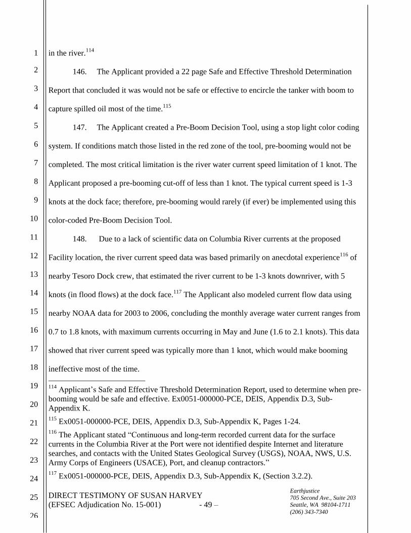
DIRECT TESTIMONY OF SUSAN HARVEY
(EFSEC Adjudication No. 15-001) - 49 –
1
2
3
4
5
6
7
8
9
10
11
12
13
14
15
16
17
18
19
20
21
22
23
24
25
26
Earthjustice
705 Second Ave., Suite 203
Seattle, WA 98104-1711
(206) 343-7340
in the river.114
146. The Applicant provided a 22 page Safe and Effective Threshold Determination
Report that concluded it was would not be safe or effective to encircle the tanker with boom to
capture spilled oil most of the time.115
147. The Applicant created a Pre-Boom Decision Tool, using a stop light color coding
system. If conditions match those listed in the red zone of the tool, pre-booming would not be
completed. The most critical limitation is the river water current speed limitation of 1 knot. The
Applicant proposed a pre-booming cut-off of less than 1 knot. The typical current speed is 1-3
knots at the dock face; therefore, pre-booming would rarely (if ever) be implemented using this
color-coded Pre-Boom Decision Tool.
148. Due to a lack of scientific data on Columbia River currents at the proposed
Facility location, the river current speed data was based primarily on anecdotal experience116
of
nearby Tesoro Dock crew, that estimated the river current to be 1-3 knots downriver, with 5
knots (in flood flows) at the dock face.117
The Applicant also modeled current flow data using
nearby NOAA data for 2003 to 2006, concluding the monthly average water current ranges from
0.7 to 1.8 knots, with maximum currents occurring in May and June (1.6 to 2.1 knots). This data
showed that river current speed was typically more than 1 knot, which would make booming
ineffective most of the time.
114
Applicant’s Safe and Effective Threshold Determination Report, used to determine when pre-
booming would be safe and effective. Ex0051-000000-PCE, DEIS, Appendix D.3, Sub-
Appendix K.
115 Ex0051-000000-PCE, DEIS, Appendix D.3, Sub-Appendix K, Pages 1-24.
116 The Applicant stated “Continuous and long-term recorded current data for the surface
currents in the Columbia River at the Port were not identified despite Internet and literature
searches, and contacts with the United States Geological Survey (USGS), NOAA, NWS, U.S.
Army Corps of Engineers (USACE), Port, and cleanup contractors.”
117 Ex0051-000000-PCE, DEIS, Appendix D.3, Sub-Appendix K, (Section 3.2.2).

DIRECT TESTIMONY OF SUSAN HARVEY
(EFSEC Adjudication No. 15-001) - 50 –
1
2
3
4
5
6
7
8
9
10
11
12
13
14
15
16
17
18
19
20
21
22
23
24
25
26
Earthjustice
705 Second Ave., Suite 203
Seattle, WA 98104-1711
(206) 343-7340
149. Fence booms are less effective in rough water, because strong currents, waves and
wind can cause the boom to twist.118
If the fence boom twists, spilled oil would by-pass the
boom at the twist location.
150. Floating containment boom will become ineffective in strong river currents.
Current speeds over 1 knot perpendicular to the long axis of the boom will result in oil slipping
under the boom skirt. Boom would be more effective in containing oil where it is aligned parallel
to the current direction; however, this is not possible for all the boom required to encircle a
tanker (a portion of the boom would need to be perpendicular to the current direction and will be
the weak spot where oil containment will be least effective). Waves of 1.5 -2.0 feet high will
likely cause oil to splash over the boom.119
151. If it is unsafe or ineffective to pre-boom, Washington State provides an alternative
option that requires boom and response equipment to be on hand, and ready to deploy in the case
of a spill.120
However, this option guarantees spilled oil will enter the river and quickly travel
down river at speeds and conditions where booming has already proven ineffective.
152. If the Applicant is loading at 32,000 barrels per hour (22,400 gallons per minute),
and the berth operator responds very quickly (one minute) to manually stop the transfer by
pressing an emergency shutdown system button, and the proposed emergency shutdown system
take at least 30 seconds to stop a transfer,121
over 33,000 gallons of oil will be spilled into the
Columbia River in that 1.5-minute period. A slower human reaction time, will increase the
118
Ex0051-000000-PCE, DEIS, Appendix D.3, Sub-Appendix K, (Section 4.3).
119 Ex0051-000000-PCE, DEIS, Appendix D.3, Sub-Appendix K, (Section 4.3).
120 WAC 173-180-221, Rate A pre-booming requirements and Rate A Alternative measures
requirements.
121 Ex0003-000000-PCE, Tesoro Savage Vancouver Energy Distribution Terminal, Application
NO. 2013-01 Supplement, February 2014, Page 2-142.

DIRECT TESTIMONY OF SUSAN HARVEY
(EFSEC Adjudication No. 15-001) - 51 –
1
2
3
4
5
6
7
8
9
10
11
12
13
14
15
16
17
18
19
20
21
22
23
24
25
26
Earthjustice
705 Second Ave., Suite 203
Seattle, WA 98104-1711
(206) 343-7340
amount of spilled oil well beyond 33,000 gallons. If isolation device fails, the spill volume will
increase proportionate to the time delay to manually isolate the leak.
153. Review of the 2013 application, raised concern about the Applicant’s inability to
boom in strong currents and poor weather conditions. In 2014, the Applicant responded by
abandoning its 2013 plan to encircle a tanker with boom, and proposed to only place boom in a
semi-circle, around the downstream portion of the tanker. No boom would be placed on the
upstream side of the tanker.122
The Applicant’s plan includes connections for an oil skimmer to
be placed in the boom to collect oil if a spill occurs; however, the skimmer would be stored on
the dock and there would be delay in getting it deployed. If a spill occurred, most the spilled oil
would swiftly travel down river while the facility deploys the skimming system, and responders
will have to chase the slick and attempt to get ahead of it.
154. The Applicant’s new, partial pre-boom configuration still suffers from the likely-
hood of oil escaping under the floating book when currents commonly exceed 1 knot, or oil
splashing over the boom when the waves exceed 1.5-2.0 feet. For example, wave heights of 2-
2.5’ may be routinely exceeded from bow waves and wakes from large tankers passing by or
during storms.123
Ex5514-000001-CRK, a page from the February 2014 Application, shows how
close the shipping lane would be to any boom installed.
155. It is important to note, that this new, partial pre-boom configuration would only
be installed if currents are less than 1.5 knots, meaning that for a significant portion of the time
there would be no boom in place at all. When no boom is in place spilled oil would travel down
122
Ex0003-000000-PCE, Tesoro Savage Vancouver Energy Distribution Terminal, Application
NO. 2013-01 Supplement, February 2014, Page 2-111 and Figure 2.10-1i. Ex5514-000001-CRK,
Preliminary Pre-Booming Diagram, Tesoro Savage Vancouver Energy Distribution Terminal,
Application NO. 2013-01 Supplement, February 2014, Page 2-154.
123 Ex0051-000000-PCE, DEIS, Appendix D.3, Sub-Appendix K, Page 4.

DIRECT TESTIMONY OF SUSAN HARVEY
(EFSEC Adjudication No. 15-001) - 52 –
1
2
3
4
5
6
7
8
9
10
11
12
13
14
15
16
17
18
19
20
21
22
23
24
25
26
Earthjustice
705 Second Ave., Suite 203
Seattle, WA 98104-1711
(206) 343-7340
the river at speeds of more than 1.5 knots and would be very difficult to recover.
156. Additionally, the Washington State Department of Ecology’s October 2014
Marine & Rail Oil Transportation Study Preliminary Findings Report states:
“Pre-booming” tank tankers during transfer operations at refineries and
terminal may not be possible with cargoes of highly volatile Bakken crude for
safety reasons; this may increase the spread of oil in the event of a spill.124
157. The Council’s DEIS recommends more work be completed to improve the pre-
booming requirement, including a requirement for the Applicant to retain a licensed engineer to
further study the issue.125
158. While the pre-booming study recommended by the DEIS will be helpful to better
understand the amount of time when pre-booming is not possible, the study request did not direct
the Applicant to include risk reduction alternatives such as limiting loading to periods of time
when the tanker can be pre-boomed or an evaluation of alternative terminal locations where
tanker pre-booming will be effective during most of the year.
159. Simply put, if it isn’t safe or effective to boom a tanker docked at the berth to load
oil, then the tanker should not be loaded with crude oil. If environmental conditions on the
Columbia River are ineffective for booming the tanker during loading, oil spill response
booming will be equally ineffective.
124
Ex0064-000570-PCE, Washington State Department of Ecology, Washington State Marine &
Rail Oil Transportation Study Preliminary Findings & Recommendations, Publication Number:
14-08-013, October 1, 2014, Page 55.
125 Ex0051-000000-PCE, DEIS, Executive Summary, Page ES-17.

DIRECT TESTIMONY OF SUSAN HARVEY
(EFSEC Adjudication No. 15-001) - 53 –
1
2
3
4
5
6
7
8
9
10
11
12
13
14
15
16
17
18
19
20
21
22
23
24
25
26
Earthjustice
705 Second Ave., Suite 203
Seattle, WA 98104-1711
(206) 343-7340
I declare under penalty of perjury that the foregoing is true and correct to the best of my
knowledge.
Executed this 10th day of May, 2016, at Eagle River, Alaska.
__________________________________
SUSAN L. HARVEY