
Beeston Town Centre - Broxtoweplanning.broxtowe.gov.uk/(S(5j10qeqkrkhp5y554cxf1uqq... ·...
40
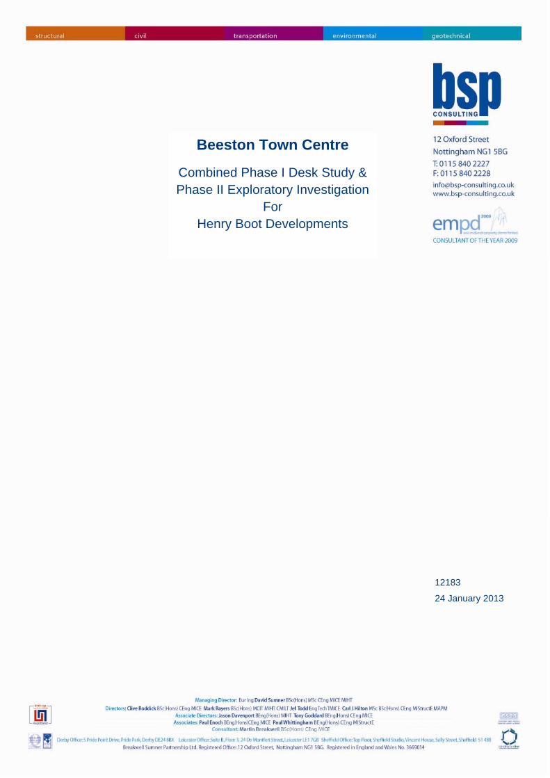
Beeston Town Centre Combined Phase I Desk Study & Phase II Exploratory Investigation For Henry Boot Developments 12183 24 January 2013
Transcript of Beeston Town Centre - Broxtoweplanning.broxtowe.gov.uk/(S(5j10qeqkrkhp5y554cxf1uqq... ·...
Beeston Town Centre
Combined Phase I Desk Study & Phase II Exploratory Investigation
For Henry Boot Developments
12183
24 January 2013
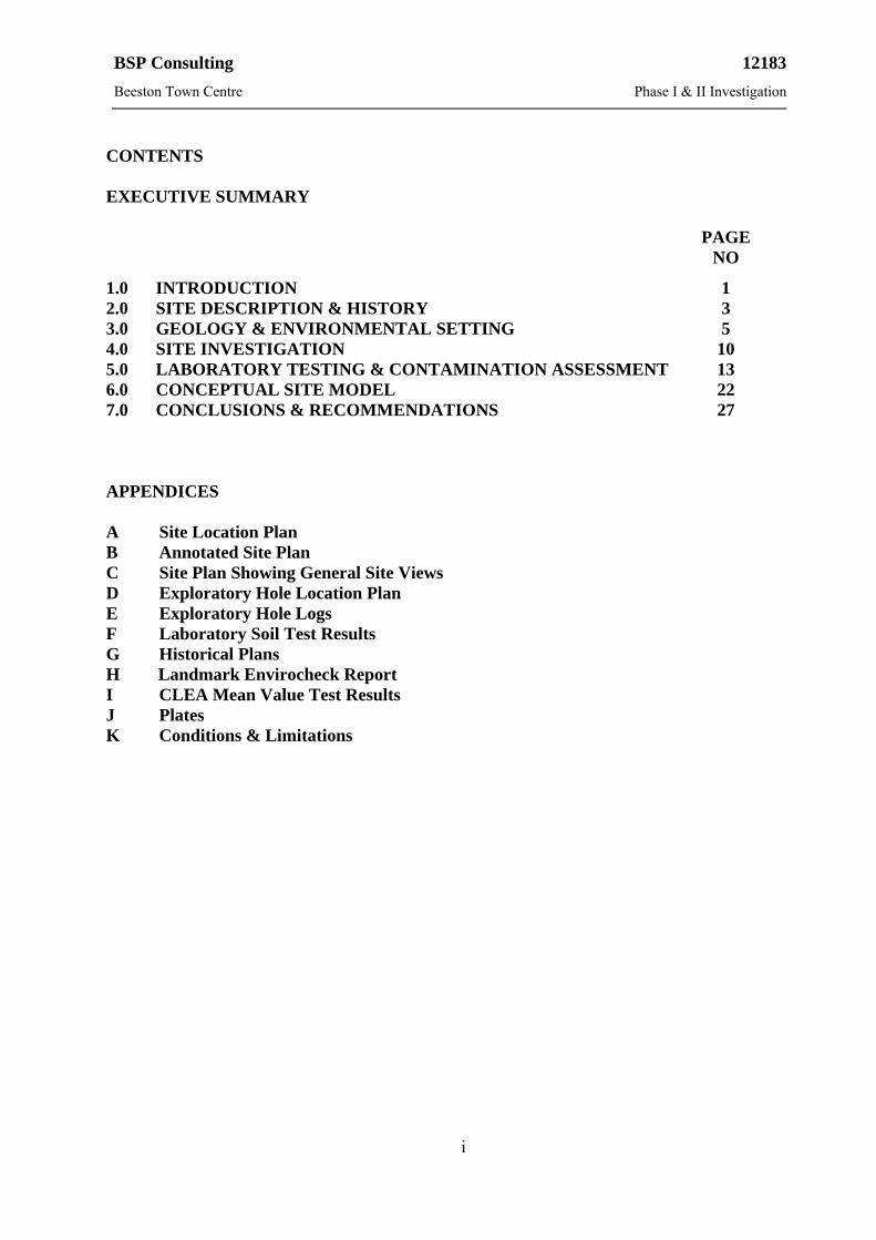
BSP Consulting 12183
Beeston Town Centre Phase I & II Investigation
i
CONTENTS EXECUTIVE SUMMARY PAGE
NO
1.0 INTRODUCTION 1 2.0 SITE DESCRIPTION & HISTORY 3 3.0 GEOLOGY & ENVIRONMENTAL SETTING 5 4.0 SITE INVESTIGATION 10 5.0 LABORATORY TESTING & CONTAMINATION ASSESSMENT 13 6.0 CONCEPTUAL SITE MODEL 22 7.0 CONCLUSIONS & RECOMMENDATIONS 27 APPENDICES A Site Location Plan B Annotated Site Plan C Site Plan Showing General Site Views D Exploratory Hole Location Plan E Exploratory Hole Logs F Laboratory Soil Test Results G Historical Plans H Landmark Envirocheck Report I CLEA Mean Value Test Results J Plates K Conditions & Limitations
BSP Consulting 12183
Beeston Town Centre Phase I & II Investigation
ii
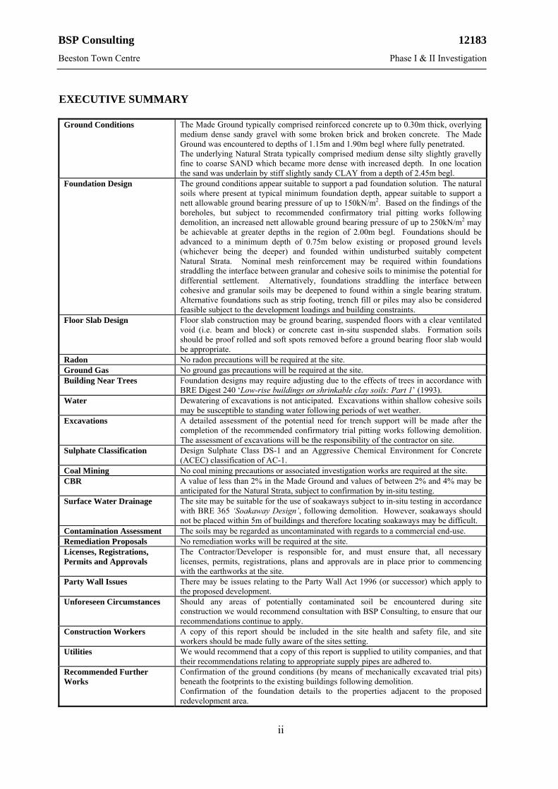
EXECUTIVE SUMMARY
Ground Conditions The Made Ground typically comprised reinforced concrete up to 0.30m thick, overlying
medium dense sandy gravel with some broken brick and broken concrete. The Made Ground was encountered to depths of 1.15m and 1.90m begl where fully penetrated. The underlying Natural Strata typically comprised medium dense silty slightly gravelly fine to coarse SAND which became more dense with increased depth. In one location the sand was underlain by stiff slightly sandy CLAY from a depth of 2.45m begl.
Foundation Design The ground conditions appear suitable to support a pad foundation solution. The natural soils where present at typical minimum foundation depth, appear suitable to support a nett allowable ground bearing pressure of up to 150kN/m2. Based on the findings of the boreholes, but subject to recommended confirmatory trial pitting works following demolition, an increased nett allowable ground bearing pressure of up to 250kN/m2 may be achievable at greater depths in the region of 2.00m begl. Foundations should be advanced to a minimum depth of 0.75m below existing or proposed ground levels (whichever being the deeper) and founded within undisturbed suitably competent Natural Strata. Nominal mesh reinforcement may be required within foundations straddling the interface between granular and cohesive soils to minimise the potential for differential settlement. Alternatively, foundations straddling the interface between cohesive and granular soils may be deepened to found within a single bearing stratum. Alternative foundations such as strip footing, trench fill or piles may also be considered feasible subject to the development loadings and building constraints.
Floor Slab Design Floor slab construction may be ground bearing, suspended floors with a clear ventilated void (i.e. beam and block) or concrete cast in-situ suspended slabs. Formation soils should be proof rolled and soft spots removed before a ground bearing floor slab would be appropriate.
Radon No radon precautions will be required at the site. Ground Gas No ground gas precautions will be required at the site. Building Near Trees Foundation designs may require adjusting due to the effects of trees in accordance with
BRE Digest 240 ‘Low-rise buildings on shrinkable clay soils: Part 1’ (1993). Water Dewatering of excavations is not anticipated. Excavations within shallow cohesive soils
may be susceptible to standing water following periods of wet weather. Excavations A detailed assessment of the potential need for trench support will be made after the
completion of the recommended confirmatory trial pitting works following demolition. The assessment of excavations will be the responsibility of the contractor on site.
Sulphate Classification Design Sulphate Class DS-1 and an Aggressive Chemical Environment for Concrete (ACEC) classification of AC-1.
Coal Mining No coal mining precautions or associated investigation works are required at the site. CBR A value of less than 2% in the Made Ground and values of between 2% and 4% may be
anticipated for the Natural Strata, subject to confirmation by in-situ testing. Surface Water Drainage The site may be suitable for the use of soakaways subject to in-situ testing in accordance
with BRE 365 ‘Soakaway Design’, following demolition. However, soakaways should not be placed within 5m of buildings and therefore locating soakaways may be difficult.
Contamination Assessment The soils may be regarded as uncontaminated with regards to a commercial end-use. Remediation Proposals No remediation works will be required at the site. Licenses, Registrations, Permits and Approvals
The Contractor/Developer is responsible for, and must ensure that, all necessary licenses, permits, registrations, plans and approvals are in place prior to commencing with the earthworks at the site.
Party Wall Issues There may be issues relating to the Party Wall Act 1996 (or successor) which apply to the proposed development.
Unforeseen Circumstances Should any areas of potentially contaminated soil be encountered during site construction we would recommend consultation with BSP Consulting, to ensure that our recommendations continue to apply.
Construction Workers A copy of this report should be included in the site health and safety file, and site workers should be made fully aware of the sites setting.
Utilities We would recommend that a copy of this report is supplied to utility companies, and that their recommendations relating to appropriate supply pipes are adhered to.
Recommended Further Works
Confirmation of the ground conditions (by means of mechanically excavated trial pits) beneath the footprints to the existing buildings following demolition. Confirmation of the foundation details to the properties adjacent to the proposed redevelopment area.
BSP Consulting 12183
Beeston Town Centre Phase I & II Investigation
1
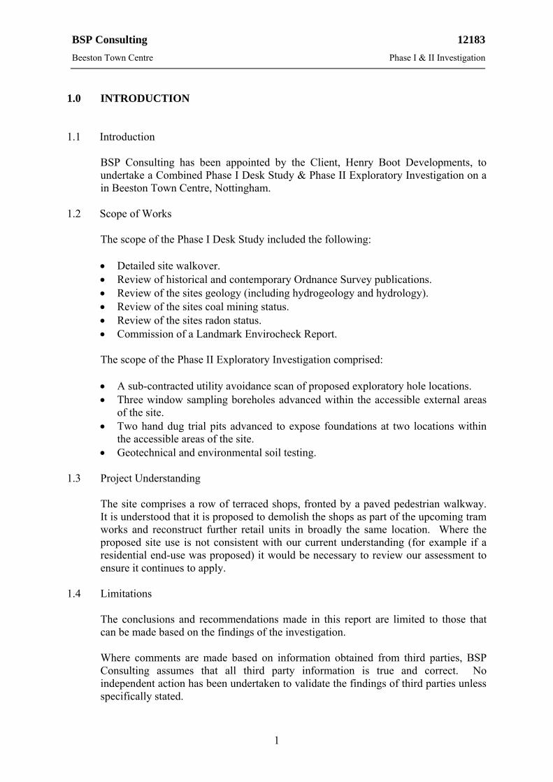
1.0 INTRODUCTION 1.1 Introduction
BSP Consulting has been appointed by the Client, Henry Boot Developments, to undertake a Combined Phase I Desk Study & Phase II Exploratory Investigation on a in Beeston Town Centre, Nottingham.
1.2 Scope of Works
The scope of the Phase I Desk Study included the following:
Detailed site walkover. Review of historical and contemporary Ordnance Survey publications. Review of the sites geology (including hydrogeology and hydrology). Review of the sites coal mining status. Review of the sites radon status. Commission of a Landmark Envirocheck Report.
The scope of the Phase II Exploratory Investigation comprised:
A sub-contracted utility avoidance scan of proposed exploratory hole locations. Three window sampling boreholes advanced within the accessible external areas
of the site. Two hand dug trial pits advanced to expose foundations at two locations within
the accessible areas of the site. Geotechnical and environmental soil testing.
1.3 Project Understanding
The site comprises a row of terraced shops, fronted by a paved pedestrian walkway. It is understood that it is proposed to demolish the shops as part of the upcoming tram works and reconstruct further retail units in broadly the same location. Where the proposed site use is not consistent with our current understanding (for example if a residential end-use was proposed) it would be necessary to review our assessment to ensure it continues to apply.
1.4 Limitations
The conclusions and recommendations made in this report are limited to those that can be made based on the findings of the investigation.
Where comments are made based on information obtained from third parties, BSP Consulting assumes that all third party information is true and correct. No independent action has been undertaken to validate the findings of third parties unless specifically stated.
BSP Consulting 12183
Beeston Town Centre Phase I & II Investigation
2
This report has been prepared in accordance with our understanding of current best practice. However, new information or legislation, or changes to best practice may necessitate revision of the report after the date of its issue.
We would note that the scope of laboratory testing and our assessment of the chemical soil test results have been primarily focussed on potential risks to human health. Our scope of chemical testing and assessment has not been specifically designed to fulfil any landfill or waste disposal company’s requirements to suitably characterise any waste soil arising during future redevelopment of the site, or accurately determine disposal costs for any waste soil, although it will assist in such an assessment.
BSP Consulting has prepared this report for the sole use and reliance of the Client, Henry Boot Developments, in accordance with our standard Conditions & Limitations (included in Appendix K).
This report may not be used or relied upon by any unauthorised third party without the explicit written agreement of BSP Consulting.
1.5 Confidentiality
The human health risk assessment undertaken herein remains the intellectual property and trade secret of BSP Consulting. The information contained within this report must not be disclosed or divulged to any commercial Consultant or other third party without the prior written agreement of BSP Consulting.

BSP Consulting 12183
Beeston Town Centre Phase I & II Investigation
3
2.0 SITE DESCRIPTION & HISTORY 2.1 Site Description
The site is situated in Beeston Town Centre, Nottingham, to the immediate south of the pedestrianised area known locally as ‘The Square’. The site may be located centred around approximate Ordnance Survey National Grid Reference 452830E 336810N, as shown on the Site Location Plan (Figure No. 12183/01) included in Appendix A. The site covers a total area of approximately 0.99Ha, although this report concentrates on the smaller retail area, proposed for redevelopment in the centre of the site.
At the time of our walkover (November 2012) the site (i.e. the redevelopment area) comprised a two-storey row of shops, fronted to the northwest and southwest by a paved pedestrian walkway. Some of the shops were noted as empty whilst others (including a charity shop, a card shop and an electrical retailer) continued to trade. Access was restricted to certain areas within the shops during the site walkover and subsequent intrusive works.
The shops adjoined further retail premises to the northeast (‘Nationwide Building Society’) and southeast (‘B&M Bargains’). An area of concrete hardstanding was present to the east of the southernmost units, used to facilitate deliveries and provide limited car-parking.
The site was sensibly level and devoid of any significant vegetation. The site is located within a commercial setting.
The Annotated Site Plan in Appendix B of this report (Figure No. 12183/02) shows the main features of the site and immediate surrounding area. General views of the site are included on the plan in Appendix C (Figure No. 12183/03).
2.2 Site History
Available historical and contemporary Ordnance Survey publications (detailed in Appendix G) were reviewed to obtain historical information for the site.
We would note that the historical plans relate to the wider site area, of which the current redevelopment site is situated in the central part. Our review of the historical maps relates to the wider site area.
It should be noted that the site boundary marked on the historical sheets within the Envirocheck Report appears to ‘shift’ on several of the maps due to scaling inaccuracies between maps of differing dates. This is a function of Envirocheck transposition algorithms.
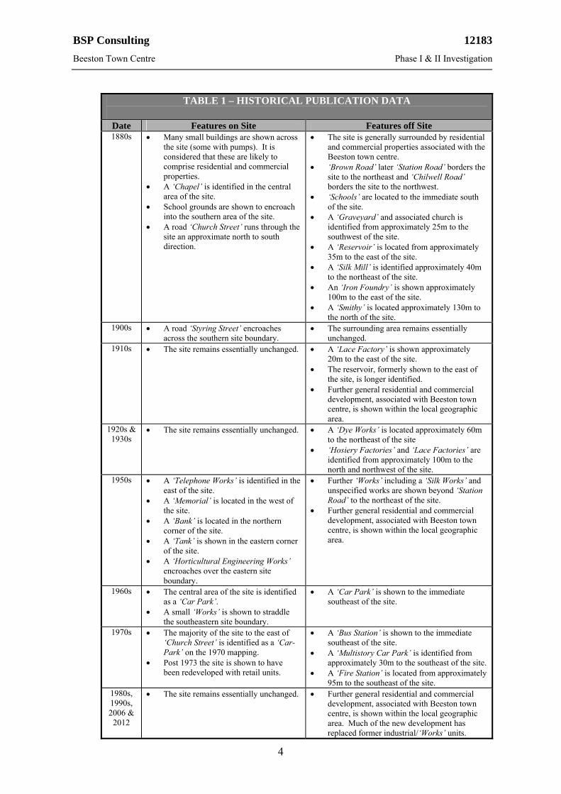
The key findings of the historical search are summarised in Table 1.
BSP Consulting 12183
Beeston Town Centre Phase I & II Investigation
4
TABLE 1 – HISTORICAL PUBLICATION DATA
Date Features on Site Features off Site 1880s Many small buildings are shown across
the site (some with pumps). It is considered that these are likely to comprise residential and commercial properties.
A ‘Chapel’ is identified in the central area of the site.
School grounds are shown to encroach into the southern area of the site.
A road ‘Church Street’ runs through the site an approximate north to south direction.
The site is generally surrounded by residential and commercial properties associated with the Beeston town centre.
‘Brown Road’ later ‘Station Road’ borders the site to the northeast and ‘Chilwell Road’ borders the site to the northwest.
‘Schools’ are located to the immediate south of the site.
A ‘Graveyard’ and associated church is identified from approximately 25m to the southwest of the site.
A ‘Reservoir’ is located from approximately 35m to the east of the site.
A ‘Silk Mill’ is identified approximately 40m to the northeast of the site.
An ‘Iron Foundry’ is shown approximately 100m to the east of the site.
A ‘Smithy’ is located approximately 130m to the north of the site.
1900s A road ‘Styring Street’ encroaches across the southern site boundary.
The surrounding area remains essentially unchanged.
1910s The site remains essentially unchanged. A ‘Lace Factory’ is shown approximately 20m to the east of the site.
The reservoir, formerly shown to the east of the site, is longer identified.
Further general residential and commercial development, associated with Beeston town centre, is shown within the local geographic area.
1920s & 1930s
The site remains essentially unchanged. A ‘Dye Works’ is located approximately 60m to the northeast of the site
‘Hosiery Factories’ and ‘Lace Factories’ are identified from approximately 100m to the north and northwest of the site.
1950s A ‘Telephone Works’ is identified in the east of the site.
A ‘Memorial’ is located in the west of the site.
A ‘Bank’ is located in the northern corner of the site.
A ‘Tank’ is shown in the eastern corner of the site.
A ‘Horticultural Engineering Works’ encroaches over the eastern site boundary.
Further ‘Works’ including a ‘Silk Works’ and unspecified works are shown beyond ‘Station Road’ to the northeast of the site.
Further general residential and commercial development, associated with Beeston town centre, is shown within the local geographic area.
1960s The central area of the site is identified as a ‘Car Park’.
A small ‘Works’ is shown to straddle the southeastern site boundary.
A ‘Car Park’ is shown to the immediate southeast of the site.
1970s The majority of the site to the east of ‘Church Street’ is identified as a ‘Car-Park’ on the 1970 mapping.
Post 1973 the site is shown to have been redeveloped with retail units.
A ‘Bus Station’ is shown to the immediate southeast of the site.
A ‘Multistory Car Park’ is identified from approximately 30m to the southeast of the site.
A ‘Fire Station’ is located from approximately 95m to the southeast of the site.
1980s, 1990s, 2006 &
2012
The site remains essentially unchanged. Further general residential and commercial development, associated with Beeston town centre, is shown within the local geographic area. Much of the new development has replaced former industrial/‘Works’ units.
BSP Consulting 12183
Beeston Town Centre Phase I & II Investigation
5
3.0 GEOLOGY & ENVIRONMENTAL SETTING 3.1 Geological References
The following geological publications were referred to:
BGS 1:50000 Series Sheet 125 ‘Derby’ (1972). BGS 1:10560 Series Sheet SK53 NW (1967). BGS Memoir ‘Geology of the Nottingham District’ (2009). BGS publication ‘The Pennines & Adjacent Areas’ Fourth Edition (2002). BGS publication ‘Technical Report WA/90/1 Nottingham: A Geological
Background for Planning & Development’ (1990). The Coal Authority and The Law Society publication ‘Coal Mining and Brine
Subsidence Claim Searches – Directory and Guidance’ Sixth Edition (2006). 3.2 Geology
The geological publications indicate that the site is underlain by First Terrace deposits of Recent and Pleistocene age. The First Terrace deposits in the Beeston area are described as in the BGS publications as ‘sands and gravels’.
The drift deposits are indicated to be underlain in the northern half of the site by Bunter Pebble Beds (part of the Nottingham Castle Sandstone Formation in current nomenclature), of Permo-Triassic age. The drift deposits are indicated to be underlain in the southern half of the site by Keuper Marl (part of the Mercia Mudstone Group in current nomenclature), also of Permo-Triassic age.
The Nottingham Castle Sandstone Formation is described in the BGS publications as ‘yellowish grey pebbly sandstones’. The Mercia Mudstone is described in the BGS publications as ‘grey red and brown mudstones and siltstones with skerry bands….which may weather to clay near surface’.
3.3 Faults
A surface fault is indicated on the geological publications to run through the centre of the site trending in an approximate northwesterly to southeasterly direction. The fault is downthrown to the southwest.
3.4 Man-Made Deposits
The majority of the geological publications do not show the presence of any man-made deposits (i.e. Made Ground, Worked Ground or Landscaped Ground) beneath, or within potential influencing distance of the site (i.e. <250m). We would note however that ‘Map 4C: Distribution of Made and Disturbed Ground’, from within the Technical Report referenced in Section 3.1, shows the presence of undifferentiated Made Ground (generally 1 to 2m in thickness) both beneath the site and in the local geographic area.
BSP Consulting 12183
Beeston Town Centre Phase I & II Investigation
6
The Made Ground is considered to be a derivative of the historical urban development within the Beeston town centre, rather than the product of more onerous cut-and-fill activities.
The wider surrounding area is shown as Landscaped Ground which comprises ‘areas where the original land surface has been extensively remodelled by earthmoving and tipping, but where it is impractical or impossible to delineate individual deposits of made-up ground or backfill’.
3.5 Landmark Envirocheck Report
A Landmark Envirocheck Report was commissioned to assist in ascertaining the environmental setting of the site. The full Envirocheck Report is presented in Appendix H and has revealed the following relevant information. We would note that the Envirocheck Report relates to the entire site area of which the current redevelopment site is situated in the central part. (Details are only listed where they are within 250m of the site).
3.5.1 Agency & Hydrological
Aquifer Status & Groundwater Vulnerability
In April 2010 the Environment Agency reclassified aquifers in line with the Water Framework Directive. On this basis, the superficial deposits at the site (i.e. First Terrace deposits) are now classified as a Secondary A Aquifer and the underlying bedrock (i.e. Nottingham Castle Sandstone Formation in the northern half of the site and Mercia Mudstone in the southern half of the site) are classified as a Principal and Secondary B Aquifers respectively.
The Environment Agency describe a Secondary A Aquifer as ‘permeable layers capable of supporting water supplies at a local rather than strategic scale, and in some cases forming an important source of base flow to rivers. These are generally aquifers formerly classified as minor aquifers’.
The Environment Agency describe a Principal Aquifer as ‘layers of rock or drift deposits that have high intergranular and/or fracture permeability - meaning they usually provide a high level of water storage. They may support water supply and/or river base flow on a strategic scale. In most cases, principal aquifers are aquifers previously designated as major aquifers’.
The Environment Agency describe a Secondary B Aquifer as ‘predominantly lower permeability layers which may store and yield limited amounts of groundwater due to localised features such as fissures, thin permeable horizons and weathering. These are generally the water-bearing parts of the former non-aquifers’.
Discharge Consents
Two discharge consents have been issued within 250m of the site. Both relate to the discharge of storm sewage overflow to a stream/river 163m to the south of the site. The permits are dated 1974 (revoked) and 2009 (revocation date not supplied).
BSP Consulting 12183
Beeston Town Centre Phase I & II Investigation
7
Local Authority Pollution Prevention and Controls
Four permits have been issued within 250m of the site. The closest relates to a dry cleaning business 27m to the north of the site (status: permitted). The other three permits relate to waste oil burners 240m to the southeast of the site (application refused or cancelled), printing of flexible packaging 249m to the southeast of the site (authorisation revoked) and a petrol filling station (status: authorised) 242m to the north of the site.
Local Authority Pollution Prevention and Control Enforcements
One enforcement notice has been issued within 250m of the site. This relates to an air pollution control enforcement notice 249m to the southeast of the site (on Nether Street). The notice was issued in 2007.
Pollution Incidents to Controlled Waters
One pollution incident to controlled waters has been recorded within 250m of the site. This relates to the deliberate disposal of vegetable oil to a drain from a food industry property (restaurant) 133m to the north of the site. The incident took place in 1996 and is described as a Category 3 – Minor Incident.
Source Protection Zone Status
The site is shown to lie within a Source Protection Zone (SPZ) as designated by the Environment Agency. An SPZ relates to the protection of groundwater used for public drinking water supply. The SPZ is described as ‘Zone III (Total Catchment): The total area needed to support the discharge from the protected groundwater source’.
Flood Risk Status
The site is not shown to lie in area identified to be at risk from flooding. The land from 156m to the southeast of the site is designated as being at risk of extreme flooding from rivers or sea without defences.
Surface Water
No surface water features were identified at the site. No significant surface water features have been identified in the Landmark Envirocheck Report within 250m of the site.
3.5.2 Waste
There are no recorded landfill sites or waste transfer facilities indicated within potential influencing distance of the site (i.e. <250m).
BSP Consulting 12183
Beeston Town Centre Phase I & II Investigation
8
3.5.3 Hazardous Substances
There are no sites associated with hazardous substances (e.g. explosives) identified within 250m of the site.
3.5.4 Geological & Radon
No potentially significant onerous geological issues have been identified within the Landmark Envirocheck Report, which relate to the site.
The site is described as being ‘In an area that might not be affected by coal mining’.
The site does not lie within an area identified by Landmark as requiring radon protective measures.
3.5.5 Industrial Land Use
Three Contemporary Trade Directory Entries are identified on the site. The one active entry relates to ‘H Dainty & Co’, an electrical goods servicing and repairs business close to the northern boundary. The two inactive entries relate to a duty free perfume shop and a business which formerly manufactured and supplied disability equipment. Eighteen Contemporary Trade Directory Entries are recorded within 250m of the site. Of these, five are currently recorded as active. The off-site entries include businesses relating to garage services, photographic services and a blacksmiths.
There are three fuel station entries identified within 250m of the site. The former fuel stations 174m to the northwest and 182m to the south are recorded as obsolete. There is one open fuel station recorded at the Sainsbury’s supermarket 242m to the north of the site.
3.5.6 Sensitive Land Use
The site and immediate surrounding area are identified as being within a Nitrate Vulnerable Zone. In our experience the majority of this area of the country is defined as a Nitrate Vulnerable Zone and this classification is not considered to present a potential risk to the site.
3.6 Land Use Assessment
As part of the land use assessment, reference has been made to the ‘Desk Reference Guide to potentially Contaminative Land Uses’ produced by Mr P Syms and published jointly by the ISVA (The professional Society for Valuers and Auctioneers) in association with The Royal Institution of Chartered Surveyors (RICS) and the Chartered Institute of Environmental Health (CIEH).
Reference has also been made to the DEFRA publication CLR8 ‘Potential contaminants for the assessment of land’ (March 2002).
BSP Consulting 12183
Beeston Town Centre Phase I & II Investigation
9
3.6.1 On Site Assessment
Based on the Syms and CLR 8 documents, the sites current and previous land uses do not fall within any of the risk based classifications identified within these publications.
Based on the information obtained from the desk study, our walkover of the site and our experience of similar sites, potential contamination that may be present could include:
Metals associated with Made Ground beneath the site. Natural Metal Enrichment (NME) in Natural Strata. Polyaromatic Hydrocarbons (PAH’s) derived from any ashy inclusions in the near
surface soils. 3.6.2 Off Site Assessment
Based on the information obtained from the desk study, no potential significant off-site contamination has been identified that may be present within potential influencing distance of the site (i.e. <250m).
BSP Consulting 12183
Beeston Town Centre Phase I & II Investigation
10
4.0 SITE INVESTIGATION 4.1 Introduction
Sub-Surface Utility Scan
Prior to the commencement of our intrusive works at the site a sub-contracted sub-surface utility scan was undertaken to attempt to avoid buried services during the intrusive works. Based on the results of the service scan and taking account of the requirement to avoid buried services, the exploratory holes were positioned to maximise the amount of information obtained at the site.
Window Sample Boreholes
Three window sample boreholes (WS1 to WS3) were advanced at the site on 19th December 2012, in accessible external areas of the site, to depths of between 0.70m and 3.00m below existing ground level (begl). Access was not possible with the borehole rig, to the internal areas of the vacant units, due to door width and height restrictions.
Hand Dug Trial Pits
Two hand dug trial pits (HDTP1 and HDTP2) were excavated at the site on 19th December 2012 in an attempt to expose the existing foundations in two locations. HDTP1 was terminated at 1.35m begl (i.e. the extent of the hand held excavating equipment). HDTP2 was excavated within the internal area of Unit 11. The concrete slab could not be fully penetrated in HDTP2 using the available pneumatic hand held drilling equipment.
Exploratory Hole Locations and Logs
The approximate locations of the exploratory holes are indicated on the plan presented in Appendix D of this report (Figure No. 12183/04). The exploratory hole logs (including details of the hand dug trial pits; Figure No. 12183/05 and Figure No. 12183/06) are presented in Appendix E of this report.
4.2 Ground Conditions (Window Sample Boreholes)
Made Ground
The Made Ground typically comprised reinforced concrete up to 0.30m thick, overlying medium dense sandy fine to coarse gravel with some broken brick and broken concrete. The Made Ground was encountered to depths of 1.15m and 1.90m begl where fully penetrated. In one location (WS3) the borehole was terminated at 0.70m begl due to the presence of concrete (possible buried slab).
BSP Consulting 12183
Beeston Town Centre Phase I & II Investigation
11
Natural Strata
The underlying Natural Strata typically comprised medium dense silty slightly gravelly fine to coarse SAND which became more dense with increased depth. In WS1, the sand was underlain by stiff slightly sandy CLAY from a depth of 2.45m begl.
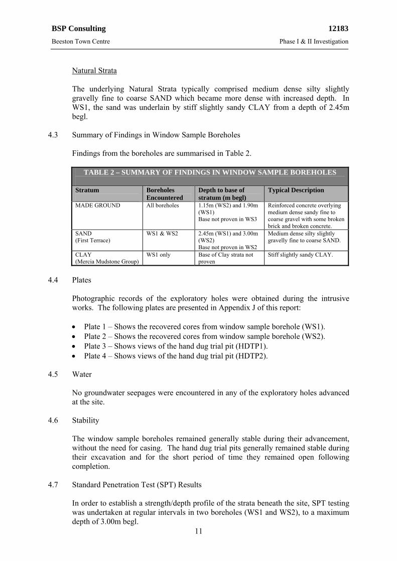
4.3 Summary of Findings in Window Sample Boreholes
Findings from the boreholes are summarised in Table 2.
TABLE 2 – SUMMARY OF FINDINGS IN WINDOW SAMPLE BOREHOLES Stratum
Boreholes Encountered
Depth to base of stratum (m begl)
Typical Description
MADE GROUND All boreholes 1.15m (WS2) and 1.90m (WS1) Base not proven in WS3
Reinforced concrete overlying medium dense sandy fine to coarse gravel with some broken brick and broken concrete.
SAND (First Terrace)
WS1 & WS2 2.45m (WS1) and 3.00m (WS2) Base not proven in WS2
Medium dense silty slightly gravelly fine to coarse SAND.
CLAY (Mercia Mudstone Group)
WS1 only Base of Clay strata not proven
Stiff slightly sandy CLAY.
4.4 Plates
Photographic records of the exploratory holes were obtained during the intrusive works. The following plates are presented in Appendix J of this report:
Plate 1 – Shows the recovered cores from window sample borehole (WS1). Plate 2 – Shows the recovered cores from window sample borehole (WS2). Plate 3 – Shows views of the hand dug trial pit (HDTP1). Plate 4 – Shows views of the hand dug trial pit (HDTP2).
4.5 Water
No groundwater seepages were encountered in any of the exploratory holes advanced at the site.
4.6 Stability
The window sample boreholes remained generally stable during their advancement, without the need for casing. The hand dug trial pits generally remained stable during their excavation and for the short period of time they remained open following completion.
4.7 Standard Penetration Test (SPT) Results
In order to establish a strength/depth profile of the strata beneath the site, SPT testing was undertaken at regular intervals in two boreholes (WS1 and WS2), to a maximum depth of 3.00m begl.

BSP Consulting 12183
Beeston Town Centre Phase I & II Investigation
12
The uncorrected SPT ‘N’ values within the Made Ground at a depth of 1.00m begl were recorded as 10 and 12. The uncorrected SPT ‘N’ values within the Natural Strata at a depth of 2.00m begl were recorded as 20 and refusal (i.e. an SPT result equal to or greater than 50).
The uncorrected SPT ‘N’ value within the Natural Strata at a depth of 3.00m begl was also recorded as refusal.
BSP Consulting 12183
Beeston Town Centre Phase I & II Investigation
13
5.0 LABORATORY TESTING & CONTAMINATION ASSESSMENT 5.1 Introduction
The following environmental soil testing was carried out on visually representative samples recovered from the exploratory holes based on our land use assessment of the site.
8 No. Standard chemical contamination suites. 8 No. Total Organic Carbon tests.
The following geotechnical soil testing was carried out on visually representative samples recovered from the exploratory holes.
1 No. Plasticity Index (PI) tests. 2 No. Particle Size Distribution (PSD) tests. 3 No. Water soluble sulphate tests. 8 No. pH tests.
The environmental and geotechnical laboratory soil test results are presented in Appendix F of this report.
5.2 Geotechnical Soil Test Results
Water Soluble Sulphate
Water soluble sulphate testing was undertaken on selected samples of the Made Ground (2 No.) and Natural Strata (1 No.) and revealed concentrations of between <0.01g/l and 0.06g/l. The pH values of the samples analysed ranged between 7.35 and 10.18.
In accordance with the Building Research Establishment publication Special Digest 1 ‘Concrete in Aggressive Ground’ (2005) the highest sulphate concentration should be used to indicate the Design Sulphate Class (0.06g/l SO4) together with the lowest of the pH values (7.35). Therefore, in accordance with Special Digest 1 (assuming mobile groundwater and a brownfield location) the site falls into Design Sulfate Class DS-1 and an Aggressive Chemical Environment for Concrete (ACEC) classification of AC-1.
Plasticity Index Analysis
Plasticity Index (PI) analysis was undertaken on one representative sample of the near surface visually cohesive natural deposits (i.e. Clay). In accordance with BRE Digest 240 ‘Low-rise buildings on shrinkable clay soils: Part 1’ (1993), the reported PI values may be modified based on the portion of sample retained on the 425m sieve. The results of the Plasticity Index analysis is summarised in Table 3.

BSP Consulting 12183
Beeston Town Centre Phase I & II Investigation
14
The result of the Plasticity Index analysis is summarised in Table 3.
TABLE 3 – SUMMARY OF PLASTICITY INDEX (PI) DATA
Sample Ref. Reported PI
Value (%) Portion
<425m (%) Modified PI Value (%)
Volume Change Potential
WS1 - 2.05m 18 100 18 Low
In accordance with Table 3, the sample analysed is of a low volume change potential in accordance with BRE guidance.
Particle Size Distribution Analysis
Particle Size Distribution (PSD) analysis was undertaken on two representative samples of the near surface visually cohesive granular deposits (i.e. Sand). The results confirm the tested soils to comprise silty slightly gravelly fine to coarse SAND.
5.3 Contamination Assessment Rationale
It is understood that it is proposed to redevelop the site for a commercial end-use. Therefore, the assessment of the contamination test results has been undertaken based on a commercial end-use.
5.4 Appropriate Guidance
Reference has been made to documents reflecting current best practice, including (but not limited to) the following:
Department of Environment, Food and Rural Affairs (DEFRA) and the
Environment Agency publication – ‘Contaminated Land Exposure Assessment (CLEA) model’ (March 2002).
R & D Publication SGV 10 Lead (March 2002). Environment Agency Science Report, ‘Using Soil Guideline Values’,
SC050021/SGV, March 2009. Environment Agency Science Reports Arsenic SGV (May 2009), Nickel SGV,
Mercury SGV, Selenium SGV, Benzene SGV, Toluene SGV, Ethylbenzene SGV, Xylene SGV (all March 2009), Phenol and Cadmium (June 2009), Dioxins and Furans (September 2009).
R & D Draft Technical Report P5-079/TR1 ‘Review of the Fate and Transport of Selected Contaminants in the Soil Environment’ dated 2003.
Chartered Institute of Environmental Health (CIEH) and Land Quality Management (LQM) publication ‘Generic Assessment Criteria for Human Health Risk Assessment’ 2nd Edition, July 2009, ISBN 0-9547474-7-X.
CL:AIRE/CIEH ‘Guidance on Comparing Soil Contamination Data with a Critical Concentration’ (May 2008).
Environment Agency Science Report SC050021/SR7 ‘Compilation of Data for Priority Organic Pollutants for Derivation of Soil Guideline Values’, dated November 2008, ISBN 978-84432-964-9.
BSP Consulting 12183
Beeston Town Centre Phase I & II Investigation
15
Environment Agency Science Report Final SC050021/SR2 ‘Human health
toxicological assessment of contaminants in soil’, dated January 2009, ISBN 978-84432-858-1.
Environment Agency Science Report SC050021/SR3 ‘Updated technical background to the CLEA model’, dated January 2009, ISBN 978-84432-856-7.
Environment Agency Science Report SC050021/SR4 ‘CLEA Software (Version 1.05) Handbook’, dated September 2009, ISBN 978-1-84911-105-8.
United States Environmental Protection Agency (EPA) Environmental Regulations and Technology – ‘Control of Pathogens and Vector Attraction in Sewage Sludge’ (October 1999).
CL:AIRE Report ISBN 978-1-905046-20-1 ‘The Soil Generic Assessment Criteria for Human Health Risk Assessment’ (December 2009).
5.4.1 Selection of Appropriate Tier 1 Screening Values
The assessment of contaminated land in the UK was historically undertaken with reference to ICRCL Guidance Note 59/83 together with successive versions of the CLEA model (inc. CLEA2002 (2002), CLEA UK (2005), CLEA V1.03 beta (2008), CLEA V1.04 (January 2009), CLEA V1.05 (September 2009) and CLEA V1.06 (October 2009)).
The CLEA V1.06 model is a deterministic quantitative risk assessment (QRA) model which is proposed to be used to derive revised Soil Guideline Values (SGVs) for a range of contaminants. To date, CLEA derived SGVs have been published for the following contaminants: Arsenic, Cadmium, Nickel, Mercury, Selenium, Benzene, Toluene, Ethylbenzene, Xylene and Phenol, Dioxins and Furans. SGVs are derived adopting a Sandy Loam soil with 6% Soil Organic Matter (SOM).
In accordance with general industry best practice, these published generic CLEA SGVs have been referred to in the first instance (where available) and have been adopted at Tier 1 level.
Whilst the CLEA 2002 model has been formally withdrawn, the model currently provides the only publicly available Lead model adopted as UK policy/practice, consequently, the original SGV for Lead is retained herein.
In the absence of published SGVs, BSP has adopted Generic Assessment Criteria (GAC) derived by CIEH/LQM. These are based on CLEA V1.04 final. Further reference has also been made to CL:AIRE guidance.
A quote from the CIEH’s Howard Price stated “This is a fantastic result and a great tribute to Paul and the LQM team, along with the volunteers who helped crunch the numbers. It’s a very good example of cross sector help, and frankly puts the official SGV programme to shame again. We expect that these values will quickly become the numbers of choice in both the public and private sectors. Relevant, appropriate, authoritative and scientifically-based, they can be used with confidence and employed properly, we believe they will meet an important need in the risk assessment process” (Contaminated Land Bulletin August 2009).
BSP Consulting 12183
Beeston Town Centre Phase I & II Investigation
16
Taking account of the foregoing, we consider that industry best practice is currently best represented by CIEH/LQM GAC together with new SGV and CL:AIRE guidance values and these have been adopted herein.
The level of GAC selected for organic determinants is partially dependant upon Soil Organic Matter (SOM) content, with GAC values being available at 1%, 2.5% and 6% SOM as standard.
In the following sections, all the Tier 1 assessment criteria have been collectively referred to as ‘Site Acceptance Criteria’ (SAC). The SAC adopted herein, i.e. for commercial end-use, are detailed on the CLEA Mean Value sheets presented in Appendix I.
5.4.2 Site-Specific Considerations
The following site-specific condition has been considered, at Tier 1 level, with respect to the Made Ground and Natural Strata at the site:
Soil Organic Matter (SOM) content.
The SOM content and soil type are used to provide an assessment of the applicability of the Tier 1 SAC adopted (the CLEA SGV are based on the default assumption of a UK Sandy Loam soil with 6% SOM, whilst the LQM GAC values are based upon SOM of 1%, 2.5% and 6%, as applicable).
Determinants have in the first instance, been compared to standard CLEA SGVs together with CIEH/LQM GAC (adopting a conservative SOM of 1%). Where the determinant exceeds the relevant SAC of 1% SOM, a site specific SOM may be adopted as appropriate to derive new GAC and the dataset reassessed.
5.5 Statistical Considerations
Statistical tests relating to contaminated land, typically referred to as a Mean and Maximum Value Tests, were detailed in Department for Environment, Food and Rural Affairs and The Environment Agency publication CLR 7 ‘Assessment of Risks to Human Health From Land Contamination: An Overview of the Development of Soil Guideline Values and Related Research’, dated 2002, ISBN 1-857-05732-5. This guidance was superseded by publication of CL:AIRE/CIEH ‘Guidance on Comparing Soil Contamination Data with a Critical Concentration’ dated May 2008.
5.5.1 Null and Alternative Hypothesis
In consideration of statistical guidance jointly published by CL:AIRE/CIEH ‘Guidance on Comparing Soil Contamination Data with a Critical Concentration’, statistical convention requires consideration of the Null Hypothesis (expressed as Ho) or an Alternative Hypothesis (expressed as H1). Appropriate statistical tests are then applied to the data to assess whether the strength of evidence favours the Null or the Alternative Hypothesis.
BSP Consulting 12183
Beeston Town Centre Phase I & II Investigation
17
For the purpose of the following contamination assessments and in accordance with the CL:AIRE/CIEH guidance the key question for the site is as follows:
Question - ‘Is there sufficient evidence that the true mean concentration of a contaminant in soil (μ) is less than some critical concentration (Cc)?’
The Null and Alternative hypotheses are therefore defined as follows.
The Null Hypothesis (Ho)
μ ≥ Cc (i.e. Tier 1 or 2 Assessment Criteria).
The Alternative Hypothesis (H1) (the question the selected statistical test is designed to answer)
μ < Cc (i.e. Tier 1 or 2 Assessment Criteria).
5.5.2 95th Percentile Upper Confidence Level Mean Values
The selected relevant statistical assessment undertaken to evaluate the Null and Alternative Hypotheses requires consideration of the 95th Percentile Upper Confidence Level Mean value (this is abbreviated as the UCL). The UCL value takes account of the number of samples tested, the data set mean and the standard deviation of the data set and applies a correction factor to take account of the uncertainty of the data set.
CL:AIRE/CIEH guidance states that ‘…since the 95% UCL is at most times greater than the true population mean, it follows that if the 95% UCL is less than Cc, the assessor will know (with a defined high level of confidence) that the true population mean (μ, the value which is not known) is also likely to be less than Cc’.
5.5.3 Considerations for Appropriate Dataset(s)
The CL:AIRE/CIEH statistical guidance requires consideration of the appropriateness of the dataset being subjected to the statistical testing and notes the following three key elements to be considered.
Consideration of any non-detects within the dataset. Consideration of potential outliers within the dataset. Consideration of the statistical distribution of the data (i.e. normality/non
normality). 5.5.4 Consideration of Normality of Dataset
CL:AIRE/CIEH statistical guidance notes that the choice of statistical test to be applied to the dataset will depend on the assumptions about the distribution of the data being tested. The assumptions of the statistical test adopted therefore must be appropriate to the distribution assumptions of the data being considered.
BSP Consulting 12183
Beeston Town Centre Phase I & II Investigation
18
The CL:AIRE/CIEH statistical guidance details the following two key statistical tests.
The one-sample t test - assumes the data being assessed is approximately
normally distributed. The one-sided Chebychev Theorem - assumes the data being assessed does not
demonstrate normality (method makes no assumption about the shape of the distribution).
CL:AIRE/CIEH statistical guidance, however notes ‘…with large datasets, minor deviations from normality may be flagged as statistically significant even though small deviations from a normal distribution will not affect the reliability of the one sample t-test’. The guidance goes on to note ‘Conversely, datasets with a small sample size more easily pass normality tests. Failing, however to detect non-normality in a small dataset is unlikely to compromise the validity of the one sample t-test’ [BSP emphasis added].
CL:AIRE/CIEH statistical guidance further notes ‘When considering which of the two tests to use, however, assessors should bear in mind that, in general, the one-sample t-test is more powerful that the method based on the Chebychev Theorem…Given that the one sample t-test is also not sensitive to moderate departures from normality, it is recommended that assessors use the t-test unless there is good evidence that the dataset departs significantly from normality’ [BSP emphasis added].
On the basis of the above, an assumption of data normality has been made and the one-sample t-test adopted accordingly.
5.5.5 Consideration of Non-Detects within the Dataset.
The dataset may reveal the presence of non-detects for a number of the determinants tested. Where this occurs, we have adopted the LOD (i.e. 1.0LOD) as the chemical concentration, which provides a suitably conservative approach.
However, please note that SAC have only been used for determinants where they are present at concentrations in excess of the LOD on at least one occasion.
5.5.6 Consideration of Outliers
The CL:AIRE/CIEH statistical guidance advises that ‘…if outliers are identified, assessors have to decide whether they represent genuine soil concentrations or are the result of an error’.
The guidance further notes that outliers should only be excluded from a dataset where they ‘…are obviously and demonstrably the result of an error that can be identified and explained’ or ‘…clearly indicate that more than one soil population exists within the dataset and this can be justified by (or informs the further development of) the conceptual model- in which case the different population expressed by the outlier(s) should be explored in more detail’.
BSP Consulting 12183
Beeston Town Centre Phase I & II Investigation
19
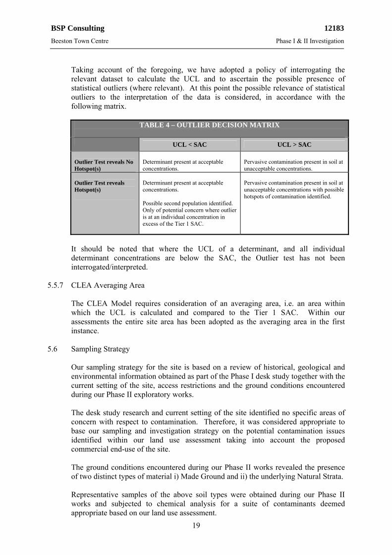
Taking account of the foregoing, we have adopted a policy of interrogating the relevant dataset to calculate the UCL and to ascertain the possible presence of statistical outliers (where relevant). At this point the possible relevance of statistical outliers to the interpretation of the data is considered, in accordance with the following matrix.
TABLE 4 – OUTLIER DECISION MATRIX
UCL < SAC UCL > SAC
Outlier Test reveals No Hotspot(s)
Determinant present at acceptable concentrations.
Pervasive contamination present in soil at unacceptable concentrations.
Outlier Test reveals Hotspot(s)
Determinant present at acceptable concentrations. Possible second population identified. Only of potential concern where outlier is at an individual concentration in excess of the Tier 1 SAC.
Pervasive contamination present in soil at unacceptable concentrations with possible hotspots of contamination identified.
It should be noted that where the UCL of a determinant, and all individual determinant concentrations are below the SAC, the Outlier test has not been interrogated/interpreted.
5.5.7 CLEA Averaging Area
The CLEA Model requires consideration of an averaging area, i.e. an area within which the UCL is calculated and compared to the Tier 1 SAC. Within our assessments the entire site area has been adopted as the averaging area in the first instance.
5.6 Sampling Strategy
Our sampling strategy for the site is based on a review of historical, geological and environmental information obtained as part of the Phase I desk study together with the current setting of the site, access restrictions and the ground conditions encountered during our Phase II exploratory works.
The desk study research and current setting of the site identified no specific areas of concern with respect to contamination. Therefore, it was considered appropriate to base our sampling and investigation strategy on the potential contamination issues identified within our land use assessment taking into account the proposed commercial end-use of the site.
The ground conditions encountered during our Phase II works revealed the presence of two distinct types of material i) Made Ground and ii) the underlying Natural Strata.
Representative samples of the above soil types were obtained during our Phase II works and subjected to chemical analysis for a suite of contaminants deemed appropriate based on our land use assessment.
BSP Consulting 12183
Beeston Town Centre Phase I & II Investigation
20
5.7 Contamination Analysis
A total of eight standard chemical contamination tests were carried out on selected samples of the Made Ground (5No.) and the underlying Natural Strata (3No.). The suite of contaminants tested for was based on the requirements of the CLEA guidance (i.e. to provide a general screening for the presence of common chemical contaminants) and in accordance with our land use assessment.
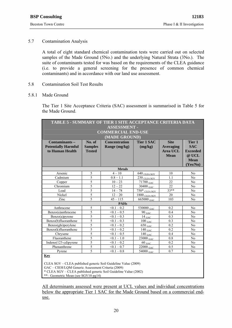
5.8 Contamination Soil Test Results 5.8.1 Made Ground
The Tier 1 Site Acceptance Criteria (SAC) assessment is summarised in Table 5 for the Made Ground.
TABLE 5 - SUMMARY OF TIER 1 SITE ACCEPTANCE CRITERIA DATA
ASSESSMENT - COMMERCIAL END-USE
(MADE GROUND) Contaminants –
Potentially Harmful to Human Health
No. of Samples Tested
Concentration Range (mg/kg)
Tier 1 SAC (mg/kg)
Site Averaging Area UCL
Mean
Tier 1 SAC
Exceeded@ UCL Mean
(Yes/No) Metals
Arsenic 5 4 – 10 640 CLEA SGV 10 No Cadmium 5 0.8 – 1.1 230 CLEA SGV 1.1 No Copper 5 10 – 23 71700 GAC 22 No
Chromium 5 12 – 22 30400 GAC 22 No Lead 5 14 – 78 750* CLEA SGV 33** No
Nickel 5 12 – 20 1800 CLEA SGV 20 No Zinc 5 45 – 115 665000 GAC 103 No
PAHs Anthracene 5 <0.1 – 0.2 530000 GAC 0.2 No
Benzo(a)anthracene 5 <0.1 – 0.5 90 GAC 0.4 No Benzo(a)pyrene 5 <0.1 – 0.3 14 GAC 0.3 No
Benzo(b)fluoranthene 5 <0.1 – 0.3 100 GAC 0.3 No Benzo(ghi)perylene 5 <0.1 – 0.2 650 GAC 0.2 No
Benzo(k)fluoranthene 5 <0.1 – 0.2 140 GAC 0.2 No Chrysene 5 <0.1 – 0.5 140 GAC 0.4 No
Fluoranthene 5 <0.1 – 1.0 23000 GAC 0.8 No Indeno(123-cd)pyrene 5 <0.1 – 0.2 60 GAC 0.2 No
Phenanthrene 5 <0.1 – 0.7 22000 GAC 0.5 No Pyrene 5 <0.1 – 0.8 54000 GAC 0.7 No
Key CLEA SGV – CLEA published generic Soil Guideline Value (2009) GAC – CIEH/LQM Generic Assessment Criteria (2009) * CLEA SGV – CLEA published generic Soil Guideline Value (2002) **– Geometric Mean (see SGV10 pg14)
All determinants assessed were present at UCL values and individual concentrations below the appropriate Tier 1 SAC for the Made Ground based on a commercial end-use.
BSP Consulting 12183
Beeston Town Centre Phase I & II Investigation
21
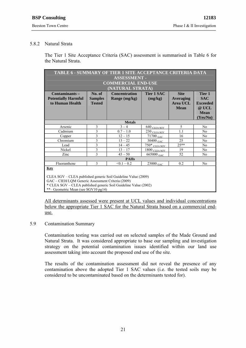
5.8.2 Natural Strata
The Tier 1 Site Acceptance Criteria (SAC) assessment is summarised in Table 6 for the Natural Strata.
TABLE 6 - SUMMARY OF TIER 1 SITE ACCEPTANCE CRITERIA DATA
ASSESSMENT - COMMERCIAL END-USE
(NATURAL STRATA) Contaminants –
Potentially Harmful to Human Health
No. of Samples Tested
Concentration Range (mg/kg)
Tier 1 SAC (mg/kg)
Site Averaging Area UCL
Mean
Tier 1 SAC
Exceeded@ UCL Mean
(Yes/No) Metals
Arsenic 3 3 – 4 640 CLEA SGV 5 No Cadmium 3 0.7 – 1.0 230 CLEA SGV 1.1 No Copper 3 12 – 15 71700 GAC 16 No
Chromium 3 13 – 22 30400 GAC 25 No Lead 3 14 – 45 750* CLEA SGV 25** No
Nickel 3 13 – 17 1800 CLEA SGV 19 No Zinc 3 43 – 50 665000 GAC 52 No
PAHs Fluoranthene 3 <0.1 – 0.2 23000 GAC 0.2 No
Key CLEA SGV – CLEA published generic Soil Guideline Value (2009) GAC – CIEH/LQM Generic Assessment Criteria (2009) * CLEA SGV – CLEA published generic Soil Guideline Value (2002) **– Geometric Mean (see SGV10 pg14)
All determinants assessed were present at UCL values and individual concentrations below the appropriate Tier 1 SAC for the Natural Strata based on a commercial end-use.
5.9 Contamination Summary
Contamination testing was carried out on selected samples of the Made Ground and Natural Strata. It was considered appropriate to base our sampling and investigation strategy on the potential contamination issues identified within our land use assessment taking into account the proposed end use of the site.
The results of the contamination assessment did not reveal the presence of any contamination above the adopted Tier 1 SAC values (i.e. the tested soils may be considered to be uncontaminated based on the determinants tested for).
BSP Consulting 12183
Beeston Town Centre Phase I & II Investigation
22
6.0 CONCEPTUAL SITE MODEL 6.1 General
The DEFRA publication ‘Environmental Protection Act 1990: Part 2A Contaminated Land Statutory Guidance’ (dated April 2012) states the following with regards to the production of a Conceptual Site Model (CSM) for a site:
‘The process of risk assessment involves understanding the risks presented by land, and the associated uncertainties. In practice, this understanding is usually developed and communicated in the form of a “conceptual model”’. The development of a CSM is typically undertaken in an iterative process, reflecting the changes in understanding as more detailed site information becomes available.
In developing a CSM, and specifically in the context of land contamination, consideration needs to be given to three essential elements; which form the basis of any risk present. The statutory guidance sections 3.8 and 3.9 (April 2012) states the following with respect to Part 2A.
‘Under Part 2A, for a relevant risk to exist there needs to be one or more contaminant-pathway-receptor [CPR] linkages – “contaminant linkage” – by which a relevant receptor might be affected by the contaminants in question. In other words, for a risk to exist there must be contaminants present in, on or under the land in a form and quantity that poses a hazard, and one or more pathways by which they might significantly harm people, the environment, or property; or significantly pollute controlled waters. For the purposes of this guidance:
(a) A “contaminant” is a substance which is in, on or under the land and which has
the potential to cause significant harm to a relevant receptor, or to cause significant pollution of controlled waters.
(b) A “receptor” is something that could be adversely affected by a contaminant, for example a person, an organism, and ecosystem, property, or controlled waters. The various types of receptors that are relevant under the Part 2A regime are explained in later sections.
(c) A “pathway” is a route by which a receptor is or might be affected by a contaminant.
The term “contaminant linkage” means the relationship between a contaminant, a pathway and a receptor. All three elements of a contaminant linkage must exist in relation to a particular land before the land can be considered potentially to be contaminated land under Part 2A, including evidence of the actual presence of contaminants. The term “significant contaminant linkage”, as used in this Guidance, means a contaminant linkage which gives rise to a level of risk sufficient to justify a piece of land being determined as contaminated land. The term “significant contaminant” means the contaminant which forms part of a significant contaminant linkage.’
BSP Consulting 12183
Beeston Town Centre Phase I & II Investigation
23
With respect to the presence of background levels of contaminants, section 3.21 to 3.23 states ‘The Part 2A regime was introduced to help identify and deal with land which poses unacceptable levels of risk. It was not intended to apply to land with levels of contaminants in soil that are commonplace and widespread throughout England or parts of it, and for which in the very large majority of cases there is no reason to consider that there is an unacceptable risk.
Normal levels of contaminants in soil should not be considered to cause land to qualify as contaminated land, unless there is a particular reason to consider otherwise. Therefore, if it is established that land is at or close to normal levels of particular contaminants, it should usually not be considered further in relation to the Part 2A regime...
For the purpose of this Guidance, “normal” levels of contaminants in soil may result from:
(a) The natural presence of contaminants (e.g. caused by soil formation processes
and underlying geology) at levels that might reasonably be considered typically in a given area and have not been shown to pose an unacceptable risk to health or the environment.
(b) The presence of contaminants caused by low level diffuse pollution, and common human activity other than specific industrial processes. For example, this would include diffuse pollution caused by historic use of leaded petrol and the presence of benzo(a)pyrene from vehicle exhausts, and the spreading of domestic ash in gardens at levels that might reasonably be considered typical.’
In selecting appropriate generic assessment criteria Section 3.27 of the Guidance states:
‘It is common practice in contaminated land risk assessment to use “generic assessment criteria” (GACs) as screening tools in generic quantitative human health risk assessment to help assessors decide when land can be excluded from the need for further inspection and assessment, or when further work would be warranted’.
With respect to assessing contaminated land, section 4.17 of the Guidance states:
‘In deciding whether or not land is contaminated land on grounds of significant possibility of significant harm to human health, the local authority should use the categorisations described in paragraphs 4.19 – 4.30 below. Categories 1 and 2 would encompass land which is capable of being determined as contaminated land on the grounds of significant possibility of harm to human health. Categories 3 and 4 would encompass land which is not capable of being determined on such grounds.’
In relation to the use of GAC values in the assessment of contaminated land, section 3.29 of the Guidance states:
‘GACs relating to human health risk assessment represent cautious estimates of levels of contaminants in soil at which there is considered to be no risk to health or, at most, a minimal risk to health. With regards to such GACs:
BSP Consulting 12183
Beeston Town Centre Phase I & II Investigation
24
(a) They may be used to indicate when land is very unlikely to pose a significant
possibility of significant harm to human health. This is on the basis that they are designed to estimate levels of contamination at which risks are likely to be negligible or minimal and far from posing a significant possibility of significant harm to human health.
(b) They should not be used as direct indicators of whether a significant possibility of significant harm to human health may exist. Also, the local authority should not view the degree by which the GACs are exceeded (in itself) as being particularly relevant to this consideration, given that the degree of risk posed by land would normally depend on many factors other than simply the amount of contaminants in soil.
(c) They should not be seen as screening levels which describe the boundary between Categories 3 and 4 in terms of Section 4 (i.e. the two Categories in which land would not be contaminated land on grounds of risk to human health). In the very large majority of cases, these SGVs/GACs describe levels of contamination from which risks should be considered to be comfortably within Category 4.
(d) They should not be viewed as indicators of levels of contamination above which detailed risk assessment would automatically be required under Part 2A.
(e) They should not be used as generic remediation targets under the Part 2A regime. Nor should they be used in this way under the planning system, for example in relation to ensuring that land affected by contaminated does not meet the Part 2A definition of contaminated land after it has been developed.’
In undertaking a risk assessment and deriving a CSM for the purposes of the redevelopment of a site (i.e. planning and development control) reference has been made to both the Model Procedures for the Management of Land Contamination, as well as the National Planning Policy Framework (NPPF, dated March 2012). Reference has also been made to the Contaminated Land Statutory Guidance (referenced above), although this is primarily concerned with Local Government determinations of Statutory ‘Contaminated Land’, which is separate to planning framework requirements.
6.2 CPR Considerations
The following CPR assessment has been undertaken based on the assumption that it is proposed to redevelop the site with a commercial end-use.
6.3 Consideration of Potential Sources of Contamination [C]
Based on the findings of the desk study and the ground conditions encountered during intrusive investigation works, the potential key sources of contamination at the site are considered to be the following:
Metals associated with Made Ground beneath the site. Natural Metal Enrichment (NME) in Natural Strata. Polyaromatic Hydrocarbons (PAH’s) derived from any ashy inclusions in the near
surface soils.
BSP Consulting 12183
Beeston Town Centre Phase I & II Investigation
25
6.4 Consideration of Potential Pathways [P]
The potential pathways at the site are primarily:
Direct ingestion of soil. Inhalation of dust and vapours. Direct skin contact with the ground. Direct contact with building materials. Vertical and lateral migration of contamination.
6.5 Consideration of Potential Receptors [R]
The potential receptors at the site are:
The construction personnel (i.e. site workers) involved with the development of the site (typically short term (acute) exposure).
The final end users (employees - typically long term (chronic) exposure and site visitors – typically short term (acute) exposure).
Controlled waters. Buildings/construction materials.
6.6 Summary
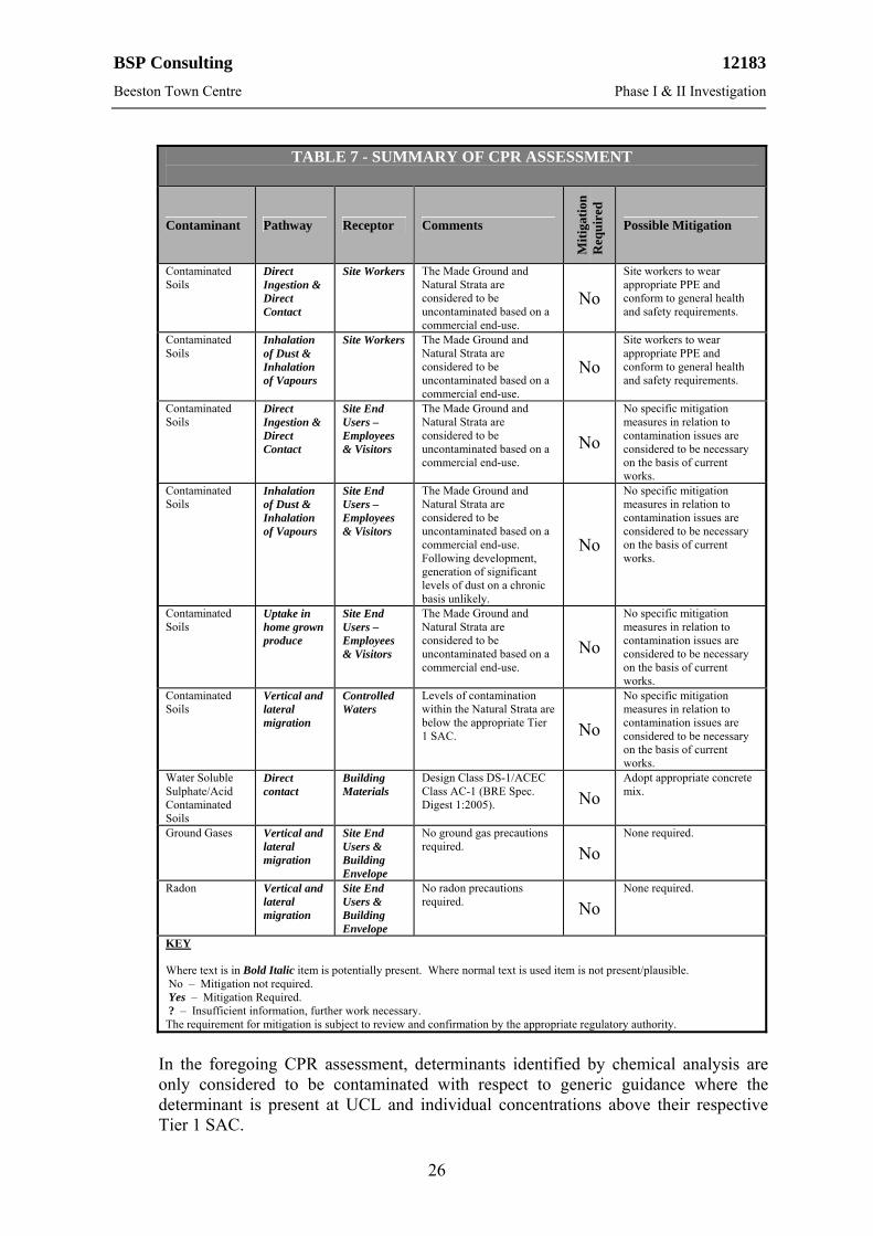
BSP Consulting’s conceptual site model of possible CPR pollutant linkages, applicable to the proposed site usage, to be addressed as part of the planning/redevelopment process, is summarised in Table 7.
BSP Consulting 12183
Beeston Town Centre Phase I & II Investigation
26
TABLE 7 - SUMMARY OF CPR ASSESSMENT
Contaminant Pathway Receptor Comments
Mit
igat
ion
R
equ
ired
Possible Mitigation
Contaminated Soils
Direct Ingestion & Direct Contact
Site Workers The Made Ground and Natural Strata are considered to be uncontaminated based on a commercial end-use.
No
Site workers to wear appropriate PPE and conform to general health and safety requirements.
Contaminated Soils
Inhalation of Dust & Inhalation of Vapours
Site Workers The Made Ground and Natural Strata are considered to be uncontaminated based on a commercial end-use.
No
Site workers to wear appropriate PPE and conform to general health and safety requirements.
Contaminated Soils
Direct Ingestion & Direct Contact
Site End Users – Employees & Visitors
The Made Ground and Natural Strata are considered to be uncontaminated based on a commercial end-use.
No
No specific mitigation measures in relation to contamination issues are considered to be necessary on the basis of current works.
Contaminated Soils
Inhalation of Dust & Inhalation of Vapours
Site End Users – Employees & Visitors
The Made Ground and Natural Strata are considered to be uncontaminated based on a commercial end-use. Following development, generation of significant levels of dust on a chronic basis unlikely.
No
No specific mitigation measures in relation to contamination issues are considered to be necessary on the basis of current works.
Contaminated Soils
Uptake in home grown produce
Site End Users – Employees & Visitors
The Made Ground and Natural Strata are considered to be uncontaminated based on a commercial end-use.
No
No specific mitigation measures in relation to contamination issues are considered to be necessary on the basis of current works.
Contaminated Soils
Vertical and lateral migration
Controlled Waters
Levels of contamination within the Natural Strata are below the appropriate Tier 1 SAC. No
No specific mitigation measures in relation to contamination issues are considered to be necessary on the basis of current works.
Water Soluble Sulphate/Acid Contaminated Soils
Direct contact
Building Materials
Design Class DS-1/ACEC Class AC-1 (BRE Spec. Digest 1:2005). No
Adopt appropriate concrete mix.
Ground Gases Vertical and lateral migration
Site End Users & Building Envelope
No ground gas precautions required. No
None required.
Radon Vertical and lateral migration
Site End Users & Building Envelope
No radon precautions required. No
None required.
KEY Where text is in Bold Italic item is potentially present. Where normal text is used item is not present/plausible. No – Mitigation not required. Yes – Mitigation Required. ? – Insufficient information, further work necessary. The requirement for mitigation is subject to review and confirmation by the appropriate regulatory authority.
In the foregoing CPR assessment, determinants identified by chemical analysis are only considered to be contaminated with respect to generic guidance where the determinant is present at UCL and individual concentrations above their respective Tier 1 SAC.
BSP Consulting 12183
Beeston Town Centre Phase I & II Investigation
27
7.0 CONCLUSIONS & RECOMMENDATIONS
The following conclusions and recommendations relate specifically to the proposed redevelopment of the units within the central area of the site. The conclusions and recommendations are subject to confirmatory trial pitting works following demolition of the existing buildings which occupy the majority of the redevelopment area.
7.1 Site Summary
The redevelopment area of the site comprises a row of terraced shops, fronted by a paved pedestrian walkway. It is understood that it is proposed to demolish the shops as part of the upcoming tram works and reconstruct further retail units in broadly the same location.
7.2 Site Geology
Geological information has revealed the site to be underlain by First Terrace deposits (Sands and Gravels). The First Terrace deposits are indicated to be underlain by the Nottingham Castle Sandstone Formation in the northern half of the site and the Mercia Mudstone Group in the southern half of the site.
7.3 Ground Conditions
The Made Ground typically comprised reinforced concrete up to 0.30m thick, overlying medium dense sandy fine to coarse gravel with some broken brick and broken concrete. The Made Ground was encountered to depths of 1.15m and 1.90m begl where fully penetrated.
The underlying Natural Strata typically comprised medium dense silty slightly gravelly fine to coarse SAND which became more dense with increased depth. In one location the sand was underlain by stiff slightly sandy CLAY from a depth of 2.45m begl.
7.4 Foundation Design
It is understood that the preferred foundation option for the proposed redevelopment is pads. Based on the intrusive works to date, the ground conditions at the site appear suitable to support a pad foundation solution. The natural soils underlying the site where present at typical minimum foundation depth, appear suitable to support a nett allowable ground bearing pressure of up to 150kN/m2. Based on the findings of the boreholes, but subject to recommended confirmatory trial pitting works following demolition (see Section 7.22), an increased nett allowable ground bearing pressure of up to 250kN/m2 may be achievable at greater depths in the region of 2.00m begl.
Due to the volume change potential of the localised cohesive soils, foundations should be advanced to a minimum depth of 0.75m below existing or proposed ground levels (whichever being the deeper) and founded within undisturbed suitably competent Natural Strata. Foundations may also require adjusting in accordance with BRE Digest 240 ‘Low-rise buildings on shrinkable clay soils: Part 1’ (1993).

BSP Consulting 12183
Beeston Town Centre Phase I & II Investigation
28
Where Made Ground is encountered at founding depth, foundations will require further deepening to encounter underlying undisturbed suitably competent natural soils. Made Ground has been encountered in boreholes to a depth of 1.90m begl within the site. Localised deeper Made Ground may be present due to historical foundations and/or services that may be present, associated with the existing buildings at the site.
Taking account of the presence of both cohesive soils (i.e. Clay) and granular soils (i.e. Sand), nominal mesh reinforcement may be required within foundations straddling the interface between granular and cohesive soils to minimise the potential for differential settlement. Alternatively, foundations straddling the interface between cohesive and granular soils may be deepened to found within a single bearing stratum.
Alternative foundations such as strip footing, trench fill or piles may also be considered feasible subject to the development loadings and building constraints.
All foundations should be designed to maintain the integrity of both adjacent properties and properties within an influencing distance of the redevelopment area. See also ‘Party Wall Issues’ (Section 7.18).
7.5 Floor Slab Design
Floor slab construction may be ground bearing, suspended floors with a clear ventilated void (i.e. beam and block) or concrete cast in-situ suspended slabs. Due to the anticipated presence of Made Ground across the redevelopment area, formation soils should be proof rolled and soft spots removed before a ground bearing floor slab would be appropriate. Floor slabs may require Engineer designed reinforcement subject to anticipated loadings within the proposed commercial units.
7.6 Radon
No radon precautions will be required at the site. 7.7 Ground Gas
No ground gas precautions relating to carbon dioxide or methane will be required at the site.
7.8 Building Near Trees
Foundation designs may require adjusting due to the effects of trees in accordance with BRE Digest 240 ‘Low-rise buildings on shrinkable clay soils: Part 1’ (1993). The cohesive (Clay) soils should be assumed to be of ‘low’ volume change potential when calculating foundation depths (based on laboratory testing). We would note that no trees or significant vegetation were present within the site or within an influencing distance of the site during our recent site walkover.
BSP Consulting 12183
Beeston Town Centre Phase I & II Investigation
29
7.9 Water
Groundwater seepages were absent from the exploratory holes advanced at the site. On this basis, the requirement for dewatering of excavations is not anticipated. Excavations within shallow cohesive soils may be susceptible to standing water following periods of wet weather.
7.10 Excavations
The window sample boreholes remained generally stable during their advancement, without the need for casing. The hand dug trial pits generally remained stable during their excavation and for the short period of time they remained open following completion.
However, based on the variable nature of the Made Ground, excavations may require trench support when excavating through these soils. A detailed assessment of the potential need for trench support will be made after the completion of the recommended confirmatory trial pitting works following demolition. The assessment of excavations and provision of support will be the responsibility of the contractor on site.
The natural cohesive soils are likely to be subject to deterioration and softening if excavations are left open and exposed to wet weather. Any softened soils should be removed from excavations prior to the pouring of concrete and foundation construction.
7.11 Sulphate Classification
In accordance with BRE Special Digest 1 (2005), the site falls into Design Sulphate Class DS-1 and an Aggressive Chemical Environment for Concrete (ACEC) classification of AC-1. Therefore, an appropriate concrete mix should be adopted in accordance with BRE Special Digest 1 for all buried concrete in contact with the ground.
7.12 Coal Mining
No coal mining precautions or associated investigation works are required at the site. 7.13 CBR’s
A value of less than 2% may be anticipated in the Made Ground and values of between 2% and 4% may be anticipated for the Natural Strata, subject to confirmation by in-situ testing.
7.14 Surface Water Drainage
The site may be suitable for the use of soakaways subject to in-situ testing in accordance with BRE 365 ‘Soakaway Design’, following demolition. However, soakaways should not be placed within 5m of buildings and therefore locating soakaways may be difficult at the site.
BSP Consulting 12183
Beeston Town Centre Phase I & II Investigation
30
7.15 Contamination Assessment
Contamination testing was carried out on selected samples of the in-situ soils (i.e. the Made Ground and Natural Strata). It was considered appropriate to base our sampling and investigation strategy on the potential contamination issues identified within our land use assessment taking into account the proposed end-use and the historical use of the site.
The results of the contamination assessment did not reveal the presence of any contamination above Tier 1 SAC. Therefore, the soils may be regarded as uncontaminated with regards to a proposed commercial end-use.
7.16 Remediation Proposals 7.16.1 Introduction
It is considered that taking account of the current setting of the site and development proposals, human health should be the principal driver for any remediation works based on the proposed commercial end-use of the site.
However, the chemical analysis has revealed the soils to be uncontaminated with respect to the determinants tested and we understand that the proposed development comprises entirely hard standing. Therefore, no remediation works will be required at the site.
7.16.2 Re-use of Material (off-site)
Consideration may be given by the Client for the use of any excess volumes of Natural Strata on other sites currently being redeveloped by the Client, that are in need of suitable capping materials (subject to the approval of the relevant Local Authority responsible for the area being redeveloped).
7.16.3 Off Site Disposal & Waste Acceptance Criteria Testing
If off-site disposal is required, the chemical testing regime can be different to the chemical testing required to assess the suitability of the soils for retention on site and the risks to human health. Therefore, a new contamination assessment may be required to include bespoke leachate analysis (i.e. Waste Acceptance Criteria [WAC] testing) to classify the soils for off-site disposal with testing criteria to assess whether the soil is hazardous, non-hazardous or inert waste. However, the existing chemical test data will assist this process.
If disposal is necessary then the environmental laboratory test results (included within Appendix F) should be provided to several landfill operators for consideration and cost provision in the first instance, prior to the material being removed from the site.

BSP Consulting 12183
Beeston Town Centre Phase I & II Investigation
31
7.16.4 Existing Buildings/Areas of Hardstanding
It is anticipated that significant quantities of demolition rubble will be generated during the demolition of the existing buildings including areas of hardstanding at the site. Depending on finished levels, it may be possible re-use some of these materials within the proposed development assuming that they can be crushed to the required grading. Alternatively there will be a requirement to remove these materials from site to a suitably licensed tipping facility.
It is recommended that an asbestos survey of the existing buildings is carried out by a suitably licensed contractor prior to any demolition works.
7.17 Licenses, Registrations, Permits and Approvals
The Contractor/Developer is responsible for, and must ensure that, all necessary licenses, permits, registrations, plans and approvals are in place prior to commencing with the earthworks at the site.
These will include any Mobile Treatment Licenses (MTLs), Site Waste Management Plans/Materials Management Plans and/or Waste Management Licenses/Exemptions as necessary to enable the completion of the proposed works.
7.18 Party Wall Issues
Sections of the site proposed for redevelopment are formed by the wall of adjacent commercial properties which we understand are to be retained. Consequently, there may be issues relating to the Party Wall Act 1996 (or successor) which apply to the proposed development. It is recommended that advice from a Party Wall Surveyor is sought to clarify and address this issue.
7.19 Unforeseen Circumstances
Should any areas of potentially contaminated soil be encountered during site construction works that appear significantly different to those encountered during the investigation we would recommend consultation with BSP Consulting, to ensure that our recommendations continue to apply. Any potentially contaminated soils should be left in-situ and subjected to further assessment, to potentially include chemical testing and risk assessment.
The following procedure should be adhered to if any areas of previously unidentified suspected contamination are encountered during the development of the site.
i. Suspected contaminated material will remain in-situ. ii. BSP to be notified, and will deal with as deemed appropriate. iii. BSP will undertake a visual assessment of the possible contamination,
followed by appropriate sampling/testing. iv. If necessary, contamination will then be removed from site or treated in-situ,
as appropriate.
BSP Consulting 12183
Beeston Town Centre Phase I & II Investigation
32
7.20 Construction Workers
No contamination has been identified that requires specific PPE equipment, however it is recommended that construction personnel involved with direct contact with the soils at the site use appropriate PPE equipment (i.e. gloves and overalls) together with welfare facilities in accordance with general health and safety guidelines.
A copy of this report should be included in the site health and safety file, and site workers should be made fully aware of the sites setting.
7.21 Utilities
We would recommend that a copy of this report is supplied to utility companies, and that their recommendations relating to appropriate supply pipes are adhered to.
7.22 Recommended Further works
At this stage, the following further works are recommended for the site:
Confirmation of the ground conditions (by means of mechanically excavated trial pits) beneath the footprints to the existing buildings following demolition.
Confirmation of the foundation details to the properties adjacent to the proposed redevelopment area.

Project No. Drawn SS Client Checked
Approved Project Scale NTS
Date Drawn 23/01/2013
Title Hand Dug Trial Pit 1
Figure No. 12183/05
Beeston Town Centre
Rev.
12183Henry Boot Developments
RedBrick
0.15m
0.80m
0.55m
0.08m
Wall toExisting Building
Existing Ground Level
Made Ground comprisingmedium dense very sandy fine tocoarse rounded to angular gravel
with some bricks, brick fragments andoccasional broken concrete
Concrete
?
PurpleBrick
Disturbed Samples recovered:T1 @ 0.30mT2 @ 0.80m
Approximate Extentof Trial Pit
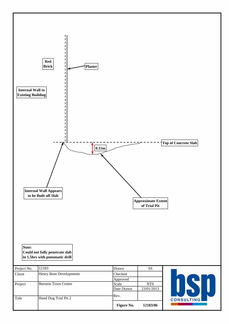
Project No. Drawn SS Client Checked
Approved Project Scale NTS
Date Drawn 23/01/2013
Title Hand Dug Trial Pit 2
Figure No. 12183/06
Beeston Town Centre
Rev.
12183Henry Boot Developments
RedBrick
0.15m
Internal Wall toExisting Building
Plaster
Top of Concrete Slab
Approximate Extentof Trial Pit
Internal Wall Appearsto be Built off Slab
Note:Could not fully penetrate slabin 1.5hrs with pneumatic drill

Depth &LegendDepth (Thickness)
Project No.
Type Sample SPT(m) Ref "N"
Value
Samples and TestsDescription of Strata
(m)Casing
(m)Ground-
water Installation
Remarks:
Project:Logged:Date:
Client:Checked:Approved:
Field Book Ref:Plant:Scale:
Drawing Ref:
Key: DUBJW
=====
Disturbed SampleUndisturbed SampleBulk SampleJar SampleWater Sample
SC
==
SPT Split Spoon TestSPT Cone Test
==
Water Strike (m)
Steady Water Level (m)
1.Sides generally stable.2.No groundwater encountered.
Beeston Town CentreSS19/12/2012 SS/04
Henry BootCompetitor Rig
WS112183
WS1
0.50
1.00-1.45
1.952.00-2.45
2.05
2.50
3.00-3.45
D
C
DCB
B
C
T3
T4
B1
B2
12
20
50/170mm
0.15
(1.75)
1.90
(0.55)
2.45
(0.55)
3.00
Reinforced concrete(MADE GROUND)
Medium dense grey and brown very sandy fine tocoarse gravel with much broken brick and brokenconcrete(MADE GROUND)
Medium dense brown silty slightly gravelly fine tocoarse SAND. Gravel is fine to coarse and rounded tosubrounded(FIRST TERRACE SANDS AND GRAVELS)
Stiff grey-brown slightly sandy CLAY(MERCIA MUDSTONE GROUP)
...becoming very stiff with depth
End of Borehole at 3.00 m
1:25
Sheet 1 of 1
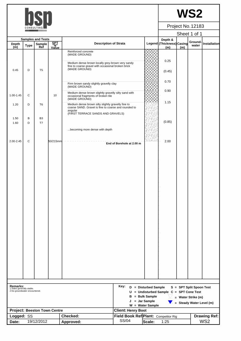
Depth &LegendDepth (Thickness)
Project No.
Type Sample SPT(m) Ref "N"
Value
Samples and TestsDescription of Strata
(m)Casing
(m)Ground-
water Installation
Remarks:
Project:Logged:Date:
Client:Checked:Approved:
Field Book Ref:Plant:Scale:
Drawing Ref:
Key: DUBJW
=====
Disturbed SampleUndisturbed SampleBulk SampleJar SampleWater Sample
SC
==
SPT Split Spoon TestSPT Cone Test
==
Water Strike (m)
Steady Water Level (m)
1.Sides generally stable.2.No groundwater encountered.
Beeston Town CentreSS19/12/2012 SS/04
Henry BootCompetitor Rig
WS212183
WS2
0.45
1.00-1.45
1.20
1.501.60
2.00-2.45
D
C
D
BD
C
T5
T6
B3T7
10
50/215mm
0.25
(0.45)
0.70
0.90
1.15
(0.85)
2.00
Reinforced concrete(MADE GROUND)
Medium dense brown locally grey-brown very sandyfine to coarse gravel with occasional broken brick(MADE GROUND)
Firm brown sandy slightly gravelly clay(MADE GROUND)
Medium dense brown slightly gravelly silty sand withoccasional fragments of broken tile(MADE GROUND)
Medium dense brown silty slightly gravelly fine tocoarse SAND. Gravel is fine to coarse and rounded toangular(FIRST TERRACE SANDS AND GRAVELS)
...becoming more dense with depth
End of Borehole at 2.00 m
1:25
Sheet 1 of 1
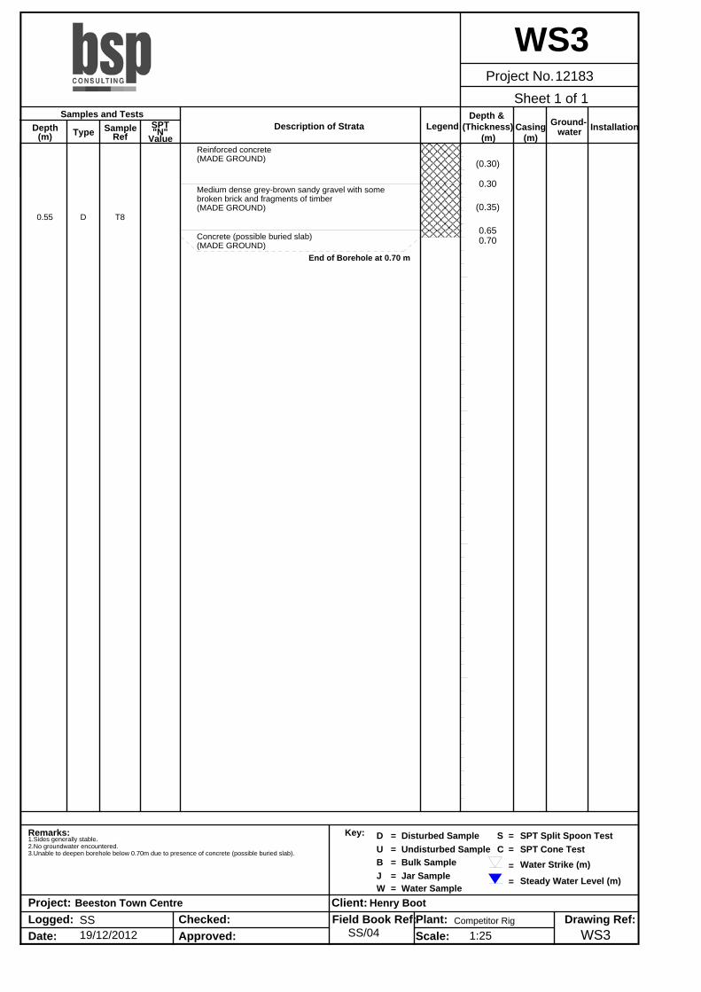
Depth &LegendDepth (Thickness)
Project No.
Type Sample SPT(m) Ref "N"
Value
Samples and TestsDescription of Strata
(m)Casing
(m)Ground-
water Installation
Remarks:
Project:Logged:Date:
Client:Checked:Approved:
Field Book Ref:Plant:Scale:
Drawing Ref:
Key: DUBJW
=====
Disturbed SampleUndisturbed SampleBulk SampleJar SampleWater Sample
SC
==
SPT Split Spoon TestSPT Cone Test
==
Water Strike (m)
Steady Water Level (m)
1.Sides generally stable.2.No groundwater encountered.3.Unable to deepen borehole below 0.70m due to presence of concrete (possible buried slab).
Beeston Town CentreSS19/12/2012 SS/04
Henry BootCompetitor Rig
WS312183
WS3
0.55 D T8
(0.30)
0.30
(0.35)
0.650.70
Reinforced concrete(MADE GROUND)
Medium dense grey-brown sandy gravel with somebroken brick and fragments of timber(MADE GROUND)
Concrete (possible buried slab)(MADE GROUND)
End of Borehole at 0.70 m
1:25
Sheet 1 of 1