
BAYFIELD CHURCH : RESISTIVITY SURVEY 1998
13
30 BAYFIELD CHURCH : RESISTIVITY SURVEY 1998 By Peter Camell and John Wright One of the members of the Blakeney Area Historical Society, Dr Peter Carnell, has recently developed an expertise in resistivity surveying and has agreed to help the Society to survey selected local sites. This report records the Àrst such survey and demonstrates that though the actual survey is relatively straightforward, interpretation of the Àndings is rather more difÀcult. At BayÀeld Church the resistivity readings show various archaeological features which cannot be identiÀed precisely but which provide an excellent focus for further study. INTRODUCTION The Location The resistivity survey was carried out at the ruined church of BayÀeld St Margaret (TG 0495 4049) which lies in the valley of the River Glaven some Àve kilometres from the north Norfolk coast. The former parishes of BayÀeld and neighbouring Glandford are now contained within the civil parish of Letheringsett. The church is within the emparked BayÀeld estate, close to the present Hall, and there is no public access. The Site At BayÀeld the Glaven runs north towards Cley and the church lies on the eastern side. The site slopes steadily down from east to west, and immediately beyond the west wall of the nave slopes very steeply to the terrace on which stands the Hall. The surroundings are maintained as mown grass although to the south there is one tree with a substantial root (or fallen trunk) some 6 metres from the chancel wall. In the nave is the low stump of a large cedar tree and some shrubs have been planted adjacent to some of the outer walls. In the chancel (at the time of the survey) there was stone work lying on the ground, much of it known to be extraneous. There is no sign of a churchyard. The Church Although the church is now rooÁess, a substantial amount of walling survives, some of it to full height (principally the west wall, still surmounted by a two-bay bellcote, and the chancel arch). The present structure consists of a chancel and a slightly wider nave, with no sign of a tower, and with total outer dimensions of c.18m by 6m. There are opposing doorways in the nave, towards the western end, and a further opening in the nave south wall. Outside the church and close to the northern doorway there is a small (relatively recent) retaining wall at right angles to the nave wall. The structure is in good condition with repairs recently carried out under a programme established by Norfolk County Council. Site History The former village of BayÀeld was one of the smallest in Holt Hundred at the time of Domesday with 13 recorded adults, mostly freemen, which might indicate a total of some 50 to 60 people. In 1329, not long before the Black Death, there were 27 taxpayers, which
Transcript of BAYFIELD CHURCH : RESISTIVITY SURVEY 1998

30
BAYFIELD CHURCH : RESISTIVITY SURVEY 1998
By Peter Camell and John Wright
One of the members of the Blakeney Area Historical Society, Dr Peter Carnell, has recentlydeveloped an expertise in resistivity surveying and has agreed to help the Society to surveyselected local sites. This report records the rst such survey and demonstrates that though theactual survey is relatively straightforward, interpretation of the ndings is rather moredif cult. At Bay eld Church the resistivity readings show various archaeological featureswhich cannot be identi ed precisely but which provide an excellent focus for further study.
INTRODUCTION
The Location
The resistivity survey was carried out at the ruined church of Bay eld St Margaret (TG 04954049) which lies in the valley of the River Glaven some ve kilometres from the north Norfolkcoast. The former parishes of Bay eld and neighbouring Glandford are now contained withinthe civil parish of Letheringsett. The church is within the emparked Bay eld estate, close tothe present Hall, and there is no public access.
The Site
At Bay eld the Glaven runs north towards Cley and the church lies on the eastern side. Thesite slopes steadily down from east to west, and immediately beyond the west wall of the naveslopes very steeply to the terrace on which stands the Hall. The surroundings are maintainedas mown grass although to the south there is one tree with a substantial root (or fallen trunk)some 6 metres from the chancel wall. In the nave is the low stump of a large cedar tree andsome shrubs have been planted adjacent to some of the outer walls. In the chancel (at the timeof the survey) there was stone work lying on the ground, much of it known to be extraneous.There is no sign of a churchyard.
The Church
Although the church is now roo ess, a substantial amount of walling survives, some of it tofull height (principally the west wall, still surmounted by a two-bay bellcote, and the chancelarch). The present structure consists of a chancel and a slightly wider nave, with no sign of atower, and with total outer dimensions of c.18m by 6m. There are opposing doorways in thenave, towards the western end, and a further opening in the nave south wall. Outside thechurch and close to the northern doorway there is a small (relatively recent) retaining wall atright angles to the nave wall. The structure is in good condition with repairs recently carriedout under a programme established by Norfolk County Council.
Site History
The former village of Bay eld was one of the smallest in Holt Hundred at the time ofDomesday with 13 recorded adults, mostly freemen, which might indicate a total of some 50to 60 people. In 1329, not long before the Black Death, there were 27 taxpayers, which

31
suggests some increase in population, but by 1429 there were fewer than 10 households and in1524 only two people paid tax. By 1603 there was only one house in the parish. The Hall isElizabethan in origin with later alterations and additions, including the south front of c.l740.lThe Park was begun before 1781. The site of the former village is not known nor whetherthere was any extensive landscaping in the vicinity of the church.
Church History
The structural history of the church has been studied most recently by Stephen Heywood,whose conclusions were published in 1995.2 He suggests that the earliest building of whichtraces remain was Romanesque, consisting of a chancel with an apsidal east end and a nave some 3m shorter than the present one. In the 14th or 15th century the apse was replaced by thecurrent chancel and the nave extended. There is also good evidence for the construction of achapel on the southern side of the chancel. In the post-medieval period the chancel arch wasblocked and the side chapel demolished. The church is known to have been in use in 1603 butwas probably abandoned soon after; Faden’s map published in 1797 shows the church as aruin. Some of its features make it an important building but it is not a Scheduled AncientMonument.
Heywood comments that the simple Romanesque two-cell chapel with apse was a commonsight in East Anglia until the end of the 12th century, when many were expanded with theaddition of towers and aisles. At Bay eld, however, the side chapel is unusual in being on thesame eastern plane as the chancel. The size of the chapel is not known and “it may be that asimple geophysical survey would establish it.”
Previous Fieldwork
In the Sites and Monuments Record (SMR) held by Norfolk Landscape Archaeology atGressenhall there is no record of eldwork on site except for an excavation undertaken in1956 by D.R.Howlett of the Castle Museum, Norwich. This is said to have uncovered thebase of the font and some tiles in the nave and tile impressions on the chancel step but, todate, no contemporary report of this excavation has been located.
Survey Objectives
The survey was organised by the Blakeney Area Historical Society and led by one of itsmembers, Dr Peter Carnell, who had practical experience of building and using resistivityequipment. Bay eld Church had been one of several sites under consideration for resistivitysurveys: there were possible features to be located for which resistivity techniques would beappropriate, and site conditions were suitable. Having received the support of the landowner,the Society decided to initiate the survey and two speci c objectives were selected: to locatethe side chapel and the position of the earlier western wall. Any further work, and theselection of appropriate techniques, would be considered in the light of the survey ndings.
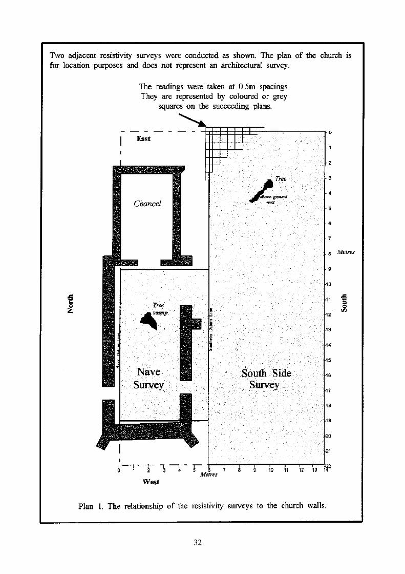
Survey Extent
Two contiguous surveys were planned: one inside the nave and one immediately to the southof the church. The inner survey was to cover the whole of the nave. The outer survey wasdesigned to exceed slightly the whole length of the church from east to west, and to extendaway southwards from the church for as far as could be achieved during the half-day period of
32

33
survey. It was considered that covering such an area would provide a good contrast betweenany constructional features associated with the church and the more natural conditions to beexpected elsewhere.
THE SURVEY
Date
The survey was carried out on Saturday, 4th April 1998 between midday and 4.0 pm.
Society members were augmented by others with more experience of resistivity surveying anda total of 12 people were present on site during the day, organised in two teams.
Weather
There had been some rain in the previous few days and during the morning of the survey butdrying conditions prevailed while the survey was in progress. Temperatures had remainedabove freezing during the previous night.
Grid Location
Two parallel and contiguous grids were established, one for each of the two surveys (Naveand South Side). The rst grid was laid out in the nave with an origin at the NE comer. Adatum line was set out 50cm from the north wall starting 10cm from the wall incorporatingthe chancel arch. A rectangle (of the maximum size possible in half metres) was marked outin the nave based on a triangulated right angle at the origin.
The second grid, for the South Side survey, was established by means of a datum line parallelto that of the nave grid and close to the outer side of the south wall. Again, the origin was atthe NE comer where a right angle was set out by triangulation.
The two grids are shown on Plan 1. The surveys were combined for computer processing.
Instruments
The equipment used was a purpose-built resistivity meter and a twin-probe array with themoving electrodes set 50cm apart. The static remote probes were placed some 60 metres fromthe church. The meter used an alternating polarity constant current source in such a way thatresistivity was displayed directly in millivolts.
Each resistivity reading represents a measurement of the resistance of the subsoil in thevicinity of the probes to the passage of an electrical current. Wetter ground allows morecurrent to pass: it has a lower resistance. Conversely, dry ground (which may contain buildingfoundations, for example) has a higher resistance. The pattern of readings, therefore, showssubsoil moisture differences across the surveyed area, for whatever reason, and it is thesechanges which are the important feature – actual values are of much less consequence.

34
Plan 2, The data as recorded. The colour range, as shpwn in the key, represents a value range extending from the highest (243) to the lowest (93) recorded.

35
Readings
Single readings were taken at 50cm intervals over the whole of the two grids, except wherestructures or trees intervened (speci cally the nave south wall and the tree stump in the nave).Within the nave, all transits were made from East to West, with a nal transit grazing theinner side of the south wall. This rst survey was then completed by two partial transitswithin the south wall opening and a nal complete one outside the south wall, adjacent to the
rst transit of the South Side survey. For this second survey transits were made alternatelyfrom East to West and from West to East.
In the Nave Survey 217 readings were taken, a further 35 being prevented by the south walland the tree stump; in the South Side survey 762 readings were taken, omitting 3 because of atree, making 979 in all. The gross area covered by the two surveys was 60 sq m and 176 sq m,a total of 236 sq m.
The readings were recorded manually on prepared data sheets at a xed control table, andwere later keyed into a computer and processed with a statistical package (MATHCAD).
Although the readings are taken at points, they represent ground moisture conditions in avolume of soil and are better shown as areas. Plan 1 shows that any presentation of points as0.5m squares will mean that the data display will cover an area slightly larger than the actualsurvey grid.
RESULTS
Description
The readings taken over the site are displayed in colour on Plan 2. The actual values rangefrom 93 to 243 and each is shown correctly in the appropriate colour within the spectrum – there is no grouping into pre-determined categories. The gures on the scale indicate therelationship between value and colour. Where no readings could be taken the grid squares areare shown uncoloured.
The plan shows clear patterns in both the Nave and the South Side surveys. The nave isdominated by an area of high resistivity (ie drier conditions) between the two doorways, withthe highest values in the middle. A second drier area lies within the larger opening in the navewall, and a third, less intense, around and to the north of the tree stump.
Outside the church lie two well-de ned features. The larger one is an area of dry groundextending 4-5 metres south of the nave, from just beyond the eastern end of the church andwestward to the northern doorway of the nave. Within this area the values nearest the nave aregenerally higher than those opposite the chancel and are particularly high in the vicinity of theopening in the nave south wall. The second feature is a drier area, linear in form and c.1.5mwide, extending North-South just downslope from the present west wall of the church.
In the areas away from these two features there is a steady downward drift in values (ie wetterconditions) towards the South-East.

36
Plan 3. Enhanced data. The grey scale range, as shown in the the key, represents a value rangeextending from <140 to >200.

37
INTERPRETATION
The Nave Survey
Plan 2 shows a particularly high (ie dry) reading in a half-metre (red) square equidistantbetween the two doorways of the nave. This is in the area where Hewlett reported nding thebase of a font in 1956. The SMR entry records that the font soakaway was discovered in theform of a hole one metre in diameter and lled with glacial ints, and partly covered byglazed tiles in an arrangement indicating an octagonal font. A small sketch of this appears inthe guidebook to Letheringsett church but the details are by no means clear.
Plan 3 is a higher contrast, grey scale, version of Plan 2: the value range has been restricted to140-200 so that all values outside that range are shown as either 140 or 200. The font areashows up more clearly here as a dry area surrounding a sub-rectangular, wetter area c. 1 metresquare. These ndings cannot be interpreted more precisely but they appear to be consistentwith the reported ndings of Hewlett’s excavation.
Heywood’s suggestion that the nave was extended to the west implies that traces of the earlierwestern wall should exist below ground – locating such a feature was one of the mainobjectives of the survey. If this feature is present in Plan 3 then it probably lies directlybetween the two doorways, although interpretation is complicated by the superimposition ofthe font, and possibly by disturbance during the excavation.
Plan 3 shows a strong linear feature in the gap in the south wall of the nave. This cancon dently be interpreted as the base of the former wall continuing the line of the existingone. This feature appears not to connect with the east wall of the nave: the high readings arefollowed by a nal low one (and to the casual eye the east wall of the nave seems to continueto the south rather than return to the west).
However, this apparent ‘gap’ almost certainly has another interpretation. Plan 3 shows thatalong the inside of the nave walls are groups of both white (wetter) and darker (drier) squares.The white squares are adjacent to the highest of the remaining walls, while the darker squaresadjoin openings or lower sections of walling. The implication is that more rain runs down thehigher walls and creates wetter conditions at the base compared with drier ground conditionsassociated with the lower walls.
The remaining feature in the nave is the tree stump which prevented readings in 5 squares.The darker squares immediately adjacent are probably caused by the relatively non-conducting nature of the remaining roots.
South Side
The principal objective of the survey was to trace the outline of the suspected chapel on thesouth side of the chancel. Plan 3 shows that such traces are present but dif cult to de ne.There is a suggestion of an east-west linear feature some 4m from the chancel wall, very closeto the limit of the chapel envisaged by Heywood. This could mark the foundations of a wall.Plan 3 suggests the possibility of walls linking this feature to the chancel but the evidence isnot clear. Again, the wetter conditions close to the chancel could be masking survivingarchaeological features. The possibility of disturbance by tree growth and removal also needsto be taken into account as early photographs show a number of trees close to the church.

38

39
To the south of the supposed chapel, three readings were omitted because of a tree and a largesurface root. Immediately adjacent is a particularly high reading which, as shown by thestump in the nave, is more likely to be due to the existence of the tree than to somearchaeological feature.
Elsewhere on the southern side of the church are archaeological features best seen in Plan 2.Although there is a de nite pattern it is not clear how many features are present. The moststriking is the ‘arc’ of high readings opposite the gap in the nave wall. The values are thehighest on the site and are likely to represent solid material such as brick or int. The valueshere are much higher than those clearly indicating the continuation of the nave south wall.
Although a possible interpretation is rubble from the collapsed nave wall, the regularity of thefeature and the contrasting wetter conditions within suggest otherwise. It is probablysigni cant that the east-west ‘wall’ some 3m from the nave has a western return which alignswith a ‘buttress’ on the nave wall. Those who have studied the church previously appear notto have wondered why this buttress should be the only one or why it should be in thisposition. Plan 2 shows that the possibility of the buttress being the remaining section of a wallneeds to be considered. The return on the east side aligns with the east wall of the nave. The
ndings are therefore consistent with the construction of a ‘chapel’, or some other structure,associated with the present church.
Outside this feature is another characterised by moderately high readings, bounded byrelatively sharp edges (at right angles) on the south and east, and with a 2m square of lowerreadings within. The southern boundary of the feature is 4.5m from the nave wall. Thewestern arm aligns with the doorway in the nave and although it could represent a hardcorepath going right through the church, for example, the alignment could be coincidental.Similarly, the possible alignment with the earlier western wall of the nave would notnecessarily indicate a functional relationship. The possibility of another building cannot beruled out but there is no evidence to suggest its date or purpose. The 2m square of ‘wetter’readings is a convenient size to suggest the possibility of a burial. The eastern boundary ofany such building is unclear, as the traces become much less strong east of the central point ofthe ‘arc’. If an eastern boundary is indicated at this point then a path through some notionaldoorway in the ‘arc’ remains a possibility. Alternatively, the feature might extend eastwardsto join up with the chancel chapel.
A further feature on the south side, showing up most clearly on Plan 3, is the shallow curvejust to the west of and downslope from of the church. The appearance is consistent with theremains, or foundations, of a wall, probably buried by the downhill movement of topsoil. Inthis position it is more likely to be a boundary wall for the church than one associated withlandscaping in the park.
CONCLUSIONS
Summary
The survey was successful on several counts. The readings obtained were all considered valid– none had to be discarded as implausible – and the computer-based analysis produced someclear images. Yet the two main objectives of the survey, to nd the outlines of the chapel and

40
the earlier western wall, met with only tentative success. On the other hand, the surveyprovided evidence consistent with the font base already excavated and, more particularly,produced evidence for features not hitherto suspected. Their interpretation has given rise tomuch discussion (and some change of views) but ultimately a resistivity survey is notde nitive: a full account needs complementary evidence from other sources.
The main ndings of the survey are summarised on Plan 4.
Further Action
In order to take further the interpretation of the ndings some additional evidence is needed.This might be supplied by documentary records relating to the estate, by those already expertin church history or, ultimately, by test excavations. It might also be worth undertakingfurther resistivity surveys in order to explore particular aspects of the site such as:
• the boundary wall and its possible extension beyond the bounds of the present survey• the north side of the church where other structures might be found• a vertical resistivity sounding to determine the depth of features, distinguishing, for example, between shallow paths and deeper foundations.
These points will be considered by the Society in due course and a proposal for further workmay well be prepared.
Peter Camell founded and managed a major computer technology company, and has recentlydeveloped and applied geophysics equipment for archaeological investigations. John Wrightis a retired town planner who worked most recently for Norfolk County Council.
Acknowledgements
The Society wishes to thank Mr and Mrs R. Combe for permission to work on the site and for theirencouragement and practical support.
Notes
1 N.Pevsner and B.Wilson, The Buildings of England - Norfolk 1: Norwich and North East, Penguin, 2nd edition, 1997.
2 S.Heywood and J.Ayton, “Three Ruined Churches’, NAHRG Annual No. 4, 1995.
3 C.L.S.Lumell, Letheringsett-with Bay eld: Church and Parish, 1952 (with subsequent editions).

41
The church from the north-east
The church from the south-west

42
The chancel from the south
The nave and chancel from the south


