Bath Western Riverside East Environmental Statement, … · Bath Western Riverside East...
30
Bath Western Riverside East Environmental Statement, Non-Technical Summary Sainsbury’s Supermarkets Ltd. Bath Western Riverside East Environmental Statement Non-Technical Summary February 2013
Transcript of Bath Western Riverside East Environmental Statement, … · Bath Western Riverside East...

Bath Western Riverside East Environmental Statement, Non-Technical Summary
Sainsbury’s Supermarkets Ltd.
Bath Western Riverside East
Environmental Statement Non-Technical Summary February 2013


Bath Western Riverside East Environmental Statement, Non-Technical Summary .
Contents 1.0 Introduction ............................................................................ 4
1.1 Background ......................................................................... 4 1.2 Environmental Assessment ................................................... 4 1.3 Site Description .................................................................... 6
2.0 The Proposals .......................................................................... 7 2.1 Background and Need .......................................................... 7 2.2 Alternatives ......................................................................... 7 2.3 Description of the Development ............................................ 8 2.4 Construction Phases ........................................................... 10
3.0 Consultation .......................................................................... 12 3.1 Aims ................................................................................. 12 3.2 Methodology ...................................................................... 12 3.3 Consultation Conclusions .................................................... 14
4.0 Environmental Impacts .......................................................... 15 4.1 Socio-economics ................................................................ 15 4.2 Traffic and Transport ......................................................... 16 4.3 Air Quality ......................................................................... 17 4.4 Noise and Vibration ............................................................ 18 4.5 Light ................................................................................. 19 4.6 Ground and Groundwater ................................................... 20 4.7 Hydrology and Flood Risk ................................................... 21 4.8 Landscape, Townscape and Visual Impact Assessment ......... 22 4.9 Ecology ............................................................................. 25 4.10 Historic Environment .......................................................... 26
5.0 Summary .............................................................................. 28 5.1 Conclusions ....................................................................... 28 5.2 Management of Environmental Impacts ............................... 28 5.3 What happens next? .......................................................... 28
V001265 3

Bath Western Riverside East Environmental Statement, Non-Technical Summary .
1.0 Introduction
1.1 Background
1.1.1 This document summarises the Environmental Statement (ES) which accompanies the planning application by Sainsbury’s Supermarkets Ltd for the proposed mixed-use development of land at Bath Western Riverside East (BWR East). The development will represent a natural extension to Bath City Centre, delivering new retail facilities, employment floorspace, new homes, and substantial improvements to the environmental quality of the area.
1.1.2 This document is a summary of the Environmental Impact Assessment (EIA) process in non-technical language. The main Environmental Statement (ES) (Volume 1) and the supporting Appendices (Volume 2) contain detailed information on the project and each of the environmental topics considered.
1.2 Environmental Assessment
1.2.1 EIA is a formal process by which the likely environmental effects of a project are assessed, and where there is potential for a significant negative effect that cannot be avoided, works are identified to lessen the effects (mitigation). The ES reports on the findings of the EIA and sets out those areas where likely significant environmental effects have been identified and the mitigation proposed to remedy predicted effects. It forms an important part of the planning application decision making process.
1.2.2 The development falls under Schedule 2 (section 10b – urban development projects) of the EIA Regulations (The Town and Country Planning (Environmental Impact Assessment) Regulations 2011). The development will encourage more intensive activities on site, and due to the Site’s close proximity to environmentally sensitive habitats, and its location within a World Heritage Site (WHS), an EIA is required.
1.2.3 The topics to be included within the ES were established through a process known as ‘scoping’. Scoping involves a consideration of how the development could potentially impact on the local environment, and identifies those areas where those impacts might be significant.
1.2.4 The scoping process identified that the following topics should be assessed as part of this EIA:
• Socio-economics
• Traffic and Transport
• Air Quality
• Noise and Vibration
• Light
• Ground and Groundwater
• Hydrology and Flood Risk
• Landscape, Townscape and Visual Impact Assessment
• Ecology
• Historic Environment
V001265 4

Bath Western Riverside East Environmental Statement, Non-Technical Summary .
1.2.5 The EIA project team has been led by WYG consultants, with input from other specialists within the company together with external consultants, as set out below:
Role / Topic Author
ES Management and Co-ordination WYG
Planning Policy WYG
Socio-economics WYG
Traffic and Transport Connect Consultants
Air Quality WYG
Noise and Vibration WYG
Light WYG
Ground and Groundwater Tweedie Evans Consulting, Gary Gabriel Associates
Hydrology and Flood Risk Clive Onions
Landscape, Townscape and Visual Impact Assessment
Chetwoods, Spacehub, Indigo Landscape
Ecology WYG
Historic Environment WYG
V001265 5
Bath Western Riverside East Environmental Statement, Non-Technical Summary .
1.3 Site Description
1.3.1 The BWR East Site occupies approximately 5.9 hectares (ha) and is located on the western edge of Bath City Centre (Figure 1). The River Avon runs through the centre of the Site. Stanier Bridge connects the two parts of the Site, as shown on Figure 3. The bridge allows both vehicles and pedestrians easy access to the opposite bank and is well used throughout the day.
1.3.2 The site is well connected to the City Centre via James Street West, a popular pedestrian and bus route.
1.3.3 The land to the north of the river is currently occupied by the Green Park Station area, including the historic Grade II listed Station building, and a Sainsbury’s foodstore with associated level car park.
1.3.4 The land to the south of the river currently comprises of a Homebase retail unit with associated surface car park (some of which is shared with Sainsbury’s customers), a Sainsbury’s petrol filling station and a trade park.
1.3.5 The Site is relatively flat as it is already largely made up of buildings and hard standing features such as carparks.
Figure 1: Site location
V001265 6

Bath Western Riverside East Environmental Statement, Non-Technical Summary .
2.0 The Proposals
2.1 Background and Need
2.1.1 The site is located in a central part of the City that is destined to undergo significant change, driven by adopted and emerging planning and economic development policies seeking comprehensive regeneration. The site has recently been designated as part of the Bath ‘City of Ideas’ Enterprise Area. The transformation of this part of the city is already underway with Crest Nicholson building out the first phases of their housing led development of BWR that is expected to yield around 2000 new dwellings.
2.1.2 The site is a key regeneration opportunity that can contribute to development needs in the City Centre area. Development here is expected to be led by new economic and commercial activities benefitting from the central, sustainable location and representing the western expansion of the City Centre.
2.2 Alternatives
2.2.1 Sainsbury’s existing foodstore at BWR East is 30 years old. The trading location has proven to be highly advantageous and the foodstore’s popularity has resulted in very strong trading performance being consistently achieved over this period. The strong trading performance of the existing Sainsbury’s foodstore is a reflection of its highly-accessible location and proximity to the established City Centre.
2.2.2 In light of the above, Sainsbury’s requirement is to retain and improve its foodstore offer at BWR East.
2.2.3 Bath and North East Somerset (BANES) Council’s aspirations for the comprehensive redevelopment of BWR are long held. Importantly, the eastern end of BWR is proposed for the expansion of the City Centre, delivering commercial-led mixed-use development.
2.2.4 The above context is important from Sainsbury’s perspective. It provides the basis for incorporating the business requirement for an improved foodstore within a larger complementary development scheme. It enables Sainsbury’s to put forward a comprehensive proposal which incorporates land and assets within its ownership and control so that a commercially viable development scheme can be achieved.
2.2.5 As such, Sainsbury’s development proposals are site-specific and cannot be achieved at an alternative site.
2.2.6 Alternatives have been considered within the general context of the site’s allocation for comprehensive regeneration, its sustainable credentials, commercial requirements and viability, and local community / stakeholder engagement. The size, mix and location of the uses on the site have been carefully considered to ensure that stakeholders and the public’s aspirations and emerging policy aims for the site are met, whilst minimising likely environmental effects. Key concerns of stakeholders have been addressed during the evolution of the development proposals.
2.2.7 The Proposed Development has been progressed following a full assessment of the likely significant environmental effects, and incorporates various measures to mitigate these effects. The results of this detailed assessment are summarised in the following sections of this ES, Non Technical Summary.
V001265 7

Bath Western Riverside East Environmental Statement, Non-Technical Summary .
2.3 Description of the Development
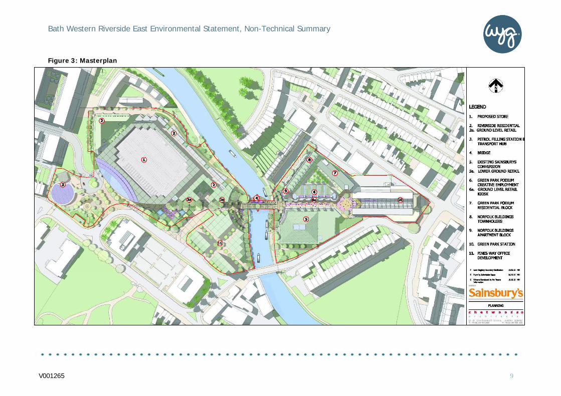
2.3.1 The Masterplan for the Proposed Development is shown at Figure 3. The key features of the proposal are:
• Demolition of the existing Homebase retail unit;
• Full details for the construction of a new Sainsbury’s foodstore of7,196m2 net retail floorspace, including first floor mezzanine andassociated parking for 605 cars at second and third floor levels;
• Full details for the construction of 214 residential apartmentsflanking the new foodstore along with ground floor retail / foodand drink units;
• Full details for the reconfiguration of Sainsbury’s petrol fillingstation;
• Full details of the conversion of Sainsbury’s existing foodstorebuilding for comparison goods retailing. It is proposed to besubdivided into 3 retail units, each providing 1,100-1,500sqm netfloorspace (total net floorspace is 3963sqm). Additionally, a smallcafé unit is proposed alongside the river at lower ground level,as part of the building’s conversion;
• Outline proposals for mixed-use development blocks aboveretained parking at Green Park Station, comprising 11townhouses, 55 residential apartments (containing a mix ofaffordable and open market housing), circa 2,400 m2 creativeemployment space, and small-scale retail / food and drink ‘kiosk’units;
• Outline proposals for the redevelopment of the Pines WayIndustrial Estate site to provide around 10,630m2 gross officefloorspace, potentially incorporating an element of mixed use;and
• Co-ordinated public realm, landscaping, and access worksincluding new public transport hub, linear park alongside theriver, central parade, enhanced river crossing and a new civicsquare in front of the Green Park Station building.
Figure 2: Early site plans
V001265 8
Bath Western Riverside East Environmental Statement, Non-Technical Summary .
Figure 3: Masterplan
V001265 9
Bath Western Riverside East Environmental Statement, Non-Technical Summary .
2.4 Construction Phases
2.4.1 The planning application is a hybrid with some elements seeking detailed consent and others outline. Therefore a fully detailed construction programme has not been able to be developed at this stage.
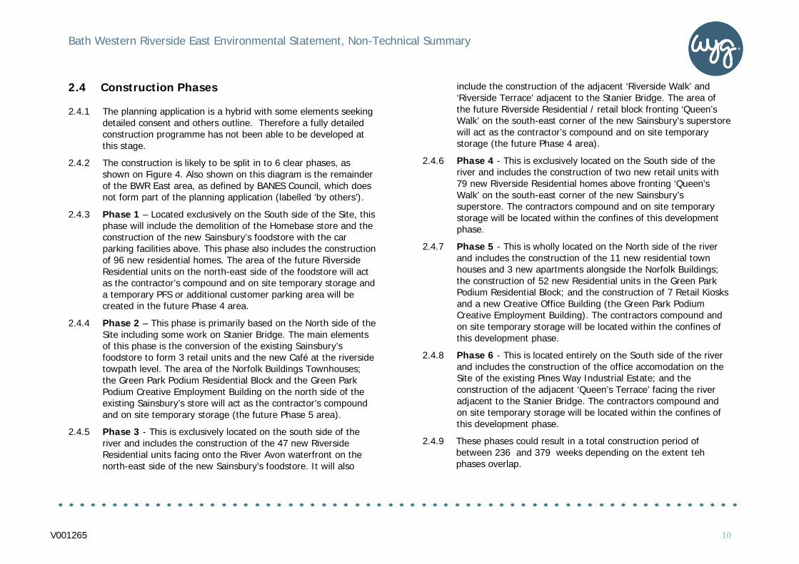
2.4.2 The construction is likely to be split in to 6 clear phases, as shown on Figure 4. Also shown on this diagram is the remainder of the BWR East area, as defined by BANES Council, which does not form part of the planning application (labelled ‘by others’).
2.4.3 Phase 1 – Located exclusively on the South side of the Site, this phase will include the demolition of the Homebase store and the construction of the new Sainsbury’s foodstore with the car parking facilities above. This phase also includes the construction of 96 new residential homes. The area of the future Riverside Residential units on the north-east side of the foodstore will act as the contractor’s compound and on site temporary storage and a temporary PFS or additional customer parking area will be created in the future Phase 4 area.
2.4.4 Phase 2 – This phase is primarily based on the North side of the Site including some work on Stanier Bridge. The main elements of this phase is the conversion of the existing Sainsbury’s foodstore to form 3 retail units and the new Café at the riverside towpath level. The area of the Norfolk Buildings Townhouses; the Green Park Podium Residential Block and the Green Park Podium Creative Employment Building on the north side of the existing Sainsbury’s store will act as the contractor’s compound and on site temporary storage (the future Phase 5 area).
2.4.5 Phase 3 - This is exclusively located on the south side of the river and includes the construction of the 47 new Riverside Residential units facing onto the River Avon waterfront on the north-east side of the new Sainsbury’s foodstore. It will also
include the construction of the adjacent ‘Riverside Walk’ and ‘Riverside Terrace’ adjacent to the Stanier Bridge. The area of the future Riverside Residential / retail block fronting ‘Queen’s Walk’ on the south-east corner of the new Sainsbury’s superstore will act as the contractor’s compound and on site temporary storage (the future Phase 4 area).
2.4.6 Phase 4 - This is exclusively located on the South side of the river and includes the construction of two new retail units with 79 new Riverside Residential homes above fronting ‘Queen’s Walk’ on the south-east corner of the new Sainsbury’s superstore. The contractors compound and on site temporary storage will be located within the confines of this development phase.
2.4.7 Phase 5 - This is wholly located on the North side of the river and includes the construction of the 11 new residential town houses and 3 new apartments alongside the Norfolk Buildings; the construction of 52 new Residential units in the Green Park Podium Residential Block; and the construction of 7 Retail Kiosks and a new Creative Office Building (the Green Park Podium Creative Employment Building). The contractors compound and on site temporary storage will be located within the confines of this development phase.
2.4.8 Phase 6 - This is located entirely on the South side of the river and includes the construction of the office accomodation on the Site of the existing Pines Way Industrial Estate; and the construction of the adjacent ‘Queen’s Terrace’ facing the river adjacent to the Stanier Bridge. The contractors compound and on site temporary storage will be located within the confines of this development phase.
2.4.9 These phases could result in a total construction period of between 236 and 379 weeks depending on the extent teh phases overlap.
V001265 10
Bath Western Riverside East Environmental Statement, Non-Technical Summary .
Figure 4: Phase plan
V001265 11

Bath Western Riverside East Environmental Statement, Non-Technical Summary .
3.0 Consultation
3.1 Aims
3.1.1 The consultation for the Proposed Development has taken place over a period of around two years by Sainsbury’s, and was undertaken with three main objectives in mind:
• To provide clear and up-to-date information on the proposal forthe local community and key stakeholders.
• To engage with the local community and provide residents withan opportunity to feed back on the emerging plans, prior tosubmission of a planning application.
• For the consultant team to take on board, as far as reasonable,feedback from the local community in the evolving plans for thesite.
3.1.2 Consultations were performed in a number of different ways including; briefings, workshops (‘charrettes’), presentations and exhibitions. It has engaged with identified interested individuals and parties including neighbours, key elected stakeholders, business groups and community representatives.
3.1.3 The programme of engagement was developed in line with guidance on pre-application consultation provided by BANES Council, most recently in the Neighbourhood Planning Protocol set out in ‘My Neighbourhood’ (adopted September 2012).
3.2 Methodology
Workshops
3.2.1 It was decided that one of the best course of consultation for the City of Bath was a series of workshops as this process ensured that the plans could be shared and evolved with a key group of interested individuals in a more intimate environment. It allowed extensive and significant input into the evolving plans.
3.2.2 These workshops mainly focused on the following points:
• The importance of the river and its accessibility.
• Maximising the cultural value and range of uses for the GreenPark Station.
• Using appropriate building sizes to minimize visual impacts.
• Creating a coherent and high-quality public realm to which treesand landscaping are integral.
• Maintaining nearby public car parking to sustain uses.
• The long-term aspiration for a new cultural venue.
• Providing opportunities to reflect the heritage of the site.
• Protecting the amenity of adjoining residents.
• Improving public transport links to merge with the BathTransport Package.
• Options for improved vehicle access.
V001265 12

Bath Western Riverside East Environmental Statement, Non-Technical Summary .
• Enhancement of cycle and pedestrian links.
• Creating desirable surroundings to attract creativee industries.
• Community benefits of a larger foodstore in a central location.
• Concerns regarding increased congestion and potential impacton Moorland Road District Centre.
Face to face
3.2.3 In addition to the group workshops, individual face to face meetings were offered to interest parties throughout the pre application period. These ensured that specific feedback on the design elements such as regeneration of the Green Park area were taken in to consideration.
Media
3.2.4 A press release announcing the proposed exhibition was sent out on 1 November 2011, followed by an exhibition release with venues and timings on 18 November 2011, a post exhibition release on 22 November 2011 with attendee numbers and initial response, and a more detailed release on 3 December 2011 with analysed feedback from the exhibition.
3.2.5 The main local news outlet, the Bath Chronicle, had face to face meetings with key members of the project team during the exhibition and subsequently on 19 March 2012 and 28 May 2012.
3.2.6 These briefings were to ensure the paper was kept abreast of the progress of the application and to provide up to date images when appropriate.
3.2.7 The exhibition received considerable local coverage, with print coverage and broadcast coverage on BBC Radio Bristol.
Website
3.2.8 To help ensure that as many people as possible had the chance to view the proposal and give their feedback, a dedicated website was launched (www.sainsburys-bath.co.uk). Designed in an engaging and accessible manner, the site features details of the plans, a feedback form and displays details for the dedicated freephone number and email address prominently.
3.2.9 The website is promoted in the press material to increase public awareness of it. Emails from the public via the address on the website are received by the Sainsbury’s Community Relations team at JBP. Any feedback is logged and responses, where appropriate, are sent.
Figure 5: Chart displaying results from response forms.
V001265 13

Bath Western Riverside East Environmental Statement, Non-Technical Summary .
Freephone line
3.2.10 As a further means of reaching as many people as possible, a dedicated freephone number was set up (0800 130 3270). Open during office hours, the number is manned by the JBP Community Relations team and includes a voicemail facility for people to leave a message if they call out-of-hours.
Public Exhibition
3.2.11 A central component of Sainsbury’s consultation was a two-day, two location public exhibition manned by the development team. To ensure the exhibition was accessible to the widest number of people, we opted to stage it on one day in the Assembly Rooms and then locate it the following day to the Pump Rooms, closer to the existing Green Park site.
3.2.12 The exhibitions took place on 18th and 19th November and were aimed at gathering feedback from attendees on the Proposed Development.
Colleague communication – local Sainsbury’s stores
3.2.13 Store managers of the existing Sainsbury’s store at Green Park and all surrounding stores including Moorland Road, Bath Odd Down and the city centre Local, were briefed on the application and colleagues in store were briefed on the plans. Copies of the public exhibition boards were provided in hard copy format to all stores to be displayed in colleague areas. This ensured that any interested customers coming to the stores could talk to colleagues about the proposal and be provided with the contact details of Sainsbury’s project team. Store managers were also invited to the public exhibition.
3.3 Consultation Conclusions
3.3.1 The pre-application consultation succeeded in positively engaging with a large proportion of the local community and key stakeholders. It also demonstrates an encouraging level of support for the proposal, with 83% of those who completed feedback forms being in favour of elements of the proposed development scheme.
3.3.2 As the consultation continues post-submission any other suggestions and comments from the local community and key stakeholders will be considered in discussion with officers of the Council. Figure 6: Public information boards
V001265 14

Bath Western Riverside East Environmental Statement, Non-Technical Summary .
4.0 Environmental Impacts
4.1 Socio-economics
4.1.1 The social and economic impacts of the Proposed Development on shopping, tourism and employment have been considered in the Environmental Statement (ES).
4.1.2 The shopping proposals align with the Council’s adopted and emerging planning strategy for accommodating retail growth and will not give rise to significant adverse effects on established shopping centres. The new foodstore and other retail proposals will have a positive effect in terms of expanding the quality, range and choice of shopping facilities available to Bath residents and visitors. The trading impacts on established shopping centres is assessed to be of no more than minor significance and will be offset by the wide-ranging positive effects of providing the new foodstore and other new shopping facilities.
4.1.3 Importantly, the Proposed Development will represent a natural extension to the City Centre Primary Shopping Area when considered in combination with the established pattern of land use at James Street West, providing a continuous, attractive and walkable retail/commercial route between the currently-defined Bath Central Shopping Area and the proposed replacement Sainsbury’s foodstore. In this regard, the Proposed Development is in full accordance with the sequential approach as set out in the NPPF and adopted/emerging local planning policies.
4.1.4 The proposed office and creative employment floorspace will help the Council meet its objectives for growth and will align with the Site’s status as part of the Bath ‘City of Ideas’ Enterprise Area.
4.1.5 Development at this scale and complexity will result in substantial construction work, representing a significant temporary benefit and one that is likely to have a positive impact on local labour, sub-contractors and suppliers during the construction phases. For the operational phases of development, over 1,000 full-time equivalent jobs are expected to be created. The employment benefits of the proposal in terms of likely job creation and investment in the provision of modern flexible employment floorspace are considered to represent a major positive economic effect.
4.1.6 The development is also expected to act as a catalyst for wider economic development in the Enterprise Area and City generally.
4.1.7 No specific socio-economic mitigation is necessary for the Proposed Development beyond the measures that are either integral to the development’s design, that are associated with developer contributions/obligations (to be agreed in due course), and measures identified elsewhere in the ES.
4.1.8 The overall socio-economic effects of the Site are clearly positive and of importance.
V001265 15
Bath Western Riverside East Environmental Statement, Non-Technical Summary .
4.2 Traffic and Transport
4.2.1 The likely significant traffic and transport effects of the Proposed Development have been assessed by first examining the existing situation, then calculating and stating what changes are likely to occur if the Proposed Development is built, and finally examining the ‘future’ situation once the Proposed Development is built and comparing this to the ‘future’ situation if the Proposed Development is not built.
4.2.2 The following topics were investigated: how easy it is to access the Site by walking, cycling and public transport, and whether the Proposed Development will change this; whether there are any road safety issues on the road network local to the Site, and whether the Proposed Development will change this; and, what the operation of the Pines Way Gyratory and the A36 / Windsor Bridge signal junction are during weekday morning, weekday evening and Saturday lunch time peak hours in terms of capacity, vehicle queue lengths and journey time delay, and whether the Proposed Development will change this.
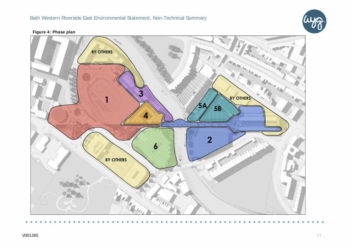
4.2.3 Access to the public transport system from the Proposed Development will be easy and will provide fast links within the city, including the current City Centre, as well as the outlying areas.
4.2.4 The assessment concludes that the Site is currently readily accessible by foot, cycle and public transport, and that the Proposed Development will substantially improve the pedestrian environment both within the Site and on routes to the Site, along with providing improvements in cycle and public transport facilities serving the Site.
4.2.5 Road safety is paramount in all scenarios. However in order to classify and assess the effects of the Proposed Development, the 5 year road collision history has been examined by location to identify any areas where traffic sensitivity is particularly high. For example areas which have experienced fatal accidents in the past. Two such locations are identified, along with other locations with lower sensitivity, and the effect of the Proposed Development has been assessed by reviewing the predicted change in peak hour volume of traffic at each location, compared to the existing volume of traffic. In all locations where road safety is of medium, high or very high sensitivity, the change in volume of traffic due to the Proposed Development is assessed as negligible.
4.2.6 The peak hour traffic capacity at the Pines Way Gyratory and the A36 / Windsor Bridge Road junction has been assessed for the ‘future’ without the Proposed Development, and the ‘future’ with the Proposed Development. Although both junctions are predicted to be busy in the ‘future’ without the Proposed Development and the Proposed Development is predicted to increase traffic at the junctions, the effect of the Proposed Development is predicted to be a slight worsening, but with no substantial increases in queue length or delay during the peak hours.
Figure 7: Local public transport link
V001265 16
Bath Western Riverside East Environmental Statement, Non-Technical Summary .
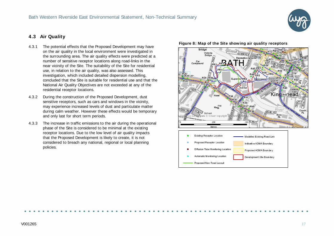
4.3 Air Quality
4.3.1 The potential effects that the Proposed Development may have on the air quality in the local environment were investigated in the surrounding area. The air quality effects were predicted at a number of sensitive receptor locations along road-links in the near vicinity of the Site. The suitability of the Site for residential use, in relation to the air quality, was also assessed. This investigation, which included detailed dispersion modelling, concluded that the Site is suitable for residential use and that the National Air Quality Objectives are not exceeded at any of the residential receptor locations.
4.3.2 During the construction of the Proposed Development, dust sensitive receptors, such as cars and windows in the vicinity, may experience increased levels of dust and particulate matter during calm weather. However these effects would be temporary and only last for short term periods.
4.3.3 The increase in traffic emissions to the air during the operational phase of the Site is considered to be minimal at the existing receptor locations. Due to the low level of air quality impacts that the Proposed Development is likely to create, it is not considered to breach any national, regional or local planning policies.
Figure 8: Map of the Site showing air quality receptors
V001265 17

Bath Western Riverside East Environmental Statement, Non-Technical Summary .
4.4 Noise and Vibration
4.4.1 The noise effects associated with the Proposed Development are assessed at sensitive receptors which include residential dwellings. During construction there is the likelihood that noise from specific works will be audible at the nearest receptors to the Site, although the noise will be temporary and decrease on completion of the construction. For large periods of the construction phase, works will occur well within the site boundaries and noise levels from construction works at receptor locations will be reduced or inaudible. Through standard mitigation measures implemented by the Contractor and enforced through suitably worded planning conditions, noise and vibration levels will not be significant for the duration of the works.
4.4.2 During the operational phase, potential noise generating sources include building services plant, deliveries, car parking, the petrol filling station and road traffic noise. The assessment undertaken addresses noise from these sources and demonstrates that noise from the commercial aspects will at acceptable levels within the context of baseline noise levels and relevant guidance documents. Where detailed noise information is not available at this stage, such as for building services plant, an assessment has been undertaken to demonstrate the control measures which can be easily implemented rendering the impacts insignificant. With regard to road traffic, an assessment has been undertaken with regard to the change in traffic flow on the internal road network within the site boundary and off-site roads. The change in noise level at all off-site residential properties will generally be barely, if at all, noticeable. However, in terms of the change in road traffic noise, noticeable reductions in noise have been predicted at properties located off Norfolk Crescent and Norfolk Buildings to the north of the site.
4.4.3 In addition to the noise investigations carried out during this EIA on the Site, it has been concluded that no operational vibration impacts will occur.
Figure 9: A diagram of the Site showing the existing daytime noise
V001265 18

Bath Western Riverside East Environmental Statement, Non-Technical Summary .
4.5 Light
4.5.1 The lighting effects of the Proposed Development are measured using sensitive receptors comprising of existing residential premises primarily located along the site boundary.
4.5.2 The nearest sensitive receptors are the residential dwellings located off Midland Bridge Road, Norfolk Crescent, dwellings within the new Crest Nicholson development to the west of the Site and Victoria Buildings along Lower Bristol Road (A36). Future residential receptors include the proposed residential dwellings located at Riverside Terrace, Queens Terrace, Midland Terrace and Norfolk Terrace. Bats that use the River Avon are also sensitive receptors.
4.5.3 During construction there is the likelihood that lighting from specific works will be noticeable at the nearest receptors to the Site although this will be temporary and for limited time periods. For large periods of the construction phase, as works occur well within the site boundaries, light from construction works at receptor locations will be reduced or unnoticeable. Through standard measures implemented by the Contractor and enforced through suitably worded planning conditions, lighting levels will be acceptable for the duration of the works.
4.5.4 During the operational phase, light sources include lighting associated with car parking, additional road lighting and amenity lighting throughout the new public realm. The current assessment has used a generic lighting scheme in the absence of full details of each development phase. The assessment undertaken addresses light from these sources and demonstrates that the schemes lighting is acceptable within the context of relevant guidance documents.
4.5.5 If there is a need for additional lighting, the use of appropriate mitigation measures, if required, such as shields, baffles and louvers is expected to address any adverse impact associated with light spillage or sky glow.
Figure 10: Lighting in the Proposed Development
V001265 19

Bath Western Riverside East Environmental Statement, Non-Technical Summary .
4.6 Ground and Groundwater
4.6.1 The historic and current uses for the BWR East Site have resulted in localised ground contamination being present within underlying soils. This ground contamination represents a possible risk to current and future end users, the adjacent River Avon and underlying groundwater as well as having the potential to create ground gases.
4.6.2 The Environment Agency has classified the geology that underlies the Site as a Secondary A Aquifer and the soils within the Site are recorded to be of a high leaching potential. Therefore, there is the potential for water and liquid contaminants to readily pass through the soil into the underlying geology, groundwater and subsequently into the adjacent River Avon. In addition, there is the potential for contaminants to migrate both onto and off site from neighbouring land.
4.6.3 A number of investigations have been previously conducted at the Site. A past report showed the presence of ground contamination including arsenic, copper, nickel and zinc within the made ground of the western section of the Site. In addition, an investigation of the adjacent site reported elevated concentrations of metals, phenols and hydrocarbons.
4.6.4 The investigations conducted on the Site have been partly limited by the fact that the area is situated in the Bath Hot Springs Protection Zone A. The area was designated as such by the County of Avon Act 1982. This has resulted in the maximum depth for excavations’ and drilling being limited to 5m without prior consent. Despite these limitations the samples collected during investigations on the Site have shown evidence of potential contamination. The contamination values discovered as a result of this investigation were compared to generic site screening values (SSV) for commercial and domestic purposes. A number of samples were found to contain contamination for a
number of substances including hydrocarbons, lead and arsenic which exceeded the SSV for both commercial and residential end use. In addition white asbestos was recorded across the Site and the limited gas monitoring undertaken at the Site showed elevated CO2 concentrations.
4.6.5 The potential effects of identified ground contamination on construction workers and groundwater during the construction phase are considered to be significant. In addition, the potential effects on third party properties and local area users during construction have also been considered. These potential impacts will be mitigated through the adoption of good site practices and compliance to statutory and regulatory guidance throughout the construction and operational phases. Specifically, the Principal Contractor will develop a ‘Construction Phase Plan’ containing details of a remediation strategy prior to the start of construction to limit the impacts of ground contamination. The Principal Contractor will also develop a plan to minimise and manage any waste material generated as a result of the construction activities.
4.6.6 The proposed remediation works will not only make the site suitable for the proposed development, it will also act to contain any remnant historic ground contamination, reducing the risk of any future ground contamination impacts to both the River Avon and the underlying aquifer.
V001265 20

Bath Western Riverside East Environmental Statement, Non-Technical Summary .
4.7 Hydrology and Flood Risk
4.7.1 The River Avon runs through Site. The risk of flooding has been considered in conjunction with the Environment Agency’s flood model. Recent changes to the river course, including river widening as part of the BWR development, has meant that the entire Site with the exception of the petrol filling station is above the flood plain. This means that all new buildings will not be at risk of flood damage. The petrol filling station is proposed to be redeveloped but it will remain at its original level and is therefore at some risk of flooding, but there will be flood prevention measures in place which will also decrease the risk of pollution during flood events.
4.7.2 To reduce the risk of flooding on the south side of the river, on the river bank will be set back by removing soil and therefore allowing more room for the River Avon when in high flow.
4.7.3 The Proposed Development will have the same impermeable area as the existing development on the Site, causing the same amount of surface water in storms. However, surface water runoff will be slowed down using underground tanks or other similar methods, thus reducing the rate of runoff into the River Avon and therefore decreasing flood risk. The surface water from the car parks will be cleaned using proprietary oil interceptor tanks to clean the flow prior to discharge to the river.
4.7.4 The overall effect of the Proposed Development will therefore be a small reduction in flood risk and a small improvement in water quality discharging to the River Avon.
Figure 11: Predicted 1 in 100 year flood areas
V001265 21

Bath Western Riverside East Environmental Statement, Non-Technical Summary .
4.8 Landscape, Townscape and Visual Impact Assessment
Likely landscape/townscape effects
4.8.1 The effects of the Proposed Development on the landscape resource are at their most significant during construction, with a significant adverse effect on overall Townscape Character; however, by nature, these effects are only temporary.
4.8.2 Once the construction phase is complete the effects on the individual elements of the landscape will be broadly neutral, with minor adverse effects on Cultural Heritage Assets and significant adverse effects on Vegetation being balanced by minor beneficial effects on Built Form and Land Use; and moderate beneficial effects on Access all contributing to a minor beneficial effect on overall Townscape Character.
4.8.3 Many of the positive aspects of the assessments on the physical landscape / townscape elements are assisted by the status of the existing landscape on the Site. The Site is largely declining, dominated by car parking and relatively poor quality buildings (with the exception of Green Park Station) and has difficult pedestrian access along a major desire line into the city. Currently the only truly positive aspects of the Site itself are the existing trees and the Green Park Station building. As a consequence of this poor quality landscape resource, the Proposed Development is able to generate positive benefits associated with many elements of the landscape. The only significant consequences of the development are the loss of significant numbers of mature trees, and some loss of perceived tranquillity along the river.
4.8.4 Overall the completed development will have an effect on townscape character. A small part of the City Centre and the Brassmill Lane, Locksbrook and Western Riverside Character Areas will be significantly changed by the development, however, once construction is completed this is a positive rather than a negative change. The area will change from one of general decline, with a landscape dominated by parking largely containing tired retail and industrial premises to one of modern residential / mixed use development. The overall effect is a minor beneficial one.
Figure 12: Artists Depiction of the Improved Bridge
V001265 22

Bath Western Riverside East Environmental Statement, Non-Technical Summary .
4.8.5 Taken cumulatively with the future Crest Site the positive aspects of the developments are exacerbated by the largely derelict nature of the Crest Site, and positive benefits associated with many elements of the landscape are easily obtained. Again only the loss of the mature trees on the Site and loss of perceived tranquillity detracts from the positive aspects of the combined developments. In this case the overall effect is assessed as a moderate beneficial one.
Likely visual effects
4.8.6 Given the size of the Proposed Development the area from which the buildings will be seen is small. In the countryside around Bath, views are restricted by topography and vegetation and few publicly accessible areas have views of the Site. In the urban area, views from both the public and private domain are constrained and restricted by topography; areas of mature vegetation; the orientation of streets and the nature of built form
(where the density of development and height of buildings prevents views). Views of the Proposed Development will be few from the public domain (particularly given the nature of the bowl in which Bath sits); and limited from private areas.
4.8.7 Almost inevitably, the construction phase generates the most significant visual effects, with some significant and substantial adverse effects experienced during this period. It is key to understand, however, that the construction phase effects are temporary in nature; and that assessments are made assuming the worst case scenario (the buildings are full height and covered in scaffolding). In reality, much of the construction phase will consist of periods when the buildings are lower or when elevations are completed and works are internal. Construction effects from each viewpoint will therefore be less significant than assessed for much of the construction period.
4.8.8 Once the scheme is operational, visual effects by day are moderate adverse at worst and two of the three viewpoints identified with this level of significance have only limited views of the development. All other adverse effects are slight adverse or less, and although effects from each viewpoint should be considered individually, for this development these adverse effects are, to some degree, balanced by some very-slight to slight beneficial effects experienced close to the Site where the proposals replace views of a declining landscape of poor quality, with views of a new, high quality urban area in keeping with the development to the west. Materials reflect elements of the traditional architecture of Bath, (although the architectural style places the scheme firmly in the 21st century) and buildings face positively onto the river and surrounding streets, creating a defined sense of place.
Figure 13: Green Park Station building (front)
V001265 23

Bath Western Riverside East Environmental Statement, Non-Technical Summary .
4.8.9 By night the most significant visual effects are from viewpoints in which the new foodstore atrium will form the most significant lit element in the scene. From viewpoints in which this is seen moderate adverse effects are experienced. As for day time, all other adverse effects are slight adverse or less, and these are balanced to some degree by very slight to slight beneficial effects experienced close to the Site.
4.8.10 Taken cumulatively with the adjoining Crest site, adverse visual effects on people at viewpoints within the surrounding countryside and viewpoints within the urban area on the upper slopes around Bath will increase slightly due to the overall size of this new urban quarter, however, none of these effects are significant. On the lower slopes within the built up area the Crest site development is unlikely to impact on some of the viewpoints identified for the Site, and for others there is no increase in the assessed significance of effect. From the viewpoints identified close to the Site, much of the development on the Crest site will not be appreciated, as this development will largely be screened from these viewpoints by the existing buildings on the Crest site or by the surrounding townscape. From the River Avon towpath, however, development to the west of the Victoria Bridge, and the part of the Crest scheme to the east of Victoria Bridge Road, will have an effect on the views along the river and will support the development on the Application Site. The combined developments will present a continuous, more coherent face along the south side of the river from Windsor Bridge (to the west) to Midland Bridge.
Figure 14: Arial view of Proposed Development
V001265 24

Bath Western Riverside East Environmental Statement, Non-Technical Summary .
4.9 Ecology
4.9.1 A desk study and Extended Phase 1 Habitat Survey was carried out which identified the potential for the Site to support a range of protected species. In addition to this, a number of designated wildlife sites are located in close proximity to the study area and these were therefore an important consideration in determining the additional surveys required. As a result the following surveys were carried out to inform this EIA:
• Badger Survey
• Otter and Water Vole Survey
• Bat Survey
4.9.2 None of the habitats within the Site, with the exception of the River Avon, were included within the UK or local Biodiversity Action Plan (BAP) as Priority habitats and on their own, the habitats are largely considered to be of limited ecological importance due to their small extent and isolated nature within an urban setting. The River Avon is important as a wildlife corridor.
4.9.3 No signs of otter, water vole or badger were recorded onsite. The bat surveys identified a number of trees offering low potential for small numbers of roosting bats and the River Avon was used by a number of common bat species for foraging and commuting. Further surveys will be completed in spring and summer 2013.
4.9.4 Mitigation within the design includes a number of enhancements to the Site for biodiversity, including incorporation of river terraces, sculptural bat towers and suitable landscaping. However in order to address and prevent potential impacts on sensitive receptors, a range of additional mitigation and enhancement measures have been proposed. To compensate for
the loss of trees across the Site, ten bat boxes and twenty bird boxes are proposed to be installed. These will provide roosting and nesting opportunities within the retained habitats on site. In addition, to prevent lighting impacts on foraging and commuting bats, a sensitive lighting scheme will be incorporated.
4.9.5 In order to ensure effective delivery of these measures, it is proposed that a detailed Ecological Management Plan will be developed in consultation with the relevant stakeholders prior to construction commencing. It is also recommended that a detailed management and maintenance regime is developed, in order to preserve the overall value of the Site in the long-term.
4.9.6 Overall, whilst there are limited features and species considered valuable to conservation on the Site, the Masterplan has been developed in order to minimise any negative impacts. Where the development has not been able to fully avoid these effects, additional mitigation measures have been proposed. The ES has found that once the construction and operational phase mitigation has been fully implemented, no residual negative impacts are considered likely to occur.
4.9.7 Positive impacts have been predicted for roosting bats, after completion of construction, due to the provision of two sculptural bat towers and bat boxes which will enhance roosting opportunities across the Site.
V001265 25

Bath Western Riverside East Environmental Statement, Non-Technical Summary .
4.10 Historic Environment
4.10.1 The proposed development is located within the complex historic landscape of Bath World Heritage Site. UNESCO awarded Bath this designation to recognise both the important Roman archaeology and the extensive 18th century designed cityscape. The Site lies within a Conservation Area containing both Grade I, II* and II Listed Buildings. The former station building, which is present on the Site, is also listed. The extent of the protection on the area means that the impacts any developments may have on; the landscape, historic buildings and immediate neighbours must be considered.
4.10.2 There is potential for any development to adversely affect the historic environment during and post construction. Construction may cause the destruction of archaeological deposits or damage to the historic station building. During construction there is potential for the development to affect the surrounding area through dust, noise and visual impacts. In addition there is the possibility that through inappropriate design, the landscape may be dominated by the new development and the historic townscape dramatically altered.
4.10.3 It is considered that the World Heritage Site will not be unduly affected by the development because this is an area that does not particularly exhibit the values used to represent Roman and 18th century Bath. For example, this area has a more workaday character that comes from offices, workshops and the station buildings themselves. Although the development is in the WHS, the area under consideration is not of the same significance as the historic core and while there are characteristic 18th century buildings, they are not found in the same density as they are elsewhere in the city.
Buried Archaeology
4.10.4 It is possible that construction would destroy buried archaeology. However, due to the distance of the Site from both the Roman settlement and the walled medieval town, this possibility is not considered significant. Historic maps show that the area was not developed until the 19th century, decreasing the likelihood of finding historically significant objects. It should also be noted that the construction of the railway and the buildings present on the Site now are likely to have removed anything of archaeological interest.
4.10.5 There will undoubtedly be an impact on the surrounds of the Site during the construction phase. However, this will be temporary and issues such as noise can be dealt with through management, works plans and considerate contractor agreements. Potential direct damage to the listed station buildings must be avoided, so it is proposed that protective measures and toolbox briefings to the workforce are employed to provide protection to the structure.
Figure 15: Historic map showing the extent of the railway on the Site
V001265 26

Bath Western Riverside East Environmental Statement, Non-Technical Summary
Townscape
4.10.6 The Site will alter the shape of the townscape. Nevertheless, good design, reflecting the character and scale of the townscape will ensure that the new development is, at least, not an intrusion. In addition, some aspects of the development will enhance the historic environment. These include the Stanier Bridge which will have the pedestrian bridge improved, and the station itself which will see the removal of car parking from beneath and around its canopy, allowing better understanding and appreciation of the structure, as well as more creative uses of its space.
Development Conclusions
4.10.7 Looking into Bath from the wider landscape, it is clear that the development has potential to cause significant change. However, the density of building in the city means that a well-designed development of appropriate height and materials will not stand out. The same is true of development close to heritage assets, such as Norfolk Terrace, where new building will alter, rather than damage the setting of the historic buildings through considered design and materials. Overall, the Site will not diminish the integrity of the World Heritage Site.
Figure 16: Artists impression view from the bridge following development completion
V001265 27

Bath Western Riverside East Environmental Statement, Non-Technical Summary
5.0 Summary
5.1 Conclusions
5.1.1 The ES has considered how the environment and the local community would be affected by the development.
5.1.2 A range of potential environmental effects have been predicted to occur as a result of the development, both positive and negative. However, mitigation measures have been identified, which will be secured by planning condition to appropriately reduce any adverse effects.
5.1.3 A small number of likely significant adverse effects have been identified in visual impact terms from some viewpoints into the site and in terms of impacts on the World Heritage Site. However, these are limited to the construction phase of the scheme and are therefore temporary in nature. Likely significant beneficial effects have been identified in terms of the socio-economic benefits that the development will bring to this part of Bath. All other identified impacts from the environmental assessments are not considered significant.
5.2 Management of Environmental Impacts
5.2.1 The impacts of the construction activities will be managed through a Construction Environmental Management Plan. This will ensure that working hours, traffic management, control of pollution, waste management, noise, dust and vibration are all managed and controlled.
5.2.2 A Landscape Statement has been produced which outlines the plans for landscaping and wildlife habitat creation, as well as proposals for the control of runoff from roads and hard surfaces, in order to reduce potential impacts on the local environment.
5.3 What happens next?
5.3.1 Prior to making a decision on the planning application, B&NES Council will seek advice from the Environment Agency, Natural England, English Heritage and other statutory and non-statutory consultees as part of the determination process for the submitted planning application.
5.3.2 The Council will make the full Environmental Statement available for examination by members of the public at the Council’s offices.
V001265 28


Printed copies of the non-technical summary and ES (including figures and appendices) may be obtained from:
Ropemaker Court, 11-12 Lower Park Row, Bristol, United Kingdom, BS15BN
Tel: +44 (0)117 925 4393
The non-technical summary is available free of charge, and a limited number of hard copies of the environmental statement are available for £350* per copy (plus p&p). Alternatively, these documents are available as adobe acrobat files on CD from the same address at £10 (plus p&p) per copy or can be downloaded from Sainsbury’s project website (www.sainsburys-bath.co.uk)
Copies of the ES may be also be viewed on BANES Council’s online services (http://www.bathnes.gov.uk/services/planning-and-building-control/view-and-comment-planning-applications) including via the self-service computers at The One Stop Shop, 3 - 4 Manvers Street, Bath, Riverside in Keynsham and The Hollies in Midsomer Norton.
* Includes VAT @15%
29