Bass Highway February 2020 - transport.tas.gov.au · Bass Highway – Wynyard to Marrawah Corridor...
76
Document title 1 February 2020 Bass Highway Wynyard to Marrawah Corridor Strategy
Transcript of Bass Highway February 2020 - transport.tas.gov.au · Bass Highway – Wynyard to Marrawah Corridor...

Document title 1
February 2020
Month/ Year
Month/ Year
Month/ Year
October 2019
Month/ Year
Month/ Year
Month/ Year
Bass Highway
Wynyard to Marrawah
Corridor Strategy

Bass Highway – Wynyard to Marrawah Corridor Strategy i
Contents
List of Figures ........................................................................................................................... iv
List of Tables ............................................................................................................................ iv
Glossary of Abbreviations and Terms...................................................................................... i
Executive Summary .................................................................................................................. 2
1. Introduction ..................................................................................................................... 4
1.1 What is a corridor strategy? ................................................................................................................... 4
1.2 Bass Highway – Wynyard to Marrawah ............................................................................................... 5
1.3 Vision for the future .................................................................................................................................. 6
1.4 Corridor objectives ................................................................................................................................... 7
1.5 Reference documents ............................................................................................................................... 7
2. Community Involvement ................................................................................................ 8
2.1 Consultation summary ............................................................................................................................. 8
2.2 Consultation with key stakeholders ...................................................................................................... 8
2.3 Community consultation .......................................................................................................................... 8
2.4 Key findings of consultation .................................................................................................................... 8
3. Existing Corridor Role and Demand ........................................................................... 10
3.1 Role and characteristics .........................................................................................................................10
3.2 Population and age demographic .........................................................................................................10
3.2.1 Population .................................................................................................................................................................... 10
3.2.2 Age demographic ....................................................................................................................................................... 10
3.3 Land use and zoning ................................................................................................................................11
3.4 Current traffic volumes and heavy vehicle use .................................................................................13
3.5 Industry and economic development ..................................................................................................16
3.6 Public transport and active transport .................................................................................................18
3.6.1 Public transport .......................................................................................................................................................... 18
3.6.2 Active transport ......................................................................................................................................................... 19
4. Current Corridor Performance ................................................................................... 20

Bass Highway – Wynyard to Marrawah Corridor Strategy ii
4.1 Road safety ............................................................................................................................................... 20
4.1.1 Existing crash data analysis ...................................................................................................................................... 20
4.1.2 Road safety hazard identification ........................................................................................................................... 25
4.2 Traffic performance ................................................................................................................................ 26
4.2.1 Corridor capacity ....................................................................................................................................................... 26
4.2.2 Overtaking opportunities......................................................................................................................................... 26
4.2.3 Pedestrians and cycling facilities ............................................................................................................................. 27
4.3 Road design and geometry ................................................................................................................... 28
4.3.1 Lane width and road shoulders .............................................................................................................................. 28
4.3.2 Horizontal and vertical geometry .......................................................................................................................... 28
4.3.3 Junctions ....................................................................................................................................................................... 29
4.4 Heavy vehicle rest areas ........................................................................................................................ 29
4.5 Road pavement condition ..................................................................................................................... 30
4.6 Environment and Heritage .................................................................................................................... 30
5. Future Corridor Changes and Transport Demand .................................................... 32
5.1 Population and economic growth ....................................................................................................... 32
5.2 Industry and economic development ................................................................................................. 34
5.2.1 Tourism ........................................................................................................................................................................ 34
5.2.2 Future freight task and heavy vehicle volumes ................................................................................................... 35
5.3 Traffic growth .......................................................................................................................................... 36
5.3.1 General traffic growth .............................................................................................................................................. 36
5.3.2 Future public transport and active transport demand ..................................................................................... 37
5.4 Safety .......................................................................................................................................................... 37
5.4.1 Cross section .............................................................................................................................................................. 37
5.4.2 Horizontal Geometry ............................................................................................................................................... 38
5.4.3 Vertical Geometry ..................................................................................................................................................... 38
5.4.4 Junctions ....................................................................................................................................................................... 39
5.4.5 Cyclists and pedestrians ........................................................................................................................................... 39
5.4.6 Surface condition ....................................................................................................................................................... 40
5.4.7 Recommended safety treatments .......................................................................................................................... 40
5.5 Travel time efficiency and reliability ................................................................................................... 41
5.5.1 Overtaking lanes ......................................................................................................................................................... 41
5.6 Resilience .................................................................................................................................................. 42
5.7 Alternative Routes .................................................................................................................................. 42
5.8 Climate change ........................................................................................................................................ 43
5.9 Support growth and social access ....................................................................................................... 44
Bass Highway – Wynyard to Marrawah Corridor Strategy iii
5.9.1 Corridor capacity ...................................................................................................................................................... 44
5.9.2 Provision of heavy vehicle rest areas ................................................................................................................... 44
5.9.3 Access to tourist attractions and facilities .......................................................................................................... 45
5.9.4 Public Transport ........................................................................................................................................................ 45
6. Corridor Challenges ...................................................................................................... 46
6.1 Corridor improvement targets ............................................................................................................46
6.2 Current corridor deficiencies and strategic response ....................................................................47
7. Bass Highway Corridor Priorities ................................................................................ 50
7.1 Corridor improvement prioritisation .................................................................................................50
7.2 Corridor strategy implementation plan .............................................................................................53
7.3 Strategy review .........................................................................................................................................60
Appendix A .............................................................................................................................. 61

Bass Highway – Wynyard to Marrawah Corridor Strategy iv
List of Figures
Figure 1.1 Corridor planning process .................................................................................................................................................... 4
Figure 1.2 Project location ........................................................................................................................................................................ 5
Figure 1.3 Corridor project site .............................................................................................................................................................. 6
Figure 2.1 Areas of concern are indicated by the orange areas, heat map from Social Pinpoint .......................................... 9
Figure 3.1 Population statistics for the Waratah-Wynyard and Circular Head municipalities .......................................... 11
Figure 3.2 Land Use Zoning and Study Corridor. .......................................................................................................................... 12
Figure 3.3 2017 AADT across the Bass Highway corridor with directional volumes of light and heavy vehicles ....... 14
Figure 3.4 2018 – 2019 max hourly two way traffic volume across the Bass Highway corridor .................................... 15
Figure 3.5 Statistics of key industry within the two municipalities ............................................................................................ 16
Figure 3.6 Monthly seasonal factor of two-way traffic volumes at each counter location along the Bass Highway .... 17
Figure 3.7 Summer and winter seasonal factors applied to two-way 2017 AADT ............................................................... 18
Figure 4.1 Location of crashes, January 2009 to March 2019 ..................................................................................................... 21
Figure 4.2 Crash type ............................................................................................................................................................................. 22
Figure 4.3 State Growth identified aboriginal heritage, historical heritage, and environmental community sites ......... 31
Figure 5.1 Historic and forecast population growth for Waratah-Wynyard and Circular Head municipalities ........... 32
Figure 5.2 Historic and forecast no. of people who travel to work by car across the two municipalities .................... 34
Figure 5.3 Potential Detention River to Black River Bypass Route ............................................................................................ 43
Figure 7.1 Corridor Implementation Plan – Wynyard to Myalla Road ...................................................................................... 54
Figure 7.2 Corridor Implementation Plan – Montumana Road to Speedwell Road ............................................................... 55
Figure 7.3 Corridor Implementation Plan – Port Latta to Old Stanley Road .......................................................................... 56
Figure 7.4 Corridor Implementation Plan – Brooks Road to Schuurings Road ...................................................................... 57
Figure 7.5 Corridor Implementation Plan – Christmas Hills Road to Rennison Road .......................................................... 58
Figure 7.6 Corridor Implementation Plan – Rennison Road to Marrawah ............................................................................... 59
List of Tables
Table 3.1 Summary of Population (ABS, 2001 to 2016) .............................................................................. 10
Table 3.2 2017 AADT along the Bass Highway ............................................................................................. 13
Table 4.1 Contributing factors for crashes ..................................................................................................... 23
Table 4.2 Casualty crash contributing factors, January 2009 to March 2019 ......................................... 24
Table 4.3 Road safety hazard identification .................................................................................................... 25
Table 4.4 Existing corridor capacity ................................................................................................................ 26
Table 5.1 Bass Highway Forecasts (AADT) ................................................................................................... 36

Bass Highway – Wynyard to Marrawah Corridor Strategy v
Table 5.2 Crash modification for various safety treatments ...................................................................... 41
Table 5.3 Existing corridor capacity ............................................................................................................... 44
Table 6.6.1 Corridor improvement targets .................................................................................................. 46
Table 6.2 Corridor deficiencies and mitigations ........................................................................................... 47
Table 7.1 Target improvements ........................................................................................................................ 50

Bass Highway – Wynyard to Marrawah Corridor Strategy i
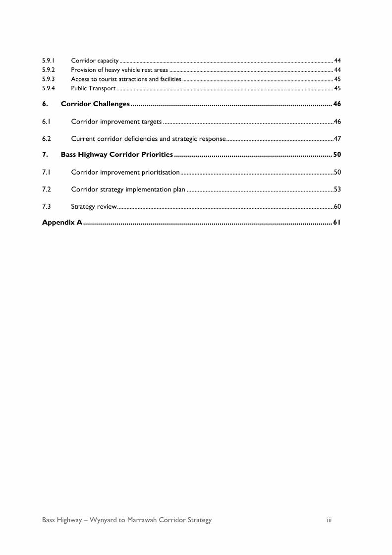
Glossary of Abbreviations and Terms
Term Description/Definition
AADT Annual Average Daily Traffic
Active transport The movement of people by walking or cycling
ABS Australian Bureau of Statistics
BAR Basic right-turn treatment
CHR Channelized right-turn treatment
CHR(s) Channelized short right-turn treatment
Cross section A vertical section, generally at right angles to the centreline showing the
ground and/or the road to be constructed.
Design speed A speed fixed for the design that determines the geometric features of a
road that influence vehicle operating speed.
Horizontal alignment The bringing together of the straights and curves in the plan view of a
carriageway
HVRA Heavy Vehicle Rest Area
ILM Investment Logic Mapping
LGA Local Government Areas
NLTN National Land Transport Network
Operating speed The speed over a section of road adopted by a driver as influenced by
the road geometry and other environmental factors
Road carriageway That portion of a road devoted particularly to the use of vehicles,
inclusive of shoulders and auxiliary lanes.
State Growth Department of State Growth
SISD Safe Intersection Sight Distance
Social Pinpoint An online engagement tool that uses interactive mapping to collect
feedback from members of the public
Vertical alignment Refers to a change in grade moving along the road (for example, up and
down a hill)
vpd Vehicles per day
vph Vehicles per hour

Bass Highway – Wynyard to Marrawah Corridor Strategy 2
Executive Summary
In 2018, the Tasmanian Government committed $40 million to upgrade the 110 km section of the Bass Highway
west of Wynyard to Marrawah. The Australian Government committed $60 million under the Roads of Strategic
Importance (ROSI) initiative.
The Bass Highway between Wynyard and Marrawah is the key link for freight, tourism and people movement
between the far north west of Tasmania and the key ports of Burnie and Devonport and further to Launceston
and Hobart.
The Department of State Growth (State Growth) has developed this corridor strategy with the primary objective
of developing a prioritised list of corridor improvement projects to meet the expected strategic function of the
road corridor over the next 20 years. It identifies the vision for the corridor and broad infrastructure initiatives
to improve road user safety, reliability and efficiency.
In April 2019, the Department of State Growth established the Bass Highway – Wynyard to Marrawah Corridor
Strategy Working Group. The purpose of the Working Group was to work together with the Tasmanian
Government to provide input and information on the issues affecting the Bass Highway between Wynyard and
Marrawah, assist in the development of the strategy and to set project priorities.
The working group included representatives from Waratah-Wynyard and Circular Head Councils, Cradle Coast
Authority, Tasmanian Transport Association, RACT and Department of State Growth. The Working Group
identified four key objectives for the corridor strategy to achieve future needs.
• Improve safety – for all road users, recognising the growing transport demands on the corridor
• Improve travel time reliability and efficiency – by providing an acceptable level of service for the
diverse group of road users (commuters, freight, tourists, and cyclists)
• Improve corridor resilience – by minimising delays caused by unplanned incidents
• Support growth and social access – improve economic support for the region by providing a good
quality transport corridor with reliable travel times.
This engagement, undertaken in conjunction with an engineering assessment of the road corridor and
consultation with the wider Tasmanian community, resulted in the identification of key issues and opportunities
for improvement of the Bass Highway corridor between Wynyard and Marrawah.
This strategy documents the approach and findings for arriving at the list of projects based on an assessment of
the existing road geometry, safety performance and transport efficiency, with the outcome being an identified list
of high, medium and low priority projects for delivery. It provides details of the stakeholder and community
consultation undertaken to develop the strategy to address current and future transport needs and prioritise
project delivery.
The vision for the Bass Highway between Wynyard and Marrawah over the next 20 years is to
provide a safe, reliable and consistent road for all road users that supports economic
development and future growth.

Bass Highway – Wynyard to Marrawah Corridor Strategy 3
Key characteristics of the highway identified through the review of available technical data, along with on-site
assessments include:
• the current traffic volumes of approximately 5000 vehicles per day between Wynyard and Smithton with
1000 or less vehicles per day west of Smithton
• heavy vehicle percentage is approximately 20% of all traffic
• sections of the highway are the appropriate standard for vehicle volumes and types
• there are overtaking lanes between Wynyard and Detention River
• the current road cross section is not adequate for current usage in some locations
• there are approximately 50 reported crashes per year across the corridor, most are off-road type
crashes (62% of all crashes) and rear end crashes (10% of all crashes)
• the existing road alignment has some inconsistencies including sub-standard curves
• some junctions require safety improvements
• signage and delineation in some sections is sub-standard
• sections of the highway have pavement with signs of distress or deterioration from traffic wear and tear.
Project upgrades identified include new overtaking lanes, junction upgrades, alignment improvements, and
shoulder widening. Priorities identified include:
• four new overtaking lanes
• 10 sections of road to be realigned, with potential for realigning an additional five sections
• 15 junction upgrades with potential for upgrading an additional 51 junctions
• Up to 60 km of shoulder widening with 25 km identified as a high priority.
When developing the project program, consideration was given to available and possible future funding
opportunities. A range of high and medium priority projects are expected to be delivered over the next five
years, based on funding committed by the Australian and Tasmanian Governments. Project delivery will also
depend on the availability of resources, projects requiring more immediate action, and unforeseen project
constraints. The planning of potential works will also consider if multiple projects can be combined to maximise
the financial investment and efficiency of delivery.
Implementing these projects will improve road safety, assist economic benefits and contribute to an increase
productivity by providing a more efficient corridor in the north-west region of Tasmania.

Bass Highway – Wynyard to Marrawah Corridor Strategy 4
1. Introduction
1.1 What is a corridor strategy?
The Department of State Growth (State Growth) has been progressively preparing corridor strategies for State
roads across Tasmania to create consistency in how the State Road Network is planned and managed.
Corridor strategies make planning and investment decisions transparent to the community, councils and other
community stakeholders. By reviewing a variety of elements as shown in Figure 1.1, the corridor strategy
identifies:
• corridor specific objectives that support the Tasmanian Government Building Your Future plans
• objectives to improve and encourage better transport and economic opportunities in the north of
Tasmania as identified in the State Road Upgrades – North West and West Coast Plan
• the performance of transport infrastructure in meeting the corridor specific objectives
• current and future challenges in meeting these corridor specific objectives
• key transport demands likely to be placed on the corridor over the next 10 – 20 years
• high, medium and low priorities and actions to improve the corridor.
The process for developing the strategy is shown below.
Corridor Strategy - Identifies short, medium and long term
investment priorities that contribute to the objectives
Identify corridor challenges in view of current performance and future needs
Identify future changes and impacts on the corridor
Assess the performance of the current corridor against targets
Stakeholder and community consultation used to identify the current transport demand, deficiencies and the role of
the corridor
Establish corridor vision and objectives
Define Corridor
Figure 1.1 Corridor planning process
Bass Highway – Wynyard to Marrawah Corridor Strategy 5
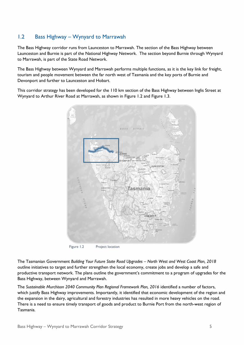
1.2 Bass Highway – Wynyard to Marrawah
The Bass Highway corridor runs from Launceston to Marrawah. The section of the Bass Highway between
Launceston and Burnie is part of the National Highway Network. The section beyond Burnie through Wynyard
to Marrawah, is part of the State Road Network.
The Bass Highway between Wynyard and Marrawah performs multiple functions, as it is the key link for freight,
tourism and people movement between the far north west of Tasmania and the key ports of Burnie and
Devonport and further to Launceston and Hobart.
This corridor strategy has been developed for the 110 km section of the Bass Highway between Inglis Street at
Wynyard to Arthur River Road at Marrawah, as shown in Figure 1.2 and Figure 1.3.
The Tasmanian Government Building Your Future State Road Upgrades – North West and West Coast Plan, 2018
outline initiatives to target and further strengthen the local economy, create jobs and develop a safe and
productive transport network. The plans outline the government’s commitment to a program of upgrades for the
Bass Highway, between Wynyard and Marrawah.
The Sustainable Murchison 2040 Community Plan Regional Framework Plan, 2016 identified a number of factors,
which justify Bass Highway improvements. Importantly, it identified that economic development of the region and
the expansion in the dairy, agricultural and forestry industries has resulted in more heavy vehicles on the road.
There is a need to ensure timely transport of goods and product to Burnie Port from the north-west region of
Tasmania.
Figure 1.2 Project location

Bass Highway – Wynyard to Marrawah Corridor Strategy 6
The Tasmanian Integrated Freight Strategy, 2016, details the importance of the highway as a principal freight route
for the movement of produce from the north and north west of Tasmania to key ports for the export of produce
to the rest of the world.
The existing highway between Wynyard and Marrawah is a single carriageway rural road of varying standard.
While some sections meet performance and design standards, others have been assessed as being substandard in
relation to cross section, geometric alignment and surface condition. There are also numerous intersections that
do not meet contemporary standards relating to the provision of safe turning facilities. This corridor strategy
draws on community needs and stakeholder feedback, assessments of the highway’s road conditions, traffic and
safety to determine its current level of performance. It also considers the current and future population needs,
economic development and proposed future land use.
1.3 Vision for the future
In 2018, the Tasmanian Government set out its policy commitments in Building Your future and the State Road
Upgrade commitments for Tasmania. A key commitment in these policies is building Tasmania’s infrastructure for
the 21st century. The vision for the Bass Highway between Wynyard and Marrawah over the next 20 years is to
provide a safe, reliable and consistent road for all road users that supports economic development into the
future.
The vision would specifically:
• provide a safe, efficient and consistent travel experience for all road users with improved road cross
section alignment and junction upgrades
• support productivity of agricultural and industrial activity to enable safe and reliable access for high
productivity vehicles from the north west to key ports in the north of Tasmania, as a principal freight
route
Figure 1.3 Corridor project site

Bass Highway – Wynyard to Marrawah Corridor Strategy 7
• have a sufficient number of overtaking opportunities in both directions to maintain a safe and efficient
level of service
• enhance road safety outcomes for all road users over the length of the corridor through implementation
of the safe system approach in the planning, development and delivery of improvement and maintenance
works.
1.4 Corridor objectives
In April 2019 State Growth established the Bass Highway – Wynyard to Marrawah Corridor Strategy Working
Group. The purpose of the Working Group was to work together with the Tasmanian Government to share
information, provide input and information on the issues affecting the Bass Highway between Wynyard and
Marrawah, develop the strategy and agree on the priorities for improvement.
The Working Group identified four key objectives for the corridor strategy to address to meet future needs.
Through Investment Logic Mapping (ILM) workshops, the Working Group assisted State Growth in developing an
understanding of the current issues which impact on the performance of the corridor and would benefit from
investment. They assisted State Growth in identifying sections which require treatment to achieve better
outcomes for all road users in the area.
The Working Group identified four major corridor objectives, the strategic intervention required, solutions that
would best respond to the problems identified, and the benefits that the program could achieve. The information
received during the community consultation period also reflected the issues raised by the Working Group.
The specific corridor objectives developed by the Working Group are in line with the Tasmanian Government
Building Your Future and State Road Upgrades – North West and West Coast commitments. The objectives are listed
below:
• Improve safety – for all road users, recognising the growing transport demands on the corridor
• Improve travel time reliability and efficiency – by providing an acceptable level of service for the
diverse group of road users (commuters, freight, tourists, and cyclists)
• Improve corridor resilience – by minimise delays caused by unplanned incidents
• Support growth and social access – improve economic support for the region by providing a good
quality transport corridor with reliable travel times.
1.5 Reference documents
The Corridor Strategy was developed with consideration of:
Department of State Growth Technical Specifications
Austroads Guide to Road Design
Austroads Guide to Road Transport Planning
Austroads Guide to Traffic Management

Bass Highway – Wynyard to Marrawah Corridor Strategy 8
2. Community Involvement
2.1 Consultation summary
The Tasmanian Government is committed to engaging with local communities and providing opportunities for
feedback throughout the development of all corridor strategies.
State Growth consulted with the community and key stakeholders during the development of this corridor
strategy to seek comment, feedback, ideas and suggestions to be considered alongside the engineering and road
design requirements.
This corridor strategy has been developed following consultation with the Working Group and the community.
The road user experience, as described by the community and stakeholders, has informed the process of
identifying current demand usage and experience and assisted in identifying the priority improvements. The
approach used in this corridor strategy is to make the most effective use of the existing and limited road space to
improve the safety, efficiency and quality of the road journey by all road users.
A summary of the consultation that was undertaken and the responses received are detailed in the Bass Highway –
Wynyard to Marrawah Corridor Strategy Consultation & Feedback Report (September, 2019).
2.2 Consultation with key stakeholders
State Growth held an initial meeting in Wynyard on 25 March 2019 with representatives from Circular Head
Council, Cradle Coast Authority and Waratah-Wynyard Council to discuss the development of the corridor
strategy and implementation plan.
In April 2019, the Bass Highway - Wynyard to Marrawah Corridor Strategy Working Group was established to
share information, provide input and information on the issues affecting the Bass Highway between Wynyard and
Marrawah and to assist in the development of the strategy and agree on project priorities. The Working Group
comprised of representatives from Waratah-Wynyard and Circular Head Councils, the Cradle Coast Authority,
Tasmanian Transport Association, RACT and the Department of State Growth.
The Working Group informed the corridor strategy objectives, as outlined in Section 1.4 and provided input
during the identification of potential improvements within the corridor and the prioritisation of those
improvement projects.
2.3 Community consultation
Community consultation was undertaken between 13 May 2019 and 7 June 2019, with feedback collected via
Social Pinpoint, feedback forms (available from the Circular Head Council and Waratah-Wynyard Council offices),
on the State Transport website and Facebook page, as well as local social media sites.
Feedback was sought to better inform the strategy document and was important in developing the corridor
strategy to ensure local knowledge would be utilised in future upgrade and maintenance activities. The feedback
helped to ensure that the planned investment on the highway will meet the needs of the local communities and
industries it serves.
2.4 Key findings of consultation
There are different types of road users sharing this part of the road network who have different trip purposes
and use the road network at different times. They include motorists and passengers of private cars, bus and coach
users, hire cars, recreational vehicles, motorcyclists, cyclists, pedestrians, small commercial vehicles and a variety

Bass Highway – Wynyard to Marrawah Corridor Strategy 9
of freight and heavy vehicles. The feedback received from the stakeholders and community stressed the
importance of future-proofing the corridor to support business and tourism growth as well as local access, by
having a standard of highway suitable for a mix of heavy vehicles, cars, cyclists and pedestrians.
A total of 239 pieces of feedback/comment were received during the community consultation phase.
Safety, reliability and efficiency improvements were identified as key issues through the consultation period,
including the following specific issues:
• road and shoulder widening
• junction improvements
• road alignment and sight-line improvements
• line marking and signage
• hazards such as overgrown vegetation, lighting and drainage
• provision of overtaking opportunities
• provision of cycling infrastructure
• safety issues relating to the mix of heavy vehicles and other vehicles on narrow sections of the highway.
The feedback received and specific issues raised are outlined in more detail in the Bass Highway – Wynyard to
Marrawah Corridor Strategy Consultation & Feedback Report (September, 2019). The issues raised were similar to the
issues identified by the Working Group.
The key areas of concern resulting from the consultation process are shown in Figure 2.1.
Figure 2.1 Areas of concern are indicated by the orange areas, heat map from Social Pinpoint
Boat Harbour Rocky Cape
Smithton
Brittons Swamp
Togari Wynyard
Marrawah
Port Latta
Bass Highway – Wynyard to Marrawah Corridor Strategy 10
3. Existing Corridor Role and Demand
3.1 Role and characteristics
Between Wynyard and Marrawah, the Bass Highway performs multiple functions, as it is the key link for freight,
tourism and commuters between the far north west of Tasmania and the rest of the state. As such, the highway
not only carries heavy vehicles it also provides residential and tourist access and contributes to Australia’s export
markets, particularly in the agricultural and tourism sectors.
The Bass Highway’s transport roles reflect the population and communities that it passes through which include:
• Supporting travel to and from the region by:
- Connecting towns from the far north west of Tasmania to Wynyard and beyond
- Providing a freight link between the far north west of Tasmania and the National Highway.
• Supporting travel within the region by:
- Linking smaller towns to employment, education and services in the larger towns and centres
- Serving as a route for business, tourism and leisure travel.
• Supporting travel to major centres and towns by:
- Providing tourism and local business access to towns such as Smithton, Stanley and Boat Harbour
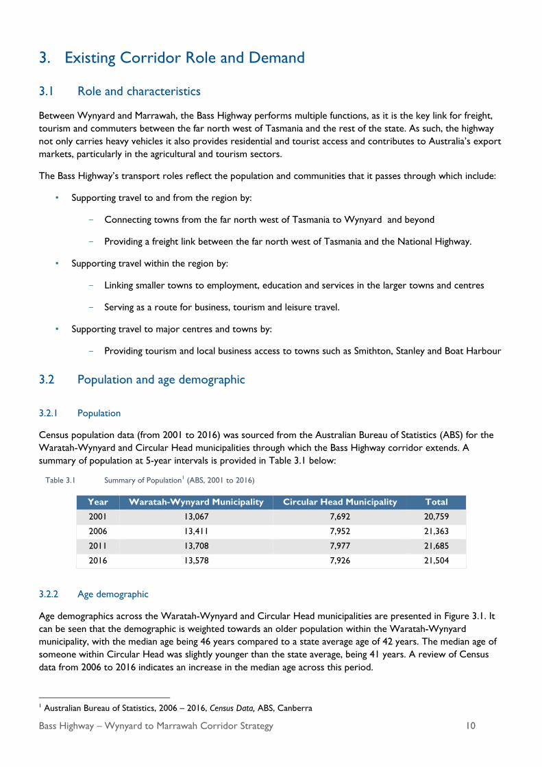
3.2 Population and age demographic
3.2.1 Population
Census population data (from 2001 to 2016) was sourced from the Australian Bureau of Statistics (ABS) for the
Waratah-Wynyard and Circular Head municipalities through which the Bass Highway corridor extends. A
summary of population at 5-year intervals is provided in Table 3.1 below:
Table 3.1 Summary of Population1 (ABS, 2001 to 2016)
Year Waratah-Wynyard Municipality Circular Head Municipality Total
2001 13,067 7,692 20,759
2006 13,411 7,952 21,363
2011 13,708 7,977 21,685
2016 13,578 7,926 21,504
3.2.2 Age demographic
Age demographics across the Waratah-Wynyard and Circular Head municipalities are presented in Figure 3.1. It
can be seen that the demographic is weighted towards an older population within the Waratah-Wynyard
municipality, with the median age being 46 years compared to a state average age of 42 years. The median age of
someone within Circular Head was slightly younger than the state average, being 41 years. A review of Census
data from 2006 to 2016 indicates an increase in the median age across this period.
1 Australian Bureau of Statistics, 2006 – 2016, Census Data, ABS, Canberra

Bass Highway – Wynyard to Marrawah Corridor Strategy 11
Figure 3.1 Population statistics for the Waratah-Wynyard and Circular Head municipalities2
3.3 Land use and zoning
The corridor extends west from the Wynyard township along the north-west coast of Tasmania through to
Smithton, then south-west to the west coast settlement of Marrawah. Land use and zoning along the highway,
along with geographical description, is described in sections as follows (see also Figure 3.2):
• Between the residential settlements of Wynyard and Boat Harbour the highway traverses rolling basaltic
soils that are extensively used for intensive agricultural production.
• The highway corridor then climbs in a westward direction from the rolling coastal plateau near Boat
Harbour to pass over Sisters Hills and falls to the coastal plains near Rocky Cape through land that
remains predominately rural resource in use.
• The coastal plain fronting Bass Strait is narrow until west of Rocky Cape where it becomes more
expansive passing over Detention River and through the Dip Range Regional Reserve. Through this
section, the land is predominately rural resource in use.
• Along the coast the highway passes near to the small coastal settlements of Hellyer and Crayfish Creek
continuing along the coast through Little Peggs State Reserve and Conservation Area and Black River
Crossing. Through this section, the land to the east of the highway is predominately used as a rural
resource. The land to the west of the highway, is used for low density residential, environmental
management, general industrial, utilities and open space.
• The highway runs north west through Wiltshire to Smithton. Through Wiltshire, the land is
predominately used as a rural resource while through Smithton, land is used for light industrial,
commercial, general industrial, general residential, rural resource, rural living, and environmental
management.
• The highway then runs south of the Smithton township through to the settlement of Marrawah used both
for agricultural and forestry as well as the Bond Tier Regional Reserve.
2 Australian Bureau of Statistics, 2006 – 2016, Census Data, ABS, Canberra

Bass Highway – Wynyard to Marrawah Corridor Strategy 12
3
3 Tasmanian Government, 2019, The LISTmap, www.thelist.tas.gov.au
Figure 3.2 Land Use Zoning and Study Corridor.

Bass Highway – Wynyard to Marrawah Corridor Strategy 13
Remnant vegetation exists on coastal ranges and along major watercourses and is in relatively intact tracts. South
of Smithton there are large tracts of forestry land interspersed with rural land and the Dip Range Regional
Reserve.
The underlying productive soils have resulted in extensive clearing for agriculture where the terrain is more
forgiving. Major industrial activity has been concentrated around the larger townships of Wynyard and Smithton
where historically rail transportation was used to transport timber, mining and agricultural goods for export to
mainland Australia.
3.4 Current traffic volumes and heavy vehicle use
The Annual Average Daily Traffic (AADT) along the Bass Highway was recorded in 2017 at a number of locations
between Marrawah and Wynyard. The surveys show two-way traffic volumes range from around 285 vehicles per
day (vpd) in Marrawah in the far western extent of the corridor up to 4,968 vpd at Preolenna Road at Flowerdale,
near the eastern extent. This is consistent with population density which increases towards the coastal population
centres of Wynyard, Burnie and Devonport.
Table 3.2 2017 AADT along the Bass Highway
AADT (vpd) %HV Volume (vpd)
Arthur River Road, Marrawah 285 18%
Rennsion Road, Togari 567 22%
Mella Road, Broadmeadows 916 29%
Nelson St (west), Smithton 1,376 21%
Nelson St (east) Smithton 2,581 27%
Brittons Rd, Smithton 4,674 16%
Irishtown Rd, Smithton 3,658 18%
Cowrie Point Rd, Cowrie
Point
2,692 22%
Port Road, Boat Harbor 4,635 23%
Preolenna Road, Flowerdale 4,986 15%
Inglis Street, Wynyard 3,466 20%
Figure 3.3 illustrates the AADT volumes of both light and heavy vehicles split by direction at each of the traffic
counter locations on Bass Highway. The percentage of heavy vehicles averaged at approximately 21%. There is a
higher percentage of heavy vehicles in Broadmeadows, Smithton and Boat Harbour, and where agriculture and
industry movements use the Bass Highway as the major arterial connection.

Bass Highway – Wynyard to Marrawah Corridor Strategy 14
Figure 3.3 2017 AADT across the Bass Highway corridor with directional volumes of light and heavy vehicles4
4 The Department of State Growth, 2017, Permanent Traffic Counters, Unpublished

Bass Highway – Wynyard to Marrawah Corridor Strategy 15
Figure 3.4 2018 – 2019 max hourly two way traffic volume across the Bass Highway corridor 5
5 The Department of State Growth, 2018 – 2019, Permanent Traffic Counters, Unpublished

Bass Highway – Wynyard to Marrawah Corridor Strategy 16
3.5 Industry and economic development
The dominant key industries that operate within the two municipalities are agriculture, forestry and fishing,
manufacturing and construction, as shown in Figure 3.5.
Bass Highway performs a key arterial freight route function, connecting local industries to major population
centres (including Burnie, Devonport, Launceston and Hobart) as well as key ports in Stanley and Burnie.
The current major industries that contribute most significantly to vehicle movements (including heavy vehicles) on
the Bass Highway are the following:
• Forestry
• Mining
• Agriculture management (e.g. gravel and equipment transport)
• Agriculture produce transport (e.g. live cattle (beef), vegetable and dairy)
• Fishing.
Figure 3.5 Statistics of key industry within the two municipalities6
6 Australian Bureau of Statistics 2016, Census Data, ABS, Canberra

Bass Highway – Wynyard to Marrawah Corridor Strategy 17
Tourism is another major industry which contributes to economic activity within the north-west region of
Tasmania. The volume of tourism related traffic is seasonal in nature, peaking during the summer months, and has
been estimated by assessing the seasonal factors of recorded traffic volumes and identifying the difference
between peak (summer) and off-peak (winter) traffic flows, which are plotted in Figure 3.6.
The traffic volumes vary approximately 10-15% from the average daily traffic on the Bass Highway and this
variation could be considered seasonal and related to tourism and increased agricultural production. During the
summer months, tourism related traffic is estimated to range from 60 to 100 vpd at the western end of the
corridor near Marrawah, to a range of 1,000 to 2,000 vpd at the eastern end of the corridor near Wynyard, as
shown in Figure 3.7.
Figure 3.6 Monthly seasonal factor of two-way traffic volumes at each counter location along the Bass Highway7
7 The Department of State Growth, 2017, Permanent Traffic Counters, Unpublished
Bass Highway heading west to Smithton Port Latta Pellet Plant and Port Facility

Bass Highway – Wynyard to Marrawah Corridor Strategy 18
Figure 3.7 Summer and winter seasonal factors applied to two-way 2017 AADT8
3.6 Public transport and active transport
3.6.1 Public transport
While the dominant means of transport on the Bass
Highway corridor is private vehicle, there are public
transport options.
Public bus services
Public transport between towns and smaller
communities is limited, due to the small population
size. One public bus operator provides a limited public
bus service along the corridor between Wynyard and
Smithton. Operating Monday to Friday, they provide:
• One general access morning service from
Smithton to Burnie (one-way), departing at
7:00 AM on school days and 8:15 AM during
school holidays, and arriving at 8:35 AM and
9:50 AM respectively.
• One afternoon trip from Burnie to Smithton (one-way), departing at 2:45 PM and arriving at 4:30 PM.
8 The Department of State Growth, 2017, Permanent Traffic Counters, Unpublished
Seasonal tourism traffic
Public transport near Rocky Cape

Bass Highway – Wynyard to Marrawah Corridor Strategy 19
As part of the Tasmanian Government’s bus service review, from April 2020, public bus services will increase to
seven days a week operation, including on public holidays. There will be one inward trip and one outward trip
each day between Smithton and Burnie.
School bus routes
Many of the towns are serviced by school bus operators
and provide services for both students within the towns
and for students in the rural areas between towns.
Coaches
Coach services are provided along the corridor by
several providers for a variety of customer needs.
Taxis and peer-to-peer ride sharing
Taxis operate in most towns along the Bass Highway
corridor, with limited services and fleet sizes.
Limited peer-to-peer ride sharing services are available
from Wynyard.
3.6.2 Active transport
Pedestrian and cycling facilities
The Bass Highway corridor does not serve as a regular cycling route between towns. Dedicated infrastructure for
walking and cycling is restricted to urban centres, where there is a higher demand for such infrastructure.
One section of the highway has been identified as a
cyclist route. A cycling circuit starts at Wynyard and
continues along Table Cape Road to the Table Cape
lookout, then travels westward along Tollymore Road
to the Bass Highway, before returning to Wynyard
along the highway. The section of the Bass Highway
that is included in this route, currently has a sealed
shoulder width of 1 m or less.
There is little demand for pedestrian facilities between
towns due to distance.
Table Cape lookout / Tollymore Road junction
School warning signage heading east along
Bass Highway in Boat Harbour

Bass Highway – Wynyard to Marrawah Corridor Strategy 20
4. Current Corridor Performance
This chapter reviews the Bass Highway’s current corridor
performance and condition.
4.1 Road safety
4.1.1 Existing crash data analysis
Crash data was obtained from State Growth for the Bass
Highway within the study area between January 2009 and
March 2019.
Number of crashes
A total of 458 crashes were recorded on Bass Highway during this period. Of these, a total of 220 resulted in a
casualty. There were 13 crashes resulting in fatality, 26 resulting in serious injury, 134 minor injury and 47
requiring first aid.
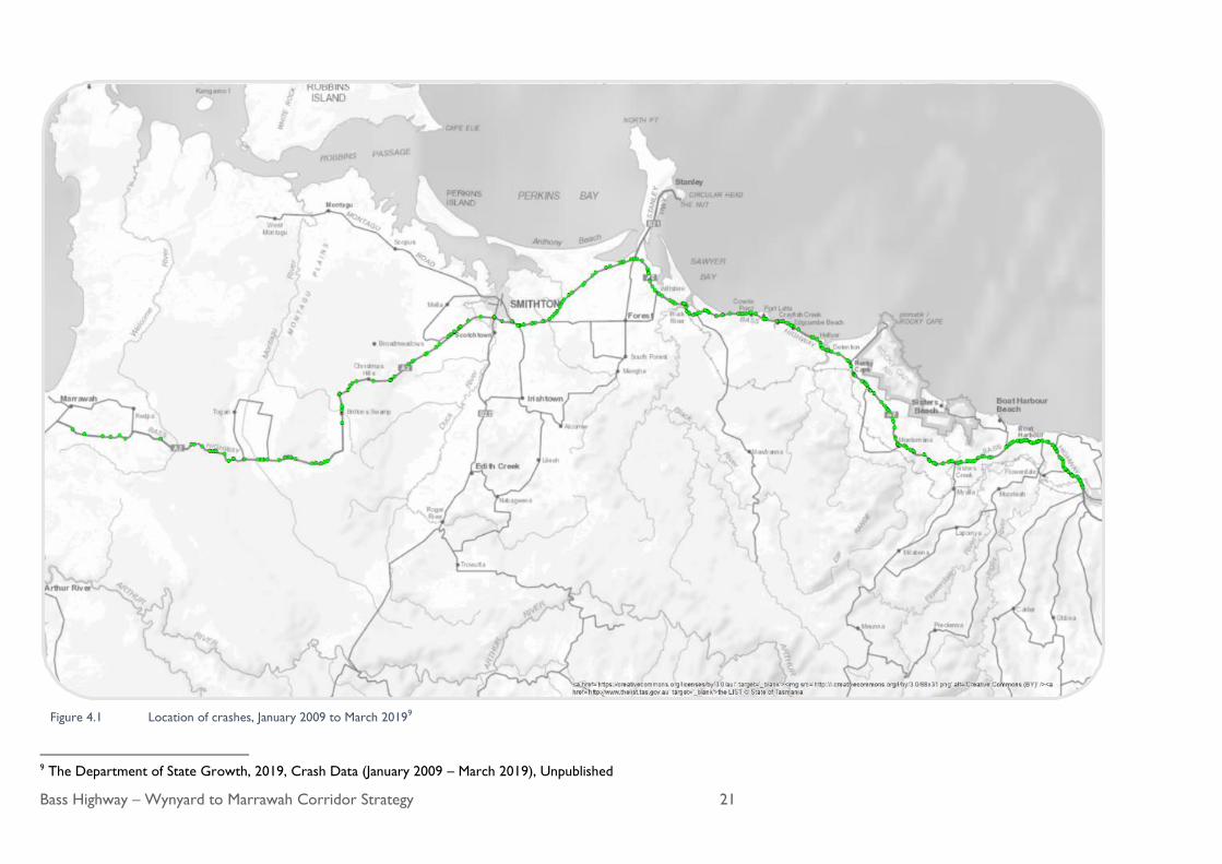
Figure 4.1 below shows the locations of the recorded crashes. While there are some specific locations with crash
histories, the figure indicates that there are safety concerns for the full length of the corridor. To assess this a
Road Safety Hazard Identification Assessment was undertaken (Section 4.1.2).
Oversize vehicle travelling east from Boat Harbour
Bass Highway – Wynyard to Marrawah Corridor Strategy 21
Figure 4.1 Location of crashes, January 2009 to March 20199
9 The Department of State Growth, 2019, Crash Data (January 2009 – March 2019), Unpublished

Bass Highway – Wynyard to Marrawah Corridor Strategy 22
Seasonal crash rates
Seasonal crash rates indicate an increased crash rate during the summer months higher compared with the
seasonal increase in traffic volumes. This indicates that other factors influence crash rates other than traffic
volumes.
Crash type
Figure 4.2 details the most prevalent crash types recorded on the Bass Highway during the 10 year period.
Figure 4.2 Crash type
The crash analysis undertaken indicates that the majority of incidents were the result of drivers losing control of
their vehicle and the vehicle leaving the carriageway (62% of all crashes). Rear-end collisions are also a prominent
crash type making up 10% of all crashes in the section in the last 10 years (Figure 4.2).
It should also be noted that during community engagement, anecdotal advice was received of numerous
unrecorded run off road property damage crashes.

Bass Highway – Wynyard to Marrawah Corridor Strategy 23
Contributing factors
Of the 458 recorded crashes, 51 involved heavy vehicles, 14 involved motorcycles and three (3) involved
pedestrians. Table 4.1 summarises the contributing factors recorded for all report crashes within the 10 year
period to March 2019.
Table 4.1 Contributing factors for crashes
Crash factor Number of crashes Percent of crashes
Vehicle involvement
Light vehicle crashes 390 85%
Heavy truck crashes 51 11%
Motorcycle 14 3%
Pedestrian 3 0%
Road surface conditions
Wet 230 50%
Dry 209 46%
Oil / Fuel 8 2%
Icy 5 1%
Unknown 6 1%
Natural lighting
Daylight 307 67%
Dawn / Dusk 28 6%
Darkness 121 26%
Unknown 2 1%
Weather
Clear 261 57%
Heavy rain 35 8%
Light rain 144 31%
Smoke, Snow or Fog 8 2%
Not known 10 2%

Bass Highway – Wynyard to Marrawah Corridor Strategy 24
Casualty Crashes – Contributing factors
Table 4.2 summaries the contributing factors recorded for all casualty crashes within the ten year period to
March 2019.
Table 4.2 Casualty crash contributing factors, January 2009 to March 2019
Casualty crash factor Number of casualty
crashes
Percent of casualty
crashes
Vehicle involvement
Light vehicles 181 82%
Heavy vehicles 24 11%
Motorcycle 11 5%
Pedestrian 4 2%
Number of vehicles involved
One-vehicle crash 167 76%
Two-vehicle crash 46 21%
Multi-vehicle crash (more
than two vehicles) 7 3%
Type of crash
Side swipe 3 1%
Object in travel lane 6 3%
Head on – not overtaking 17 8%
Rear end 15 7%
Pedestrian 4 2%
Overtaking 7 3%
Run off road – on straight 49 22%
Manoeuvring 4 2%
Intersection 6 3%
Run off road – on curve 109 49%
These crashes occurred in varying conditions, both day and night, wet and dry. The serious crashes showed
similar percentages of crash type, vehicle type and occurred in varying conditions.

Bass Highway – Wynyard to Marrawah Corridor Strategy 25
4.1.2 Road safety hazard identification
A road safety hazard identification assessment was undertaken to supplement the desktop assessment of the road
geometry.
Key findings are summarised in Table 4.3 below:
Table 4.3 Road safety hazard identification
Key findings
Road Geometry The default 100 km/h speed limit is not suitable for entire length of the corridor,
particularly on steep grades on curved sections
There are sight distance constraints at various locations across the corridor
Narrow or no shoulder width in some sections of the corridor
There are a high number of concealed accesses along the corridor
Intersections Some intersections have deficient Safe Intersection Sight Distance (SISD)
Many junctions have no turning facilities
Line marking, particularly reflective treatment is not clear or is missing at some junctions
There is insufficient signage at some intersections
Delineation and signposting Poor edge line and centreline delineation in some areas
Reflective pavement markers or signage have poor visibility in sections
Infrequent reflective guide posts and hazard warning / information signage in sections
Additional signage is necessary in some sections, particularly those with sub-standard
curves
Roadside hazards and safety
barriers
Improvements are required to safety barriers along the corridor including substandard end
terminals, inadequate approach and departure lengths
Clear zones are not achieving target levels
Improvements required to culvert end wall protection with non-driveable end walls, or
inappropriate roadside barriers
More safety barriers where necessary
Surface condition Improvement required in road quality (rough surface) in some sections
Drainage Improvements in road geometry and drainage is necessary in some sections
Wire rope barrier on a curve near Detention River W-beam barrier on a curve travelling north-west
from Wynyard

Bass Highway – Wynyard to Marrawah Corridor Strategy 26
4.2 Traffic performance
4.2.1 Corridor capacity
To assess the theoretical capacity of the Bass Highway – Wynyard to Marrawah corridor, the road has been
broken into three sections, where the cross section, heavy vehicle percentage and topography is relatively
consistent. The three sections are:
• Wynyard to Detention River where the existing road cross section is typically 3.5 m lanes and 1.0 m
sealed shoulders, 20% heavy vehicles and moderate topography
• Detention River to Smithton where the existing road cross section is typically 3.0 m lanes and up to
1.0 m sealed shoulders, 18% heavy vehicles and level topography
• Smithton to Marrawah where the existing road cross section is typically 3.0 m lanes with no sealed
shoulders, 23% heavy vehicles and level topography
A comparison of the theoretical capacities and the current demand is provided in Table 4.4 below, and indicates
that the existing corridor capacity is adequate for the current traffic volumes.
Table 4.4 Existing corridor capacity 10
Theoretical Capacity
(vph)
Existing Max Volume
(vph)
Wynyard to Detention River 970 430
Detention River to Smithton 1120 364
Smithton to Marrawah 820 77
4.2.2 Overtaking opportunities
While the highway has the theoretical capacity noted above, the actual efficiency and level of service is also
influenced by the ability for faster vehicles to pass slower vehicles. The existing highway corridor has a small
number of overtaking lanes and a number of areas where there is the opportunity to overtake slower vehicles.
An assessment was undertaken to determine whether the overtaking opportunity on a two way rural road is
adequate or whether the construction of dedicated overtaking lanes may be warranted.
The assessment takes into account the traffic volume, the percentage of heavy vehicles and the available
overtaking opportunity. Overtaking opportunity is defined as the percentage of road length in the preceding 5 to
10 kilometres that provides adequate sight distance for a vehicle to overtake.
The availability of overtaking opportunities is a key aspect of travel time reliability, which has a direct impact for
business and tourism planning, logistics and the associated costs.
The provision of overtaking lanes is determined by the following criteria:
where traffic volumes are greater than 4,330 vpd with 20% heavy vehicles, overtaking lanes should be
provided at 10 to 15 km maximum spacing
where traffic volumes are less than 1,130 vpd with 20% heavy vehicles, and there is some overtaking
opportunity, then overtaking lanes are not warranted
10 Austroads, 2017, Guide to Traffic Management Part 3, Traffic Studies and Analysis

Bass Highway – Wynyard to Marrawah Corridor Strategy 27
Using the existing traffic volumes and heavy vehicle percentages that are noted in Section 3.4, the requirement for
overtaking lanes on the Bass Highway – Wynyard to Marrawah would be as follows:
• Wynyard to Smithton – 5,000 vpd with 20% heavy vehicles. Overtaking lanes are currently warranted
at 10 to 15 km maximum spacing.
• Smithton to Mella Road – 1,000 vpd with 20% heavy vehicles and there is adequate overtaking
opportunity for current traffic. No overtaking lanes are currently warranted.
• Mella Road to Marrawah – 600 vpd with 20% heavy vehicles and there is adequate overtaking
opportunity for current traffic. No overtaking lanes are currently warranted.
There are overtaking opportunities and lanes between Wynyard and Smithton, however, the number provided is
not considered to be adequate for the volume of traffic and percentage of heavy vehicles travelling on this section.
The traffic volumes and percentage of heavy vehicles using the highway west of Smithton does not currently
require the installation of overtaking lanes.
4.2.3 Pedestrians and cycling facilities
The Bass Highway corridor is a typical two lane rural road environment with no dedicated pedestrian or cycling
facilities.
Cyclists
Between towns, there is currently no dedicated off road cycling infrastructure. The majority of the Bass Highway
has sealed shoulders less than the recommended minimum sealed width.
Pedestrians
Demand for pedestrian facilities is low, with some local movements around coastal settlements. There are
currently no dedicated crossing facilities along the corridor, and movement along the roadside is generally within
the road shoulder or verge.
Westbound overtaking lane near Montumana Eastbound overtaking lane near Rocky Cape

Bass Highway – Wynyard to Marrawah Corridor Strategy 28
4.3 Road design and geometry
Data on the existing road geometry has been collected and reviewed against contemporary standards.
A summary of the information collected is discussed below.
4.3.1 Lane width and road shoulders
The Bass Highway between Wynyard and Marrawah has varying existing road cross sections (lane and shoulder
width) dimensions. The nominal existing road cross sections are summarised as follows:
• Wynyard to Detention River – Two traffic lanes of between 3.1 m to 3.5 m width with 0.6 m to 1.0
m wide shoulders
• Detention River to Smithton – Two traffic lanes of approximately 3.0 m width with 0.0 m to 0.6 m
wide shoulders
• Smithton to Marrawah – Two traffic lanes of approximately 3.0 m with no shoulders.
4.3.2 Horizontal and vertical geometry
Curves in the roadway can be described as horizontal or vertical. A horizontal curve is a bend in the road which
veers to the left or right, whereas a vertical curve is a change in grade, either up or down (such as driving up and
down a hill). The curve radius measures the size or tightness of a curve.
Horizontal and vertical geometry is influenced by the adjacent topography. Along the length of the Bass Highway
corridor the topography varies from flat pasture land through to undulating forested sections.
The safety of a curve depends on the vehicle operating speed, super elevation (angle of the rise or fall of the
slope) and friction of the roadway surface.
One important consideration in assessing the curve radius is the sight distance provided when considered with
the design speed. Motorists need to be able to navigate through curves efficiently and assess any potential danger
on the roadway with enough time to avoid an incident.
Typical alignment near Togari Typical alignment near Mella Rd
Bass Highway – Wynyard to Marrawah Corridor Strategy 29
The analysis of the existing highway indicates that in numerous locations, the horizontal and vertical alignments
are inconsistent with the current operating speed. These locations do not currently provide an adequate
transition of design speed between adjacent elements to be able to safely drive at the posted speed limit.
There are eight locations where the curves (or series of curves) have advisory speed signs. The advisory sign
recommends speeds ranging from 25 km/h to 65 km/h.
In relation to the stopping sight distance, there are 60 locations between Wynyard and Smithton, and 44 locations
between Smithton and Marrawah that require improvements, due to the vertical curves of the existing road.
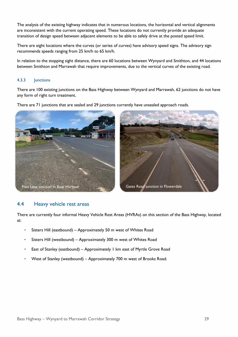
4.3.3 Junctions
There are 100 existing junctions on the Bass Highway between Wynyard and Marrawah, 62 junctions do not have
any form of right turn treatment.
There are 71 junctions that are sealed and 29 junctions currently have unsealed approach roads.
4.4 Heavy vehicle rest areas
There are currently four informal Heavy Vehicle Rest Areas (HVRAs) on this section of the Bass Highway, located
at:
• Sisters Hill (eastbound) – Approximately 50 m west of Whites Road
• Sisters Hill (westbound) – Approximately 300 m west of Whites Road
• East of Stanley (eastbound) – Approximately 1 km east of Myrtle Grove Road
• West of Stanley (westbound) – Approximately 700 m west of Brooks Road.
Fists Lane junction in Boat Harbour Gates Road junction in Flowerdale

Bass Highway – Wynyard to Marrawah Corridor Strategy 30
4.5 Road pavement condition
Roads deteriorate over time due to the effects of traffic volumes, type, weather and underlying environmental
conditions. Timely road maintenance prevents defects from escalating into larger problems.
The condition of the existing pavement is monitored and managed by State Growth. Should the pavement
condition fall below the required quality, remediation works are undertaken.
4.6 Environment and Heritage
The Bass Highway corridor is a rich source of biodiversity, cultural heritage and agricultural production. Through
the length of the corridor, there are areas of threatened flora and fauna communities and species, and a number
of Aboriginal places and heritage sites identified. A preliminary desktop assessment review of the corridor
identified environmental issues which would need to be taken into account when considering the individual
upgrade projects.
The location of known heritage and environmental features that may impact on corridor upgrade works have
been mapped and are identified in Figure 4.3 below.
Prior to any works being undertaken all projects would have to undergo the appropriate environmental and
heritage assessment. Appropriate assessment of soil and water bodies would also be required.

Bass Highway – Wynyard to Marrawah Corridor Strategy 31
Figure 4.3 State Growth identified aboriginal heritage, historical heritage, and environmental community sites

Bass Highway – Wynyard to Marrawah Corridor Strategy 32
5. Future Corridor Changes and Transport Demand
5.1 Population and economic growth
Historical population statistics sourced from the Australian Bureau of Statistics (ABS) for the Waratah-Wynyard
and Circular Head municipalities provided context for population growth trends. Between 2001 and 2016, the
population across both Local Government Areas (LGA) increased from 20,759 to 21,504 representing an increase
by around 745 people or 0.24% per annum.
Based on historic population growth trends, the population in the Waratah-Wynyard municipality is forecast to
reach approximately 14,800 people by the year 2050 with a growth rate of 0.27%, and in the Circular Head
municipality the population is forecast to reach approximately 8,500 people with a growth rate of 0.21%. This
growth in population is shown in Figure 5.1.
Figure 5.1 Historic and forecast population growth for Waratah-Wynyard and Circular Head municipalities11
11 Australian Bureau of Statistics, 2001 – 2016, Census Data, ABS, Canberra

Bass Highway – Wynyard to Marrawah Corridor Strategy 33
Both Waratah-Wynyard Council and Circular Head Council have identified the impact of demand on future
service delivery and utilisation of assets in their Strategic Asset Management Plans for 2015 – 2025. These include
the following:
• Both Councils have identified an aging population, with the proportion of residents over 60 years of age
expected to increase. This transition is expected to increase the usage of footpaths so there is a demand
to widen footpaths and satisfy compliance with the Disability Discrimination Act 1992.
• Waratah-Wynyard Council has identified that over the next 10 years the population is expected to
increase at a rate of 0.25% per annum12. This expectation is in line with historic trends. Since this
population growth trend is relatively low it is not expected to significantly impact the demand for service
delivery.
• Circular Head Council has identified that over the next 5 to 10 years the population in the municipality is
expected to experience a slight decline13. Growth rates based on historic population data forecasts
positive growth at 0.21% per annum. Circular Head Council has advised State Growth, that they aim to
grow the population in the municipality to 10,000 by 204014. This suggests a growth rate of approximately
0.6% per annum, however this strategy is yet to be outlined by council.
• Projections of journey to work mode share is likely to maintain dominance in car usage across both
municipalities. Based on historical data the average rate which journeys to work by car is expected grow
is 0.23% per annum between the two municipalities. The historical and forecast data is shown in Figure
5.2.
• Historic growth trends of other journey to work methods do not suggest a significant mode shift from
cars. Therefore it is considered that population growth in the region will directly influence growth in
traffic volumes.
12 Waratah-Wynyard Council, July 2015, Strategic Asset Management Plan, Available at:
https://www.warwyn.tas.gov.au/webdata/resources/files/WWC%20SAMP%20V1.2%20-%20July%202015%20wwc.pdf, Accessed 1/11/2019 13 Circular Head Council, January 2018, Strategic Asset Management Plan, Available at:
https://www.circularhead.tas.gov.au/webdata/resources/files/CHC%20SAMP%20V1%200.pdf, Accessed 1/11/2019
14 Circular Head Council, 10 May 2019, Personal Communication, Benji Krom

Bass Highway – Wynyard to Marrawah Corridor Strategy 34
Figure 5.2 Historic and forecast no. of people who travel to work by car across the two municipalities15
5.2 Industry and economic development
5.2.1 Tourism
The Tasmanian Visitor Economy Strategy 2015-2020 envisages achieving a target of 1.5 million annual visitors across
the whole of Tasmania by 2020. Recent data published by Tourism Tasmania indicates that there were a total of
1.32 million visitors to Tasmania for the 12 months to December 2018, with 529,000 of those visiting the Cradle
Coast region (including the Waratah-Wynyard and Circular Head municipalities). The year-on-year growth rate is
approximately 4%.
The Sustainable Murchison 2040 Community Plan Regional Framework Plan, 2016 recognises that the north west area
is well-developed with a range of tourist destinations which are aspiring to receive growing numbers of national
and international visitors by 2040. The natural environment is a key asset in promoting tourism, with attractions
such as Cradle Mountain, further east. There is a vision of holding more events with autumn and winter marketing
campaigns to expand the visitor season from summer.
With the Waratah-Wynyard and Circular Head municipalities accounting for a sizeable proportion of the
Murchison electorate there is reasonable basis to expect tourist traffic to increase in the region by 2040.
15 Australian Bureau of Statistics, 2001 – 2016, Census Data, ABS, Canberra

Bass Highway – Wynyard to Marrawah Corridor Strategy 35
5.2.2 Future freight task and heavy vehicle volumes
Circular Head Council has advised State Growth, that they are expecting growth in some of their larger
industries due to several planned upgrades and new proposals.16 These have been described below.
• There is potential for an increase in potato processing capability of the McCain facility in Smithton.
• There have been recent increases in the production capacity of the Britton Timbers mill in Smithton.
• The Dutch Mill (Australia) Pty Ltd milk processing plant at Edith Creek is expected to be re-established.
• The development of 1,200+ megawatts of wind farm infrastructure over two sites in Jim’s Plain and
Robbins Island by UPC Renewables.
• Potential increases in dairy productions from the area due to the construction of new dairies in the area.
Across the two municipalities there is a projection that there would be an increase in windfarm infrastructure,
agriculture, construction, forestry, milling, and processing industries. Therefore, there is an expectation that
freight and transport tasks with heavy vehicle movements will increase at a rate slightly higher than the historic
growth rates along the Bass Highway.
16 Circular Head Council, 2019, Personal Communication, 10 May
The Nut at Stanley Tarkine Adventures at Dismal Swamp
Anticipated increase in windfarm infrastructure in
north west Tasmania Heavy vehicle traffic heading west, near Sisters Creek

Bass Highway – Wynyard to Marrawah Corridor Strategy 36
5.3 Traffic growth
5.3.1 General traffic growth
Traffic growth along the Bass Highway corridor between Marrawah and Wynyard has been estimated using a
combination of the following:
• Historic growth trends
- AADT growth rates were provided by State Growth at each of the 15 selected counter locations
along the Bass Highway corridor17. These indicate that Bass Highway has grown at a rate of
around 0.5% to 1.0% p.a. towards the western end of the corridor (Marrawah) and 1.5% p.a.
towards the eastern end of the corridor (Boat Harbour and Wynyard)18.
• Population and demographics
- There is an expected increase in car use of around 1.6% p.a. for Circular Head and 1.7% p.a. for
Waratah Wynyard based on population growth and journey to work method trends. This is
nominally in line with historic traffic growth trends.19
• Industry
- Section 5.2.2 identifies a range of upgrades and new proposals to be developed throughout the
region which is likely to result in freight and heavy vehicle traffic growth rates which are slightly
higher than historic growth trends.20
• Tourism
- Section 5.2 identifies a current year-on-year growth rate in visitation to the Cradle Coast region
of approximately 4% p.a. It is expected that this growth will continue in the short to medium-
term.21
Based on the above, forecasts for Bass Highway are provided in Table 5.1.
Table 5.1 Bass Highway Forecasts (AADT)
Approximate Location 2020 2040 2050
Total HV % Total HV % Total HV %
West of Smithton (Mella Road, Broadmeadows) 954 29% 1209 30% 1336 30%
Smithton (Brittons Road) 4840 16% 5942 17% 6493 17%
Boat Harbour 4866 22% 6396 22% 7162 21%
West of Wynyard (Inglis Street) 3638 20% 4791 19% 5367 19%
17 The Department of State Growth, 2017, Permanent Traffic Counters, Unpublished 18 Linear growth rates have been expressed as a percentage of 2017 traffic volumes 19 Australian Bureau of Statistics, 2001 – 2016, Census Data, ABS, Canberra 20 Circular Head Council, 2019, Personal Communication, 10 May 21 Tourism Industry, Tasmanian Government, 2015, The Tasmanian Visitor Economy Strategy 2015-2020, Available at
https://www.t21.net.au/__data/assets/pdf_file/0004/37723/T21-Strategy-web.pdf, Accessed 18/11/2019

Bass Highway – Wynyard to Marrawah Corridor Strategy 37
Given the corridor also needs to cater for seasonal variations, the following volumes have been adopted to set
geometric and performance targets for the 20 year timeframe (2040):
• Wynyard to Smithton – 7000 vpd (a total 20 year growth of 40%).
• Smithton to Mella Road – 1200 vpd (a total 20 year growth of 20%).
• Mella Road to Marrawah – 1000 vpd (a total 20 year growth of over 20%).
5.3.2 Future public transport and active transport demand
Public transport
Public transport only accounts for a very low percentage of people travelling along the Bass Highway corridor.
State Growth will be implementing improved services into the future, and this may increase patronage. It is not
expected that this will have a significant impact on overall vehicle volumes or vehicle composition.
Active transport – Cyclists
While the Wynyard to Marrawah corridor is not frequently used by cyclists, it is a fundamental safety issue to not
provide cyclists with an alternative to riding in the traffic lane with high speed vehicles. Provision of wider
shoulders is likely to increase usage of the highway by cyclists, but it is not considered that this corridor will
become a major cycling route in the short to medium term.
Active transport – Pedestrian facilities
Demand for pedestrian facilities is low, with some local movements around community centres. There are
currently no dedicated crossing facilities along the corridor, and movement along the roadside is generally within
the road shoulder or verge. As local communities grow, the demand for dedicated pedestrian facilities will need
to be reassessed.
5.4 Safety
5.4.1 Cross section
The standard and frequency of treatments for single carriageway rural roads is based primarily on traffic volumes.
The proposed road cross section has been determined using the 2040 traffic volumes and consistency with the
existing road environment.
The following cross-sections would be adopted.
Wynyard to Smithton - 7000 vehicles per day (More than 3000 vehicles per day)
• The standard is for lane widths of 3.5 m with sealed shoulder of 1.5 m
To provide consistency with the State Road Network, adopt 3.5 m lanes and 1.0 m sealed shoulder. This cross
section also provides consistency with recently upgraded sections of the highway.
Smithton to Mella Road – 1200 vehicles per day (1000 – 3000 vehicles per day)
• The standard is for lane widths of 3.5 m with sealed shoulder of 1.0 m
Adopt 3.5 m lanes and 1.0 m sealed shoulder.
Mella Road to Marrawah – up to 1000 vehicles per day (less than 1000 vehicles per day)
• The standard is for lane widths of 3.1 m with 0.5 m sealed shoulder.

Bass Highway – Wynyard to Marrawah Corridor Strategy 38
For consistency with the State Road Network adopt 3.0 m lanes and 1.0 m sealed shoulder – this shoulder width
also provides an area for cyclists.
Target Cross Section
• Wynyard to Smithton – 3.5 m lanes and 1.0 m sealed shoulder
• Smithton to Mella Road – 3.5 m lanes and 1.0 m sealed shoulder
• Mella Road to Marrawah – 3.0 m lanes and 1.0 m sealed shoulder.
5.4.2 Horizontal Geometry
As noted in Section 4.3.2, there are a significant number of curves on the existing highway that do not meet
current design requirements for a design speed of 110 km/h. While lower design speeds reduce the highway
efficiency, it is not a major safety issue provided the road elements transition down adequately to provide an
appropriate speed environment. Unfortunately, there are also a number of locations where the highway does not
transition adequately and this increases the likelihood of off-road type crashes. Some of these locations do not
have adequate warning signs or delineation.
Therefore it is recommended that horizontal alignment improvements are undertaken, to provide a consistent
and predictable travel speed along the highway. The specific treatment at each location is to be determined with
reference to the required cost and benefits achieved. Where practical, the alignment should be upgraded to the
preferred design speed of 110 km/h. Where this is not practical, the alignment should be adequately transitioned
into the lower speed environments. Proposed road alignment improvements would be determined by reviewing
predicted travel speeds against the existing alignment. This would require removal of inconsistent road geometry.
In particular, low speed curves adjacent to high speed sections of the highway.
In the short term, where inconsistent alignments exist, adequate warning signage and delineation should be
installed.
Target
The specific treatment at each location is to be determined with reference to the required cost and benefits
achieved. Treatments are to be determined from the following:
• Realign the horizontal geometry to meet the operating speed of the highway
• Ensure adequate warning signage and delineation at all sub-standard curves that are not to be realigned.
5.4.3 Vertical Geometry
As noted in Section 4.3.2 there are a number of locations where the existing vertical alignment is not adequate to
meet the required stopping sight distance. Stopping sight distance is an important safety element that should be
provided, if possible. Therefore, it is recommended that where practical, locations with sub-standard stopping
sight distance be regraded to provide the required stopping sight distance. Where this is not practical, adequate
warning signs should be provided.
There are some locations where the vertical alignment obstructs the view of approaching vehicles. These are
particularly unsafe locations that may lead to drivers choosing to overtake when not safe to do so. These
locations should be prioritised for regrading.
While some sag curves do not meet the documented comfort criteria, regrading of the highway at these locations
is not considered a priority unless being undertaken as part of a broader project.

Bass Highway – Wynyard to Marrawah Corridor Strategy 39
Target
• Regrade the existing highway in locations where sub-standard vertical curves contribute to crash history
• Regrade the highway in locations where approaching cars are obscured by the vertical alignment
• Provide crest warning signage at all sub-standard locations as required.
5.4.4 Junctions
As noted in Section 4.3.3, the majority of junctions between Wynyard and Marrawah do not meet contemporary
standards for safety treatments. It is proposed that all junctions are assessed to identify the improvements
required and upgraded to meet minimum standard requirements.
There are also many junctions where the adjoining roads are unsealed through to the edge of the highway. All
junctions should be sealed.
Some junction geometry does not allow easy turning manoeuvres for the type of vehicle using the junction.
Vehicle types using each junction should be reviewed (where the information is available) and the appropriate
design vehicle used to determine junction geometry.
Target
• All junctions are to be reviewed and upgraded to meet contemporary safety standard
• All unsealed public junction areas to be sealed
• Provision of appropriate signage to all major destinations and tourist facilities
• All junctions should be reviewed for the appropriate design vehicle and vehicle turning paths and
upgraded where required.
5.4.5 Cyclists and pedestrians
Any road design project must consider the needs of all relevant road users including cyclists, pedestrians and
other non-motorised traffic of all age groups.
Cyclists and pedestrians are particularly vulnerable road users. Design for such users will seek to facilitate their
movements by separating them from motor vehicles. This may be on the road carriageway, by providing available
space on the carriageway, or on roadside facilities such as footpaths and shared use paths.
Port Road junction near Boat Harbour Arthur River Road junction near Marrawah

Bass Highway – Wynyard to Marrawah Corridor Strategy 40
In 2013, the State Government developed a policy for cycling infrastructure in Tasmania – the Positive Provision
Policy for Cycling Infrastructure Mainstreaming the Provision of Cycling Facilities as Part of Transport Projects and
Maintenance of Cycling Space. The Positive Provision Policy requires that consideration will be given to make
provision for cycling on routes identified on Regional Arterial Cycling Networks.
While the Wynyard to Marrawah corridor is not part of the NW Coastal Pathways Plan, the eastbound side of
the Bass Highway, east of Tollymore Road, is included in State Growth’s State wide High Use Cycling Routes
mapping. Therefore, the intent of the Positive Provision Policy should be adopted for this section of the highway.
For the remainder of the corridor, it is considered a minimum treatment to provide a 1.0 m wide sealed shoulder
outside the traffic lane is considered a practical compromise between providing a cycling facility and cost. While a
wider shoulder would be preferred, it is a significant improvement on areas that currently have no sealed
shoulder.
When designing upgrade works as part of the corridor, it is recommended that each location further considers
the warrants for provision of a wider shoulder for cyclists.
Target
• Provide appropriate shoulder width for eastbound side of the Bass Highway, east of Tollymore Road to
Wynyard.
• Provide a minimum 1 m wide sealed shoulder for the full length of the corridor.
• Warrant for wider shoulder or dedicated cycling facilities to be considered as part of all upgrade works.
• Warrant for dedicated pedestrian facilities to be considered as part of all upgrade works.
5.4.6 Surface condition
As noted in Section 4.5, responsibility for the road surface condition rests with State Growth. However, when
works are to be undertaken as part of this corridor strategy, the maintenance works program should be
monitored. This is to ensure that there is no duplication of works in both programs and also to allow works to be
undertaken concurrently if this is advantageous.
That is, where remediation works under the maintenance program are required in locations where works under
the corridor strategy is also required, there may be benefits combining the works to minimise overall cost and
impact on the community.
5.4.7 Recommended safety treatments
Road features can play a key role in reducing the occurrence of run-off-road crashes. These features include, but
are not limited to, the geometry of curves, edge of pavement drops, shoulder treatments, poor delineation and
insufficient passing opportunities. Excessive speed, particularly on bends is also noted as a contributory driver
factor for run-off-road crashes, as well as driver inattention and overtaking. In relation to safety treatments and
their expected effectiveness in reducing loss of control crashes, the following measures (Table 5.2) are rated
highest:

Bass Highway – Wynyard to Marrawah Corridor Strategy 41
Table 5.2 Crash modification for various safety treatments22
Safety Treatment Run off road – on straight Run off road – on curve
Off road Off road, hit
object
Off road Off road, hit
object
Installation of guard rail 30% 30% 30% 30%
Installation of wire rope safety barrier 85% 90% 85% 90%
Sealing shoulders 40% 40% 40% 40%
Edge lines 30% 30% 30% 30%
Reconstructed superelevation on curves 50% 50%
Advisory speed signs on curves 30% 30%
When considering reduction of rear end collisions, the most effective treatments would include adequate junction
treatments and advance directional signage.
5.5 Travel time efficiency and reliability
5.5.1 Overtaking lanes
With reference to Section 3.4, the existing traffic volumes and heavy vehicle percentages already warrant the
provision of additional overtaking lanes between Detention River and Smithton at 10 to 15 km maximum spacing.
Using the projected traffic growth figures for 2040 shown in Section 5.3, future overtaking lane warrants are
assessed as follows:
• Wynyard to Smithton – 7000 vehicles per day with 20% heavy vehicles - Overtaking lanes are
warranted at a maximum 10 – 15 km spacing.
• Smithton to Mella Road – 1200 vehicles per day with 20% heavy vehicles – There is adequate
overtaking opportunity for current and projected traffic.
• Smithton to Marrawah – 1000 vehicles per day with 20% heavy vehicles - There is adequate
overtaking opportunity for current and projected traffic.
As the volumes increase, the requirement for more frequent overtaking lanes also increases. Therefore it is
recommended that in the short term, the strategy includes the provision of overtaking lanes at maximum 10 to
15 km spacing between Detention River and Smithton. In the medium to long term it is expected that additional
22 Austroads, 2015, Guide to Road Safety Part 8 Treatment of Crash Locations
Advisory signage near Detention River Guard rail near Hellyer

Bass Highway – Wynyard to Marrawah Corridor Strategy 42
overtaking lanes will be required between Wynyard and Smithton. As traffic volumes grow, further demand for
overtaking lanes should be determined using traffic modelling software to assess the most beneficial locations.
Target
• Provision of additional overtaking lanes between Detention River and Smithton at 10 to 15 km maximum
spacing.
• Planning for additional overtaking lanes between Wynyard and Smithton.
5.6 Resilience
5.7 Alternative Routes
During the consultation process, a number of options for alternative highway routes were suggested for
investigation. Construction of duplicate road infrastructure requires significant capital investment and ongoing
maintenance costs. Therefore, justification for the construction of alternative routes would require that the
existing route does not meet community needs or that the new route would be able to provide significant
financial benefit.
The usual drivers for construction of an alternate highway route would be where the existing highway does not
meet the following requirements:
• Highway capacity – the existing infrastructure does not provide adequate capacity or cannot be upgraded.
• Connectivity – the existing infrastructure does not provide adequate access for all road users.
• Function – the existing infrastructure does not adequately cater for multiple functions.
• Amenity – the existing infrastructure has become a social issue either through noise or community
segregation.
• Efficiency – the new route could provide significant travel time and/or vehicle cost savings.
• Safety – the existing infrastructure is unsafe and cannot be adequately upgraded.
As discussed in previous sections, the existing highway either meets or is capable of being upgraded to meet all of
the above requirements for at least the next 20 years. One advantage of a duplicate route would be the provision
of alternative access. While this would be beneficial, it would also be very difficult to justify on economic grounds
given that closure of the existing highway is rare and when it does occur it is generally only for short periods of
Overtaking lane near Montumana
‘Overtaking lane ahead’ signage,
heading west from Wynyard

Bass Highway – Wynyard to Marrawah Corridor Strategy 43
time. Therefore, at least in the short to medium term, there is no identified need to construct alternate highway
routes.
5.8 Climate change
The Tasmanian Government has developed the Climate Change Action Plan 2017-21 and has commissioned a
number of research projects to understand and monitor the potential impacts of climate change on the state. The
expected impacts from climate change vary across Australia. The impacts include an increase in the frequency and
severity of weather events, increase in bushfires, sea level rise, coastal erosion, changing weather conditions such
as temperatures and rainfall patterns.
It is acknowledged that climate change effects have the potential to require mitigation works. It is recommended
that the mitigations be undertaken as required. Potential road impacts from climatic conditions will continue to be
monitored.
The 12 km section of the Bass Highway between Detention River and Black River has been identified as an area
that is potentially susceptible to climate change impact. A bypass of this area has been provisionally identified for
future consideration of an inland road realignment23. Figure 5.3 shows a potential bypass route.
23 Paul Arnold Consulting, 2015, Upgrade of the Bass Highway, Its vital link – Economic Importance and Strategic Road Significance
Smithton - Burnie
Legend
Existing Bass Highway
Proposed Bypass
Figure 5.3 Potential Detention River to Black River Bypass Route
Bass Highway

Bass Highway – Wynyard to Marrawah Corridor Strategy 44
5.9 Support growth and social access
5.9.1 Corridor capacity
The future road capacity for the Bass Highway has been assessed using the same methodology as discussed in
Section 4.2.1.
The future theoretical capacity of the highway is based on the proposed cross section noted in Section 5.4.1,
grade and heavy vehicle percentages similar to existing.
For the purpose of future capacity analysis, the existing highway has been broken into three sections, where the
cross section, heavy vehicle percentage and topography is relatively consistent as follows:
• Wynyard to Smithton where the proposed road cross section is 3.5 m lanes and 1.0 m sealed
shoulders, 19% heavy vehicles and moderate topography
• Smithton to Mella Road where the proposed road cross section is 3.5 m lanes and 1.0 m sealed
shoulders, 24% heavy vehicles and level topography
• Mella Road to Marrawah where the proposed road cross section is 3.0 m lanes and 1.0 m sealed
shoulders, 20% heavy vehicles and level topography
A comparison of the theoretical capacities and the predicted future demand is shown in Table 5.3 below. This
indicates that the proposed cross section would provide adequate capacity for the future traffic volumes.
Table 5.3 Existing corridor capacity 24
Theoretical Capacity
(vph)
Estimated Future Peak Hour Volume
(vph)
Wynyard to Smithton 990 528
Smithton to Mella Road 1250 153
Mella Road to Marrawah 1100 42
Between Wynyard and Smithton, the topography is moderate, while between Smithton and Marrawah, it is level.
The topography through Wynyard and Smithton, has reduced its theoretical capacity.
Between Smithton and Mella Road, and Mella Road and Marrawah, the topography and percentage of heavy
vehicles is similar. The reduced capacity between Mella Road and Marrawah, is due to the proposed cross section.
Target
The proposed future road cross sections are adequate to provide the theoretical capacity for the predicted 2040
volumes.
5.9.2 Provision of heavy vehicle rest areas
The demand for Heavy Vehicle Rest Areas (HVRAs) between Wynyard and Smithton is medium to high. It is
proposed that the existing informal rest areas shown below are retained, reviewed for increased capacity and
safety, and upgraded.
24 Austroads, 2017 Guide to Traffic Management Part 3, Traffic Studies and Analysis

Bass Highway – Wynyard to Marrawah Corridor Strategy 45
• West of Stanley (northbound)
• East of Stanley (southbound)
• Sisters Hill (eastbound)
• Sisters Hill (westbound)
In the medium term, as demand rises, the development of a Class 5 HVRAs approximately central between
Wynyard and Smithton should be considered.
The demand for HVRAs between Smithton and Marrawah is relatively low. Current predicted volumes would not
warrant the development of a formal rest area, however consideration should be given to providing an informal
rest area centrally located between Smithton and Marrawah for use on an ad hoc, as required basis.
Target
• Retain existing heavy vehicle rest areas and undertake capacity and safety improvements as required.
• Investigation for an informal heavy vehicle rest area in each direction centrally located between Smithton
and Marrawah.
• Investigation for Class 5 heavy vehicle rest area for each direction centrally located between Wynyard
and Smithton.
5.9.3 Access to tourist attractions and facilities
Provision of safe and efficient access to tourist attractions and facilities is a necessary part of the corridor targets.
The corridor should also provide adequate advance directional signage and advice for drivers unfamiliar with the
area to navigate easily to their destination. It is recommended that the corridor targets include upgrade of tourist
and rest area accesses to contemporary safety standards including installation of directional signage as required.
Target
• Provision of adequate advance directional signage to all tourist attractions and facilities.
5.9.4 Public Transport
Where adjacent to road upgrade projects, it is recommended that existing general access bus stops be upgraded
so they are compliant with DDA requirements.
Target
Where adjacent to road upgrade projects, upgrade existing general access bus stops to be compliant with
DDA requirements.
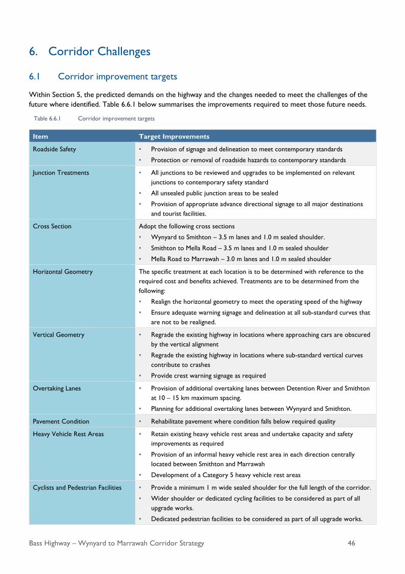
Bass Highway – Wynyard to Marrawah Corridor Strategy 46
6. Corridor Challenges
6.1 Corridor improvement targets
Within Section 5, the predicted demands on the highway and the changes needed to meet the challenges of the
future where identified. Table 6.6.1 below summarises the improvements required to meet those future needs.
Table 6.6.1 Corridor improvement targets
Item Target Improvements
Roadside Safety • Provision of signage and delineation to meet contemporary standards
• Protection or removal of roadside hazards to contemporary standards
Junction Treatments • All junctions to be reviewed and upgrades to be implemented on relevant
junctions to contemporary safety standard
• All unsealed public junction areas to be sealed
• Provision of appropriate advance directional signage to all major destinations
and tourist facilities.
Cross Section Adopt the following cross sections
• Wynyard to Smithton – 3.5 m lanes and 1.0 m sealed shoulder.
• Smithton to Mella Road – 3.5 m lanes and 1.0 m sealed shoulder
• Mella Road to Marrawah – 3.0 m lanes and 1.0 m sealed shoulder
Horizontal Geometry The specific treatment at each location is to be determined with reference to the
required cost and benefits achieved. Treatments are to be determined from the
following:
• Realign the horizontal geometry to meet the operating speed of the highway
• Ensure adequate warning signage and delineation at all sub-standard curves that
are not to be realigned.
Vertical Geometry • Regrade the existing highway in locations where approaching cars are obscured
by the vertical alignment
• Regrade the existing highway in locations where sub-standard vertical curves
contribute to crashes
• Provide crest warning signage as required
Overtaking Lanes • Provision of additional overtaking lanes between Detention River and Smithton
at 10 – 15 km maximum spacing.
• Planning for additional overtaking lanes between Wynyard and Smithton.
Pavement Condition • Rehabilitate pavement where condition falls below required quality
Heavy Vehicle Rest Areas • Retain existing heavy vehicle rest areas and undertake capacity and safety
improvements as required
• Provision of an informal heavy vehicle rest area in each direction centrally
located between Smithton and Marrawah
• Development of a Category 5 heavy vehicle rest areas
Cyclists and Pedestrian Facilities • Provide a minimum 1 m wide sealed shoulder for the full length of the corridor.
• Wider shoulder or dedicated cycling facilities to be considered as part of all
upgrade works.
• Dedicated pedestrian facilities to be considered as part of all upgrade works.
Bass Highway – Wynyard to Marrawah Corridor Strategy 47
Item Target Improvements
• Provide appropriate shoulder width for eastbound side of the Bass Highway,
east of Tollymore Road to Wynyard
Public Transport • Where adjacent to road upgrade projects, upgrade existing general access bus
stops to be compliant with DDA requirements.
6.2 Current corridor deficiencies and strategic response
Corridor deficiencies are the main issues that need to be overcome to maintain or improve transport roles and
services that the Bass Highway provides for the community. They include challenges already identified and others
that are expected to emerge as the result of future changes in land use and demographics. These challenges have
been mapped against broader Tasmanian Government Building Your Future commitments and objectives.
The Tasmanian Government priorities for responding to the Bass Highway corridor challenges are set out below.
The priorities are divided into short, medium and long term investment priorities proposed to address these
challenges. The planning of these potential works will consider where multiple projects can be combined to
maximise the financial investment and efficiency.
Implementing these actions will improve road safety, whole-of-life economic benefits and traffic efficiency. The
strategy identifies infrastructure (engineered) and operational (non-engineered) initiatives to improve road user
safety, reduce travel times and increase reliability along the Bass Highway between Wynyard and Marrawah.
A number of improvement projects identified during the study can be considered as routine maintenance
activities such as pavement repairs and line marking for which an annual budget allocation and program is already
in place. This section focuses on addressing concerns specific to the Bass Highway corridor.
Table 6.2 below lists issues that have been identified throughout the strategy development process and
summarises how the strategy will mitigate the issue.
Table 6.2 Corridor deficiencies and mitigations
Key challenges Priorities Strategic response
reference
Safety
The mix of vehicles along the Bass Highway includes cars,
caravans and heavy vehicles. The interaction between the
different vehicle types can cause potential conflict.
Widen narrow pavements
progressively.
Improve the width and alignment of
the highway in relevant sections
through the corridor.
Road Cross Section –
Section 5.4.1
Interaction between the mix of road users, including
cyclists, pedestrians and vehicles, can cause potential
conflict.
Widen narrow pavements
progressively.
Provide minimum 1 m shoulders for
the entire length of the corridor.
Road Cross Section –
Section 5.4.1
Substandard intersection geometry at a number of
locations, increases road safety risk.
Progressively improve substandard
junctions along the corridor.
Road Alignment –
Section 5.4.2 and
5.4.3

Bass Highway – Wynyard to Marrawah Corridor Strategy 48
Key challenges Priorities Strategic response
reference
Road side hazards along the corridor can cause visibility
issues
Remove or provide road side
protection of road side hazards
Sites identified as having roadside
obstructions causing visibility issues
will be provided to State Growth’s
maintenance contractor for inclusion
in works.
Road Alignment –
Section 5.4.2 and
5.4.3
The existing pavement does not adequately address the
current and future needs of freight vehicles.
Condition of the existing pavement is
monitored and managed by State
Growth under the State Growth Road
Network Maintenance Services
Contract for the north west region.
Surface condition –
Section 5.4.6
Poor delineation along sections of the corridor Progressively implement safety
treatments along the corridor.
Road Alignment –
Section 5.4.2 and
5.4.3
Travel time efficiency and reliability
Lack of overtaking lanes along the corridor impacts on
travel time and safety.
Progressively implement additional
overtaking lanes between Wynyard
and Smithton.
Overtaking
Opportunities –
Section 5.5.1
Resilience
Road closures for traffic crashes, spillages, bushfires,
flooding and other incidents along the corridor require
large detours because there is a lack of closely spaced
support networks and local and regional roads.
To mitigate this issue would require
construction of an alternate route.
While this would be beneficial, it
would also be very difficult to justify
on economic grounds given closure of
the existing highway is rare and
generally for short periods only.
Therefore, at least in the short to
medium term, there is no identified
need to construct alternate highway
routes.
Alternative Routes –
Section 5.7
Climate Change –
Section 5.8

Bass Highway – Wynyard to Marrawah Corridor Strategy 49
Key challenges Priorities Strategic response
reference
Climate change will likely increase the frequency and
severity of severe weather events that may affect
accessibility.
To mitigate this issue of the highway
that is adjacent to the coastline would
require construction of an alternate
route.
While this would be beneficial, it
would also be very difficult to justify
on economic grounds given closure of
the existing highway is rare and
generally for short periods only.
Therefore, at least in the short to
medium term, there is no identified
need to construct alternate highway
routes.
Should these events become more
frequent, this issue will be revisited.
Climate Change –
Section 5.8
Support growth and social access
Heavy vehicle access to some sections of the corridor is
limited by current intersection configuration or narrow
pavements.
Widen narrow pavements will be
widened and junctions upgraded
progressively along the corridor to
ensure pavements are appropriate for
heavy vehicle users.
Road Cross Section –
Section 5.4.1

Bass Highway – Wynyard to Marrawah Corridor Strategy 50
7. Bass Highway Corridor Priorities
7.1 Corridor improvement prioritisation
It is expected that funding for the upgrade of the Bass Highway – Wynyard to Marrawah program will occur
progressively over time. Therefore, the improvements identified in Section 6.1 will need to be prioritised so those
projects that provide the greatest immediate benefit are undertaken as early as possible.
Section 7.2 provides guidance for the prioritisation of improvement works based on assessed need determined
through the development of the corridor strategy. The actions have been classified into high, medium and low
priority by assessing the degree that each action contributes to the key strategy objectives of safety and efficiency
and on feedback provided by key stakeholders and the community.
• High priority actions are the items within the strategy that will provide a significant benefit to the safety and
/ or efficiency of the corridor and have been identified as requiring treatment in the short term.
• Medium priority actions are the items within the strategy that will provide a significant benefit to the safety
and / or efficiency of the corridor that have been identified as having a lesser priority or will be required as
transport demand increases.
• Low priority actions are items not currently identified as required within the corridor strategy but may
become a higher priority should predicted traffic demand or conditions change.
Implementing these actions will improve road safety performance, lane width, pavement condition, efficiency and
infrastructure longevity.
Table 7.1 Target improvements
Item Target Improvements Location Priority
Roadside Safety • Provision of signage and delineation
to meet contemporary standards
• Protection or removal of roadside
hazards to contemporary standards
Wynyard to Smithton High
Smithton to Mella Road High
Mella Road to Marrawah High
Junction Treatments • All Bass Highway junctions to be
reviewed and upgrades to be
implemented on relevant junctions to
contemporary safety standard
• All unsealed public junctions on the
Bass Highway to be sealed
• Provision of appropriate advance
directional signage to all major
destinations and tourist facilities.
Wynyard to Smithton High
Smithton to Mella Road High
Mella Road to Marrawah High
Cross Section • Wynyard to Smithton
3.5 m lanes and 1.0 m sealed shoulder.
Where existing seal width is
less than lane target width
High
Where existing sealed
shoulder width is less than
0.5 m
High
Where existing sealed
shoulder width is greater than
0.5 m and less than 1.0 m
Medium

Bass Highway – Wynyard to Marrawah Corridor Strategy 51
Item Target Improvements Location Priority
• Smithton to Mella Road
3.5 m lanes and 1.0 m sealed shoulder
Where existing seal width is
less than lane target width
High
Where existing sealed
shoulder width is less than
0.5 m
High
Where existing sealed
shoulder width is greater than
0.5 m and less than 1.0 m
Medium
• Mella Road to Marrawah
3.0 m lanes and 1.0 m sealed shoulder
Where existing seal width is
less than lane target width
High
Where existing sealed
shoulder width is less than
0.5 m
Medium
Where existing sealed
shoulder width is greater than
0.5 m and less than 1.0 m
Medium
Horizontal Geometry -
Realignment
The specific treatment at each location is
to be determined with reference to the
required cost and benefits achieved.
Treatments are to be determined from
the following.
• Realign the horizontal geometry to
meet the operating speed of the
highway
• Ensure adequate warning signage and
delineation at all sub-standard curves
that are not realigned.
Locations with sub-standard
horizontal alignment and
significant crash history
High
Locations with sub-standard
horizontal alignment
inconsistent with adjacent
road sections
Medium
Locations with sub-standard
horizontal alignment
consistent with adjacent road
sections
Low
Vertical Geometry -
Regrading
• Regrade the existing highway in
locations where sub-standard vertical
curves contribute to crash history
Wynyard to Marrawah High
• Regrade the highway in locations
where approaching cars are obscured
by the vertical alignment only
Wynyard to Marrawah Medium
• Provide crest warning signage at all
sub-standard locations as required
Wynyard to Marrawah High
Additional Overtaking
Lanes
• Additional overtaking lanes at 10 – 15
km maximum spacing.
Detention River to Smithton High
• Additional overtaking lanes Wynyard to Smithton Medium – as
warranted
Smithton to Marrawah Low – as
warranted
Pavement Condition • Rehabilitate pavement where
condition falls below required quality
As identified through
condition assessment
Medium to High

Bass Highway – Wynyard to Marrawah Corridor Strategy 52
Item Target Improvements Location Priority
Heavy Vehicle Rest
Areas
• Retain existing heavy vehicle rest
areas and expand capacity, entry and
exit facilities as part of adjacent road
works.
Wynyard to Smithton To be undertaken
as part of
adjacent road
upgrades
• Investigation for an informal heavy
vehicle rest area in each direction
centrally located between Smithton
and Marrawah.
Each direction centrally
located between Smithton and
Marrawah.
Low
• Investigation for a Class 5 heavy
vehicle rest area
Centrally located between
Wynyard and Smithton.
Medium
Cyclists and Pedestrian
Facilities
• Provide appropriate shoulder width
for eastbound side of the Bass
Highway, east of Tollymore Road to
Wynyard.
Tollymore Road to Wynyard To be undertaken
as part of
adjacent road
upgrades
• Provide a minimum 1 m wide sealed
shoulder for the full length of the
corridor.
Wynyard to Marrawah To be undertaken
as part of
adjacent road
upgrades
• Wider shoulder or dedicated cycling
facilities to be considered as part of
all upgrade works.
Wynyard to Marrawah To be undertaken
as part of
adjacent road
upgrades
• Dedicated pedestrian facilities to be
considered as part of all upgrade
works.
Wynyard to Marrawah To be undertaken
as part of
adjacent road
upgrades
Alternative Routes • Not considered necessary under
current or medium term traffic
demand.
Wynyard to Marrawah Low
Public Transport • Upgrade existing general access bus
stops to comply with DDA
requirements.
Wynyard to Marrawah To be undertaken
as part of
adjacent road
upgrades
Detention River Bridge Heading west along the Bass Highway, in Togari

Bass Highway – Wynyard to Marrawah Corridor Strategy 53
7.2 Corridor strategy implementation plan
The corridor strategy identifies broad infrastructure initiatives to improve road user safety and improve reliability
and efficiency along the Bass Highway for all road users.
The Corridor Strategy Implementation Plan provides a structured process and staged approach for the upgrade of
the corridor to meet current and future needs. The implementation plan identifies a priority program of projects
to deliver the actions identified in Table 7.1 (as detailed in Figure 7.1, Figure 7.2, Figure 7.3, Figure 7.4, Figure 7.5,
Figure 7.6 and Appendix A).
When developing the project program, the implementation plan considered available and possible future funding
opportunities. The implementation plan identifies a range of high and medium term priority projects, with a
number of those expected to be delivered over the coming five years, based on committed State and Australian
government funding. The availability of resources to deliver the projects is also important in achieving the
outcomes detailed. The low priority projects are projects that could be delivered over a longer period of time,
when funding is available or if traffic or road conditions warrant more immediate action. The planning of these
potential works will consider where multiple projects can be combined to maximise the financial investment and
efficiency of delivery. Implementing these projects would improve road safety, and offer economic benefits and
increase the productivity of the north west region of Tasmania.
The delivery of projects should be flexible within the timeframes provided to manage and address changes within
the corridor or program if they arise. The priority projects identified for commencement and/or delivery in 2020
include:
Boat Harbour Primary School Safety Improvements
Rocky Cape Hall Safety Improvements
Brittons Swamp Shoulder Widening
Togari Shoulder Widening
Additional works may be achieved along the corridor through other State and Australian government initiatives,
such as the Heavy Vehicle Safety and Productivity Program, Road Safety Program, Bridges Renewal Program, and
Road Maintenance Program.
The implementation of this strategy endeavours to meet the existing and future transport demands on the
corridor that are created by growing population, industry and visitor numbers.
The location and program for these works would be monitored and corridor improvement works undertaken in
conjunction with the ongoing program of maintenance works.
The Corridor Improvement Plan recommends the implementation of four new overtaking lanes, 15 sections of
the corridor to be realigned, 66 junction upgrades, and 60 km of shoulder widening work. A detailed breakdown
of the list of projects proposed has been provided in Appendix A.
The proposed upgrades that make up the Corridor Improvement Plan are shown in Figure 7.1, Figure 7.2, Figure
7.3, Figure 7.4, Figure 7.5, and Figure 7.6.
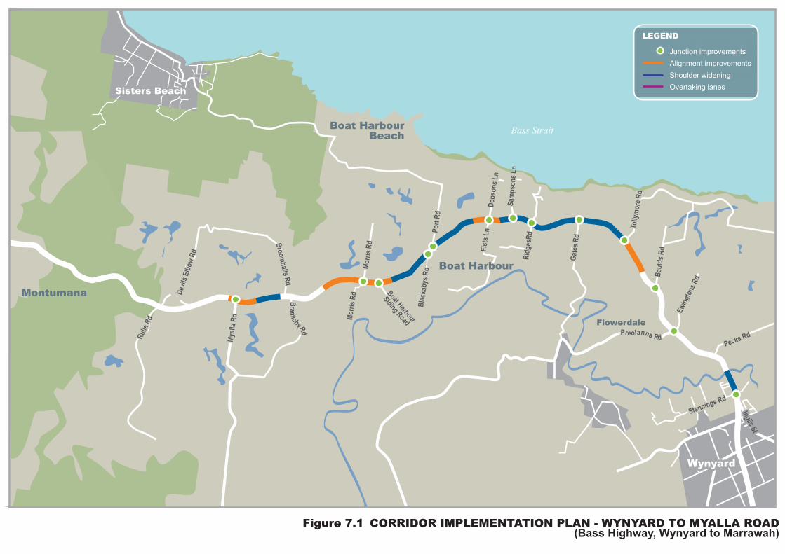
Boat HarbourBeach
Boat HarbourBoat Harbour
Montumana
Flowerdale
Myalla R
dM
yalla R
d
Rulla
Rd
Rulla
Rd
Devils E
lbo
wR
d
Devils E
lbo
wR
d
Bro
om
halls
Rd
Bro
om
halls
Rd
Pecks Rd
Pecks Rd
Stennings Rd
Stennings Rd
Inglis S
t
Inglis S
t
Ew
ingto
ns
Rd
Ew
ingto
ns
Rd
To
llym
ore
Rd
To
llym
ore
Rd
Gate
s R
dG
ate
s R
d
Rid
gesR
dR
idg
esR
d
Sam
pso
ns
Sam
pso
ns
Ln
Do
bso
ns L
nD
ob
so
ns L
n
Po
rt R
dP
ort
Rd
Bla
ckab
ys R
dB
lackab
ys R
dMo
rris
Rd
Mo
rris
Rd
Mo
rris
Rd
Mo
rris
Rd B
oat Harbour
SidingRoad
Boat H
arbour
SidingRoad
Fis
ts L
nF
ists
Ln
Bau
lds R
dB
au
lds R
d
Bass Strait
Sisters BeachSisters Beach
WynyardWynyard
Bra
michs
Rd
Bra
michs
Rd
Junction improvements
Alignment improvements
Shoulder widening
Overtaking lanes
LEGEND
Figure 7.1 CORRIDOR IMPLEMENTATION PLAN - WYNYARD TO MYALLA ROAD (Bass Highway, Wynyard to Marrawah)

Du
nn
St
Loosemore
s Rd
Loosemore
s Rd
Rocky
Cape
Rd
Rocky
Cape
Rd
Sp
eed
well R
d
Yan
ns
Rd
Yan
ns
Rd
Pin
eA
ve
Bra
keys R
dB
rakeys R
d
Mo
ntu
man
a R
d
Mo
ntu
man
a R
d
Po
llard
s R
dP
ollard
s R
d
Mo
ntu
man
a R
dM
on
tum
an
a R
d
Dal
las
Rd
Dal
las
Rd
Dete
nti
on
Riv
er
Am
aroo
Dr
EdgecombeBeach
EdgecombeBeach
Rocky CapeRocky Cape
Rocky CapeNational Park
MontumanaMontumana
ShakespeareHills Forest Reserve
Junction improvements
Alignment improvements
Shoulder widening
Overtaking lanes
LEGEND
Figure 7.2 CORRIDOR IMPLEMENTATION PLAN - MONTUMANA ROAD TO SPEEDWELL ROAD (Bass Highway, Wynyard to Marrawah)
Pebbly Bay

Bass Strait
Junction improvements
Alignment improvements
Shoulder widening
Overtaking lanes
LEGEND
Figure 7.3 CORRIDOR IMPLEMENTATION PLAN - PORT LATTA ROAD TO OLD STANLEY ROAD(Bass Highway, Wynyard to Marrawah)
Little PeggsBeach State
Reserve
PortLatta
WiltshireWiltshire
CrayfishCreekForest
Reserve
Pipeline Rd
Pipeline RdLocal R
d
Local Rd
Peggs
Rd
Peggs
Rd
Black River
Camp Site
Black River
Camp Site
Co
wrie
Po
int
Rd
Bri
ckm
akers
Beach
Access
Maw
ban
na R
d
Maw
ban
na R
d
Med
win
s R
dM
ed
win
s R
d
RdRd
Boyn
dey
Boyn
dey
Back L
ine R
dB
ack L
ine R
d
Men
gh
a R
d
Men
gh
a R
d
Sle
ep
y H
ollo
wR
d
Sle
ep
y H
ollo
wR
d
Fo
rds R
dF
ord
s R
d
Jo
cks R
dJo
cks R
d
AnthonyAnthony BeachRd
BeachRd
OldStanley
Rd
OldStanley
RdS
tan
ley H
wy
Sta
nle
y H
wy
Myrtle Grove Rd
Myrtle Grove Rd
Monateric Rd
Monateric Rd

Duck Bay
Junction improvements
Alignment improvements
Shoulder widening
Overtaking lanes
LEGEND
Figure 7.4 CORRIDOR IMPLEMENTATION PLAN - BROOKS ROAD TO SCHUURINGS ROAD (Bass Highway, Wynyard to Marrawah)
BrooksRd
BrooksRd
Beaco
mR
dB
eaco
mR
d
Lake Mikany
Back Line RdBack Line Rd
Irish
tow
nR
dIris
hto
wn
RdB
aco
nF
acto
ry R
dB
aco
nF
acto
ry R
d
Britto
ns R
d
Britto
ns R
d
Nels
on
s S
t
Nels
on
s S
t
Inn
es R
dIn
nes R
d
Ida S
co
ttC
res
Ida S
co
ttC
res
Kuban
ks R
d
Kuban
ks R
d
Ach
eso
ns R
dA
ch
eso
ns R
d
Bla
meys R
dB
lam
eys R
d
Fagans Rd
Fagans Rd
Tab
bys R
dTab
bys R
d
Sch
uu
rin
gs R
dS
ch
uu
rin
gs R
d
Rd
Rd
Dix
ons
Dix
ons
Mel
laM
ella
RdRd
SmithtonSmithton
Irishtown
Scotchtown
Broadmeadows
Mella
ChristmasHills
Sco
tch
tow
nR
dS
co
tch
tow
nR
d

Rennison rd
Christmas Hills Road
BrittonsSwampBrittonsSwamp
Togari
Rd
Rd
Riseborough Rd
Riseborough Rd
Andersons R
d
Andersons R
d
Careys RdCareys Rd
Barkers RdBarkers Rd
Smiths RdSmiths Rd
Rainbow
Hill R
d
Rainbow
Hill R
d
Eld
ridg
e R
dE
ldrid
ge R
d
Paceys R
d
Paceys R
d
Salm
on
Riv
er R
dS
alm
on
Riv
er R
d
Park
Rd
Park
Rd
Ren
nis
on
Rd
Ren
nis
on
Rd
Mo
nta
gu
Riv
er
Rd
Rd
Dunns
Dunns
Ris
ebor
ough
Ris
ebor
ough
Plains CreekForest Reserve
Brittons
Rd
Brittons
Rd
Rd
Rd
Junction improvements
Alignment improvements
Shoulder widening
Overtaking lanes
LEGEND
Figure 7.5 CORRIDOR IMPLEMENTATION PLAN - CHRISTMAS HILLS ROAD TO RENNISON ROAD (Bass Highway, Wynyard to Marrawah)

Figure 7.6 CORRIDOR IMPLEMENTATION PLAN - RENNISON ROAD TO MARRAWAH(Bass Highway, Wynyard to Marrawah)
Art
hur
Riv
er R
d
Art
hur
Riv
er R
d
Art
hur
Riv
er R
d
Com
ebac
k R
d
Com
ebac
k R
d
Com
ebac
k R
d
Ch
eq
uers
Rd
Ch
eq
uers
Rd
Ch
eq
uers
Rd
Mackays R
dM
ackays R
dM
ackays R
d
Lin
nan
es R
dL
inn
an
es R
dL
inn
an
es R
d
Fair
vie
w R
dF
air
vie
w R
dF
air
vie
w R
d
Ren
nis
on
Rd
Ren
nis
on
Rd
Ren
nis
on
Rd
Com
ebac
k R
d
Co
meb
ack R
dC
om
eb
ack R
d
Marrawah
Bond TierForest Reserve
WelcomeSwamp Forest
Reserve
Dismal SwampNature Reserve
Co
mebac
k
R
dD
ism
alR
dD
ism
alR
d
Junction improvements
Alignment improvements
Shoulder widening
Overtaking lanes
LEGEND

Bass Highway – Wynyard to Marrawah Corridor Strategy 60
7.3 Strategy review
The corridor strategy has been developed using existing data, assessment of current conditions and predicted
future traffic growth. While the future demand is based on predicted growth in population, industry and visitor
numbers, it may be that the actual demand on the highway varies over time.
It is critical that the corridor strategy continues to be periodically reviewed to monitor traffic growth and other
road conditions in relation to the improvement targets. Periodic monitoring of the implementation of
improvement projects is recommended to ensure actions are achieved, are on track or need adjustment should
conditions change.

Bass Highway – Wynyard to Marrawah Corridor Strategy 61
Appendix A
Corridor Strategy Implementation Plan

Bass Highway – Wynyard to Marrawah Corridor Strategy 62
Junction Improvements Priority
Between Wynyard and Smithton
1 Stennings Road HIGH
2 Ewingtons / Preolenna Road HIGH
3 Baulds Road HIGH
4 Tollymore Road HIGH
5 Gates Road HIGH
6 Ridges Road HIGH
7 Sampsons Lane HIGH
8 Access improvements to Boat Harbour Primary School Access HIGH
9 Fists Lane / Dobsons Lane HIGH
10 Port Road HIGH
11 Blackabys Road HIGH
12 Boat Harbour Siding Road HIGH
13 Morris Road HIGH
14 Myalla Road HIGH
15 Dallas Road HIGH
16 Montumana Road (west) HIGH
17 Rocky Cape Hall Relocation HIGH
18 Brakeys Road HIGH
19 Detention River Store Safety Improvements HIGH
20 Loosemores Road HIGH
21 Pine Avenue HIGH
22 Heath Lane HIGH
23 Amaroo Drive HIGH
24 Speedwell Road HIGH
25 Port Latta Pellet Plant and Port Facility HIGH
26 Access improvements to Brickmakers Heavy Vehicle Rest Stop HIGH
27 Access improvements to Black River Campsite HIGH
28 Medwins Road HIGH
29 Boyndey Road HIGH
30 Back Line Road HIGH
31 Myrtle Grove Road HIGH
32 Monateric Road HIGH
33 Sleepy Hollow Road HIGH

Bass Highway – Wynyard to Marrawah Corridor Strategy 63
Junction Improvements Priority
34 Anthony Beach Road HIGH
35 Old Stanley Road HIGH
36 Brittons Road HIGH
37 Bacon Factory Road HIGH
Between Smithton and Mella Road
38 Kubanks Road HIGH
39 Ida Scott Crescent HIGH
40 Innes Road HIGH
41 Achesons Road HIGH
Between Mella Road and Marrawah
42 Mella Road HIGH
43 Blameys Road HIGH
44 Tabbys / Dixons Road HIGH
45 Fagans Road HIGH
46 Shuurings Road HIGH
47 Christmas Hills Road HIGH
48 Dunns Road HIGH
49 Riseborough Road (east) HIGH
50 Andersons Road HIGH
51 Careys / Barkers Road HIGH
52 Smiths Road HIGH
53 Brittons Link HIGH
54 Rainbow Hill Road HIGH
55 Eldridge Road HIGH
56 Riseborough Road (west) HIGH
57 Paceys Road / Parks Road HIGH
58 Salmon River Road HIGH
59 Rennison Road HIGH
60 Dismal Road HIGH
61 Comeback Road HIGH
62 Fairview Road HIGH
63 Linnanes Road HIGH
64 Mackays Road HIGH
65 Chequers Road HIGH

Bass Highway – Wynyard to Marrawah Corridor Strategy 64
Junction Improvements Priority
66 Arthur River Road HIGH
Alignment Improvements Length (km) Priority
1 Between Baulds Road and Tollymore Road 0.60 HIGH
2 Boat Harbour Primary School 0.85 HIGH
3 Between Blackabys Road and Bramichs Road 1.62 HIGH
4 Myalla Road 0.47 HIGH
5 Between Montumana Road (west) and Brakeys Road 0.45 HIGH
6 Between Pine Avenue and Amaroo Drive 2.00 HIGH
7 Between Brickmakers Beach Access and Black River
Campsite 1.10 HIGH
8 Black River Campsite 0.64 HIGH
9 Medwins Road 0.71 HIGH
10 Tabbys, Dixons and Fagans Road 0.60 HIGH
11 Between Fagans Road and Schuurings Road 1.00 HIGH
12 Andersons Road 0.41 HIGH
13 Between Dismal Road and Comeback Road 2.70 MEDIUM
14 Between Fairview Road and Linnanes Road 0.59 MEDIUM
15 Mackays Road 0.58 HIGH
Overtaking Lanes Length (km) Priority
1 Eastbound overtaking lane from Dallas Road 1.31 HIGH
2 Eastbound and westbound overtaking lane between Pine
Avenue and Heath Lane, and Amaroo Drive 2.00 HIGH
3 Eastbound and westbound overtaking lane between
Brickmakers Beach and Black River Campsite 1.75 HIGH
4 Eastbound and westbound overtaking lane between Myrtle
Grove Road and Stanley Highway 1.83 HIGH

Bass Highway – Wynyard to Marrawah Corridor Strategy 65
Shoulder Widening Length (km) Priority
1 Between Inglis Street and Stennings Road 0.08 HIGH
2 Between Stennings Road and Ewingtons and Preolenna
Road 0.26 HIGH
3 Between Tollymore Road and Gates Road 0.59 MEDIUM
4 Between Gates Road and Ridges Road 0.66 MEDIUM
5 Between Ridges Road and Sampsons Lane 0.17 MEDIUM
6 Between Sampsons Lane and Boat Harbour Primary School 0.08 MEDIUM
7 Between Boat Harbour Primary School and Port Road 0.75 MEDIUM
8 Between Blackabys Road and Boat Harbour Siding Road 0.42 MEDIUM
9 Between Blackabys Road and Boat Harbour Siding Road 0.27 HIGH
10 Between Morris Road and Myalla Road 0.59 HIGH
11 Between Brakeys Road and Detention River Shop 1.30 HIGH
12 Between Detention River Shop and Loosemores Road 0.19 HIGH
13 Between Loosemores Road and Pine Avenue and Heath
Lane 0.24 HIGH
14 Between Pine Avenue and Heath Lane, and Amaroo Drive 0.09 HIGH
15 Between Amaroo Drive and Speedwell Road 0.85 HIGH
16 Between Speedwell Road and Port Latta Pellet Plant and
Port Facility 0.60 HIGH
17 Between Speedwell Road and Port Latta Pellet Plant and
Port Facility 0.46 MEDIUM
18 Between Port Latta Pellet Plant and Port Facility and
Brickmakers Rest Stop 0.70 HIGH
19 Between Black River Campsite and Medwins Road 0.62 HIGH
20 Between Boyndey Road and Back Line Road 2.21 HIGH
21 Between Myrtle Grove Road and Monateric Road 0.48 HIGH
22 Between Monateric Road and Sleepy Hollow Road 1.97 HIGH
23 Between Sleepy Hollow Road and Anthony Beach Road 4.18 HIGH
24 Between Anthony Beach Road and Old Stanley Road 0.81 HIGH
25 Between Old Stanley Road and Brittons Road 3.16 HIGH
26 Between Old Stanley Road and Brittons Road 2.91 MEDIUM
27 Between Bacon Factory Road and Kubanks road 1.25 MEDIUM
28 Between Kubanks Road and Ida Scott Crescent Road 0.48 HIGH
29 Between Ida Scott Crescent Road and Innes Road 0.93 HIGH
30 Between Innes Road and Achesons Road 0.65 HIGH

Bass Highway – Wynyard to Marrawah Corridor Strategy 66
Shoulder Widening Length (km) Priority
31 Between Achesons Road and Mella Road 1.23 HIGH
32 Between Mella Road and Blameys Road 2.08 MEDIUM
33 Between Blameys Road and Tabbys and Dixons Road 0.71 MEDIUM
34 Between Tabbys, Dixons and Fagans Road and Schuurings
Road 2.06 MEDIUM
35 Between Schuurings Road and Christmas Hill and Dunns
Road 0.35 MEDIUM
36 Between Christmas Hill and Dunns Road and Riseborough
Road 1.86 MEDIUM
37 Between Riseborough Road and Andersons Road 0.87 MEDIUM
38 Between Andersons Road and Careys and Barkers Road –
shoulder widening 0.70 MEDIUM
39 Between Andersons Road and Careys and Barkers Road –
shoulder widening and pavement rehabilitation 3.75 HIGH
40 Between Brittons Link and Rainbow Hill 0.41 MEDIUM
41 Between Rainbow Hill and Eldridge Road 2.06 MEDIUM
42 Between Eldridge Road and Riseborough Road 1.62 MEDIUM
43 Between Riseborough Road and Paceys and Parks Road –
shoulder widening and rehabilitation 1.40 HIGH
44 Between Paceys and Parks Road and Salmon River Road 1.78 HIGH
45 Between Salmon River Road and Rennison Road 0.44 MEDIUM
46 Between Rennison Road and Dismal Road 5.26 MEDIUM
47 Between Dismal Road and Comeback Road 2.57 MEDIUM
48 Between Comeback Road and Fairview Road 0.21 MEDIUM
49 Between Fairview Road and Linnanes Road 1.23 MEDIUM
50 Between Linnanes Road and MacKays Road 1.41 MEDIUM
51 Between MacKays Road and Chequers Road 0.99 MEDIUM
52 Between Chequers Road and Arthur River Road 1.40 MEDIUM
Other projects to be assessed should predicted traffic demand or conditions
change
Priority
1 Additional overtaking lanes between Smithton and Marrawah LOW
2 Investigation of Class 5 heavy vehicle rest areas MEDIUM
3 Investigation for an informal heavy vehicle rest area in each direction centrally
located between Smithton and Marrawah
LOW
4 Additional alignment or junction improvements LOW

Bass Highway – Wynyard to Marrawah Corridor Strategy 67
Other projects to be assessed should predicted traffic demand or conditions
change
Priority
5 Consideration of alternative routes LOW

Bass Highway – Wynyard to Marrawah Corridor Strategy 68
Department of State Growth
4 Salamanca Place
TAS 7000 Australia
Phone: 1800 030 068
Email: [email protected]
Web: www.stategrowth.tas.gov.au