BASIN MANAGEMENT ACTION LAN - Florida Dep · The Upper Ocklawaha River Basin Management Action Plan...
53
Final August 14, 2007 ii BASIN MANAGEMENT ACTION PLAN For the Implementation of Total Maximum Daily Loads Adopted by the Florida Department of Environmental Protection in the UPPER OCKLAWAHA RIVER BASIN Developed by the Upper Ocklawaha Basin Working Group in Cooperation with the Florida Department of Environmental Protection Division of Water Resource Management Bureau of Watershed Management August 14, 2007
Transcript of BASIN MANAGEMENT ACTION LAN - Florida Dep · The Upper Ocklawaha River Basin Management Action Plan...

Final August 14, 2007
ii
BASIN MANAGEMENT ACTION PLAN
For the Implementation of Total Maximum Daily Loads Adopted by the Florida Department of Environmental Protection
in the
UUPPPPEERR OOCCKKLLAAWWAAHHAA RRIIVVEERR BBAASSIINN
Developed by the Upper Ocklawaha Basin Working Group
in Cooperation with the Florida Department of Environmental Protection
Division of Water Resource Management Bureau of Watershed Management
August 14, 2007


Final August 14, 2007
ii
TABLE OF CONTENTS
Acknowledgments ____________________________________________________ iv
List of Acronyms _____________________________________________________ v
I. ADOPTED UPPER OCKLAWAHA RIVER BASIN MANAGEMENT ACTION PLAN ________________________ 1
Upper Ocklawaha River Basin Working Group Members and Other Participants _____________________________________________________ 2
2007 Upper Ocklawaha River Basin Management Action Plan Addressing the 2003 TMDLs__________________________________________________ 4
AP.1. Background _________________________________________________________4 AP.2. Total Maximum Daily Loads ____________________________________________5 AP.3. BMAP Process ______________________________________________________8
AP.3.1. Allocations _______________________________________________________ 10 AP.3.2. Upper Ocklawaha Basin Management Action Plan ________________________ 10
AP.4. Monitoring Program__________________________________________________22 AP.5. Tracking and Follow-up Actions ________________________________________23 AP.6. Commitment to Plan Implementation ____________________________________24
LIST OF FIGURES
Figure AP.1. Anticipated Outcomes of BMAP Implementation in Upper Ocklawaha River Basin TMDL Waters _______________________________________________17
Figure AP.2. Commitment to BMAP Implementation ________________________________25
LIST OF TABLES
Table AP.1. TMDLs in the Upper Ocklawaha River Basin _____________________________7 Table AP.2. Basin Working Group Organizational Structure ___________________________9 Table AP.3. Summary of Net Estimated Loadings of Total Phosphorus to TMDL Waters
in the Upper Ocklawaha River Basin after BMAP Implementation ____________18 Table AP.4a. Structural BMPs—Quantifiable Load Reductions ________________________20 Table AP.4b. Structural BMPs—Load Reductions Not Currently Quantified ______________20 Table AP.5. Agricultural BMPs _________________________________________________20 Table AP.6. Restoration and Water Quality Improvement Projects _____________________20 Table AP.7. Regulations, Ordinances, and Guidelines_______________________________20 Table AP.8. Special Studies and Planning Efforts __________________________________20 Table AP.9. Education and Outreach Efforts ______________________________________20 Table AP.10. Basic Stormwater Management Program Implementation _________________20 Table AP.11. Core and Supplemental Water Quality Indicators ________________________23 Table AP.12. Signatories _____________________________________________________45

Final August 14, 2007
iii
Final August 14, 2007
iv
ACKNOWLEDGMENTS
The Upper Ocklawaha River Basin Management Action Plan was prepared as part of a statewide watershed management approach to restore and protect Florida’s water quality. It was developed by the Upper Ocklawaha Basin Working Group (BWG), identified below, with participation from affected local, regional, and state governmental interests; elected officials and citizens; and private interests. The BWG would like to give special thanks to Ray Sharp and Marj Allman of the city of Leesburg for providing a comfortable place for the working group’s meetings, and arranging for morning snacks and working lunches. The BWG also would like to thank the Technical Working Group (TWG), whose members spent many hours unraveling technical details and developing information for the BWG. Special recognition goes to Mary Paulic, who coordinated and contributed greatly to the TWG’s work, and to Rolly Fulton and David Walker of the St. Johns River Water Management District, for their expert and patient technical and drafting assistance in the development of the Basin Management Action Plan. For additional information on total maximum daily loads and the watershed management approach in the Upper Ocklawaha River Basin, contact Mary Paulic Florida Department of Environmental Protection Bureau of Watershed Management, Watershed Planning and Coordination Section 2600 Blair Stone Road, Mail Station 3565 Tallahassee, FL 32399-2400 Email: [email protected] Phone: (850) 245–8560; Suncom: 205–5560 Fax: (850) 245–8434

Final August 14, 2007
v
LIST OF ACRONYMS
BMAP Basin Management Action Plan BMP Best management practice BOD Biological oxygen demand BWG Basin Working Group CARL Conservation and Recreation Lands CDBG Community Development Block Grant
CDS Continuous deflective separation, used in a device that removes sediment from stormwater
cfs Cubic feet per second Chl-a Chlorophyll a CLIP Clean Lakes Initiative Program CR County Road DACS Florida Department of Agriculture and Consumer Services DEP Florida Department of Environmental Protection DO Dissolved oxygen DOF Division of Forestry DOT Florida Department of Transportation DRI Development of Regional Impact EMC Event mean concentration EPA U.S. Environmental Protection Agency ERP Environmental Resource Permit F.A.C. Florida Administrative Code F.S. Florida Statutes FWC Florida Fish and Wildlife Conservation Commission FWRA Florida Watershed Restoration Act GIS Geographic information system GSACSC Green Swamp Area of Critical State Concern IWR Impaired Surface Waters Rule JPA Joint Planning Agreement kg Kilograms kg/ha/yr Kilograms per hectare per year lbs Pounds lbs/acre/yr Pounds per acre per year lbs/yr Pounds per year LCWA Lake County Water Authority LDRs Land development regulations LID Low-impact development MCAVA Marion County Aquifer Vulnerability Assessment MEP Maximum extent practicable mg/L Milligrams per liter MOS Margin of safety MS4 Municipal separate storm sewer system NOI Notice of Intent NPDES National Pollutant Discharge Elimination System NSRA North Shore Restoration Area NuRF Nutrient reduction facility OAWP Office of Agricultural Water Policy (DACS) OCEPD Orange County Environmental Protection Department OFW Outstanding Florida Water P2000 Preservation 2000, land acquisition program from 1990-2000 PAHs Polycyclic aromatic hydrocarbons PLRG Pollutant load reduction goal PMRA Pine Meadows Restoration Area ppb Parts per billion ppm Parts per million QA Quality assurance

Final August 14, 2007
vi
QC Quality control SCI Stream Condition Index SJRWMD St. Johns River Water Management District SOR Save Our Rivers SR State Road SRF State revolving fund SW Stormwater SWFWMD Southwest Florida Water Management District SWIM Surface Water Improvement and Management SWMP Stormwater management program TMDL Total maximum daily load TN Total nitrogen TOC Total organic carbon
TP Total phosphorus – inorganic and organic phosphorus compounds analyzed as total phosphorus
TSI Trophic State Index TSS Total suspended solids TWG Technical Working Group UF University of Florida UF–IFAS University of Florida–Institute of Food and Agricultural Sciences USACOE U.S. Army Corps of Engineers USDA U.S. Department of Agriculture USDA WRP U.S. Department of Agriculture Wetlands Reserve Program WBID Waterbody identification (number) WMD Water management district WMM Watershed Management Model WMP Watershed Management Plan WAV Watershed Action Volunteers µg/L Micrograms per liter

Final August 14, 2007
1
I. ADOPTED UPPER OCKLAWAHA RIVER BASIN MANAGEMENT
ACTION PLAN

Final August 14, 2007
2
UPPER OCKLAWAHA RIVER BASIN WORKING GROUP MEMBERS AND OTHER PARTICIPANTS
ORGANIZATION/ INTEREST GROUP
BWG REPRESENTATIVE
ELECTED OFFICIAL LIAISON
OTHER CONTRIBUTORS
LOCAL GOVERNMENT
Lake County
Fred Schneider Mary Hamilton
Elaine Renick
David Crowe David Hansen* Allan Hewitt Amye King Blanche Hardy John Kruse
Jeff Richardson Shannon Suffron Debbie Stivender** Greg Welstead Tom Wheeler Walter Wood Cathie Mcgwier Karen Rosick
Lake County Water Authority Mike Perry Lance Lumbard Sean Parks
Ron Hart
Robert Taylor**
Lake Soil and Water Conservation District
Brad Russ
Nadine Foley
Marion County Gail Mowry Andy Kesselring Troy Kuphal Shane Williams Lori Cunniff Liz Johnson Rick Baird
Orange County Dr. M. Krishnamurthy Teresa Jacobs
Robert van den Akker Julie Bortles
Penny Post Dan Homblette Ron Novy
Polk County Robert Kollinger TBD Apopka Jessica Schilling John Land
Clermont
Cheryl Parker
Jack Hogan
Preston Davis Elaine Renick** Rebecca Vanderbeck*
Eustis Chin Khor Evelyn Smith Gwen Manning** Fruitland Park John Bostic Christopher Bell
Larry Walker Groveland Teresa Greenham
Allen Sherrod
Howey-in-the-Hills Harwood Padget Chris Sears Ken Keough
Lady Lake Butch Goodman Ty Miller/ Paul Hannan
Leesburg Ray Sharp
C. Robert Lovell
Jim Richards Ed Horton David Crane
Mascotte Robert Holland Jeff Krull Mark O'Dell
Minneola Craig Raines Joe Teri
Montverde Rick Crews Dale Heathman Chris Dilley
Mount Dora Nick McRay James Yatsuk
Roberta Stegemerten Robert Thielhelm Bob Herndon
Robert Wolfe Robert Speaks** Tavares Heath Frederick
Nancy Clutts Sandy Gamble Aaron Mercer*
Umatilla Ken White TBD Tim Scobie** Glenn Irby
Winter Garden Alex Nasser Bob Buchanan Theo Graham ** David Hamstra
April Breen Robert Smith*
Ocoee Steve Krug Scott Vandergrift Tonya Elliott David Hamstra
April Breen David Wheeler*
* Former BWG representative. ** Former elected official liaison.

Final August 14, 2007
3
UPPER OCKLAWAHA RIVER BASIN WORKING GROUP
MEMBERS AND OTHER PARTICIPANTS (continued) ORGANIZATION/
INTEREST GROUP BWG
REPRESENTATIVE ELECTED OFFICIAL
LIAISON OTHER
CONTRIBUTORS REGIONAL AND STATE AGENCIES
St. Johns River Water Management District
David Walker Gene Caputo
Clay Albright
Rolland Fulton Mike Coveney
Maryann Utegg– Watershed Action Volunteers
Florida Fish and Wildlife Conservation Commission
John Benton
Dennis David
Florida Department of Agriculture and Consumer Services Carol Johnson
Jody Lee Terry Pride Florida Department of Transportation Patrick Muench
Tim Kelly Richard Fowler
Michael Hill* Robert Potts
Florida Department of Community Affairs Not Applicable
Richard Deadman
Vivian Garfein, Director Barbara Bess
Florida Department of Environmental Protection—Central District Chris Ferraro
Tom Bess Tara Plank Eric Livingston Terry Pride* Mary Paulic Xueging Gao
Florida Department of Environmental Protection—Tallahassee
Not Applicable
Fred Calder Wayne Magley PRIVATE AND ENVIRONMENTAL INTERESTS
Bill Benham Agriculture Keith Truenow
Alliance to Protect Water Resources, Inc. (APWR)
Nancy Fullerton
Ocklawaha Valley Audubon Society Linda Bystrak
ADDITIONAL PUBLIC PARTICIPANTS Andreyev Engineering Susanna Littell B&H Consulting Jim Shira Applied Sciences Don Moores
John Kiefer Tim Kelly BCI Engineering
Terry Dykehouse Walt Reigner
Boyle Engineering Sue Woodbery Mike Howe Brown and Caldwell Kurt Frahn Eustis Chamber of Commerce Sharron Semento Green Consultants Tim Green HCBassMasters A.J. Willeguer
Liz Perez Jones Edmunds
Brett Cunningham Lora Bailey
PEAR George Wolf Professional Engineering Consultants (PEC)
David Hamstra April Breen
Picciola Island Homeowners Association
Ann Griffin Ed Schlachtenhaufen
Unaffiliated Citizens
Herb Danczyk Leonard Wheeler Charles Clark
Mary Anderson Dr. Ronald Ney Ron Regan
Stormwater 360 Michael Bateman SAIC Kathy Harrigan Heather Waters
* Former BWG representative.

Final August 14, 2007
4
2007 UPPER OCKLAWAHA RIVER BASIN MANAGEMENT
ACTION PLAN ADDRESSING THE 2003 TMDLS The Upper Ocklawaha River Basin Management Action Plan (BMAP) was developed by basin stakeholders over a two-year period. The BMAP addresses waters in the Upper Ocklawaha River Basin that the Florida Department of Environmental Protection (DEP) has identified as impaired, for which Total Maximum Daily Loads (TMDLs) have been established. The BMAP does not address all of the water quality issues in the basin but focuses on reducing total phosphorus (TP)1 discharges to surface waters that are identified as impaired. The BMAP documents the management actions that have been or will be undertaken by local, regional, state, or private entities to reduce the amount of TP released into the basin. Reducing the discharges of TP into the basin will help achieve water quality standards and designated uses established by DEP. DEP has designated that the water quality of the Upper Ocklawaha River Basin should be suitable for recreational use and for the propagation and maintenance of a healthy, well-balanced population of fish and wildlife. The TP reductions achieved by the management actions included in the BMAP will help the Upper Ocklawaha River Basin attain this designated use. While developing the BMAP, the Upper Ocklawaha Basin Working Group (BWG) discussed the basin’s water quality issues and placed each issue into one of three categories. Primary issues are directly linked to TMDLs and were targeted during this BMAP cycle. Secondary issues are those that generally result from impacts of the primary issues. Finally, other issues that did not have a substantial link to the current TMDLs were also identified. This BMAP presents a plan for reducing nutrient loadings in the basin using a phased approach. During the first five-year cycle, the BWG members will focus on reducing the larger pollution sources. The BWG members will also be evaluating other pollution sources that require additional research or that represent a relatively smaller percentage contribution to the total loading. The adopted BMAP reflects this phased implementation of TMDLs. The BMAP should be considered a working document. It is a plan that outlines management actions, establishes a strategy to monitor implementation and water quality trends, and establishes a framework for adapting the plan when needed. The plan is discussed in further detail in the following sections. AP.1. Background
The Upper Ocklawaha BMAP has been developed as part of DEP’s TMDL Program (authorized by the Florida Watershed Restoration Act [FWRA] [Section 403.067, Florida Statutes [F.S.]). DEP implements the act using a watershed management approach that includes a five-year rotating basin cycle. Each year of the cycle represents a different activity for the waters within a given basin group, as follows: Initial Basin Assessment,
1 TP is the combined measurement of phosphorus as orthophosphate (PO4), other inorganic phosphorus compounds, and organic phosphorus compounds found in water and expressed as amounts of phosphorus. TP is used in aquatic science as a measure of the biological productivity of a waterbody. It is one of the primary nutrients regulating algal and macrophyte growth in natural waters, particularly in fresh water. While it is essential to the growth of plants and other organisms in aquatic systems, excessive amounts increase the rate of plant growth and cause accelerated eutrophication and algal blooms. Phosphorus is a limiting nutrient in many ecosystems, meaning that its availability controls the growth rate of plants and other organisms. Orthophosphate, the form in which almost all inorganic forms of phosphorus are found in the water column, can enter the aquatic environment in a number of ways. Natural processes transport phosphate to water through atmospheric deposition, ground water percolation, and terrestrial runoff. Municipal treatment plants, industries, agriculture, stormwater runoff, and other domestic activities also contribute to phosphate loading through direct discharge and natural transport mechanisms. .
Final August 14, 2007
5
Strategic Monitoring, Data Analysis and TMDL Development, Basin Management Action Plan Development; and Basin Management Action Plan Implementation. At the end of each five-year, five-phase cycle, a new cycle begins for each group of basins in which additional waters may be identified for TMDL establishment and implementation. The Upper Ocklawaha River Basin is located mostly in Lake County. It also encompasses the northwest portion of Orange County, southern Marion County, and the northern part of Polk County. The basin includes the following waterbodies of interest:
Lake Apopka and the Apopka-Beauclair Canal;
The Clermont Chain of Lakes (Minneola, Minnehaha, and Louisa, along with 12 other smaller lakes), connected by the Palatlakaha River;
The Harris Chain of Lakes including Lakes Harris, Dora, Beauclair, Eustis, Little Harris, and Carlton, Dead River; Dora Canal and Trout Lake along with
Lake Griffin and Lake Yale, the Yale-Griffin Canal, some tributaries to Lake Griffin, Emeralda Marsh, and Haynes Creek.
AP.2. Total Maximum Daily Loads
TMDLs are water quality targets for waterbodies that DEP has identified as impaired for specific pollutants (such as TP, total nitrogen [TN], and others). TMDLs, which DEP adopts by rule, establish the maximum amount of specific pollutants that a waterbody can assimilate while maintaining water quality standards, which are indicated by designated uses. All surface waters (including wetlands) in the Upper Ocklawaha River Basin are designated as Class III waters in accordance with Rule 62-302, Florida Administrative Code (F.A.C.), meaning that they must have suitable water quality for recreational use and for the propagation and maintenance of a healthy, well-balanced population of fish and wildlife. To establish a TMDL, DEP assesses each impaired waterbody, the pollutant(s) contributing to the impairment, and the amount of the pollutant(s) entering the waterbody during a specified period. DEP then determines the level of pollutant(s)—the TMDL—that each waterbody can receive and still maintain its Class III designated use (the TMDL), and calculates the corresponding pollutant reduction needed to achieve the TMDL. Ten waterbodies in the basin did not meet their designated uses and were verified by DEP as impaired. TP is the primary pollutant contributing to the impairment of all these waterbodies. In Trout Lake and the Palatlakaha River, TN contributes to the problem, and biological oxygen demand (BOD) is also identified as a pollutant contributing to the impairment in the Palatlakaha River. In 2003, DEP adopted TMDLs for the following 10 impaired waterbodies and associated tributary and connecting canals and streams (e.g., Haynes Creek, Dead River, Apopka-Beauclair Canal, Dora Canal, Helena Run, Apopka Spring, and Yale-Griffin Canal) in the Upper Ocklawaha River Basin:

Final August 14, 2007
6
Lake Apopka
Lake Beauclair
Lake Carlton
Lake Dora
Lake Eustis
Trout Lake
Lake Harris (includes Little Lake Harris)
Palatlakaha River (north of State Road [SR] 50)
Lake Griffin
Lake Yale
Table AP.1 lists the TMDLs for these waterbodies. As part of the second rotation of the basin management cycle in the Upper Ocklawaha River Basin, DEP is collecting data to further analyze the water quality impairments in the basin and establish additional TMDLs.

Final August 14, 2007
7
TABLE AP.1. TMDLS IN THE UPPER OCKLAWAHA RIVER BASIN
WASTELOAD ALLOCATIONS WATERBODY IDENTIFICATIONS
WBID(S) TMDL TARGET
CONCENTRATION TMDL BASELINE
LOAD1 WASTEWATER
NPDES STORMWATER2
LOAD ALLOCATION (NONPOINT)
OVERALL NEEDED REDUCTION SUB-BASIN
(lbs/yr) (ppb) (lbs/yr) (lbs/yr) (% reduction) (lbs/yr) (lbs/yr) LAKE APOPKA TOTAL PHOSPHORUS 3
2835A,C,D 35,052 55 137,451 2,668 None 31,216 102,399
LAKE BEAUCLAIR TOTAL PHOSPHORUS
2834C 7,056 32 46,672 None 85 7,056 39,616
LAKE CARLTON TOTAL PHOSPHORUS
2837B 195 32 477 None 59 195 282
LAKE DORA TOTAL PHOSPHORUS 2831A,B 13,230 31 39,646 None 67 13,230 26,416 LAKE EUSTIS/ HAYNES CREEK TOTAL PHOSPHORUS
2817A,B 20,286 25 35,503 None 43 20,286 15,217
TROUT LAKE TOTAL PHOSPHORUS 521 28 2,604 None 80 521 2,083 TOTAL NITROGEN
2819A 9,733 780 24,165 None 60 9733 14,432
LAKE HARRIS/ LITTLE LAKE HARRIS TOTAL PHOSPHORUS
2838A,B
2832/2817C 18,302 26 26,864 None 32 18,302 8,562 PALATLAKAHA RIVER BOD 43,042 None 49,351 None 12.8 43,042 6,309 TOTAL NITROGEN 16,696 None 17,604 None 5.2 16,696 908 TOTAL PHOSPHORUS
2839 2,207 None 2,350 None 6.1 2,207 143 LAKE GRIFFIN TOTAL PHOSPHORUS
2814A 26,901 32 77,881 None 66 26,901 50,980
LAKE YALE/ LAKE YALE CANAL TOTAL PHOSPHORUS
2807A 2807 2,844 20 3,158 None 10 2,844 314
Note: lbs/yr – pounds per year ppb – parts per billion 1 TMDL baseline loads were taken from more recent estimates by the SJRWMD, except for the Palatlakaha River, Lake Carlton, and Trout Lake, whose loadings were estimated by DEP. Most of the baseline loading estimates developed by SJRWMD were calculated for the period from 1991–2000; Lake Apopka loadings are calculated for the period from 1989–94. DEP estimated baseline loadings for Lake Carlton from 1991–2000 and Trout Lake from 1995–2000. The baseline loading year for the Palatlakaha River was 1991. 2 NPDES Stormwater refers to discharges associated with municipal separate storm sewer systems (MS4s), which are discussed in Section 3.4.2 of the supporting document. The reduction required is a percent of the current MS4 discharge. 3 Numbers for Lake Apopka were converted from metric tons per year. The TMDL includes an explicit margin of safety (MOS) of 1,168 lbs/yr.

Final August 14, 2007
8
AP.3. BMAP Process
The BMAP development process is structured to achieve cooperation and consensus among a broad range of interested parties. Stakeholder involvement is essential to develop, gain support for, and secure commitments to implement the BMAP. Under statute, DEP invited stakeholders to participate in the Upper Ocklawaha BMAP development process and encouraged public participation to the greatest practicable extent. DEP held three noticed public meetings in the basin to discuss and receive comments during the planning process. In June 2004, DEP convened the Upper Ocklawaha BWG to develop a BMAP to achieve the TMDLs for the basin. Stakeholders chose unanimously to establish one BWG, with the option of creating small working groups to address specific concerns or issues. Members of the BWG comprise these subgroups, which meet separately from the BWG. The BWG, which is made up of stakeholder members representing a variety of entities, took a consensus-based, collaborative approach when making decisions on the content of the BMAP. It was necessary to define what constitutes a consensus agreement for the BWG, short of unanimous agreement. However, the BWG concluded that accepting a proposal without full unanimity would be a default position, when necessary to move the process forward and to complete development of the BMAP on schedule. The BWG agreed to make every effort to develop proposals that all members could support. Table AP.2 summarizes the Upper Ocklawaha River BWG organizational structure, process, membership, and citizen involvement efforts. The members of the BWG met nearly monthly from June 2004 through June 2006 with subsequent meetings on November 9, 2006; January 25, 2007; and April 21, 2007. To solicit participation from the general public, ads announcing the BWG meeting were periodically placed in the local newspaper, the Daily Commercial. As discussion with BWG members proceeded to a point where decisions about the specific responsibilities of each partner were discussed, meetings were formally noticed in the Florida Administrative Weekly. The BWG created a Technical Working Group (TWG) with the responsibility of providing a technical review of issues before the BWG and reporting that information back to the BWG for their discussion. The TWG met on an as-needed basis at the request of the BWG and usually in conjunction with a BWG meeting. Four public meetings/workshops were also held (on April 15, 2004; March 10, 2005; November 10, 2005; and May 18, 2006) to solicit comments from all interested parties, disseminate information, and allow for public discussion. In addition, a number of special briefings and presentations were carried out as needed for city councils, county commissions, elected official liaisons from local governments, special interest groups, community organizations, and others.

Final August 14, 2007
9
TABLE AP.2. BASIN WORKING GROUP ORGANIZATIONAL STRUCTURE
BASIN WORKING GROUP (BWG) Function: • Develop a consensus-based BMAP to implement TMDLs in the Upper Ocklawaha River Basin • Has final decision-making role on BMAP development • Includes Technical Working Group (TWG) subcommittee Makeup: • Lake County and 12 municipalities in the county:
− City of Clermont − City of Eustis − City of Fruitland Park − City of Groveland − Town of Lady Lake − City of Leesburg − City of Mascotte − City of Minneola − Town of Montverde − City of Mount Dora − City of Tavares − City of Umatilla
• Lake County Water Authority • Marion County • Orange County and 3 municipalities in the county:
− City of Apopka − City of Ocoee − City of Winter Garden
• Polk County • St. Johns River Water Management District • Florida Department of Transportation • Florida Fish and Wildlife Commission • Florida Department of Agriculture and Consumer Services • Florida Department of Environmental Protection • Agriculture industry representative • Alliance for the Protection of Water Resources (environmental representative)
Meetings/Workshops Held: • Monthly meetings generally held on the second Thursday of the month from June 2004 to June 2006, with subsequent meetings held on:
- November 9, 2006 - January 25, 2007 - April 21, 2007
CITIZEN INPUT Function: • Ensure that all interested parties are involved and heard in the TMDL process • Ensure the broad dissemination of TMDL information and the BMAP • Allow for public discussion of issues and strategies Makeup: • Interested parties and the public at large General Public Meetings/Workshops Held: • April 15, 2004 • March 10, 2005 • November 10, 2005 • May 18, 2006 Note: Several interested citizens also attended the BWG meetings regularly
SPECIAL BRIEFINGS/PRESENTATIONS (AS NEEDED) Function: • To brief councils, commissions, special interest groups, community organizations, and others on the TMDL process and the progress of
the BWG, as requested or needed Makeup: • Affected and/or interested elected bodies, organizations, and other groups in the basin
ELECTED OFFICIAL LIAISONS Role/Function: • Serve as point of contact for elected local governing bodies • Represent the citizens in their jurisdictions • Attend BWG and public meetings, as desired • Provide feedback to the BWG • Assist in developing effective means of informing and involving elected officials, and in securing their endorsement of a consensus
BMAP Makeup: • One elected official appointed by and representing each local government participating in BMAP development. Periodic briefings as a
group to the individual elected officials appointed by each local government to serve as a liaison to the BMAP development process. Elected Official Liaison Briefings: • January 26, 2005 October 26, 2005 Local Government Elected Body Briefings: • April 2006 January 2007

Final August 14, 2007
10
AP.3.1. Allocations The TMDL provides a basis for allocating acceptable loads among all of the known pollutant sources in a watershed, so that appropriate control measures can be implemented and water quality standards achieved. An adopted TMDL is expressed as the sum of all point source load allocations, nonpoint source load allocations, and an implicit or explicit MOS, which takes into account any uncertainty concerning the relationship between effluent limitations and water quality. Under the FWRA (Subsection 403.067[7], F.S.), the TMDL allocation may be an “initial” pollutant allocation of allowable pollutant loads among point and nonpoint sources. In such cases, the “detailed” allocation to specific point sources and specific categories of nonpoint sources must be established in the BMAP. The FWRA further states that the BMAP may make detailed allocations to individual “basins” (i.e., sub-basins) or to all basins as a whole, as appropriate. Both initial and detailed allocations must be determined based on a number of factors listed in the FWRA, including cost-benefit, technical and environmental feasibility, implementation time frames, and others. The Upper Ocklawaha BWG agreed that, for the purposes of the initial BMAP, it would not be appropriate to try to calculate more specific allocations than those adopted as part of the TMDL. Therefore, the “detailed” allocation chosen was to all sub-basins as a whole, based on the following considerations: There are no significant point sources in the Upper Ocklawaha River Basin. The
complexity of calculating more detailed allocations among nonpoint sources would demand time and effort that would delay plan development without benefiting the outcome.
Major restoration projects by the SJRWMD and the Lake County Water Authority (LCWA) are projected to substantially reduce pollutant loadings. In addition, Lake County, Orange County, and various local governments are conducting and planning significant stormwater projects that will contribute to load reductions. Local governments in the basin are increasingly taking responsibility for managing their discharges to surface waters.
There is a wide range of experience, expertise, and resources among the local governments and other entities in the basin responsible for stormwater management. The BMAP process is an opportunity for some to build on their beginning efforts and for others to share their knowledge and resources.
AP.3.2. Upper Ocklawaha Basin Management Action Plan The BWG determined that management actions addressing TP, for which all 10 waterbodies in the basin are impaired, should reduce the other pollutants for which TMDLs were established. Therefore, the BWG focused on developing a plan that would reduce TP loadings to the impaired waters.
This section provides significant information on the types of management actions being implemented by the BWG members. Information is provided on the types of actions considered and programs administered in the basin by the SJRWMD; the Florida Department of Agriculture and Consumer Services (DACS); the LCWA; and Lake,

Final August 14, 2007
11
Orange, Polk, and Marion Counties. Table AP.3 summarize the net reductions in TP loading that will be achieved for each of the 10 impaired waterbodies. Tables AP.4 through AP.10 include specific information on individual projects implemented by BWG members. The tables contain net estimated reduction in TP loads for each project as well as an estimate of the cost of implementation. The final discussion in this section focuses on future TP loadings and reductions. Information is provided on how future TP loadings from growth were considered in this process and how the BWG will investigate and consider additional management actions over the next 5 years. The Upper Ocklawaha River BMAP represents the collaborative effort of local stakeholders in the basin to identify current and planned management actions to achieve the TMDLS for TP. The management actions (completed, ongoing, and planned) identified in the BMAP are targeted at addressing both the pollutant loads from historical and current sources and from the estimated future loads associated with population growth and associated land use changes in the basin. The management actions included in the BMAP by the BWG recognize and build on numerous existing programs that reduce pollutant loads to the Upper Ocklawaha River Basin. The BWG relied on the water quality and quantity programs its member organizations were already implementing as a source of projects that addressed the water quality impairments identified in the Upper Ocklawaha River Basin TMDLs. To meet the targeted pollutant load reductions, the BMAP includes specific projects from stormwater control programs (such as the SJRWMD’s Environmental Resource Permit [ERP] Program), existing land acquisition, water conservation, low impact development (LID) programs, and programs in response to special areas (i.e, the Wekiva Study Area), as well as Surface Water Improvement and Management (SWIM) Program plans implemented by the SJRWMD. The activities identified in the BMAP complement and depend on these programs, but do not replace them as a mechanism to achieve the pollutant reduction goals estimated in the BMAP. The BWG has developed the Upper Ocklawaha BMAP as a planning document that presents an overview of the issues and efforts across the basin and summarizes the implemented and planned activities addressing TP reductions in the basin. Additional documents that support the projects, studies, and programs may be included in the BMAP. The range of management actions identified includes activities such as the following: Stormwater Retrofits:
o Paving and drainage upgrades, o Failing infrastructure replacement and improvement, and o Sediment and debris collection boxes (baffle boxes).
Urban Structural Best Management Practices (BMPs):
o Regional wet detention stormwater ponds, and o Dry retention stormwater ponds.
Urban Nonstructural BMPs:
o Street sweeping, and

Final August 14, 2007
12
o Cleaning up pet waste. `
Habitat Restoration:
o Marsh construction, o Wetland restoration, and o Gizzard shad harvesting.
Ordinances and Land Development Regulations (LDRs):
o Development guidelines, o Septic tank ordinances, and o Local stormwater rules more stringent than state or water management district
rules.
Education and Outreach:
o Watershed Action Volunteers (WAV) Program, o Lakefront property owner’s guides, and o Water atlases.
Agricultural BMPs:
o Crop rotation, o Filter strips, and o Exclusion of livestock from sensitive areas.
Efforts by the St. Johns River Water Management District The projects implemented by the SJRWMD through the Lake Apopka and Upper Ocklawaha SWIM Plans have significantly reduced TP loading to impaired waters in the basin and improved aquatic habitat throughout the basin. The Lake Apopka and Upper Ocklawaha SWIM Plans were first adopted in 1987 and 1989, respectively, in compliance with the 1987 SWIM Act (Sections 373.451–373.4596, F.S.). Further reductions in TP loading resulting from restoration projects in these SWIM plans are a major component of the strategy to achieve TMDLs in the basin. The Upper Ocklawaha River Basin SWIM area includes the Harris Chain of Lakes north of Lake Apopka and the Upper Ocklawaha River to the confluence of the Silver River near SR 40 in Marion County. The restoration efforts of both the Lake Apopka and Upper Ocklawaha SWIM Plans focus primarily on reducing nutrients and other pollutants in stormwater that flows into SWIM waterbodies from former agricultural areas (muck farms). Other efforts include in-lake treatment to reduce the recycling of nutrients by harvesting gizzard shad, re-establishing more natural water level fluctuations and flows, and restoring aquatic and wetland habitats at former muck farms. Within the area addressed by the Upper Ocklawaha River BMAP, activities that exceed SJRWMD permitting thresholds must be authorized by an ERP. To obtain an ERP where existing ambient water quality does not meet state water quality standards, an applicant must demonstrate that the proposed activity will result in a net improvement in the parameters that do not meet water quality standards.

Final August 14, 2007
13
Efforts by the Florida Department of Agriculture and Consumer Services (and Private Agricultural Producers) In addition to the specific management actions identified in the BMAP, the implementation of agricultural BMPs in the basin contributes to pollutant load reductions. Through the Office of Agricultural Water Policy (OAWP) and Division of Forestry, DACS develops, adopts, and implements agricultural BMPs to improve water quality and water conservation. DACS has adopted by rule BMPs that target the following operations in the basin: Ridge citrus (Rule 5E-1.023, F.A.C.),
Leatherleaf fern (Rule 5E-1.023, F.A.C.),
Interim measure for container-grown plants (Rule 5E-1.023, F.A.C.),
Vegetable and agronomic crops (Rule 5M-8, F.A.C.), and
Silviculture (Rule 5I-6.002, F.A.C.).
The OAWP’s BMP implementation role involves assisting agricultural producers in selecting, funding, and maintaining BMPs. OAWP staff and service providers work with producers to submit Notices of Intent (NOIs) to implement BMPs that identify the measures appropriate for their operations. Service providers also give technical assistance to producers and help implement cost-share programs that leverage regional, state, and federal funds.
Although DACS’ BMP program is nonregulatory, Subsection 403.067(7)(b), F.S., requires that nonpoint pollutant sources (such as agriculture) included in a BMAP demonstrate compliance with pollutant reductions established to meet a TMDL, either by implementing BMPs or conducting water quality monitoring prescribed by DEP or a water management district. To date, producers in the Upper Ocklawaha River Basin from the Ridge citrus, container-grown plant, and fern industries have submitted NOIs (covering about 13,500 acres) to implement rule-adopted BMPs. Efforts by the Lake County Water Authority The LCWA is a key funding partner for local jurisdictions throughout the basin. This grant funding has enabled numerous stormwater retrofit projects identified in the BMAP. In addition, the LCWA is proposing to construct a nutrient reduction facility (NuRF) to further treat water released from Lake Apopka and provide the timely achievement of TMDL goals for Lakes Beauclair, Dora, Eustis, and Griffin. The NuRF will eliminate an additional 65 percent of the TP load to Lake Beauclair. This reduction will positively affect Lakes Dora, Eustis, and Griffin as well, since the Lake Apopka discharge represents a significant portion of their hydrologic budget. Additional TP reduction is important because Lake Apopka’s TMDL target concentration is almost twice as high as the targets for the lakes downstream. The project’s estimated load reduction to Lake Beauclair is 5,000 lbs/yr, based on the remaining load to Lake Beauclair after projected improvements to Lake Apopka by current restoration efforts. Efforts by Local Governments Four counties and 15 towns and cities participated in developing the Upper Ocklawaha BMAP. The BMAP identifies numerous projects completed or proposed by these local

Final August 14, 2007
14
governments that address untreated stormwater discharges to the lakes. The stormwater retrofit projects include activities ranging from the installation of baffle boxes to the creation of detention ponds. These governments have also developed ordinances that address critical issues such as redevelopment requirements, green space, and septic tank maintenance. The efforts of these jurisdictions are an essential component of the BMAP. All four counties (Lake, Marion, Orange, and Polk) that contribute to the Upper Ocklawaha River Basin have established comprehensive programs for addressing pollutant loads, in addition to individual stormwater retrofit and other treatment projects. Lake County and Orange County have made significant contributions to pollutant control and load reductions in the basin. Lake County has taken a proactive approach toward TMDLs by focusing its basin studies and concentrating immediate stormwater retrofit efforts on the Upper Ocklawaha River Basin. These studies will help in the design of cost-effective projects to manage stormwater and reduce TP loads to TMDL waters. Through cost-share project partnerships, the county provides additional support to other local governments working to reduce pollutant loadings. Orange County has also implemented a variety of programs, including the following: The Clean Lakes Initiative Program (CLIP) to provide educational and financial
incentives to help citizens take individual ownership of their lakefront and watershed, and
An agreement by the Parks Department to reduce the use of phosphorus fertilizer and herbicide applications on all parklands.
Marion County has initiated several programs and resource assessment activities, such as the development of a countywide Watershed Management Plan, a Water Resource Assessment and Management Study, and a Springshed Protection Program. The county’s Clean Water Program is partnering with the University of Florida’s Program for Resource Efficient Communities to develop and conduct seminars on LID options and results for water resources. Polk County is not heavily developed in the area discharging to the Upper Ocklawaha River Basin. Future development for most of the area is restricted as part of the Green Swamp Area of Critical State Concern (GSACSC). Development in the remaining acreage, most of it former citrus groves, will be provided central sewer service and reuse water for irrigation. Net Estimated Loadings of Total Phosphorus to TMDL Waters The BWG calculated a net estimated loading for each sub-basin, beginning with the TP loads estimated in the TMDL analysis as its baseline. The BWG then factored in the TP reductions expected from the proposed management actions along with estimated TP loadings from future development (through 2010). After considering these three factors (baseline, management actions, and future growth), the BWG determined a net estimated TP load for each sub-basin. Starting with the baseline loadings for sources of TP in each sub-basin, the BWG reviewed the estimated change in TP loading after the implementation of projects and

Final August 14, 2007
15
activities in this plan. This analysis factored in the estimated load reductions from implemented and planned projects and the estimated loading changes associated with future growth, resulting in a net estimated TP load for each impaired waterbody. Implemented projects are those completed as of the end of 2005. Future projects are those planned for initiation or completion after 2005. The estimated load changes from future growth are based primarily on future land use maps. These net loadings may be updated as part of BWG follow-up on BMAP implementation.
The BWG’s analysis also considered changes in the tributary contribution to a waterbody’s nutrient load. In general, this TP load changes proportionally with the change in upstream water quality. For example, implemented and future acquisition and restoration projects in Lake Apopka have improved water quality to the extent that the TP load to Lake Beauclair, just downstream, will be reduced by 35,752 lbs/yr. These improvements in upstream water quality are reflected in the nutrient load for each affected downstream waterbody. A net TP load for the lake or waterbody is estimated after factoring in all the projected changes in loading.
Figure AP.1 presents a map of the anticipated outcomes of BMAP implementation in the Upper Ocklawaha River Basin TMDL waters. This map illustrates the importance of addressing the TP load reductions in Lake Apopka to achieving the targeted load reductions in the downstream lakes (e.g., Beauclair, Dora, and Eustis). The SJRWMD restoration and treatment programs provide the most significant load reduction efforts in the basin. The SJRWMD’s ERP permit requirements will help sustain the water quality improvements achieved through restoration. The net effect of the load reduction in Lake Apopka will be to benefit the downstream lakes by reducing the TP load coming into the lakes. Table AP.3 presents numeric data on the anticipated outcomes of BMAP implementation and provides specific details on the current and anticipated load reductions from different types of activities for each sub-basin. The table also presents the net estimated loading of TP to TMDL waters in the Upper Ocklawaha River Basin after BMAP implementation of the proposed management actions. The data presented in the table represent only the projects that have quantifiable TP load reductions. There are many additional projects where the TP load reduction cannot be quantified. Figure AP.1 and Table AP.3 clearly show the large TP load reductions that will be achieved through BMAP implementation by BWG organizations. The last column of the table summarizes how more than 244,000 lbs/yr of TP are projected to be removed from the Upper Ocklawaha River Basin. Although the estimates used in the table and to create the figure are conservative (e.g., water quality improvements associated with nonquantifiable load reductions are not considered) they do indicate that additional effort is needed to achieve all of the targeted TP reductions for all impaired lakes in the basin. Additional studies and assessments are included as part of the BMAP to characterize the sources and management opportunities in these sub-basins.
The BMAP presents a plan for reducing nutrient loadings in the basin using a phased approach. During the first five-year cycle, the BWG members will focus on reducing the larger pollution sources. The BWG members will also be evaluating other pollution sources that require additional research or that represent a relatively smaller percentage contribution to the total loading.

Final August 14, 2007
16
Some issues, such as septic tanks, were not directly addressed during the first five years of the BMAP implementation, because of they represent a relatively small percentage of pollutant loading. The relative importance of loadings from some sources (e.g., septic tanks, future growth) increases after the implementation of the BMAP’s management actions, which will reduce TP loadings by 244,349 lbs/yr. For these issues, BWG members are implementing a variety of activities. Some will conduct detailed sub-basin studies to characterize nutrient sources to the lakes and build on existing ordinances, and may, in some areas, consider additional treatment strategies (e.g., advanced septic systems design or centralized wastewater treatment facilities). Others may also revise land use development regulations or update public education strategies to address nutrient loads. In addition, the communities of Lake County, Mount Dora, Eustis, Orange County, Apopka, Ocoee, and Winter Garden are participating in an extensive effort to reduce the water quality impacts on springs and river systems as part of the Wekiva Springs Protection Effort implementing the Wekiva Parkway and Protection Act.
BWG efforts to implement the proposed management actions, monitor their implementation and water quality trends in the basin, further characterize pollutant sources, and evaluate additional load reduction options are all critical to a phased implementation approach. It is especially critical for the sub-basins that are currently not projected to achieve the TMDL target (e.g., Lakes Carlton, Harris, and Yale, and Trout Lake). The additional research and evaluation of options to be conducted by BWG members is essential. The BWG members involved in these efforts will research the issues in their communities and make the appropriate management decisions for their citizens.
With this consideration, the BMAP should be considered a working document that includes a strong plan of management actions to address the larger pollution sources and research to improve the understanding of the basin and the additional measures needed to meet the TMDL targets.
In addition, an adaptive management approach will be used during BMAP implementation to identify and make modifications to the BMAP when circumstances change, or feedback mechanisms indicate that a more effective strategy is needed. Tracking implementation, monitoring water quality and pollutant loads, and holding periodic BWG meetings to share information and expertise are key components of the adaptive management approach to be used. Sections AP.4 and AP.5 present details of the monitoring, tracking, and follow-up strategy.

Final August 14, 2007
17
FIGURE AP.1. ANTICIPATED OUTCOMES OF BMAP IMPLEMENTATION IN UPPER OCKLAWAHA RIVER BASIN TMDL WATERS

Final August 14, 2007
18
TABLE AP.3. SUMMARY OF NET ESTIMATED LOADINGS OF TOTAL PHOSPHORUS TO TMDL WATERS IN THE UPPER OCKLAWAHA RIVER BASIN AFTER BMAP
IMPLEMENTATION
Sub-basins Lake
Apopka
Lake Beau-clair
Lake Carlton (trib to Lake Beau-clair)
Lake Dora
Lake Eustis
Trout Lake
(trib to Lake
Eustis)
Lake Harris & Little
Lake Harris
Palatla-kaha
(trib to Lake
Harris) Lake
Griffin
Lake Yale
(trib to Lake
Griffin) Basinwide
Totals
Net Estimated Loads Loading information
TMDL Baseline TP-loading (lbs/yr) 137,451 46,672 477 39,646 35,503 2,604 26,864 2,350 77,881 3,158 372,606
a. Tributary inflows - - -26,015 - - -20,071 -10,762 - - - - - - -7,813 - - -64,661
b. Agricultural discharges -117,015 - - - - - - -746 - - -174 - - -22,703 - - -140,638
c. Restoration 37,477 - - - - -603 - - -4,441 - - -18,747 - - -13,686
d. Stormwater -35 - - - - 8 -313 - - -98 - - -202 - - -640
e. Point sources or other treatment options 1,256 - - - - - - - - - - - - - - - - -109 1,147
f. Explicit margin of safety 1,168 - - - - - - - - - - - - - - - - - - 1,168 (Subtotal) Estimated change from implemented projects
(TP loading lbs/yr) -77,149 -26,015 0 -20,063 -12,424 0 -4,713 0 -49,465 -109 -189,938
a. Tributary inflows -134 -9,746 - - -11,379 -6,114 - - -99 - - -4,310 - - -31,984
b. Agricultural discharges 0 - - - - - - -458 -19 - - - - - - - - -477
c. Restoration -26,231 - - - - -138 -726 -2,465 - - 415 - - -29,145
d. Stormwater 0 - - - - - - -145 - - -150 -13 -185 - - -493
e. Point sources or other treatment options - - -5,000 - - - - - - - - - - - - - - - - -5,000
f. Explicit margin of safety - - - - - - - - - - - - - - - - - - - - 0 (Subtotal) Estimated change from future projects (TP
loading lbs/yr) -26,365 -14,746 0 -11,379 -6,855 -745 -2,714 -13 -4,080 0 -66,897
Estimated change from implemented and future projects (TP loading lbs/yr) -103,514 -40,761 0 -31,442 -19,279 -745 -7,427 -13 -53,545 -109 -256,835
Estimated change from growth (TP loading lbs/yr – 2001–2010) 0 831 240 1,263 3,040 592 2,874 346 2,694 606 12,486
Estimated change from projects and growth (TP-loading lbs/yr) -103,514 -39,930 240 -30,179 -16,239 -153 -4,553 333 -50,851 497 -244,349
Net estimated TP-loading (lbs/yr) 33,937 6,742 717 9,467 19,264 2,451 22,311 2,683 27,030 3,655 128,257
TMDL (Total Maximum Daily Load) (lbs/yr) 35,052 7,056 195 13,230 20,286 521 18,302 2,207 26,901 2,844 126,594
Additional TP load reduction needed 0 0 522 0 0 1,930 4,009 476 129 811 7,877
Load
ing
Cha
nges
from
Im
plem
ente
d Pr
ojec
ts
Load
ing
Cha
nges
from
Fu
ture
Pro
ject
s

Final August 14, 2007
19
* TP load reductions for implemented and future projects are represented by negative values (a minus sign) ** All other TP loadings (e.g., baseline, increases, net estimated, TMDLs, and additional load reductions) needed are indicated by positive values. *** If there is no load reduction or increase associated with a specific category of implemented or future project, a double dash " - - " is shown. ****Numbers in the Basinwide Totals column are estimates as double counting of loadings occurred during TMDL development for Lake Carlton and Lake Beauclair and for Trout Lake and Lake Eustis. Trout Lake is part of the watershed loading contributing to Lake Eustis and Lake Carlton is part of the watershed loading contributing to Lake Beauclair.

Final August 14, 2007
20
Cost of BMAP Implementation The estimated cost of the management actions included in the Upper Ocklawaha BMAP totals more than $195 million. Funding sources range from local stormwater fees to regional and state cost-share grants. BWG members will explore new opportunities for funding assistance as part of BMAP follow-up. This estimate does not include costs for the implementation of DACS programs and DOT stormwater projects. Members of the BWG proposed projects that were part of their existing programs, as well as new projects or programs where additional effort was needed to address pollutant load reductions. In many cases the projects proposed in the BMAP are jointly funded or implemented by multiple organizations. The BWG assumed that responsible organizations considered the proposed projects cost-effective for achieving TP reductions as well as other community-based benefits (e.g., reducing flooding, eliminating direct discharges to a lake). Specific Management Actions Included in the BMAP Tables AP.4 through AP.10, listed below, summarize the management actions proposed by the BWG to address the TMDLs in the basin, including structural BMPs; agricultural BMPs; restoration and water quality improvement projects; regulations, ordinances, and guidelines; special studies and planning efforts; education and outreach efforts; and basic stormwater management program implementation. The tables are extensive and therefore are provided at the end of the chapter.
TABLE AP.4A. STRUCTURAL BMPS—QUANTIFIABLE LOAD REDUCTIONS
TABLE AP.4B. STRUCTURAL BMPS—LOAD REDUCTIONS NOT CURRENTLY QUANTIFIED
TABLE AP.5. AGRICULTURAL BMPS
TABLE AP.6. RESTORATION AND WATER QUALITY IMPROVEMENT PROJECTS
TABLE AP.7. REGULATIONS, ORDINANCES, AND GUIDELINES
TABLE AP.8. SPECIAL STUDIES AND PLANNING EFFORTS
TABLE AP.9. EDUCATION AND OUTREACH EFFORTS
TABLE AP.10. BASIC STORMWATER MANAGEMENT PROGRAM IMPLEMENTATION
Estimates of Future Loadings from Growth and Future Management Actions As mentioned above, the TP loadings considered as part of the BMAP included those associated with future growth across the basin. Consequently, the management actions considered by stakeholders include pollution prevention activities that address TP loadings from new development (or redevelopment) through regulations, ordinances, or guidelines. There are also many management actions in the BMAP aimed at preventing water quality problems through public and private sector education and outreach. The preventive management actions are considered Lake- and Stream-friendly Activities. They can include LID planning and engineering, education, and local ordinances or LDRs that protect water quality by maintaining or enhancing predevelopment water flow and reducing pollutant loads in developing and urban watersheds.

Final August 14, 2007
21
Tables AP.4 through AP.10 present current Lake- and Stream-friendly Activities implemented by the BWG, but these activities are predominantly found in Table AP.3 (regulations, ordinances, and guidelines) and Table AP.9 (education and outreach efforts). The BWG will consider additional Lake- and Stream-friendly Activities through the following steps: 1. The collection of data/inventory of Lake- and Stream-friendly Activities across the
Upper Ocklawaha River Basin. This will include an inventory of what each community is currently doing and/or has planned, and an assessment of the lessons learned from the implementation of these efforts (i.e., level of activity and success of activity in helping to protect and/or improve water quality).
2. The distribution of a summary of the inventory and the lessons learned by BWG members during the implementation of these activities. The summary will identify incentives for and obstacles to implementation and success.
3. The development of a plan for future Lake- and Stream-friendly management actions in the basin, consideration of existing and new ideas, and identification of the most effective techniques that should be considered by jurisdictions and entities in the Upper Ocklawaha River Basin to improve and/or expand the implementation of key/successful approaches.
4. The creation of proposals for improved, expanded, and/or new activities by individual jurisdictions and entities, or collectively by the BWG. Proposals will also include incentives for using LID planning techniques, educational opportunities, and/or ordinance and policy changes.
DACS also plans to address future agricultural loadings. To meet the intent of the FWRA with regard to agriculture, from 2007 to 2011 the OAWP will carry out the following activities: Adopt BMP manuals of statewide application for cow/calf, equine, container-grown
plants, in-ground nurseries, and sod operations.
Intensify its efforts to sign up producers for BMP implementation in the Upper Ocklawaha River Basin. Field staff will meet with growers and grower organizations to inform them of existing and new BMP programs and opportunities for cost-share, and to assist them with BMP selection and NOI submittal.
Work with UF-IFAS and DEP to identify priority citrus BMPs and verify their effectiveness.
Develop a BMP implementation assurance program to follow up with a sample of citrus producers on whether they are implementing BMPs and keeping records according to their submitted NOIs.
Evaluate the need for implementation assurance programs for other commodities in the basin and develop them on a priority basis, as needed and feasible.
By April 2008, and annually thereafter, provide to the Upper Ocklawaha BWG an inventory of NOIs in the basin by BMP program, showing acreages or other applicable reporting metrics, and key BMPs being implemented.
By the end of 2011, report to the BWG on:

Final August 14, 2007
22
o The findings of any citrus or other BMP effectiveness projects relevant to the basin being conducted by or in partnership with the OAWP, and
o The results and progress of any BMP implementation assurance programs being conducted by the OAWP in the basin.
AP.4. Monitoring Program
As part of the BMAP, the TWG designed a strategy for monitoring water quality and measuring pollutant loads. This strategy builds on existing water quality monitoring program commitments made by DEP, the SJRWMD, Lake County, Orange County, WAV volunteers, and the LCWA. The strategy addresses monitoring design, quality assurance (QA), data management, and data interpretation techniques that measure progress in achieving the TMDLs, while allowing for evaluation and feedback that better refine the monitoring strategy and provide information to better define how to achieve the TMDLs. The objectives of the monitoring strategy are as follows: Primary Objective: Monitor TMDL waterbodies to:
o Determine whether the target TP concentrations used to develop the TMDLs are being achieved, and
o Determine whether expected improvements in other water quality indicators are being achieved.
Secondary Objective: Measure loadings of TMDL targeted pollutants as:
o Tributary loadings, and o Loadings associated with specific sources or projects, as feasible.
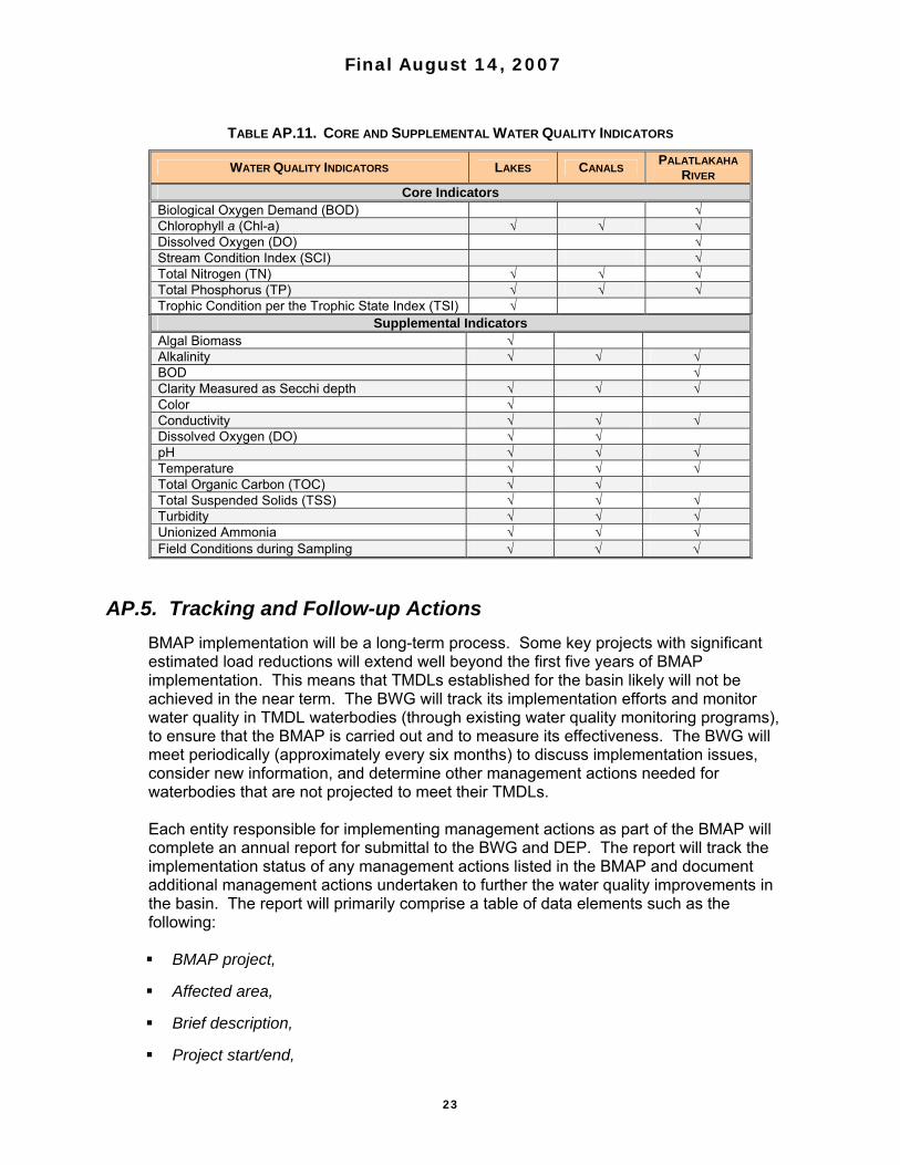
A network of stations representative of the impaired lakes, the tributaries between the lakes, and the Palatlakaha River are monitored for the water quality indicators listed in Table AP.11. Information provided by the monitoring network will be useful in evaluating the cost-effectiveness of load reduction strategies, modifying existing and selecting future load reduction strategies, coordinating agency/group monitoring efforts to reduce duplication and conserve resources, and increasing the understanding of the relationship between pollutant loads and waterbody response. Data collected by the network are maintained by DEP in a central database available to partners, and must meet QA requirements set by DEP. Additional interagency data comparisons and QA checks will be conducted as practical. Observations of water quality conditions and trends will be reported to the BWG and the public at least annually. A more complete analysis of trends in the progress made toward achieving designated use will be made on a five-year basis, corresponding with DEP’s watershed management cycle.
Final August 14, 2007
23
TABLE AP.11. CORE AND SUPPLEMENTAL WATER QUALITY INDICATORS
WATER QUALITY INDICATORS LAKES CANALS PALATLAKAHA RIVER
Core Indicators Biological Oxygen Demand (BOD) √ Chlorophyll a (Chl-a) √ √ √ Dissolved Oxygen (DO) √ Stream Condition Index (SCI) √ Total Nitrogen (TN) √ √ √ Total Phosphorus (TP) √ √ √ Trophic Condition per the Trophic State Index (TSI) √
Supplemental Indicators Algal Biomass √ Alkalinity √ √ √ BOD √ Clarity Measured as Secchi depth √ √ √ Color √ Conductivity √ √ √ Dissolved Oxygen (DO) √ √ pH √ √ √ Temperature √ √ √ Total Organic Carbon (TOC) √ √ Total Suspended Solids (TSS) √ √ √ Turbidity √ √ √ Unionized Ammonia √ √ √ Field Conditions during Sampling √ √ √
AP.5. Tracking and Follow-up Actions
BMAP implementation will be a long-term process. Some key projects with significant estimated load reductions will extend well beyond the first five years of BMAP implementation. This means that TMDLs established for the basin likely will not be achieved in the near term. The BWG will track its implementation efforts and monitor water quality in TMDL waterbodies (through existing water quality monitoring programs), to ensure that the BMAP is carried out and to measure its effectiveness. The BWG will meet periodically (approximately every six months) to discuss implementation issues, consider new information, and determine other management actions needed for waterbodies that are not projected to meet their TMDLs. Each entity responsible for implementing management actions as part of the BMAP will complete an annual report for submittal to the BWG and DEP. The report will track the implementation status of any management actions listed in the BMAP and document additional management actions undertaken to further the water quality improvements in the basin. The report will primarily comprise a table of data elements such as the following: BMAP project,
Affected area,
Brief description,
Project start/end,

Final August 14, 2007
24
Project/activity status,
TP removal estimate,
Project monitoring results, and
Comments.
The BWG will review the annual reports to assess progress in meeting the goals of the BMAP. At its semiannual meetings, the BWG will also develop follow-up steps or modifications to the agreed-on management actions as necessary to achieve the targeted pollutant reductions. Adaptive management involves setting up a mechanism for making course corrections in the BMAP when circumstances change or feedback mechanisms indicate that a more effective strategy is needed. The FWRA requires that the plan be revised, as appropriate, in collaboration with basin stakeholders. All or part of a revised BMAP must be adopted by secretarial order. Adaptive management measures include the following: Procedures to determine whether additional cooperative actions are needed,
Criteria/process for determining whether and when plan components need to be revised due to changes in costs, environmental impacts, social effects, watershed conditions, or other factors, and
Descriptions of the BWG’s role after BMAP completion.
Tracking implementation, monitoring water quality and pollutant loads, and holding periodic BWG meetings to share information and expertise are key components of adaptive management.
AP.6. Commitment to Plan Implementation
While the BMAP is linked by statute to permitting and other enforcement processes that target individual entities, successful implementation requires that local stakeholders willingly and consistently work together to achieve adopted TMDLs. This collaboration fosters the sharing of ideas, information, and resources. The members of the Upper Ocklawaha BWG have demonstrated their willingness to confer with and support each other in their efforts. BWG members have signed individual statements of commitment to BMAP implementation, or adopted resolutions that were collected and kept by DEP as part of the record of BMAP development and implementation. Figure AP.2 provides an example of the statement of commitment, and Table AP-12 (at the end of this chapter) lists the signatories to the BMAP.

Final August 14, 2007
25
FIGURE AP.2. COMMITMENT TO BMAP IMPLEMENTATION
2007
UPPER OCKLAWAHA RIVER BASIN MANAGEMENT ACTION PLAN
STATEMENT OF COMMITMENT TO PLAN IMPLEMENTATION
The Upper Ocklawaha River Basin Management Action Plan (BMAP) was finalized as a consensus document on April 26, 2007, by authorized representatives of the agencies and organizations listed as members of the Upper Ocklawaha River Basin Working Group (BWG).
The signatories of the BMAP agree that, as applicable, their organizations and agencies will:
Seek the necessary approvals and funding to implement the consensus management actions identified in the BMAP, and implement those actions as required approvals and funding are secured.
Pursuant to the process agreed upon by the BWG, track the implementation of
management actions for which they are responsible to ensure that the BMAP is carried out.
Inform DEP and the BWG of any permanent obstacles to carrying out
management actions for which they are responsible, including technical, funding, and legal obstacles.
Conduct water quality monitoring according to the monitoring strategy developed
by the Technical Working Group and approved by the BWG.
Continue to use a coordinated and comprehensive watershed management approach to address and achieve TMDL-related pollutant load reductions and water quality improvements.
Continue to communicate and coordinate actions and funding across agencies
and programs with regard to BMAP implementation.

Final August 14, 2007
26
TABLE AP.4A. STRUCTURAL BMPS—QUANTIFIABLE LOAD REDUCTIONS
Project Number - Project Name General Location / Description
Estimated TP Load
Reduction (lbs/yr)
Waterbody Identification
(WBID) Number
Lead Entity / Funding Source / Project Partners Project Cost
Project Status / Completion Date or Anticipated
Completion Date
DORA04 - SR 500 US 441-Basin 300A
Lake Saunders / US 441 from Lake Eustis Dr. to County Road (CR) 44B Basin 300A. Exfiltration
trench. No increase in TP with road improvement. 3.04 2831B DOT, District 5 / Florida
Legislature / -- Not available Ongoing / Projected completion 8/2007
DORA05 - SR 500 US 441-Basin 300A,B,C,D
Lakes Saunders and Woodward / US 441 from Lake Eustis Dr. to CR 44B - Basin 300A, B, C, & D. -10.51 2831B DOT, District 5 / Florida
Legislature / -- Not available Ongoing / Projected completion 8/2007
DORA09 - State Road 19 in Tavares-System 1
Lake Eustis / SR 19 from 1.9 miles south of US 441 to US 441 - System 1 (Basins 1-4). Wet pond detention. -2.02 2831B DOT, District 5 / Florida
Legislature / -- Not available Complete / Complete
DORA10 - State Road 19 in Tavares-System II
Dora Canal / SR 19 from 1.9 miles south of US 441 to US 441 - System II (Basins 1 & 2). Wet pond detention. No increase in TP load with road
improvement. 1.19 2831B DOT, District 5 / Florida
Legislature / -- Not available Complete / Complete
DORA11 - State Road 19 in Tavares-System III
Dora Canal / SR 19 from 1.9 miles south of US 441 to US 441 - System III (Basins 1 & 2). Wet pond detention. No increase in TP load with road
improvement. 7.78 2831B DOT, District 5 / Florida
Legislature / -- Not available Complete / Complete
EUS02 - Haynes Creek Park Retrofit
Haynes Creek Park located on South Haynes Creek Rd. near Ocklawaha Rd. / Dry retention pond and about 400 ft. of retention ditches with ditch blocks along South Haynes Creek Rd. Site is county park in single-family residence neighborhood. Park captures runoff from
8.2-acre watershed via South Haynes Creek Rd.
6.40 2817A; 2817B
Lake County Public Works / Lake County Stormwater Assessment - 50%; Legislature - 50% ( 4 project
total: $185,851 - Lake County Stormwater assessment; $185,851
) / --
Design* - $16,759.25
construction* - $92,925.75 (4 project total:
design - $67,037, construction -
$371,703)
Complete / 2004
EUS06 - Eustis Street/Ward Avenue Stormwater Facility
Eustis St. and Ward Ave. / Divert stormwater runoff to dry detention pond via storm sewer retrofit for total treatment and storage. Divert stormwater runoff to
pond instead of discharge into Lake Eustis. 36.26 2817B City of Eustis / LCWA - 50% ;
Legislature - 50% / LCWA / DEP $355,550 Complete / 8/1/2003
EUS07 - Salem Street and Magnolia Avenue
Retrofit
Salem St. and Magnolia Ave. / Divert stormwater runoff to dry detention pond via storm sewer retrofit for total treatment and storage. Divert stormwater runoff to
pond instead of discharge into Lake Eustis. 62.54 2817B City of Eustis / DOT - $600,000;
EUSTIS - $150,000 / DOT $750,000 Complete / 2001
EUS08 - South Grove Street and Palm Avenue
Stormwater Facility
South Grove St. Eustis / Divert stormwater runoff to dry detention pond via storm sewer retrofit for total
treatment and storage. Divert stormwater runoff to pond instead of discharge into Lake Eustis.
32.41 2817B City of Eustis/LCWA / LCWA - $56,000; EUSTIS - $58,700 / -- $114,700 Complete / 2002
EUS09 - Barnes Avenue and Center Street
Retrofit
Barnes Ave. and Center St. / Divert stormwater runoff to dry detention pond via storm sewer retrofit for total treatment and storage. Divert stormwater runoff to
pond instead of discharge into Lake Eustis. 4.84 2817B City of Eustis / Eustis - $100,000 /
-- $100,000 Complete / 2003
EUS10 - Stevens Avenue Retrofit
Stevens Ave. and Donnelly St. / Divert stormwater runoff to dry detention pond via store sewer retrofit for
total treatment and storage. Construction of new storm sewers. Divert runoff prior to discharge into Lake Eustis to new detention pond at Stevens Ave. and
Donnelly St.
40.64 2817B City of Eustis / DOT - $990,000;Eustis - $75,000 / DOT $1,065,000 Complete / 2006
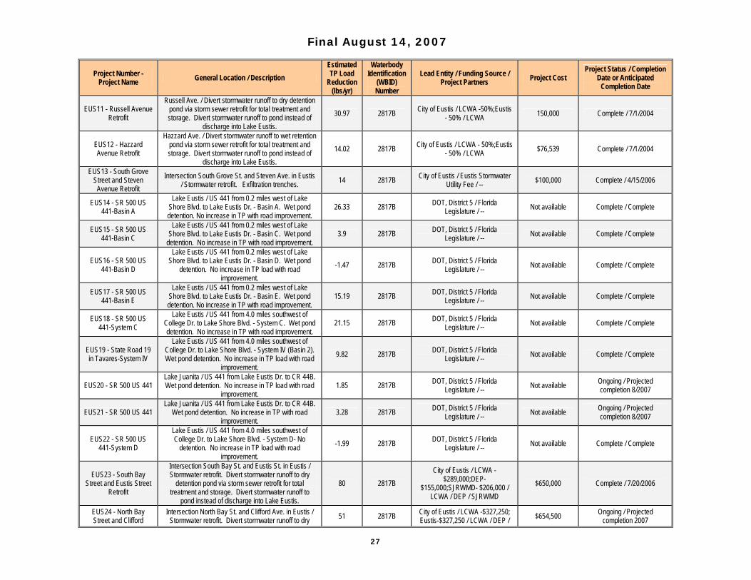
Final August 14, 2007
27
Project Number - Project Name General Location / Description
Estimated TP Load
Reduction (lbs/yr)
Waterbody Identification
(WBID) Number
Lead Entity / Funding Source / Project Partners Project Cost
Project Status / Completion Date or Anticipated
Completion Date
EUS11 - Russell Avenue Retrofit
Russell Ave. / Divert stormwater runoff to dry detention pond via storm sewer retrofit for total treatment and storage. Divert stormwater runoff to pond instead of
discharge into Lake Eustis. 30.97 2817B City of Eustis / LCWA -50%;Eustis
- 50% / LCWA 150,000 Complete / 7/1/2004
EUS12 - Hazzard Avenue Retrofit
Hazzard Ave. / Divert stormwater runoff to wet retention pond via storm sewer retrofit for total treatment and storage. Divert stormwater runoff to pond instead of
discharge into Lake Eustis. 14.02 2817B City of Eustis / LCWA - 50%;Eustis
- 50% / LCWA $76,539 Complete / 7/1/2004
EUS13 - South Grove Street and Steven
Avenue Retrofit Intersection South Grove St. and Steven Ave. in Eustis
/ Stormwater retrofit. Exfiltration trenches. 14 2817B City of Eustis / Eustis Stormwater Utility Fee / -- $100,000 Complete / 4/15/2006
EUS14 - SR 500 US 441-Basin A
Lake Eustis / US 441 from 0.2 miles west of Lake Shore Blvd. to Lake Eustis Dr. - Basin A. Wet pond detention. No increase in TP with road improvement.
26.33 2817B DOT, District 5 / Florida Legislature / -- Not available Complete / Complete
EUS15 - SR 500 US 441-Basin C
Lake Eustis / US 441 from 0.2 miles west of Lake Shore Blvd. to Lake Eustis Dr. - Basin C. Wet pond
detention. No increase in TP with road improvement. 3.9 2817B DOT, District 5 / Florida
Legislature / -- Not available Complete / Complete
EUS16 - SR 500 US 441-Basin D
Lake Eustis / US 441 from 0.2 miles west of Lake Shore Blvd. to Lake Eustis Dr. - Basin D. Wet pond
detention. No increase in TP load with road improvement.
-1.47 2817B DOT, District 5 / Florida Legislature / -- Not available Complete / Complete
EUS17 - SR 500 US 441-Basin E
Lake Eustis / US 441 from 0.2 miles west of Lake Shore Blvd. to Lake Eustis Dr. - Basin E. Wet pond detention. No increase in TP with road improvement.
15.19 2817B DOT, District 5 / Florida Legislature / -- Not available Complete / Complete
EUS18 - SR 500 US 441-System C
Lake Eustis / US 441 from 4.0 miles southwest of College Dr. to Lake Shore Blvd. - System C. Wet pond detention. No increase in TP with road improvement.
21.15 2817B DOT, District 5 / Florida Legislature / -- Not available Complete / Complete
EUS19 - State Road 19 in Tavares-System IV
Lake Eustis / US 441 from 4.0 miles southwest of College Dr. to Lake Shore Blvd. - System IV (Basin 2). Wet pond detention. No increase in TP load with road
improvement. 9.82 2817B DOT, District 5 / Florida
Legislature / -- Not available Complete / Complete
EUS20 - SR 500 US 441 Lake Juanita / US 441 from Lake Eustis Dr. to CR 44B. Wet pond detention. No increase in TP load with road
improvement. 1.85 2817B DOT, District 5 / Florida
Legislature / -- Not available Ongoing / Projected completion 8/2007
EUS21 - SR 500 US 441 Lake Juanita / US 441 from Lake Eustis Dr. to CR 44B.
Wet pond detention. No increase in TP with road improvement.
3.28 2817B DOT, District 5 / Florida Legislature / -- Not available Ongoing / Projected
completion 8/2007
EUS22 - SR 500 US 441-System D
Lake Eustis / US 441 from 4.0 miles southwest of College Dr. to Lake Shore Blvd. - System D- No
detention. No increase in TP load with road improvement.
-1.99 2817B DOT, District 5 / Florida Legislature / -- Not available Complete / Complete
EUS23 - South Bay Street and Eustis Street
Retrofit
Intersection South Bay St. and Eustis St. in Eustis / Stormwater retrofit. Divert stormwater runoff to dry
detention pond via storm sewer retrofit for total treatment and storage. Divert stormwater runoff to
pond instead of discharge into Lake Eustis.
80 2817B City of Eustis / LCWA -
$289,000;DEP-$155,000;SJRWMD- $206,000 /
LCWA / DEP / SJRWMD $650,000 Complete / 7/20/2006
EUS24 - North Bay Street and Clifford
Intersection North Bay St. and Clifford Ave. in Eustis / Stormwater retrofit. Divert stormwater runoff to dry 51 2817B City of Eustis / LCWA -$327,250;
Eustis-$327,250 / LCWA / DEP / $654,500 Ongoing / Projected completion 2007

Final August 14, 2007
28
Project Number - Project Name General Location / Description
Estimated TP Load
Reduction (lbs/yr)
Waterbody Identification
(WBID) Number
Lead Entity / Funding Source / Project Partners Project Cost
Project Status / Completion Date or Anticipated
Completion Date
Avenue Retrofit detention pond via storm sewer retrofit for total treatment and storage. Divert stormwater runoff to
pond instead of discharge into Lake Eustis.
SJRWMD
GRIF05 - Lazy Oaks Retrofit
Lazy Oaks community located on western side of Lake Griffin, on shore of lake. / Lake Griffin basin retrofit
projects. Exfiltration trench. Rental cottages in Lazy Oak community and single-family residential
development on western side of Lake Griffin. Steep slopes convey stormwater as sheetflow over paved surface within Lazy Oaks. Adjacent subdivision with
fairly large lots. Stormwater from 4-acre area conveyed by roadside swales to 12-inch outfall pipe into Lake Griffin. Exfiltration system will retain 80% of annual
runoff volume, corresponding to 0.28 to 0.45 inches of runoff volume. 490 feet of exfiltration trench proposed.
19 2814A
Lake County Public Works / Lake County Stormwater Assessment - 50%; Legislature - 50% ( 4 project
total: $185,851 - Lake County Stormwater assessment; $185,851
- Lake County Water Authority stormwater grant) / LCWA / DEP
design* - $16,759.25
construction* - $92,925.75 (4 project total:
design - $67,037, construction -
$371,703)
Complete / 2004
GRIF06 - Griffwood Community Retrofit
Griffwood Community Mobile Home Park located on western side of Lake Griffin. / Lake Griffin basin retrofit projects. Exfiltration trench. Site has steep slopes and
dense development. Exfiltration with drainage inlets located in roadway at bottom of hill. Exfiltration system
designed to treat first 0.5 inch of runoff, which represents 76% of annual runoff volume. System comprises 440 feet of 3-foot exfiltration system.
33.00 2814A
Lake County Public Works / Lake County Stormwater Assessment - 50%; Legislature - 50% ( 4 project
total: $185,851 - Lake County Stormwater assessment; $185,851
- Lake County Water Authority stormwater grant) / LCWA / DEP
design* - $16,759.25
construction* - $92,925.75 (4 project total:
design - $67,037, construction -
$371,703)
Complete / 2004
GRIF07 - Brittany Estates Retrofit
Brittany Estates Mobile Home Park community located on southern side of Lake Griffin / Lake Griffin basin retrofit project. Exfiltration trench and expansion of existing retention pond. Densely populated mobile
home park with steep slopes. Existing dry detention pond at bottom of hill that overflowed during heavy
storms. Roads have inverted crown configuration that convey stormwater. Exfiltration system and larger dry detention pond to treat runoff. Exfiltration will treat first
0.5 inch of runoff from 4.65-acre upper contributing basin, representing 76% of annual runoff volume. 221
feet of 3-foot exfiltration pipe. Lower 5.1-acre basin fitted with 240 feet of 3-foot exfiltration pipe. Shallow
berm along Lake Griffin to direct runoff to larger redesigned dry detention pond. Existing 6-inch outfall pipe replaced with control structure, headwall, and new
pipe.
12.50 2814A
Lake County Public Works / Lake County Stormwater Assessment - 50%; Legislature - 50% ( 4 project
total: $185,851 - Lake County Stormwater assessment; $185,851
- Lake County Water Authority stormwater grant) / LCWA / DEP
design* - $16,759.25
construction* - $92,925.75 (4 project total:
design - $67,037, construction -
$371,703)
Complete / 2005
GRIF10 - Whispering Pines Regional
Stormwater Retrofit
Whispering Pines Basin / Stormwater retrofit. Construction of 2 stormwater ponds. Expected 66%
reduction in TP. 130 2814A Leesburg / Leesburg - 50%;
LCWA - 50% / LCWA / DEP $1.5 million Ongoing / Projected completion 12/1/2007
GRIF12 - Lake Griffin State Park Retrofit Lake Griffin State Park / Stormwater retrofit. 11.0 2814A DEP / DEP - 50%; LCWA - 50% /
LCWA $82,535 Complete / 6/1/2004
GRIF13 - SR 500 US 441-Basin 100
Lake Griffin / US 441 from west of Griffin Rd. to east of Perkins St. - Basin 100. Wet pond detention. No
increase in TP load with road improvement. 54.66 2814A DOT, District 5 / Florida
Legislature / -- Not available Pending / Projected start 9/2008
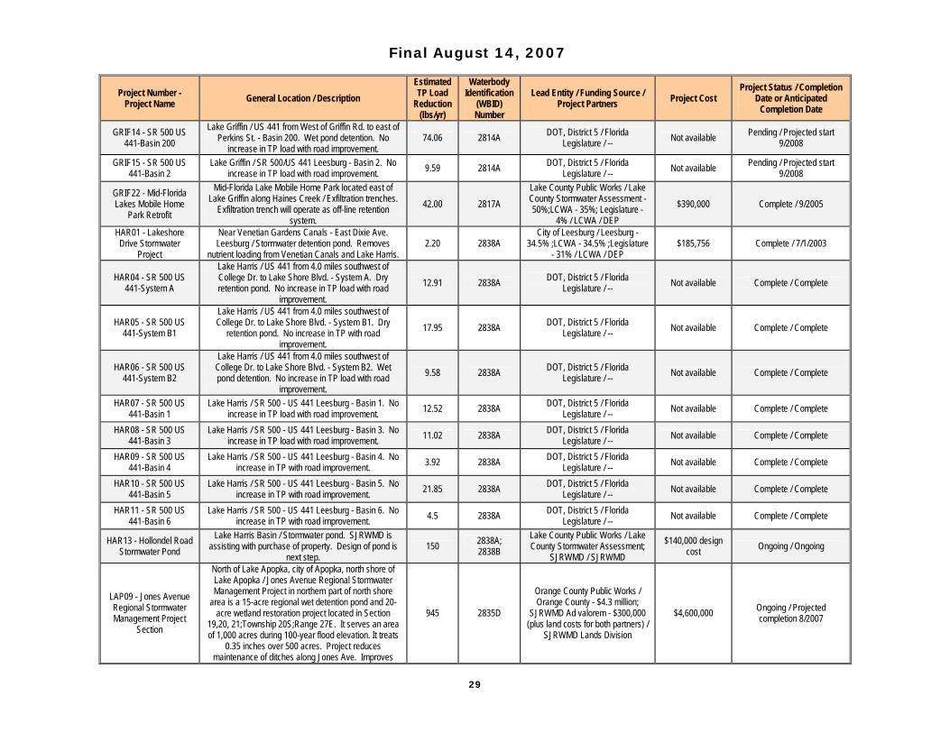
Final August 14, 2007
29
Project Number - Project Name General Location / Description
Estimated TP Load
Reduction (lbs/yr)
Waterbody Identification
(WBID) Number
Lead Entity / Funding Source / Project Partners Project Cost
Project Status / Completion Date or Anticipated
Completion Date
GRIF14 - SR 500 US 441-Basin 200
Lake Griffin / US 441 from West of Griffin Rd. to east of Perkins St. - Basin 200. Wet pond detention. No
increase in TP load with road improvement. 74.06 2814A DOT, District 5 / Florida
Legislature / -- Not available Pending / Projected start 9/2008
GRIF15 - SR 500 US 441-Basin 2
Lake Griffin / SR 500/US 441 Leesburg - Basin 2. No increase in TP load with road improvement. 9.59 2814A DOT, District 5 / Florida
Legislature / -- Not available Pending / Projected start 9/2008
GRIF22 - Mid-Florida Lakes Mobile Home
Park Retrofit
Mid-Florida Lake Mobile Home Park located east of Lake Griffin along Haines Creek / Exfiltration trenches.
Exfiltration trench will operate as off-line retention system.
42.00 2817A Lake County Public Works / Lake County Stormwater Assessment - 50%;LCWA - 35%; Legislature -
4% / LCWA / DEP $390,000 Complete / 9/2005
HAR01 - Lakeshore Drive Stormwater
Project
Near Venetian Gardens Canals - East Dixie Ave. Leesburg / Stormwater detention pond. Removes
nutrient loading from Venetian Canals and Lake Harris. 2.20 2838A
City of Leesburg / Leesburg - 34.5% ;LCWA - 34.5% ;Legislature
- 31% / LCWA / DEP $185,756 Complete / 7/1/2003
HAR04 - SR 500 US 441-System A
Lake Harris / US 441 from 4.0 miles southwest of College Dr. to Lake Shore Blvd. - System A. Dry retention pond. No increase in TP load with road
improvement. 12.91 2838A DOT, District 5 / Florida
Legislature / -- Not available Complete / Complete
HAR05 - SR 500 US 441-System B1
Lake Harris / US 441 from 4.0 miles southwest of College Dr. to Lake Shore Blvd. - System B1. Dry
retention pond. No increase in TP with road improvement.
17.95 2838A DOT, District 5 / Florida Legislature / -- Not available Complete / Complete
HAR06 - SR 500 US 441-System B2
Lake Harris / US 441 from 4.0 miles southwest of College Dr. to Lake Shore Blvd. - System B2. Wet pond detention. No increase in TP load with road
improvement. 9.58 2838A DOT, District 5 / Florida
Legislature / -- Not available Complete / Complete
HAR07 - SR 500 US 441-Basin 1
Lake Harris / SR 500 - US 441 Leesburg - Basin 1. No increase in TP load with road improvement. 12.52 2838A DOT, District 5 / Florida
Legislature / -- Not available Complete / Complete
HAR08 - SR 500 US 441-Basin 3
Lake Harris / SR 500 - US 441 Leesburg - Basin 3. No increase in TP load with road improvement. 11.02 2838A DOT, District 5 / Florida
Legislature / -- Not available Complete / Complete
HAR09 - SR 500 US 441-Basin 4
Lake Harris / SR 500 - US 441 Leesburg - Basin 4. No increase in TP with road improvement. 3.92 2838A DOT, District 5 / Florida
Legislature / -- Not available Complete / Complete
HAR10 - SR 500 US 441-Basin 5
Lake Harris / SR 500 - US 441 Leesburg - Basin 5. No increase in TP with road improvement. 21.85 2838A DOT, District 5 / Florida
Legislature / -- Not available Complete / Complete
HAR11 - SR 500 US 441-Basin 6
Lake Harris / SR 500 - US 441 Leesburg - Basin 6. No increase in TP with road improvement. 4.5 2838A DOT, District 5 / Florida
Legislature / -- Not available Complete / Complete
HAR13 - Hollondel Road Stormwater Pond
Lake Harris Basin / Stormwater pond. SJRWMD is assisting with purchase of property. Design of pond is
next step. 150 2838A;
2838B Lake County Public Works / Lake County Stormwater Assessment;
SJRWMD / SJRWMD $140,000 design
cost Ongoing / Ongoing
LAP09 - Jones Avenue Regional Stormwater Management Project
Section
North of Lake Apopka, city of Apopka, north shore of Lake Apopka / Jones Avenue Regional Stormwater Management Project in northern part of north shore
area is a 15-acre regional wet detention pond and 20-acre wetland restoration project located in Section
19,20, 21;Township 20S;Range 27E. It serves an area of 1,000 acres during 100-year flood elevation. It treats
0.35 inches over 500 acres. Project reduces maintenance of ditches along Jones Ave. Improves
945 2835D
Orange County Public Works / Orange County - $4.3 million;
SJRWMD Ad valorem - $300,000 (plus land costs for both partners) /
SJRWMD Lands Division
$4,600,000 Ongoing / Projected completion 8/2007

Final August 14, 2007
30
Project Number - Project Name General Location / Description
Estimated TP Load
Reduction (lbs/yr)
Waterbody Identification
(WBID) Number
Lead Entity / Funding Source / Project Partners Project Cost
Project Status / Completion Date or Anticipated
Completion Date
water quality: removes TP and TSS. Reduces stormwater runoff from hazardous waste site. Habitat restoration. Net decrease in TP and other parameters.
LAP14 - SR-50-Basin G Johns Lake / SR-50 from west of Hancock Rd. to east of Turnpike -Basin G. Wet pond detention. -2.8 2835B DOT, District 5 / Florida
Legislature / -- Not available Pending / Projected start date 4/2007
LAP15 - SR-50-Basin H Johns Lake / SR-50 from west of Hancock Rd. to east
of Turnpike -Basin H. Wet pond detention. No increase in TP load with road improvement
13.46 2835B DOT, District 5 / Florida Legislature / -- Not available Pending / Projected start date
4/2007
LAP16 - SR-50-Basin I Johns Lake / SR-50 from west of Hancock Rd. to east of Turnpike -Basin I. Dry detention pond. No increase
in TP load with road improvement. -0.02 2835B DOT, District 5 / Florida
Legislature / -- Not available Pending / Projected start date 4/2007
LAP18 - Berg Drive Lake Apopka / Stormwater retrofit Section 16;
Township 20; Range 27. Exfiltration chambers for discharge of stormwater. Percolation of existing
stormwater through ground. 1.9 2835D Orange County Public Works /
Orange County Public Works / -- $207,000 Complete / 6/1/2000
LAP19 - Water Street Lake Apopka Basin / Stormwater retrofit Section 23;
Township 22; Range 27. Retention pond. Treatment and or percolation of stormwater.
22.8 2835D Orange County Public Works / Orange County Public Works / -- $104,000 Complete / 7/1/2000
LAP25 - Pioneer Key Regional Stormwater
Project
Pioneer Key Mobile Home Park / Regional stormwater improvements with water quality enhancements.
Construction of regional wet detention stormwater treatment pond. Reduce pollutant loading to Lake
Apopka. Project completed in 2 phases. Pioneer Key Regional Stormwater Facility funded by DEP.
Additional work will include reconstruction of roadways, installation of storm sewers, sanitary sewer, potable
water, and sidewalks within road right of way. Second phase of construction to Pioneer Key II Mobile Home
Park funded by Orange County Community Block Grant (CDBG).
134 2835D
Ocoee Public Works / City of Ocoee and private property owner
- 67.3%; Orange County Community Development Block Grant - 32.7%; DEP-$900,000 /
Orange County Community Development Block Grant
Program; DEP
$2,500,000 Complete / 10/1/2006
PAL14 - US 27-Basin 1 Big Creek / US 27 from US 192 to North Boggy Marsh Rd. - Basin 1. Wet pond detention. No increase in TP
load with road improvement. 13.3 2839 DOT, District 5 / Florida
Legislature / -- Not available Ongoing / Projected completion 1/2008

Final August 14, 2007
31
TABLE AP.4B. STRUCTURAL BMPS—LOAD REDUCTIONS NOT CURRENTLY QUANTIFIED
Project Number - Project Name General Location / Description WBID
Number Lead Entity / Funding Source /
Project Partners Project
Cost
Project Status / Completion Date or
Anticipated Completion Date
ABC02 - Lois Drive baffle box
Lois Dr. - unincorporated Lake County / Baffle box included with drainage improvements. 2835C
Lake County Public Works / Lake County Stormwater Assessment /
-- $150,000 Complete / 2005
CLR01 - Baffle boxes
Throughout city of Clermont / 7 baffle boxes with hydrocarbon absorbent pillows installed. Each unit 15 ft. by 5.33 ft. by 7 ft .deep.
Units installed recently; no estimate of debris and sediment removed. 2839 City of Clermont / City of Clermont
/ -- Not
available Ongoing / ongoing
DORA01 - Lake Dora Avenue
improvement project
Lake Dora Ave. in Mt Dora (Lake Dora - northeast shore) / Failing infrastructure replacement and improvement. Failing infrastructure - twin corrugated metal pipes in residential yard. Pipes were part of
stormwater conveyance system discharging untreated runoff from old Hwy. 441. Continuous deflective separation (CDS) unit removes
sediments and particulates. Pollutants targeted were organic matter (tree litter) and sediment fines.
2831B Lake County Public Works / Lake County Stormwater Assessment /
--
Design -$45,270
Construction -$82,640
Complete / 2003
DORA02 - Tavares stormwater retrofit Downtown Tavares / Reduce sediment input to Lake Dora. 2831B
Tavares / Tavares -34.5%;LCWA - 34.5%;Legislature - 31% / LCWA /
DEP $60,000 Complete / 2004
DORA03 - Old Hwy 441 and Lake Dora
North side of Lakeshore Dr., old Hwy. 441 east of Tavares / Deteriorating ditch and pipe system discharged stormwater from Old Hwy. 441 to Lake Dora. Upgrade of inlets and construction of wet
detention pond to treat highway runoff. Reduce stormwater inputs to Lake Dora.
2831B Lake County Public Works / Lake County Stormwater Assessment /
-- $200,000 Complete / 2003
DORA16 - Lake Gertrude Outfall Improvements
Lake Gertrude sub-basin / Proposed improvements to Lake Gertrude outfall. Lake Gertrude is tributary discharge to Lake Dora. Lake
County and Mt. Dora have interlocal agreement to authorize project. 2823A; 2831B
City of Mt. Dora / Not available / Lake County Public Works $635,000 Ongoing / Ongoing
EUS05 - Stormwater Retrofit North Tavares / Sediment and debris collection box. Baffle box. 2817B
City of Tavares/LCWA / Tavares - 34.5%; LCWA - 34.5%; Legislature- 31% / DEP
$30,000 Complete / 1/1/2004
GRIF08 - Canal Street Retrofit Canal St. / Stormwater retrofit, construct 2.4-acre pond. 2814A Leesburg / Leesburg - 75%;
LCWA - 25% / LCWA $200,000 Ongoing / 7/1/2007
GRIF16 - Picciola Road ditches
Picciola Road - unincorporated Lake County / Recontouring of ditches. Addition of ditch blocks. 2814A
Lake County Public Works / Lake County Stormwater Assessment /
-- $150,000
Pending / Construction planned
for 2007
GRIF17 - Harbor Oaks retrofit Harbor Oaks / Exfiltration system installed. 2814A
Lake County Public Works / Lake County Stormwater Assessment /
-- $200,000
Pending / Construction planned
for 2007
GRIF18 - Lakeside Village Retrofit
Lakeside Village / Underdrain system placed in recontoured ditches located along shoreline. 2814A
Lake County Public Works / Lake County Stormwater Assessment /
-- $400,000 Complete / May 2007
GRIF20 - Lake Griffin Marina Improvements
Lake Griffin Marina / Swale improvements planned. 2814A Lake County Public Works / Lake County Stormwater Assessment /
-- $150,000
Pending / Construction planned
for 2008 GRIF21 - CR 466B
Swale Improvements
CR 466B / Swale improvements planned for 2008. 2814A Lake County Public Works / Lake County Stormwater Assessment /
-- Not
available Pending /
Construction planned for 2008
HAR14 - Dead River Lake Harris Basin / Stormwater park. Lake County Public Works is 2838A; Lake County Public Works / Lake Not Ongoing / Ongoing

Final August 14, 2007
32
Project Number - Project Name General Location / Description WBID
Number Lead Entity / Funding Source /
Project Partners Project
Cost
Project Status / Completion Date or
Anticipated Completion Date
Road Stormwater Park
partnering with Public Lands to purchase property. 2838B; 2817C
County Stormwater Assessment / Lake County Public Lands
available
LAP21 - Burch's Quarters
Community Development
Project
Lake Apopka Basin / Paving and drainage upgrades - Section 22; Township 22; Range 27. Resurfacing and overbuilding of existing
pavement; installation of proposed storm sewer system, cross drains; construction of dry retention pond and associated outfall system.
Treatment of stormwater by percolation into ground.
2835D Orange County Public Works /
Housing and Community Development Block Grant / --
$1,356,000 Complete / 11/1/2006
LAP22 - East Bay Streets Community
Development Project
Lake Apopka Basin / Paving and drainage upgrades - Section 13, 24; Township 22; Range 27. Roadway improvements will include
resurfacing and overbuilding of existing pavement. Miami curbing and sidewalks will be installed based on proposed typical section.
Drainage improvements include installation of proposed storm sewer, cross drains, construction of retention ponds and associated outfall
system.
2835D Orange County Public Works /
Housing and Community Development Block Grant / --
$1,700,000 estimate
Pending / Projected start date 6/1/2007
LAP28 - Shore Drive and Lake Blvd-
Johns Lake Retrofit Shore Drive and Lake Blvd. / Exfiltration and outfall improvements. 2835B
Lake County Public Works / Lake County Stormwater Assessment /
-- $100,000
Pending / Construction planned
for 2008
LAP29 - Lake Fuller Retention Pond
Lake Fuller watershed / Runoff from southern Apopka was redirected to 10-acre detention pond. Stormwater discharge removed from Lake
Fuller. Lake is within watershed of Lake Apopka and indirectly benefits Lake Apopka through reduction of stormwater runoff and
loading from watershed.
2835D City of Apopka / City of Apopka / --
Not available Complete / Complete
PAL15 - Lake Minneola Shores
Ditch Reconstruction
Lake Minneola Shores-CR561A / Ditches in Minneola Shores (CR 561A) were recontoured, had paved bottoms removed, and ditch
blocks were added. Project provides for capture of runoff and enhanced infiltration.
2839 Lake County Public Works / Lake County Stormwater Assessment /
-- $200,000 Complete / 2004
PAL16 - Lakeshore Drive Clermont
Retrofit
Lakeshore Dr. in Clermont / Exfiltration system constructed. Required recontouring of ditches and reworking of road shoulder. Project
provides for capture of runoff and enhanced infiltration. 2839
Lake County Public Works / Lake County Stormwater Assessment /
-- $180,000 Complete / 2005
PAL17 - Elbert Street and Virginia
Street Swale
Elbert St. (Lake Minnehaha) and Virginia St. (Lake Minneola) in Clermont / Swale and swale blocks added. Projects will provide
capture of runoff and enhanced infiltration. 2839
Lake County Public Works / Lake County Stormwater Assessment /
-- $100,000 Pending / Projected
start 2008
Tavares02 - Baffle Boxes
Tavares / Baffle boxes have been placed in many of direct stormwater discharges into lakes. City has installed more than 10 baffle boxes
during past 5 years. Funds were provided by LCWA and DEP. Boxes collect sediments and debris and prevent their entry into lakes. May
remove some TP if attached to sediment.
2831B; 2817B
City of Tavares / City of Tavares / --
Not available Ongoing / Ongoing
TROUT03 - Trowell Avenue Baffle
Boxes
Lake Umatilla watershed / Installation of 2 baffle boxes at edge of Lake Umatilla to catch sediment carried in stormwater before it enters Lake Umatilla. Lake Umatilla drains into Trout Lake via Hicks Ditch. Funding for project was supplied by community block grant obtained
with assistance of SJRWMD.
2819A City of Umatilla / Not available / SJRWMD
Not available Complete / Complete
TROUT04 - Kentucky Avenue Retention Pond
Kentucky Avenue-Lake Umatilla watershed / Retention pond located on Kentucky Ave. will reduce stormwater inputs into Lake Umatilla.
Lake Umatilla drains into Trout Lake via Hicks Ditch. 2819A City of Umatilla / FEMA-El Nino
grant; / State $1,468,320 Complete / Complete
TROUT06 - Getford Road Stormwater
Park
Trout Lake Basin / Lake County stormwater master plan implementation. Joint project between Lake County and city of Eustis.
Construction of stormwater pond with passive park features. 2819A
Lake County Stormwater / Lake County Stormwater Assessment; City of Eustis; DEP / City of Eustis
$2,000,000 Ongoing / Ongoing
Note: Though reductions in TP loading are not currently quantified, better future methodologies may allow calculation for many projects.

Final August 14, 2007
33
TABLE AP.5. AGRICULTURAL BMPS
Project Number - Project Name General Location / Description WBID Number Lead Entity / Funding Source /
Project Partners Project Cost Project Status /
Completion Date or Anticipated Completion
Date
MARION02 - Clean Farms Initiative
Marion County - countywide / Clean Farms Initiative is designed to assist Marion County farm owners and managers with
implementation of BMPs, and to recognize them for their cooperative efforts. Clean Farms Initiative promotes BMPs for animal waste and nutrient management on agricultural lands. Initiative was begun by
passage of Resolution 04-R-384, by Marion County Board of County Commissioners, recognizing importance of agriculture to county’s history and economy, while also recognizing need to protect water
resources. As part of Initiative, more than 7,500 surveys and brochures were mailed in October 2006 to owners of agricultural
land, ranging from large operations of several hundred acres to small tracts of land with fewer than a dozen animals. Survey measures current manure management and fertilization practices. Results of survey, and input from focus groups held in February and March
2007, will be used to direct Initiative’s next steps aimed at protecting and preserving water resources.
Marion_County
Marion County Clean Water Program / Marion County Clean
Water Assessment; General Revenue; SWFWMD grant / Marion
County Planning Department ; Marion County Extension Service ;
Marion County Soil and Water Commission; SWFWMD
$15,000 Ongoing / Ongoing
NUTRIENT01 - Ridge Citrus BMP
Implementation and Compliance
Upper Ocklawaha Basin / Suite of BMP practices that address nutrient and irrigation management for Ridge citrus. Implementation
of Rule 5E-1.023, F.A.C., Notice of Intent, Procedures for Landowners and Leaseholders to Submit a Notice of Intent to
Implement Nitrogen Best Management Practices. Management of agricultural runoff reduces nutrient loadings. Adoption by rule of
document, Nitrogen Best Management Practices (BMPs) for Florida Ridge Citrus.
Basin_wide Department of Agriculture and Consumer Services, Office of Agricultural Water Policy / Not available / Private landowners
Not available Ongoing / Ongoing
NUTRIENT05 - Statewide Cow/calf
BMP Manual Development and Implementation
Upper Ocklawaha Basin / Development and rule adoption of manual that addresses BMPs for cow/calf agriculture operations. Reduce
nutrient loadings in runoff from cow/calf agriculture operations. Basin_wide
DACS, Office of Agricultural Water Policy / Not available / Private
landowners Not available
Ongoing / Early 2008 for manual adoption;
implementation will be ongoing
NUTRIENT06 - Statewide Equine BMP Manual Development and Implementation
Upper Ocklawaha Basin / Development and rule adoption of manual that addresses BMPs for horse management. Management of
agricultural runoff reduces nutrient loadings. Basin_wide
DACS, Office of Agricultural Water Policy / Not available / Private
landowners Not available
Ongoing / Early 2008 for manual adoption;
implementation will be ongoing
NUTRIENT07 - Statewide BMP Manual
for Container Grown Plants
Upper Ocklawaha Basin / Revision and adoption of manual that addresses BMPs for container-grown plants. Management of
agricultural runoff reduces nutrient loadings. Basin_wide
DACS, Office of Agricultural Water Policy / Not available / Private
landowners Not available
Ongoing / Early 2008 for manual adoption;
implementation will be ongoing
NUTRIENT08 - Statewide Sod
Operations BMP Manual Development
and Adoption
Upper Ocklawaha Basin / Development and rule adoption of manual that addresses BMPs for sod operations. Reduce nutrient loadings
in runoff from agricultural operations. Basin_wide
DACS, Office of Agricultural Water Policy / Not available / Private
landowners Not available
Ongoing / Early 2008 for manual adoption;
implementation will be ongoing
NUTRIENT09 - Silviculture Best
Management Practices Implementation and
Compliance
Upper Ocklawaha Basin silviculture lands / BMPs for silviculture applied to industrial, public, and private lands. Silviculture BMP
implementation and compliance. Silviculture BMPs were established in mid-1970s in response to Clean Water Act, and revised most
recently in 2004. These BMPS are minimum standards for
Basin_wide DACS,, Division of Forestry / Not available / Private landowners Not available Ongoing / Implementation
ongoing

Final August 14, 2007
34
Project Number - Project Name General Location / Description WBID Number Lead Entity / Funding Source /
Project Partners Project Cost Project Status /
Completion Date or Anticipated Completion
Date protecting and maintaining water quality and wildlife habitat during
forestry activities. BMPs address fertilization, and new projects include annual basinwide BMP Survey and targeted training.
NUTRIENT10 - Statewide BMP Manual for In-ground Nurseries
Upper Ocklawaha Basin / Development and rule adoption of manual that addresses BMPs for in-ground nurseries. Management of
agricultural runoff reduces nutrient loadings. Basin_wide
DACS, Office of Agricultural Water Policy / Not available / Private
landowners Not available
Pending / 2010 for manual adoption; implementation
will be ongoing

Final August 14, 2007
35
TABLE AP.6. RESTORATION AND WATER QUALITY IMPROVEMENT PROJECTS
Project Number - Project Name General Location / Description
Estimated TP Load
Reduction (lbs /yr)
WBID Number
Lead Entity / Funding Source / Project Partners Project Cost
Project Status / Completion Date or
Anticipated Completion Date
ABC01 - Nutrient Reduction Facility
Apopka-Beauclair Canal/CC Ranch / Water in Apopka-Beauclair Canal treated off-line with alum. Removes TP from Lake Apopka discharge. Reduce loading
from Lake Apopka to Lake Beauclair and Apopka-Beauclair Canal. 5,000 2835A;
2834C LCWA / LCWA;Legislature /
SJRWMD/DEP $5,200,000 Ongoing / Projected completion 8/1/2007
BCL02 - Suction dredging of western
Lake Beauclair Western end of Lake Beauclair / Suction dredging to remove 1 million cubic
yards of sediment in western end of Lake Beauclair. Unknown 2834C FWC/LCWA/SJRWMD / cost share / -- $12,000,000 Pending / Projected
completion 8/1/2008
BCL03 - Gizzard shad harvest
Lake Beauclair in-lake removal of fish / Harvest of gizzard shad by commercial fishermen. Removal of fish removes nutrients from lake. Reduces recycling of nutrients from sediments and reduces sediment resuspension (TSS). Stabilizes
bottom to reduce TSS. Unknown 2834C SJRWMD / SJRWMD Ad valorem;
Legislative appropriation / -- $150,000/year in 2005
and 2006 Ongoing / Ongoing
DORA13 - Gizzard shad harvest
Lake Dora in-lake removal of fish / Harvest of gizzard shad by commercial fishermen. Part of experimental assessment with UF and FWC. Removal of fish removes nutrient from lake. Reduces recycling of nutrients from sediments and
reduces sediment resuspension (TSS). Stabilizes bottom to reduce TSS. Unknown 2831B SJRWMD / SJRMWD Ad valorem;
Legislative appropriation / -- $150,000/year in 2005
and 2006 Ongoing / Ongoing
EUS25 - Pine Meadows
Restoration Area
Pine Meadows Restoration Area. Muck farm is east of Trout Lake and discharges to Hicks Ditch. / Reduce TP loadings from former muck farm.
Restore aquatic, wetland, and riverine habitat. Chemical treatment of soil (alum) to bind phosphates. Reduce nutrient outflow to feasible level of 1.1 kg/ha/yr of TP, or about 1 lb. per acre. Trout Lake is tributary to Lake Eustis. Reduction in
nutrient loading benefits both Lake Eustis and Trout Lake.
1,487 - Lake Eustis; 726 - Trout Lake
2817B SJRWMD / SJRWMD / -- $1,300,000 combined cost for both lakes Ongoing / Ongoing
GRIF01 - Lake Griffin Emeralda
Marsh Restoration
Emeralda Marsh Conservation Area (northeast marshes) north of Haines Creek / Lake Griffin Emeralda Marsh restoration: To be managed for wetland restoration,
planting; alum treatment to bind phosphates in sediments; manage excess nutrient outflow. Remove phosphates and TSS: wetland habitat restoration. Manage nutrient outflow to Lake Griffin to feasible loading of 1.1 kg/ha/yr, or
about 1 lb. per acre.
41,450 2814A SJRWMD / SJRWMD Ad valorem; Legislative appropriation / --
$15,000,000 for land acquisition Ongoing / Ongoing
GRIF02 - Gizzard Shad Harvest
Lake Griffin in-lake removal of fish / Gizzard shad removal from Lake Griffin by commercial fishermen. Expanded to Lake Dora and Lake Beauclair, with
possible future expansion to other lakes in Harris Chain. Remove and export nutrients via fish. Reduces recycling of nutrients from sediments and reduces
sediment resuspension (TSS). Stabilizes bottom to reduce TSS.
Unknown 2814A SJRWMD / SJRWMD Ad valorem; Legislative appropriation; LCWA / -
- $1,000,000 spent
since 2002 harvest Ongoing / Ongoing
HAR02 - Lake Harris Conservation
Area
North shore of Lake Harris / Restoration of former muck farm. Chemical treatment of soil (alum) to bind phosphates for nutrient control. Aquatic and
wetland habitat restoration. Reduce and manage nutrient outflow to Lake Harris to feasible loading of 1.1 kg/ha/yr, or about 1 lb. per acre.
6,665 2838A SJRWMD / Ad valorem; legislative appropriation / -- $550,000 Ongoing / Ongoing
HAR03 - Harris Bayou Conveyance
Project
Harris Conservation Area to Lake Griffin / Establish water flow connection to Lake Griffin. Modification of hydrodynamics to accommodate higher flows of
water. Unknown 2838A SJRWMD / Ad valorem; legislative
appropriation / -- $5,000,000 Ongoing / Projected completion 12/31/2007
LAP05 - Lake Apopka Constructed
Marsh flow-way Phase 1
Northwest shore of Lake Apopka / Constructed marsh on northwest shore of lake. Lake water pumped through marsh to remove particulates and nutrients from lake water. Marsh designed to treat about 150 cubic feet per second (cfs).
External reduction: 4,864 and flow-way:
17,640 to 22,050
2835D
SJRWMD / SJRWMD - SWIM Legislative Appropriation/ Ad
Valorem/Beltway Mitigation Lake County/LCWA - $1,000,000 EPA -
$1,000,000 / LCWA/ Lake County/EPA
Total $~15 million in land acquisition /
$4.32 million Phase 1 flow-way construction
Ongoing / Ongoing
LAP06 - North Shore Restoration
North shore of Lake Apopka / Wetland habitat restoration. Remediate pesticide "hot spots" in soil. 99,960 2835D SJRWMD / SJRWMD/Legislative
appropriation - P2000:SOR: CARL; $~100 million in land
acquisition Ongoing / Ongoing

Final August 14, 2007
36
Project Number - Project Name General Location / Description
Estimated TP Load
Reduction (lbs /yr)
WBID Number
Lead Entity / Funding Source / Project Partners Project Cost
Project Status / Completion Date or
Anticipated Completion Date
Area USDA WRP / USDA
LAP07 - With-in Lake Habitat Restoration
Lake Apopka / Planting of wetland vegetation in littoral zone, largely north shore. Helps improve fishery, improve water quality and may reduce nutrient levels,
stabilize bottom, and reduce TSS. Unknown 2835D SJRWMD / SJRWMD ad valorem /
-- ~$10,000 annually Ongoing / Ongoing
LAP08 - Removal of Gizzard Shad
Lake Apopka / Harvest of gizzard shad by commercial fishermen. Removal of fish removes nutrient from lake. Reduces recycling of nutrients from sediments and reduces sediment resuspension (TSS). Stabilizes bottom to reduce TSS.
Unknown 2835D SJRWMD / SJRWMD ad valorem ;Lake County; LCWA; Legislature
appropriation / Lake County/LCWA ~$500,000 annually Ongoing / Ongoing
TROUT01 - Pine Meadows
Restoration Area
Pine Meadows Restoration Area. Muck farm is east of Trout Lake and discharges to Hicks Ditch. / Reduce TP loadings from former muck farm.
Restore aquatic, wetland, and riverine habitat. Chemical treatment of soil (alum) to bind phosphates. Reduce nutrient outflow to feasible level of 1.1 kg/ha/yr of
TP, or about 1 lb. per acre. Trout Lake is a tributary to Lake Eustis. Reduction in nutrient loading benefits both Lake Eustis and Trout Lake.
1,487 - Lake Eustis; 726 - Trout Lake
2817B; 2819A SJRWMD / SJRWMD / -- $1,300,000 combined
cost for both lakes Ongoing / Ongoing

Final August 14, 2007
37
TABLE AP.7. REGULATIONS, ORDINANCES, AND GUIDELINES
Project Number - Project Name General Location / Description WBID
Number Lead Entity / Funding
Source / Project Partners
Project Cost
Project Status / Completion Date
or Anticipated Completion Date
EUSTIS03 - Stormwater design rules
Within city of Eustis jurisdiction / Eustis code Sec. 115-5. Eustis stormwater rules for new development are more stringent than state or SJRWMD rules. All
new development must provide stormwater treatment meeting city requirements and are subject to review by staff. City staff do field inspections of new construction. Eustis rule has 3 design criteria: 100-year storm, 50-year
storm, and 25-year storm based on geotechnical and soil conditions. SJRWMD only requires 25-year peak storm flow design criteria. Most
development within Eustis requires 50- or 100-year design criteria.
2831B City of Eustis / Eustis Stormwater Utility Fee / --
Not available Ongoing / Ongoing
LAP01 - Apopka Basin Development
Guidelines, contained within County Land
Development Regulations.
Lake County portion of Lake Apopka watershed including Johns Lake / Apopka Basin Development Guidelines, contained within Lake County Land
Development Regulations. Provides ground and surface water protection. 2835D; 2835C
Lake County Environmental Services /
Not available / -- Not
available Ongoing / Ongoing
LC01 - Golf Course Resource Management
Plan
Lake County - countywide / Golf Course resource management plans are applicable to the unincorporated portion of Lake County. They apply to new and existing golf courses. Regulatory approach that will provide protection to
ground and surface waters. Lake_county
Lake County Environmental Services /
Lake County / -- Not
available Ongoing / Ongoing
LC02 - Lake County Shoreline Protection
Guide
Lake County - countywide / Lake front property owner guide. Guide for lakefront land owners on water resource issues including shoreline protection, stormwater BMPs, erosion, and aquatic plants. Outreach program targeted at county residents. Inform property owners of better land management practices
to improve water quality protection.
Lake_county Lake County
Environmental Services / Lake County / --
Not available Ongoing / Ongoing
MARION01 - Springshed Protection Program
Rainbow and Silver Springsheds / Prevent further degradation of water quality of Rainbow and Silver Springs, and reduce or eliminate existing sources of pollution. Marion County Board of County Commissioners is conducting
hearings on amendments to county's Comprehensive Plan that would establish primary and secondary springs protection zones; limit expansion of existing, or development of new, uses and activities in these zones; address wastewater disposal issues; encourage Florida-friendly landscaping; provide additional
stormwater runoff treatment; and encourage use of low-impact development techniques.
Marion_County Marion County Planning Department / / Marion County Clean Water Program; SWFWMD
Not available Ongoing / Ongoing
ORANGE02 - Orange County Clean Lakes
Initiative Program
Unincorporated Orange County located within Lake Apopka, Lake Beauclair, and Lake Carlton drainage basins / Financial assistance (Incentive program)
for homeowners who voluntarily install berms and swales or restore shoreline/littoral zone with native vegetation. Up to $1,000 reimbursement and
waiver of permit fee to qualified applicants.
Orange_county OCEPD / Not available / -- Not available Ongoing / Ongoing
ORANGE03 - Orange County Surface Water
Protection Code
Unincorporated Orange County / Orange County Code, Chapter 15, Articles II and IV. Orange County Air and Water Pollution Control Act provides protection and regulation of pollution and contamination of air, soil, and water resources
of Orange County. Orange_county OCEPD / Not available / -- Not
available Ongoing / Ongoing
ORANGE08 - Orange County Parks Total
Phosphorus Fertilizer Reduction
Orange County Parks, including Trimble, Roosevelt, Nichols, Magnolia Park, Chapin Station, Winter Garden Station, and County Line Station. / OCEPD and Parks Department agreed to reduce use of phosphorus fertilizers for each new lawn care and maintenance contract issued on all park facilities. Agreement includes use of 0% phosphorus, with 3 %for regular turf. Higher percentages
Orange_county OCEPD / Not available / Orange County Parks
Department Not
available Ongoing / Ongoing

Final August 14, 2007
38
Project Number - Project Name General Location / Description WBID
Number Lead Entity / Funding
Source / Project Partners
Project Cost
Project Status / Completion Date
or Anticipated Completion Date
of phosphorus are allowable on plants needing greater amounts and in localized areas. Prohibition on use of fertilizers, pesticides—specifically
herbicides—within 10 feet of shoreline. Application of weed controls directly rather than by broadcast methods. Limitation of nitrogen to less than 0.5 lb.
per 1,000 square feet.
PAL01 - Septic Tank LDR
GSACSC / Septic tanks within Green Swamp are required to be pumped every five years. Land Development Regulation addresses ground and surface
water protection. 2839
Lake County Environmental Services /
Not available / -- Not
available Ongoing / Ongoing
PAL11 - Groveland Septic Tank Prohibition
GSACSC, Palatlakaha River including lakes / No septic tanks permitted in Green Swamp or on new development sites in Groveland. Addresses ground
water protection. 2938
City of Groveland / Developer as part of site development process. / Developer as part of site development process.
Not available
Complete / Ongoing
PAL12 - Green Swamp Additional Stormwater
Runoff Retention GSACSC / 3 inches of runoff to be retained in most effective recharge areas in
GSACSC. Addresses ground and surface water protection. 2938
City of Groveland / Developer as part of site development process. / Developer as part of site development process.
Not available
Complete / Ongoing
PAL22 - Groveland Septic Tank LDR
GSACSC within Groveland city limits / Septic tanks within Green Swamp are required to be pumped every five years. Land Development Regulation
addresses ground and surface water protection. 2839 City of Groveland / Not
available / -- Not
available Ongoing / Ongoing
UMATILLA01 - Green Space Ordinance
Within city limits of Umatilla / Umatilla Land Development Regulations, Chapter 6, Zoning District Regulations require that new development in Umatilla must
set aside 25% of area as green space. 2819A ; 2807A City of Umatilla / Not
available / -- Not
available Ongoing / Ongoing
UMATILLA02 - Stormwater
Development Ordinance
Within city limits of Umatilla / Umatilla Code of Ordinances, Subdivision Regulation (k) Storm Drainage 19-53. All new development in Umatilla is
required to retain stormwater runoff on site. 2819A; 2807A City of Umatilla / Not
available / -- Not
available Ongoing / Ongoing

Final August 14, 2007
39
TABLE AP.8. SPECIAL STUDIES AND PLANNING EFFORTS
Project Number - Project Name General Location / Description WBID
Number Lead Entity / Funding
Source / Project Partners Project Cost Project Status /
Completion Date or Anticipated
Completion Date DORA14 - Lake Dora, Beauclair,
and Carlton Basin Study
Lake Carlton. Lake Beauclair. Lake Dora drainage basin within Lake County. / Lake Carlton basin drainage evaluation, per county's
stormwater program. Precursor to stormwater retrofit and restoration activities.
2837B; 2834C; 2831B
Lake County Public Works / Lake County Stormwater
Assessment / -- $200,000 for 3
lakes Ongoing / Ongoing
DORA15 - Lake Saunders Flood
Study Lake Saunders sub-basin / Priority project identified from Lake Dora
Basin Study. 2831B; 2830A;
2830 Lake County Public Works / Lake County Stormwater
Assessment / -- $43,102 Ongoing / Ongoing
EUS04 - Lakes Eustis and Silver Lake Drainage
Evaluation
Lake Eustis and Silver Lake Basins / Lake Eustis and Silver Lake drainage evaluation, per county's stormwater program. Precursor to stormwater retrofit and restoration activities. Inventory of stormwater outfalls (type, condition, location, amount of discharge) that discharge
to lakes.
2817B Lake County Public Works / Lake County Stormwater
Assessment / -- $184,000 Complete /
Complete
GRIF04 - Lake Griffin Basin
Drainage Evaluation
Lake Griffin Basin / Lake Griffin basin drainage evaluation, per county's stormwater program. Inventory of stormwater outfalls (type,
condition, location, amount of discharge) that discharge to lakes. Precursor to stormwater retrofit and restoration activities. BCI
contracted to assess and inventory stormwater management features and outfalls, delineate drainage subbasins, estimate and prioritize pollutant loads by subbasin, and develop conceptual projects that
address pollutant load reductions.
2814A; 2817A Lake County Public Works
/ Lake County Public Works - 50%; DEP - 50% /
-- $92,410 Complete / 2003
HAR12 - Lake Harris and Little
Lake Harris Basin Study
Lake Harris/Little Lake Harris drainage basin / Lake Harris and Little Lake Harris drainage evaluation, per county's stormwater program.
Precursor to stormwater retrofit and restoration activities. 2838A
Lake County Public Works / Lake County Stormwater
Assessment / -- $200,000 Ongoing / Ongoing
LAP02 - Lake Apopka Basin
Drainage Inventory
Lake Apopka Basin / Lake Apopka Basin Drainage Inventory, per Lake County's Stormwater Program. Precursor to stormwater retrofit
or restoration activities. BCI contracted to assess and inventory stormwater management features and outfalls and delineate drainage
subbasins.
2835D; 2835C
Lake County Public Works / SJRWMD - $12,567 cost-share grant ; Lake County Stormwater Assessment -
$12,567 / SJRWMD
$25,135 Complete / 2002
LAP04 - Johns Lake Stormwater
Master Plan
Johns Lake drainage basin / Orange and Lake Counties' Stormwater Programs stormwater Master Plan. Part of Apopka Drainage Basin
inventory. Johns Lake Master Plan was joint project between Orange County, Lake County, and LCWA done by Miller, Sellen, Connor, and
Walsh. Inventory of stormwater outfalls (type, condition, location, amount of discharge) that discharge to lake to determine nonpoint
sources of pollution.
2835D
Lake County Public Works; Orange County Public Works; LCWA / Lake County Stormwater
Assessment-$24,958; Orange County-$200,000;
LCWA-$25,000 / --
$250,000 Complete / 10/2003
LAP20 - Lake Apopka Master Plan - Orange
County
Lake Apopka / Lake Apopka Master Plan done by Camp, Dresser, and McKee. Stormwater management plan for Lake Apopka. Phase
1 complete, ongoing with Phases 2 and 3. Identify retrofit opportunities to remove nutrient loading into Lake Apopka.
2835D Orange County Public
Works / Orange County Public Works / --
$250,000 Ongoing / Phase 1 complete; Phases
2 and 3 in progress
MARION04 - Marion County
Aquifer Vulnerability Assessment
(MCAVA)
Marion County - countywide / Identification of vulnerable areas of aquifer. Project provides scientifically defensible water-resource
management and protection tool that will facilitate planning of human activities to help in minimizing adverse impacts on ground water
quality. Aquifer vulnerability maps are displayed in classes of relative vulnerability (one area is more vulnerable than another). Maps
Marion_County
Marion County Clean Water Program / Marion
County Clean Water Assessment / DEP /
SWFWMD / SJRWMD / UF
$82,850 Ongoing / Projected
completion August 2007

Final August 14, 2007
40
Project Number - Project Name General Location / Description WBID
Number Lead Entity / Funding
Source / Project Partners Project Cost Project Status /
Completion Date or Anticipated
Completion Date benefit local government, planners, and developers in guiding growth into more appropriate areas (e.g., ground water recharge areas) and improving site selection for expanding existing or establishing new
well fields.
PAL02 - Drainage
Evaluation: Lakes Louisa,
Minnehaha, and Minneola
Basins of Lakes Louisa, Minnehaha, and Minneola / Drainage Evaluation of basins of Lakes Louisa, Minnehaha, and Minneola. Precursor to stormwater retrofit or restoration activities. Stanley
Consultants contracted to assess and inventory stormwater management features and outfalls, delineate drainage subbasins, estimate and prioritize pollutant loads by sub-basin, and develop
conceptual projects that address pollutant load reduction.
2839
Lake County Public Works / Lake County Stormwater assessment - $50,000 ;
SJRWMD - $50,000 stormwater cost-share grant LCWA - $64,951
stormwater grant / SJRWMD/LCWA
$164,951 Complete / Complete
PAL08 - Lake Minnehaha Study and
Stormwater Improvements
South of SR 50 and west of US 27 / Lake Minnehaha Study and Stormwater Improvements; project will involve study followed by
design of recommended improvements; goal is to collect and treat stormwater before it enters the lake; began study June 2004. Project is currently in conceptual/study phase – specific design has not yet
been determined.
2839
City of Clermont Engineering Dept. / 75%
LCWA grant; 25% Clermont Stormwater Fees
/ LCWA
Study/ Design $64,000;
Construction Costs TBD
Ongoing / Ongoing
PAL09 - Lake Winona Study
and Stormwater Improvement
South of SR 50 and west of US 27 / Lake Winona Study and Stormwater Improvements; Project will involve study followed by
design of recommended improvements; goal is to collect and treat stormwater before it enters the lake; began study June 2004. Project is currently in conceptual/study phase – specific design has not yet
been determined.
2839 City of Clermont
Engineering Dept. / 75% LCWA grant;25% City
Stormwater Fees / LCWA
Study/ Design $40,000;
Construction Costs TBD
Ongoing / Ongoing
PAL13 - Groveland Stormwater
Study
City Core, north and south of SR 50 / Stormwater study and development of master plan for older parts of city of Groveland. 2938
City of Groveland / Groveland Community
Redevelopment Agency and possible grants. / City
of Groveland and Groveland Community
Redevelopment Agency
$150,000 Complete / 2006
PAL21 - Lower Palatlakaha River Basin
Study
Lower reaches of Palatlakaha River and connected lakes / Basin study of lower Palatlakaha River Basin. Basin drainage evaluation, per county's stormwater program. Precursor to stormwater retrofit
and restoration activities. PEC is performing study. 2839
Lake County Public Works / Lake County Stormwater
Assessment / -- $323,211 Ongoing / Ongoing
TROUT05 - Trout Lake Basin
Study
Trout Lake Basin / Basin study of Trout Lake basin. Basin drainage evaluation, per county's stormwater program. Precursor to
stormwater retrofit and restoration activities. Study is continuation of Lake Eustis Basin Study. Study performed by PEC.
2819A Lake County Public Works / Lake County Stormwater
Assessment / -- $130,000 Ongoing / Ongoing
YALE01 - Lake Yale Basin
Study
Lake Yale sub-basin / Basin study of Lake Yale sub-basin. Basin drainage evaluation, per county's stormwater program. Precursor to
stormwater retrofit and restoration activities. Inwood is performing study for county. Marion County participating in study by providing
information/data for their part of basin.
2807A Lake County Public Works / Lake County Stormwater
Assessment / -- $266,374 Ongoing / Ongoing

Final August 14, 2007
41
TABLE AP.9. EDUCATION AND OUTREACH EFFORTS
Project Number - Project Name General Location / Description WBID Number
Lead Entity / Funding Source / Project
Partners Project Cost
Project Status / Completion Date
or Anticipated Completion Date
APOPKA02 - Educational
outreach
Apopka city-wide / Various educational activities that inform and give guidance to citizens on importance of water as a resource. Activities
included presentations, newspaper articles, handouts, mailouts on topic of water conservation and stormwater runoff. Storm drain stenciling program that engages local volunteers. Informs residents of discharges into surface waters. Indirect benefit to Lake Apopka by reducing pollutant sources and
runoff within watershed.
2835D City of Apopka / City of Apopka / -- Not available Ongoing / Ongoing
EUSTIS02 - Support of WAV
Program
Within city of Eustis jurisdiction / Eustis is partner and financial supporter of WAV Program. WAV provides assistance to city with implementation of
educational programs and water quality monitoring to support Eustis's MS4 Permit.
2817B City of Eustis / Eustis
Stormwater Utility Fee / Lake County/LCWA
5,000 annually Ongoing / Ongoing
LADYL01 - Support of Lake
County Watershed
Action Volunteers Program
Within jurisdiction of Lady Lake / WAV is public education and participation program serving residents of Lake Lake and is Phase II MS4 requirement. Potential for increasing community participation in BMPs that protect water
resources. 2814A Town of Lady Lake /
Town of Lady Lake / -- $7,500 per
year Ongoing / Ongoing
LC03 - Lake County Water
Resource Atlas
Lake County - countywide / Web-based outreach education program focused on water resource issues. Web- based outreach program targeted at residents of Lake County. Objective is to inform residents about water
resource issues, including TMDLs, stormwater, water quality, etc. Helps to promote good stewardship and wise use of water resources.
Lake_county
Lake County Environmental Services
/ Lake County / Lake County Stormwater;
LCWA
$90,000 Ongoing / Ongoing
LC05 - Support of Watershed
Action Volunteers Program
Lake County - countywide / WAV Program is outreach program to residents of Lake County. WAV is public education and participation program for residents of Lake County that enhances knowledge and awareness of
stormwater management. Part of MS4 Phase II public education requirement.
Lake_county Lake County Public
Works / Lake County Stormwater
Assessment / --
$20,000 per year Ongoing / Ongoing
MARION5 - Marion County
Low Impact Development
Practices
Marion County - countywide / Encourage adoption of LID practices to preserve and protect water resources. To foster LID not only within Marion
County's springs protection zones, but throughout county, Clean Water Program conducted day-long seminar for developers, engineers, landscape
architects, and construction professionals in April 2007. Seminar shared LID options and discussed impact of LID on water resources.
Marion_County
Marion County Clean Water Program / Marion
County Clean Water Assessment / University
of Florida
$82,850 Complete / March 2007
ORANGE06 - Support of Watershed
Action Volunteers Program in
Orange County
Orange County - countywide / WAV Program is public education and participation program for residents of Orange County. Part of MS4 Phase I
public education requirement. Orange_county OCEPD / Not available
/ -- $12,000 per
year Ongoing / Ongoing
ORANGE07 - Orange County Water Resource
Atlas
Orange County - countywide / Web-based outreach education program focused on water resource issues. Web-based outreach program targeted at residents of Orange County. Objective is to inform residents about water
resource issues, including TMDLs, stormwater, water quality, etc. Orange_county
OCEPD / Not available / -City of Winter Garden
and City of Apopka
Annual maintenance
fee for county-wide
atlas is
Ongoing / Ongoing

Final August 14, 2007
42
Project Number - Project Name General Location / Description WBID Number
Lead Entity / Funding Source / Project
Partners Project Cost
Project Status / Completion Date
or Anticipated Completion Date
$57,650.
PAL07 - Clermont Storm Drain Marking
Throughout city of Clermont / Storm drain marking: Signs were placed on all inlets in city with direct discharge to a lake; project completed. Signs were placed on 350 inlets. Discourages dumping of chemicals or other
harmful substances in stormwater inlets. 2839
City of Clermont Engineering Dept. /
Clermont Stormwater Fees / --
$720, in kind labor
Complete / 6/26/2005

Final August 14, 2007
43
TABLE AP.10. BASIC STORMWATER MANAGEMENT PROGRAM IMPLEMENTATION
Project Number - Project Name General Location / Description WBID
Number Lead Entity / Funding
Source / Project Partners
Project Cost Project Status /
Completion Date or Anticipated
Completion Date
APOPKA01 - Street sweeping Apopka city-wide / Street sweeping to reduce debris and sediment entering Lake Apopka. The
benchmark frequency for sweeping shall be quarterly or as needed. Removes sediment and debris from streets that would otherwise contribute potential nutrient loadings to Lake Apopka.
2835D City of Apopka / City of
Apopka / -- Not available Ongoing / Ongoing
APOPKA03 - Stormwater collection system
maintenance
Apopka city-wide / / Maintenance and cleaning of stormwater inlets, ditches, swales, and ponds. The benchmark frequency for this routine maintenance shall be quarterly or as needed. Indirect
benefit to Lake Apopka by reducing pollutant sources and runoff within watershed. 2835D City of Apopka / City of
Apopka / -- Not available Ongoing / Ongoing
CLR02 - Street Sweeping Commercial area of Clermont and main roads / City sweeps streets within commercial area and main
roads. The frequency benchmark shall be monthly or as needed. The performance benchmark shall be 650 miles of road swept with approximately 328 cubic yards of material removed annually
2839 City of Clermont / City of
Clermont / -- Not available Ongoing / Ongoing
EUSTIS01 - Street Sweeping and Drainage Maintenance
Throughout City of Eustis / City, FDOT and citizen groups sweep streets. Downtown Village streets are swept weekly (52 times/year). Other streets are swept monthly. The performance benchmark
shall be 1,110 miles of road swept with 1,587 cubic yards of material removed annually. 2817B; 2819B
City of Eustis / Eustis Stormwater Utility Fee / -- $234,951 per year Ongoing / Ongoing
LADYL02 - Street Sweeping Within jurisdiction of Lady Lake / Town-wide street sweeping to remove dirt and debris. The
benchmark frequency shall be quarterly or as needed. Removal of debris and potential pollutants prevents their entry into lakes. The performance benchmark shall be 250 cubic yards of material
removed annually. 2814A Town of Lady Lake /
Town of Lady Lake / -- $25,000 per year Ongoing / Ongoing
LADYL03 - Storm Water System Maintenance
Within the jurisdiction of Lake Lake / Town-wide curb and gutter cleaning and catch basin vacuuming. Remove pollutants and debris before entering stormsewer system. The benchmark
frequency for this routine maintenance shall be quarterly or as needed. 2814A Town of Lady Lake /
Town of Lady Lake / -- Not available Ongoing / Ongoing
LAP27 - Montverde Boat Ramp Swale Improvement Montverde boat ramp / Improvements made to swale system. 2835D
Lake County Public Works / Lake County
Stormwater Assessment / --
$100,000 Pending /
Construction planned for 2008
LAP28 - Shore Drive and Lake Blvd-Johns Lake Retrofit Shore Dr. and Lake Blvd. / Exfiltration and outfall improvements. 2835B
Lake County Public Works / Lake County
Stormwater Assessment / --
$100,000 Pending /
Construction planned for 2008
LEESBURG01 - Street Sweeping
Leesburg city limits. / Sweeping of city-maintained streets to remove dirt, vegetation, and debris. The benchmark frequency shall be monthly covering an estimated 170 miles of pavement each month. The performance benchmark for removal shall be 50 cubic yards of debris collected and
disposed of each month. 2814A
City of Leesburg Environmental Services /
Leesburg Stormwater Utility Fee / --
$125,000 per year Ongoing / Ongoing
MTDORA01 - Street Sweeping
Within city limits of Mt. Dora / Citywide street-sweeping program. Removes sediments and debris from streets and prevents their entry into lakes. May remove some TP if attached to sediment. The
benchmark frequency for this activity shall be quarterly or as needed. 2831B City of Mt. Dora / City of
Mt. Dora / -- Not available Ongoing / Ongoing
OCOEE01 - Street Sweeping Ocoee city limits. / Sweeping of city maintained streets to remove dirt, vegetaton, and debris. The
benchmark frequency for street sweeping is bi-monthly and covers about 1,159 miles with a performance removal of 206 tons of debris collected annually.
2835A; 2835D
City of Ocoee Stormwater Department / City of
Ocoee / -- Not available Ongoing / Ongoing
ORANGE01 - Street Sweeping in the Lake Apopka
Basin
Unincorporated Orange County within the Lake Apopka Basin / Contractor and FDOT conduct street sweeping. Contractor and FDOT sweep about 460 miles of road periodically on an annual county-
wide basis. The benchmark for sweeping shall be 3,000 cumulative miles annually. Based on typical street sweeping, the debris picked up would be approximately 28 tons.
2835D OCEPD/Public Works / Orange County
Based on Orange County contract rates, the estimated annual
cost would be $60,000. Ongoing / Ongoing
ORANGE04 - Street sweeping in the Lake Carlton and Lake
Beauclair Basins
Orange County–maintained roads in sub-basins that contribute to Lake Carlton and Lake Beauclair, which are primarily roads around Lake Ola and areas to the north of that lake. / Contracted street-sweeping services on Orange County–maintained roads. Basin area approximately 6,522 acres.
2834C; 2837B
OCEPD / Not available / --
Estimated cost based on Orange County
contract rates is $3,300. Ongoing / Ongoing

Final August 14, 2007
44
Project Number - Project Name General Location / Description WBID
Number Lead Entity / Funding
Source / Project Partners
Project Cost Project Status /
Completion Date or Anticipated
Completion Date Within that area, the benchmark is 13.87 miles of roads swept monthly for annual total mileage of
166.44. Estimated amount of debris collected through that effort is a performance removal of 3,080 pounds.
PAL18 - Disston Avenue and Bike Trail
Forrest Subdivision / Installation of piping, catch basins, sidewalk replacement, driveway repair, relocated existing water lines needed for existing stormwater pond in Forrest Subdivision.
Improvements to existing stormwater treatment system that will better protect water resources. 2839
City of Minneola / Minneola stormwater fund
/ -- $80,132.50 Ongoing / Ongoing
PAL19 - The Crescent Installation of new curb and gutter, road surface, new inlet basin, sod, as improvements for existing
pond. Improvements to existing stormwater treatment system that will better protect water resources.
2839 City of Minneola / DEP grant / DEP $740,000 Complete / Complete
PAL20 - Firestone/WaterFord Landing
Waterford Landing Subdivision / Install piping, manholes, open and repair road, concrete flume as part of improvements for existing pond in Waterford Landing Subdivision. 2839
City of Minneola / Minneola stormwater fund
/ -- $91,077 Ongoing / Ongoing
Tavares01 - Street Sweeping Tavares / Citywide street-sweeping program. Removes sediment and debris from streets that would otherwise contribute potential nutrient loadings to Lakes Dora and Eustis. The benchmark frequency
for sweeping shall be quarterly or as needed. 2831B; 2817B
City of Tavares / City of Tavares / -- Not available Ongoing / Ongoing
WNTRGAR01 - Street Sweeping
Winter Garden city limits / Sweeping of city-maintained streets to remove dirt, vegetation, and debris. The benchmark frequency for sweeping shall be quarterly or as needed. The performance
benchmark shall be 4,355 miles of pavement swept with 312 cubic tons of debris collected annually. 2835A; 2835D
Winter Garden Public Works Department / City
of Winter Garden / -- Not available Ongoing / Ongoing
GROVE01 - Street Sweeping Groveland city limits / Sweeping of city-maintained streets to remove dirt, vegetation, and debris. The benchmark frequency for street sweeping shall be once every 30 days or as needed. 2839
City of Groveland Public Works Division / City of
Groveland / -- $19,890 per year Ongoing / Ongoing

Final August 14, 2007
45
TABLE AP.12. SIGNATORIES
ENTITY SIGNATORY TITLE DATE ALLIANCE TO PROTECT WATER RESOURCES, INC. Pending
LAKE COUNTY Welton Caldwell Chairman 6/22/07
ORANGE COUNTY Richard Crotty Mayor 4/11/07
MARION COUNTY James Payton Chairman 8/1/06
POLK COUNTY Pending LAKE COUNTY WATER AUTHORITY Larry Everly, Sr. Chairman 6/28/06
CITY OF APOPKA Pending CITY OF CLERMONT Harold Turville Mayor 7/25/06
CITY OF EUSTIS Jonnie Hale Mayor/Commissioner 7/6/06
CITY OF FRUITLAND PARK Pending
CITY OF GROVELAND James Smith Mayor 7/3/06
TOWN OF LADY LAKE Max Pullen Mayor 8/17/06
CITY OF LEESBURG Bob Lovell Mayor 4/24/06
CITY OF MINNEOLA David Yeager Mayor 8/22/06
CITY OF MOUNT DORA Pending CITY OF TAVARES Sandy Gamble Mayor 4/18/07
CITY OF WINTER GARDEN Pending CITY OF OCOEE S. Scott Vandergrif Mayor 1/16/07 FLORIDA DEPARTMENT OF ENVIRONMENTAL PROTECTION
Vivian Garfein Director, Central District 8/27/07
FLORIDA DEPARTMENT OF TRANSPORTATION Pending
FLORIDA FISH AND WILDLIFE CONSERVATION COMMISSION
Victor Heller Assistant Executive Director 6/19/07
FLORIDA DEPARTMENT OF AGRICULTURE AND CONSUMER SERVICES
Pending
ST. JOHNS RIVER WATER MANAGEMENT DISTRICT Kirby Green Director 8/7/06

Final August 14, 2007
46