1 FRPA Quiz Show Harvesting & Roads Module FRPA Training Program February 2004.

Summer 2008
Basic Silviculture
Survey Training Dave Weaver RPB
Live Meeting Course May 31, 2011

2
Silviculture Survey Training Session
Topics
A. SURVEY FUNDAMENTALS
1. Survey Definition & Legal Context – Strat. & Reporting
2. Survey Type per Stand Structure
B. BASIC EVEN-AGED SURVEY METHODOLOGIES
3. Survey Timing and Well Spaced & Free Growing Def’n
4. Sampling Techniques
5. Data Collection - brief
6. Statistics - brief
C. FREE GROWING ASSESSMENT CRITERIA
7. Appendix 9 – Quadrant & Allowable Broadleaves

3
A. Survey Fundamentals
Section 1
SILVICULTURE SURVEY DEF’N
& LEGAL CONTEXT
Stratification
Reporting &
Precision

4
Silviculture Survey Procedures Manual
• Only a reference for
data collection.
• No explicit legislated
survey requirements, -
- Only reporting
precision standards.
• Manual provides
guidance to meet the
standards.
• Procedures will be
used to measure
achievement of an
obligation – C&E –
unless alternative
procedure in FSP

5
What is a Silviculture Survey?
“An examination of
an opening for the
purpose of providing
information to a
“forest manager” on
how the site and
stand are
progressing relative
to the prescribed
management
objectives.”

6
How are the Data & Prescriptions used?
• Measure of compliance to
Stocking Standards
• Monitoring achievement of
Management Objectives &
Treatment Success
• Update Inventory Database – VRIMS
• Base data for Timber Supply Review,
Forest Estate Modeling &
Annual Reports
• Basis for Prioritizing Treatments &
Treatment Planning
• Identification of Forest Health Issues
& Forest Health Trends

7
FPC vs. FRPA to a surveyor
New Openings
FRPA
Old FPC Openings
“options”
FDP & Silv
Prescription FSP &
Site
Plan
1 2
Stocking
Standards Stocking
Standards
Survey
Procedures?
FRPA
“Optional”

8
Surveys in FRPA Context
FRPA
•May submit REGEN & FG
•If submit must have
Forest Cover Inventory
- as required by minister
Silv. Surveys
Procedures
Manual
FIA, FFT,
BCTS
“C&E”
RESULTS Information
Submission Specifications
Inventory & Silviculture Label
Content Defined
Optional for
Licensee or
via FSP
procedure
(except for
Forest Cover
Inventory)

9
New Stratification Legislation &
Standards
Forest Cover & Milestone Regulation - 2007
(FPPR 46.11) Minimum Polygon Size
• SU’s < 1 ha. Entire SU
• Regen Declaration SR or NSR – 1 ha
• Free Growing FG - 1 ha
• Free Growing NFG - 1 to 2 ha
if “mappable” and less than 5% NAR • “mappable” suggested definition: polygon > 20m length and > 20 m
from nearest NFG area
RISS
• Reserves, NP, NPBr areas: 0.25 ha

10
Example #2: Free Growing Milestone
Is SU 1 (40.0 ha) free
growing?
Details: • Stratum A — 31.5 ha; FG
• Stratum B — 1.5 ha; NFG
• Stratum C — 7 ha; WTP

11
Reporting requirements
FPPR (or any outstanding FPC obligations):
Declarations - Section 97 (7)
• …declaration under section 107 of the Act to the
effect that the requirements for the regeneration
date or free growing date on an area have been
met….must include or incorporate by reference a
current forest cover inventory for the area.
Definitions
• “forest cover inventory” means a survey of trees
and tree-related matters in an area that includes
information required by the minister.
Delegated to Chief Forester

12
RESULTS Info Submission Specifications
• RESULTS Information Submission
Specifications (RISS) : Licensee
Submissions (Edition 3b)
Signed by Chief Forester – Oct 10, 2008,
Updated Jan , 2011
• mostly regarding reporting of
dispersed retention over 5 m2.
Available on web site:
http://www.for.gov.bc.ca/his/results/busi
ness.htm#Submission_Specifications
13
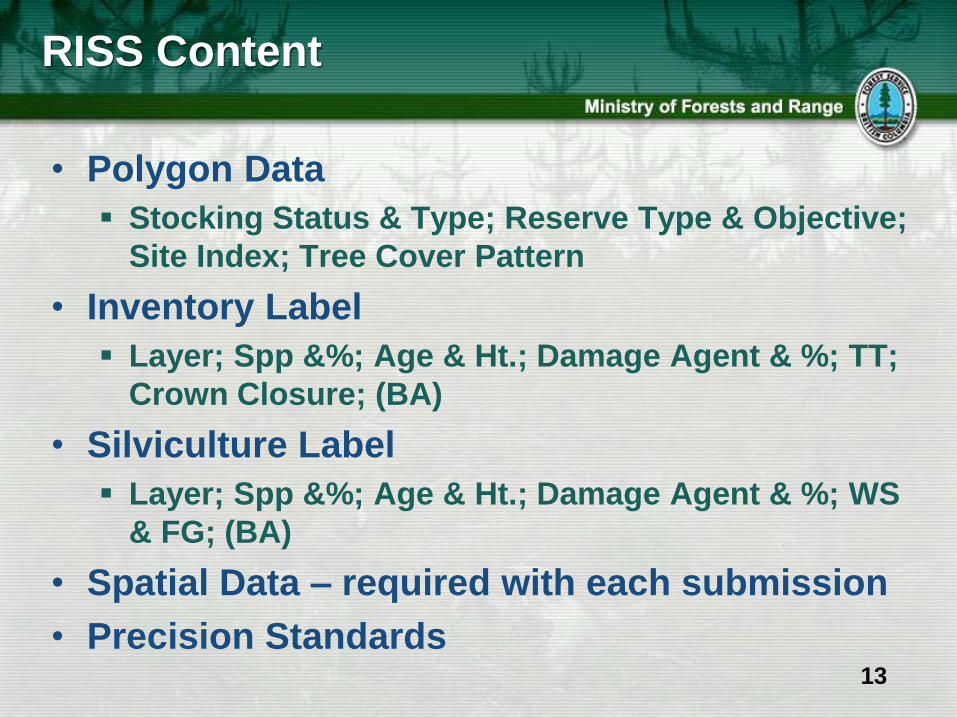
RISS Content
• Polygon Data
Stocking Status & Type; Reserve Type & Objective;
Site Index; Tree Cover Pattern
• Inventory Label
Layer; Spp &%; Age & Ht.; Damage Agent & %; TT;
Crown Closure; (BA)
• Silviculture Label
Layer; Spp &%; Age & Ht.; Damage Agent & %; WS
& FG; (BA)
• Spatial Data – required with each submission
• Precision Standards

14
Precision Standards

15
SURVEY TYPES PER
STAND STRUCTURE
Section 2

16
Complex Stand Structure ~ Surveys Manual 2010
1) CC Even-aged 2) Complex Vertical 3) Complex Horizontal
1) CC Even-aged
3 m

17
2) Complex Vertical Stand Structures
Multi-storey Uneven-aged
Layered Even-aged – Layered & Deviation from Potential (DFP)

18
2) Complex Vertical Stand Structures
Boreal Mixedwood Intimate Mixture

19
3) Complex Horizontal Stand Structures
Even-aged Clustered
Intermediate Cut – Commercial Thinning

20
3) Complex Horizontal Stand Structures
Clearcut with Reserves
Coastal & Interior Mixedwood – Patch Mixtures

21
Survey Methodology Selection Matrix
Management Regime
Even-aged stand structure Uneven-aged
stand structure
Stocking
Standard
One Layer TSS & MSS Multiple Layer
TSS & MSS
Silviculture
System
Clearcut (CC)
< 5 m2 BA Dispersed
Retention residual
stems
Dispersed Retention of
residual stems:
> 5 m2 BA and < 20 m
SIFR&NIFR / < 40 m2
CFR
Single tree
selection
> 5 m2 BA and < 20
m2 SIFR&NIFR /
< 40 m2 CFR
Survey
Methodology
Options
Standard
CC/Even-aged
Survey
Methodology
Layered Survey
Procedures
DFP related
(SEDRSS)
Mixedwood
(Dec/Conifer)NE
Interior and CFR
Multi-storey
Survey only IDF
zones or small
area based
tenures such
as Woodlots.

22
I’m confused!!!! Which survey do we
use?
Never mind, let’s just estimate the
stocking.

23
3 Types of Silviculture Surveys
1. Regeneration Delay Survey – Milestone
Well Spaced Assessment
Prove SR & achievement of obligation.
No Forest Health Acceptability Criteria.
2. Stocking Survey – Intermediate
Well Spaced Assessment
Monitor Performance anytime before FG.
Use of FG Damage Criteria optional.
3. Free Growing Survey – Milestone
Well Spaced & Free Growing Assessment
Prove FG & achievement of obligation
Use of FG Damage Criteria required.

24
Survey Objectives
• All of the 3 types of Surveys can
incorporate:
Plantability – plantable & preparable
spots.
Brushing – rating competition levels &
determining competition indexes.
Maximum Density – tally of
countable conifers (CC).
Forest Health – incidence outside of
damage hazards or focus on any
presence of a specific pest.

25
SURVEY TIMING
WELL SPACED AND FREE
GROWING DEF’N
Section 3

26
Survey Timing
Regen Delay - on or before Regen Date
Survey - any snow free time of year
- if vegetation cover – survey in spring or fall
- at time of planting with FS 704 is acceptable
Free Growing - before 20 yrs after harvest–FRPA blocks
Survey - once FG Height achieved
- between max leaf out & leaf fall
Time
Commencementof harvest
Regenerationdate
Free growingdate
Early freegrowing date*
1 Only for FPC blocks
In FSP In FSP
Height Achieved

27
Well Spaced Tree - definition
Mandatory factors are:
1.Preferred and Acceptable species as
listed in the SP, FSP or FDP.
2.Minimum Inter-Tree Distance (MITD)
from any other tree that is recorded
as a well spaced tree, as specified in
the SP, FSP or FDP.

28
Free Growing Tree & Stand - definition
Mandatory factors are:
1. Well Spaced Tree.
2. Free of Unacceptable Pest Damage. -
“healthy - FRPA sec 1”
3. Free of Unacceptable levels of
Vegetation Competition. –
“not impeded by competition - FRPA sec 1”
4. Free Growing Height achieved.
5. Stand Maximum Density (CC)
not exceeded.
6. Other Criteria in SP, FSP or FDP.

29
B. Basic Even-aged Survey Methodologies
Section 4
SAMPLING TECHNIQUES

30
Stratification - definition
“ The process of defining
and identifying
Populations with Similar
Characteristics in an
Opening”
MOST CRITICAL STEP
in Survey Process
Quality Quality
of of
Stratification Survey

31
Stratification - Objectives
Sampling precision, by delineating
homogenous populations.
Variation within each stratum surveyed,
as compared to the entire opening.
Efficiency of the survey by reducing
number of plots to achieve the
desired precision.
Reliability of the treatment
prescriptions.

32
Why Stratify ?
• What would be the total stems per ha. for the
block without stratification?
• Without stratification, do we meet the objectives
of a stocking survey (MSS 700 WS/ha)?
14 ha
SR
1200 sph
11 ha
NSR
200 sph

33
Stratification
Suggested Criteria for Stratification:
• Δ SU and/or BEC • Δ age class (>20 years)
• Δ stocking status • Δ height class (>10 m)
• Δ leading species • Δ site index (>3 m)
• Δ species composition (>20%)
• Δ treatment recommendations
• Δ from pure to species mix
(Fdc100 vs. Fdc80Hw10Cw10)
• Δ crown closure (>10%)
• Δ stand structure

34
Stratification – When and How?
When is Stratification done?
How is Stratification done?
• No specific rules – keep survey objectives in mind
and why we stratify.
• Split first and lump afterwards.
• Requires good judgement – this will come with
more experience.
1. Office
Preliminary
Stratification
2. Field
Walkthrough
“Refinement”
3. Field
During Plots
“Refinement”
4. Compilation
During Summary
“if required”

35
Case Study – example photo
Boundary
Preliminary
Stratification
Area of
uncertainty
– possible
brush?
1
1
2 3
3
2

36
Survey Design and Methodology
Survey Design is a function of:
1.Survey objective
2.Required plot intensity and desired level of
accuracy
3.Strata variability
**Remember**
A formal survey is no longer required under FRPA
(also applies to all old FPC openings).
Required only to produce an Inventory &
Silviculture Label with a declaration.

37
Survey Methods
1. Grid Sampling
Very structured • Plots often 100m x 100m
pattern, not always along
cardinal bearings
• Contract rules for PoC,
moving plots, distance from
timber edge, etc.
Suitable for:
• Strata with high variability
• Where many plots are
required
• Statistical analysis is
required

38
Survey Methods
2. Vector Sampling
Moderately structured
• Pre-determined bearings
(not usually more)
• Plot spaced evenly
along the lines
Suitable for:
• Unusually shaped
openings < 10 ha.
• Where few plots are
required
• Statistical analysis is
required
400m
@ 2
0
200m
@ 1
60
250m @ 90
142m
142m
142m
142m
142m
142m

39
Survey Methods
3. Representative Sampling
Lightly structured
• Establish plots as if “the
plot data collected
adequately represent the
conditions on the stratum”
Suitable for:
• Obvious stocking status
• Skilled Surveyors
• Very few plots are required
• Statistical analysis is
required
400m
@ 2
0
200m
@ 1
60
250m @ 90
1
2
3
**Use caution**

40
Survey Methods
3. Visual Assessments
Not structured
• Relies on surveyor
professionalism and
experience
Suitable for:
• Obvious stocking status
• Skilled Surveyors
• No formal plots are required
• Statistical analysis is not
required
**Use caution**

41
Dispersed or Mosaic Strata
SU B/C
• Two or more strata that
can be clearly defined &
described, but
impractical to map.
• May have to move plots
on a pre-defined off set
to completely sample
each strata.
• Summarize each strata,
but do not map.
A - 6 ha
B/C – 10 ha 80% B ( 8 ha)
20% C ( 2 ha)
A
B & C ?
A B/C

42
Draft Field Map

43
DATA COLLECTION
Section 5

44
Survey Parameters – Where & What?
What’s needed for FS 657?
• Preferred & Acceptable
Species.
• Target & Minimum Stocking
Standards.
• Minimum Inter-Tree Distance.
• Regen Date.
• Early & late FG Dates (FPC).
• Regen Height (Contract).
• FG Height.
• Conifer to Brush Ratio.
• Maximum Density.
• Specific Forest Health Criteria
• Any others?
Where?
•SP, FSP, and/or FDP
•RESULTS Opening file.
•Aerial Photos –
conventional, ortho., high
resolution digital.
•Forest Cover map.
•Previous silviculture
treatment prescriptions or
post treatment reports.
•Previous Surveys.
•Survey Contract Standards.
•Any others?

45
FS 660 Survey Reference Field Card
• Damage Agent Codes
• Damage Criteria –
Even-aged; Uneven-
aged; Broadleaf;
Advanced Regen
• Crown Closure Est.
• Stats Cheat Sheet
• Site Index Selection Key
• Inventory and
Silviculture Label Guide
•Steps to Complete Survey
•Stratification
•History Symbols
•Plot Conversion factors
•Tree Species Codes
•Soil Texture Key
•Appendix 9 Summary
26 pages of good stuff!!!

46
Virtual 3.99 m radius plot – Well Spaced
12 12
p a
P S
W
W W W
W
W W
6 1
M
6 1.1 0 0

47
Data Collection – Cards or Handheld?
3 Software providers currently:
•JRP Solutions – Survey Wizard
•DR Systems – Silva Star
•West Creek - SAP

48
Tally 5 313 282 228 14 6 6 4 1 9 / 3M 10 1.7 5 1 Sali ~22 2.3 DRA 5F 5FS
13 5 2 3 17 / 1M 12 2.4 Rupa ~35 1.3 DRA 3Pl
GI 4 2.5 Fdi AD 2F
IWS 1Sx

49

50
Inventory Labels = Inventory Update & TSR
A Roughly averaged species composition to the nearest 10% based on visual observations recorded on the FS 658. The leading and second species are particularly important to be correct.
B Using the FS 658 data, roughly average the age of the dominant and co-dominant leading (13 years) and then repeat for the second species (12 years).
C Using the FS 658 data, roughly average the height of the dominant and co-dominant leading species (2.4 m) and then repeat for the second species (1.4 m).
D Site index of the leading species in the label. The Fdi is predicted to be 23 m tall at 50 years after 1.3m in height is reached. I in this example indicates the method used to determine the site index is growth intercept. (see Table 30)
E Crown closure estimated by visual observation of aerial photograph. Ground observation is possible but commonly less accurate (see Table 27 a, b, c). The trees described in A and F have a crown closure of 19%.
F The average number of total trees of commercial species per hectare. 12520 total trees per hectare.
G The last 2 digits of the year the survey was conducted. 2008 = (08).

51
Silviculture Labels = Stocking Standard
Compliance
H This prefix identifies the stocking status NSR, SR or FG. Subsequently the data that follows NSR and SR represent well spaced trees and following FG represents free growing trees.
I The calculated species composition of the well-spaced trees present, recorded to the nearest 1%. Bl 36 = 36% Sub-alpine fir.
J Average age of all free growing (well-spaced) trees, 13 years.
K Average height of all free growing (well-spaced) trees, 2.5 m.
L Site index of the leading species in the label. The Bl is predicted to be 21 m tall at 50 years after 1.3m in height is reached. E in this example indicates the method used to determine the site index is SIBEC. (see Table 30)
M The average number of free growing (or well-spaced) trees per hectare. 1120 free growing trees per hectare. When the results of a free growing survey indicate that the stratum is free growing, all of the components of the label should be replaced by values representing the free growing trees.
G The last 2 digits of the year the survey was conducted. 2008 = (08).

52

53
STATISTICS
Section 6

54
Statistics - Definitions
n = number of plots established
x = sample mean or average
S = standard deviation of the mean
pm = plot multiplier
s/ha = stems per hectare
Sx = standard error or standard error of the mean
t90 = t value, found on the FS 660 table
CI = confidence interval
LCL = lower confidence limit.
MSS = minimum stocking standard
e = desired survey precision level

55
Statistical Decisions
MSS LCL
Fewer
free growing treesMore
free growing trees
X
MSSLCL
Fewer
free growing treesMore
free growing trees
X
MSSLCL
Fewer
free growing treesMore
free growing trees
X
1) Free Growing
No further plots
2) Not Free Growing
No LCL required &
no further plots
3) Not Free Growing
Within precision?
If not , further plots
required.

56
Calculation Card for Confidence Limits FS 1138A
93B023-123
A
16
5
4.6 920
0.894/2.236 = 0.400
0.894
Compare with
value on FS 659
to ensure they
are the same !!!

57
Calculation Card for Confidence Limits FS 1138A - continued
2.132
No Further Plots Required
3.747
0.853 171
749
700

58
Desired Precision or “e value”
*** MoFR will accept X if LCL < e ***
Methods of calculating e value:
1) X ≤ 1000 s/ha. e value = +/- 100 s/ha.
2) X > 1000 s/ha. e value = X x 10%
If LCL > e More plots are required to a max of 1.5 / ha.
Method of calculating the number of extra plots required:
( t2 x S2 ) / e2 = number of plots required to meet precision
(up to maximum 1.5 plot / ha. – then no stats required)

59
Additional Plot Locations
AB
A
B
Example Extra Plot Locations -

60
C. Free Growing Assessment Criteria
Section 7
APPENDIX 9
Mechanics of Quadrant System
and Allowable Broadleafs

61
Free Growing or Not? Using Appendix 9

62
Free Growing – review definition –
Appendix 9
1. Well Spaced Tree. “p&a spp. and MITD”
2. Free of Unacceptable Pest Damage. -
“healthy - FRPA sec 1”
3. Free of Unacceptable levels of
Vegetation Competition. –
“not impeded by competition - FRPA sec 1”
4. Free Growing Height achieved.
5. Stand Maximum Density (CC)
not exceeded.
6. Other Criteria in SP, FSP or FDP.

63
Free Growing Brush Competition depends on vegetation type

64
Present Guidance Choice in
Assessing Competition
1
Crop / Brush Ratio only
Crop Tree is FG if:
• Shrub & Herbs
< 100% C/B
• Broadleaf
< 150% ( or 125%) C/B
2
Appendix 9- Quadrant
Crop Tree is FG if:
• Shrub & Herbs
< 100% in
3 of 4 Quadrants
• Broadleaf
1. < 150% ( or 125%) C/B
in all 4 Quadrants
OR
2. < 150% ( or 125%) C/B
in 3 of 4 Quadrants, &
< # of Allowable
Broadleaf per plot

65
Appendix 9 – Quadrant Method

66
Unacceptable competition –
Shrub and Herb - Interior
For non-broadleaf competing vegetation:
Simple Quadrant Rule
• To be free growing, competing vegetation
within 1m of the crop tree can only be taller
in one quadrant

67
Shrub and Herb Competition (non broadleaf)
Crop tree is taller than shrub in at least 3 of 4 quadrants

68
Unacceptable Competition
Broadleaf - Interior
• If the competition within one meter of
the crop tree includes Ep, At, upland
Act, then use the process of
elimination to identify potentially free
growing trees
• PROCESS:
• 1st is it obviously not FG
• 2nd is it obviously FG
• All other scenarios are
Potentially Free Growing (PFG)

69
Broadleaf Brush Competition
Conifer
/ Brush
Ratio
Free
Growing
Not Free
Growing
Potentially
Free
Growing

70
FG Flow Chart Differences
Allowable Countable Broadleaf per plot
Interior
At, Act & Ep
Coastal
Dr, Ep & Vb

71
Potentially FG Assessment Steps
1. Determine all the potential FG trees
2. Determine the median height of the
potential FG trees
3. Count Ep, At, Act, within your 3.99m
plot that are taller than the median
height of the potential FG trees
4. Use the table to determine if the
potential FG trees are FG or not

72
Virtual 3.99 m radius plot – Free Growing
15 12 10 40
p a
P S
W
W W
W
W W
W
6 1
M
0 0
FG
FG FG
FG
3 1
4
10 1.6 At 5 3 IWW 2P
PFG
NFG NFG
NFG

73
Training and support program
Silviculture Survey Training
Opportunities
10 day and 5 day
training courses
On-going Support via MOFR staff and web pg
1 day “What’s
New”

74
Thank You and Question Period
Dave Weaver
Silviculture Performance Assessment Specialist