Baseline survey Report - Food and Agriculture Organization
47
1 Food and Agricultural Organization of the United Nations (FAO) Ministry of Agriculture (MOA) “Strengthening Disaster Preparedness in the Agricultural Sector” TCP/CPR 3105 Report of Baseline Survey and Training Needs Assessment Report writing by: Liu Yonggong, Wang Li Survey Team: Wang Xiaoli, Li Jian, Huang Yannan Gong Jun, Xu Shaobo, Chen Chongying Center for Integrated Agricultural Development-CIAD China Agricultural University Beijing 100094 October 2007
Transcript of Baseline survey Report - Food and Agriculture Organization

1
Food and Agricultural Organization of the United Nations (FAO)
Ministry of Agriculture (MOA)
“Strengthening Disaster Preparedness in the Agricultural Sector” TCP/CPR 3105
Report of Baseline Survey and Training Needs Assessment
Report writing by:
Liu Yonggong, Wang Li
Survey Team:
Wang Xiaoli, Li Jian, Huang Yannan
Gong Jun, Xu Shaobo, Chen Chongying
Center for Integrated Agricultural Development-CIAD
China Agricultural University
Beijing 100094
October 2007

2
Acknowledgement Baseline survey and institutional capacity and training need assessment is an important
activity of the TCP Project “Strengthening Disaster Preparedness of Agricultural Sector”.
During the implementation of the survey, the CIAD Survey Team received a number of
supports from Mr. Niu Xiangyong, Director of Juye Agricultural Bureau, Mr. Wang
Yansen, Deputy Director of Juye Agricultural Bureau, Mr. Zhang Fangzheng, Vice
Governor of Qilin Township, village leaders of Pilot Villages, Mr. Zhang Zhongjun,
Deputy Representative of FAO Beijing and Mr. Stephan Baas, Responsible Project
Officer of FAO Rome provided valuable proposals and comments to the survey concept
and the report. The CIAD team likes to express sincere thanks to them for their
assistances and supports.
CIAD Survey Team October 2007

3
Table of Contents
MAJOR ABBREVIATIONS AND ACRONYMS....................................................................................5
1. PROJECT BACKGROUND .................................................................................................................6
2. THE BASELINE AND TRAINING NEEDS ASSESSMENT SURVEY............................................6
3. PROCEDURE AND METHODOLOGY .............................................................................................7
3.1 PROCEDURES ......................................................................................................................................7
3.2 METHODOLOGY..................................................................................................................................8
4. MAJOR FINDINGS...............................................................................................................................8
4.1 MAJOR FINDINGS ON THE NATIONAL AND PROVINCIAL LEVEL............................................................8
4.1.1 Natural Disasters and National Policy Framework on DRM....................................................8
4.1.2 Provincial Regulations on DRM ..............................................................................................10
4.2 FINDINGS FROM THE COUNTY LEVEL................................................................................................. 11
4.2.1 Natural Resource Endowment and the Economic Features ..................................................... 11
4.2.2 Flood Disasters in the County .................................................................................................12
4.2.3 Assessment of Drainage Infrastructures in Juye County..........................................................14
4.2.4 Assessment of DRM institutional mechanism in Juye County..................................................15
4.3 FINDINGS FROM THE PILOT TOWNSHIP ..............................................................................................19
4.3.1 The Economic Features and Natural Resource Endowment ....................................................19
4.3.2 Natural Disaster and Agricultural Structure in Qilin Township ..............................................21
4.3.3 Assessment of Drainage Infrastructure in Qilin Township.......................................................22
4.4 MAJOR FINDINGS AT THE COMMUNITY AND HOUSEHOLD LEVEL........................................................23
4.4.1 Basic situation of three pilot villages.......................................................................................23
4.4.2 Change of Village Agricultural Structure for coping the flood disasters .................................30
4.4.3 Assessment of the village drainage infrastructures..................................................................31
4.5 MAJOR FINDINGS ON FARMERS’ ASSOCIATIONS ................................................................................34
4.5.1 Review of the current policy framework of Farmer’s Cooperation..........................................34
4.5.2 Situation of Farmers Cooperation in Juye County ..................................................................34
4.5.3 Farmers’ Organizations in villages..........................................................................................35
4.5.3 Training Needs of Farmers Association...................................................................................36
5. RECOMMENDATIONS FOR CAPACITY BUILDING OF FARMERS ASSOCIATION AND

4
FOLLOW-UPS .........................................................................................................................................38
5.1 CAPACITY BUILDING FOR FA............................................................................................................38
5.1.1 Capacity Building and Training...............................................................................................38
5.1.2 Recommendations for promotion of the FA Development ........................................................38
5.2 RECOMMENDATIONS FOR FOLLOW UP PROJECT ACTIVITIES ...............................................................39
5.2.1 Recommendations for ADPC follow-up ...................................................................................39
5.2.2 Follow-up for National Specialists Inputs ...............................................................................39
5.2.3 Recommendations for building partnership for institutionalizing the DRM............................40
6. ANNEX..................................................................................................................................................41
6.1 SCHEDULE OF FIELD SURVEY ............................................................................................................41
6.2 PEOPLE INTERVIEWED ......................................................................................................................42
6.3 QUESTIONNAIRES AND OUTLINE OF THE FIELD SURVEY.....................................................................43

5
Major Abbreviations and acronyms
ADPC Asia Disaster Preparedness Centre
AAPC Agriculture Action Plan for China’s Agenda 21
BS Baseline Survey
CIAD Centre for Integrated Agricultural Development
CBDRM Commu nity Based Disaster Risk Management
CDRLC County Disaster Reduction Leading Committee
DRM Disaster Risk Management
FA Farmers Association
FAO Food and Agricultural Organization of the United Nations
FC Farmers Cooperative
FO Farmers Organization
IDNDR International Decade for Natural Disaster Reduction
LOA Letter of Agreement
MOA Ministry of Agriculture
NPD National Project Director
PMO Project management office
PSC Project Steering Committee
SDPAS Strengthening Disaster Preparedness in Agricultural Sector
SDRC State Disaster Reduction Commission
TCP Technical Cooperation Program
TNA Training Needs Assessment
TOR Terms of Reference

6
1. Project Background
The Project “Strengthening Disaster Preparedness in Agricultural Sector-SDPAS” is a
technical cooperation project (TCP) launched in China in July 2007. In accordance with
China’s new policy on natural disaster prevention and public hazards and emergency
management the TCP project objective is to assist the Ministry of Agricultural-MOA and
its line agencies at provincial and local levels in testing and operationalizing on pilot basis
in Juye county Shandong Province, the process of shifting from an emergency response
focused intervention approach towards a Natural Disaster Risk Prevention/Preparedness
oriented approach in the agricultural sector. Due to the situation in Juye County, the
project will focus mainly on two types of disasters, floods (combined with water logging)
and drought. The pilot project, if successful, will offer the basis for replication in other
high-risk flood and drought prone areas of China.
The intended long-term project outcomes are to contribute to:
Reducing the economic losses of farmers to the impacts of recurrent natural
disasters and to build up their own capacities and resilience to mitigate future
impacts from natural calamities.
Reducing environmental degradation (alkalization of soils);
Enhancing the operational capacities and coordination mechanisms for risk
prevention and management at commu nity, county, prefecture and provincial
levels;
Improving of farmer’s livelihoods at the commu nity level;
2. The Baseline and Training Needs Assessment Survey
From 5 to 10 September 2007 a survey team1 was fielded to Juye County by the Center
for Integrated Agricultural Development-CIAD, China Agricultural University for
carrying out baseline and training need assessment survey.
The major objectives of this baseline survey and training needs assessment are:
To collect the solid baseline information and data on social and economic
features, local natural resource endowment, data on social and economic losses
1 The team consists of following members: Prof. Liu Yonggong, Ms. Wang Li, Mr. Li Jian, Ms. Wang
Xiaoli, Ms. Huang Yannan, Ms. Gongjun, Mr. Xu Shaobo, Ms. Chen Chongying
7
caused by the flood disasters in the pilot county, and impacts of natural disasters
on farmers livelihood and agricultural production;
To identify the current institutional mechanism and policy strategies for natural
disaster prevention/preparedness in local area. Based on the findings a
replicable model for institutional cooperation in DRM will be discussed and
primarily developed;
To analyze the current situation of farmers’ association and cooperation in the
pilot villages, to assess the training needs for the development and operation of
Farmers Association and for strengthening the functions and roles of farmers’
cooperatives and association in the Disaster Risk Management. Based on the
results of this baseline survey and TNA, the survey team will also develop the
training plan and training curriculum for the farmers association training in
October 2007;
3. Procedure and Methodology
3.1 Procedures For achieving the above-mentioned objectives, the BS and TNA field survey was
conducted in the local area according to the procedure as following:
(1) Preparation before field survey:
Review the DRM practice related to Agricultural Sector in China and Shandong
Province;
Prepare the Baseline Survey and Training Needs Assessment Framework and
outline of the survey report;
Formu late the outline and questionnaire for the field survey;
(2) Conduct Baseline Survey and Training Needs Assessment
Conduct the institutional interview and workshop with related local line
agencies in Juye County and Qilin Township;
Collect the first-hand and second-hand data and information for describing
social and economic features of pilot county and township;
Implementation of the BS and TNA in the selected three pilot villages: Yaoqiao
Village, Liuxi Village and Nancao Village;
Conduction of the participatory farmers workshop and discussion, household

8
interview and field survey in sites;
(3) Documentation of findings and writing up report
Analyzing the collected data and information;
Writing up the report;
3.2 Methodology The major methodology and methods used and applied in the BS and TNA included the
Participatory Rural Appraisal (PRA) methods and tool:
Key informant interview; Semi-structured interview;
Household interview;
Small group discussion and workshop;
Seasonal calendar for looking at the farming system and frequency and impacts
of the natural disasters;
Chronological review of the floods and other natural disasters;
Community transect walk and resource mapping;
Questionnaires;
4. Major Findings
4.1 Major findings on the National and Provincial level
4.1.1 Natural Disasters and National Policy Framework on DRM
China is one of the few countries that are most vulnerable to natural disasters. With
diversified geographical characteristics China is prone to a diversified range and frequent
occurrences of disasters affecting vast regions and incurring huge economic losses. Since
1990s, economic losses incurred by natural disasters have been rising sharply with grave
implications for economic and social development. China has been haunted by flood,
typhoon, drought, hailstorm and snowstorm, freeze, landslide, mud and rock flow and
earthquake, among other disasters.
In a normal year, the whole national population affected by and suffered from the natural
disasters is about 200 million, with thousands of death people, 3 million people must be
vacuumed from the disaster areas. And the amount of damaged farmlands and forests
land is about 40 million hectare in each normal disaster year. According to the statistic

9
data2 of the economic losses caused by disasters, the direct economic losses were
increasing in the past 50 years (based on the price index of year 1990). Chart 4-4-1
illustrates the economic losses caused by natural disasters in the past fifty years.
Chart 4-1-1 The Economic Losses caused by Natural disaters inlast 50 years in China
4857 59
69
100
0
20
40
60
80
100
120
1950s 1960s 1970s 1980s 1990s
Bill
ion
RM
B
Facing the challenges of frequent natural disasters, the central government already has
recognized the urgency and importance of establishing a disaster management system for
reducing the economic losses of natural disasters and agricultural production risks. The
Chinese government has been committed to disaster reduction all these years with strong
interventions and actions as follows:
(1) The integrated disaster reduction mechanism, institutional setup and legal
framework
Following the indications of the "International Decade for Natural Disaster Reduction"
(IDNDR) agreement by the United Nations General Assembly, the China National
Committee for IDNDR was established in 1989. It was renamed as the China
Commission for the International Disaster Reduction in 2000 and as the State Disaster
Reduction Commission (SDRC) in 2004. The SDRC has been dedicated to its functions
and missions and done a lot of commendable work in coordinating member departments
to formu late national disaster reduction strategies.
2 The Disaster Reduction Planning of People’s Republic of China (1998 to 2010)

10
In 1998 the State Council formu lated a “The Disaster Reduction Planning of the
People’s Republic of China (1998-2010)”, which was the first planning of disaster
reduction based on the Agenda 21 of China. In 2005, the “National Natural Disaster
Prevention Law” was formulated and approved. More recently, in August 2007, the State
Council of People’s Republic of China formu lated and implemented the “State’s
Eleventh Five-Year Plan for Integrated Disaster Reduction”, in order to increase the
capacity of disaster reduction from the national to the local level, prompt the
preparedness of natural disaster, and protect people’s security and livelihood. China has
instituted, promulgated and enforced 30-odd laws and regulations as it moves forward to
phase in a legal framework for disaster reduction.
(2) State disaster emergency response and contingencies system
The disaster emergency response effort in China is based on the fundamental principles of
“unified leadership, management regulated at different levels, integration between
centralization and decentralization and zonation management.” The central government
has mapped out overall emergency response plans, 25 special plans and 80 departmental
plans so far. By the end of 2004, provincial-level emergency contingencies plans have
been drawn up by 31 provinces, autonomous regions and mu nicipalities, while 310 out
of 333 municipal governments and 2,347 out of 2,861 county-level governments have
also formulated local regulations for implementing the emergency response plans at the
local level.
4.1.2 Provincial Regulations on DRM
In order to implement the national policy and programs in the local level, the provinces
always follow up with actions plan and provincial regulations to the disaster risk
management. For instance, Shandong Province, local emergency contingencies strategy
has been formulated by the provincial government in year 2006, such as “Shandong
Tenth Five-year Plan for Disaster Preparedness” issued in year 2005, and “Plan for
Emergency Relief” in year 2005 and etc. On the other hand, the Shandong Provincial
Disaster Prevention Regulation was formulated and approved in Oct. 2005. The
document is very systematic and concrete.
There is a provincial association for prevention natural disasters in Shandong province.
And the institutional structure of the DRM in Shandong province includes the Provincial
government and county government. County government acts as the head of the
11
emergency coordination committee at county level. The major members of the
committee include: meteorological bureau, agriculture, forestry, water resource,
environment, land resource, development and reform committee, finance, civil affaires,
construction bureau, transportation and communication, etc.
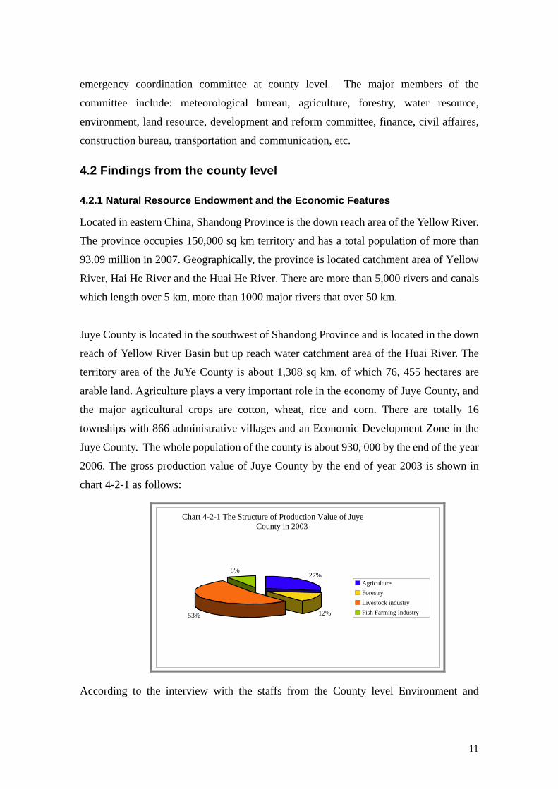
4.2 Findings from the county level
4.2.1 Natural Resource Endowment and the Economic Features
Located in eastern China, Shandong Province is the down reach area of the Yellow River.
The province occupies 150,000 sq km territory and has a total population of more than
93.09 million in 2007. Geographically, the province is located catchment area of Yellow
River, Hai He River and the Huai He River. There are more than 5,000 rivers and canals
which length over 5 km, more than 1000 major rivers that over 50 km.
Juye County is located in the southwest of Shandong Province and is located in the down
reach of Yellow River Basin but up reach water catchment area of the Huai River. The
territory area of the JuYe County is about 1,308 sq km, of which 76, 455 hectares are
arable land. Agriculture plays a very important role in the economy of Juye County, and
the major agricultural crops are cotton, wheat, rice and corn. There are totally 16
townships with 866 administrative villages and an Economic Development Zone in the
Juye County. The whole population of the county is about 930, 000 by the end of the year
2006. The gross production value of Juye County by the end of year 2003 is shown in
chart 4-2-1 as follows:
Chart 4-2-1 The Structure of Production Value of Juye County in 2003
27%
12%53%
8%
AgricultureForestryLivestock industryFish Farming Industry
According to the interview with the staffs from the County level Environment and

12
Climate Station, there are several kinds of natural disasters such as floods, droughts,
storms, pest disasters, etc. And the flood is one of the major disasters with highest
frequency and worst negative impacts on human livelihoods and agricultural production
in the county.
4.2.2 Flood Disasters in the County
(1) Lower geographical location
Juye County is located in the lowest geographical basin of a topographical depression
zone, thus rain-water from the up reach 6 counties flows into the Juye County in the rainy
season, and it is always exposed to high annual and seasonal rainfall variability, which
together make the county highly vulnerable to natural disasters like floods, strong winds
and hailstorms. In the past twenty years, the increasing natural rainfall concentrated in
July and August has resulted in frequent flood disasters and led to huge losses in the
agricultural sector and increased vulnerability to food insecurity.
(2) Natural rainfall
Annual rainfall records kept by the County Meteorological Bureau indicates that the
rainfall happens frequently in July and August, the growing period of most crops in the
area. The impacts of the floods on the major crops has been also indicated in the seasonal
calendar made during the farmers interview in the pilot villages. (as shown in follow table
4-1). The calendar shows not only the main cropping pattern but also the relationship
between seasonal rainfall threats and farming seasons in the county. It can also be seen
from the calendar, the cotton, corn and rice are the major crops that have highest risks of
flood in July, August and September every year.
According to the interview with village leaders and county officials, for example, in the
last 17 years (from 1990 to 2007), there were 4 years with large areas and serious floods
disasters and many normal heavy raining years in the local areas. That means there is one
serious flood disaster very 5 years. The following table 4-2-2 and table 4-2-3 provide the
data of the annual rainfall and monthly rainfall days in July and August in the county in
some specific years.

13
Chart 4-2-2: Annual and Monthly Rainfall of Juye Coun
0 200 400 600 800 1000 1200 1400
1990
1993
1995
1998
2000
2003
2005
Yea
r
Rainfall
Rainfall of the whole year (mm) Rainfall of July and August (mm)
Chart 4-2-3:Rain days of July and August in Juye County
0
2
4
6
8
10
12
14
16
18
20
1985 1990 1995 2000 2005
Year
JulyAugust
Following findings and conclusions can be drawn from the data indicated in the above
chart 4-2-2 and chart 4-2-3:
From year 1990 to year 2000, the amount of annual rainfall was decreasing
regularly, while after year 2000 it increased suddenly in year 2003 and kept the
average amount of rainfall by 1000 mm each year;
In the normal year, more than 60% of the whole annual rainfall in the Juye
County is concentrated in July and August;
In year 1990, year 1993, year 2003 and year 2005, the typical flooding year in
Juye County, and average annual rainfall exceeded 900 mm, and monthly
rainfall totally in July and August was also over than 500 mm; These annual and
seasonal rainfalls are already exceeded the drainage capacity of the current
drainage infrastructures;
In typical flooding year, the average rain days in July and August was about 25
14
days totally;
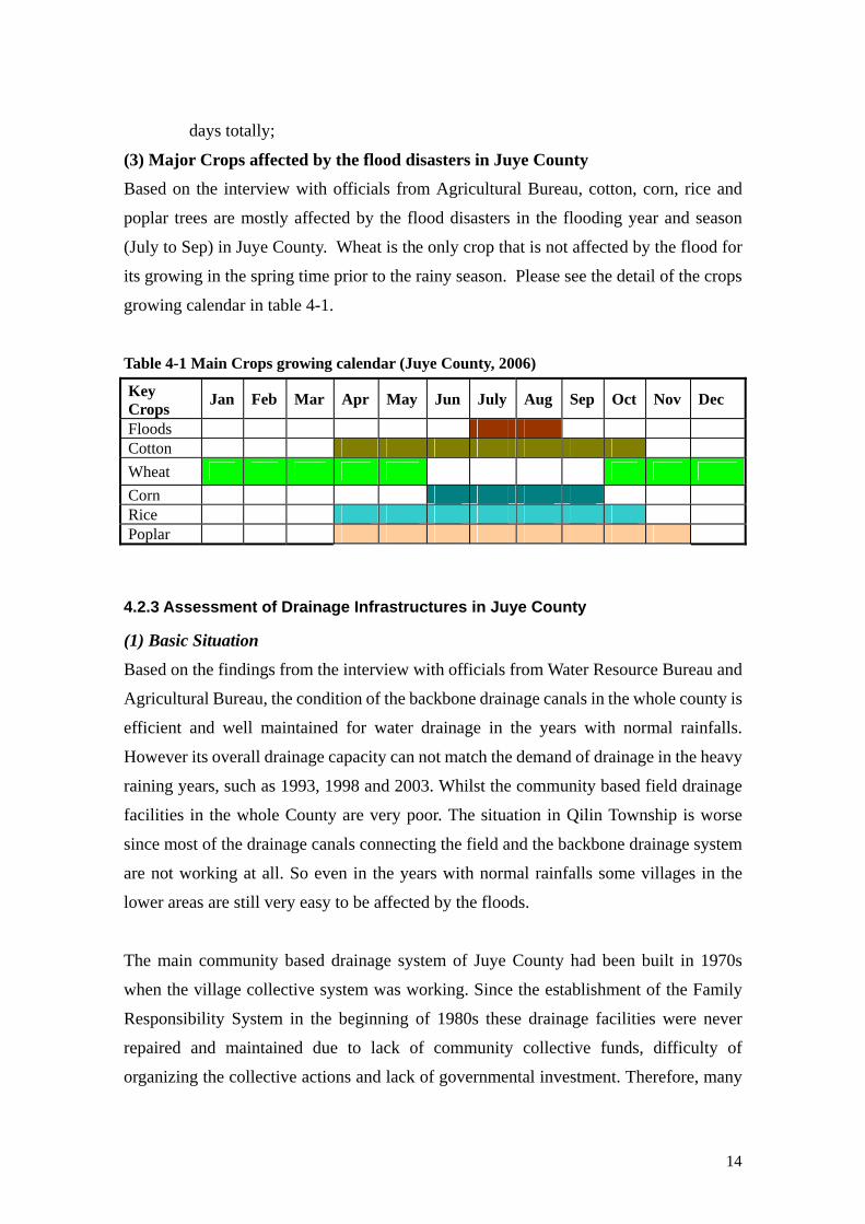
(3) Major Crops affected by the flood disasters in Juye County
Based on the interview with officials from Agricultural Bureau, cotton, corn, rice and
poplar trees are mostly affected by the flood disasters in the flooding year and season
(July to Sep) in Juye County. Wheat is the only crop that is not affected by the flood for
its growing in the spring time prior to the rainy season. Please see the detail of the crops
growing calendar in table 4-1.
Table 4-1 Main Crops growing calendar (Juye County, 2006)
Key Crops Jan Feb Mar Apr May Jun July Aug Sep Oct Nov Dec
Floods Cotton Wheat Corn Rice Poplar
4.2.3 Assessment of Drainage Infrastructures in Juye County
(1) Basic Situation
Based on the findings from the interview with officials from Water Resource Bureau and
Agricultural Bureau, the condition of the backbone drainage canals in the whole county is
efficient and well maintained for water drainage in the years with normal rainfalls.
However its overall drainage capacity can not match the demand of drainage in the heavy
raining years, such as 1993, 1998 and 2003. Whilst the community based field drainage
facilities in the whole County are very poor. The situation in Qilin Township is worse
since most of the drainage canals connecting the field and the backbone drainage system
are not working at all. So even in the years with normal rainfalls some villages in the
lower areas are still very easy to be affected by the floods.
The main community based drainage system of Juye County had been built in 1970s
when the village collective system was working. Since the establishment of the Family
Responsibility System in the beginning of 1980s these drainage facilities were never
repaired and maintained due to lack of community collective funds, difficulty of
organizing the collective actions and lack of governmental investment. Therefore, many

15
villages in the whole county suffered from the flood just because of the lack of drainage
canals and connections from the community level to the main rivers or backbone canals.
(2) Preliminary proposals for improvement community bases drainage system
For strengthening the water drainage infrastructure and facilities both at the community
and the regional level of the county the team made following proposals to be considered
by the responsible governmental line agencies and villages:
For building the commu nity anti-flood capacity, the investment for repairing or
building the village drainage network should be allocated by the government
(County Water Resource Bureau);
Village committee and existing farmer’s association should play roles in
coordinating and mobilizing the individual households participation and
contribution to the construction of the community drainage system, especially for
improving the farmland drainage canals, connection facilities for linking field
drainage network and the backbone canals;
4.2.4 Assessment of DRM institutional mechanism in Juye County
(1) The Current Situation
Through workshop and discussion with the officials from county level institutions the
survey team made some findings and observations in the institutional cooperation and
coordination mechanism in DRM:
There was already a “County level Disaster Reduction Leading Committee”
(CDRLC) and led by the county government. The major functions of CDRLC
include:
o Drawing up the disaster reduction and preparedness plan;
o Holding the disaster emergency coordination meetings;
o Organizing and coordinating the disaster emergency relief actions;
o Providing the support to the post disaster recovery and etc;
The CDRLC is headed by the vice governor of Juye County. The office of
CDRLC was established in County Water Resource Bureau;
The members of the CDRLC include: County Armed Force Department, County
Meteorological Bureau, Financial Bureau, Agricultural Bureau, Water Resource
Bureau, Civil Affairs Bureau, Health Bureau, Forest Bureau, Transportation
Bureau, Broadcasting Bureau, and all the township governments;

16
According to the interviewed officials, theoretically, all the CDRLC member
institutions more or less involve in the DRM process. However the , the major
bureaus who have significant roles and functions in the whole disaster
management cycle are:
o In early warning: meteorological bureau, agricultural bureau and
water resource3 bureau;
o In preparation of the disaster: water resource bureau, civil affaires
bureau, agricultural bureau;
o In emergency relief: all member institutions under coordination of
CDRLC;
o Rehabilitation period: agricultural bureau and agricultural extension
stations, water resource bureau, etc.; (see table 4-2)
Led by the CDRLC, we found there was little communication and interaction
between different bureaus and departments. Different departments cooperate with
each other in line with the county government’s arrangement. Interactive
coordination and cooperation mechanism is not yet established among different
departments.
The existing governmental anti-natural disaster mechanism is mainly focusing on
the emergency relief period, whilst the long term anti-disaster capacity, such as
strengthening drainage system both at region and community levels, the disaster
preparedness and post disaster rehabilitation are not sufficiently emphasized and
put into the priority of the disaster management strategy.
For the time limitation of the BS, the survey team only interviewed with major
institutions and departments of the CDRLC, which include: County Agricultural Bureau,
Water Resource Bureau, Meterological Bureau, Civil Affair Bureau, and Statistic Bureau
and Administration of Commerce and Industry (for registration of farmers’ cooperatives) .
According to the findings from the institutional interview with the above major
government units, the different roles and functions of them in the process are shown in the
table 4-2.

17
Table 4-2 Roles and functions of related institutions in DRM in Juye County Institutions Early
Warming Preparedness Emergency
Relief Recovering
Agricultural Bureau
- Transfer the hazard warming information from meteorological and Water resource bureau to local commu nity;
- Technical advise: introduce water resistant varieties change the agriculture cropping patterns, sowing time and etc;
- Prepare the production means for post disaster rehabilitation;
- Prepare the technicians for helping farmers in post disaster rehabilitation;
- Mobilization and promotion activities in the commu nities;
- Participation in the salvage operation and emergency relief in the local areas;
- Facilitate and cooperate with the other institute and organizations in the emergency relief;
- Assist farmers with the agricultural products sales after the disasters;
- Modification of the farming system to avoid or reduce the economic losses caused by floods disasters;
- Supply the information to the provincial and national government units;
Water Resource Bureau
- Involve in the disaster forecast and send out the forecast information to the other departments on county and township level;
- Plan the long term anti-disaster drainage system;
- Dredge the drainage system in local community;
- Examine, construct and repair the irrigation and drainage infrastructures;
- Prepare the material (such as plastic bags and etc.);
- Emergency action for draining out the water from the flooded farmland and houses in the field;
- Facilitate and cooperate with the other institutions and organizations in the emergency relief;
- The repairing and maintenance of the water infrastructure after the disaster;
Meteorological bureau
- Responsible for the county level data and information of climate forecast;
- Work with the water resource bureau for the potential natural disaster forecast;
- No further participation;
- Participating in the flood disaster relief
- Monitoring and evaluation of the happened disasters;
- No further participation;
Civil Affairs Bureau
- Received the disaster forecast information from the Disaster Leading Committee3;
- Set up the plan for the county level emergency relief;
- Prepare the emergency relief materials and stuffs;
- Field survey before
- Report to the provincial government of the disaster situation;
- Emergency relief: provide food, drink water,
- The statistic and collection of disaster information and situation;
3 County Level Disaster Reduction Leading Committee (CDRLC): This leading committee is based on the

18
the disaster happened;
clothes and house, health sanitation and etc service to local people in the disaster area;
Statistic Bureau
- Received the disaster forecast information from the Disaster Leading Committee;
- No further participation;
- Participating in the relief;
- No further participation;
(2) Proposed countermeasures to be taken for improving DRM in the county
Based on the above assessment of the institutional participation and cooperation in the
DRM process, some proposals for strengthening the institutional coordination,
cooperation and innovating the DRM strategy are made by the survey team:
Change of the DRM strategy. The current existing emergency relief focused
disaster management strategy should be changed to integrated disaster
management strategy. Priorities should be given to the disaster preparedness,
especially to the improvement of the community based drainage system-CBDS
The County Level Disaster Reduction Leading Committee: i) should have a
specific disaster preparedness long term plan, besides the existing emergency
relief plan, for it is important to make disaster preparedness early than relief from
the disaster after it has already happened; ii) provide more financial supports to
the related institutions and departments for the capacity improvement of disaster
preparedness and reduction;
The County Agricultural Bureau: i) should have more active involvement in the
early warming process in cooperating with the meteorological bureau and water
resource bureau for evaluation of the potential hazard lost and risks on the local
agriculture; ii) should set up the long term strategy and plan for the Disaster
preparedness and management which should include the long term strategy and
plan for changing the agricultural structure or farming system based on the
disaster happening frequency and etc; iii) should provide agricultural technology
extension services to the local farmers after the modification of the agricultural
county government level units and geared by the County governor for the Disaster warming, preparedness,
emergency relief and recovering process.

19
sowing structure;
Water Resource Bureau: i) should pay more attention to the draining facilities and
canals in the community; ii) should have long term plan of the water infrastructure
construction especially for the drainage system in community level;
County Meteorological Bureau: should include more indigenous knowledge of
the disaster or hazard especially in the community level when doing the disaster
data and information collection;
Civil Affairs Bureau: also need to pay attention to farmers’ livelihood when the
flood is over;
4.3 Findings from the pilot Township
4.3.1 The Economic Features and Natural Resource Endowment
With over 220 square kilometers territory, Qilin Township is located in northeast of Juye
County, neighboring to the Heze City and Ji’ning County. The whole population of Qilin
Township is 63, 200 with about 90% of agricultural population. There are 33,000 labor
forces, among which 16,000 are males and 17,000 females. According to the township
and village officials interviewed, more than 50% of the labors migrated to the cities,
province capital and other areas for cash income. There are totally 67 administrative
villages, 77 natural villages and 16, 065 households in the whole township.
According to the 2006 statistics, the annual average per capita income was about 4330
Yuan/year with about 1300 Yuan from agriculture, accounting for more than 30%. The
rest 70% of household income is from the livestock production, off-farm activities or
industry, working outside and etc (see the table 4-3-1 Farmers’ income structure in Qilin
Township). It can be seen from the chart, due to the high losses caused by the flood
disasters the crops production is no longer the major income source as usual for the local
population, working outside is the major income source for the local farmers.

20
Chart 4-3-1 FarmersÕ income structure in Qilin Township
30%
5%
5%10%10%
40% Agriculture
Handicraft industry
Service industry
Transportation income
Livestock Rasing
Working out
In Qilin Township, the major agricultural crops include: cotton, corn, rice and wheat.
And the change of sowing area of these crops was obvious since 1990. Chart 4-3-2 and
chart 4-3-3 illustrate the changes of different crops in reflecting the flood disasters in the
township.
Chart 4-3-2: Main crops growing area of QiLin Township
0
500
1000
1500
2000
2500
3000
3500
4000
4500
1990 1993 1995 1998 2000 2003 2006 Year
Cotton Corn Rice Wheat
Chart 4-3-3:Relation between rainfall and yield of main crops in QiLin Township
0
200
400
600
800
1000
1200
1400
1990 1993 1995 1998 2000 2003 2006 Year
Rainfall of July and August Cotton Corn Rice Wheat

21
From chart 4-3-2, 4-3-3 and flood chronological record ( refer to the “flood chronological
review of Qilin Township” in later section) one can see that since 1993, the amount of
rice sowing area increased from zero to about 1073 ha in year 2006. On the other hand,
the sowing area of wheat also increased by 1.3 times from 1998 to 2006. Since the rice
has high resistance to the floods, its sowing area and yield both increased since 2000. The
sowing areas and yield of wheat is relatively consistent since it is not much affected by
the floods since it is growing in the dry season. It can be seen from chart 4-3-3, the yield
of cotton and corn are very sensitively affected by the July-August rainfall.
4.3.2 Natural Disaster and Agricultural Structure in Qilin Township
The major natural disasters of Qilin Township include: flood, drought (mostly in the
1980s), hurricane, hailstone and plants pest and diseases. According to the interview with
township government officials, flood is the major natural disaster, which brings the most
serious economic losses, seriously affects local people’s livelihood in the whole
township.
The flood disasters mainly occur in summer season due to the concentrated rainfall in
later July, whole August and beginning of September. For example, in 1998, there was a
serious flood in July and August, and the flooded farmland is more than 50,000 mu and
the collapsed houses are over 3000. According to the statistic, there were totally 4 serious
flooding years in the past twenty years, namely 1993, 1998, 2003 and 2005, in the Qilin
Township.(see chart 4-3-3)
All these floods brought great effects on the local population. To reduce the social and
economic impacts of the flood disasters, farmers and villages, as an important reaction to
the floods, have tried to change the farming system and crop patterns. Followings are
some cases for this modification:
i) Since 1993, the year with serious flood disaster, the sowing area of rice and
wheat increased greatly in the township (please refer to the chart 4-3-2 and chart
4-3-3);
ii) In some villages, farmers started to plant poplar trees by using the farmland
which is frequently flooded in later July and August. Farmers think that poplar
trees have higher resistance to floods comparing with other crops;
iii) Some of households (innovative households) start to build up the greenhouses
for vegetable production in their farmlands in order to compensate the economic

22
losses caused by the floods.
CCaassee SSttuuddyy OOnnee The picture on the right was the poplar tree in Nancao Village. In Nancao Village 1200 mu farmland (which occupied by more than 85% of the whole farm land) had been planted with poplar since 2003, where cotton and wheat were planted before. Since the flood, farmers could gain little income from crops, because in every flood major crops such as cotton and corn would be flooded and almost no income. But poplar was not influenced by flood so much and moreover farmers could graze the sheep under high poplar, which was another income source. It is said by local farmers that the 1 mu poplar could contribute RMB 1000 income every year, which is considerable for farmers.
4.3.3 Assessment of Drainage Infrastructure in Qilin Township
((11)) TThhee SSiittuuaattiioonn
According to the township and village leaders
interviewed during the township workshop the
conditions of the drainage infrastructures and canals at
the community level are very poor and out of work since
long time. Such outdated drainage infrastructure is the
major reason for frequent floods disasters with high
economic losses.
During the meeting with the township governmental
officials, the community drainage infrastructures is mapped for Qilin Township (see
figure above). The three red lines marked the major three backbone drainage canals
which pass cross the township and the blue line was the village drainage canals, of which
the blue line was the current drainage canals which have been completed and the broken
blue line marks the drainage canals to be constructed.
Therefore the two pilot villages (Liuxi Village and Nancao Village) located in the
southern part of the township are the two villages mostly suffered from serious floods due

23
to the uncompleted drainage canals. And the interviewed township government officials
expressed that the Juye County government should take the responsibility of building and
constructing uncompleted canals to reduce the community’s vulnerability against flood
disasters.
((22)) RReeccoommmmeennddaattiioonnss ffoorr iimmpprroovveemmeenntt
Based on the above mentioned findings, the survey team made following
recommendations for improving the situation:
The township government should play an important and active role in the
organizing the construction and management of the community drainage system;
There should be a township plan for the construction and maintenance of the
infrastructure and facilities, with more specific description on the community
level construction work;
Since township government can not have financial revenue after reform of the
agricultural taxation system, funds for improving the community drainage
infrastructures should be allocated by the county water resource bureau in order
to increase the anti-flood disaster capacity of the villages in the area;
The township government should be responsible for coordinating and mobilizing
the labor inputs of villagers and assist the villages to set up a drainage
infrastructure maintenance system for long term use of these factilities.
4.4 Major findings at the community and household level
4.4.1 Basic situation of three pilot villages
((11)) YYaaooqqiiaaoo VViillllaaggee
Yaoqiao Village is located in the middle part of Qilin Township. The Zhu Shui River
passes through the village (please refer to the map of Qilin Township above). There are
totally 210 households and 743 people in this village. Among the whole population, there
are 303 labor forces with 137 males and 166 females. Every year there are about 180
people working outside for cash income.
There are totally 1128 Mu arable farmland in Yaoqiao Village with major crops of cotton,
wheat, vegetable, beans and poplar trees. The areas of each crop sown in year 2006 are
indicated in table 4-4-1, and structure of the farming system for autumn harvest is referred

24
to chart 4-4-1.
Chart 4-4-1 The Sturture of Farming system inYaoqiao Village
27%
62%
8% 3%
Poplar CottonVegetable Bean
Table 4-4-1 The Farming System in Yaoqiao Village in 2006 Farming Season and Farming Area Percentage (%) Crops
Autumn Season (Mu )
Percentage (%) Winter Season (Mu )
Percentage (%)
Cotton 700 62% - - Wheat - - 700 62% Vegetable 100 8% - - Bean 28 3% - - Poplar trees 300 27% - -
By the end of 2006, the average net income per capita in this village was 2,000 Yuan. And
major source of the income include: agricultural income, working outside income,
livestock raising and etc. Please see the income structure of Yaoqiao Village in chart
4-4-2.
Chart 4-4-2 The Farmers' income structure in Yaoqiao Village in 2006
55%35%
10%
Agricultural IncomeWorking outsideLivestock raising

25
The most serious natural disaster in Yaoqiao Village is flood and it breaks out almost
every year in this village. In early August 2007, an infrequent wind came to this village,
especially bringing very serious calamity to farmers who plant vegetables and trees.
Drought and insect also take place every three or four years;
According to group interview with local farmers, there is a great flood disaster every 10
year in Yaoqiao Village. In year 1993 and 2003, due to the heavy floods major crops
affected have lost almost 100% yields on the 1000 mu farmlands, almost 70 farmer’s
houses damaged or collapsed as a result of the flood.
Major reasons for the natural disasters happened in Yaoqiao Village are:
First of all, Yaoqiao Village is located in the lower area of the township. Therefore,
the rainfall and water from upper level villages nearby always flows to this village
and can not be drained out in a short time;
The rainfall in the area is mainly concentrated in later July, August and beginning
of September, which is very easy to lead to the serve flood disasters in certain part
of the area, especially the lowest parts;
The existing field drainage system in the village is completely out of work due to
lack of renovation and maintenance in the past twenty years. By community
resource transect walk the team found that most of the drainage facilities built in
the collective time in 1970s have been entirely collapsed.
In the family responsibility system community farmland is distributed to the
individual households. In such individual farmland management pattern it is very
difficult to organize farmers’ collective actions to improve the irrigation and
drainage system without governmental financial support.
These constraints and reasons for high vulnerability to the flood disasters have been also
identified in the other two pilot villages.
((22)) LLiiuuxxii VViillllaaggee
Liuxi Village is located in the southwest of Qilin Township, with the whole population of
1483, of which 783 are labor forces. There are totally 330 households in this village.
Among the labor forces, 400 are males and 383 are females. In Liuxi Village, there are
600 people working outside, accounting for about 77% of the total labor forces.

26
There are totally 1,500 mu arable land, with 800 mu for growing Poplar trees, 300 mu for
cotton, 300 mu for wheat, 150 mu for vegetables. The areas of each crop sowing in 2006
are shown in table 4-4-2, and structure of the farming system in autumn season is referred
to chart 4-4-3.
Chart 4-4-3 The Sturture of Farming system in Liuxi Village
53%34%
13%
Poplar CottonVegetable
Table 4-4-2 The Farming System in Liuxi Village in 2006 Farming Season and Farming Area Percentage (%) Crops
Autumn Season (Mu )
Percentage (%) Winter Season (Mu )
Percentage (%)
Cotton 500 34% - - Wheat - - 500 34% Vegetable 200 13% - - Poplar 800 53% - -
By the end of 2006, the net income per capita is 2,500 Yuan, which are mainly generated
from agriculture, working outside, livestock raising and etc. Please refer to the detail of
income structure in Liuxi Village in Chart 4-4-4.

27
Chart 4-4-4 The Farmers' income structure in Liuxi Village in 2006
50%
35%
15%
Agricultural IncomeWorking outsideLivestock raising
According to the farmers interviewed, floods almost occur every year in last five years
and cause serious economic losses. Cotton is a major cash crop that is seriously affected
by the floods every year. the annual economic losses of cotton is significant. The average
yield of cotton is about 150 kg/mu, and whole economic lost of cotton in Liuxi village is
about 150kg/mu * 300mu* 8yuan/kg = 360,000 yuan/year.
According to the village leaders, the current irrigation and drainage system in Liuxi
Village was constructed in 1973. While this system in the village can only be used for
irrigation at present, the whole drainage system is completely out of work due to lack of
the renovation and maintenance. Since 1973, the government had never invested funds to
maintain and rehabilitate the irrigation and drainage system in village.
According to the village leaders interviewed, it is difficult to organize individual farmers
to participate in the renovation of the drainage system without governmental initiative
fund investment.
Table 4-5 The chronological record of flood disasters in Liuxi Village Year Disaster Type Description July, 1993
Flood - Almost no agriculture harvest (mostly the cotton and corn), four houses collapsed;
- The county government distributes some food for each person as the subsides, and two bags of clothes for each village;
- Since 1993,some new crops such as rice, lotus and wheat were planted in the village;
July 1998
Flood - 40% reduction of crop production, 500 mu of cotton and corn had no harvest, two houses collapsed;
- The county government distributed four bags of clothes and funds to the village for purchasing two pumps for draining

28
water from the flooded land; - From 1998 to 2002,the main crop in the land was still cotton;
July 2003
Flood - 80% reduction of 1300 mu of cotton, three houses collapsed- 500 Yuan subsidy for the house-collapse family; - From 2003 to now, more than 50% of arable lands for cotton
has been replaced by poplar trees; July 2007
Flood - 40% reduction of both Poplar and Cotton production; - The growth of poplar trees also influenced by the flood and
strong wind after floods; - The county government did not provide special subsidy to the
village, the rehabilitation is mainly depending on “self-help”;
((33)) NNaannccaaoo VViillllaaggee
Nancao Village is located in the southeast of Qilin Township. The village has a total
population of 945, of which 300 are labor force. Most of the labor forces of Nancao
Village go outside and work in the cities, and the remained women and elderly at home
are responsible for the agricultural production.
There is total 1470 mu arable land in Nancao Village, of which 1200 mu have been
planted with fast-growing poplar trees after year 2003 and 270 mu for growing cotton
and winter wheat (inter-cropping). Farmers selected the poplar trees because they
recognized that the poplar trees have high resistance to the floods and need less labor
input and have a relatively higher market price. Please refer to the percentage in chart
table 4-6 and structure of the farming system in autumn season is referred to chart 4-4-5.
Chart 4-4-5 The Sturture of Farming system in Nancao Village
82%
18%
Poplar Cotton
Table 4-6 The Crop Farming System in Nancao Village in 2006

29
Farming Season and Sowing Area Percentage (%) Crops Summer Season (Mu )
Percentage (%) Winter Season (Mu )
Percentage (%)
Cotton 270 18% - - Wheat - - 270 18% Vegetable - - - - Poplar 1200 82% - - Total 1470
And the major income sources of Nancao Village include: forestry, animal husbandry and
migrant work. The average income per capital by the end of year 2006 was about 2200
yuan RMB. The floods disasters have remarkable negative economic impact on farmer’s
livelihoods since they caused big lost in agriculture production. Please see the percentage
of the income source in chart 4-4-6.
Chart 4-4-6 The Farmers' income structure in NancaoVillage in 2006
10%
80%
10%
Agricultural IncomeWorking outsideLivestock raising
Table 4-7 The chronological review of floods in Nancao Village Date Disaster Descriptions July, 1993
Severe Flood
- All 1400 mu cottons were lost in this flood, and the direct economic loss was 1.12 million RMB to the whole village.
- The main causes of this flood include: the low-lying farmland; a few days torrential rain; and the outside water from surrounding high places;
July, 1998
Severe Flood
- All 1400 mu cottons were lost in this flood, and the direct economic loss was 1 million RMB;
- The situation in 1993 was as same as the situation in 1998; Summer in 2003
Flood - 60% of the cottons were lost in this flood. - In order to alleviate the negative flood influences to farmers,
Nancao started to plant 1200 Mu fast-growing poplar sine Oct. 2003.
From 2004 till now
Flood, Insect Damage
- Due to insect damage, 30% yield of poplar were lost every year;- According to the price of poplar in 2007, the economic lost of
poplar will be RMB 300yuan/mu /year for the insect damage;

30
4.4.2 Change of Village Agricultural Structure for coping the flood disasters
((11)) CChhaannggee ooff tthhee ffaarrmmiinngg ssyysstteemm ffoorr aannttii--ddiissaasstteerrss
According to the findings from the household interview and farmer’s group discussion,
the high frequency flood disasters have caused lots of economic losses each year. In a
normal year, the loss of the agricultural income was reduced by 50%, and in severe years,
the loss of agricultural income is even more than 80%. Since there is no significant
change of the village anti-flood capacity, farmers start to change their farming system by
adjusting sowing structure in the farmland.
The major farming system changes for coping the flood disasters initiated in recent years
include:
After the severe flood in year 2003, with the technical supports from the County
Forestry Bureau, some villages start to plant the fast-growing poplar on the
farmland, which occupied more than 50% of the whole arable land in each
household;
By planting poplar trees, the family labor force inputs are significantly reduced
since the trees do not need too much labor. Therefore many young male labors can
be freed from the crop farming for working outside;
The development of the livestock raising: since there is less impacts from the
flood on the livestock raising in the community, there are some households who
have potential for investment and adopting relevant technology, start to raise the
sheep, rabbits, pigs and goose at home or in the poplar forest. Nancao Village has
shown a good example;
The development of greenhouses for vegetable production: there are some
households start to invest in the green house for producing vegetables, for
example in Yaoqiao Village;
The development of fishery industry: some households start to invest in fishery
production in the village, for example in Liuxi Village;

31
((22)) PPrrooppoossaallss ffoorr iimmpprroovveemmeenntt
Based on the findings from the baseline survey, there
are some big challenges at present after the
modification of the agricultural structure, it include:
Fast-growing poplar suffered insect damage
and strong wind after flood disaster (the
picture on the right shows the poplar trees
after a serious wind disaster in Nancao
Village) in July and August every year;
The pest for the poplar trees. Since the poplar plantation is designed in a
mono-variety without diversified species, it is very sensitive against pest
attractions which are mostly occurring after the flood disasters.
For there is no funds and technical supports from outside, only small part of the
local farmers (normally the rich farmers) started the modification of agricultural
structure;
For the insect and disease of the poplar, local farmers are afraid of the extension of
the poplar in large scale;
4.4.3 Assessment of the village drainage infrastructures
The picture on the right shows the cotton field flooded in August 2007 in Liuxi Village.
The water in the land could not be drained out, and the cottons were soaked in the water
for months after the flood and then died. According to the on-site survey there were at
least 300 mu flooded farmlands as shown in the picture
taken in Liuxi Village. However these floods and losses
could be alleviated if farmers dredge the drainage canals
before the raining season or even when the rainwater is
flooding the farmland.
((11)) SSiittuuaattiioonn aannaallyyssiiss
Based on the field survey, there are some problems and constraints existing in the local
drainage system at the community level:
Lack of the field drainage network at the community level

32
Based on the field survey in the community level,
there was no efficient field drainage network in the
community level. And the major connections to the
backbone canals in the community are not
established. The current connections in the
community do not work any more. (Please refer to
the picture of the connections to backbone on the left
in Nancao Village).
The limited drainage capacity due to lack of dredging existing canals
Based on the interview with villagers and field survey, the current drainage canals are in
low efficiency of use especially in the flood season:
- In terms of the backbone canals, they are sufficient for draining out the floodwater
in the normal raining years; while in the flooding year, even the local backbone
canals are not sufficient to drain out the floodwater from the community canals.
(For the time limitation, the survey team did not survey the backbone canals in the
local community);
- Through field survey and investigation in the pilot villages, the team found that
the current canals in the field are simply digged on the farmland, but not lined by
concrete bricks, therefore, over years they are easily slited up by mud and
obstacled by weeds, grasses and wastes (see the picture of the land drainage canal
in Yaoqiao Village on above right).
- In all three pilot villages, the field drainage networks are not well connected with
the backbone canals although the distance between field drainage network and
backbone canals is only couple hundred meters. That why the rainfall water is
mostly stagnated within the farmland, it is so called the “Internal Floods”.
Lack of the drainage culvert between canals and under roads on the farmland
In the early 1970s there were culverts for connecting the
drainage canals and under the roads, while after the
establishment of family-based contracted responsibility
system, farmlands were distributed and managed by each
household, farmers filled and leveled up the drainage

33
canals in order to increase the area of their own farmlands. The field roads become the
check dams for keeping the water in the field.
((22)) MMaajjoorr rreeaassoonnss ffoorr ppoooorr ccoonnddiittiioonnss ooff vviillllaaggee ddrraaiinnaaggee ssyysstteemm
The major reasons for the under development of drainage system in community level
include:
Lack of governmental funds and investments for improving the drainage system
at community level
According to the interview with the township and village leaders, there were no funds and
investments from the provincial or county government for improving the village drainage
infrastructures since 1980s. The funds from the government are focus on the backbone
canals, but not on the community canals.
Lack of collective mechanism at the community level
Before 2003, there was the fund collection mechanism in the community level. It was
very easy for the village leaders to collect the funds and/or organize the labors in the
community. While after the “Country’s Rural Taxation System Reform” in year 2003, the
collective funds collection system was abolished, and thus the village committees do not
have any funds to invest in the maintenance or repairing of the drainage facilities.
Lack of farmer’s cooperative action for DRM within the village
When flood happened, the farmers whose farmlands are on the higher places and will not
suffer from the flood were not willing to dig the drainage canals because it would reduce
the area of their farmland and cause their time. But the drainage channel only works when
the whole drainage line is repaired, so if there is just one household who dig and dredge
the drainage canals in his or her farmland, the drainage facilities will not work and all
farmlands will suffer from the disaster.
Lack of incentives for individual farmers to improve the drainage
infrastructures
After the drainage canals failure of several years, the local farmers believe that “if the
neighbor farmland will not dig and dredge the drainage canals, the only channel in my
land will be useless.” Consequently, no farmers will contribute to rehabilitating the
drainage canals, and all farmers suffer from the floods and lose cottons every year.

34
On the other hand, the young labor forces are working outside, and the whole family is
not dependent on the agricultural income any more comparing with before. And the
individual farmers do not have too much incentive for the improving of the drainage
canals although there will be the loss of the agricultural products every year.
4.5 Major findings on Farmers’ Associations
4.5.1 Review of the current policy framework of Farmer’s Cooperation
After the rural reform since 1982, farmer’s associations in China are mainly
product-based and jointly formed by farmers who are producing the same products, such
as vegetables, fruit trees, pigs and chickens, etc. However, the “farmers’ cooperative
philosophy and principles” are not introduced in the missions and regulations of these
associations. Therefore, farmers’ associations are registered by the Civil Affaires Bureau
with a legal status of a kind of NGO in rural China.
Since July 2007, the “Farmers Professional Cooperative Law of People’s Republic of
China” was approved by Standing Committee of the 10th National People's Congress,
which provided a legal foundation for establishment of Farmer’s Cooperatives-FC.
According to the law, the major regulation on registration, membership, legal obligation,
and financial principle are specifically prescribed in the law. And the Farmers’
Cooperative is legally defined as the formal economic entity for small farmers.
In the last two decades, the function of farmers’ cooperation under the family
responsibility system was very weak. And farmers’ cooperation was a very sensitive issue
in China’s rural area due to the negative experience made from the collective times from
1956 to 1982. Farmers are very sensitive against any kind of cooperative actions.
4.5.2 Situation of Farmers Cooperation in Juye County
According to the interview with the officials from the County Civil Affairs Bureau, there
were already 17 agricultural related Farmers Associations from the whole county that
registered as NGO or “civil association” in the County Civil Affairs Bureau. It is
encouraged to transform the existing farmers associations to “Farmers’ Cooperatives”
(FC) through registering by the Administration of Industry and Commerce at the county

35
level after the implementation of the law.
Based on the findings from the interview with officials from County Industry and
Commerce Bureau who is legally designated to be responsible for registration of farmers
cooperative after implementation of the law, no formal cooperatives have been registered
until now in Juye County. The major problems with the development of Farmers
cooperative in the local area include:
The concept of FC is very new to farmers in local area;
There are not enough promotion and encouragement for the FC from the local
government;
The functions, regulations, memberships and management of FC are very
unfamiliar to the local farmers;
Sometimes, farmers can not figure out the difference among the Farmers
organization, farmers association and farmer cooperatives;
There is no good model or demonstration of the FC that local farmers can learn
from;
4.5.3 Farmers’ Organizations in villages
During the field survey in the three pilot villages, the survey team also paid more
attention to the situation of the current Farmers organizations and/or farmers associations
as well as their training needs assessment in the three villages.
Based on the interview with village leaders, farmers and members of the current farmers
associations, there are some important findings and conclusions that include:
Three farmers associations registered in the County Civil Affairs Bureau in
August, 2007, which include:
- Greenhouse Farmers Association with 52 member households (25% of
whole households) in Yaoqiao Village;
- Fishery Farmers Association with 36 member households (11% of
whole households) in Liuxi Village;
- Livestock Raising (in poplar forest) Farmers Association with 48
member households (18% of whole households) in Nancao Village;
Before the registration of the farmers association, the households who have the
green house, raise the livestock and raise the marine products in each village

36
stay together and act as the informal farmers organizations for purchasing of the
raw materials, trying the new species and technology, selling the products
together and etc;
After the registration, there are no changes of the functions and operation of the
former farmers organization, for there are no formal regulations, membership,
administration and management introduced to the current farmers associations
in the three villages;
The local farmers, even the staffs from the township government and village
committee have little knowledge and ideas of the operation of Farmers
Association; And some farmers in the village even don’t know if there is the
farmers association in their village or not;
The township government has not played an active role on the training,
monitoring, extension and promotion of the farmers association in the local
area;
There are significant needs of training from the local community and staffs from
the township and village committee on the farmers association and further
farmers cooperative; (Please refer to the detail contents of training needs
assessment in the later section);
Before and after the registration of the farmer associations, there were no
participation and involvement of the farmers association in the community
natural disaster management;
4.5.3 Training Needs of Farmers Association
According to the training needs assessment among the three pilot villages with the local
farmers, there are some training needs identified by the survey team to process the
capacity building of the local farmers associations. The major contents of the training
needs are as following:
Basic Principles of Farmers Association (FA)
o Standards, registration procedure and criteria of FA;
o Roles, functions, regulations, administrative management and financial
management of FA;
o Memberships development of FA;
o Responsibility and legal rights of FA leaders and members;
o Technology service system and mechanism of FA;

37
o FA based whole sale marketing and inputs purchase and further income
earning activities;
o Operation of FA, such as “Company+ FA+ Households” operation model;
o Demonstration of good model of FA;
o Other important issues;
Future Development of Farmers Cooperative (FC)
o What’s the difference between the FA and FC?
o How to transform the FA to FC based on the current legal framework;
o Study on the “Farmers Professional Cooperative Law of People’s Republic of
China” and “Administrative Regulation on the Registration of Farmers’
Professional Cooperatives ”
o Standards, registration procedure and criteria for establishing FC;
o Roles, functions, regulations, administrative management and financial
management of FC;
o Memberships development of FC;
o Responsibility and legal rights of FC leaders and members;
o Technology service system and mechanism of FC;
o Demonstration of good model of FC;
Roles and functions of FA/FC in CBDRM
o Basic Awareness Raising on Disaster Risk Prevention and Mitigation in
community level;
o Potential role of FA/FC in disaster prevention and preparedness and
adaptation options in the agricultural sector, such as disease prevention and
etc;
o Village level planning and implementation of self selected joint activities of
DRM in local community;

38
5. Recommendations for Capacity Building of Farmers Association
and Follow-ups
5.1 Capacity Building for FA
5.1.1 Capacity Building and Training
In order to improve the capacity of the FA and the development of their functions in the
community based DRM in these pilot villages, it is very necessary to conduct the training
courses to qualify local farmers and leaders of the FC based on the needs assessed in this
survey.
The survey team made following recommendations for the capacity building and training
of FA:
The target groups of capacity building and training include not only the local
farmers but also the staffs from the township government and village
committee;
In the process of training activities, the female farmers should have the equal
opportunity to participate and join;
It is also strongly recommended that after the training to the FA member
households, the trained village leaders and farmers need to hold a FA/FC
promotion and follow up meeting based on the major training contents and
transfer the knowledge and skills for development of FA/FC to the other farmers
who have not attend the training in the same village, in order to encourage the
other farmers to join the FA/FC in future development;
Capacity building is a long process for the local farmers. It is recommended that
local township government should conduct the monitoring and evaluation with
guidelines and assistance from CIAD regularly to the local FA/FC in the coming
months or years period;
5.1.2 Recommendations for promotion of the FA Development
Besides the capacity building and training to the FA/FC, there should be more supports
from the outside in order to strengthen the capacity of FA/FC in community development

39
and natural disaster management. Following recommendations are made by the survey
team according to the findings:
First of all, in order to encourage the poor population in the community to join
the FA/FC and improve their livelihood by investing in income earning
activities, there should be some loan or credits from the bank or other national
and international organizations to cover the initiative investment;
With the development of the FA/FC, the local governmental line agencies, such
as Agricultural Bureau, Water Resource Bureau, Forestry Bureau, etc., should
provide technical services, market information to the local farmers regularly;
Preferential taxation policy and financial supports will be provided by the local
government in the initiative period of the FC.
5.2 Recommendations for follow up project activities
5.2.1 Recommendations for ADPC follow-up
The above findings from the baseline and TNA can be used for the designing the Capacity
Building framework of the Farmers Organizations. Baseline data and information
collected from this baseline survey can be used by ADPC specialist while designing the
DRM framework and institutional cooperation model. However, the baseline survey
teams has not carried out the institutional training needs assessment, so institutional
capacity and training need assessment should be carried out by ADPC. The TNA should
focus on following institutions:
County Water Resource Bureau;
County Meteorological Bureau;
County Agricultural Bureau and its affiliated extension services and sections;
County Civil Affaires Bureau;
County Planning and Reform Commission;
5.2.2 Follow-up for National Specialists Inputs
According to findings from the household interview and village survey, there are strong
needs on technical assistance and expertise, such as agronomists for crops cultivation,
vegetable and cash crops cultivation, water and irrigation, drainage infrastructure

40
specialists, forest and silvicultural sepecialists. The expertise should be mainly provided
by national consultants..
5.2.3 Recommendations for building partnership for institutionalizing the DRM
In order to ensure the sustainability and institutionalization of the disaster risk
management mechanism at different levels, the different stakeholders should have their
roles and functions in DRM. Following table show the institutional famework for DRM.
Table 5-1: Institutional Roles and Relationships for sustainable DRM in Juye County Community Local level
organization (Local government unit and
/or NGO)
National Organizations
International Organizations
Awareness and positive behavior;
Participation; Coping structure; Livelihood; Community
organization or associations;
Disaster reactions and measures;
Local short term and long term Planning;
Good governance;
Transparency; Networks; Local hazard
monitoring and evaluation;
Risk management;
National approach;
Early warming system;
Policy and implementation;
Finance;
Environment, development Programmes;
Financial and technical support;
Strategy policy;

41
6. Annex
6.1 Schedule of field survey Date Activities Location Description 1st-4th, Sep. Set up the survey team;
Review of the project framework and document, TOR;
Design the institutional interview outline and structure;
Design the outline for the farmers interview and group discussion;
Produce the outline for the findings report;
Prepare the survey material;
Beijing Pro. Liu yonggong; Ms. Wang Li; Other 5 Msc. Candidate students;
5th,Sep. Travel from Beijing to Juye County
Juye County The survey team;NPD
6th, Sep. Institutional interview with the Qilin Township government:
Basic situation of the Qilin pilot township;
The current progress of the FC registration and operation;
The major constraints and problems in the DRM and community participation;
The selection of the three pilot villages;
Juye County The survey team;County PMO; NPD; Township Government;
7th, Sep. Institutional interview with the county governmental line agencies:
Institutional cooperation and mechanism for the DRM;
Major constraints and needs with the major bureaus and stations;
Juye County The survey team;County PMO; NPD;
8th, Sep
The village survey and TNA carried out in parallel in the three pilot village, and the survey will separate into three small survey teams:
Basic situation of the DR in the pilot village;
FC development plans; Community participation in the
DRM;
Juye County The survey team;County PMO; NPD; Township Government; Farmers;
9th, Sep.
Report to the county PMO and NPD on the findings and survey results; - Back to Beijing
Juye County The survey team;County PMO; NPD; Township Government;
10th to 16th, Reporting Beijing The survey team

42
Sep.
6.2 People Interviewed 1. Meeting with Juye County Agricultural Bureau
Time: 2007/09/06, 9.00 am to 12.00 am Name Position Phone Wang Yansen Vice director of Agricultural bureau 13305405805 Wang Ningshen Vice chief of Plants Protection Station 15990931967 Yan Qingzhu Director of Agricultural and livestock
Service Center 13508987858
Li Shoumin Chief of Agricultural technical extension station
13001798548
Han Xiangbin Chief of Production and Information Division
8053158
Xu Fuhua Vice Chief of Production and Information Division
8060669
Ouyang Demin Chief of Vegetable Division 13905409871 Li Fulai Chief of Economic management station 13061556639 Li Baojin Chief of Land and fertilize station 13854067663
Note: All these above divisions and stations are below to the County Agricultural Bureau.
2. Meeting with related institutions in Juye County
Time: 2007/09/06, 2.30 pm to 5.00 pm Name Position Phone Yang Kong’an County Water Resource Bureau 13705306677 Wang Yuguo County Environment and climate bureau 13854004436 Liu Yanzhun County Civil Affairs Bureau 13583035865
Yang Guangqi County statistic bureau 8051208
Zhang Bailiang County industry and commerce bureau 13508900159
3. Meeting with Qilin Township government
Time: 2007/09/07, 9.30 am to 12.00am Name Position Phone Zhang fangzheng Vice governor of Qilin Township 13583032899 Zhou Yan Chief of Economic management station 13854004073

43
Wang Guangju Vice assistant for Civil affairs 12954051817
6.3 Questionnaires and outline of the field survey Part I. institution discussion
1. County Bureau of Agriculture interview(in the morning of the first day)
Population and nature resources;
Development of industry(agriculture, industry, Third Industry and so on );
Basic situation of natural disasters in the county: main categories of nature disasters,
main region where disasters always break out(towns, villages and so on),time rule,
the occurrence of natural disasters in the past 50 years and the loses;
The negative impacts of natural disasters on the development of agricultural
production ,data and cases;
The measures which Bureau of Agriculture has taken to reduce the negative impacts
of natural disasters on the development of agricultural production
The development of farmer association, including: the type of farmer association,
registration, development, management and the establishment of the system of
supervision.
2. Main questions and syllabus of group discussion of County institutions (in the
afternoon of the first day)
the major institutional linkages and cooperation model in disaster preventing and
reducing at this stage; institution mapping;
the situation of the existing system of disaster preventing and reducing; roles that
correlative institutions have played in the system of disaster preventing and
reducing;
the advantages of the existing institutional linkages and cooperation model,and the
major problems when it was operated in communities;
whether there is the system of disaster preventing and reducing in communities, and
the effect;
The function of rural communities in disaster preventing and reducing; what are the
potential of their participation and the level of their participation?
How to promote the establishment of the institutional cooperation system in the
system of disaster preventing and reducing within the scope of the county?

44
3. Qilin Township government agencies Interview (on the second day)
Colleting the social and economic data of Qilin Township:population,labor forces
(male and female forces),the number of households,the number of administrative
villages,the statistic data of industry development in 2006 (agriculture, industry,
outgoing working,characteristics industry and so on), nature resources (soil,
grassplot, paddy field),major sources of farmers’ economy income(sources,
proportion and classification);
Crop sowing structure and the sowing areas of major crops of the whole township;
The occurrence of natural disasters(the types, the areas of damaged land/houses、
primary months of disasters,probability of disasters,the occurrence of natural
disasters in the past 50 years);
The negative impacts of natural disasters on the development of agricultural
production and farmers’ production and life, as well as the major aspects;
The major defensive measures when suffering disasters, participants and the major
process and flow;
Evaluation on the existing system of disaster preventing and reducing;
Understandings of communities’ participating in the system of disaster preventing
and reducing; whether it is needed or not and the reasons; how to promote
communities to participate in the system of disaster preventing and reducing better?
The situation about three program Pilot Villages, Selection criteria, geographical
distribution of Pilot Village;
Farmers association :development of farmers association in Qilin Township ,the
number of farmers association, the types (such as crops production association,
Manual Industry Association;(emphasizing on poor people, the women’s status in
association, participation and voices);
Registration, management, supervision and assistance;
How to make use of farmers association to enhance the function of communities,
association and farmers,advices and ideas about the participation of farmers
association in disasters;
Training needs assessment of workers in Qilin Township(Secretary, the cadres,
director of women federation and so on);
o Training needs assessment on establishing the community-based system of

45
disaster preventing and reducing
o Training needs assessment on managing and guiding farmers association.
Part II. Village survey (Village chiefs and village secretary)-(on the third day)
1. Survey on social and economic status of three pilot villages(data of 2006)
Population,labor forces(male/female),the number of people engaged in agricultural
production, the number of people going out for work ;
The number of natural villages,the number of households;
Soil areas (easily affected area / non-affected area)
Crops sowing structure, types of crops, crop acreage (easily affected area /
non-affected area), crop yield;
Per capita income (2006); Farmers revenue structure;
2. The occurrence of natural disasters in the village
The main type of disaster, the month of disaster occurrence, the frequency of disaster
occurrence;
The main harm of natural disasters bring and the main vulnerable groups
The measure and action the village take to prevent the natural disasters.
The losses and harms to agriculture and the measure the village takes
The contact and cooperate with the outside to reduce the losses disasters bring;
3. Farmers association
The number of farmers who join the association in the pilot village (the number of
household, the poor household, the middling household and the rich household), the
type of the association;
The future development program of the farmers association
How to make farmers association play some roles in the disaster prevention and
reduction in the community to reduce the losses and harm disasters bring
4. Training needs of the village leaders (the mayor, secretary, women officer of the
village)
what trainings are included to improve the lead ability in the community after the
disasters happened;

46
The training needs of the farmers association;
Part III. Group interviews of the farmers association (emphasize the participation of
poor household and the women)
1. Community resource map
Community resource map(emphasize the distribution of agricultural plants and the
distribution of areas disasters happened);
Participatory drawing (large white paper, color pencil ) and take photos of the course;
Showing out the resource map;
2. The awareness of natural disasters in the community
The occurrence of natural disasters in farmers’ eyes;
The suggestion about how to prevent and reduce the losses the disasters bring;
The appraisal of the local government in the disaster prevention and how to improve
(such as introduce new crop which can fight drought or waterlogged);
The awareness and appraisal to the disasters prevention system of the village;
3. Farmers associations (participatory group interviews)
The awareness of farmers to associations;
The farmers associations which had been built and the future development plan(such
as building planter association);
The development program of the association and analyse and make sequence using
SWOT measure;
Whether to build farmers associations to build some mechanism and promote the
participation and effect of the disaster prevention in the community and what’s the
good suggestion and ideas;
3. Training needs of farmers association
The trainings arms to related problems of association (such as building and
registration)
The trainings arms to how to promote the disaster prevention (such as building the
farmers association in type of grouping);

47
Part IV. Individual household interview (poor household, households hit by the disaster
often, middling household and rich household)
1. The choice of household type
Make sure the standard: family’s economic situation (poor household ,middling
household and rich household); the household which join the association; households
that often hit by the disasters /households not hit by the disasters
Choose three households random in each type of household, that is (3+2+2) types *2
households =14 households per village
2. Syllabus of household interview (participatory household interview)
Give clear indication of different type of households and embody different ideas of
different households (such as poor and rich household, household hit and not hit by
the disasters)
The basic situation of the family: the number of members, the area of the land (hit
land and not hit land), work out, income sources and amount (the average income),
and so on;
The relationship with the natural disasters: the most infection from the disasters and
the quantity of losses by the disasters to the family every year;
The suggestion about how to prevent and reduce the losses of disasters bring;
The appraisal of local government during the work of disaster prevention and how to
improve (such as introduce new crop which can fight drought or waterlogged);
Farmers associations: whether they have joined the associations, why to join or not
join, the awareness and expectation of the associations;
How should the farmers associations do to improve community and households to
play roles in disasters prevention and reduction;