Baseline assessment of groundwater characteristics in the ...
27
1 Project Order Proforma 2018 1. Short Project Title Baseline assessment of groundwater characteristics in the Beetaloo Sub-basin, NT Long Project Title Monitoring of geochemical and isotopic characteristics of groundwater in aquifers in the Beetaloo Sub-basin GISERA Project Number W.16 Proposed Start Date 3 October 2018 Proposed End Date 30 June 2019 Project Leader Paul Wilkes 2. GISERA Region Queensland New South Wales Northern Territory South Australia Western Australia Victoria 3. GISERA Research Program Water Research GHG Research Social & Economic Research Biodiversity Research Agricultural Land Management Research Health Research
Transcript of Baseline assessment of groundwater characteristics in the ...

1
Project Order Proforma 2018
1. Short Project Title
Baseline assessment of groundwater characteristics in the Beetaloo Sub-basin, NT
Long Project Title Monitoring of geochemical and isotopic characteristics of groundwater in aquifers in the Beetaloo Sub-basin
GISERA Project Number W.16
Proposed Start Date 3 October 2018
Proposed End Date 30 June 2019
Project Leader Paul Wilkes
2. GISERA Region
Queensland New South Wales Northern Territory
South Australia Western Australia Victoria
3. GISERA Research Program
Water Research GHG Research Social & Economic Research
Biodiversity Research Agricultural Land Management Research
Health Research

2
4. Project Summary
Objectives
The Northern Territory (NT) community have concerns about potential impacts of the developing onshore gas industry on the quality and quantity of groundwater resources that are important to agriculture, tourism and community water supplies. These concerns were recorded in submissions to the NT Government ‘Scientific Inquiry into Hydraulic Fracturing in the Northern Territory’ and form part of the recommendations in the Final Report. A baseline characterization of aquifers expected to be intersected during the gas well drilling development is required to better understand the water systems, help address these concerns and meet recommendations of the Inquiry.
This proposed project has four objectives for better understanding of groundwater characteristics of the important aquifers in the Beetaloo Sub-basin:
1. Extend baseline groundwater characterization of important aquifers of the Beetaloo Sub-basin.
2. Identify groundwater velocity, recharge rate and source of recharge of the Cambrian Limestone aquifer (see diagram below)
3. Undertake background measurement of dissolved methane and methane isotopes, Total Recoverable Hydrocarbons (C6 – C40), Phenols, Polycyclic Aromatic Hydrocarbons (PAH) and benzene, toluene, ethylbenzene, xylenes and naphthalene (BTEXN) in water from these aquifers. This includes 41 hydrocarbon compounds as shown in Table 1.
4. Alpha and beta radiation measurements which are related to Uranium and Thorium and their decay series. Note that Uranium is also measured geochemically in this proposed project.

3
Figure 1: Map of Cambrian Limestone Aquifers (the Cambrian Limestone Aquifer system is the major aquifer in the Wiso, Georgina and Daly Basins) with the region of the Beetaloo Sub-basin included.
This project will provide important information to the community and regulators of the baseline indicators for these compounds in aquifers of the Beetaloo Sub-basin by CSIRO in a way that is transparent and available to the public. The outcomes of this project (both geochemistry and isotopic work) will also assist the NT Government in development of Water Allocation Plans that will be required should any exploration or production go ahead by industry. This proposal is the first stage of a larger baseline water project that will acquire data over a larger region in order to build a comprehensive set of baseline measurements in this region.
Region of Beetaloo Sub-basin

4
The proposed project lists five tasks as described in sections 6 and 7 of this proposal:
1. Comprehensive groundwater sampling campaign for geochemical analysis
2. Comprehensive groundwater sampling campaign for environmental tracer study
3. Selection of locations for nested multi-screen NT government funded observation wells
4. Undertake groundwater analysis for water quality assessment
5. Estimation of groundwater recharge and flow velocity through environmental tracer study It is proposed to do all the fieldwork in Tasks 1 and 2 in October and November 2018, but it should be noted that some of the results from Tasks 2 and 5 will be obtained up until June 2019 due to the long lead time in getting measurements done in New Zealand. The only other available lab in the southern hemisphere is in Australia but has longer timeframes. Results from Tasks 1 and 3 should be available within 6 months from start of project. Outputs from all five tasks are listed in sections 6 and 7 of this proposal.
Description
The Beetaloo Sub-basin is highly prospective for shale and tight gas and offers significant potential for the development of these resources. This development requires stimulation methods involving fracturing of gas-bearing, low permeability strata. There are several activities associated with onshore gas development that can potentially lead to changes in water quality as well as water levels. The Scientific Inquiry into Hydraulic Fracturing in the Northern Territory in their final report (2018) has concluded that for the Beetaloo Sub-basin, there is a lack of baseline data required to facilitate strategic environmental (water and air) and land-use assessment as well as being able to fully inform issues associated with social impacts, human health, and Aboriginal people and their culture.
Specifically, the Scientific Inquiry Final Report requires in Recommendation 7.8 that:
‘Measures to be mandated to ensure any onshore shale gas development does not cause unacceptable local drawdown of aquifers, including that the extraction of water from water bores to supply water for hydraulic fracturing be prohibited within at least 1 km of existing or proposed groundwater bores (that are used for domestic or stock use) unless hydrogeological investigations and groundwater modelling indicate that a different distance is appropriate, relevant water allocation plans (WAPs) include provisions that adequately control both the rate and volume of water extraction and that gas companies be required to monitor drawdown in local water supply bores and immediately rectify any problems if the drawdown is found to be excessive.’ Groundwater characteristics data for the Beetaloo Sub-basin are currently poorly available in public groundwater databases. The Scientific Inquiry into Hydraulic Fracturing in the Northern Territory final report recommends that before any further production approvals are granted, a regional water assessment with a

5
focus on surface and groundwater quality and quantity (recharge and flow) be conducted for any prospective shale gas basin, commencing with the Beetaloo Sub-basin. While this project will provide this information for communities both in the Beetaloo region and the NT more broadly, it will also establish appropriate monitoring tools for use by the NT Government in assessing impacts that the Shale gas industry may have on water resources in the Beetaloo Sub-basin, NT.
Other recommendations will also be considered including recommendation 7.11 which looks at actions that minimise the risk of groundwater contamination from leaky gas wells.
Need & Scope
In this study, variations in recharge rates, recharge mechanisms, and groundwater flow directions in the Cambrian Limestone Aquifer (CLA) will be evaluated using an environmental tracer survey. As per an initial pilot study, samples will be collected along hypothesized groundwater flow paths overlapping the leases in which the industry will potentially be operating. Data collected during the survey will be combined with existing tracer information, including Geoscience Australia’s (GA) ‘Exploring for the Future’ program. Because of some of the characteristics of the CLA (large system, suspected compartmentalization of groundwater flow, presence of karst features, climate and vegetation gradients) success for the tracer approach will require collecting the maximum number of samples possible, including via complementary research initiatives such as those by GA. The outcomes of this project will provide scientific data to supplement and underpin the engagement process with the community that will be undertaken as part of CSIRO GISERA’s stakeholder engagement activities.
Methodology
Reports by Fulton and Knapton (2015) and Rachakonda et al. (2018) provide a summary of current understanding of the geology, hydrogeology and groundwater characteristics of the Beetaloo Sub-basin and can help provide a contextual statement for the area, as defined by the Bioregional Assessment methodology. Using the Rachakonda et al. (2018) report as the starting point, the proposed project will consist of four activities. The use of environmental tracers in the Beetaloo Sub-basin has been documented by Suckow et al (2018).
1. Groundwater characterisation through monitoring of groundwater geochemistry of selected bores within the area shown in Figure 2 of this proposal. These bores will be selected in collaboration with the participating gas companies and may include some bores outside the current tenements
2. Groundwater sampling at selected bores located in these areas, to measure the concentration of dissolved methane (and its isotopic composition), major and minor ions, dissolved metals and other constituents of groundwater.

6
3. Groundwater monitoring of selected bores in the area (defined in point 1.) to evaluate the horizontal groundwater velocity, recharge rate and source of recharge by sampling groundwater along a hypothesised flow-path of the CLA of the Beetaloo Sub-basin.
4. To acquire chemical data for rain events, possibly from a site at Katherine. The research team would also consider engaging a local person to collect water samples from rain events during the survey period.
The NT Government is also proposing to drill a number of nested multi-screen observation wells in the Beetaloo Sub-basin to help characterize the CLA. This project will provide advice to the NT Government to help the selection of suitable locations for these proposed wells. Sampling from these wells will also be undertaken where a suitable quality of water is obtained. The development of a nested piezometer network in the CLA and other geological formations from Beetaloo Sub-basin is an important development to help assess connectivity between geological formations and the presence of alternative water supplies at depths throughout the aquifer.
A brief description of the specific tasks within these project activities is discussed in the following subsections with specific deliverables detailed in Section 7.
Groundwater sampling for water quality assessment
This activity corresponds to Task 4 of the Workflow described below. The main objective of this activity is to bring together what is currently known about groundwater levels as well as groundwater quality in the central region of the Beetaloo sub-basin and to undertake a groundwater sampling program to improve existing knowledge. The project will provide baseline information that is relevant to understand the characteristics of groundwater, which may be impacted by any gas development should it occur. As part of this activity, it is proposed to extend potentiometric head profile information provided in the Rachakonda et al. (2018) report.
The information obtained in this project may be used by the NT Government to develop detailed conceptual models of groundwater and surface water for use to inform Water Allocation Plans. This information could also be used to assist in the impact analysis and risk analysis for any exploration or production activity by industry.

7
Figure 2: Map showing location of potential bores to be sampled in this project.

8
Workflow
1. Identification and development of a groundwater sampling plan for approximately 25 bores managed by the NT Government, private landholders and gas companies located within the study area defined above, provided that the CSIRO project field team can get access to them. The team will also sample bores outside the company lease areas. The project team aims to sample any water bore that they determine to be of benefit to the study considering the location, depth and quality of water in the bores for sampling
2. Conducting a 2018 groundwater sampling campaign for the targeted bores, which includes collecting/measuring:
a. water levels
b. water quality parameters such as pH, temperature, conductivity, dissolved oxygen and redox potential
c. water sampling for physical chemistry and other water quality parameters as prescribed in Table 1
d. water sampling for dissolved methane concentration as per methodology described in Walker and Mallants (2014) report.
e. alpha and beta measurements
f. environmental tracers
3. Interpretation and analysis of monitoring data for:
a. assessment of groundwater levels relative to AHD, groundwater flow directions and, where possible, rates of flow
b. characterisation of the physical chemistry of the water resources sampled
c. establishment of baseline levels of water quality parameters in groundwater
d. determination of any exceedances of relevant guidelines
4. Development of potentiometric head and salinity profiles based on data obtained from DENR HYDSTRA, companies and groundwater sampling campaigns for key aquifers in and around the permit areas
5. Development of dissolved methane concentration profiles based on the data obtained during the 2018 groundwater sampling campaign.
The bore locations and access issues will be decided in consultation with the NT Government and landholders with assistance from industry ground teams.
9
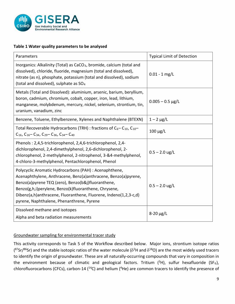
Table 1 Water quality parameters to be analysed
Parameters Typical Limit of Detection
Inorganics: Alkalinity (Total) as CaCO3, bromide, calcium (total and dissolved), chloride, fluoride, magnesium (total and dissolved), nitrate (as n), phosphate, potassium (total and dissolved), sodium (total and dissolved), sulphate as SO4
0.01 - 1 mg/L
Metals (Total and Dissolved): aluminium, arsenic, barium, beryllium, boron, cadmium, chromium, cobalt, copper, iron, lead, lithium, manganese, molybdenum, mercury, nickel, selenium, strontium, tin, uranium, vanadium, zinc
0.005 – 0.5 µg/L
Benzene, Toluene, Ethylbenzene, Xylenes and Naphthalene (BTEXN) 1 – 2 µg/L
Total Recoverable Hydrocarbons (TRH) : fractions of C6– C10, C10– C16, C16– C34, C29– C36, C34– C40
100 µg/L
Phenols : 2,4,5-trichlorophenol, 2,4,6-trichlorophenol, 2,4-dichlorophenol, 2,4-dimethylphenol, 2,6-dichlorophenol, 2-chlorophenol, 2-methylphenol, 2-nitrophenol, 3-&4-methylphenol, 4-chloro-3-methylphenol, Pentachlorophenol, Phenol
0.5 – 2.0 ug/L
Polycyclic Aromatic Hydrocarbons (PAH) : Acenaphthene, Acenaphthylene, Anthracene, Benz(a)anthracene, Benzo(a)pyrene, Benzo(a)pyrene TEQ (zero), Benzo(b&j)fluoranthene, Benzo(g,h,i)perylene, Benzo(k)fluoranthene, Chrysene, Dibenz(a,h)anthracene, Fluoranthene, Fluorene, Indeno(1,2,3-c,d) pyrene, Naphthalene, Phenanthrene, Pyrene
0.5 – 2.0 ug/L
Dissolved methane and isotopes
Alpha and beta radiation measurements 8-20 µg/L
Groundwater sampling for environmental tracer study
This activity corresponds to Task 5 of the Workflow described below. Major ions, strontium isotope ratios (87Sr/86Sr) and the stable isotopic ratios of the water molecule (δ2H and δ18O) are the most widely used tracers to identify the origin of groundwater. These are all naturally-occurring compounds that vary in composition in the environment because of climatic and geological factors. Tritium (3H), sulfur hexafluoride (SF6), chlorofluorocarbons (CFCs), carbon-14 (14C) and helium (4He) are common tracers to identify the presence of

10
either ‘young’ (>50 years; 3H, CFCs, and SF6), ‘old’ (14C; 1000 – 10,000 years), or ‘very old’ (>20,000 years and no age limit; 4He) groundwater. These can be used as age-dating tools because their concentrations vary in a predictable fashion over time in the environment. Variations in noble gas concentrations (neon, argon, krypton and xenon) in groundwater can be used to infer recharge processes, either via the inference of recharge temperature or its ‘excess air’ content (a measure of gradual vs. rapid rising water tables during recharge events).
The objectives of the tracer work are to evaluate the horizontal groundwater velocity, the recharge rate and the source of recharge by sampling groundwater at selected bores intersecting the CLA of the Beetaloo Sub-basin. A suite of environmental tracers will be sampled in up to 25 piezometers or wells. If nested piezometers are available, these will be used as possible priority sampling sites to further evaluate recharge rates (i.e., vertical groundwater velocities). Bore selection will be made in consultation with the NT Government, and landholders with assistance from industry ground teams, with a particular need to select bores with narrow screen intervals wherever possible. Pilot environmental tracer results observed during the 2017 project in the Beetaloo Sub-basin, will be used for selecting the best tracers to use in this survey. Geoscience Australia, as part of their Exploring for the Future Program, will also be sampling bores in the eastern part of this region and this project will liaise with GA to obtain access to these samples.
Workflow
1. Identification of up to 25 suitable bores located within the area between Daly Waters and Newcastle Waters to the west of the Stuart Highway, and between the Carpentaria Highway and Elliot to the east of the Stuart Highway. These regions will coincide with company permit areas. The team will also sample bores outside the company lease areas. The bore locations will be finalised in consultation with the NT Government and landholders with assistance from company ground teams.
2. Conducting groundwater sampling campaign as part of environmental tracer survey at the targeted bores, which may include collecting water samples for analysis of stable isotopic ratios of the water molecule, tritium, sulfur hexafluoride (SF6), chlorofluorocarbons (CFCs), carbon-14 (14C), helium (4He), strontium isotope ratios (87Sr/86Sr) and noble gases.
3. Interpretation and analysis of monitoring data for:
a. preliminary estimation of horizontal groundwater velocity along flow paths
b. evaluation of potential recharge sources.

11
Selection of observation well location
NT Government (as part of addressing recommendations of the Scientific Inquiry into Hydraulic Fracturing in the Northern Territory) is planning to drill at least one nested multi-screened observation well in the Beetaloo Sub-basin to assist characterisation of the CLA. NT Government in co-ordination with CSIRO GISERA will assist with the selection of suitable locations for these wells. The objective of this activity is to advise the NT Government on possible locations based on baseline groundwater characteristics and isotopic results observed as part of previous CSIRO studies in the Beetaloo Sub-basin. Another objective is to collect water samples for groundwater characterisation, once suitable quality water flows from the well(s).

12
5. Project Inputs
Research
Activities and pathways that can trigger potential for groundwater drawdown and related risks in onshore gas development areas have been identified in past studies around the world. Recent studies undertaken by CSIRO (Rachakonda et al. 2018) and others (URS, 2014; Fulton and Knapton, 2015; GHD, 2016) provide an excellent foundation for hydrogeological and water quality characteristic analyses. In the 2018 project, we will review these studies, and when appropriate, select the relevant scenarios for a groundwater quality analysis that is based on the knowledge acquired from the past studies in conjunction with our own spatial analyses of groundwater vulnerability. We will build on previous datasets owned by the NT Government and gas companies (where available) to assist with assessing potential of impacts of shale gas development on water sources that are used by the community and other water users.
Resources and collaborations
Researcher Time Commitment (project as a whole)
Principle area of expertise Years of
experience Organisation
Paul Wilkes 20 days Geophysics and energy sources 40 CSIRO Alf Larcher 27 days Chemical Analysis 25 CSIRO Praveen Kumar Rachakonda 15 days Hydrogeology and Groundwater modelling 10 CSIRO Axel Suckow 73 days Multi environmental tracer data interpretation and modelling 30 CSIRO Charles Heath 25 days Field technician 5 CSIRO Sebastien Lamontagne 21 days Environmental tracers 25 CSIRO Dirk Mallants 5 days Groundwater modelling and methane analysis 25 + CSIRO Alec Deslandes 20 days Multi environmental tracer data analysis 5+ CSIRO
Subcontractors (clause 9.5(a)(i)) Principle area of expertise ALS laboratories BTEXN and TRH analysis ANSTO or GNS NZ Lab Isotopic Analysis

13
Budget Summary
Source of Cash Contributions 2017/18 2018/19 2019/20 % of Cash Contribution Total GISERA - $377,199.00 - 75% $377,199.00
- Federal Government - $125,733.00 - 25% $125,733.00
- NT Government - $125,733.00 - 25% $125,733.00
- Origin Energy - $62,866.50 - 12.5% $62,866.50
- Santos - $62,866.50 - 12.5 $62,866.50
Total Cash Contributions - $377,199.00 - 75% $377,199.00
Source of In-Kind Contribution 2017/18 2018/19 2019/20 % of In kind Contribution Total
CSIRO - $125,733.00 - 25% $125,733.00
Total In-Kind Contribution - $125,733.00 - 25% $125,733.00
Cultural Monitoring Program
The cultural monitor program is considered mutually beneficial, increases engagement and participation of the local traditional owners and provides additional safeguards against the research proponent or other fieldworkers inadvertently entering into a sacred site or other culturally sensitive area. Cultural monitors are engaged via the NLC whenever a company or operator goes out in the field.
In GISERA projects where CSIRO researchers are being escorted onto leases by company representatives who have organised permit access, those company procedures will apply.
For all other GISERA projects (particularly environmental and social projects) where CSIRO researchers are not being escorted by industry, CSIRO will work with the NLC to apply this practice.
14
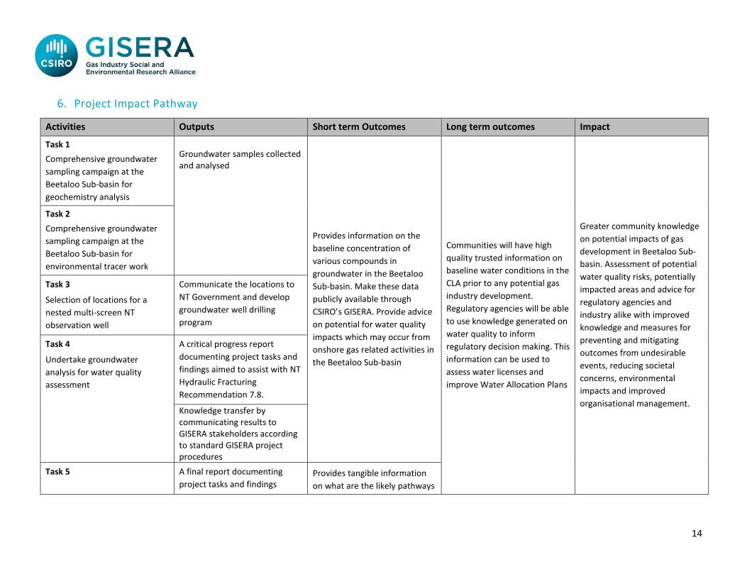
6. Project Impact Pathway
Activities Outputs Short term Outcomes Long term outcomes Impact
Task 1 Comprehensive groundwater sampling campaign at the Beetaloo Sub-basin for geochemistry analysis
Groundwater samples collected and analysed
Provides information on the baseline concentration of various compounds in groundwater in the Beetaloo Sub-basin. Make these data publicly available through CSIRO’s GISERA. Provide advice on potential for water quality impacts which may occur from onshore gas related activities in the Beetaloo Sub-basin
Communities will have high quality trusted information on baseline water conditions in the CLA prior to any potential gas industry development. Regulatory agencies will be able to use knowledge generated on water quality to inform regulatory decision making. This information can be used to assess water licenses and improve Water Allocation Plans
Greater community knowledge on potential impacts of gas development in Beetaloo Sub-basin. Assessment of potential water quality risks, potentially impacted areas and advice for regulatory agencies and industry alike with improved knowledge and measures for preventing and mitigating outcomes from undesirable events, reducing societal concerns, environmental impacts and improved organisational management.
Task 2 Comprehensive groundwater sampling campaign at the Beetaloo Sub-basin for environmental tracer work
Task 3
Selection of locations for a nested multi-screen NT observation well
Communicate the locations to NT Government and develop groundwater well drilling program
Task 4
Undertake groundwater analysis for water quality assessment
A critical progress report documenting project tasks and findings aimed to assist with NT Hydraulic Fracturing Recommendation 7.8.
Knowledge transfer by communicating results to GISERA stakeholders according to standard GISERA project procedures
Task 5 A final report documenting project tasks and findings
Provides tangible information on what are the likely pathways

15
Estimation of groundwater recharge and age through environmental tracer study
A database consists of geochemical and environmental tracer datasets
for the water recharge as well as any potential pathways for groundwater connection between different aquifers in the Beetaloo Sub-basin
Knowledge Transfer by communicating results to GISERA stakeholders according to standard GISERA project procedures including workshops

16
7. Project Plan
Project Schedule
ID Activities / Task Title
Task Leader Scheduled Start Scheduled Finish Predecessor
Task 1 Comprehensive groundwater sampling campaign for geochemistry analysis
Alf Larcher/Praveen Kumar Rachakonda
07/10/18 30/11/18 N/A
Task 2 Comprehensive groundwater sampling campaign for environmental tracer study
Axel Suckow 07/10/18 30/11/18 N/A
Task 3 Selection of locations for a nested multi-screen NT observation well
Paul Wilkes/Praveen Kumar Rachakonda/Axel Suckow
03/10/18 30/11/18 N/A
Task 4 Undertake groundwater analysis for water quality assessment
Paul Wilkes/Praveen Kumar Rachakonda
01/11/18 28/02/19 Task 1
Task 5 Estimation of groundwater recharge and flow velocity through environmental tracer study
Axel Suckow/Sebastien Lamontagne/ Paul Wilkes
03/10/18 30/06/19 Task 2

17
Task description
Task 1 TASK NAME: Comprehensive groundwater sampling campaign for geochemical analysis TASK LEADER: Alf Larcher/Praveen Kumar Rachakonda OVERALL TIMEFRAME: October - November 2018 BACKGROUND: This task involves developing a groundwater sampling methodology for identified geochemical parameters at selected sites and execution of sampling program. Sampling sites will be decided in consultation with the NT Government and landholders with assistance from company ground teams. TASK OBJECTIVES: To collect representative groundwater samples for geochemistry, dissolved methane and other hydrocarbon compounds. TASK OUTPUTS AND SPECIFIC DELIVERABLES: Report documenting the groundwater sampling program including methodologies employed, number of samples collected and analyses. Task 2 TASK NAME: Comprehensive groundwater sampling campaign for environmental tracer study TASK LEADER: Axel Suckow OVERALL TIMEFRAME: October – November 2018 BACKGROUND: Develop protocols for sampling of formation water during drilling, and sampling groundwater. Discussion with companies for selection of bores and decide on which environmental tracers to measure (i.e. those likely to be suitable for groundwater ages and likely to give differentiation between different aquifers) TASK OBJECTIVES: To collect representative groundwater samples for environmental tracer work using methodologies identified in the previous 2017 project in the Beetaloo Sub-basin. TASK OUTPUTS AND SPECIFIC DELIVERABLES: Report documenting the groundwater sampling program including methodologies employed, number of samples collected and results.

18
Task 3 TASK NAME: Selection of locations for a nested multi-screen NT observation well TASK LEADER: Paul Wilkes/Praveen Kumar Rachakonda/Axel Suckow OVERALL TIMEFRAME: October – November 2018 BACKGROUND: Discussions with NTG and companies TASK OBJECTIVES: Provide advice to NTG about possible locations TASK OUTPUTS AND SPECIFIC DELIVERABLES: Short report Task 4
TASK NAME: Undertake groundwater analysis for water quality assessment
TASK LEADER: Paul Wilkes/Praveen Kumar Rachakonda OVERALL TIMEFRAME: November 2018 – February 2019 BACKGROUND: The water samples collected during the field sampling campaign will be analysed for a range of geochemical measurements. The data will be included in a data report. A large quantity of field and analytical data will be generated during the study and these will be interpreted and reported. TASK OBJECTIVES: To analyse the water for a range of chemical constituents (see Table 1) and report the water quality data. To prepare a comprehensive report on the study and to communicate outcomes of the study to stakeholders (industry, government and community). The draft final report will undergo peer review by external reviewers. In this task the reviewer’s comments will be addressed, and the final report produced. In addition, stakeholder engagement and a Knowledge Transfer Session will be undertaken to communicate the study findings. TASK OUTPUTS AND SPECIFIC DELIVERABLES: A detailed data report describing the concentrations of various chemical constituents present in the water samples collected during the field sampling campaign. This will include quality assurance data. A final, externally peer reviewed report on water quality at the study sites. Stakeholder engagement will enhance knowledge transfer. The completion of this Task enables input into the NT government response to Recommendation 7.8 that any onshore shale gas development does not cause unacceptable local drawdown of aquifers. This task therefore is to deliver a report on the quantity of dissolved methane, methane isotopes and other dissolved compounds including: Total Recoverable Hydrocarbons (TRH) C6-C40, Phenols, Polycyclic Aromatic hydrocarbons (PAH)s and BTEXN (benzene, toluene, ethylbenzene, xylenes and naphthalene). A draft report will commence after the first field trip and expanded on after each subsequent field trip. This ‘living’ draft report will be made available to the NT government during the period November 2018 to January 2019. A final version will be finished by February 2019.

19
Task 5 TASK NAME: Estimation of groundwater recharge and flow velocity through environmental tracer study
TASK LEADER: Axel Suckow/Sebastien Lamontagne
OVERALL TIMEFRAME: October 2018 – June 2019 BACKGROUND: The water samples collected during the field sampling campaign will be analysed for a range of environmental tracers to determine the time scales of groundwater flow measurements and recharge sources. The data will be included in a data report. A large quantity of field and analytical data will be generated during the study and these will be interpreted and reported. TASK OBJECTIVES: To analyse the water for a range of environmental tracer and report the data. To prepare a comprehensive report on the study and to communicate outcomes of the study to stakeholders (industry, government and community). The draft final report will undergo peer review by external reviewers. In this task the reviewer’s comments will be addressed, and the final report produced. In addition, stakeholder engagement and a Knowledge Transfer Session will be undertaken to communicate the study findings. TASK OUTPUTS AND SPECIFIC DELIVERABLES: A detailed data report describing the concentrations/isotopic ratios of various environmental present in the water samples collected during the field sampling campaign. This will include quality assurance data. A final, externally peer reviewed report on environmental tracer at the study sites. This task is to deliver on the age distribution function (from tracer work) and the flow dynamics of the CLA for incorporation into GW model development activities. Stakeholder engagement will enhance knowledge transfer.

20
Project Gantt Chart
Task Task Description Task Leader
FY 2018-19
Oct
Nov
Dec
Jan
Feb
Mar
Apr
May
June
1 Comprehensive groundwater sampling campaign for geochemistry analysis
Alf Larcher/Praveen Kumar Rachakonda
2 Comprehensive groundwater sampling campaign for environmental tracer study
Axel Suckow
3 Selection of locations for a nested multi-screen NT observation well
Paul Wilkes/ Praveen Kumar Rachakonda/ Axel Suckow
4 Undertake groundwater analysis for water quality assessment
Paul Wilkes/ Praveen Kumar Rachakonda
5 Estimation of groundwater recharge and flow velocity through environmental tracer study
Axel Suckow/ Sebastien Lamontagne/ Paul Wilkes

21
8. Technical Reference Group
The Technical reference group will comprise three members yet to be determined: • A member of NT government (e.g., Department of Environment Water and Natural Resources)
• An academic with experience in groundwater and onshore gas research
• An industry representative with local knowledge of Beetaloo Sub-basin, NT
9. Communications Plan
Stakeholder Objective Channel
Timeframe
Government and Industry
To facilitate a deeper understanding of research findings and implications for policy, programs, planning, and other initiatives
Knowledge transfer sessions and through stakeholder workshops and meetings.
From commencement of project and with updates as they come to hand.
Regional Community/Wider public
To communicate project objectives and key messages from the research
Fact sheets (including development of one at commencement of project which will explain the objective of the project – this will be updated periodically as project progresses).
Project progress reported on GISERA website to ensure transparency for all
From commencement of project and with updates as they come to hand.
As required.

22
stakeholders including regional communities.
Participation in roadshows, community workshops and meetings and other engagements where appropriate.
Maps and visuals - Key findings communicated with the use of maps and visual cues incorporated.
As required
Towards completion
Traditional Owner communities
To pursue relations with Traditional Owner communities (via cultural monitors)
Engagement with TO communities – as a wider context as part of CSIRO communications (considered mutually beneficial)
Ongoing
Scientific community To communicate scientific findings
Journal publication At completion

23
10. Budget Summary
Expenditure 2017/18 2018/19 2019/20 Total
Labour - $278,488 - $278,488
Operating - $154,752 - $154,752
Subcontractors - $69,692 - $69,692
Total Expenditure - $502,932 - $502,932
Expenditure per Task 2017/18 2018/19 2019/20 Total
Task 1 - $85,809 - $85,809
Task 2 - $77,892 - $77,892
Task 3 - $12,352 - $12,352
Task 4 - $61,719 - $61,719
Task 5 - $265,160 - $265,160
Total Expenditure - $502,932 - $502,932
Source of Cash Contributions 2017/18 2018/19 2019/20 Total
Federal Government (25%) - $125,733.00 - $125,733.00
NT Government (25%) - $125,733.00 - $125,733.00
Origin Energy (12.5%) - $62,866.50 - $62,866.50
Santos (12.5%) - $62,866.50 - $62,866.50
Total Cash Contributions - $377,199.00 - $377,199.00

24
In-Kind Contribution from 2017/18 2018/19 2019/20 Total
Partners
CSIRO (25%) - $125,733.00 - $125,733.00
Total In-Kind Contribution from Partners - $125,733.00 - $125,733.00
Total funding over all years Percentage of Total Budget
Federal Government Investment $125,733.00 25%
NT Government Investment $125,733.00 25%
Origin Energy Investment $62,866.50 12.5%
Santos Investment $62,866.50 12.5%
CSIRO Investment $125,733.00 25%
TOTAL $502,932.00

25
Task Milestone Number
Milestone Description Funded by Start Date
(dd-mm-yy) Delivery Date
(dd-mm-yy) Fiscal Year Completed
Payment $
(excluding CSIRO contribution)
Task 1 1.1 Comprehensive groundwater sampling campaign for geochemistry analysis
GISERA 07/10/18 30/11/18 2018/19 $64,356.75
Task 2 2.1 Comprehensive groundwater sampling campaign for environmental tracer study
GISERA 07/10/18 30/11/18 2018/19 $58,419.00
Task 3 3.1 Selection of locations for a nested multi-screen NT observation well
GISERA 03/10/18 30/11/18 2018/19 $9,264.00
Task 4 4.1 Undertake groundwater analysis for water quality assessment
GISERA 01/11/18 28/02/19 2018/19 $46,289.25
Task 5 5.1 Estimation of groundwater recharge and age through environmental tracer study
GISERA 03/10/18 30/06/19 2018/19 $198,870.00

26
11. Intellectual Property and Confidentiality
Background IP (clause 11.1, 11.2)
Party Description of Background IP
Restrictions on use (if any)
Value
$
$
Ownership of Non-Derivative IP (clause 12.3)
CSIRO
Confidentiality of Project Results (clause 15.6)
Project Results are not confidential.
Additional Commercialisation requirements (clause 13.1)
Not Applicable
Distribution of Commercialisation Income
(clause 13.4)
Not applicable
Commercialisation Interest (clause 1.1)
Party Commercialisation Interest
CSIRO Not Applicable
Origin Not Applicable
Santos Not Applicable

27
12. References
Barrett DJ, Couch CA, Metcalfe DJ, Lytton L, Adhikary DP and Schmidt RK (2013) Methodology for bioregional assessments of the impacts of coal seam gas and coal mining development on water resources. A report prepared for the Independent Expert Scientific Committee on Coal Seam Gas and Large Coal Mining Development through the Department of the Environment. Department of the Environment, Australia.
Fulton S and Knapton A (2015) Beetaloo Basin Hydrogeological Assessment. CloudGMS, Australia. GHD (2016) Groundwater Overlying the Beetaloo Sub-basin Explanatory Report. Northern Territory Government Department of Land Resource Management, Darwin, Australia. <https://frackinginquiry.nt.gov.au/submission-library?a=456121>.
Rachakonda PK, Wilkes P, Larcher A, Hortle A, Barrett D, Horner N and Woltering M (2018) Groundwater Baseline Assessment of Beetaloo Basin, Northern Territory. Draft Report for Origin and Santos, CSIRO Report Number EP182563, 46pp. Scientific Inquiry into Hydraulic Fracturing in the Northern Territory (2018) Final Report of the Northern Territory Hydraulic Fracturing Taskforce, Darwin, Australia. https://frackinginquiry.nt.gov.au/inquiry-reports/?a=494286 Suckow A, Deslandes A, Gerber C and Lamontagne S (2018) Environmental Tracers in the Beetaloo Sub-basin. CSIRO Report Number EP186868, 50 pp. URS (2014) McArthur Basin Baseline Hydrological Reviews EP-161, EP-162, EP-189. McArthur Basin Baseline Hydrogeological Review and EP-161 Sampling and Analysis Plan. Report prepared for Santos Limited, Australia. Report No: 42214016/R001/D
Walker GR and Mallants D (2014) Methodologies for investigating gas in water bores and links to coal seam development, Project report prepared by the Commonwealth Scientific and Industrial Research Organisation (CSIRO) for the Queensland Department of Natural Resources and Mines, Australia, 64 pp.