Barnsley Local Plan Submission Version December 2016 · 3 the Local Plan are: Special Protection...
48
Transcript of Barnsley Local Plan Submission Version December 2016 · 3 the Local Plan are: Special Protection...

1
Barnsley Local Plan Submission Version December 2016
Habitats Regulations Assessment
1.0 Introduction
1.1 Articles 6(3) and 6(4) of the Habitats Directive require Habitats Regulations Assessment (HRA) to be carried out for plans and projects that are likely to affect a Natura 2000 site. These sites include Special Areas of Conservation (SAC), Special Protection Areas (SPA) or a Ramsar Site. HRA is a process which evaluates the effects of plans on the conservation objectives of the sites and determines whether the plans will affect the integrity of these objectives. The Stages of Habitats Regulations Assessment (HRA) are1:
Stage Task Outcome
Stage 1: Screening Identify Natura 2000 sites and their conservation objectives Describe the plan. Identify potential effects on Natura 2000 sites Assess the effects on Natura 2000 sites
Where effects are unlikely prepare a finding of no significant effect report. Where effects judged likely or lack of information to prove otherwise proceed to stage 2.
Stage 2: Appropriate Assessment (AA)
Gather information (plan and Natura 2000 sites) Predict impacts Evaluate impacts in view of conservation objectives Where impacts considered to affect qualifying features, identify alternative options Assess alternative options. If no alternatives exist, define and evaluated mitigation measures where necessary
Appropriate Assessment report describing the plan, Natura 2000 site baseline conditions, the adverse effects on the Natura 2000 site, how these effects will be avoided through firstly avoidance and secondly mitigation, including the mechanism and timescale for these mitigation measures. If effects remain after all alternatives and mitigation measures have been considered proceed to stage 3.
Stage 3: Assessment where no alternatives exist and adverse impacts remain taking into account mitigation
Identify ‘imperative reasons of overriding public interest’ (IROPI)
This stage should be avoided if at all possible. The test of IROPI and the requirements for compensation are extremely onerous and are likely to be justified only very occasionally and would involve engagement with both the Government and European Commission.
1 Source of table HRA of Peak District Core Strategy Submission draft August 2010

2
2.0 Background 2.1 The Core Strategy was adopted in September 2011 and provided a series of high level
strategic policies to help guide development in the Borough. It sets out a broad spatial strategy and indicated where growth should be focussed, it did not deal with the detail of where site allocations would be. An AA was carried out to support the Core Strategy, and one has also been done at all previous stages of consultation of the emerging Local Plan.
2.2 This HRA, including an updated AA, supports submission of the Barnsley Local Plan. Once adopted it will supersede the Core Strategy and be the statutory development plan for Barnsley together with the Joint Waste Plan. In addition to setting the spatial strategy and strategic policies for the borough the Local Plan also shows site allocations. Identification of Sites
2.3 There are 2 ‘European’ or Natura 2000 designations partly within Barnsley’s borough boundary. They lie within the Peak District National Park, for which Barnsley doesn’t have local planning authority responsibility. These sites, together with a site in an adjoining local authority area which could possibly be affected by the Local Plan, are set out in Table 1. Relationship to the Sustainability Appraisal of the Local Plan
2.4 Government legislation set out in the Planning and Compulsory Purchase Act 2004, requires that local plans must be accompanied by an appraisal of their environmental, social and economic effects. SA is a systematic process designed to inform the development and enhance the effectiveness of the policies and proposals in the emerging development plan.
2.5 The European Union’s Strategic Environmental Assessment Directive (SEA) also requires that the likely significant environmental effects of a plan are assessed. Our SA of the Local Plan has been designed to satisfy both requirements.
2.6 There are links between the HRA, SA and SEA as they are all processes for assessing and minimising the environmental and sustainability impacts of plans. As such we have undertaken the processes in parallel and the HRA and the SA are consistent.
Submission version of the Local Plan The Submission Version of the Local Plan sets out our spatial strategy and identifies and describes our development proposals for the borough. It identifies the type, location and scale of new development and transport investment, and the geographical areas within which development policies will apply. It also sets out designations that have been approved by other bodies through separate processes. It shows all these sites including proposed housing and employment site allocations on the Policies Map.
3. Identification of Natura 2000 Sites
3.1 The scope of this HRA is to consider the potential impact of policies and proposals in the Local Plan which covers the area of Barnsley Borough. As stated above, there are 2 Natura 2000 designations partly within Barnsley’s borough boundary. They lie within the Peak District National Park, for which Barnsley doesn’t have local planning authority responsibility. These and a site in an adjoining area which could possibly be affected by

3
the Local Plan are:
Special Protection Area (SPA) – Peak District Moors (South Pennine Moors Phase 1) (part in Barnsley)
Special Area of Conservation (SAC) – South Pennine Moors (part in Barnsley)
Special Area of Conservation (SAC) – Denby Grange Colliery Ponds in Wakefield There is also the Peak District Moors (South Pennine Moors Phase 2) SPA which is located north west of the borough between Holmfirth and Oldham. This is 6.8km from Barnsley Local Planning Authority’s administrative border and therefore it is considered that the Barnsley Local Plan policies and proposals will have no likely significant effect on this SPA. There are no Ramsar sites close to the borough – the nearest is the Humber Estuary site which lies approximately 38km to the north-east which is highly unlikely to be impacted by Local Plan policies as a result.
3.2 In consultation with Natural England a buffer zone of 5km has been established around the Peak District Moors SPA and South Pennine Moors SAC (referred to later in this document as South Pennine Moors SAC and SPA). Please see map 1 attached. This approach and the extent of the buffer was agreed with Natural England at an earlier consultation stage in 2012. This followed the approach to use a buffer taken by Wakefield MDCouncil to their HRA. It was agreed that this was a reasonable approach that could be adopted by Barnsley MBC and a 5km buffer was suggested by Natural England as being appropriate.
3.3 Denby Grange Colliery Ponds SAC lies within Wakefield borough and is considered by Wakefield MD Council in their Screening Report for the HRA for their Site Specific Proposals DPD. A buffer zone of 2km was established by WMDC around the SAC in consultation with Natural England. This site relates to Great Crested Newts which are unlikely to travel in excess of 1km, therefore a 2km buffer zone is adequate for this particular SAC. The closest point the Barnsley borough boundary comes to the SAC boundary is 2.5km so no impacts from our Local Plan are likely.
3.4 The purpose of the HRA is to determine whether any Local Plan proposal or policy directly or indirectly affects the integrity of any of these sites. Circular 06/2005 Biodiversity and Geological Conservation describes integrity as ‘The site’s coherence, ecological structure and function across its whole area enables it to sustain the habitat, complex of habitats and/or the levels of population of species for which it was classified.’
3.5 The main risk from development within the 5km buffer is regarding birds, feeding areas and commuting routes to feeding areas, in particular valley bottoms, ridges and wetland areas. None of these features/ habitats are within the proposed site allocations inside the buffer zone.

4
Map 1: South Pennine Moors SAC & SPA in relation to Barnsley Borough boundary

5
3.6 The reasons for the designations of the sites, the key environmental conditions that need to be maintained to ensure sites continue to function, and the key environmental conditions to support sites integrity are summarised in table 1 below: Table 1: Natura 2000 Sites in or adjoining Barnsley that could possibly be affected by the Barnsley Local Plan
Site Area and Reference
Reasons for designation Key environmental conditions that need to be maintained to ensure sites continues to function
Management Issues
Peak District Moors (South Pennine Moors Phase 1) SPA
Phase 1 (site code UK9007021) 45,270.52ha
The Peak District Moors (South Pennine Moors Phase 1) SPA is an extensive tract of moorland and moorland-fringe habitat. It also extends into enclosed farmland of wet rushy pasture, hay meadows and small wetlands in the valley bottoms. The site supports several important species assemblages, including higher plants, lower plants and insects, as well as breeding birds. The citation goes on to say: The site qualifies under Article 4.1 of the Directive [on the conservation of wild birds] 79/409 by supporting nationally important breeding populations of three qualifying species listed in annex 1 (merlin, short-eared owl and golden plover).
Ensure that the integrity of the site is maintained or restored as appropriate, and ensure that the site contributes to achieving the aims of the Wild Birds Directive by maintaining or restoring:-
The extent and distribution of the habitats of the qualifying features
The structure and function of the habitats of the qualifying features
The supporting processes on which the habitats of the qualifying features rely
The population of each of the qualifying features
The distribution of the qualifying features within the site
The breeding bird species are vulnerable to any habitat loss or deterioration. Need to avoid poor moorland management and over grazing that can result in the loss of structural diversity of the vegetation and damage to wetland habitats. This may also result from increased recreational use and can lead to less chicks being born. All of the bird species also remain vulnerable to the impacts of environmental pollutants and contamination by toxic chemicals. Loss of feeding area and impact on commuting routes for birds outside of the site boundary.

6
South Pennine Moors SAC
64983.13ha (UK0030280)
The site hosts the following habitats listed in Annex 1 of article 4.4 of the Directive [on the conservation of natural habitats and of wild fauna and flora] 92/43: blanket bogs, European dry heaths, Northern Atlantic wet heaths with Erica tetralix, transition mires and quaking bogs,old sessile oak woods with llex and Blechnum.
Ensure that the integrity of the site is maintained or restored as appropriate, and ensure that the site contributes to achieving the Favourable Conservation Status of its Qualifying Features, by maintaining or restoring;
The extent and distribution of the qualifying natural habitats
The structure and function (including typical species) of the qualifying natural habitats, and,
The supporting processes on which the qualifying natural habitats rely
All of the habitats are sensitive to or dependent on the management of grazing. The heathland and blanket bog habitats are also sensitive to moorland burning practices. Wet areas of the Moors are also vulnerable to changes to the drainage patterns which lower the water table and initiate increased erosion. Other threats include the application of fertilisers and pesticides; .acidification, trophospheric ozone and nitrogen enrichment caused by atmospheric deposition; nitrogen deposition from farming and industrial processes. Increases in recreation from urban areas can also be detrimental to the ecology of the area. Heathland and blanket bog at high altitude may also be threatened by wind farms and communications masts together with their associated infrastructure.
Denby Grange Colliery Ponds SAC in Wakefield
18.53ha (UK0030036)
Denby Grange Colliery Ponds supports three water bodies within ancient replanted, predominantly birch and oak woodland.
The main conservation objective for this site is to maintain the habitats for the population of Great Crested Newts in a favourable condition.
The newts are vulnerable at this site to changes in the connectivity of its habitat. Factors which may affect the newt
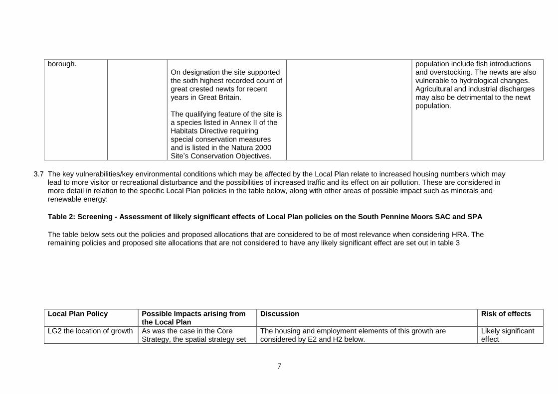
7
borough.
On designation the site supported the sixth highest recorded count of great crested newts for recent years in Great Britain. The qualifying feature of the site is a species listed in Annex II of the Habitats Directive requiring special conservation measures and is listed in the Natura 2000 Site’s Conservation Objectives.
population include fish introductions and overstocking. The newts are also vulnerable to hydrological changes. Agricultural and industrial discharges may also be detrimental to the newt population.
3.7 The key vulnerabilities/key environmental conditions which may be affected by the Local Plan relate to increased housing numbers which may lead to more visitor or recreational disturbance and the possibilities of increased traffic and its effect on air pollution. These are considered in more detail in relation to the specific Local Plan policies in the table below, along with other areas of possible impact such as minerals and renewable energy:
Table 2: Screening - Assessment of likely significant effects of Local Plan policies on the South Pennine Moors SAC and SPA
The table below sets out the policies and proposed allocations that are considered to be of most relevance when considering HRA. The remaining policies and proposed site allocations that are not considered to have any likely significant effect are set out in table 3
Local Plan Policy Possible Impacts arising from the Local Plan
Discussion Risk of effects
LG2 the location of growth
As was the case in the Core Strategy, the spatial strategy set
The housing and employment elements of this growth are considered by E2 and H2 below.
Likely significant effect
8
out in this policy is to focus growth on urban Barnsley and the Principal Towns. Urban Barnsley is in the centre of the Borough and relatively remote from the sensitive areas associated with the sites. The majority of the Principal towns are located in the east of the borough. Together these areas are intended to see the most growth in Barnsley. The nearest location for growth to the sites is Penistone. The change in the Local Plan is that there will be more growth here than was previously intended. There are two proposed housing allocations that lie within the 5km buffer and some which lie just outside the buffer.
One of the main issues for the Local Plan is any potential loss of feeding areas for birds outside the site boundary in the west of the borough. Whilst there is not a clear radius where effects may occur, the areas of land which are important for the birds are likely to be the upland grasslands close to the
In general terms it is considered that this spatial strategy is unlikely to affect Natura 2000 sites. However there does remain a small possibility of low-level, indirect impacts due to increased recreational pressures from new residents. In line with the precautionary principle there are a number of policies in the Local Plan which would help to avoid or protect against and adverse effect on sites. These include: BIO1 Biodiversity and Geodiversity states that development will be expected to conserve and enhance the biodiversity and geological features of the borough by:
Protecting and improving habitats, species, sites of ecological value and sites of geological value with particular regard to designated wildlife and geological sites of international, national and local significance
Development which may harm a biodiversity or geological feature will not be permitted unless effective mitigation and/or compensatory measures can be ensured. The South Pennine Moors SCA and SPA are specifically mentioned in the supporting text for the policy LC1 Landscape Character states that development will be expected to retain and enhance the character and distinctiveness of the individual Landscape Character Area in which it is located (as set out in the Landscape Character Assessment of Barnsley Borough 2002 and any future updates) The following policies would also serve to offset any possible effects on the sites: GI1 Green Infrastructure states that we will create, maintain and enhance an integrated network of connected and multifunctional

9
SPA/SAC.
open spaces that amongst other things
Enhances biodiversity and landscape character At a strategic level we have identified a number of GI corridors which include:
River Don Valley Corridor The supporting text for the policy recognises that this corridor crosses several local authority boundaries and flows through a varied landscape extending from the South Pennine moors. We have a GI Strategy for the borough which considers these issues further. GB1 Green Belt seeks to protect the general extent of the green belt and requires that development within them is in accordance with PPS2. Approximately 75% of Barnsley is proposed to remain in Green Belt and this policy offers the majority of the west of the borough protection from inappropriate development. GS1 Greenspace seeks to protect and improve all areas of greenspace to meet the standards in our greenspace strategy. This policy also expects new development to provide and maintain appropriate greenspace in accordance with I1 Infrastructure and Planning Obligations. Details on this provision will be set out in a SPD Our Green Space Strategy Part 1 was adopted by the Council in 2006. It identifies types of greenspace, what they are used for and sets out standards for greenspaces which describes how much should be available to people within set distances of their homes. In addition there are measures and actions being undertaken with regard to habitats through the Barnsley Biodiversity Action Plan 2008 – 2012 (still in force but under review). Relevant sections of this are attached at Appendix 2.

10
Policy H2 the distribution of new homes
Related to LG2 this policy seeks to distribute new homes across the borough and indicates 1026 new homes for Penistone, 373 of which already have planning permission.
This is a relatively low level of housing growth compared with the other locations across the borough where housing is to be focussed. Of all the other areas of growth only Royston has a lower figure for housing numbers.
The main impact of the new houses will be increased recreational pressure on adjacent open areas. Given that the housing growth is relatively small it is anticipated that the any impacts will also be of a small scale. As detailed above we will also require new developments to provide on-site greenspace which should be appropriate to the needs of the area, would also meet the recreational needs of new residents and offset any pressure on sensitive areas.
Our Green Space Strategy sets out standards for green space in relation to:
quantity – making sure each town and village has enough green space of each type;
accessibility – how far people should expect to go to get to green spaces; and
quality – the quality of the space people should expect to find.
With regard to the natural and semi-natural areas we have set a standard of a 2ha site within 800m of the settlement. We will aim to meet these standards and in doing so should provide people with access to open areas. Ensuring that a hierarchy of natural areas are provided in line with the Green Space strategy standards, there is less pressure to access more sensitive sites, such as the SAC and SPA. In terms of recreational routes from Penistone to the Peak Park and sensitive sites, the main non-motorised route is the Trans
Likely significant effect

11
Pennine Trail (TPT), a long distance muti-user public path. Barnsley and Sheffield councils are currently creating the Little Don Trail which will be a further multi-user trail running from Stocksbridge to Langsett (and then connecting to the TPT near Hazelhead), largely on a disused railway line. There are not any other major routes and as such intrusion should be minimised. In addition Derbyshire County Council have produced maps of Public Rights Of Way (PRoW) routes which show a limited number of routes into the Peak Park from Barnsley that intrude onto the SAC and SPA sites. Furthermore their remoteness means they are unlikely to appeal to the typical urban visitor to the moors. It is recognised for example that people like to walk their dog within 15 minutes of home. As such people in Penistone are more likely to use locally accessible greenspaces such as Penistone Recreation Ground and the Meadows along with other smaller greenspaces in Penistone rather than putting significant additional pressure on sensitive sites.
E2 the distribution of new employment sites
Again related to LG2 this policy seeks to distribute employment land across the borough and indicates only 3.27ha of employment land in Penistone
With the exception of Royston, this is the lowest level of employment growth compared with other locations across the borough and this low level of employment provision is considered to be unlikely to have any effects. Particularly since the introduction of new employment uses are not likely to lead to intensified recreational use of sensitive sites. However, one site is close to the 5km buffer and could contribute to increased indirect impacts on the Natura 2000 sites.
Likely significant effect
H8 Affordable Housing Policy
Where a need can be proven this policy allows affordable housing as an exception to other policies in the plan in rural villages, some of which are in the west of the
The policy requires sites for affordable housing in the rural settlements to be clearly related to need and in sustainable locations, within the village boundaries where possible. As such they are likely to be small scale.
No likely significant effect

12
borough where there is a particular need and lack of provision
The number of homes likely to come forward under this policy are limited and will be considered via the development management process rather than through allocations.
GB6 Safeguarded Land This policy sets out that the permanent development of safeguarded land will only be permitted following adoption of a replacement Local Plan which proposes development. Some flexibility may be allowed where there is a shortage of housing land supply and it can be proven that no alternative site is available to meet the need and the site is considered to be sustainable. Otherwise development will not take place on safeguarded sites until after 2033.
There are five proposed safeguarded sites. Implications of these are considered further in the table below.
SAF 16 West of Castle Lane, Penistone
SAF17 East of Castle Lane, Penistone
SAF 18 North and South of Roughbirchworth Lane, Oxspring
SAF 21 South of New Smithy Drive, Thurlstone 4.40 ha
SAF31 Land off Mortimer Road, Cubley
SAF37 Land Springvale, Penistone
SAF 38 Land off Moors Avenue, Penistone
No likely significant effect
RE1 Low Carbon and Renewable energy
This policy allows development that produces renewable energy provided that there is no significantly harmful effect on:
The character of the landscape and appearance of the area
Living conditions
Biodiversity, geodiversity and water quality
Heritage assets, their
The policy is not locationally specific and does not identify any areas of the Borough as being suitable for renewable energy uses. There are no proposed site allocations.
Proposals for renewable energy will be considered against this criteria based policy through the development management system. There will be a supplementary planning document produced in due course.
The supporting text refers to the importance of balancing the effects of any proposals on Natura 2000 sites specifically.
No likely significant effect
13
settings and cultural features and areas
Highway safety; and
Infrastructure including radar
It also requires proposals to be accompanied by information regarding their efficiency and that shows how the local environment will be protected, and that the site will be restored when production ends.
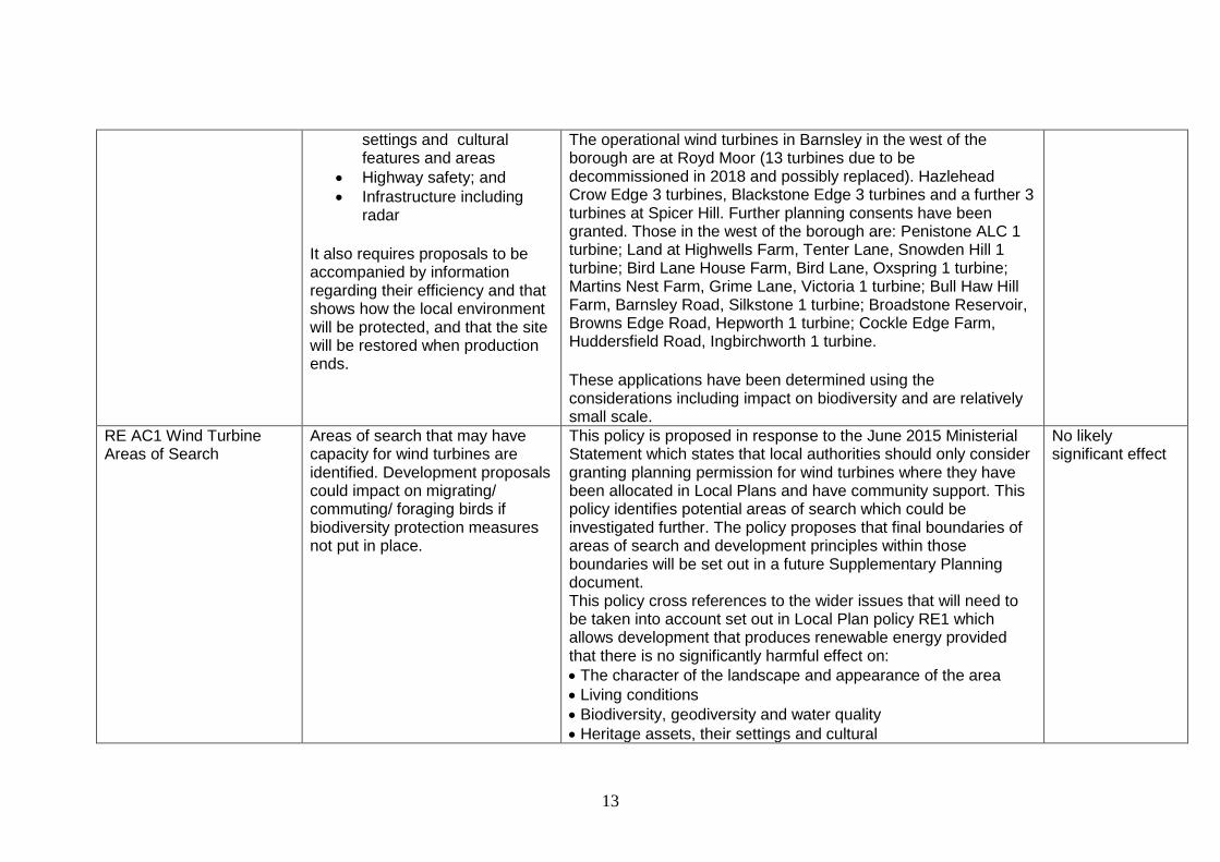
The operational wind turbines in Barnsley in the west of the borough are at Royd Moor (13 turbines due to be decommissioned in 2018 and possibly replaced). Hazlehead Crow Edge 3 turbines, Blackstone Edge 3 turbines and a further 3 turbines at Spicer Hill. Further planning consents have been granted. Those in the west of the borough are: Penistone ALC 1 turbine; Land at Highwells Farm, Tenter Lane, Snowden Hill 1 turbine; Bird Lane House Farm, Bird Lane, Oxspring 1 turbine; Martins Nest Farm, Grime Lane, Victoria 1 turbine; Bull Haw Hill Farm, Barnsley Road, Silkstone 1 turbine; Broadstone Reservoir, Browns Edge Road, Hepworth 1 turbine; Cockle Edge Farm, Huddersfield Road, Ingbirchworth 1 turbine.
These applications have been determined using the considerations including impact on biodiversity and are relatively small scale.
RE AC1 Wind Turbine Areas of Search
Areas of search that may have capacity for wind turbines are identified. Development proposals could impact on migrating/ commuting/ foraging birds if biodiversity protection measures not put in place.
This policy is proposed in response to the June 2015 Ministerial Statement which states that local authorities should only consider granting planning permission for wind turbines where they have been allocated in Local Plans and have community support. This policy identifies potential areas of search which could be investigated further. The policy proposes that final boundaries of areas of search and development principles within those boundaries will be set out in a future Supplementary Planning document. This policy cross references to the wider issues that will need to be taken into account set out in Local Plan policy RE1 which allows development that produces renewable energy provided that there is no significantly harmful effect on:
The character of the landscape and appearance of the area
Living conditions
Biodiversity, geodiversity and water quality
Heritage assets, their settings and cultural
No likely significant effect

14
features and areas
Highway safety; and
Infrastructure including radar It also requires proposals to be accompanied by information regarding their efficiency and that shows how the local environment will be protected, and that the site will be restored when production ends. The supporting text of RE1 refers to the importance of balancing the effects of any proposals on Natura 2000 sites specifically. The Areas of Search proposed are taken from the South Pennines Wind Energy Landscape Study, and are those areas of the borough considered to have the greatest capacity to accommodate a limited amount of new wind turbine development, although it indicates that the areas are sensitive to turbines of different heights to varying degrees. The text also makes clear that cumulative impacts will always need to be taken into account. Further supporting text has been added regarding the need to protect valued landscapes in the west of the borough, the neighbouring Peak District National Park and Southern Pennine Fringe.
Policy CC AC1 Water Resource Management
Policy supports proposals which conserve and enhance the borough’s water courses. If any impacts arise from this policy on the SAC and SPA, effects should only be positive
This policy has been proposed following the implementation of the Water Framework Directive. This is a European Directive which together with emerging river basin management plans, looks at the integrated management of water resources, taking account of abstraction, water quality and flooding. The proposed additional policy seeks to support proposals which:
do not result in the deterioration of water courses and conserve and enhance natural geomorphology; water
No likely significant effect

15
quality and ecological value of the water environment, None
10 including watercourse corridors
contribute towards achieving ‘good’ status under the Water Framework Directive in surface and ground water bodies
manage water demand and improve water efficiency through appropriate water conservation techniques including rain water harvesting and grey-water recycling
dispose of surface water appropriately and improve water quality through the incorporation of SuDS No potential adverse effects would therefore be expected to arise from this policy. Any effects arising from conserving and enhancing water resources which provide valuable wildlife habitats and biodiversity opportunities should only have a positive impact on the SAC and SPA.
E7 promoting tourism and encouraging cultural provision
This policy states that we will promote tourism and encourage the growth and development of cultural provision by amongst other things:
Promoting the existing cultural provision and tourism offer and
Encouraging the growth of the tourism business sector
The supporting text for the policy states that development ‘must also be sensitive to and integrate well with its countryside and landscape setting in accordance with E8’
No likely significant effect
E8 Rural economy This policy states as follows:
We will encourage a viable rural economy by allowing
This policy makes it clear that the rural economy must not have a harmful effect on the countryside, biodiversity, green belt, landscape or local character of the area.
As such it considered that proposals for rural economy uses
No likely significant effect

16
development in rural areas if it:
Supports the sustainable diversification and development of the rural economy; or
Results in the growth of existing businesses; or
Is related to tourism or recreation; or
Improves the range and quality of local services in existing settlements
Development in rural areas must:
Be of a scale and size proportionate to the size and role of the settlement
Be directly related the needs of the settlement
Not have a harmful impact on the countryside, biodiversity, green belt, landscape or local character of the area
Consider the re-use of existing rural buildings in the first instance
Protect the best quality agricultural land
would not be allowed to have any significant impact on the sites.
Transport Transport proposals in the Local T1 Accessibility Priorities seeks to improve sustainable No likely

17
Plan for the west of the Borough are based on improvements to the existing links. The A628 is identified as a key road route to the Accessibility Improvement Zone. This zone is in the east of the borough and relates to the main areas of growth, it will be the focus of transport investment.
transport and circulation in the AIZ, particularly between Principal Towns.
It also seeks to facilitate sustainable transport links to and from existing and proposed employment, interchange, community and leisure and tourism facilities in the borough, including the Peak District National Park
Policy T2 Safeguarding of former railway lines. The reinstatement of former strategic railway lines would provide for continuing growth associated with a robust sustainable transport framework beyond the plan period. The reinstatement of these lines is not required to serve the Local Plan proposals and time scales. The Local Plan consultation draft Policies Map shows the Woodhead route safeguarded as far as the Local Plan Policies Map boundary. However, reinstatement of the route is not a BMBC proposal. Any reinstatement or alternative (‘HS3’ as currently summarily referred to) would be promoted outside of the Local Plan. The Local Plan policy is ensuring that no development would compromise the reinstatement of the rail route rather than
promoting the reinstatement of the rail line.
T5 reducing the impact of road travel furthermore sets out how we will reduce the impact of road travel by:
Developing and implementing robust evidence based air quality action plans to improve air quality
Working with our sub regional partners, fleet and freight operators to improve the efficiency of vehicles and goods delivery and to reduce exhaust emissions
Implementing measures to ensure the current road system is used efficiently
significant effect

18
Journeys westward from Barnsley are most likely to be as a result of trips to Derbyshire (over the A628 Woodhead Pass) and beyond. The 2011 Journey to Work Census data indicates 472 trips (0.5% of all such trips) from Barnsley to Derbyshire and 437 trips ( 0.7% of all such trips) from Derbyshire to Barnsley and beyond. Therefore the volume remains very modest, and is likely to have minimal impact.
The flows of commuters between Local Authorities data provided by ONS (sourced from Annual Population Survey) confirms that there is a negligible flow of westward commuting (inward or outward).
Given this situation and the policies in place in the Transportation chapter of the Local Plan there are not considered to be significant effects from these policies on the sites.
MIN1 Minerals This policy sets out the Council’s strategic approach to minerals. It states that amongst other things:
Existing sites with planning permission for the extraction of are shown on the policies map which will accompanies the Local Plan
Areas of Search are identified
An Area of safeguarding is identified. The policy also states that all minerals
In Barnsley we have no mineral resources suitable for use as aggregate minerals.
The Minerals allocations which may have a possible impact are the Areas of Search and an area of minerals safeguarding identified in the Local Plan.
The closest area of safeguarding is at Hillside Quarry, Cross Lane, Hillside, Thurlstone and is subject to a planning application therefore the implications of mineral extraction are being considered through the planning application process. This will consider any possible impacts on Natura 2000sites.
The implications of these allocations are considered in the table below.
Likely significant effect

19
proposals should:
Be of limited duration
Have no unacceptable adverse environmental or amenity impacts
Be subject to high quality appropriate reclamation and afteruse within a reasonable timescale: and
Result in a net increase in biodiversity and/or geodiversity interests
3.8 Other Sites and Policies with no Likely Significant Effects The following table 3 contains the Local Plan policies and proposed site allocations that are not specifically referred to in table 2 above. These are not considered to have any likely significant effect when considering the Habitats Regulations Assessment, but are listed below for completeness.
Policy SD1 Presumption in Favour of Sustainable Development – No Likely Significant Effect – this policy refers to the NPPF protection [for biodiversity].
Policy GD1 General Development– No Likely Significant Effect –this policy states development will only be permitted if impacts on the environment and natural resources are minimised and mitigated.
Policy GD2 Temporary Buildings and Uses– No Likely Significant Effect – By the type of their likely small size and temporary status, these buildings and uses are unlikely to impact.
Location of Growth
Policy LG1 City Regions– No Likely Significant Effect – This policy is not site-specific and any possible impacts are addressed by a combination of site policies and other generic policies such as BIO1.
Economy

20
Policy E1 Providing Strategic Employment Locations– No Likely Significant Effect – This policy is not site-specific and any possible impacts are addressed by a combination of site policies and other generic policies such as BIO1.
Policy E3 Employment Site Policies– No Likely Significant Effect – This policy is not site-specific and any possible impacts are addressed by a combination of site policies and other generic policies such as BIO1.
Urban Barnsley
Site UB1 Birthwaite Business Park– No Likely Significant Effect – site more than 10km from South Pennine Moors SAC and SPA
Site UB3 Claycliffe Business Park– No Likely Significant Effect – site more than 10km from South Pennine Moors SAC and SPA
Site UB5 Zenith Business Park– No Likely Significant Effect – site more than 10km from South Pennine Moors SAC and SPA
Site UB7 Capitol Park Extension– No Likely Significant Effect – site more than 10km from South Pennine Moors SAC and SPA
Site UB8 Capitol Park – No Likely Significant Effect – site more than 10km from South Pennine Moors SAC and SPA
Site UB12 Bromcliffe Business Park– No Likely Significant Effect – site more than 10km from South Pennine Moors SAC and SPA
Site UB13 Oaks Business Park– No Likely Significant Effect – site more than 10km from South Pennine Moors SAC and SPA
Site UB16 Bleachcroft Way Industrial Estate– No Likely Significant Effect – site more than 10km from South Pennine Moors SAC and SPA
Cudworth
Site C2 Land off Ferrymoor Way– No Likely Significant Effect – site more than 10km from South Pennine Moors SAC and SPA
Site C3 Land West of Springvale Road– No Likely Significant Effect – site more than 10km from South Pennine Moors SAC and SPA
Dearne
Site D1 Land South of Dearne Valley Parkway– No Likely Significant Effect – site more than 10km from South Pennine Moors SAC and SPA
Site D2 Fields End Business Park– No Likely Significant Effect – site more than 10km from South Pennine Moors SAC and SPA
Site D3 Thurnscoe Business Park– No Likely Significant Effect – site more than 10km from South Pennine Moors SAC and SPA
Hoyland
Site Hoy1 Land West of Sheffield Road– No Likely Significant Effect – site more than 10km from South Pennine Moors SAC and SPA
Site HOY2 Rockingham– No Likely Significant Effect – site more than 10km from South Pennine Moors SAC and SPA
Site HOY3 Shortwood Extension– No Likely Significant Effect – site more than 10km from South Pennine Moors SAC and SPA
Site HOY4 Shortwood Business Park– No Likely Significant Effect – site more than 10km from South Pennine Moors SAC and SPA
Site HOY5 Land South of Dearne Valley Parkway– No Likely Significant Effect – site more than 10km from South Pennine Moors SAC and SPA
Site HOY7 Ashroyd– No Likely Significant Effect – site more than 10km from South Pennine Moors SAC and SPA
Wombwell
Site W2 Everill Gate Lane– No Likely Significant Effect – site more than 10km from South Pennine Moors SAC and SPA
Land outside Urban Barnsley and Principal Towns
Site N1 Wentworth Industrial Park, Tankersley– No Likely Significant Effect – site more than 9km from South Pennine Moors SAC and SPA
Site N2 Park Springs, Houghton– No Likely Significant Effect – site more than 10km from South Pennine Moors SAC and SPA
Site N5 Land South of Park Springs– No Likely Significant Effect – site more than 10km from South Pennine Moors SAC and SPA

21
Policy E4 Land Reserved for employment– No Likely Significant Effect – No Likely Significant Effect – site more than 10km from South Pennine Moors SAC and SPA
Site RSV1 Land reserved for employment, south of Dearne Valley Parkway– No Likely Significant Effect – site more than 10km from South Pennine Moors SAC and SPA
Policy E5 Uses on employment land– No Likely Significant Effect – This policy is not site-specific and any possible impacts are addressed by a combination of site policies and other generic policies such as BIO1.
Policy E6 Protecting Existing Employment Land– No Likely Significant Effect – This policy is not site-specific and any possible impacts are addressed by a combination of site policies and other generic policies such as BIO1.
Policy E7 Promoting Tourism and encouraging Cultural Provision– No Likely Significant Effect – This policy is not site-specific and any possible impacts are addressed by a combination of site policies and other generic policies such as BIO1. However the policy does state that new facilities will be focussed within existing centres where possible.
Policy E8 Rural Economy– No Likely Significant Effect – This policy is not site-specific but does apply to more land close to the South Pennine Moors SAC and SPA than most other generic policies. Any possible impacts are addressed by a combination of site policies and other generic policies such as BIO1.
Policy E9 Loss of Local Services and Community Facilities in Villages– No Likely Significant Effect – This policy is not site-specific and any possible impacts are addressed by a combination of site policies and other generic policies such as BIO1.
Housing
Policy H1 The number of new homes to be built– No Likely Significant Effect – This policy does not, of itself, pose a significant risk to the South Pennine Moors SAC and SPA. It is not site-specific and any possible impacts are addressed by a combination of site policies and other generic policies such as BIO1.
Policy H3 Housing Site Policies– No Likely Significant Effect – This policy does not, of itself, pose a significant risk to the South Pennine Moors SAC and SPA. It is not site-specific and any possible impacts are addressed by a combination of site policies and other generic policies such as BIO1.
Urban Barnsley
Site AC1 Former Woolley Colliery– No Likely Significant Effect – site more than 10km from South Pennine Moors SAC and SPA
Site AC2 Land south of Darton Lane, Staincross– No Likely Significant Effect – site more than 10km from South Pennine Moors SAC and SPA
Site AC3 Former William Freeman site, Wakefield Road– No Likely Significant Effect – site more than 10km from South Pennine Moors SAC and SPA
Site AC6 Longcar PDC– No Likely Significant Effect – site more than 10km from South Pennine Moors SAC and SPA
Site AC10 Land south of West Street, Worsbrough– No Likely Significant Effect – site more than 10km from South Pennine Moors SAC and SPA
Site H5 Land south of Coniston Avenue, Darton– No Likely Significant Effect – site more than 10km from South Pennine Moors SAC and SPA
Site H13 Land East of Burton Road, Monk Bretton– No Likely Significant Effect – site more than 10km from South Pennine Moors SAC and SPA
Site H14 West of Wakefield Road, Mapplewell– No Likely Significant Effect – site more than 10km from South Pennine Moors SAC and SPA
Site H18 Land East of Smithy Wood Lane, Gilroyd– No Likely Significant Effect – site more than 10km from South Pennine Moors SAC and SPA

22
Site H19 Land north of Keresforth Road, Dodworth– No Likely Significant Effect – site more than 10km from South Pennine Moors SAC and SPA
Site H20 Land south of Bloomhouse Lane, Darton– No Likely Significant Effect – site more than 10km from South Pennine Moors SAC and SPA
Site H24 Site north of Carlton Road– No Likely Significant Effect – site more than 10km from South Pennine Moors SAC and SPA
Site H28 Former Priory School/ Land off Rotherham Road, Cundy Cross– No Likely Significant Effect – site more than 10km from South Pennine Moors SAC and SPA
Site H29 Garden House Farm, Garden House Close, Monk Bretton– No Likely Significant Effect – site more than 10km from South Pennine Moors SAC and SPA
Site H31 Land west of Smithy Wood Land, Gilroyd– No Likely Significant Effect – site more than 10km from South Pennine Moors SAC and SPA
Site H33 Site to the east of St Helens Avenue– No Likely Significant Effect – site more than 10km from South Pennine Moors SAC and SPA
Site H42 Land west of Wakefield Road– No Likely Significant Effect – site more than 10km from South Pennine Moors SAC and SPA
Site H44 land to the north of West Green Way, West Green– No Likely Significant Effect – site more than 10km from South Pennine Moors SAC and SPA
Site H48 Site of former Kingstone High School– No Likely Significant Effect – site more than 10km from South Pennine Moors SAC and SPA
Site H53 Land north of Wilthorpe Road, Wilthorpe– No Likely Significant Effect – site more than 10km from South Pennine Moors SAC and SPA
Site H54 Land off High Street, Dodworth– No Likely Significant Effect – site more than 10km from South Pennine Moors SAC and SPA
Site H57 Monk Bretton Reservoir and land to the east of Cross Street– No Likely Significant Effect – site more than 10km from South Pennine Moors SAC and SPA
Site H59 Land at St Michaels Avenue– No Likely Significant Effect – site more than 10km from South Pennine Moors SAC and SPA
Site H62 Land off Highstone Lane, Worsbrough Common– No Likely Significant Effect – site more than 10km from South Pennine Moors SAC and SPA
Site H72 Land north of Kingwell Road– No Likely Significant Effect – site more than 10km from South Pennine Moors SAC and SPA
Site H73 Land between Mount Vernon Road and Upper Sheffield Road– No Likely Significant Effect – site more than 10km from South Pennine Moors SAC and SPA
Site H83 land to the east of Woolley Colliery Road– No Likely Significant Effect – site more than 10km from South Pennine Moors SAC and SPA
Site UB6 land adjacent Zenith Business Park– No Likely Significant Effect – site more than 10km from South Pennine Moors SAC and SPA
Site 290 Land south west of Priory Road– No Likely Significant Effect – site more than 10km from South Pennine Moors SAC and SPA
Site 503 Land off Leighton Close – No Likely Significant Effect – site more than 10km from South Pennine Moors SAC and SPA
Cudworth
Site AC22 land off High Street Shafton– No Likely Significant Effect – site more than 10km from South Pennine Moors SAC and SPA
Site AC23 Land off Pontefract Road– No Likely Significant Effect – site more than 10km from South Pennine Moors SAC and SPA
Site H10 Land west of Brierley Road, Grimethorpe– No Likely Significant Effect – site more than 10km from South Pennine Moors SAC and SPA
Site H22 Land north of Blacker Lane, Shafton– No Likely Significant Effect – site more than 10km from South Pennine Moors SAC and SPA
Site H32 land adjacent Carrs Lane/ Summerdale Road, Cudworth– No Likely Significant Effect – site more than 10km from South Pennine Moors

23
SAC and SPA
Site H39 Land at Weetshaw Lane, Cudworth– No Likely Significant Effect – site more than 10km from South Pennine Moors SAC and SPA
Site H74 Land north of Sidcop Road, Cudworth– No Likely Significant Effect – site more than 10km from South Pennine Moors SAC and SPA
Site H75 Land off Cudworth Bypass– No Likely Significant Effect – site more than 10km from South Pennine Moors SAC and SPA
Site H76 Land west of Three Nooks Lane, Cudworth– No Likely Significant Effect – site more than 10km from South Pennine Moors SAC and SPA
Site H87 Land north of Oak Tree Avenue– No Likely Significant Effect – site more than 10km from South Pennine Moors SAC and SPA
Site 897 Former Willowgarth School– No Likely Significant Effect – site more than 10km from South Pennine Moors SAC and SPA
Goldthorpe (Dearne Towns)
Site AC26 Land south of Lowfield Road, Bolton on Dearne– No Likely Significant Effect – site more than 10km from South Pennine Moors SAC and SPA
Site H1 Former Reema Estate and adjoining land, off School Street, Thurnscoe– No Likely Significant Effect – site more than 10km from South Pennine Moors SAC and SPA
Site H12 Bolton House Farm, Goldthorpe– No Likely Significant Effect – site more than 10km from South Pennine Moors SAC and SPA
Site H17 Land south of Barnburgh Lane– No Likely Significant Effect – site more than 10km from South Pennine Moors SAC and SPA
Site H30 Land north of East Street,Goldthorpe– No Likely Significant Effect – site more than 10km from South Pennine Moors SAC and SPA
Site H50 Land north of Dearne ALC, Goldthorpe– No Likely Significant Effect – site more than 10km from South Pennine Moors SAC and SPA
Site H52 South Of Beever Street– No Likely Significant Effect – site more than 10km from South Pennine Moors SAC and SPA
Site H55 at Brunswick Street– No Likely Significant Effect – site more than 10km from South Pennine Moors SAC and SPA
Site H67 to the East of Broadwater Estate– No Likely Significant Effect – site more than 10km from South Pennine Moors SAC and SPA
Site H84 Land west of Thurnscoe Bridge Lane and south of Derry Grove, Thurnscoe– No Likely Significant Effect – site more than 10km from South Pennine Moors SAC and SPA
Site 311 South of King Street– No Likely Significant Effect – site more than 10km from South Pennine Moors SAC and SPA
Site 372 Land off Gooseacre Avenue, Thurnscoe– No Likely Significant Effect – site more than 10km from South Pennine Moors SAC and SPA
Site 496 Former Highgate Social Centre– No Likely Significant Effect – site more than 10km from South Pennine Moors SAC and SPA
Hoyland
Site AC29 Land off Shortwood– No Likely Significant Effect – site more than 10km from South Pennine Moors SAC and SPA Roundabout, Hoyland
Site AC30 Land at Tankersley Lane– No Likely Significant Effect – site more than 10km from South Pennine Moors SAC and SPA
Site AC31 Land at Broad Carr Road, Hoyland– No Likely Significant Effect – site more than 10km from South Pennine Moors SAC and SPA
Site H2 Land west of Fitzwilliam Street, Elsecar– No Likely Significant Effect – site more than 10km from South Pennine Moors SAC and SPA
Site H4 land south of Hay Green Lane– No Likely Significant Effect – site more than 10km from South Pennine Moors SAC and SPA

24
Site H6 Land at Greenside Lane, Hoyland– No Likely Significant Effect – site more than 10km from South Pennine Moors SAC and SPA
Site H7 Land off Clough Fields Road, Hoyland Common– No Likely Significant Effect – site more than 10km from South Pennine Moors SAC and SPA
Site H8 Land off Meadowfield Drive– No Likely Significant Effect – site more than 10km from South Pennine Moors SAC and SPA
Site H9 Land off Welland Crescent, Hoyland– No Likely Significant Effect – site more than 10km from South Pennine Moors SAC and SPA
Site H16 North of Hoyland Road– No Likely Significant Effect – site more than 10km from South Pennine Moors SAC and SPA
Site H45 Land north of Stead Lane, Hoyland– No Likely Significant Effect – site more than 10km from South Pennine Moors SAC and SPA
Site H77 Land West of Upper Hoyland Road– No Likely Significant Effect – site more than 10km from South Pennine Moors SAC and SPA
Site 877 Land at Sheffield Road, Birdwell– No Likely Significant Effect – site more than 10km from South Pennine Moors SAC and SPA
Penistone
Site AC34 Land north of Barnsley Road, Penistone– No Likely Significant Effect – see table 4 below.
Site H25 Land at Talbot Road, Penistone– No Likely Significant Effect – see table 4 below.
Site H34 Land east of Saunderson Avenue, Penistone– No Likely Significant Effect – see table 4 below.
Site H47 Land south east of Schole Hill Lane, Penistone– No Likely Significant Effect – see table 4 below.
Site H81 Land south of Well House Lane, Penistone– No Likely Significant Effect – see table 4 below.
Site H82 Land south of Halifax Road, Penistone– No Likely Significant Effect – see table 4 below.
Royston
Site H11 Land off Lee Lane, Royston– No Likely Significant Effect – site more than 10km from South Pennine Moors SAC and SPA
Site H43 Land at end of Melton Way, Royston– No Likely Significant Effect – site more than 10km from South Pennine Moors SAC and SPA
Wombwell
Site AC39 Land at Pitt Street Wombwell– No Likely Significant Effect – site more than 10km from South Pennine Moors SAC and SPA
Site H3 Land south of Doncaster Road, Darfield– No Likely Significant Effect – site more than 10km from South Pennine Moors SAC and SPA
Site H40 Former Foulstone School Playing fields– No Likely Significant Effect – site more than 10km from South Pennine Moors SAC and SPA
Site H42 Former Foulstone School– No Likely Significant Effect – site more than 10km from South Pennine Moors SAC and SPA
Site H56 Land rear of Kings Oak Primary, Wombwell– No Likely Significant Effect – site more than 10km from South Pennine Moors SAC and SPA
Site H63 Land off Newsome Avenue, Wombwell– No Likely Significant Effect – site more than 10km from South Pennine Moors SAC and SPA
Site H64 Former Kings Road School Site, Wombwell– No Likely Significant Effect – site more than 10km from South Pennine Moors SAC and SPA
Site H70 Land east of Lundhill Road, Wombwell– No Likely Significant Effect – site more than 10km from South Pennine Moors SAC and SPA
Site 232 Land at Hill Street/ Snape Hill Road, Darfield– No Likely Significant Effect – site more than 10km from South Pennine Moors SAC and SPA
Site 308 Land at New Street Wombwell– No Likely Significant Effect – site more than 10km from South Pennine Moors SAC and SPA
Site 377 Land east of Wortley Avenue, Wombwell– No Likely Significant Effect – site more than 10km from South Pennine Moors SAC and SPA
Land outside Urban Barnsley and Principal Towns
Site AC44 Former Paper Mill, Oughtibridge– No Likely Significant Effect – see table 4 below.

25
Policy H4 Uses on allocated housing sites– No Likely Significant Effect – by their very type these developments can only be small and ancilliary to housing elements.
Policy H5 Residential Development on small non-allocated sites– No Likely Significant Effect – by their nature these developments can only be small and must comply with other generic policies such as BIO1.
Policy H6 Residential development on large non allocated sites– No Likely Significant Effect – The policy states that development will be allowed where it is within existing built up areas and hence there is no likely significant effect.
Policy H7 Housing Mix and Efficient Use of Land– No Likely Significant Effect – This policy is about a broad mix of house type and hence not an issue that will affect the South Pennine Moors SAC and SPA.
Policy H9 Housing Regeneration Areas– No Likely Significant Effect – all these areas are more than 10km from South Pennine Moors SAC and SPA
Policy H10 Protection of Existing Larger Dwellings– No Likely Significant Effect – This policy relates to development within the curtilage of existing larger dwellings and so is covered by other generic policies such as BIO1.
Sites for Gypsies and Travellers
Policy GT1 Sites for Travellers and Travelling Showpeople– No Likely Significant Effect – Although the impcts that could arise from such developments are covered by other generic policies such as BIO1, the policy does say that they will primarily be located within urban areas.
Site Policy GT2 Sites for Travellers: TRAV013A Land at Carlton Industrial Estate– No Likely Significant Effect – site more than 10km from South Pennine Moors SAC and SPA
Site Policy GT2 Sites for Travellers: AC46 Burntwood Cottages Extension– No Likely Significant Effect – site more than 10km from South Pennine Moors SAC and SPA
Mixed Use Sites
Policy Mixed Use Sites 1– No Likely Significant Effect – all sites are more than 10km from South Pennine Moors SAC and SPA
Urban Barnsley
Site MU1 South of Barugh Green Road– No Likely Significant Effect – site more than 10km from South Pennine Moors SAC and SPA
Site AC11 Land between Fish Dam Lane and Carlton Road– No Likely Significant Effect – site more than 10km from South Pennine Moors SAC and SPA
Site AC12 Land off Shaw Lane– No Likely Significant Effect – site more than 10km from South Pennine Moors SAC and SPA
Site AC16 Land off Broadway– No Likely Significant Effect – site more than 10km from South Pennine Moors SAC and SPA
Wombwell
Site AC40 Former Wombwell High School, Wombwell– No Likely Significant Effect – site more than 10km from South Pennine Moors SAC and SPA
Education
Policy ED1 Primary School site policies– No Likely Significant Effect – all sites are more than 10km from South Pennine Moors SAC and SPA
Urban Barnsley
Site AC11 Land between Fish Dam Lane and Carlton Road– No Likely Significant Effect – site more than 10km from South Pennine Moors SAC and SPA

26
Site MU1 Land south of Barugh Green Road– No Likely Significant Effect – site more than 10km from South Pennine Moors SAC and SPA
Royston
Site 186 Land at Lee Lane, Royston– No Likely Significant Effect – site more than 10km from South Pennine Moors SAC and SPA
Wombwell
Site AC40 Former Wombwell High School, Wombwell– No Likely Significant Effect – site more than 10km from South Pennine Moors SAC and SPA
Transport
Policy T3 New Development and Sustainable Travel– No Likely Significant Effect – this policy ensures new developments will be more sustainable and is likely to actually benefit biodiversity generally. Other generic policies such as BIO1 will protect the South Pennine Moors SAC and SPA regarding proposed nearby developments.
Policy T4 New Development and Highway Improvement– No Likely Significant Effect – This policy is about access off the highway.
Policy T5 Reducing the Impact of Road Travel– No Likely Significant Effect –This policy is regarding reducing air pollution and congestion which mainly affects the existing urban areas, but effects are discussed regarding policies T1 and T5 in table 2 above.
Local Character
Policy D1 Design– No Likely Significant Effect – This generic policy requires development to respect existing borough features such as habitats etc.
Historic Environment
Policy HE1 The Historic Environment– No Likely Significant Effect – This policy is about conserving the built heritage environment.
Policy HE2 Heritage Statements and General application procedures– No Likely Significant Effect – This policy is about conserving the built heritage environment.historic environment.
Policy HE3 Developments affecting Historic Buidlings– No Likely Significant Effect – This policy is about conserving the historic environment.
Policy HE4 Developments affecting Historic Areas or Landscapes– No Likely Significant Effect – this policy is about preserving existing value.
Policy HE5 the Demolition of Historic Buildings– No Likely Significant Effect – This policy is about conserving the built heritage environment.
Policy HE6 Archaeology– No Likely Significant Effect – This policy is about conserving the built heritage environment.
Town Centres and Retail
Policy TC1 Town Centres– No Likely Significant Effect – this policy relates to existing urban centres only.
Policy TC2 Primary and Secondary Shopping Frontages– No Likely Significant Effect – this policy relates to existing urban centres only.
Policy TC3 Thresholds for Impact Assessments– No Likely Significant Effect – this policy relates to existing urban centres only.
Policy TC4 Retail Parks– No Likely Significant Effect –this policy only relates to retail parks identified on the Policies Maps - all sites are more than 10km from South Pennine Moors SAC and SPA
Policy TC5 Small Local Shops– No Likely Significant Effect –this policy only relates to small developments and the needs of existing daily shopping needs of a community.
Barnsley Town Centre
Policy BTC1 The Daytime and Evening Economies– No Likely Significant Effect – site more than 10km from South Pennine Moors SAC and SPA
Policy BTC2 Late night uses– No Likely Significant Effect – site more than 10km from South Pennine Moors SAC and SPA

27
Policy BTC3 Public Spaces– No Likely Significant Effect – site more than 10km from South Pennine Moors SAC and SPA
Policy BTC4 Improving Public Spaces– No Likely Significant Effect – site more than 10km from South Pennine Moors SAC and SPA
Policy BTC5 Landmark Buildings– No Likely Significant Effect – site more than 10km from South Pennine Moors SAC and SPA
Policy BTC6 Building Heights– No Likely Significant Effect – site more than 10km from South Pennine Moors SAC and SPA
Policy BTC7 Gateways– No Likely Significant Effect – site more than 10km from South Pennine Moors SAC and SPA
Policy BTC8 Temporary Use and Phased Development– No Likely Significant Effect – site more than 10km from South Pennine Moors SAC and SPA
Policy BTC9 Cycling– No Likely Significant Effect – site more than 10km from South Pennine Moors SAC and SPA
Policy BTC10 The Green Sprint– No Likely Significant Effect – site more than 10km from South Pennine Moors SAC and SPA
Policy BTC11 Car Parks– No Likely Significant Effect – site more than 10km from South Pennine Moors SAC and SPA
Policy BTC12 The Markets Area District– No Likely Significant Effect – site more than 10km from South Pennine Moors SAC and SPA
Policy BTC1 Development Site 1 - Better Barnsley Including former TEC building and CEAG site– No Likely Significant Effect – site more than 10km from South Pennine Moors SAC and SPA
Policy BTC14 The Yards District– No Likely Significant Effect – site more than 10km from South Pennine Moors SAC and SPA
Policy BTC15 Southern Fringe– No Likely Significant Effect – site more than 10km from South Pennine Moors SAC and SPA
Policy BTC16 Develoment Site 2 Heelis Street/ New Street/ Gala Bingo/ Burleigh Court Site– No Likely Significant Effect – site more than 10km from South Pennine Moors SAC and SPA
Policy BTC17 Southgate District– No Likely Significant Effect – site more than 10km from South Pennine Moors SAC and SPA
Policy BTC18 Westgate/ Churchfields– No Likely Significant Effect – site more than 10km from South Pennine Moors SAC and SPA
Policy BTC19 Market Hill District– No Likely Significant Effect – site more than 10km from South Pennine Moors SAC and SPA
Policy BTC20 The Lanes– No Likely Significant Effect – site more than 10km from South Pennine Moors SAC and SPA
Policy BTC21 Courthouse Campus– No Likely Significant Effect – site more than 10km from South Pennine Moors SAC and SPA
Policy BTC22 Development Site 3 Courthouse Campus– No Likely Significant Effect – site more than 10km from South Pennine Moors SAC and SPA
Policy BTC23 Eastern Gateway– No Likely Significant Effect – site more than 10km from South Pennine Moors SAC and SPA
Policy BTC24 DEvleoment sites 4 land between the Transport Interchange and Harborough Hill Road– No Likely Significant Effect – site more than 10km from South Pennine Moors SAC and SPA
Green Infrastructure and Greenspace
Policy GI1 Green Infrastructure– No Likely Significant Effect – This policy is designed to protect and create multi-functional GI which will normally support biodiversity.
Policy GI2 Canals safeguarded routes– No Likely Significant Effect – sites more than 10km from South Pennine Moors SAC and SPA
Policy GS1 Greenspace– No Likely Significant Effect – This policy is designed to protect and create multi-functional GS which will normally support biodiversity.

28
Policy GS2 Green Ways and Public Rights of Way– No Likely Significant Effect – This policy is designed to protect and create multi-functional Green Ways and path which will normally support biodiversity.
Policy BIO1 Biodiversity and Geodiversity– No Likely Significant Effect –This policy is the main generic policy which seeks to conserve and enhance biodiversity.
Site BIO1 Peak District Moors (South Pennine Moors Phase 1) SPA– No Likely Significant Effect – This policy is specifically aimed at preserving and enhancing the biodiversity value of the SPA.
Site BIO2 South Pennine Moors (SAC) – No Likely Significant Effect – This policy is specifically aimed at preserving and enhancing the biodiversity value of the SAC.
Site LNR1 Carlton Marsh, Shaw Lane, Carlton– No Likely Significant Effect – site more than 10km from South Pennine Moors SAC and SPA
Site LNR2 Elsecar Reservoir, Water Lane, Elsecar– No Likely Significant Effect – site more than 10km from South Pennine Moors SAC and SPA
Site LNR3 Dearne Valley Park– No Likely Significant Effect – site more than 10km from South Pennine Moors SAC and SPA
Site LNR4 West Haigh Wood– No Likely Significant Effect – site more than 10km from South Pennine Moors SAC and SPA
Site LNR5 Worsbrough Country Park, Worsbrough– No Likely Significant Effect – site more than 10km from South Pennine Moors SAC and SPA
Site LNR6 Potter Holes Plantation– No Likely Significant Effect – site more than 10km from South Pennine Moors SAC and SPA
RIGS sites– No Likely Significant Effect – This policy is about preserving the geological value of non-statutory geology sites and so the effect on wildlife would normally be neutral.
Woodlands, protected trees and hedgerows– No Likely Significant Effect – This policy is the main generic policy which seeks to conserve and enhance the biodiversity value of these habitats..
Local Wildlife Sites– No Likely Significant Effect – This policy is the main generic policy which seeks to conserve and enhance the biodiversity value of these non-statutory nature conservation sites..
Policy LC1 Landscape Character– No Likely Significant Effect – This policy seeks to retain and enhance the character of each LC Area in the borough and the purpose of land in the Peak District National Park, and hence preserving biodiversity value as it does so.
Green Belt and Safeguarded Land
Policy GB1 Protection of Green Belt– No Likely Significant Effect –This policy seeks to preserve the Green Belt areas and will have the normal effect of conserving biodiversity in an indirect manner.
Policy GB2 Replacement, extension and alteration of existing buildings in the Green Belt– No Likely Significant Effect –this policy on relates to small changes to existing buildings.
Policy GB3 Changes of Use in the Green Belt– No Likely Significant Effect – this policy on relates to relatively small changes to existing developments.
Policy GB4 Permanent Agricultural and Forestry Workers Dwellings– No Likely Significant Effect – This policy only relates to relatively small developments.
Policy GB5 Temporary Agricultural and Forestry Workers Dwellings– No Likely Significant Effect – This policy only relates to relatively small developments.

29
Climate Change
Policy CC1 Climate Change and Sustainable Construction– No Likely Significant Effect – This policy is more about design and not likely to have local significant effect.
Policy CC3 Flood Risk– No Likely Significant Effect – This policy has no implications for the South Pennine Moors SAC and SPA which are upstream of all possible development.
Policy CC4 Sustainable Drainage Systems– No Likely Significant Effect – This policy has no implications for the South Pennine Moors SAC and SPA which are upstream of all possible development.
Policy CC AC1 Water Resource Management– No Likely Significant Effect – This policy explicitly protects the biodiversity value of the water environment including watercourse corridors.
Renewables
Policy RE1 Low Carbon and Renewable Energy– No Likely Significant Effect – This generic policy explicitly requires no significant harmful effect on biodiversity from development.
Policy RE AC1 Wind Turbine Areas of Search– No Likely Significant Effect – The areas of search map indicates that all land within 10km of the South Pennine Moors SAC and SPA is sensitive to anything other than small turbines and other generic policies such as BIO1 ensure protection of those sites.
Waste and Recycling
Minerals
Sites with planning permission for mineral extraction
Site MIN1 Carlton Main Brick Works, Clayburn Road, Grimethorpe– No Likely Significant Effect – site more than 10km from South Pennine Moors SAC and SPA
Site MIN2 Middlecliff Quarry, Lee Lane, Millhouse Green– No Likely Significant Effect –see table 4 below.
Site MIN3 Stairfoot Quarry, Hanson Brick, Wombwell Lane, Stairfoot– No Likely Significant Effect – site more than 10km from South Pennine Moors SAC and SPA
Site MIN4 Bankswood Quarry, South Lane, Cawthorne– No Likely Significant Effect – this quarry is approximately 9km from the South Pennine Moors SAC and SPA.
Site MIN5 Hillside Quarry, Cross Lane, Hillside, Thurlstone– No Likely Significant Effect – see table 4 below.
Site MIN6 Greenley Carr Quarry, Whitely Road, Dunford– No Likely Significant Effect – see table 4 below.
Areas of Search for Minerals
Site MINAS1 Carlton Main Brick Works, Clayburn Road, Grimethorpe– No Likely Significant Effect – site more than 10km from South Pennine Moors SAC and SPA
Site MINAS2 Banks Wood Quarry, South Lane, Cawthorne– No Likely Significant Effect – this quarry is approximately 9km from the South Pennine Moors SAC and SPA.
Policy MIN2 Existing Permitted Reserves and Areas of Search– No Likely Significant Effect –this policy relates to applications adjacent to exiting

30
permissions but biodiversity elements would be protected by generic policies such as BIO1.
Policy MIN3 Non Mineral Development and Safeguarding Minerals– No Likely Significant Effect –This policy is about safeguarding future minerals developments which are not expected to come forward within the plan period time.
Policy MIN4 Mineral Extraction– No Likely Significant Effect –The policy is designed to ensure there is no impact on biodiversity etc.
Contaminated Land and Pollution
Policy CL1 Contaminated and Unstable Land– No Likely Significant Effect –The policy relates to land with contamination legacy/ instability.
Policy POL1 Pollution Control and Protection– No Likely Significant Effect –The policy is generic and biodiversity issues are listed amongst resources which should not be affected.
Policy AQ1 Development in Air Quality Management Areas– No Likely Significant Effect – the AQMA is more than 10km from South Pennine Moors SAC and SPA.
Policy UT1 Hazardous Substances– No Likely Significant Effect –Generic policy; biodiversity issues would be addressed by other generic policies such as BIO1.
Policy UT2 Utilities Safeguarding– No Likely Significant Effect – Generic policy; biodiversity issues would be addressed by other generic policies such as BIO1.
Community Infrastructure
Policy I1 Infrastructure and Planning Obligations– No Likely Significant Effect – Generic policy; biodiversity issues would be addressed by other generic policies such as BIO1.
Policy I2 Educational Facilities and Community Uses– No Likely Significant Effect – Generic policy; biodiversity issues would be addressed by other generic policies such as BIO1.
3.9 Neighbouring Authorities Adopted and emerging development plans Only the neighbouring authorities with sites in or close to our 5km buffer zone are considered below. Other neighbouring authorities outside this buffer zone have not been considered. BMBC is not aware of other Plans which may impact the Natura 2000 sites that the Barnsley Local Plan may impact upon in combination. Kirklees

31
Kirklees is consulting on the Publication version of its Local Plan, with a view to submitting it for Examination in Spring 2017. The plan period is 2013 to 2031. Kirklees has a housing requirement figure of 31,140 and seeks to allocate enough land for 21,324 new homes. It seeks to allocate 167ha of employment land. The following draft Kirklees Local Plan allocations are closest to both the Barnsley borough boundary and to the South Pennine Moors SAC and SPA:
MX1912a Dobroyd Mills, Hepworth Road, Hepworth, Holmfirth – Mixed Use including 60 dwellings and 944 sq. m employment land.. 3.4km from South Pennine Moors SAC and SPA. H597 Land to south of Sandy Gate, Scholes, Holmfirth. Housing 141 dwellings. H288a Land at, Dunford Road, Hade Edge, Holmfirth 66 dwellings. 1.0km from South Pennine Moors SAC and SPA. H297 Land to the east of Ryecroft Lane, Scholes, Holmfirth 47 dwellings. 2.9km from South Pennine Moors SAC and SPA.
None of these sites are within 8km of any Barnsley draft housing or employment allocations. Given the advice from Natural England regarding a 5km buffer as standard to protect the South Pennine Moors SAC and SPA we conclude that there is no risk of ‘in combination’ effects arising from the 2 Plans.
Sheffield
Sheffield consulted on the 1st stage of making the Sheffield Plan, the City-wide Options for Growth 2034, from 11 November 2015 to 15 January 2016. The Plan is expected to come into force in 2018. Sheffield have not yet published draft site allocations so it is not possible to assess ‘in combination’ effects at this stage.
Peak District National Park
The Peak District National Park Core Strategy was adopted in 2011. It does not allocate land for new housing or employment development.

32
Planning permissions The sites listed below have planning permission and have been looked at in order to consider whether an ‘in combination’ effect will arise, when developed as well as sites within the Barnsley Local Plan. They are sites in Kirklees in and around the Holmfirth area and sites in Sheffield in and around Stocksbridge. The sites that have the Kirklees Provisional Open Land designation are sites that will be considered for their development potential when the plan is reviewed, therefore similar to our Safeguarded Land sites, and therefore may not come forward.
Site address and proposal
Land off Coppice Way, Stocksbridge (Sheffield) 15 dwelling capacity, approx. 1.5km from SAC/SPA
Site at Hepworth Village (Kirklees), 15 dwelling capacity, approx. 2.5km from SAC/SPA
Site at Perseverance Place, Holmfirth (Kirklees), 20 dwelling capacity (part built out), approx.. 2.6km from SAC/SPA
Employment site south of Perseverance Place, Holmfirth (Kirklees), approx.. 2.5km from SAC/SPA
Hepworth (Kirklees) 30 dwelling capacity Kirklees Provisional Open Land, approx. 2.5km from SAC/SPA
Scholes (Kirklees) 60 dwelling capacity Kirklees Provisional Open Land (approximately 3km from the South Pennine Moors SAC/SPA), approx. 3.5km from SAC/SPA
2 sites off Top Dodd Road (Kirklees), 20 dwelling capacity total Kirklees Provisional Open Land
Hade Edge (Kirklees) 70 dwelling capacity Kirklees Provisional Open Land (approximately 1km from the SAC/SPA)
Many of the sites are small in scale and therefore it is unlikely that over and above the development proposed in Barnsley’s Local Plan that there will be significant adverse effects on the South Pennine Moors SAC/SPA. In terms of recreational disturbance there are other recreational areas that are more likely to attract residents, particularly of the potential Kirklees sites, such as Brownhill and Digley reservoirs. These benefit from having circular walks, unlike Winscar Reservoir and are therefore more likely to attract dog walkers etc. The South Pennine Moors SAC/SPA adjacent to Winscar is only accessible by Open Access Land agreements and not by Public Rights Of Way.
4 Appropriate Assessment
4.1 The key vulnerabilities/key environmental conditions which may be affected by the Local Plan are loss of habitat and increased housing numbers which may lead to more visitor or recreational disturbance and the possibilities of increased traffic and its effect on air pollution. These are considered in more detail in relation to the specific Local Plan proposals in the table below, along with other areas of possible impact such as minerals.

33
4.2 Because of the location of the Natura 2000 site within the Green Belt and other protective designations such as local wildlife sites, local nature reserves and ancient woodlands for example, it is unlikely that there would be any direct threat from proposals for development. However proposals that may potentially cause pollution, or impact on water bodies via drainage or extraction, or otherwise damage ecology should be avoided.
4.3 The impact of any policies or proposals affecting the use of land within 5km of the sites, will require assessment, as will borough wide policies to ensure that there is no indirect impact. The main threats to the integrity of the sites is likely to be from changes in management, agricultural or forestry practices within the site or the surrounding area. These operations do not often require planning consent and are not within the scope of this Local Plan.
4.4 One of the main issues for the Local Plan is any potential loss of feeding areas for birds outside the site boundary in the west of the borough. Whilst there is not a clear radius where effects may occur, a distance of 5 km from the boundary of the sites is considered to be a sensible area to consider. The areas of land which are important for the birds are likely to be the upland grasslands close to the SPA/SAC, and watercourse/ wetland features.
4.5 The following table 4 sets out the potential impact of policies and land allocations on Natura 2000 Sites without mitigation.
Table 4: Potential impacts of Local Plan policies and land allocations on the South Pennine Moors SAC and SPA
Local Plan proposed policy/ allocation
Discussion Risk of effects (without further mitigation)
LG2 the location of growth
and H2 the distribution of new homes
Proposed Housing allocations within the 5km buffer
H47 Land south east of Schole Hill Lane, Penistone, 4.91 ha indicative dwelling number. This site has already received planning permission for 139 dwellings, therefore impact on the Natura 2000 sites will have been considered through the planning application process. This site is covered by an ecological assessment reference PEN10 which
Adverse effects on integrity

34
Local Plan proposed policy/ allocation
Discussion Risk of effects (without further mitigation)
suggests none of the site is ecologically valuable (which has been supported by the subsequent planning application’s supporting and more detailed ecology report. It is approx. 4km from the SAC/SPA. The site was assessed as being improved grassland and directly adjacent to the existing Penistone built up area. Also, it is noted that it is neither on a valley ridge or bottom so unlikely to be of interest to the SPA listed bird species and hence the allocation poses no direct risk to the Natura 2000 sites. There is, however, an indirect risk to the South Pennine Moors SAC/SPA from increased recreational pressure such as residents driving to the sites to walk dogs.
Proposed Housing allocations outside of, or in close proximity to the 5km buffer
With all the below housing allocations there is a small, indirect risk to the South Pennine Moors SAC/SPA from increased recreational pressure such as residents driving to the sites to walk dogs.
AC34 Land to the north of Barnsley Road, Penistone. Indicative number of dwellings 48. Approximately 5.1km from the SAC/SPA. This site is covered by an ecological assessment reference LD71 which suggests that little of the site is ecologically valuable, being made up of semi-improved grassland. It is bounded by the Penistone built-up area on three sides.
H25 Land at Talbot Road, Penistone 2.10 ha indicative dwelling number 67 .This site is covered by an ecological assessment reference PEN1 which suggests that little of the site is ecologically valuable and the interesting features that are present could be retained within any development. It is approx. 4.8km from the SAC/SPA. The site is in a valley bottom, however it is surrounded by the existing Penistone built up area so unlikely to be of interest to the SPA listed bird species. H34 Land east of Saunderson Avenue, Penistone 0.80ha indicative dwellings 29. The southern part of the site has planning permission and is under construction. This site is
covered by an ecological assessment report PEN5. The report notes that there is some
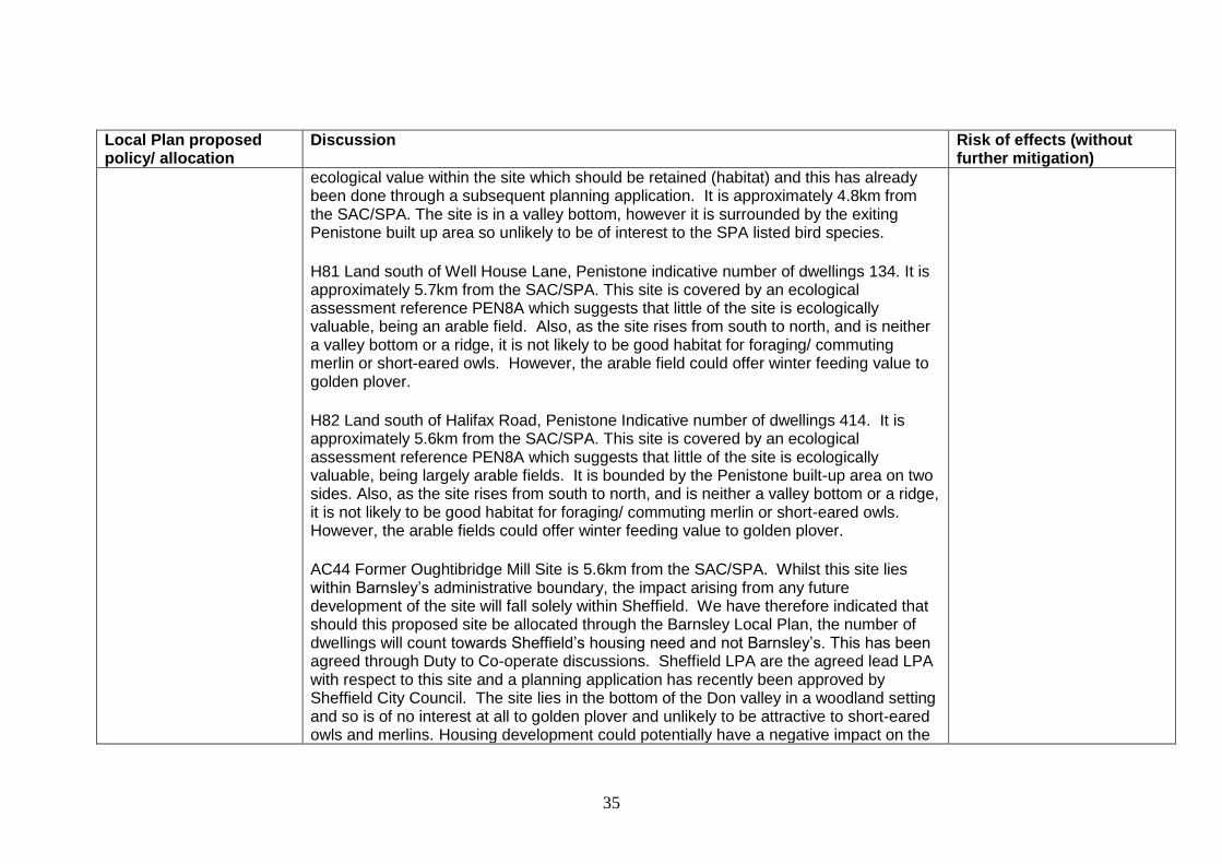
35
Local Plan proposed policy/ allocation
Discussion Risk of effects (without further mitigation)
ecological value within the site which should be retained (habitat) and this has already been done through a subsequent planning application. It is approximately 4.8km from the SAC/SPA. The site is in a valley bottom, however it is surrounded by the exiting Penistone built up area so unlikely to be of interest to the SPA listed bird species.
H81 Land south of Well House Lane, Penistone indicative number of dwellings 134. It is approximately 5.7km from the SAC/SPA. This site is covered by an ecological assessment reference PEN8A which suggests that little of the site is ecologically valuable, being an arable field. Also, as the site rises from south to north, and is neither a valley bottom or a ridge, it is not likely to be good habitat for foraging/ commuting merlin or short-eared owls. However, the arable field could offer winter feeding value to golden plover.
H82 Land south of Halifax Road, Penistone Indicative number of dwellings 414. It is approximately 5.6km from the SAC/SPA. This site is covered by an ecological assessment reference PEN8A which suggests that little of the site is ecologically valuable, being largely arable fields. It is bounded by the Penistone built-up area on two sides. Also, as the site rises from south to north, and is neither a valley bottom or a ridge, it is not likely to be good habitat for foraging/ commuting merlin or short-eared owls. However, the arable fields could offer winter feeding value to golden plover.
AC44 Former Oughtibridge Mill Site is 5.6km from the SAC/SPA. Whilst this site lies within Barnsley’s administrative boundary, the impact arising from any future development of the site will fall solely within Sheffield. We have therefore indicated that should this proposed site be allocated through the Barnsley Local Plan, the number of dwellings will count towards Sheffield’s housing need and not Barnsley’s. This has been agreed through Duty to Co-operate discussions. Sheffield LPA are the agreed lead LPA with respect to this site and a planning application has recently been approved by Sheffield City Council. The site lies in the bottom of the Don valley in a woodland setting and so is of no interest at all to golden plover and unlikely to be attractive to short-eared owls and merlins. Housing development could potentially have a negative impact on the

36
Local Plan proposed policy/ allocation
Discussion Risk of effects (without further mitigation)
sites. The main potential impact of the new houses will be increased recreational pressure on adjacent open areas. As detailed under Greenways above, direct routes to the National Park and the Natura 2000 sites from the western parts of the borough are limited. The remoteness of the Moors means they are unlikely to appeal to the typical urban visitor and new residents of the proposed housing sites are more likely to use locally accessible greenspaces for recreation purposes.
As detailed above under greenspace, we will also require new developments to provide on site greenspace which should be appropriate to the needs of the area, would also meet the recreational needs of new residents and offset any pressure on sensitive areas.
Our Green Space Strategy sets out standards for green space in relation to:
quantity – making sure each town and village has enough green space of each type;
accessibility – how far people should expect to go to get to green spaces; and
quality – the quality of the space people should expect to find.
With regard to the natural and semi-natural areas we have set a standard of a 2ha site within 800m of the settlement. We will aim to meet these standards and in doing so should provide people with access to open areas which are not unduly sensitive to effects.
E2 the distribution of new employment sites
Site P2 Land North of Sheffield Road, Penistone, 3.3ha lies 5.1km from the SAC/SPA. It lies in the bottom of the Don valley directly adjacent to the Springvale built-up area. It is also adjacent to a busy B road and close to Oxspring built-up area and as such is not likely to be attractive to either merlins or short-eared owls. Hence it is not thought that allocation is likely to have an adverse effect on site integrity.
No adverse effects on integrity.
Transport - The Local Strategic Highway Network
The existing local strategic highways network is shown on the Proposals Map with the A628 and the A616 being the main routes within the buffer zone.
No adverse effects on integrity

37
Local Plan proposed policy/ allocation
Discussion Risk of effects (without further mitigation)
Transport modelling has confirmed that the increased traffic flows (passenger car units) generated from the Local Plan proposals and using the A628 west of Millhouse Green is negligible at 30pcu’s and therefore has no implications for increased air pollution along the A628.
There are no specific transportation plans or proposals for the A628 within the Local Plan. Transport proposals in the Local Plan for the west of the Borough are based on improvements to the existing links.
All the policies within the Transport chapter of the Local Plan are based on the premise of sustainable travel, firstly the need to reduce travel but where travel is necessary to make it easy for people to move between home, work, health, community and leisure facilities by walking, cycling or where necessary using public transport.
MIN1 Minerals 3 existing quarries within the buffer zone have extant planning permission for further extraction of minerals:
MIN2 Middlecliff Quarry, Lee Lane, Millhouse Green – 16ha, 3.1km from the SAC/SPA. Permission to extract clay, much of which has already been worked.
MIN5 Hillside Quarry, Cross Lane, Hillside, Thurlstone – 0.8ha, 3.4km from the SAC/SPA. Permission to extract sandstone.
MIN6 Greenley Carr Quarry, Whitley Road, Dunford – 23ha, 4.2km from the SAC/SPA. Permission to extract clay, much of which has already been worked.
These permissions have already gone through determination under previous local planning guidelines including preventing impacts on Natura 2000 sites.
No adverse effects on integrity

38
4.6 The following table 5 sets out the potential impact of policies and land allocations on Natura 2000 Sites after mitigation. Table 5: Mitigation measures relating to policies/ allocations possibly causing adverse effects on site integrity
Local Plan proposed policy/ allocation
Mitigation to prevent adverse effect on site integrity Risk after mitigation
LG2 the location of growth and H2 the distribution of new homes
The Peak District National Park Management Plan 2012-17 recognises that the Government wants to see more opportunities for active recreation in national parks. It includes measures which will mitigate any increased recreational pressures which may affect the designated sites as a result of policies or proposals in the Local Plan. Under Recreation and Tourism recognised actions are to:
Shift emphasis from passive to active recreation provision for visitors and local residents, pursuing, in addition to walking, a targeted promotion of active sports such as cycling, mountain biking, and canoeing in suitable locations and subject to appropriate controls.
Improve recreation routes and link them together where possible to increase opportunities for enjoying the National Park in a sustainable way.
The plan also recognises that the impact of motorised traffic in particular (creating dangerous roads, accidents, visual intrusion, loss of tranquillity, clutter of road signs, air pollution and carbon dioxide emissions and their links to climate change), remains one of the biggest threats to habitats, communities, visitor enjoyment, and quality of the built environment in the National Park. Eighty-five per cent of visitors come by car and most people would regard this not only as their favoured option but their only option even where alternatives do exist. We will continue to work with partners to find and market alternatives to the car wherever practical. Under Traffic, Travel and Accessibility the plan states that by 2011 highways, transport infrastructure and services have been improved because they:
meet the needs of residents, visitors and surrounding areas
increase the proportion of visitors using methods of travel other than private cars
reduce the adverse environmental impacts of travel on the special qualities of the National
No adverse effect on integrity

39
Park
enable more sustainable travel patterns that lead to a reduction in the levels of carbon dioxide emitted into the atmosphere, especially by supporting public transport
A recognised action is to ensure Highway Authority accessibility strategies reflect residents’, visitors’ and surrounding areas’ needs without damage to the National Park. In terms of recreation hotspots such as Langsett Reservoir, Winscar Reservoir and Dunford Bridge/ TPT, it is considered that Langsett – which is possibly at greatest risk from local visitor pressure - may be close to capacity already, whilst Dunford Bridge and Winscar could take more visitors without detrimental effect because they do not encourage users to access the SAC/SPA areas. The Peak District National Park Management Plan HRA considers the likely effects of the Management Plan outcomes on Natura 2000 sites. WI1 states that the National Park will strengthen its role as a welcoming place and premier destination, synonymous with escape, adventure, enjoyment and sustainability. The Assessment states that measures which could increase visitor numbers and associated infrastructure could potentially impact adversely on sites which might receive greater visitor numbers. However it concludes that experience suggests that such situations are likely to be very limited (the area of SSSI in currently unfavourable condition due to increased recreational pressure, for example is 2.4 hectares or 0.005% of the area). The Assessment also considers WI4 Accessible and diverse recreation opportunities will be available for all, encouraging healthy living, enjoyment of the landscape and a sense of adventure. The Assessment considers that measures to manage recreational pressure are likely to have beneficial effects on Natura 2000 sites within the National Park, such as the management of moorland paths reducing erosion and disturbance corridors. The Recreation Forum offers a constructive way for all recreation interests to share views and reach agreements on the best way forward on issues.
Derbyshire County Council produces a Rights of Way Improvement Plan (RoW IP) which covers the whole of the Peak District, including the part that lies within Barnsley. This states that the special qualities of the Peak District moorlands have been recognised through the “Moors for the Future Project”, which was launched in 2002 with the principal aim of reversing the damage caused to large parts of this internationally important area by erosion, pollution, fires and over grazing. The project is
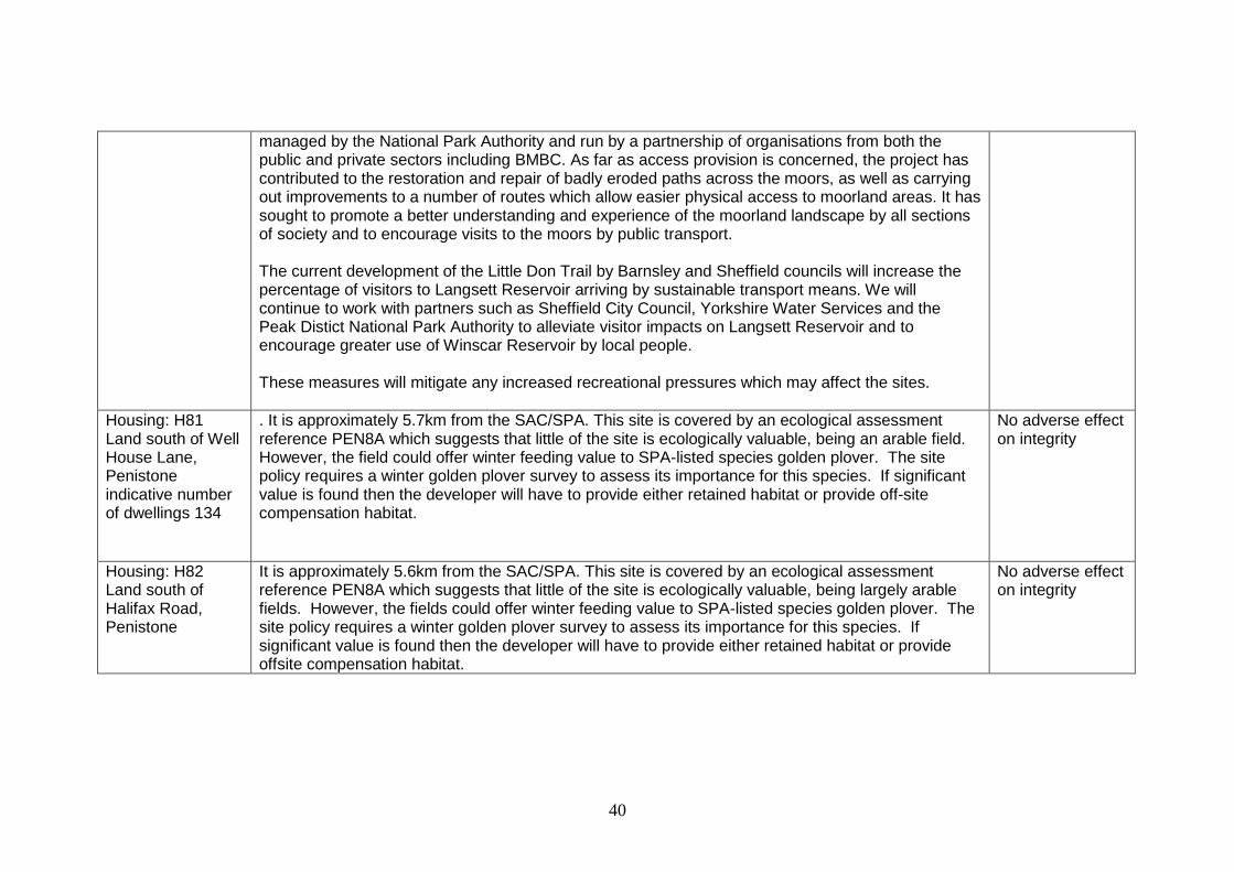
40
managed by the National Park Authority and run by a partnership of organisations from both the public and private sectors including BMBC. As far as access provision is concerned, the project has contributed to the restoration and repair of badly eroded paths across the moors, as well as carrying out improvements to a number of routes which allow easier physical access to moorland areas. It has sought to promote a better understanding and experience of the moorland landscape by all sections of society and to encourage visits to the moors by public transport. The current development of the Little Don Trail by Barnsley and Sheffield councils will increase the percentage of visitors to Langsett Reservoir arriving by sustainable transport means. We will continue to work with partners such as Sheffield City Council, Yorkshire Water Services and the Peak Distict National Park Authority to alleviate visitor impacts on Langsett Reservoir and to encourage greater use of Winscar Reservoir by local people. These measures will mitigate any increased recreational pressures which may affect the sites.
Housing: H81 Land south of Well House Lane, Penistone indicative number of dwellings 134
. It is approximately 5.7km from the SAC/SPA. This site is covered by an ecological assessment reference PEN8A which suggests that little of the site is ecologically valuable, being an arable field. However, the field could offer winter feeding value to SPA-listed species golden plover. The site policy requires a winter golden plover survey to assess its importance for this species. If significant value is found then the developer will have to provide either retained habitat or provide off-site compensation habitat.
No adverse effect on integrity
Housing: H82 Land south of Halifax Road, Penistone
It is approximately 5.6km from the SAC/SPA. This site is covered by an ecological assessment reference PEN8A which suggests that little of the site is ecologically valuable, being largely arable fields. However, the fields could offer winter feeding value to SPA-listed species golden plover. The site policy requires a winter golden plover survey to assess its importance for this species. If significant value is found then the developer will have to provide either retained habitat or provide offsite compensation habitat.
No adverse effect on integrity

41
5. Conclusions
5.1 It is considered that allocations outside the 5 km buffer zone (for housing and employment in particular) will not have any adverse impact on integrity of Natura 2000 sites, rather by focusing development away from these designated sites the proposals could have an indirect positive impact towards protecting them.
5.2None of the sites listed as being within or at the edge of the buffer zone around the Natura 2000 sites are on an obvious flightline which would be attractive to birds named in the SPA citation because they are not on the top of a hill, not in a valley bottom, and they do not have significant wetland features. Birds of prey such as the named short-eared owl and merlin will hunt in other areas but these sites would not be particularly attractive to them.
5.3Two sites are proposed for housing within the buffer zone around the Natura 2000 sites. These housing sites are on the edge of the existing built up area of Penistone and are constrained on their outer edges by the Green Belt. As such their location should help focus potentially harmful development within the settlements. The proposed housing sites are at the furthest reach of the buffer zone at some distance from the Natura 2000 sites and are unlikely to result in any direct loss of feeding habitat. In terms of recreational use, the future residents of these developments are more likely to use nearby local greenspaces minimising any potential impact on the more sensitive designated sites. Whilst some new residents will use Langsett Reservoir and Winscar Reservoir they will tend to prefer facilities closer to and in Penistone Town first such as the Trans Pennine Trail. Langsett Reservoir is already a popular recreational destination, however it is considered that the sites proposed in the Local Plan will not significantly exacerbate this. The sites proposed for housing, and the safeguarded land sites with the exception of those at Thurlstone and Oxspring, are extensions to the Principal Town of Penistone rather than isolated western rural sites.
5.4 In terms of recreation hotspots such as Langsett Reservoir, Winscar Reservoir and Dunford Bridge/ TPT, it is considered that Langsett may be close to capacity already, whilst Dunford Bridge and Winscar could take more visitors without detrimental effect
.
5.5 The reinstatement of the former Woodhead railway line could also potentially have a negative impact on the designated sites and further assessment will be required if it is to be reinstated. However the route is only safeguarded in this plan, and since this potential reinstatement is likely to be outside the plan period it will be a consideration for any subsequent plan. The safeguarding alone will not have a negative effect.
42
5.6 Existing SSSI, LWS and Green Belt allocations cover or adjoin the SAC and SPA. There are also a number of Ancient Woodlands within the buffer zone. All these allocations and the associated policies give a high degree of protection to habitat and ecology and are therefore considered to have positive impacts that will help to preserve the integrity of the SAC and SPA.
5.7 Additionally when the Council determines planning applications the impact of development on the integrity of the Natura 2000 sites is assessed within the process. The Local Plan contains positive policies to protect the SAC and SPA and other designated sites, biodiversity and geodiversity and the environment generally. These will ensure that development which may harm the integrity of the SAC and SPA will not be permitted and are detailed under the relevant designation in Table 3 in Section 4 above.
5.8 Local Plan policy SD1 Presumption in Favour of Sustainable Development states that when considering development proposals we will take a positive approach that reflects the presumption in favour of development contained in the National Planning Policy Framework. It also aims to secure development that improves the economic, social and environmental conditions in the area.
5.9 This screening has highlighted a number of uncertainties some of which have been addressed and the mitigation described in the discussion column of Table 4 in Section 4. In addition to this, as also set out in table 4, The Peak District National Park Management Plan and Derbyshire County Council’s Rights of Way Improvement Plan include measures which will mitigate any increased recreational pressures which may affect the designated sites as a result of the policies or proposals in the Local Plan.
5.10 Overall, it is concluded that the policies and proposed sites within the Local Plan would have no adverse effect onthe Natura 2000 sites, subject to proposed mitigation. The mitigation measures proposed in table 4 above are only capable of being delivered through partnership working. By concentrating development in existing settlements and proposed environmental and habitat protection allocations, the Local Plan will help to protect the integrity of the SAC and SPA.

43
Appendix 1
Barnsley BAP 2008 – 2012
The Barnsley BAP 2008-2012 is still in force. It is currently under review, and it is anticipated that a revised version will be adopted in 2017.
Habitat Action Plan HAP 1 Upland Oakwood Local Status This type is well represented in Barnsley by 30 woodlands. Eight of these are included in the Local Wildlife Site (LWS) register by being of high local value. Mainly found in the west and south-west of the borough, these include: Hollin and Spring Woods at Langsett. Proposed Local Action
Review Ancient Woodland Inventory.
Identify ownership of woodlands.
Survey and complete a register of all Ancient and Veteran Trees.
Encourage landowners to leave deadwood within woods where appropriate.
Local Badger Group to continue to survey and monitor the Badger population.

44
Extract information from the Barnsley Bird Study Group Breeding Bird Survey to provide populations and mapping of breeding Tree Pipit, Lesser Redpoll, Spotted Flycatcher and Wood Warbler.
BMBC Planning Policy Actions
Include habitat and species protection policies in development plans and/or supplementary guidance.
Encourage the creation of new habitat through the requirement made under the NPPF, to incorporate biodiversity enhancements into development wherever possible.
Ensure that Local Plan policies are in place to protect native woodlands.
Designate Local Wildlife Sites (LWS) and declare Local Nature Reserves (LNR) on appropriate areas of Upland Oakwood habitat, or instigate other appropriate measures for their protection.
BMBC Development Control Actions
Consider the impact on native woodlands when assessing planning applications.
Enforce Tree Preservation Orders (TPOs) as appropriate.
Take opportunities through the planning system to restore or create woodlands and explore possibilities of long-term management agreements.
Ensure all planning applications and General Development Orders are adequately assessed in relation to their impact on Upland Oakwood, that loss or damage is avoided and that opportunities for enhancement or creation are considered in relevant planning decisions.
Encourage a review of Permitted Development Rights that currently allow potentially damaging recreational activities for 14 days per year – such as 4-wheel drive trials.
Through planning control or other land use consultation processes, allow no further loss of areas of Upland Oakwood and seek opportunities to enhance existing areas and create new areas through approved development.
Encourage development control teams to use planning conditions and Section 106 agreements to secure improved woodland management related to new development.
BMBC Land Ownership and Management Actions
Barnsley MBC countryside sites to be managed so as to contribute to Biodiversity Action Plan (BAP) Upland Oakwood targets.
Habitat Action Plan HAP 11
Upland Heathland

45
Local Status Most of the Upland Heathland is within the Peak District National Park in Barnsley, and there are a total of 14 sites identified. Proposed Local Action
Provide an inventory of Upland Heathland sites, their status and ownership.
Encourage participation among farmers in Environmental Stewardship and Countryside Stewardship Schemes.
Encourage the appropriate management of Upland Heathland, including works beneficial to Bumble Bees.
Survey and monitor all known Green Hairstreak sites.
Extract past records, survey and monitor Mountain Hare.
Extract any past records, survey and monitor for Adder and Common Lizard.
Extract information from the Barnsley Bird Study Group Breeding Bird Survey to provide populations and mapping of breeding Red Grouse, Curlew, Nightjar, Cuckoo, and Ring Ouzel and Twite.
BMBC Planning Policy Actions
Encourage the creation of new habitat through the requirement made under the NPPF to incorporate biodiversity enhancements into development wherever possible.
BMBC Land Ownership and Management Actions
Work with Coalfield Heathland Project to identify and develop new western gorse Upland Heathland sites on Barnsley MBC owned land.
Habitat Action Plan HAP12
Blanket Bog
Local Status Blanket Bogs or mires in the Barnsley district are mostly (but not entirely) located within the Peak District National Park to the west of the borough. Proposed Local Action
Maintain the current extent of the resource. Define favourable condition, locate any examples and ensure all zones are in a management regime that will maintain favourable status. Lead partner: Natural England
Introduce/maintain management regimes to improve condition to ensure it is in or approaching favourable condition. Lead partner: Natural England

46
Introduce/maintain management regimes to improve, and if possible subsequently maintain in favourable condition. Lead partner: Natural England
Gather information on Blanket Bog habitats not covered by statutory designations outside the Peak District National Park and develop conservation plans in conjunction with owners if appropriate.
Extract information from the Barnsley Bird Study Group Breeding Bird Survey to provide populations and mapping of breeding Curlew, Dunlin and Golden Plover.
Extract past records, survey and monitor Mountain Hare.
Extract any past records, survey and monitor for Common Lizard. Habitat Action Plan HAP13 Purple Moor Grass and Rush Pasture Local Status The areas within Barnsley are possibly not classified as pure Rush Pastures, but are fragmented remnants and often a hybrid of other related habitats. However, this may make this habitat even more important for conserving in the area, especially due to key associated species such as Brown Hare, Curlew, Snipe, Lapwing and Skylark. Pockets of this habitat occur in Barnsley across the broad swathe of land between Ingbirchworth, Crow Edge and Langsett. Proposed Local Action
Continue to monitor the population of Brown Hare and encourage appropriate management.
Extract information from the Barnsley Bird Study Group Breeding Bird Survey to provide populations and mapping of breeding Curlew and Reed Bunting.
Encourage participation among farmers in Environmental Stewardship and Countryside Stewardship Schemes.
Habitat Action Plan HAP16 Rivers
Local Status

47
The district is drained by two main Rivers, the Dearne and the Don, both of which have a number of important tributaries. Much of the character of the district derives from the pattern of hills and dales bisected with small streams and woodlands. Proposed Local Action
Encourage participation among farmers in Environmental Stewardship and Countryside Stewardship Schemes.
Identify target areas for habitat enhancement, particularly the restoration of riparian vegetation on bare sections of river bank.
Monitor Rivers for the presence of Otter, Water Vole, Eel, Salmon, Brown Trout, Bullhead and White-clawed Crayfish.
Work with Barnsley MBC to create a Local Plan supplementary planning document on Biodiversity and Waterfront Development and Management.
These should including the expectation that opportunities will be sought to improve and create habitat for species such as Water Vole and Otter, rather than just slow the loss of habitat. A proactive planning approach should be adopted to retain native bank side cover, including dense brambles and scrub, and control invasive plants when brown field sites are redeveloped. BMBC Planning Policy Actions
Agree methodology for the evaluation of river corridors and river corridor habitats and the identification of ‘Wildlife Sites’. Include methodology for evaluating sites for conservation, restoration and re-creation, with reference to key habitats; key sites for important species the importance of creating linkages and corridors between habitats.
Encourage the creation of new habitat through the requirement made under the NPPF to incorporate biodiversity enhancements into development wherever possible.
BMBC Development Control Actions
Ensure that all proposed development likely to impact upon river systems is minimised and mitigated against. BMBC Land Ownership and Management Actions
Design and implement habitat improvement programmes on the most suitable stretches of river. Develop whole river restoration schemes.