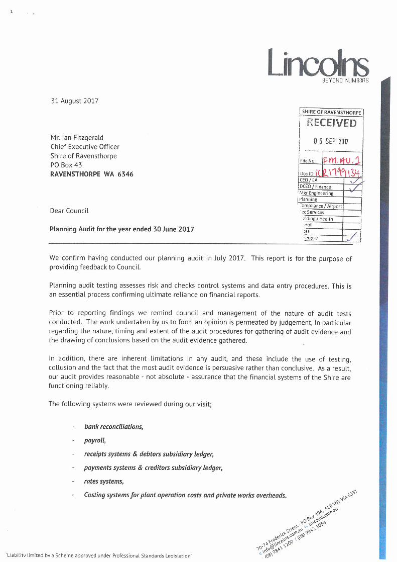
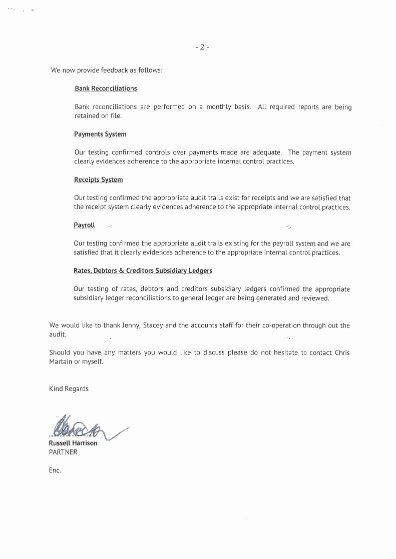
Bank INV No Date Name Invoice Description Code … · 161 11/08/2017 Bridgestone - Albany Combined...
207
Date: Time: 2:43:41PM Shire of Ravensthorpe USER: Eimear Guidera PAGE: 1 08/09/2017 Creditors Payments August 2017 Cheque /EFT No Date Name Invoice Description Bank Code Amount INV Amount 1 STREET LIGHTING HOPETOUN 01/07/17 - 31/07/17 Horizon Power 04/08/2017 3,174.59 156 LOT 314 MAITLAND STREET 26/05/17 - 27/07/17 Horizon Power 28/07/2017 INV 397872 57.21 STREET LIGHTING HOPETOUN 01/07/17 - 31/07/17 Horizon Power 31/07/2017 INV 136499 2,789.65 79 ESPLANADE 30/06/17 - 25/07/17 Horizon Power 27/07/2017 INV 442429 67.61 LOT 461 CANNING BOULEVARD 25/05/17 - 26/07/17 Horizon Power 27/07/2017 INV 185210 31.84 LOT 245 VEAL STREET 25/05/17 - 26/07/17 Horizon Power 27/07/2017 INV 137406 171.04 LOT 548 TAMAR STREET 23/05/17 - 24/07/17 Horizon Power 25/07/2017 INV 267634 57.24 1 Payroll deductions Shire of Ravensthorpe 04/08/2017 500.00 157 Payroll deductions Shire of Ravensthorpe 02/08/2017 INV DEDUCT 400.00 Payroll deductions Shire of Ravensthorpe 02/08/2017 INV DEDUCT 100.00 1 SATELLITE PHONES 22 JUL TO 21 AUG Telstra 04/08/2017 175.00 158 SATELLITE PHONES 22 JUL TO 21 AUG Telstra 22/07/2017 INV T311 175.00 1 TRADE WASTE PERMIT VEAL STREET 01/07/17 - 30/06/18 Water Corporation 04/08/2017 331.92 159 TRADE WASTE PERMIT VEAL STREET 01/07/17 - 30/06/18 Water Corporation 12/07/2017 INV 902062670 331.92 1 TOTAL SUPPLY PERIOD ENDING 31/07/17 Australia Post 11/08/2017 1.97 160 TOTAL SUPPLY PERIOD ENDING 31/07/17 Australia Post 03/08/2017 INV 100663768 1.97 1 TYRE REPAIRS, NEW TYRES, RIMS, TYRE RESEAL, WHEEL ALIGNMENT Bridgestone - Albany Combined Tyres 11/08/2017 1,305.00 161 TYRE REPAIRS, NEW TYRES, RIMS, TYRE RESEAL, WHEEL ALIGNMENT Bridgestone - Albany Combined Tyres 26/07/2017 INV 98916 1,305.00 1 LOT 694 BEACON DRIVE 02/06/17 - 01/08/17 Horizon Power 11/08/2017 760.94 162 LOT 694 BEACON DRIVE 02/06/17 - 01/08/17 Horizon Power 03/08/2017 INV 224027 760.94 1 LOC 80 JERDACUTTUP ROAD 08/06/17 - 04/08/17 Horizon Power 17/08/2017 680.97 163
Transcript of Bank INV No Date Name Invoice Description Code … · 161 11/08/2017 Bridgestone - Albany Combined...

Date:
Time: 2:43:41PM
Shire of Ravensthorpe USER: Eimear GuideraPAGE: 1
08/09/2017
Creditors Payments August 2017
Cheque /EFT
No Date Name Invoice Description
Bank
Code Amount
INV
Amount
1STREET LIGHTING HOPETOUN 01/07/17 - 31/07/17Horizon Power04/08/2017 3,174.59156
LOT 314 MAITLAND STREET 26/05/17 - 27/07/17Horizon Power28/07/2017INV 397872 57.21
STREET LIGHTING HOPETOUN 01/07/17 - 31/07/17Horizon Power31/07/2017INV 136499 2,789.65
79 ESPLANADE 30/06/17 - 25/07/17Horizon Power27/07/2017INV 442429 67.61
LOT 461 CANNING BOULEVARD 25/05/17 - 26/07/17Horizon Power27/07/2017INV 185210 31.84
LOT 245 VEAL STREET 25/05/17 - 26/07/17Horizon Power27/07/2017INV 137406 171.04
LOT 548 TAMAR STREET 23/05/17 - 24/07/17Horizon Power25/07/2017INV 267634 57.24
1Payroll deductionsShire of Ravensthorpe04/08/2017 500.00157
Payroll deductionsShire of Ravensthorpe02/08/2017INV DEDUCTION 400.00
Payroll deductionsShire of Ravensthorpe02/08/2017INV DEDUCTION 100.00
1SATELLITE PHONES 22 JUL TO 21 AUGTelstra04/08/2017 175.00158
SATELLITE PHONES 22 JUL TO 21 AUGTelstra22/07/2017INV T311 175.00
1TRADE WASTE PERMIT VEAL STREET 01/07/17 - 30/06/18Water Corporation04/08/2017 331.92159
TRADE WASTE PERMIT VEAL STREET 01/07/17 - 30/06/18Water Corporation12/07/2017INV 9020626706-0006 331.92
1TOTAL SUPPLY PERIOD ENDING 31/07/17Australia Post11/08/2017 1.97160
TOTAL SUPPLY PERIOD ENDING 31/07/17Australia Post03/08/2017INV 1006637685 1.97
1TYRE REPAIRS, NEW TYRES, RIMS, TYRE RESEAL,
WHEEL ALIGNMENT
Bridgestone - Albany Combined Tyres11/08/2017 1,305.00161
TYRE REPAIRS, NEW TYRES, RIMS, TYRE RESEAL,
WHEEL ALIGNMENT
Bridgestone - Albany Combined Tyres26/07/2017INV 98916 1,305.00
1LOT 694 BEACON DRIVE 02/06/17 - 01/08/17Horizon Power11/08/2017 760.94162
LOT 694 BEACON DRIVE 02/06/17 - 01/08/17Horizon Power03/08/2017INV 224027 760.94
1LOC 80 JERDACUTTUP ROAD 08/06/17 - 04/08/17Horizon Power17/08/2017 680.97163

Date:
Time: 2:43:41PM
Shire of Ravensthorpe USER: Eimear GuideraPAGE: 2
08/09/2017
Creditors Payments August 2017
Cheque /EFT
No Date Name Invoice Description
Bank
Code Amount
INV
Amount
LOC 80 JERDACUTTUP ROAD 08/06/17 - 04/08/17Horizon Power07/08/2017INV 308541 680.97
1Payroll deductionsShire of Ravensthorpe17/08/2017 500.00164
Payroll deductionsShire of Ravensthorpe16/08/2017INV DEDUCTION 400.00
Payroll deductionsShire of Ravensthorpe16/08/2017INV DEDUCTION 100.00
1STREETLIGHTS 03/07/17 - 01/08/17Synergy17/08/2017 1,288.30165
STREETLIGHTS 03/07/17 - 01/08/17Synergy01/08/2017INV 2184400427 1,288.30
1STANDPIPE AT 32 DUNN STREETWater Corporation17/08/2017 21.27166
STANDPIPE AT 32 DUNN STREETWater Corporation31/07/2017INV 9007746607-0318 21.27
1RAVY RECREATION COMPLEX 18/07/17 - 14/08/17Synergy28/08/2017 1,523.20167
RAVY RECREATION COMPLEX 18/07/17 - 14/08/17Synergy15/08/2017INV 2108381992 1,523.20
1TOILETS AT TUBADA ST MUNGLINUPWater Corporation28/08/2017 254.60168
STANDPIPE AT 9 MORRELL ST MUNGLINUPWater Corporation08/08/2017INV 9007779716-0121 71.86
TOILETS AT TUBADA ST MUNGLINUPWater Corporation08/08/2017INV 9007779724 182.74
1PUMP OUT STORMWATER CHAMBERS4 Rivers Plumbing & Gas04/08/2017 1,683.00EFT7417
PUMP OUT STORMWATER CHAMBERS4 Rivers Plumbing & Gas26/07/2017INV 3426 1,683.00
1DEBT RECOVERY COSTS FOR JULY 2017AMPAC Debt Recovery04/08/2017 616.00EFT7418
DEBT RECOVERY COSTS FOR JULY 2017AMPAC Debt Recovery31/07/2017INV 40543 616.00
1AERODROME REPORTING OFFICER TRAINING - STACEY
JASKIEWICZ
Aerodrome Management Services Pty Ltd (AMS)04/08/2017 2,400.00EFT7419
AERODROME REPORTING OFFICER TRAINING - STACEY
JASKIEWICZ
Aerodrome Management Services Pty Ltd (AMS)01/08/2017INV AMSINV-04756 2,400.00
1HEMA NAVIGATORAlbany Automotive Group T/As Albany 4WD and
Camping Centre
04/08/2017 644.25EFT7420

Date:
Time: 2:43:41PM
Shire of Ravensthorpe USER: Eimear GuideraPAGE: 3
08/09/2017
Creditors Payments August 2017
Cheque /EFT
No Date Name Invoice Description
Bank
Code Amount
INV
Amount
HEMA NAVIGATORAlbany Automotive Group T/As Albany 4WD and
Camping Centre
28/07/2017INV 1440000 644.25
130,000KM SERVICE 0RAAlbany Toyota04/08/2017 497.83EFT7421
30,000KM SERVICE 0RAAlbany Toyota24/07/2017INV JC14026142 497.83
1GOLD MEMBERSHIP 2017 - 2018Australia Day Council of WA04/08/2017 550.00EFT7422
GOLD MEMBERSHIP 2017 - 2018Australia Day Council of WA24/07/2017INV 2880 550.00
1ASSISTANCE WITH THE 17/18 ANNUAL BUDGETBob Waddell & Associates Pty Ltd04/08/2017 1,650.00EFT7423
ASSISTANCE WITH THE 17/18 ANNUAL BUDGETBob Waddell & Associates Pty Ltd31/07/2017INV 1134 1,650.00
13 X CARTONS OF BAGSChefmaster Australia04/08/2017 523.85EFT7424
3 X CARTONS OF BAGSChefmaster Australia24/07/2017INV 20018 523.85
1DEBTORS REFUND - OVERPAYMENT OF INVOICE #1997Chris Fisher04/08/2017 69.00EFT7425
DEBTORS REFUND - OVERPAYMENT OF INVOICE #1997Chris Fisher03/08/2017INV REFUND 69.00
1ADVERTISING - PLANT & EQUIPMENT HIRECommunity Spirit Newspaper Inc04/08/2017 90.00EFT7426
ADVERTISING - PLANT & EQUIPMENT HIRECommunity Spirit Newspaper Inc27/07/2017INV 21301 90.00
1SYSTEM RENTAL 16/07/17 - 15/10/17Connect Technology Australia04/08/2017 1,295.22EFT7427
SYSTEM RENTAL 16/07/17 - 15/10/17Connect Technology Australia27/07/2017INV 71446 1,295.22
1BINDING & DELIVERY OF COUNCIL MINUTESFast Finishing Services04/08/2017 239.69EFT7428
BINDING & DELIVERY OF COUNCIL MINUTESFast Finishing Services14/07/2017INV 56651 239.69
1ANNUAL SUBSCRIPTION FOR AWARDS-ON-DISK &
AWARD INTERPRETATION SERVICE
Fitzgerald Strategies04/08/2017 606.95EFT7429
ANNUAL SUBSCRIPTION FOR AWARDS-ON-DISK &
AWARD INTERPRETATION SERVICE
Fitzgerald Strategies01/07/2017INV 1834 606.95
1TRAVEL, SURVEY TREES AND COMPILE REPORTGreenman Trading Co.04/08/2017 1,683.00EFT7430

Date:
Time: 2:43:41PM
Shire of Ravensthorpe USER: Eimear GuideraPAGE: 4
08/09/2017
Creditors Payments August 2017
Cheque /EFT
No Date Name Invoice Description
Bank
Code Amount
INV
Amount
TRAVEL, SURVEY TREES AND COMPILE REPORTGreenman Trading Co.25/07/2017INV 2477 1,683.00
1BUSINESS CARDS FOR STACEY JASKIEWICZGuardian Print & Graphics04/08/2017 150.00EFT7431
BUSINESS CARDS FOR STACEY JASKIEWICZGuardian Print & Graphics26/07/2017INV 6019 150.00
1PROFESSIONAL SERVICES (2016) FOR HOPETOUN
COMMUNITY CENTRE
H+H Architects04/08/2017 5,236.00EFT7432
PROFESSIONAL SERVICES (2016) FOR HOPETOUN
COMMUNITY CENTRE
H+H Architects01/08/2017INV 4586 5,236.00
1MANNING HOPETOUN TRANSFER STATION JULY 2017Hopetoun Men In Sheds Incorporated04/08/2017 1,500.00EFT7433
MANNING HOPETOUN TRANSFER STATION JULY 2017Hopetoun Men In Sheds Incorporated31/07/2017INV 214 1,500.00
1NAMS PLUS SUBSCRIPTION 01/07/17 - 30/06/18Institute of Public Works Engineering Australasia
Limited
04/08/2017 792.00EFT7434
NAMS PLUS SUBSCRIPTION 01/07/17 - 30/06/18Institute of Public Works Engineering Australasia
Limited
28/06/2017INV 84116-NP0617 792.00
1RANGER UNIFORMJR & A Hersey Pty Ltd04/08/2017 352.67EFT7435
RANGER UNIFORMJR & A Hersey Pty Ltd31/07/2017INV 00A39821 352.67
1SUPPLY OF 2509 TONNE LIMESTONE & 3412 TONNE SANDKrystal Park Estate- Hopetoun04/08/2017 24,065.80EFT7436
SUPPLY OF 2509 TONNE LIMESTONE & 3412 TONNE SANDKrystal Park Estate- Hopetoun25/07/2017INV 25/07/17 24,065.80
1ANALYTICAL SERVICES 2017/2018Local Health Authorities Analytical Committee
(LHAAC)
04/08/2017 544.45EFT7437
ANALYTICAL SERVICES 2017/2018Local Health Authorities Analytical Committee
(LHAAC)
24/07/2017INV MA2017 105 544.45
1CERA TRAPS 1LT & 5LTMIRCO BROS04/08/2017 6,318.40EFT7438
CERA TRAPS 1LT & 5LTMIRCO BROS26/07/2017INV 3314111 6,318.40
1CLEANING & GENERAL UPKEEP OF TOILETS JULY 2017Munglinup Roadhouse04/08/2017 880.00EFT7439
CLEANING & GENERAL UPKEEP OF TOILETS JULY 2017Munglinup Roadhouse31/07/2017INV 5 880.00
Date:
Time: 2:43:41PM
Shire of Ravensthorpe USER: Eimear GuideraPAGE: 5
08/09/2017
Creditors Payments August 2017
Cheque /EFT
No Date Name Invoice Description
Bank
Code Amount
INV
Amount
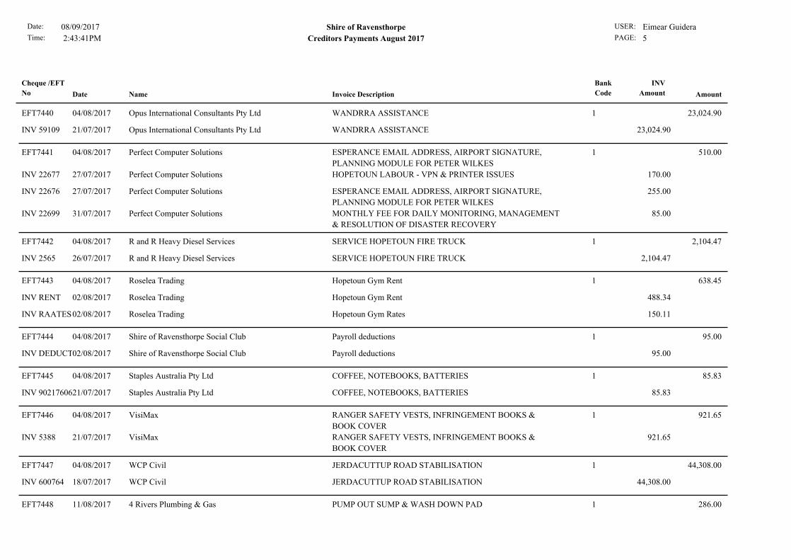
1WANDRRA ASSISTANCEOpus International Consultants Pty Ltd04/08/2017 23,024.90EFT7440
WANDRRA ASSISTANCEOpus International Consultants Pty Ltd21/07/2017INV 59109 23,024.90
1ESPERANCE EMAIL ADDRESS, AIRPORT SIGNATURE,
PLANNING MODULE FOR PETER WILKES
Perfect Computer Solutions04/08/2017 510.00EFT7441
HOPETOUN LABOUR - VPN & PRINTER ISSUESPerfect Computer Solutions27/07/2017INV 22677 170.00
ESPERANCE EMAIL ADDRESS, AIRPORT SIGNATURE,
PLANNING MODULE FOR PETER WILKES
Perfect Computer Solutions27/07/2017INV 22676 255.00
MONTHLY FEE FOR DAILY MONITORING, MANAGEMENT
& RESOLUTION OF DISASTER RECOVERY
Perfect Computer Solutions31/07/2017INV 22699 85.00
1SERVICE HOPETOUN FIRE TRUCKR and R Heavy Diesel Services04/08/2017 2,104.47EFT7442
SERVICE HOPETOUN FIRE TRUCKR and R Heavy Diesel Services26/07/2017INV 2565 2,104.47
1Hopetoun Gym RentRoselea Trading04/08/2017 638.45EFT7443
Hopetoun Gym RentRoselea Trading02/08/2017INV RENT 488.34
Hopetoun Gym RatesRoselea Trading02/08/2017INV RAATES 150.11
1Payroll deductionsShire of Ravensthorpe Social Club04/08/2017 95.00EFT7444
Payroll deductionsShire of Ravensthorpe Social Club02/08/2017INV DEDUCTION 95.00
1COFFEE, NOTEBOOKS, BATTERIESStaples Australia Pty Ltd04/08/2017 85.83EFT7445
COFFEE, NOTEBOOKS, BATTERIESStaples Australia Pty Ltd21/07/2017INV 9021760604 85.83
1RANGER SAFETY VESTS, INFRINGEMENT BOOKS &
BOOK COVER
VisiMax04/08/2017 921.65EFT7446
RANGER SAFETY VESTS, INFRINGEMENT BOOKS &
BOOK COVER
VisiMax21/07/2017INV 5388 921.65
1JERDACUTTUP ROAD STABILISATIONWCP Civil04/08/2017 44,308.00EFT7447
JERDACUTTUP ROAD STABILISATIONWCP Civil18/07/2017INV 600764 44,308.00
1PUMP OUT SUMP & WASH DOWN PAD4 Rivers Plumbing & Gas11/08/2017 286.00EFT7448

Date:
Time: 2:43:41PM
Shire of Ravensthorpe USER: Eimear GuideraPAGE: 6
08/09/2017
Creditors Payments August 2017
Cheque /EFT
No Date Name Invoice Description
Bank
Code Amount
INV
Amount
PUMP OUT SUMP & WASH DOWN PAD4 Rivers Plumbing & Gas26/07/2017INV 3427 286.00
1PACVAC VACCUM CLEANERABCO Products11/08/2017 537.61EFT7449
PACVAC VACCUM CLEANERABCO Products07/08/2017INV 300320 537.61
1CALIBRATION OF PAPI CLINOMETERAirport Lighting Specialists Pty Ltd11/08/2017 319.00EFT7450
CALIBRATION OF PAPI CLINOMETERAirport Lighting Specialists Pty Ltd04/08/2017INV IN18253 319.00
1BOTTLE RENTAL 28/06/17 - 28/07/17BOC Limited11/08/2017 35.29EFT7451
BOTTLE RENTAL 28/06/17 - 28/07/17BOC Limited29/07/2017INV 4016889751 35.29
1FUEL ACCOUNT JULY 2017BP Australia Pty Ltd11/08/2017 1,302.73EFT7452
FUEL ACCOUNT JULY 2017BP Australia Pty Ltd31/07/2017INV 9856990 1,302.73
1ASSISTANCE WITH 17/18 ANNUAL BUDGETBob Waddell & Associates Pty Ltd11/08/2017 132.00EFT7453
ASSISTANCE WITH 17/18 ANNUAL BUDGETBob Waddell & Associates Pty Ltd05/08/2017INV 1144 132.00
1REFUND FOR OVERPAYMENT OF RENT 01/07/17 - 30/06/17Broadcast Australia11/08/2017 157.67EFT7454
REFUND FOR OVERPAYMENT OF RENT 01/07/17 - 30/06/17Broadcast Australia08/08/2017INV REFUND 157.67
1FILTER KITCJD Equipment11/08/2017 2,041.23EFT7455
PLAIN BEARING OIL MODULECJD Equipment25/07/2017INV 1554113 48.37
ELEMENT A, LUBE FILTER, FILTERCJD Equipment25/07/2017INV 1554114 185.37
FILTER KITCJD Equipment25/07/2017INV 1554121 456.86
FILTER KITCJD Equipment25/07/2017INV 1554120 456.86
FILTER KITCJD Equipment25/07/2017INV 1553969 181.98
FILTER KITCJD Equipment25/07/2017INV 1553971 218.96
FILTER KITCJD Equipment25/07/2017INV 1553972 158.75
FILTER KITCJD Equipment25/07/2017INV 15539733 152.10

Date:
Time: 2:43:41PM
Shire of Ravensthorpe USER: Eimear GuideraPAGE: 7
08/09/2017
Creditors Payments August 2017
Cheque /EFT
No Date Name Invoice Description
Bank
Code Amount
INV
Amount
FILTER KITCJD Equipment25/07/2017INV 1553970 181.98
1COLLECTIONS FOR JULY 2017Cleanaway Pty Ltd11/08/2017 17,191.10EFT7456
COLLECTIONS FOR JULY 2017Cleanaway Pty Ltd31/07/2017INV 9760391 16,333.10
3 X 12 MTH 240LT CONTRACT FEECleanaway Pty Ltd31/07/2017INV 9758597 858.00
1COURIER AUSTRALIA - JASON SIGNS,
KENWORTH,WESTRAC, JTB SPARES, AIRPORT LIGHTING,
PATHWEST
Courier Australia11/08/2017 639.98EFT7457
COURIER AUSTRALIA - JR HERSEYCourier Australia14/07/2017INV 0318 20.15
COURIER AUSTRALIA - JASON SIGNS, WESTRACCourier Australia21/07/2017INV 319 48.17
COURIER AUSTRALIA - JASON SIGNS,
KENWORTH,WESTRAC, JTB SPARES, AIRPORT LIGHTING,
PATHWEST
Courier Australia28/07/2017INV 0320 571.66
1REMOUNT STARTING MOTOR DOZERDay and Nite Maintenance11/08/2017 3,032.40EFT7458
DOZER STARTING PROBLEMSDay and Nite Maintenance07/07/2017INV 751/1 198.00
SERVICE HILUX RA222Day and Nite Maintenance04/07/2017INV 751/2 339.90
SERVICE HILUXDay and Nite Maintenance21/07/2017INV 751/3 522.50
REMOUNT STARTING MOTOR DOZERDay and Nite Maintenance18/07/2017INV 751/4 1,012.00
SERVICE GRADERDay and Nite Maintenance20/07/2017INV 751/5 517.00
CHECK OIL PRESSURE SYSTEM DAF PRIME MOVERDay and Nite Maintenance27/07/2017INV 751/6 407.00
REPAIR TYREDay and Nite Maintenance28/07/2017INV 751/7 36.00
1GOVERNMENT GAZETTE RANGER NOTICES X 2Department of Premier & Cabinet11/08/2017 205.10EFT7459
GOVERNMENT GAZETTE RANGER NOTICES X 2Department of Premier & Cabinet26/07/2017INV 160343 205.10
1VARIATION IN LICENCE FEES 1BSB370Department of Transport (Shire Licensing)11/08/2017 15.65EFT7460
VARIATION IN LICENCE FEES 1BSB370Department of Transport (Shire Licensing)04/08/2017INV 86624679 15.65
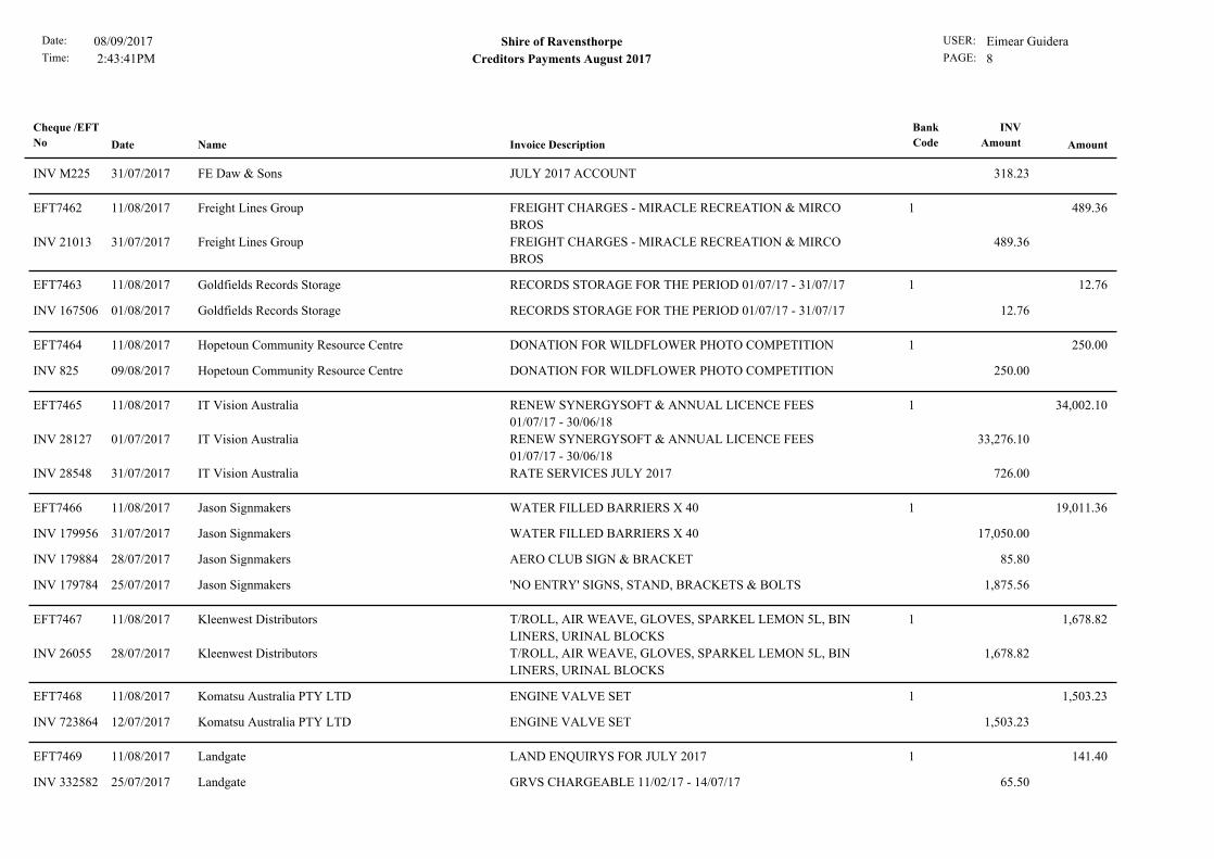
1JULY 2017 ACCOUNTFE Daw & Sons11/08/2017 318.23EFT7461
Date:
Time: 2:43:41PM
Shire of Ravensthorpe USER: Eimear GuideraPAGE: 8
08/09/2017
Creditors Payments August 2017
Cheque /EFT
No Date Name Invoice Description
Bank
Code Amount
INV
Amount
JULY 2017 ACCOUNTFE Daw & Sons31/07/2017INV M225 318.23
1FREIGHT CHARGES - MIRACLE RECREATION & MIRCO
BROS
Freight Lines Group11/08/2017 489.36EFT7462
FREIGHT CHARGES - MIRACLE RECREATION & MIRCO
BROS
Freight Lines Group31/07/2017INV 21013 489.36
1RECORDS STORAGE FOR THE PERIOD 01/07/17 - 31/07/17Goldfields Records Storage11/08/2017 12.76EFT7463
RECORDS STORAGE FOR THE PERIOD 01/07/17 - 31/07/17Goldfields Records Storage01/08/2017INV 167506 12.76
1DONATION FOR WILDFLOWER PHOTO COMPETITIONHopetoun Community Resource Centre11/08/2017 250.00EFT7464
DONATION FOR WILDFLOWER PHOTO COMPETITIONHopetoun Community Resource Centre09/08/2017INV 825 250.00
1RENEW SYNERGYSOFT & ANNUAL LICENCE FEES
01/07/17 - 30/06/18
IT Vision Australia11/08/2017 34,002.10EFT7465
RENEW SYNERGYSOFT & ANNUAL LICENCE FEES
01/07/17 - 30/06/18
IT Vision Australia01/07/2017INV 28127 33,276.10
RATE SERVICES JULY 2017IT Vision Australia31/07/2017INV 28548 726.00
1WATER FILLED BARRIERS X 40Jason Signmakers11/08/2017 19,011.36EFT7466
WATER FILLED BARRIERS X 40Jason Signmakers31/07/2017INV 179956 17,050.00
AERO CLUB SIGN & BRACKETJason Signmakers28/07/2017INV 179884 85.80
'NO ENTRY' SIGNS, STAND, BRACKETS & BOLTSJason Signmakers25/07/2017INV 179784 1,875.56
1T/ROLL, AIR WEAVE, GLOVES, SPARKEL LEMON 5L, BIN
LINERS, URINAL BLOCKS
Kleenwest Distributors11/08/2017 1,678.82EFT7467
T/ROLL, AIR WEAVE, GLOVES, SPARKEL LEMON 5L, BIN
LINERS, URINAL BLOCKS
Kleenwest Distributors28/07/2017INV 26055 1,678.82
1ENGINE VALVE SETKomatsu Australia PTY LTD11/08/2017 1,503.23EFT7468
ENGINE VALVE SETKomatsu Australia PTY LTD12/07/2017INV 723864 1,503.23
1LAND ENQUIRYS FOR JULY 2017Landgate11/08/2017 141.40EFT7469
GRVS CHARGEABLE 11/02/17 - 14/07/17Landgate25/07/2017INV 332582 65.50

Date:
Time: 2:43:41PM
Shire of Ravensthorpe USER: Eimear GuideraPAGE: 9
08/09/2017
Creditors Payments August 2017
Cheque /EFT
No Date Name Invoice Description
Bank
Code Amount
INV
Amount
LAND ENQUIRYS FOR JULY 2017Landgate02/08/2017INV 785166 75.90
1FITZGERALD COAST TOURISM ASSOCIATION
INSURANCE RENEWAL
Local Community Insurance Services11/08/2017 1,370.34EFT7470
FITZGERALD COAST TOURISM ASSOCIATION
INSURANCE RENEWAL
Local Community Insurance Services02/08/2017INV 67441643418 1,370.34
1SITE SUPPORT AUGUST 2017MedTech Healthcare11/08/2017 370.84EFT7471
SITE SUPPORT AUGUST 2017MedTech Healthcare01/08/2017INV 045584 370.84
1JULY 2017 ACCOUNTMeridian Agencies11/08/2017 178.85EFT7472
JULY 2017 ACCOUNTMeridian Agencies04/08/2017INV JULY 2017 178.85
1CHILDCARE BACKUP, INTERNET CONNECTION IN
HOPETOUN, RECEIPTING ERROR
Perfect Computer Solutions11/08/2017 467.50EFT7473
CHILDCARE BACKUP, INTERNET CONNECTION IN
HOPETOUN, RECEIPTING ERROR
Perfect Computer Solutions03/08/2017INV 22723 467.50
1REPAIR SIDE TIPPERR and R Heavy Diesel Services11/08/2017 467.50EFT7474
REPAIR SIDE TIPPERR and R Heavy Diesel Services24/07/2017INV 2564 467.50
1GREASE BLUERavensthorpe Agencies11/08/2017 126.50EFT7475
GREASE BLUERavensthorpe Agencies31/07/2017INV 17296 126.50
1SEMI SIDE TIPPERS - MACHINE HIRE, LOAD & CART
LIMESTONE
Ravensthorpe Bulk Haulage11/08/2017 11,385.00EFT7476
SEMI SIDE TIPPERS - MACHINE HIRE, LOAD & CART
LIMESTONE
Ravensthorpe Bulk Haulage10/08/2017INV 1101 11,385.00
1BOBCAT TYRE SUPPLY & FITRavensthorpe Mechanical Services11/08/2017 922.77EFT7477
BOBCAT TYRE SUPPLY & FITRavensthorpe Mechanical Services01/07/2017INV 30787 564.20
FABRICATE HYDRAULIC HOSERavensthorpe Mechanical Services04/07/2017INV 30803 358.57
1PLANNING OFFICER 12HRS & MANAGER PLANNING 4HRSShire Of Esperance11/08/2017 3,960.00EFT7478
PLANNING OFFICER 12HRS & MANAGER PLANNING 4HRSShire Of Esperance03/08/2017INV 58681 3,960.00

Date:
Time: 2:43:41PM
Shire of Ravensthorpe USER: Eimear GuideraPAGE: 10
08/09/2017
Creditors Payments August 2017
Cheque /EFT
No Date Name Invoice Description
Bank
Code Amount
INV
Amount
1PULSATRON LBC452-VTC3-124Sigma Chemicals11/08/2017 981.75EFT7479
PULSATRON LBC452-VTC3-124Sigma Chemicals01/08/2017INV 101926/01 1,179.75
CREDIT NOTE - 4 X DRUM POLY, 1 X PALLETSigma Chemicals01/08/2017INV 380158CN -198.00
1ANNUAL FEE FOR LOST & DAMAGED LIBRARY
MATERIALS 2017/2018
State Library of Western Australia11/08/2017 577.50EFT7480
ANNUAL FEE FOR LOST & DAMAGED LIBRARY
MATERIALS 2017/2018
State Library of Western Australia31/07/2017INV RI017150 440.00
DELIVERY OF BETTER BEGINNINGS PROGRAM 2017/2018State Library of Western Australia26/07/2017INV RI017009 137.50
1REPAIR ELECTRICAL CONNECTIONSWesTrac11/08/2017 9,142.16EFT7481
STARTER MOTORWesTrac19/07/2017INV PI1572893 1,807.77
REPAIR ELECTRICAL CONNECTIONSWesTrac28/07/2017INV SI1289836 7,334.39
1ASSIST WITH INSTALLATION OF NEW PUMPS
RAVENSTHORPE RECREATION CENTRE
4 Rivers Plumbing & Gas17/08/2017 3,944.00EFT7482
SEAL TOILET PAN AT DOCTORS SURGERY4 Rivers Plumbing & Gas13/07/2017INV 3398 121.00
ASSIST WITH INSTALLATION OF NEW PUMPS
RAVENSTHORPE RECREATION CENTRE
4 Rivers Plumbing & Gas20/06/2017INV 3350 3,823.00
118,000L DIESELCaltex Energy WA17/08/2017 19,977.66EFT7483
18,000L DIESELCaltex Energy WA01/08/2017INV SI3416446 19,977.66
1COURIER SERVICE - JR HERSEY & KENWORTHCourier Australia17/08/2017 28.15EFT7484
COURIER SERVICE - JR HERSEY & KENWORTHCourier Australia04/08/2017INV 0321 28.15
1MANUFACTURE & SUPPLY OF A DOME SHELTERDome Shelter Australia17/08/2017 19,705.37EFT7485
MANUFACTURE & SUPPLY OF A DOME SHELTERDome Shelter Australia11/08/2017INV INV-0061 19,705.37
1SIDE TIPPER PIVOT BUSH REPAIRDuraquip17/08/2017 6,984.58EFT7486
4 X BRAKE CHAMBERSDuraquip31/12/2016INV 2746 231.44
3 X SETS OF BRAKE DRUMSDuraquip31/12/2016INV 2743 1,405.21

Date:
Time: 2:43:41PM
Shire of Ravensthorpe USER: Eimear GuideraPAGE: 11
08/09/2017
Creditors Payments August 2017
Cheque /EFT
No Date Name Invoice Description
Bank
Code Amount
INV
Amount
LICENCE FEESDuraquip11/05/2017INV 2867 48.15
SIDE TIPPER PIVOT BUSH REPAIRDuraquip30/06/2017INV 2931 5,299.78
125/07/17 - 10/08/17 ACCOUNTHillside Hardware17/08/2017 2,974.12EFT7487
25/07/17 - 10/08/17 ACCOUNTHillside Hardware10/08/2017INV AUGUST 2017 2,974.12
1PRE EMPLOYMENT MEDICAL MARIA TEALEHopetoun & Ravensthorpe Medical17/08/2017 213.40EFT7488
PRE EMPLOYMENT MEDICAL MARIA TEALEHopetoun & Ravensthorpe Medical09/08/2017INV 11094 213.40
1AIRPORT - NEW HOT WATER UNIT, NEW PANS &
CISTERN IN TOILET BLOCK, PRESSURE TEST WATER
MAIN
Hopetoun Plumbing and Gas17/08/2017 1,449.25EFT7489
AIRPORT - NEW HOT WATER UNIT, NEW PANS &
CISTERN IN TOILET BLOCK, PRESSURE TEST WATER
MAIN
Hopetoun Plumbing and Gas07/08/2017INV 830 1,449.25
1JUBILEE PARK LIGHTS, ENTERTAINMENT CENTRE,
SHIRE DEPOT & DAYCARE A/C
Jerramungup Electrical Service17/08/2017 3,333.24EFT7490
JUBILEE PARK LIGHTS, ENTERTAINMENT CENTRE,
SHIRE DEPOT & DAYCARE A/C
Jerramungup Electrical Service04/08/2017INV 10648 1,832.05
RECTIFY FAULTS BACKUP GENERATORJerramungup Electrical Service04/08/2017INV 10661 361.67
AIRPORT LIGHTING REPAIRSJerramungup Electrical Service04/08/2017INV 10655 1,139.52
17958 TONNE LIMESTONE & 1357 TONNE SANDKrystal Park Estate- Hopetoun17/08/2017 76,051.80EFT7491
5336 TONNE GRAVELKrystal Park Estate- Hopetoun15/08/2017INV 15/08/17(1) 20,543.60
7958 TONNE LIMESTONE & 1357 TONNE SANDKrystal Park Estate- Hopetoun15/08/2017INV 15/08/17(2) 55,508.20
1FINAL ACQUITTAL OF R4R REGIONAL INFRASTRUCTURE
& HEADWORKS FUND
Lincolns17/08/2017 825.00EFT7492
FINAL ACQUITTAL OF R4R REGIONAL INFRASTRUCTURE
& HEADWORKS FUND
Lincolns11/08/2017INV 2657 825.00
1RETAINER FEE FOR 2016/2017 FINANCIAL YEARMcLeods Barristers & Solicitors17/08/2017 2,750.00EFT7493
RETAINER FEE FOR 2016/2017 FINANCIAL YEARMcLeods Barristers & Solicitors23/07/2017INV 98857 2,750.00

Date:
Time: 2:43:41PM
Shire of Ravensthorpe USER: Eimear GuideraPAGE: 12
08/09/2017
Creditors Payments August 2017
Cheque /EFT
No Date Name Invoice Description
Bank
Code Amount
INV
Amount
1DONATION FOR NEW GYM EQUIPMENTMunglinup Community Group (MCG) Inc.17/08/2017 250.00EFT7494
DONATION FOR NEW GYM EQUIPMENTMunglinup Community Group (MCG) Inc.16/08/2017INV DONATION 250.00
1SERVICE MUNGLINUP FIRE TRUCKR and R Heavy Diesel Services17/08/2017 2,336.40EFT7495
SERVICE MUNGLINUP FIRE TRUCKR and R Heavy Diesel Services14/08/2017INV 2590 2,336.40
1ESL PAYMENT 17/18 QUARTER 1Ravensthorpe State Emergency Service17/08/2017 4,350.50EFT7496
ESL PAYMENT 17/18 QUARTER 1Ravensthorpe State Emergency Service01/07/2017INV 29 4,350.50
1CATERING FOR SPORTS COMMUNITY MEETING 18/07/17Ravensthorpe Tigers Football & Sporting Club17/08/2017 250.00EFT7497
CATERING FOR SPORTS COMMUNITY MEETING 18/07/17Ravensthorpe Tigers Football & Sporting Club12/08/2017INV DONATION 250.00
1Payroll deductionsShire of Ravensthorpe Social Club17/08/2017 135.00EFT7498
Payroll deductionsShire of Ravensthorpe Social Club16/08/2017INV DEDUCTION 135.00
1PROFESSIONAL FEES - PAXTON ENTERPRISES JULY 2017Valenti Lawyers17/08/2017 2,706.00EFT7499
PROFESSIONAL FEES - PAXTON ENTERPRISES JULY 2017Valenti Lawyers31/07/2017INV 022689 2,706.00
1RATE NOTICE BASE STOCK & TIP PASSES 2017Zipform Pty Ltd17/08/2017 1,228.45EFT7500
RATE NOTICE BASE STOCK & TIP PASSES 2017Zipform Pty Ltd31/07/2017INV 175683 1,228.45
1SWAPPED OVER HOT/COLD WATER AT RAVENSTHORPE
TOWN HALL
4 Rivers Plumbing & Gas28/08/2017 468.60EFT7501
SWAPPED OVER HOT/COLD WATER AT RAVENSTHORPE
TOWN HALL
4 Rivers Plumbing & Gas11/08/2016INV 2819 468.60
1TOILET TISSUE, DISHSPARK 5L. ULTRASLIM TOWELABCO Products28/08/2017 512.97EFT7502
TOILET TISSUE, DISHSPARK 5L. ULTRASLIM TOWELABCO Products17/08/2017INV 301705 387.02
CLEANMAX DISHSPARK, BIN LINERS, DISINFECTANTABCO Products11/08/2017INV 301021 125.95
1CATERING FOR COUNCIL MEETING - 13 PEOPLEBP Roadhouse Ravensthorpe28/08/2017 425.00EFT7503
CATERING FOR FIRE TRAINING - 10 PEOPLEBP Roadhouse Ravensthorpe09/08/2017INV INV-0154 165.00

Date:
Time: 2:43:41PM
Shire of Ravensthorpe USER: Eimear GuideraPAGE: 13
08/09/2017
Creditors Payments August 2017
Cheque /EFT
No Date Name Invoice Description
Bank
Code Amount
INV
Amount
CATERING FOR COUNCIL MEETING - 13 PEOPLEBP Roadhouse Ravensthorpe31/07/2017INV INV-0155 260.00
1PRINTER READINGS 20/07/17 - 20/08/17Best Office Systems28/08/2017 625.06EFT7504
PRINTER READINGS 20/07/17 - 20/08/17Best Office Systems16/08/2017INV 529227 625.06
1RIM STEP TO SUIT ISUZU 2.4BBluesteel Enterprises Pty Ltd28/08/2017 168.60EFT7505
RIM STEP TO SUIT ISUZU 2.4BBluesteel Enterprises Pty Ltd14/08/2017INV 57601 168.60
1ATM CASH SERVICING & MAINTENANCE AUGUST 2017Commonwealth Bank28/08/2017 1,769.32EFT7506
ATM CASH SERVICING & MAINTENANCE AUGUST 2017Commonwealth Bank15/08/2017INV BWR08/17 1,769.32
1ROUTINE TESTING JACKING PUMP MORGANS STREETEsperance Fire Services28/08/2017 324.50EFT7507
ROUTINE TESTING JACKING PUMP MORGANS STREETEsperance Fire Services16/08/2017INV 3996 324.50
1DELCO BATTERYFarmers Center Pty Ltd28/08/2017 1,109.51EFT7508
QUICKFIT JOINERFarmers Center Pty Ltd12/07/2017INV 710123 33.97
DELCO BATTERYFarmers Center Pty Ltd21/07/2017INV 710161 1,075.54
12500 X WINDOW FACED ENVELOPESGuardian Print & Graphics28/08/2017 540.00EFT7509
2500 X WINDOW FACED ENVELOPESGuardian Print & Graphics16/08/2017INV 6074 540.00
1JUMPING PILLOW SIGN & VIDEO SURVEILLANCE SIGNJason Signmakers28/08/2017 145.31EFT7510
JUMPING PILLOW SIGN & VIDEO SURVEILLANCE SIGNJason Signmakers15/08/2017INV 180345 145.31
1TOILET BRUSH INDUSTRIAL X 11Kleenwest Distributors28/08/2017 116.16EFT7511
TOILET BRUSH INDUSTRIAL X 11Kleenwest Distributors14/08/2017INV 26369 116.16
1GRADER 500HR SERVICE & POWERTRAIN OIL 20LKomatsu Australia PTY LTD28/08/2017 559.69EFT7512
GRADER 500HR SERVICE & POWERTRAIN OIL 20LKomatsu Australia PTY LTD10/08/2017INV 737061 444.87
MIRRORKomatsu Australia PTY LTD10/08/2017INV 737616 114.82

Date:
Time: 2:43:41PM
Shire of Ravensthorpe USER: Eimear GuideraPAGE: 14
08/09/2017
Creditors Payments August 2017
Cheque /EFT
No Date Name Invoice Description
Bank
Code Amount
INV
Amount
1KEST WIND METER POCKET 3000 REDLandmark28/08/2017 838.40EFT7513
KLEEN LP GAS 45KG X 2Landmark18/07/2017INV 99544639 283.69
KEST WIND METER POCKET 3000 REDLandmark31/07/2017INV 99588852 379.50
BLUND SAFETY BOOTSLandmark31/07/2017INV 99588853 175.21
1BLANK OFF AIR CONDITIONER DUCT IN SHIRE OFFICEMackenzies Electrical & Refrigeration Service28/08/2017 759.00EFT7514
BLANK OFF AIR CONDITIONER DUCT IN SHIRE OFFICEMackenzies Electrical & Refrigeration Service10/07/2017INV 29895 759.00
1AMLIB ANNUAL MAINTENANCEOCLC (UK) Ltd28/08/2017 1,280.16EFT7515
AMLIB ANNUAL MAINTENANCEOCLC (UK) Ltd10/08/2017INV 201870151 1,280.16
1ERROR ON LICENSING PC, HOPETOUN INTERNET, BMO
NEW USER, OUTLOOK OPTIONS
Perfect Computer Solutions28/08/2017 935.00EFT7516
CUB HOUSE PC, NEW EHO USER, UPDATE IE ON
MACHINE
Perfect Computer Solutions15/08/2017INV 22743 467.50
ERROR ON LICENSING PC, HOPETOUN INTERNET, BMO
NEW USER, OUTLOOK OPTIONS
Perfect Computer Solutions10/08/2017INV 22731 467.50
1RAMM ANNUAL SUPPORT & MAINTENANCE FEE 01/07/17
- 30/06/18
RAMM Software Pty Ltd28/08/2017 7,827.64EFT7517
RAMM ANNUAL SUPPORT & MAINTENANCE FEE 01/07/17
- 30/06/18
RAMM Software Pty Ltd01/07/2017INV RSL-13703 7,827.64
12017 SPRING FESTIVAL FUNDINGRavensthorpe Community Resource Centre28/08/2017 6,600.00EFT7518
2017 SPRING FESTIVAL FUNDINGRavensthorpe Community Resource Centre10/08/2017INV 26596 6,600.00
1FABRICATE HYDRAULIC HOSERavensthorpe Mechanical Services28/08/2017 175.23EFT7519
TYRE REPAIR & VALVERavensthorpe Mechanical Services01/08/2017INV 30903 51.50
FABRICATE HYDRAULIC HOSERavensthorpe Mechanical Services11/08/2017INV 30939 123.73
1MOUSE PAD, PAPER CLIPS, STICKY NOTES, TEA BAGS, A5
DIARY
Staples Australia Pty Ltd28/08/2017 97.50EFT7520
MOUSE PAD, PAPER CLIPS, STICKY NOTES, TEA BAGS, A5
DIARY
Staples Australia Pty Ltd10/08/2017INV 9021933816 97.50

Date:
Time: 2:43:41PM
Shire of Ravensthorpe USER: Eimear GuideraPAGE: 15
08/09/2017
Creditors Payments August 2017
Cheque /EFT
No Date Name Invoice Description
Bank
Code Amount
INV
Amount
1TRAVELLING EXPENSE CLAIM 16/04/14 - 03/07/17Trevor De Landgrafft28/08/2017 1,374.36EFT7521
TRAVELLING EXPENSE CLAIM 16/04/14 - 03/07/17Trevor De Landgrafft03/07/2017INV EXPENSE CLAIM 1,374.36
1WA LOCAL GOVERNMENT CONVENTION - PETER SMITHWALGA28/08/2017 5,502.03EFT7522
WA LOCAL GOVERNMENT CONVENTION - MARIE ANNE
SMITH
WALGA15/08/2017INV I3067202 298.03
WA LOCAL GOVERNMENT CONVENTION - PETER SMITHWALGA15/08/2017INV I3067203 1,563.00
WA LOCAL GOVERNMENT CONVENTION - JAN
FITZGERALD
WALGA15/08/2017INV I3067201 88.00
WA LOCAL GOVERNMENT CONVENTION - IAN
FITZGERALD
WALGA15/08/2017INV I3067200 1,563.00
WA LOCAL GOVERNMENT CONVENTION - KEITH
DUNLOP
WALGA15/08/2017INV I3067199 1,475.00
SHORT COURSE SERVING ON COUNCIL - PETER SMITHWALGA21/08/2017INV I3067393 515.00
2AUGUST 2017 PAYMENTS BY AUTHORITYDepartment of Transport (Shire Licensing)31/08/2017 39,358.05EFT7523
2AUGUST 2017 PAYMENTS BY AUTHORITYDepartment of Transport (Shire Licensing)31/08/2017INV T1 39,358.05
1BW BANK FEES AUGUST1 - BANK FEES02/08/2017 116.851002
1BANK FEES1 - BANK FEES04/08/2017 145.561002
1Payroll deductionsWA Local Government Super Plan02/08/2017 8,908.53DD3663.1
1Superannuation contributionsWA Local Government Super Plan02/08/2017INV SUPER 8,051.74
1Payroll deductionsWA Local Government Super Plan02/08/2017INV DEDUCTION 178.40
1Payroll deductionsWA Local Government Super Plan02/08/2017INV DEDUCTION 464.19
1Payroll deductionsWA Local Government Super Plan02/08/2017INV DEDUCTION 41.42
1Payroll deductionsWA Local Government Super Plan02/08/2017INV DEDUCTION 47.05
1Payroll deductionsWA Local Government Super Plan02/08/2017INV DEDUCTION 4.96
1Payroll deductionsWA Local Government Super Plan02/08/2017INV DEDUCTION 120.77
Date:
Time: 2:43:41PM
Shire of Ravensthorpe USER: Eimear GuideraPAGE: 16
08/09/2017
Creditors Payments August 2017
Cheque /EFT
No Date Name Invoice Description
Bank
Code Amount
INV
Amount
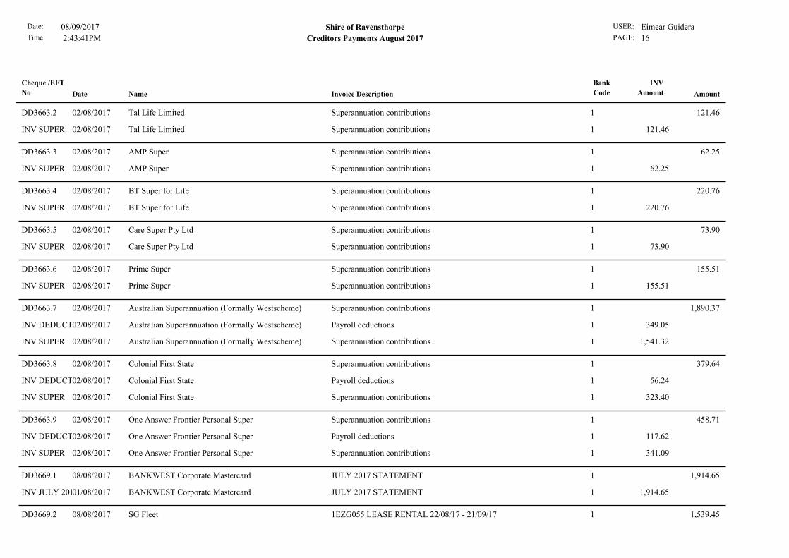
1Superannuation contributionsTal Life Limited02/08/2017 121.46DD3663.2
1Superannuation contributionsTal Life Limited02/08/2017INV SUPER 121.46
1Superannuation contributionsAMP Super02/08/2017 62.25DD3663.3
1Superannuation contributionsAMP Super02/08/2017INV SUPER 62.25
1Superannuation contributionsBT Super for Life02/08/2017 220.76DD3663.4
1Superannuation contributionsBT Super for Life02/08/2017INV SUPER 220.76
1Superannuation contributionsCare Super Pty Ltd02/08/2017 73.90DD3663.5
1Superannuation contributionsCare Super Pty Ltd02/08/2017INV SUPER 73.90
1Superannuation contributionsPrime Super02/08/2017 155.51DD3663.6
1Superannuation contributionsPrime Super02/08/2017INV SUPER 155.51
1Superannuation contributionsAustralian Superannuation (Formally Westscheme)02/08/2017 1,890.37DD3663.7
1Payroll deductionsAustralian Superannuation (Formally Westscheme)02/08/2017INV DEDUCTION 349.05
1Superannuation contributionsAustralian Superannuation (Formally Westscheme)02/08/2017INV SUPER 1,541.32
1Superannuation contributionsColonial First State02/08/2017 379.64DD3663.8
1Payroll deductionsColonial First State02/08/2017INV DEDUCTION 56.24
1Superannuation contributionsColonial First State02/08/2017INV SUPER 323.40
1Superannuation contributionsOne Answer Frontier Personal Super02/08/2017 458.71DD3663.9
1Payroll deductionsOne Answer Frontier Personal Super02/08/2017INV DEDUCTION 117.62
1Superannuation contributionsOne Answer Frontier Personal Super02/08/2017INV SUPER 341.09
1JULY 2017 STATEMENTBANKWEST Corporate Mastercard08/08/2017 1,914.65DD3669.1
1JULY 2017 STATEMENTBANKWEST Corporate Mastercard01/08/2017INV JULY 2017 1,914.65
11EZG055 LEASE RENTAL 22/08/17 - 21/09/17SG Fleet08/08/2017 1,539.45DD3669.2

Date:
Time: 2:43:41PM
Shire of Ravensthorpe USER: Eimear GuideraPAGE: 17
08/09/2017
Creditors Payments August 2017
Cheque /EFT
No Date Name Invoice Description
Bank
Code Amount
INV
Amount
11EZG055 LEASE RENTAL 22/08/17 - 21/09/17SG Fleet31/07/2017INV AUSG00078901 1,539.45
1Payroll deductionsWA Local Government Super Plan16/08/2017 8,822.98DD3678.1
1Superannuation contributionsWA Local Government Super Plan16/08/2017INV SUPER 8,009.42
1Payroll deductionsWA Local Government Super Plan16/08/2017INV DEDUCTION 178.40
1Payroll deductionsWA Local Government Super Plan16/08/2017INV DEDUCTION 420.74
1Payroll deductionsWA Local Government Super Plan16/08/2017INV DEDUCTION 41.42
1Payroll deductionsWA Local Government Super Plan16/08/2017INV DEDUCTION 47.05
1Payroll deductionsWA Local Government Super Plan16/08/2017INV DEDUCTION 5.18
1Payroll deductionsWA Local Government Super Plan16/08/2017INV DEDUCTION 120.77
1Payroll deductions100F Lifetrack Personal Super16/08/2017 432.31DD3678.2
1Superannuation contributions100F Lifetrack Personal Super16/08/2017INV SUPER 291.56
1Payroll deductions100F Lifetrack Personal Super16/08/2017INV DEDUCTION 140.75
1Superannuation contributionsTal Life Limited16/08/2017 120.27DD3678.3
1Superannuation contributionsTal Life Limited16/08/2017INV SUPER 120.27
1Superannuation contributionsAMP Super16/08/2017 47.89DD3678.4
1Superannuation contributionsAMP Super16/08/2017INV SUPER 47.89
1Superannuation contributionsBT Super for Life16/08/2017 220.76DD3678.5
1Superannuation contributionsBT Super for Life16/08/2017INV SUPER 220.76
1Superannuation contributionsCare Super Pty Ltd16/08/2017 91.05DD3678.6
1Superannuation contributionsCare Super Pty Ltd16/08/2017INV SUPER 91.05
1Superannuation contributionsPrime Super16/08/2017 76.84DD3678.7
1Superannuation contributionsPrime Super16/08/2017INV SUPER 76.84

Date:
Time: 2:43:41PM
Shire of Ravensthorpe USER: Eimear GuideraPAGE: 18
08/09/2017
Creditors Payments August 2017
Cheque /EFT
No Date Name Invoice Description
Bank
Code Amount
INV
Amount
1Superannuation contributionsAustralian Superannuation (Formally Westscheme)16/08/2017 1,133.42DD3678.8
1Payroll deductionsAustralian Superannuation (Formally Westscheme)16/08/2017INV DEDUCTION 152.36
1Superannuation contributionsAustralian Superannuation (Formally Westscheme)16/08/2017INV SUPER 981.06
1Superannuation contributionsColonial First State16/08/2017 379.64DD3678.9
1Payroll deductionsColonial First State16/08/2017INV DEDUCTION 56.24
1Superannuation contributionsColonial First State16/08/2017INV SUPER 323.40
1Payroll deductionsWA Local Government Super Plan30/08/2017 9,744.63DD3686.1
1Superannuation contributionsWA Local Government Super Plan30/08/2017INV SUPER 8,924.89
1Payroll deductionsWA Local Government Super Plan30/08/2017INV DEDUCTION 178.40
1Payroll deductionsWA Local Government Super Plan30/08/2017INV DEDUCTION 425.19
1Payroll deductionsWA Local Government Super Plan30/08/2017INV DEDUCTION 43.37
1Payroll deductionsWA Local Government Super Plan30/08/2017INV DEDUCTION 47.05
1Payroll deductionsWA Local Government Super Plan30/08/2017INV DEDUCTION 4.96
1Payroll deductionsWA Local Government Super Plan30/08/2017INV DEDUCTION 120.77
1Payroll deductions100F Lifetrack Personal Super30/08/2017 114.17DD3686.2
1Superannuation contributions100F Lifetrack Personal Super30/08/2017INV SUPER 77.00
1Payroll deductions100F Lifetrack Personal Super30/08/2017INV DEDUCTION 37.17
1Superannuation contributionsTal Life Limited30/08/2017 134.56DD3686.3
1Superannuation contributionsTal Life Limited30/08/2017INV SUPER 134.56
1Superannuation contributionsAMP Super30/08/2017 52.68DD3686.4
1Superannuation contributionsAMP Super30/08/2017INV SUPER 52.68
1Superannuation contributionsSuperWrap Personal Super Plan30/08/2017 72.22DD3686.5
1Superannuation contributionsSuperWrap Personal Super Plan30/08/2017INV SUPER 72.22

Date:
Time: 2:43:41PM
Shire of Ravensthorpe USER: Eimear GuideraPAGE: 19
08/09/2017
Creditors Payments August 2017
Cheque /EFT
No Date Name Invoice Description
Bank
Code Amount
INV
Amount
1Superannuation contributionsBT Super for Life30/08/2017 198.69DD3686.6
1Superannuation contributionsBT Super for Life30/08/2017INV SUPER 198.69
1Superannuation contributionsCare Super Pty Ltd30/08/2017 81.40DD3686.7
1Superannuation contributionsCare Super Pty Ltd30/08/2017INV SUPER 81.40
1Superannuation contributionsPrime Super30/08/2017 78.37DD3686.8
1Superannuation contributionsPrime Super30/08/2017INV SUPER 78.37
1Payroll deductionsAustralian Superannuation (Formally Westscheme)30/08/2017 842.68DD3686.9
1Superannuation contributionsAustralian Superannuation (Formally Westscheme)30/08/2017INV SUPER 764.40
1Payroll deductionsAustralian Superannuation (Formally Westscheme)30/08/2017INV DEDUCTION 78.28
1Superannuation contributions100F Lifetrack Personal Super02/08/2017 514.50DD3663.10
1Payroll deductions100F Lifetrack Personal Super02/08/2017INV DEDUCTION 167.51
1Superannuation contributions100F Lifetrack Personal Super02/08/2017INV SUPER 346.99
1Superannuation contributionsC-Bus Super02/08/2017 213.79DD3663.11
1Superannuation contributionsC-Bus Super02/08/2017INV SUPER 213.79
1Superannuation contributionsBT Super For Life02/08/2017 94.94DD3663.12
1Superannuation contributionsBT Super For Life02/08/2017INV SUPER 94.94
1Superannuation contributionsMLC Superannuation02/08/2017 98.01DD3663.13
1Superannuation contributionsMLC Superannuation02/08/2017INV SUPER 98.01
1Superannuation contributionsConcept One (The Industry Superannuation Fund)02/08/2017 46.74DD3663.14
1Superannuation contributionsConcept One (The Industry Superannuation Fund)02/08/2017INV SUPER 46.74
1Superannuation contributionsOne Answer Frontier Personal Super16/08/2017 458.71DD3678.10

Date:
Time: 2:43:41PM
Shire of Ravensthorpe USER: Eimear GuideraPAGE: 20
08/09/2017
Creditors Payments August 2017
Cheque /EFT
No Date Name Invoice Description
Bank
Code Amount
INV
Amount
1Payroll deductionsOne Answer Frontier Personal Super16/08/2017INV DEDUCTION 117.62
1Superannuation contributionsOne Answer Frontier Personal Super16/08/2017INV SUPER 341.09
1Superannuation contributionsC-Bus Super16/08/2017 213.80DD3678.11
1Superannuation contributionsC-Bus Super16/08/2017INV SUPER 213.80
1Superannuation contributionsBT Super For Life16/08/2017 94.94DD3678.12
1Superannuation contributionsBT Super For Life16/08/2017INV SUPER 94.94
1Superannuation contributionsMLC Superannuation16/08/2017 98.01DD3678.13
1Superannuation contributionsMLC Superannuation16/08/2017INV SUPER 98.01
1Superannuation contributionsConcept One (The Industry Superannuation Fund)16/08/2017 46.74DD3678.14
1Superannuation contributionsConcept One (The Industry Superannuation Fund)16/08/2017INV SUPER 46.74
1Superannuation contributionsHostplus Superannuation16/08/2017 55.39DD3678.15
1Superannuation contributionsHostplus Superannuation16/08/2017INV SUPER 55.39
1Superannuation contributionsColonial First State30/08/2017 379.64DD3686.10
1Payroll deductionsColonial First State30/08/2017INV DEDUCTION 56.24
1Superannuation contributionsColonial First State30/08/2017INV SUPER 323.40
1Superannuation contributionsOne Answer Frontier Personal Super30/08/2017 458.71DD3686.11
1Payroll deductionsOne Answer Frontier Personal Super30/08/2017INV DEDUCTION 117.62
1Superannuation contributionsOne Answer Frontier Personal Super30/08/2017INV SUPER 341.09
1Superannuation contributionsC-Bus Super30/08/2017 213.80DD3686.12
1Superannuation contributionsC-Bus Super30/08/2017INV SUPER 213.80
1Superannuation contributionsBT Super For Life30/08/2017 94.94DD3686.13
1Superannuation contributionsBT Super For Life30/08/2017INV SUPER 94.94

Date:
Time: 2:43:41PM
Shire of Ravensthorpe USER: Eimear GuideraPAGE: 21
08/09/2017
Creditors Payments August 2017
Cheque /EFT
No Date Name Invoice Description
Bank
Code Amount
INV
Amount
1Superannuation contributionsMLC Superannuation30/08/2017 98.01DD3686.14
1Superannuation contributionsMLC Superannuation30/08/2017INV SUPER 98.01
1Superannuation contributionsConcept One (The Industry Superannuation Fund)30/08/2017 46.74DD3686.15
1Superannuation contributionsConcept One (The Industry Superannuation Fund)30/08/2017INV SUPER 46.74
1Superannuation contributionsHostplus Superannuation30/08/2017 56.60DD3686.16
1Superannuation contributionsHostplus Superannuation30/08/2017INV SUPER 56.60
1PAYROLL PROCESSING 02.08.17SHIRE OF RAVENSTHORPE02/08/2017 94,006.1502082017
1PAYROLL PROCESSING 16.08.17SHIRE OF RAVENSTHORPE16/08/2017 87,049.4416082017
1PAYROLL PROCESSING 30.08.17SHIRE OF RAVENSTHORPE30/08/2017 85,203.4030082017
TOTAL
1 Municipal Bank Account 737,670.06
2 Trust Bank Account 39,358.05
TOTAL 777,028.11
REPORT TOTALS
Bank NameBank Code
02 August 2017 - 01 September 2017
Date Payment to Description Amount GST
4/08/2017 SFS PCEC, Perth Lunch LG Week - CEO, President & Deputy President 34.00 3.09
8/08/2017 Adina Apartment Hotels, Perth Accomodation & meals LG Week - President 1636.40 148.76
8/08/2017 Adina Apartment Hotels, Perth Accomodation & meals LG Week - Deputy President 1742.66 158.42
8/08/2017 Adina Apartment Hotels, Perth Accomodation & meals LG Week - CEO 2310.90 210.08
8/08/2017 Total BS & Co., Perth Dinner LG Week 250.29 22.75
16/08/2017 EHA (SA) Inc Newstead Food safety assessment pads 210.30 19.12
21/08/2017 Ravensthorpe Hotel Council Dinner 298.00 27.09
21/08/2017 Australia Post, Ravensthorpe Police clarance CEO 49.90 4.54
28/08/2017 Rydges, Kalgoorlie Accomodation & meals GVROC - CEO & President 488.90 44.45
29/08/2017 Hopetoun IGA Supplies for Culham Inlet opening BBQ 108.04 9.82
29/08/2017 Shipwreck Gourmet Bakery, Hopetoun Bread rolls for Culham Inlet opening BBQ 91.80 8.35
1/09/2017 Bunnings, Esperance Water filter for 18 Carlisle Street 84.90 7.72
1/09/2017 Bankwest Reward Fee - Corproate 39.00 3.55
Total Purchases for I. Fitzgerald 7,345.09 667.74
Date Payment to Description Amount GST
8/08/2017 VistaPrint.com FCTA car magnets 764.95 69.54
9/08/2017 Big W Online Childcare change pad for Cubhouse 52.90 4.81
15/08/2017 Australia Post National Police Clearance - Jennifer Goodbourn 52.60 4.78
16/08/2017 Australia Post National Police Clearance - Jane Francis 52.60 4.78
16/08/2017 Australia Post National Police Clearance - Victoria 52.60 4.78
17/08/2017 L&W International, Padstow Double sided outdoor Aframe - FCTA 1690.00 153.64
21/08/2017 Norsat WA Pty Ltd, Kewdale 12V PSU decoder power supply 66.00 6.00
21/08/2017 Ausure Insurance Insurance policy for Ravensthorpe Youth Clun Inc 906.18 82.38
31/08/2017 Bankwest Reward Fee - Corporate 39.00 3.55
3676.83 334.26
Date Payment to Description Amount GST
5/08/2017 Landmark, Ravensthorpe Vehicle parts 193.92 17.63
31/08/2017 Bankwest Reward Fee - Corporate 39.00 3.55
232.92 21.17
Date Payment to Description Amount GST
11/08/2017 Best Western, Ascot Accomodation for Stacey Jaskiewicz Training 727.78 66.16
11/08/2017 Best Western, Ascot Meals for Stacey Jaskiewicz Training 63.18 5.74
18/08/2017 Kalgoorlie Overland Motel Accomodation and brekfast for Simon Russell Training 156.00 14.18
26/08/2017 Best Western, Ascot Accomodation for Stacey Jaskiewicz Training 1040.42 94.58
31/08/2017 Bankwest Reward Fee - Corporate 39.00 3.55
2026.38 184.22
Date Payment to Description Amount GST
Total Fees and Charges 13,281.22$ 1,207.38$
Business Credit Card - Ian Fitzgerald Bankwest
Business Credit Card - Jennifer Goodbourn Bankwest
Business Credit Card - Ashley Peczka Bankwest
Business Credit Card - Miscellaneous Fees and Charges Bankwest
Business Credit Card - Darryn Watkins Bankwest
SHIRE OF RAVENSTHORPE
FOR THE PERIOD 1 JULY 2017 TO 31 AUGUST 2017
TABLE OF CONTENTS
Page
Statement of Financial Activity 1
Report on Significant Variances 2
Notes to and Forming Part of the Statement
1 Acquisition of Assets 3 to 4
2 Disposal of Assets 5
3 Information on Borrowings 6
4 Reserves 7 to 9
5 Net Current Assets 10
6 Rating Information 11
7 Trust Funds 14
8 Operating Statement 15 to 16
9 Statement of Financial Position 17
10 Financial Ratios 18
MONTHLY STATEMENT OF FINANCIAL ACTIVITY

0
Income and Expenditure Graphs to 31 August 2017
0
5,000
10,000
15,000
20,000
25,000
Jul Aug Sep Oct Nov Dec Jan Feb Mar Apr May Jun
Am
ou
nt
$ (
'00
0s)
Operating Expenditure
YTDActual
YTDBudget
0
2,000
4,000
6,000
8,000
10,000
12,000
14,000
16,000
18,000
20,000
Jul Aug Sep Oct Nov Dec Jan Feb Mar Apr May Jun
Am
ou
nt
$ (
'00
0s)
Operating Income
YTDActual
YTDBudget
0
1,000
2,000
3,000
4,000
5,000
6,000
7,000
Jul Aug Sep Oct Nov Dec Jan Feb Mar Apr May Jun
Am
ou
nt
$ (
'00
0s)
Capital Expenditure
YTDActual
YTDBudget
0
200
400
600
800
1,000
1,200
1,400
1,600
1,800
2,000
Jul Aug Sep Oct Nov Dec Jan Feb Mar Apr May Jun
Am
ou
nt
$ (
'00
0s)
Capital Income
YTDActual
YTDBudget
Page 1

Other Graphs to 31 August 2017
-
50.0
100.0
150.0
200.0
250.0
300.0
350.0
Current > 30 Days > 60 Days > 90 Days
Am
ou
nt
$ (
'00
0's
)
Days
Sundry Debtors Amount O/S
-20.00%
0.00%
20.00%
40.00%
60.00%
80.00%
100.00%
120.00%
Jul Aug Sep Oct Nov Dec Jan Feb Mar Apr May Jun
Am
ou
nt
%
Rates % Collected
2017/18Actual
2016/17Actual
0
200
400
600
800
1,000
1,200
1,400
1,600
1,800
Am
ou
nt
$ (
'00
0's
)
Capital Class
Capital Expenditure
FullYearBudget
YTDBudget
YTDActual
Page 2

Variances
NOTE 2017/18 2017/18 August August Variances Actual
Adopted Revised 2017 2017 Actuals to Budget to
Operating Budget Budget Y-T-D Budget Actual Budget Y-T-D
$ $ $ $ $ %
Revenues/Sources
Governance 3,825 3,825 0 0 0 0.00%
General Purpose Funding 1,103,693 1,103,693 252,186 271,392 19,206 7.62%
Law, Order, Public Safety 196,149 196,149 21,246 3,742 (17,504) (82.39%) ▼
Health 3,000 3,000 499 2,750 2,251 451.10%
Education and Welfare 192,361 192,361 32,046 0 (32,046) (100.00%) ▼
Housing 10,400 10,400 1,402 1,600 198 14.12%
Community Amenities 833,127 833,127 308,839 430,589 121,750 39.42% ▲
Recreation and Culture 298,500 298,500 4,314 51,024 46,710 1082.75% ▲
Transport 12,010,248 12,010,248 1,945,848 925,646 (1,020,202) (52.43%) ▼
Economic Services 98,500 98,500 5,080 3,669 (1,411) (27.78%)
Other Property and Services 155,000 155,000 24,548 6,746 (17,802) (72.52%) ▼
14,904,803 14,904,803 2,596,008 1,697,158 (898,850) (34.62%)
(Expenses)/(Applications)
Governance (586,688) (586,688) (94,061) (101,416) (7,355) (7.82%)
General Purpose Funding (157,749) (157,749) (30,870) (19,126) 11,744 38.04% ▼
Law, Order, Public Safety (583,620) (583,620) (106,176) (98,333) 7,843 7.39%
Health (260,635) (260,635) (38,276) (45,379) (7,103) (18.56%)
Education and Welfare (353,617) (353,617) (58,577) (54,744) 3,833 6.54%
Housing (262,228) (262,228) (32,673) (9,824) 22,849 69.93% ▼
Community Amenities (1,290,994) (1,290,994) (180,074) (127,182) 52,892 29.37% ▼
Recreation & Culture (1,650,851) (1,650,851) (256,953) (141,288) 115,665 45.01% ▼
Transport (13,983,149) (13,983,149) (1,954,849) (915,793) 1,039,056 53.15% ▼
Economic Services (314,435) (314,435) (34,508) (38,532) (4,024) (11.66%)
Other Property and Services (294,294) (294,294) (109,226) 98,370 207,596 190.06% ▼
(19,738,260) (19,738,261) (2,896,243) (1,453,247) 1,442,996 (49.82%)
Net Operating Result Excluding Rates (4,833,457) (4,833,458) (300,235) 243,911 544,146 (181.24%)
Adjustments for Non-Cash
(Revenue) and Expenditure
(Profit)/Loss on Asset Disposals 2 111,405 111,405 1,408 0 (1,408) 100.00%
Movement in Deferred Pensioner Rates/ESL 0 0 0 0 0 0.00%
Movement in Employee Benefit Provisions 0 0 0 0 0 0.00%
Rounding 0 0 0 0 0 0.00%
Depreciation on Assets 3,352,401 3,352,401 567,856 0 (567,856) 100.00% ▼
Capital Revenue and (Expenditure)
Purchase Land Held for Resale 1 0 0 0 0 0 0.00%
Purchase of Land and Buildings 1 (71,200) (71,200) (6,864) 0 6,864 100.00%
Purchase of Furniture & Equipment 1 (60,000) (60,000) (832) (4,760) (3,928) (472.12%)
Purchase of Plant & Equipment 1 (1,292,800) (1,292,800) (215,456) (44) 215,412 99.98% ▼
Purchase of WIP - PP & E 1 0 0 0 0 0 0.00%
Purchase of Infrastructure Assets - Roads 1 (1,508,050) (1,508,050) (192,834) (54,717) 138,117 71.62% ▼
Purchase of Infrastructure Assets - Footpaths 1 (29,810) (29,810) (4,962) 0 4,962 100.00%
Purchase of Infrastructure Assets - Drainage 1 0 0 0 0 0 0.00%
Purchase of Infrastructure Assets - Parks & Ovals 1 (431,690) (431,690) (71,942) 0 71,942 100.00% ▼
Purchase of Infrastructure Assets - Airports 1 (533,550) (533,550) (88,918) 0 88,918 100.00% ▼
Purchase of Infrastructure Assets - Other 1 (399,069) (399,069) (28) (38,763) (38,735) (138339.29%) ▲
Purchase of WIP - INFRA 1 0 0 0 0 0 0.00%
Proceeds from Disposal of Assets 2 233,992 233,992 4,090 0 (4,090) (100.00%)
Repayment of Debentures 3 (193,909) (193,909) (66,557) (65,952) 605 0.91%
Proceeds from New Debentures 3 0 0 0 0 0 0.00%
Advances to Community Groups 0 0 0 0 0 0.00%
Self-Supporting Loan Principal Income 0 0 0 0 0 0.00%
Transfers to Restricted Assets (Reserves) 4 (1,605,000) (1,605,000) (10,164) (7,783) 2,381 23.43%
Transfers from Restricted Asset (Reserves) 4 1,541,275 1,541,275 56,878 0 (56,878) (100.00%) ▼
ADD Net Current Assets July 1 B/Fwd 5 1,713,985 1,713,985 1,713,985 1,720,825 6,840 (0.40%)
LESS Net Current Assets Year to Date 5 (523) (524) 1,386,779 5,792,977 4,406,198 (317.73%)
Amount Raised from Rates (4,004,954) (4,004,954) (1,354) (4,000,260) (3,998,906) 295340.18%
This statement is to be read in conjunction with the accompanying notes.
Material Variances Symbol
Above Budget Expectations Greater than 10% and $10,000 ▲
Below Budget Expectations Less than 10% and $10,000 ▼
SHIRE OF RAVENSTHORPE
STATEMENT OF FINANCIAL ACTIVITY
FOR THE PERIOD 1 JULY 2017 TO 31 AUGUST 2017
Page 3

SHIRE OF RAVENSTHORPE
FOR THE PERIOD 1 JULY 2017 TO 31 AUGUST 2017
Report on Significant variances Greater than 10% and $10,000
Purpose
The Materiality variances adopted by Council are:
Actual Variance to YTD Budget up to 5%: Don’t Report
Actual Variance exceeding 10% of YTD Budget Use Management Discretion
Actual Variance exceeding 10% of YTD Budget and a value greater than $10,000: Must Report
REPORTABLE OPERATING REVENUE VARIATIONS
General Purpose Funding -
Law, Order, Public Safety - revenue under YTD budget
Health - revenue over YTD budget
Education and Welfare - Revenue under YTD budget
Community Amenities - Revenue over YTD budget
Recreation and Culture - Revenue over YTD budget
Transport - Revenue under YTD Budget
Economic Services -
Other Property and Services - revenue under YTD budget
REPORTABLE OPERATING EXPENSE VARIATIONS
Governance -
General Purpose Funding - Expenditure under YTD budget
Law, Order, Public Safety -
Health - Expenditure over YTD budget
Education and Welfare -
Housing - Expenditure under YTD budget
Communtiy Amenities - Expenditure under YTD budget
Recreation & Culture - Expenditure under YTDbudget
Transport - Expenditure under YTD budget
Economic Services - Expenditure over YTD budget
Other Property and Services - Expenditure under YTD budget
REPORTABLE NON-CASH VARIATIONS
(Profit)/Loss on Asset Disposals -
Depreciation on Assets - Under YTD budget
REPORTABLE CAPITAL EXPENSE VARIATIONS
Purchase of Land & Buildings -
Purchase of Furniture & Equipment -
Purchase of Plant & Equipment - Expenditure under YTD budget
Purchase of Infrastructure Assets Roads - Expenditure under YTD budget
Purchase of Infrastructure Parks & Assets - Expenditure under YTD budget
Purchase of Infrastructure Airports - Expenditure under YTD budget
Purchases of Infrastructure Other - Expenditure over YTD budget
REPORTABLE CAPITAL INCOME VARIATIONS
Proceeds from Disposal of Assets -
Repayment of Debentures -
Timing of plant purchases
Timing of Road projects
Purchsase of dome for compactor at Landfill site
Timing of projects
Timing of projects
Rubbish and Sewerage rates raised in August - Budgeted for September
Fruit Fly Traps purchased earlier than budgeted
Timing of projects
Timing of maintenance works
Timing of projects
Rate debt collection cost less as rates only just issued.
Recoup of plant cost rates need to be amended
Timing of flood damage works and recoups - commencing later than anticipated
Fitzgerald Biosphere Payments made already
The purpose of the Monthly Variance Report is to highlight circumstances where there is a major variance from the YTD Monthly Budget
and YTD Actual figures. These variances can occur because of a change in timing of the activity, circumstances change (e.g. a grants
were budgeted for but was not received) or changes to the original budget projections. The Report is designed to highlight these issues
and explain the reason for the variance.
Munglinup Playground funds received.
Timing of flood damage works and recoups - commencing later than anticipated
Timing of dieselt fuel rebate -1/4ly
Timing of Child care expenses recoup
Timing of CESO Recoup
Food trading licences issued
Deptreciation to be calculated once 16/17 revaluaitons completed
Page 4

2017/18 2017/18 2017/18 August
Adopted Revised YTD 2017
1. ACQUISITION OF ASSETS Budget Budget Budget Actual
$ $ $ $
The following assets have been acquired during
the period under review:
By Program
Health
Doctors & Other Health
5,000 5,000 832 0.00
55,000 55,000 9,166 0.00
5,000 5,000 832 0.00
Education & Welfare
Child Care Centres
15,000 15,000 2,500 0.00
Community Amenities
Sanitation - household Refuse\
75,000 75,000 2 0.00
75,000 75,000 2 0.00
249,069 249,069 24 38,762.81
Sewerage
Recreation and Culture
Public Halls & Civic Centres
50,000 50,000 0 4,760.00
Other Recreation & Sport
30,000 30,000 0 0.00
0 0 0 0.00
174,190 174,190 29,028 0.00
7,000 7,000 1,166 0.00
50,500 50,500 8,416 0.00
200,000 200,000 33,332 0.00
Libraries
14,200 14,200 2,366 0.00
7,000 7,000 1,166 0.00
Transport
Construction - Roads, Bridges, Depots
150,000 150,000 24,998 0.00
49,220 49,220 0 0.00
45,000 45,000 7,496 0.00
23,164 23,164 3,858 0.00
50,310 50,310 8,378 0.00
25,000 25,000 4,164 0.00
40,000 40,000 6,768 0.00
40,000 40,000 6,768 90.90
142,256 142,256 0 0.00
70,848 70,848 0 0.00
32,545 32,545 0 30,586.42
Rangeview Park Upgrade
Hopetoun Sports Ground Access
Resurface Courts - Hopetoun
Ravensthorpe Cricket Pitch
Munglinup Community Playground
Ravesnthorpe Tennis Courts
Roads Construction Council
Roads Mrwa V Of G Constr
Jerdacuttup Road X Bedford Hbr Road
Ravensthorpe Crc - Kitchen Improvements
Surgery Upgrade Ravensthorpe
Gravel Pit Development
New Inverter Air-Cons
Veal Street - Carpark Expansion
Gravel Pit Reinstatement
Ethel Daw Drive
Jerdacuttup Road - Tamrine Road
Phillips River Rd Canoe Trail
Streetscape Morgan Street Stage 2
Floodway Sealing Repairs
SHIRE OF RAVENSTHORPE
NOTES TO AND FORMING PART OF THE STATEMENT OF FINANCIAL ACTIVITY
FOR THE PERIOD 1 JULY 2017 TO 31 AUGUST 2017
Hamersley Drive X Hopetoun Road
Roads Mrwa V Of G Constr
Ravensthorpe Streetscape
New Furniture - Ravensthorpe Surgery
Munglinup Transfer Station
Hopetoun Transfer Station
Ravensthorpe Regional Landfill
Hopetoun Community Centre Fit Out
Little Barrens- Air-Con
Toyota Hilux - Doctor
Page 5
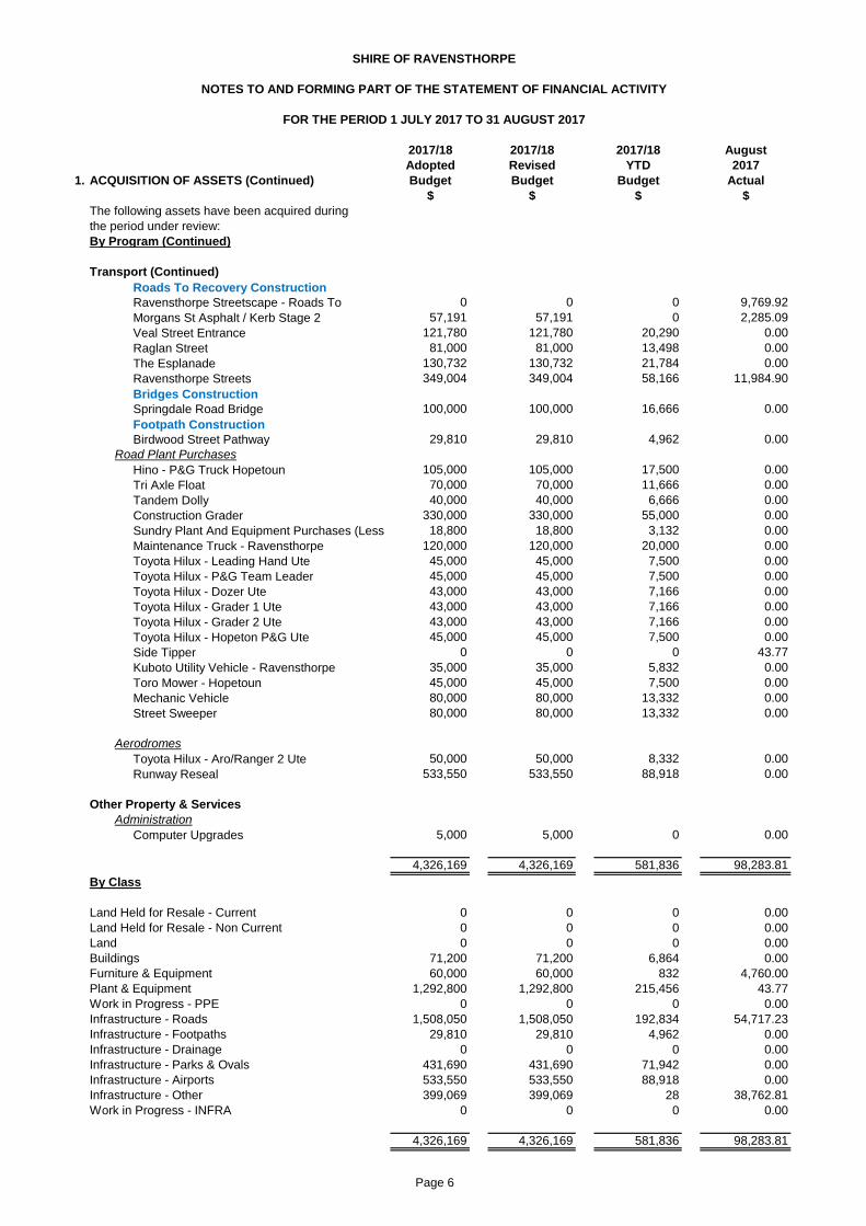
2017/18 2017/18 2017/18 August
Adopted Revised YTD 2017
1. ACQUISITION OF ASSETS (Continued) Budget Budget Budget Actual
$ $ $ $
The following assets have been acquired during
the period under review:
By Program (Continued)
Transport (Continued)
0 0 0 9,769.92
57,191 57,191 0 2,285.09
121,780 121,780 20,290 0.00
81,000 81,000 13,498 0.00
130,732 130,732 21,784 0.00
349,004 349,004 58,166 11,984.90
100,000 100,000 16,666 0.00
29,810 29,810 4,962 0.00
Road Plant Purchases
105,000 105,000 17,500 0.00
70,000 70,000 11,666 0.00
40,000 40,000 6,666 0.00
330,000 330,000 55,000 0.00
18,800 18,800 3,132 0.00
120,000 120,000 20,000 0.00
45,000 45,000 7,500 0.00
45,000 45,000 7,500 0.00
43,000 43,000 7,166 0.00
43,000 43,000 7,166 0.00
43,000 43,000 7,166 0.00
45,000 45,000 7,500 0.00
0 0 0 43.77
35,000 35,000 5,832 0.00
45,000 45,000 7,500 0.00
80,000 80,000 13,332 0.00
80,000 80,000 13,332 0.00
Aerodromes
50,000 50,000 8,332 0.00
533,550 533,550 88,918 0.00
Other Property & Services
Administration
5,000 5,000 0 0.00
4,326,169 4,326,169 581,836 98,283.81
By Class
Land Held for Resale - Current 0 0 0 0.00
Land Held for Resale - Non Current 0 0 0 0.00
Land 0 0 0 0.00
Buildings 71,200 71,200 6,864 0.00
Furniture & Equipment 60,000 60,000 832 4,760.00
Plant & Equipment 1,292,800 1,292,800 215,456 43.77
Work in Progress - PPE 0 0 0 0.00
Infrastructure - Roads 1,508,050 1,508,050 192,834 54,717.23
Infrastructure - Footpaths 29,810 29,810 4,962 0.00
Infrastructure - Drainage 0 0 0 0.00
Infrastructure - Parks & Ovals 431,690 431,690 71,942 0.00
Infrastructure - Airports 533,550 533,550 88,918 0.00
Infrastructure - Other 399,069 399,069 28 38,762.81
Work in Progress - INFRA 0 0 0 0.00
4,326,169 4,326,169 581,836 98,283.81
The Esplanade
Ravensthorpe Streets
Roads To Recovery Construction
Runway Reseal
Mechanic Vehicle
Street Sweeper
Toyota Hilux - Grader 1 Ute
Toyota Hilux - Grader 2 Ute
Toyota Hilux - Hopeton P&G Ute
Birdwood Street Pathway
Raglan Street
Tri Axle Float
Tandem Dolly
Hino - P&G Truck Hopetoun
Footpath Construction
Ravensthorpe Streetscape - Roads To
Veal Street Entrance
Morgans St Asphalt / Kerb Stage 2
SHIRE OF RAVENSTHORPE
NOTES TO AND FORMING PART OF THE STATEMENT OF FINANCIAL ACTIVITY
FOR THE PERIOD 1 JULY 2017 TO 31 AUGUST 2017
Bridges Construction
Springdale Road Bridge
Construction Grader
Sundry Plant And Equipment Purchases (Less
Computer Upgrades
Maintenance Truck - Ravensthorpe
Toyota Hilux - Dozer Ute
Toyota Hilux - P&G Team Leader
Toyota Hilux - Aro/Ranger 2 Ute
Toyota Hilux - Leading Hand Ute
Side Tipper
Kuboto Utility Vehicle - Ravensthorpe
Toro Mower - Hopetoun
Page 6

2. DISPOSALS OF ASSETS
The following assets have been disposed of during the period under review:
By Program August August August
2017/18 2017 2017/18 2017 2017/18 2017
Budget Actual Budget Actual Budget Actual
$ $ $ $ $ $
Health
Toyota Kluger GXL - Doctor 33,001 0.00 24,545 0.00 (8,456) 0.00
Transport
John Deere 670 GP Construction Grader 105,284 0.00 52,000 0.00 (53,284) 0.00
Mitsubishi Triton 2014 15,095 0.00 8,181 0.00 (6,914) 0.00
RA3359 - Hilux - 2012 Triton 23,393 0.00 15,545 0.00 (7,848) 0.00
Ford Ranger 21,619 0.00 20,090 0.00 (1,529) 0.00
Isuzu Maintenance Truck 29,038 0.00 18,181 0.00 (10,857) 0.00
2013 Triton - Grader 1 14,828 0.00 7,272 0.00 (7,556) 0.00
2013 Triton - Grader 2 14,828 0.00 6,363 0.00 (8,465) 0.00
2013 Triton - Dozer 13,898 0.00 8,181 0.00 (5,717) 0.00
2010 Hino - P&G Truck Hopetoun 27,498 0.00 16,363 0.00 (11,135) 0.00
2005 Tri Axle Float 6,493 0.00 36,363 0.00 29,870 0.00
2005 Tandem Dolly 13,527 0.00 3,636 0.00 (9,891) 0.00
Toyota Hilux Ute - Airport Manger 26,896 0.00 17,272 0.00 (9,624) 0.00
345,397 0.00 233,992 0.00 (111,405) 0.00
By Class of Asset
August August August
2017/18 2017 2017/18 2017 2017/18 2017
Budget Actual Budget Actual Budget Actual
$ $ $ $ $ $
Plant & Equipment
Toyota Kluger GXL - Doctor 33,001 0.00 24,545 0.00 (8,456) 0.00
John Deere 670 GP Construction Grader 105,284 0.00 52,000 0.00 (53,284) 0.00
Mitsubishi Triton 2014 15,095 0.00 8,181 0.00 (6,914) 0.00
RA3359 - Hilux - 2012 Triton 23,393 0.00 15,545 0.00 (7,848) 0.00
Ford Ranger 21,619 0.00 20,090 0.00 (1,529) 0.00
Isuzu Maintenance Truck 29,038 0.00 18,181 0.00 (10,857) 0.00
2013 Triton - Grader 1 14,828 0.00 7,272 0.00 (7,556) 0.00
2013 Triton - Grader 2 14,828 0.00 6,363 0.00 (8,465) 0.00
2013 Triton - Dozer 13,898 0.00 8,181 0.00 (5,717) 0.00
2010 Hino - P&G Truck Hopetoun 27,498 0.00 16,363 0.00 (11,135) 0.00
2005 Tri Axle Float 6,493 0.00 36,363 0.00 29,870 0.00
2005 Tandem Dolly 13,527 0.00 3,636 0.00 (9,891) 0.00
Toyota Hilux Ute - Airport Manger 26,896 0.00 17,272 0.00 (9,624) 0.00
345,397 0.00 233,992 0.00 (111,405) 0.00
2017/18 August
Adopted 2017
Budget Actual
Summary $ $
Profit on Asset Disposals 29,870 0.00
Loss on Asset Disposals (141,275) 0.00
(111,405) 0.00
SHIRE OF RAVENSTHORPE
NOTES TO AND FORMING PART OF THE STATEMENT OF FINANCIAL ACTIVITY
FOR THE PERIOD 1 JULY 2017 TO 31 AUGUST 2017
Written Down Value Sale Proceeds
Sale ProceedsWritten Down Value
Profit(Loss)
Profit(Loss)
Page 7

SHIRE OF RAVENSTHORPE
NOTES TO AND FORMING PART OF THE STATEMENT OF FINANCIAL ACTIVITY
FOR THE PERIOD 1 JULY 2017 TO 31 AUGUST 2017
3. INFORMATION ON BORROWINGS
(a) Debenture Repayments
Principal Principal Principal Interest
1-Jul-17 Repayments Outstanding Repayments
2017/18 2017/18 2017/18 2017/18 2017/18 2017/18 2017/18 2017/18
Particulars Budget Actual Budget Actual Budget Actual Budget Actual
$ $ $ $ $ $ $ $
Housing
Loan 145 Satff Housing 291,827 0 0 32,957 16,362 258,870 275,465 9,930 830
Loan 147 Other Housing 270,108 0 0 15,397 0 254,711 270,108 10,785 (2,294)
Recreation and Culture
Loan 146 Hopetoun Community Centre 337,778 0 0 12,664 6,276 325,114 331,502 14,321 1,273
Transport 0
Loan 138D Town Street 343,210 0 0 25,099 12,343 318,111 330,867 24,774 2,803
Loan 144 Town Street 251,038 0 0 45,393 0 205,645 251,038 13,574 (3,143)
Loan 143B Refinance 261,347 0 0 29,515 14,653 231,832 246,694 8,893 743
Loan 138E Refinance 334,649 0 0 32,883 16,318 301,766 318,331 12,055 1,061
2,089,957 0 0 193,909 65,952 1,896,048 2,024,005 94,332 1,273
(*) Self supporting loan financed by payments from third parties.
All other loan repayments were financed by general purpose revenue.
New
Loans
Page 8

SHIRE OF RAVENSTHORPE
NOTES TO AND FORMING PART OF THE STATEMENT OF FINANCIAL ACTIVITY
FOR THE PERIOD 1 JULY 2017 TO 31 AUGUST 2017
2017/18 August
Adopted 2017
Budget Actual
$ $
4. RESERVES
Cash Backed Reserves
(a) Plant Reserve
Opening Balance 226,855 226,855
Amount Set Aside / Transfer to Reserve 204,009 520
Amount Used / Transfer from Reserve 0 0
430,864 227,375
(b) Emergency Farm Water Reserve
Opening Balance 26,259 26,259
Amount Set Aside / Transfer to Reserve 464 60
Amount Used / Transfer from Reserve 0 0
26,723 26,319
(c) Building Reserve
Opening Balance 1,492,299 1,492,299
Amount Set Aside / Transfer to Reserve 1,226,368 3,421
Amount Used / Transfer from Reserve (1,200,000) 0
1,518,667 1,495,720
(d) Road & Footpath Reserve
Opening Balance 415,353 415,353
Amount Set Aside / Transfer to Reserve 7,339 952
Amount Used / Transfer from Reserve 0 0
422,692 416,305
(e) Swimming Pool Upgrade Reserve
Opening Balance 43,249 43,249
Amount Set Aside / Transfer to Reserve 764 99
Amount Used / Transfer from Reserve 0 0
44,013 43,348
(f) UHF Repeater Reserve
Opening Balance 0 0
Amount Set Aside / Transfer to Reserve 0 0
Amount Used / Transfer from Reserve 0 0
0 0
(g) Airport Reserve
Opening Balance 688,899 688,899
Amount Set Aside / Transfer to Reserve 62,173 1,579
Amount Used / Transfer from Reserve (341,275) 0
409,797 690,478
(h) Waste & Sewerage Reserve
Opening Balance 292,900 292,901
Amount Set Aside / Transfer to Reserve 5,176 672
Amount Used / Transfer from Reserve 0 0
298,076 293,573
Page 9

SHIRE OF RAVENSTHORPE
NOTES TO AND FORMING PART OF THE STATEMENT OF FINANCIAL ACTIVITY
FOR THE PERIOD 1 JULY 2017 TO 31 AUGUST 2017
2017/18 August
Adopted 2017
Budget Actual
$ $
4. RESERVES (Continued)
Cash Backed Reserves (Continued)
(i) State Barrier Fence Reserve
Opening Balance 141,539 141,539
Amount Set Aside / Transfer to Reserve 72,501 324
Amount Used / Transfer from Reserve 0 0
214,040 141,863
(j) Leave Reserve
Opening Balance 68,249 68,248
Amount Set Aside / Transfer to Reserve 26,206 156
Amount Used / Transfer from Reserve 0 0
94,455 68,404
Total Cash Backed Reserves 3,459,327 3,403,385
All of the above reserve accounts are to be supported by money held in financial institutions.
Summary of Transfers
To Cash Backed Reserves
Transfers to Reserves
Plant Reserve 204,009 520
Emergency Farm Water Reserve 464 60
Building Reserve 1,226,368 3,421
Road & Footpath Reserve 7,339 952
Swimming Pool Upgrade Reserve 764 99
UHF Repeater Reserve 0 0
Airport Reserve 62,173 1,579
Waste & Sewerage Reserve 5,176 672
State Barrier Fence Reserve 72,501 324
Leave Reserve 26,206 156
1,605,000 7,783
Transfers from Reserves
Plant Reserve 0 0
Emergency Farm Water Reserve 0 0
Building Reserve (1,200,000) 0
Road & Footpath Reserve 0 0
Swimming Pool Upgrade Reserve 0 0
UHF Repeater Reserve 0 0
Airport Reserve (341,275) 0
Waste & Sewerage Reserve 0 0
State Barrier Fence Reserve 0 0
Leave Reserve 0 0
(1,541,275) 0
Total Transfer to/(from) Reserves 63,725 7,783
Page 10

SHIRE OF RAVENSTHORPE
NOTES TO AND FORMING PART OF THE STATEMENT OF FINANCIAL ACTIVITY
FOR THE PERIOD 1 JULY 2017 TO 31 AUGUST 2017
4. RESERVES (Continued)
Cash Backed Reserves (Continued)
In accordance with council resolutions in relation to each reserve account, the purpose for which
the reserves are set aside are as follows:
Plant Reserve
To be used to assist in the purchasing of major plant and machinery.
Emergency Farm Water Reserve
Building Reserve
Road and Footpath Reserve
To be used for the construction, renewal, resealing or repair of the road and footpath network.
Swimming Pool Upgrade Reserve
To be used towards any major repairs or improvements for the Ravensthorpe swimming pool.
UHF Repeater Reserve
Used in 2016/17 for upgrded diplexer on UHF Radio Repeaters in Hopetoun and Munglinup.
Airport Reserve
Waste and Sewerage Reserve
State Barrier Fence Reserve
To be used for the extension of the State Barrier Fence from Ravensthorpe to Esperance
Leave Reserve
To be used to fund long service leave and non-current annual leave requirements
To be used for the repair and/or construction of emergency farm water supplies in the Shire of Ravensthorpe
To be used for the repair and/or construction of waste and sewerage facilities in the Shire of Ravensthorpe.
To be used for the construction, refurbishment, modification or renovation of all buildings in the Shire of Ravensthorpe
To be used for the construction, reconstruction, repairs or modification of facilities including buildings, tarmac, airstrip and assocaited
infrastructure at the Ravensthorpe Airport
Page 11

2016/17 2016/17
B/Fwd B/Fwd
Per Per August
2017/18 Financial 2017
Budget Report Actual
$ $ $
5. NET CURRENT ASSETS
Composition of Estimated Net Current Asset Position
CURRENT ASSETS
Cash - Unrestricted 1,600,690 734,667 1,105,886
Cash - Restricted Unspent Grants 0 866,807 155,114
Cash - Restricted Unspent Loans 0 0 0
Cash - Restricted Reserves 3,395,602 3,395,602 3,403,387
Receivables (Budget Purposes Only) 0 0 0
Rates Outstanding 191,728 194,228 4,568,881
Sundry Debtors 260,166 280,338 344,604
Provision for Doubtful Debts 0 0 0
Gst Receivable 0 0 32,392
Accrued Income/Payments In Advance 6,132 6,132 0
Loans - Clubs/Institutions 0 0 0
Inventories 14,700 14,700 32,862
5,469,018 5,492,474 9,643,126
LESS: CURRENT LIABILITIES
Payables and Provisions (Budget Purposes Only) 0 0 0
Sundry Creditors (303,238) (303,238) (329,928)
Accrued Interest On Loans (29,027) (29,027) 0
Accrued Salaries & Wages (23,861) (23,861) 0
Income In Advance 0 0 0
Gst Payable (3,305) 0 (34,075)
Payroll Creditors 0 (3,305) (82,759)
Accrued Expenses 0 (16,616) 0
PAYG Liability 0 0 0
Other Payables 0 0 0
Current Employee Benefits Provision (407,412) (436,224) (436,224)
Current Loan Liability 0 (193,909) (127,957)
(766,843) (1,006,180) (1,010,943)
NET CURRENT ASSET POSITION 4,702,175 4,486,294 8,632,183
Less: Cash - Reserves - Restricted (3,395,602) (3,395,602) (3,403,387)
Less: Cash - Unspent Grants - Restricted 0 0 0
Add Back : Component of Leave Liability not
Add Back : Required to be Funded 407,412 436,224 436,224
Add Back : Current Loan Liability 0 193,909 127,957
Adjustment for Trust Transactions Within Muni 0 0 0
ESTIMATED SURPLUS/(DEFICIENCY) C/FWD 1,713,985 1,720,825 5,792,977
SHIRE OF RAVENSTHORPE
NOTES TO AND FORMING PART OF THE STATEMENT OF FINANCIAL ACTIVITY
FOR THE PERIOD 1 JULY 2017 TO 31 AUGUST 2017
Page 12
6. RATING INFORMATION
RATE TYPE Number 2017/18 2017/18 2017/18 2017/18
of Rateable Rate Interim Back Total 2017/18
Rate in Properties Value Revenue Rates Rates Revenue Budget
$ $ $ $ $ $ $
General Rate
GRV Residential 0.108901 715 10,423,846 1,135,167 773 1,135,940 1,140,440
0
GRV Commercial 0.122287 33 1,398,212 170,983 0 170,983 170,983
GRV Industrial 0.144197 32 493,532 71,166 0 71,166 71,166
GRV Transient Workforce Accom 0.301308 1 780,000 235,020 0 235,020 235,020
GRV Short Stay Accommodation 0.301308 1 72,800 21,935 0 21,935 21,935
UV - Mining 0.010889 1 156,007 1,699 1,923 3,623 1,699
UV Properties 0.009620 332 178,888,500 1,720,907 2,730 1,723,637 1,720,907
Non-Rateable 0 (2,972)
Sub-Totals 1,115 192,212,897 3,356,878 0 2,455 3,362,304 3,362,150
Minimum
Minimum Rates $
GRV Residential 938 439 1,589,113 411,958 0 411,958 412,896
GRV Commercial 938 10 51,501 9,384 0 9,384 9,384
GRV Industrial 938 15 64,508 14,076 0 14,076 14,076
GRV Transient Workforce Accom 938 0 0 0 0 0 0
GRV Short Stay Accommodation 938 0 0 0 0 0 0
UV - Mining 938 123 2,049,521 115,423 0 115,423 116,362
UV Properties 938 96 5,229,644 90,086 0 90,086 90,086
Sub-Totals 683 8,984,287 640,927 0 0 640,927 642,804
3,997,805 4,004,954
Back Rates 2,455 0
Interim Rates 0 0
Total Amount of General Rates 4,000,260 4,004,954
Specified Area Rates
Ex Gratia Rates 46,891 46,891
Rate Written Off (30) (5,000)
Total Rates 4,047,121 4,046,845
All land except exempt land in the Shire of Ravensthorpe is rated according to its Gross Rental Value (GRV) in townsites or Unimproved Value (UV)
in the remainder of the Shire.
The general rates detailed above for the 2014/15 financial year have been determined by Council on the basis of raising the revenue required
to meet the deficiency between the total estimated expenditure proposed in the budget and the estimated revenue to be received from all sources
other than rates and also bearing considering the extent of any increase in rating over the level adopted in the previous year.
The minimum rates have been determined by Council on the basis that all ratepayers must make a reasonable contribution to the cost of the Local
Government services/facilities.
SHIRE OF RAVENSTHORPE
NOTES TO AND FORMING PART OF THE STATEMENT OF FINANCIAL ACTIVITY
FOR THE PERIOD 1 JULY 2017 TO 31 AUGUST 2017
Page 13

7. TRUST FUNDS
Funds held at balance date over which the Municipality has no control and which are not included in
this statement are as follows:
Balance Amounts Amounts
Detail 01-Jul-17 Received Paid Balance
$ $ ($) $
Builders Construction Industry Training Fund (25) 429 0 404
Bitumen Tender Document Bond 487 0 0 487
Building Registration Board Levy 0 472 0 472
Gym Swipe Card Bond 8,202 280 (60) 8,422
Hall Hire and Key Bonds 4,223 1,400 (100) 5,523
Hopetoun Tennis Club 9,072 0 0 9,072
Police Licensing Receipts 1,658 60,384 (56,974) 5,068
Candidate Nominations 0 0 0 0
Pavillion Hire Bonds 1,233 0 0 1,233
Ravensthorpe Cemetery Group 76 0 0 76
Rehabilitation Bond - Barminco 6,866 0 0 6,866
Shire Staff Housing Bond 0 0 0 0
Rural Subdivisions Shed Bonds 33,494 0 0 33,494
Standpipe Swipe Card Bond 2,400 100 0 2,500
Subdivision Maintenance Bonds 14,375 0 0 14,375
Sundry Overpayments 5,393 0 0 5,393
Swimming Pool Key Deposits 3,020 0 (20) 3,000
Unknown Rates Payments 1,719 0 0 1,719
Flood Damage Donations 400 0 0 400
92,593 63,065 (57,154) 98,504
SHIRE OF RAVENSTHORPE
NOTES TO AND FORMING PART OF THE STATEMENT OF FINANCIAL ACTIVITY
FOR THE PERIOD 1 JULY 2017 TO 31 AUGUST 2017
Page 14

8.
August 2017/18
2017 Adopted 2016/17
Actual Budget Actual
$ $ $
OPERATING REVENUES
Governance 0 3,825 3,825
General Purpose Funding 4,271,652 5,108,647 7,260,283
Law, Order, Public Safety 3,742 196,149 602,370
Health 2,750 3,000 1,397
Education and Welfare 0 192,361 186,036
Housing 1,600 10,400 10,400
Community Amenities 430,589 833,127 2,450,781
Recreation and Culture 51,024 298,500 395,274
Transport 925,646 12,010,248 2,394,275
Economic Services 3,669 98,500 122,504
Other Property and Services 6,746 155,000 264,012
TOTAL OPERATING REVENUE 5,697,418 18,909,757 13,691,156
OPERATING EXPENSES
Governance (101,416) (586,688) (481,876)
General Purpose Funding (19,126) (157,749) (142,997)
Law, Order, Public Safety (98,333) (583,620) (545,127)
Health (45,379) (260,635) (253,850)
Education and Welfare (54,744) (353,617) (328,666)
Housing (9,824) (262,228) (204,862)
Community Amenities (127,182) (1,290,994) (1,101,750)
Recreation & Culture (141,288) (1,650,851) (1,510,576)
Transport (915,793) (13,983,149) (5,154,298)
Economic Services (38,532) (314,435) (307,242)
Other Property and Services 98,370 (294,294) (254,809)
TOTAL OPERATING EXPENSE (1,453,247) (19,738,261) (10,286,053)
CHANGE IN NET ASSETS
RESULTING FROM OPERATIONS 4,244,171 (828,504) 3,405,104
SHIRE OF RAVENSTHORPE
OPERATING STATEMENT BY PROGRAM
FOR THE PERIOD 1 JULY 2017 TO 31 AUGUST 2017
NOTES TO AND FORMING PART OF THE STATEMENT OF FINANCIAL ACTIVITY
Page 15
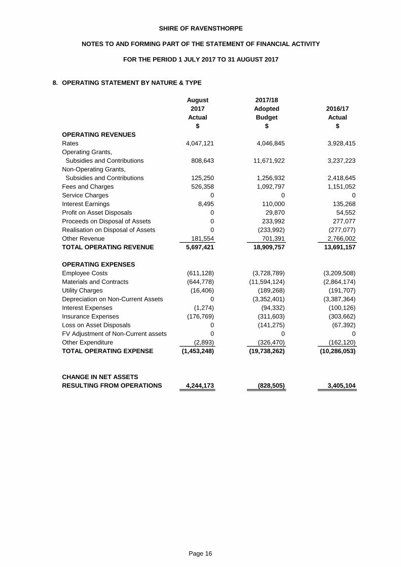
8.
August 2017/18
2017 Adopted 2016/17
Actual Budget Actual
$ $ $
OPERATING REVENUES
Rates 4,047,121 4,046,845 3,928,415
Operating Grants,
Subsidies and Contributions 808,643 11,671,922 3,237,223
Non-Operating Grants,
Subsidies and Contributions 125,250 1,256,932 2,418,645
Fees and Charges 526,358 1,092,797 1,151,052
Service Charges 0 0 0
Interest Earnings 8,495 110,000 135,268
Profit on Asset Disposals 0 29,870 54,552
Proceeds on Disposal of Assets 0 233,992 277,077
Realisation on Disposal of Assets 0 (233,992) (277,077)
Other Revenue 181,554 701,391 2,766,002
TOTAL OPERATING REVENUE 5,697,421 18,909,757 13,691,157
OPERATING EXPENSES
Employee Costs (611,128) (3,728,789) (3,209,508)
Materials and Contracts (644,778) (11,594,124) (2,864,174)
Utility Charges (16,406) (189,268) (191,707)
Depreciation on Non-Current Assets 0 (3,352,401) (3,387,364)
Interest Expenses (1,274) (94,332) (100,126)
Insurance Expenses (176,769) (311,603) (303,662)
Loss on Asset Disposals 0 (141,275) (67,392)
FV Adjustment of Non-Current assets 0 0 0
Other Expenditure (2,893) (326,470) (162,120)
TOTAL OPERATING EXPENSE (1,453,248) (19,738,262) (10,286,053)
CHANGE IN NET ASSETS
RESULTING FROM OPERATIONS 4,244,173 (828,505) 3,405,104
NOTES TO AND FORMING PART OF THE STATEMENT OF FINANCIAL ACTIVITY
FOR THE PERIOD 1 JULY 2017 TO 31 AUGUST 2017
OPERATING STATEMENT BY NATURE & TYPE
SHIRE OF RAVENSTHORPE
Page 16

SHIRE OF RAVENSTHORPE
NOTES TO AND FORMING PART OF THE STATEMENT OF FINANCIAL ACTIVITY
FOR THE PERIOD 1 JULY 2017 TO 31 AUGUST 2017
9. STATEMENT OF FINANCIAL POSITION
August
2017 2016/17
Actual Actual
$ $
CURRENT ASSETS
Cash and Cash Equivalents 4,664,387 4,997,076
Trade and Other Receivables 4,945,877 480,697
Inventories 32,862 14,700
TOTAL CURRENT ASSETS 9,643,126 5,492,473
NON-CURRENT ASSETS
Other Receivables 23,206 23,206
Inventories 0 0
Property, Plant and Equipment 33,182,253 33,177,450
Infrastructure 46,025,951 45,932,469
TOTAL NON-CURRENT ASSETS 79,231,410 79,133,125
TOTAL ASSETS 88,874,536 84,625,598
CURRENT LIABILITIES
Trade and Other Payables 446,762 376,047
Long Term Borrowings 127,957 193,909
Provisions 436,224 436,224
TOTAL CURRENT LIABILITIES 1,010,943 1,006,180
NON-CURRENT LIABILITIES
Trade and Other Payables 0 0
Long Term Borrowings 1,896,049 1,896,049
Provisions 85,140 85,140
TOTAL NON-CURRENT LIABILITIES 1,981,189 1,981,189
TOTAL LIABILITIES 2,992,132 2,987,369
NET ASSETS 85,882,404 81,638,229
EQUITY
Trust Imbalance 0 0
Retained Surplus 41,791,442 37,555,053
Reserves - Cash Backed 3,403,387 3,395,602
Revaluation Surplus 40,687,574 40,687,574
TOTAL EQUITY 85,882,404 81,638,229
Page 17

10. FINANCIAL RATIOS
2018
YTD
2017 2016 2015
Current Ratio 10.59 2.16 1.64 1.37
Operating Surplus Ratio 1.47 2.71 (0.24) 2.15
The above ratios are calculated as follows:
Current Ratio Current assets minus restricted current assets
Current liabilities minus liabilities associated
with restricted assets
Operating Surplus Ratio operating revenue minus operating expense
own source operating revenue
SHIRE OF RAVENSTHORPE
NOTES TO AND FORMING PART OF THE STATEMENT OF FINANCIAL ACTIVITY
FOR THE PERIOD 1 JULY 2017 TO 31 AUGUST 2017
Page 18

SHIRE OF RAVENSTHORPE
LOCAL PLANNING STRATEGY
AMENDMENT NO. 1

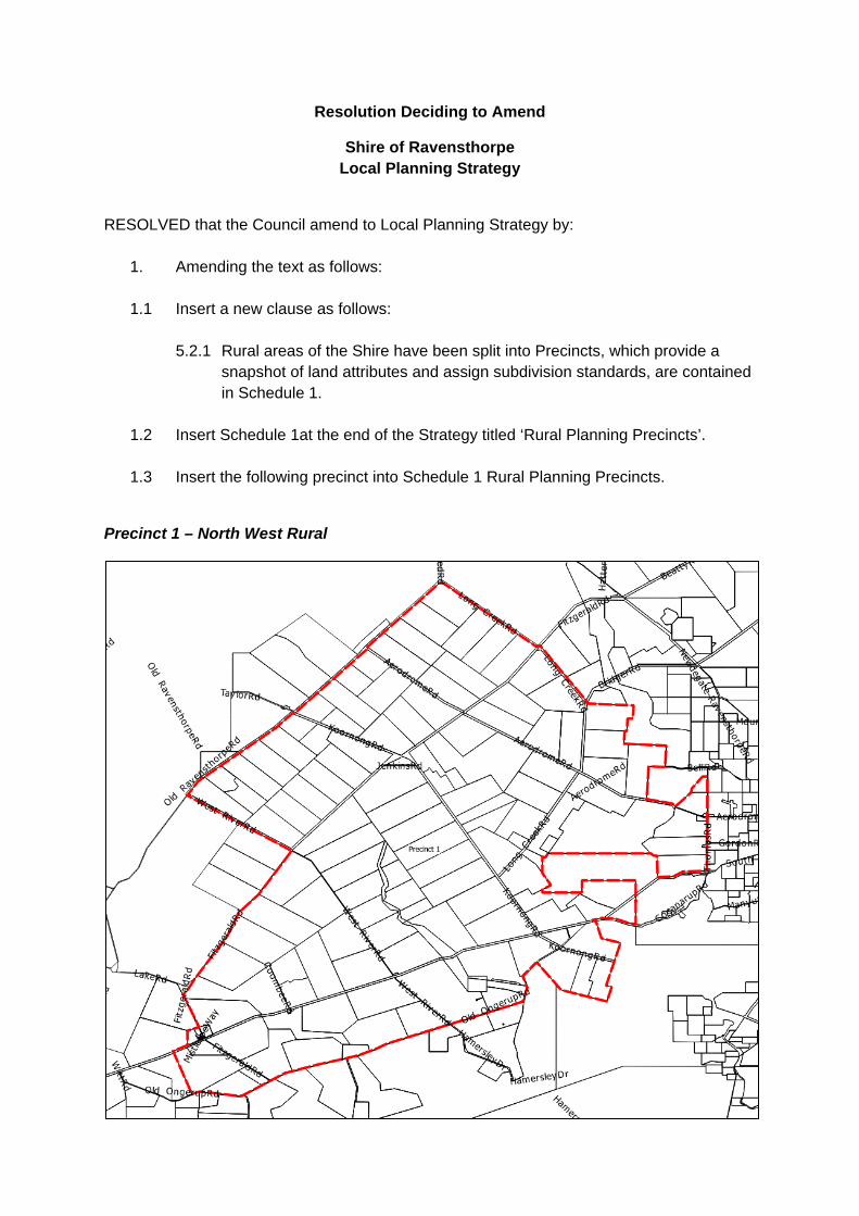
Resolution Deciding to Amend
Shire of Ravensthorpe Local Planning Strategy
RESOLVED that the Council amend to Local Planning Strategy by:
1. Amending the text as follows: 1.1 Insert a new clause as follows:
5.2.1 Rural areas of the Shire have been split into Precincts, which provide a snapshot of land attributes and assign subdivision standards, are contained in Schedule 1.
1.2 Insert Schedule 1at the end of the Strategy titled ‘Rural Planning Precincts’.
1.3 Insert the following precinct into Schedule 1 Rural Planning Precincts.
Precinct 1 – North West Rural

Objectives: To recognise existing land uses within the Precinct and make provision for subdivision.
Background
The North West Rural Precinct is located in the north western corner of the Shire, adjacent to the Shires of Lake Grace and Jerramungup.
Annual rainfall is approximately 450mm per annum.
The soils of the precinct are generally classified as Jerramungup 3, 8 or 9, Upper Fitzgerald 3, 5 or 7 subsystems to the South, Jerramungup 1 or 3, Upper Fitzgerald 4, 5, 6 or 7 subsystems to the centre of the Precinct and Upper Fitzgerald, Jerramungup 2, Newdegate 1 or 2 subsystems in the North.
Subsystem Description Annual Horticulture
Potential
Dryland Cropping Potential
Jerramungup 1 Level to only very gently inclined, often poorly drained, plain 0-3% gradient <9 m relief.
>70% of the land has moderate to very high capability
>70% of the land has moderate to very high capability
Jerramungup 2 Gently undulating to undulating dissected plain with hill slopes and hill crests. 1-5% gradient. 10-30 m relief
>70% of the land has moderate to very high capability
>70% of the land has moderate to very high capability
Jerramungup 3 Gently undulating to undulating landscape with occasional low rises with deep sand sheet pockets or linear sand dunes. 1-5% gradient. <9-15 m relief.
>70% of the land has moderate to very high capability
50-70% of the land has low to very low capability
Jerramungup 8 Bare rock and stony soils. >70% of the land has moderate to very high capability
50-70% of the land has moderate to very high capability
Jerramungup 9 Gently undulating terrain on deeply weathered granites and locally derived sediments. Mainly Alkaline grey shallow sandy duplexes under Mallee form eucalypts. Some lateritic sandplain and clayey soils under moort soils.
>70% of the land has moderate to very high capability
>70% of the land has moderate to very high capability
Newdegate 1 Flats and lower to mid slopes. Soils dominantly grey and yellow/brown duplex soils, usually alkaline, grey calcareous loamy earths and colluvial ironstone gravelly soils.
>70% of the land has moderate to very high capability
>70% of the land has moderate to very high capability
Newdegate 2 Lower to upper slopes, broad crests and upland plains. Soils are mainly grey and yellow/brown sandy duplex soils, often alkaline with hardsetting surfaces, and duplex sandy gravels.
>70% of the land has moderate to very high capability
50-70% of the land has moderate to very high capability
Upper Fitzgerald Valleys and breakaways, in the Jerramungup Sandplain Zone, with alkaline grey shallow
>70% of the land has moderate to very high capability
>70% of the land has moderate to very high capability

duplex (loamy and sandy) and grey shallow duplex (loamy and sandy). Woodland, mallee scrub and heath.
Upper Fitzgerald 3
Deeply dissected river valleys >70% of the land has moderate to very high capability
50-70% of the land has moderate to very high capability
Upper Fitzgerald 4
Gently undulating upper valley slopes and headwater rises, including some valley flats (salt affected).
50-70% of the land has low to very low capability
>70% of the land has low to very low capability
Upper Fitzgerald 5
Head water rises with long, moderately inclined, (converging) slopes. Deep and shallow gravelly and sandy duplex soils and hardsetting, non cracking grey clays.
>70% of the land has moderate to very high capability
50-70% of the land has moderate to very high capability
Upper Fitzgerald 6
Valley slopes and hill crests, with granitic rock outcrops or break-aways. 3-10% gradient 12-40 m relief. Rock exposures / outcrops include granite, gneiss and dolerite.
>70% of the land has moderate to very high capability
>70% of the land has low to very low capability
Upper Fitzgerald 7
Very gently undulating upland plain (interfluves).
>70% of the land has moderate to very high capability
>70% of the land has moderate to very high capability

The land is considered overall to have negligible flood risk and good drainage however there are localised areas at up to 50% -70% risk of poor drainage and a 0% - 3% risk of salinity although there are portions of the precinct with a higher risk of salinity at 50% - 70% (generally correlating to the areas of poor drainage).
Median lot size in the precinct is 1070 ha.
Strategy
• Support the existing land use patterns throughout the Precinct.
Actions
Subdivision to a minimum area of 400 ha may be considered or alternatively all subdivision is to comply with the provisions of State Planning Policy 2.5 and Development Control Policy 3.4.
All lots created must have access to a gazetted road. Battle-axe access legs should be avoided in bushfire prone areas. Where no alternative exists the requirements of State Planning Policy 3.7 will apply.

Precinct 2 – Fitzgerald
Objectives: To recognise the intrinsic environmental value and tourism potential of the National Park.
Background
Fitzgerald River National Park is one the largest and most botanically significant national parks in Australia. The park covers an area of 297,244 ha and is one of the most botanically significant national parks in Australia. Approximately 15% of the State’s described plant species are found within the park, 75 of which occur nowhere else.
Fitzgerald River National Park is an internationally recognised biosphere reserve under the United Nations Educational and Scientific Organisation’s Man and the Biosphere Programme.
Strategy
• Support the ongoing use of the land for community benefit. • Support the ongoing use of the land for low key tourism uses.

Actions
No subdivision is permitted within this Precinct.

Precinct 3 – Central North Rural
Objectives: To recognise existing land uses within the Precinct and make provision for subdivision.
Background
The Central North Rural Precinct is located in the central north of the Shire, adjacent to the Shire of Lake Grace in part.
The South West of the precinct contains a large area of Parklands and Recreation Reserve with a smaller reserve towards the North East of the precinct for Conservation.
Annual rainfall is approximately ranges from 450mm in the south to 400mm per annum in the North.
The soils of the precinct are generally classified as Lillian 1b, 1c, 1d, 2 or 6, Oldfield 2, 4 or 6. Kybulup 1 2 or 6 and Ravensthorpe 2 and 6 subsystems in the Western half of the precinct , Oldfield 1, 2, 3 or 4, Newdegate 1 or 2 and Ravensthorpe 1, 2 or 3 subsystems in the Eastern half of the precinct.
Subsystem Description Annual Horticulture
Potential
Dryland Cropping Potential
Kybulup 1 Low rises and undulating plain many headwaters tributaries.
>70% of the land has moderate to very high capability
>70% of the land has moderate to very high capability

Kybulup 2 Remanent lateritic sandplain.
>70% of the land has moderate to very high capability
50-70% of the land has moderate to very high capability
Kybulup 6 Bare rock and stony soils.
50-70% of the land has low to very low capability
>70% of the land has low to very low capability
Lillian 1b Internally drained level to very gently inclined plain (with some small alluvial valleys 600 to 2000 m wide). Dominant soils include shallow alkaline grey sandy and loamy duplex soils.
50-70% of the land has low to very low capability
50-70% of the land has low to very low capability
Lillian 1c Internally drained level to gently undulating plain; dominantly yellow/brown sandy and loamy duplex soils, with minor cracking and non cracking clays; Mallee-mallett (sandplain & gravelly soil associated vegetation) with low scrub.
>70% of the land has moderate to very high capability
>70% of the land has moderate to very high capability
Lillian 1d Internally drained gently undulating peneplain with numerous large lunettes and associated sand dunes. Dominantly deep sands.
>70% of the land has moderate to very high capability
>70% of the land has moderate to very high capability
Newdegate 1 Flats and lower to mid slopes. Soils dominantly grey and yellow/brown duplex soils, usually alkaline, grey calcareous loamy earths and colluvial ironstone gravelly soils.
>70% of the land has moderate to very high capability
>70% of the land has moderate to very high capability
Newdegate 2 Lower to upper slopes, broad crests and upland plains. Soils are mainly grey and yellow/brown sandy duplex soils, often alkaline with hardsetting surfaces, and duplex sandy gravels.
>70% of the land has moderate to very high capability
50-70% of the land has moderate to very high capability
Oldfield 1 Undulating rises and plains in places increasing to rolling rises with incised ephemeral streams. Alkaline grey shallow sandy duplex, minor grey shallow sandy duplex, duplex sandy gravels, and reddish brown non-cracking clays
>70% of the land has moderate to very high capability
>70% of the land has moderate to very high capability
Oldfield 2 Very gently to gently inclined very low rises to gently undulating plain in upper landscape positions externally drained. Alkaline grey and grey shallow sandy duplex soils and minor ironstone gravels and reddish brown non-cracking clays
>70% of the land has moderate to very high capability
>70% of the land has moderate to very high capability
Oldfield 3 Level occasionally very gently undulating sandplain, occasional small sandsheets in upper landscape positions. Grey deep sandy duplex
>70% of the land has moderate to very high capability
50-70% of the land has low to very low capability

(gravelly) soils, duplex sandy gravels and deep sandy gravels associated pale deep sands and sandy duplexes.
Oldfield 4 Very gently undulating plain increasing to gently undulating rises near creeklines. Grey shallow sand duplex soils usually alkaline with minor grey shallow loamy duplex soils, reddish brown non-cracking clays and bare rock.
>70% of the land has moderate to very high capability
>70% of the land has moderate to very high capability
Oldfield 6 Undulating (to gently undulating) rises comprising gentle slopes and crests with rock outcrop exposures and shallow gravelly soils. Sandy gravel and stony soils with occasional bare rock.
50-70% of the land has moderate to very high capability
50-70% of the land has low to very low capability
Ravensthorpe 1 Ridge line and upper slopes.
50-70% of the land has moderate to very high capability
50-70% of the land has moderate to very high capability
Ravensthorpe 2 Undulation plain and low hills colluvial slopes.
50-70% of the land has low to very low capability
50-70% of the land has low to very low capability
Ravensthorpe 3 Hills of greenstone and tertiary sediments.
>70% of the land has moderate to very high capability
>70% of the land has moderate to very high capability
Ravensthorpe 6 Areas of significant rock outcrop (Granite domes and gravelly soils).
50-70% of the land has moderate to very high capability
50-70% of the land has moderate to very high capability

The land is considered overall to have negligible flood risk and good drainage however there are localised areas at up to 10% - 30% risk of poor drainage and a 0% - 3% risk of salinity although there are portions of the precinct with a higher risk of salinity at 10% - 30% (generally correlating to the areas of poor drainage).
Median lot size in the precinct is 608 ha.
Strategy
• Support the existing land use patterns throughout the Precinct.
Actions
Subdivision to a minimum area of 600 ha may be considered or alternatively all subdivision is to comply with the provisions of State Planning Policy 2.5 and Development Control Policy 3.4.
All lots created must have access to a gazetted road. Battle-axe access legs should be avoided in bushfire prone areas. Where no alternative exists the requirements of State Planning Policy 3.7 will apply.
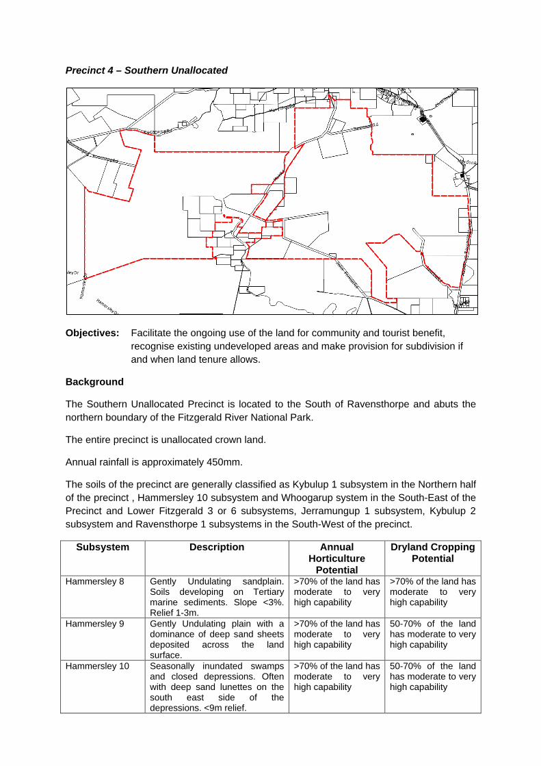
Precinct 4 – Southern Unallocated
Objectives: Facilitate the ongoing use of the land for community and tourist benefit, recognise existing undeveloped areas and make provision for subdivision if and when land tenure allows.
Background
The Southern Unallocated Precinct is located to the South of Ravensthorpe and abuts the northern boundary of the Fitzgerald River National Park.
The entire precinct is unallocated crown land.
Annual rainfall is approximately 450mm.
The soils of the precinct are generally classified as Kybulup 1 subsystem in the Northern half of the precinct , Hammersley 10 subsystem and Whoogarup system in the South-East of the Precinct and Lower Fitzgerald 3 or 6 subsystems, Jerramungup 1 subsystem, Kybulup 2 subsystem and Ravensthorpe 1 subsystems in the South-West of the precinct.
Subsystem Description Annual Horticulture
Potential
Dryland Cropping Potential
Hammersley 8 Gently Undulating sandplain. Soils developing on Tertiary marine sediments. Slope <3%. Relief 1-3m.
>70% of the land has moderate to very high capability
>70% of the land has moderate to very high capability
Hammersley 9 Gently Undulating plain with a dominance of deep sand sheets deposited across the land surface.
>70% of the land has moderate to very high capability
50-70% of the land has moderate to very high capability
Hammersley 10 Seasonally inundated swamps and closed depressions. Often with deep sand lunettes on the south east side of the depressions. <9m relief.
>70% of the land has moderate to very high capability
50-70% of the land has moderate to very high capability

Jerramungup 1 Level to only very gently inclined, often poorly drained, plain 0-3% gradient <9 m relief.
>70% of the land has moderate to very high capability
>70% of the land has moderate to very high capability
Kybulup 1 Low rises and undulating plain many headwaters tributaries.
>70% of the land has moderate to very high capability
>70% of the land has moderate to very high capability
Kybulup 2 Remanent lateritic sandplain. >70% of the land has moderate to very high capability
50-70% of the land has moderate to very high capability
Lower Fitzgerald 3
Deeply incised valleys (<20m deep) with cliffs and breakaways, together with a rejuvenated landscape comprising gently to moderately inclined colluvial slopes and small alluvial plains.
>70% of the land has moderate to very high capability
50-70% of the land has moderate to very high capability
Lower Fitzgerald 6
Valley slopes and hill crests, with granitic rock outcrops or break-aways. 3-10% gradient 12-40 m relief. Rock exposures / outcrops include granite, gneiss and dolerite.
50-70% of the land has low to very low capability
50-70% of the land has low to very low capability
Ravensthorpe 1 Ridge line and upper slopes. 50-70% of the land has moderate to very high capability
50-70% of the land has moderate to very high capability
Ravensthorpe 2 Undulation plain and low hills colluvial slopes.
50-70% of the land has low to very low capability
50-70% of the land has low to very low capability
Whoogarup Mountains and hills on Proterozoic quartzite and metasediments in the Barren Ranges, with bare rock, stony soil, grey deep sandy duplex and shallow sand. Scrub heath and mallee.
>70% of the land has low to very low capability
>70% of the land has low to very low capability
The land is considered overall to have negligible flood risk and good drainage however there are localised areas at up to 10% - 30% flood risk, in the south western portion of the

precinct, 10% - 30% poor drainage in the south western and south eastern portion of the precinct. There is a 0% - 3% risk of salinity throughout the precinct.
Strategy
• Support the existing land use patterns throughout the Precinct. Actions
Subdivision to a minimum area of 1,000 ha may be considered or alternatively all subdivision is to comply with the provisions of State Planning Policy 2.5 and Development Control Policy 3.4.
All lots created must have access to a gazetted road. Battle-axe access legs should be avoided in bushfire prone areas. Where no alternative exists the requirements of State Planning Policy 3.7 will apply.

Precinct 5 – Hopetoun North
Objectives: To recognise existing land uses within the Precinct and make provision for subdivision.
Background
The Hopetoun North Precinct is located to the north of Hopetoun.
The precinct is bounded to the West by the Fitzgerald River National Park, East by the Jerdacuttup River and to the North by Unallocated Crown Land and Conservation Reserve.
Rainfall in the precinct is approximately 500mm per annum.
The soils of the precinct are generally classified as Hamersley 9 with smaller areas of Hammersley 10 and Whoogarup subsystems in the North third of the precinct, to the south of this is an area of Hammersley 1 and 8 subsystem, south of that is an area of Munglinup 2 subsystem and the southern area of the precinct is the Munglinup 5 subsystem. The Young 3 and Gore 2 and 3 subsystems are along the eastern boundary of the precinct along the Jerdacuttup River.
Subsystem Description Annual Horticulture
Potential
Dryland Cropping Potential
Gore 2 Solonetzic yellow mottled duplex 50-70% of the land 50-70% of the land

soils. has low to very low capability
has low to very low capability
Gore 3 Uniform sands with a yellow podzolic B horizon.
>70% of the land has low to very low capability
>70% of the land has low to very low capability
Hammersley 1 Level plain, including some small seasonally inundated closed depressions <9m relief, 0-1% gradient.
>70% of the land has moderate to very high capability
>70% of the land has moderate to very high capability
Hammersley 8 Gently Undulating sandplain. Soils developing on Tertiary marine sediments. Slope <3%. Relief 1-3m
>70% of the land has moderate to very high capability
>70% of the land has moderate to very high capability
Hammersley 9 Gently Undulating plain with a dominance of deep sand sheets deposited across the land surface.
>70% of the land has moderate to very high capability
50-70% of the land has moderate to very high capability
Munglinup 2 Gently undulating plain and rises with ocassional gravelly hillocks. Grey deep and shallow sandy duplex (gravelly) soils and duplex sandy gravels, associated pale deep sands some alkaline grey shallow sandy duplex soils.
>70% of the land has moderate to very high capability
50-70% of the land has low to very low capability
Munglinup 5 Level and gently undulating plain of low relief (<9M) with occasional isolated hillocks. Grey deep sandy duplex (gravelly) soils with associated pale deep sands and minor duplex sandy gravels and saline wet soils
50-70% of the land has low to very low capability
>70% of the land has low to very low capability
Whoogarup Mountains and hills on Proterozoic quartzite and metasediments in the Barren Ranges, with bare rock, stony soil, grey deep sandy duplex and shallow sand. Scrub heath and mallee.
>70% of the land has low to very low capability
>70% of the land has low to very low capability
Young 3 Well drained uniform sands to sandy loams on flat alluvial flood plains.
>70% of the land has moderate to very high capability
>70% of the land has low to very low capability

The land is considered overall to have negligible flood risk and good drainage however there are localised areas at up to 3% - 10% flood risk and 10% - 30% poor drainage in the southern portion of the precinct. There is a 10% - 30% risk of salinity in the portion of the precinct with poor drainage.
Median lot size in the precinct is 300 ha although lots sizes tend to increase towards the northern portion of the precinct.
Strategy
• Support the existing land use patterns throughout the Precinct.
Actions
Subdivision to a minimum area of 300 ha may be considered or alternatively all subdivision is to comply with the provisions of State Planning Policy 2.5 and Development Control Policy 3.4.
All lots created must have access to a gazetted road. Battle-axe access legs should be avoided in bushfire prone areas. Where no alternative exists the requirements of State Planning Policy 3.7 will apply.

Precinct 6 – Northern Unallocated
Objectives: Facilitate the ongoing use of the land for community and tourist benefit, recognise existing undeveloped areas and make provision for subdivision if and when land tenure allows.
Background
The Northern Unallocated Precinct is located to the North of Ravensthorpe and abuts the Shire of Esperance (Cascade Road).
The entire precinct is unallocated crown land.
Annual rainfall is approximately 400mm.
The soils of the precinct are generally classified as Hope South A, Newdegate 2 and Lillian 1 subsystem in the North western portion of the precinct, the central area of the precinct is Oldfield 1 subsystem and the North eastern portion of the precinct is Scaddan 4 and 6 subsystems. Along the western boundary of the precinct there are soils classified as Oldfield 2 and the southern boundary are areas of Munglinup 2, Oldfield 4, Scaddan 2 and 4 and Young 1 subsystems.
Subsystem Description Annual Horticulture
Potential
Dryland Cropping Potential
Hope South A Alluvium, salt lakes, flats and minor dunes in broad valley floors on granitic basement. Soils are mainly alkaline grey to brown deep and shallow sandy duplexs and calcareous earths vegetated by Salmon gums,
N/A N/A

Gimlet, York gum and Acacia sp.
Lillian 1 Level plains with minor dissection (including some narrow valleys). The dominant soil is an Alkaline grey shallow sandy duplex, with small proportions of Alkaline grey deep sandy duplex soils, pale deep sands and calcareous loamy earths.
N/A N/A
Lillian 2 Level to very gently inclined plains in lower slope positions. Stream channels where present are incipient and drain to adjoining playa lakes; Alkaline grey shallow sandy duplex soils and associated calcareous loamy earth.
N/A N/A
Munglinup 2 Gently undulating plain and rises with occasional gravelly hillocks. Grey deep and shallow sandy duplex (gravelly) soils and duplex sandy gravels, associated pale deep sands some alkaline grey shallow sandy duplex soils.
N/A N/A
Newdegate 2 Lower to upper slopes, broad crests and upland plains. Soils are mainly grey and yellow/brown sandy duplex soils, often alkaline with hardsetting surfaces, and duplex sandy gravels.
N/A N/A
Oldfield 1 Undulating rises and plains in places increasing to rolling rises with incised ephemeral streams. Alkaline grey shallow sandy duplex, minor grey shallow sandy duplex, duplex sandy gravels, and reddish brown non-cracking clays
N/A N/A
Oldfield 2 Very gently to gently inclined very low rises to gently undulating plain in upper landscape positions externally drained. Alkaline grey and grey shallow sandy duplex soils and minor ironstone gravels and reddish brown non-cracking clays.
N/A N/A
Oldfield 4 Very gently undulating plain increasing to gently undulating rises near creek lines. Grey shallow sand duplex soils usually alkaline with minor grey shallow loamy duplex soils, reddish brown non-cracking clays and bare rock.
N/A N/A
Scaddan 4 Red alkaline gradational soils. >70% of the land has moderate to very high
>70% of the land has moderate to very high
capability capability Scaddan 6 Red-brown uniform siliceous
sands. >70% of the land has moderate to very high capability
>70% of the land has moderate to very high capability
Scaddan 8 Soil complex, Alkaline solodic duplex soils + Grey calcareous alkaline gradational soils.
N/A N/A
Young 1 Soil complex dominated by yellow to red solonetzic soils, on sloping valley sides.
N/A N/A
The land is assumed overall to have negligible flood risk and good drainage. There is a 0% - 3% risk of salinity throughout the precinct. A detailed land capability assessment and suitability assessment should be undertaken to fill gaps in information regarding this precinct prior to any further land being released.
Strategy
• Support the existing land use patterns throughout the Precinct. • If land is to be released in this precinct detailed land capability assessment and suitability
assessment should be undertaken. Actions
Subdivision to a minimum area of 2,000 ha may be considered (subject to a detailed land capability assessment and suitability assessment) or alternatively all subdivision is to comply with the provisions of State Planning Policy 2.5 and Development Control Policy 3.4.
All lots created must have access to a gazetted road. Battle-axe access legs should be avoided in bushfire prone areas. Where no alternative exists the requirements of State Planning Policy 3.7 will apply.

Precinct 7 – South East Rural
Objectives: To recognise existing land uses within the Precinct and make provision for subdivision.
Background
The South East Rural Precinct is located in the southwestern corner of the Shire, adjacent to the Shire of Esperance. There are convenience facilities in the small townsite of Munglinup located near the highway adjacent to the Shire of Esperance and there is a small development at Jerdacuttup approximately central to the precinct.
The most significant feature is this precinct is the Munglinup River, which forms part of the Oldfield-Munglinup Catchment. The catchment straddles the boundary the Ravensthorpe and Esperance Shires. The Oldfield - Munglinup Catchment contains large stands of vegetation, particularly along the river and creek lines. The remaining vegetation creates largely unbroken corridors from the head of the river to the coast. These corridors and other stands of native vegetation are to be retained. The majority of the vegetation is located within an A Class reserve that extends the length of the river. The coast within the precinct is located within A and C Class reserves.
Rainfall at the coast is approximately 550mm per annum, and this decreases to 450mm per annum in the northern section of the precinct. Fresh water supplies in the precinct are limited, particularly along the coast.
The soils of the precinct are generally classified as Young 1 and Munglinup 1 and 6 in the east of the precinct, Tooregullup 2 subsystem along the coast, Munglinup 3, 4 and 5 subsystems and Gore 2 and 3 subsystems in the south of the precinct and Ravensthorpe 2 and 3 subsystems, Munglinup 2 and 6 subsystems, Oldfield 1 subsystem, Young 3 subsystem, Kybulup 1 and 2, Whoogarup and Ravensthorpe 1, 2 and 3 subsystems in the remainder of the precinct.

Subsystem Description Annual Horticulture
Potential
Dryland Cropping Potential
Gore 2 Solonetzic yellow mottled duplex soils.
50-70% of the land has low to very low capability
50-70% of the land has low to very low capability
Gore 3 Uniform sands with a yellow podzolic B horizon.
>70% of the land has low to very low capability
>70% of the land has low to very low capability
Hammersley 1 Level plain, including some small seasonally inundated closed depressions <9m relief, 0-1% gradient
>70% of the land has moderate to very high capability
>70% of the land has moderate to very high capability
Hammersley 9 Gently Undulating plain with a dominance of deep sand sheets deposited across the land surface.
>70% of the land has moderate to very high capability
50-70% of the land has moderate to very high capability
Hammersley 10 Seasonally inundated swamps and closed depressions. Often with deep sand lunettes on the south east side of the depressions. <9m relief.
>70% of the land has moderate to very high capability
50-70% of the land has moderate to very high capability
Kybulup 1 Low rises and undulating plain many headwaters tributaries.
>70% of the land has moderate to very high capability
>70% of the land has moderate to very high capability
Kybulup 2 Remanent lateritic sandplain. >70% of the land has moderate to very high capability
50-70% of the land has low to very low capability
Munglinup 1 Externally drained plains and rises with gently inclined slopes some small level plains on upper slopes and catchment divides. Grey deep and shallow sandy duplex (gravelly) minor pale deep sands and gravelly duplex and deep sandy gravels
>70% of the land has moderate to very high capability
50-70% of the land has low to very low capability
Munglinup 2 Gently undulating plain and rises with occasional gravelly hillocks. Grey deep and shallow sandy duplex (gravelly) soils and duplex sandy gravels, associated pale deep sands some alkaline grey shallow sandy duplex soils
>70% of the land has moderate to very high capability
50-70% of the land has low to very low capability
Munglinup 3 Gently inclined hillslopes of low scarp (40m), externally well drained with short ephemeral streams. Grey deep and shallow sandy duplex (gravelly) with minor pale deep sands, duplex sandy gravels and Alkaline grey deep sandy duplex
>70% of the land has moderate to very high capability
50-70% of the land has low to very low capability
Munglinup 4 Gently undulating plain with numerous subdued sand sheets and occasional swamps. Grey deep sandy duplex (gravelly) soils with associated pale deep sands
>70% of the land has moderate to very high capability
50-70% of the land has moderate to very high capability

Munglinup 5 Level and gently undulating plain of low relief (<9M) with occasional isolated hillocks. Grey deep sandy duplex (gravelly) soils with associated pale deep sands and minor duplex sandy gravels and saline wet soils
50-70% of the land has low to very low capability
>70% of the land has low to very low capability
Munglinup 6 Gently sloping rises consisting of broad crests in upper landscape positions. Duplex sandy gravels and associated grey deep sandy (gravelly) duplex soils and minor pale deep sands
>70% of the land has moderate to very high capability
>70% of the land has low to very low capability
Oldfield 1 Undulating rises and plains in places increasing to rolling rises with incised ephemeral streams. Alkaline grey shallow sandy duplex, minor grey shallow sandy duplex, duplex sandy gravels, and reddish brown non-cracking clays
>70% of the land has moderate to very high capability
>70% of the land has moderate to very high capability
Oldfield 4 Very gently undulating plain increasing to gently undulating rises near creeklines. Grey shallow sand duplex soils usually alkaline with minor grey shallow loamy duplex soils, reddish brown non-cracking clays and bare rock.
>70% of the land has moderate to very high capability
>70% of the land has moderate to very high capability
Ravensthorpe 1 Ridge line and upper slopes. 50-70% of the land has moderate to very high capability
50-70% of the land has moderate to very high capability
Ravensthorpe 2 Undulation plain and low hills colluvial slopes.
50-70% of the land has low to very low capability
50-70% of the land has low to very low capability
Ravensthorpe 3 Hills of greenstone and tertiary sediments.
>70% of the land has moderate to very high capability
>70% of the land has moderate to very high capability
Scaddan 4 Red alkaline gradational soils. >70% of the land has low to very low capability
>70% of the land has moderate to very high capability
Tooregullup 2 Calcareous uniform sands and sandy loams, often peaty. Occur on open swales.
>70% of the land has low to very low capability
>70% of the land has low to very low capability
Whoogarup Mountains and hills on Proterozoic quartzite and metasediments in the Barren Ranges, with bare rock, stony soil, grey deep sandy duplex and shallow sand. Scrub heath and mallee.
>70% of the land has low to very low capability
>70% of the land has low to very low capability
Young 1 Soil complex dominated by yellow to red solonetzic soils, on sloping valley sides.
>70% of the land has low to very low capability
50-70% of the land has moderate to very high capability
Young 3 Well drained uniform sands to sandy loams on flat alluvial flood plains.
>70% of the land has moderate to very high capability
>70% of the land has low to very low capability

The land in the southern section of the precinct is considered to have poor site drainage, a high susceptibility to water logging and a 10% – 30% risk of salinity.
Median lot size in the precinct is 883 ha although lots sizes tend to decrease towards the western portion of the precinct.
Strategy
• Facilitate a mix of commercial and residential uses within the Munglinup town site. • Support the existing land use patterns throughout the Precinct.
Actions
Subdivision to a minimum area of 400 ha may be considered or alternatively all subdivision is to comply with the provisions of State Planning Policy 2.5 and Development Control Policy 3.4.
All lots created must have access to a gazetted road. Battle-axe access legs should be avoided in bushfire prone areas. Where no alternative exists the requirements of State Planning Policy 3.7 will apply.

Precinct 8 – North East Rural
Objectives: To recognise existing land uses within the Precinct and make provision for subdivision.
Background
The North East Rural Precinct is located in the north eastern corner of the Shire, adjacent to the Shire of Esperance.
The most significant feature is the Cheadanup Nature Reserve an A Class nature reserve which is located in the south eastern portion of the precinct. Under the Esperance and Recherche parks and reserves management plan it is proposed to expand this reserve by adding two addition lots which will result in an area of 7,139.27 ha.
Annual rainfall is approximately 450mm per annum.
The soils of the precinct are generally classified as Scaddan 6 Subsystem to the West, Scaddan 4 Subsystem running north-south through the centre of the precinct and Oldfield 1 predominately under the Cheadanup Nature Reserve.
Subsystem Description Annual Horticulture
Potential
Dryland Cropping Potential
Scaddan 2 Alkaline solodic duplex soils. >70% of the land has moderate to very high
>70% of the land has moderate to very high

capability
capability
Scaddan 4 Red alkaline gradational soils. >70% of the land has moderate to very high capability
>70% of the land has moderate to very high capability
Scaddan 6 Red-brown uniform siliceous sands.
>70% of the land has moderate to very high capability
>70% of the land has moderate to very high capability
Scaddan 8 Soil complex, Alkaline solodic duplex soils + Grey calcareous alkaline gradational soils.
>70% of the land has moderate to very high capability
50-70% of the land has moderate to very high capability
Oldfield 11 Undulating rises and plains in places increasing to rolling rises with incised ephemeral streams. Alkaline grey shallow sandy duplex, minor grey shallow sandy duplex, duplex sandy gravels, and reddish brown non-cracking clays.
N/A N/A
Oldfield 2 Very gently to gently inclined very low rises to gently undulating plain in upper landscape positions externally drained. Alkaline grey and grey shallow sandy duplex soils and minor ironstone gravels and reddish brown non-cracking clays.
>70% of the land has moderate to very high capability
>70% of the land has moderate to very high capability
Oldfield 4 Very gently undulating plain increasing to gently undulating rises near creeklines. Grey shallow sand duplex soils usually alkaline with minor grey shallow loamy duplex soils, reddish brown non-cracking clays and bare rock.
>70% of the land has moderate to very high capability
>70% of the land has moderate to very high capability
Munglinup 11 Externally drained plains and rises with gently inclined slopes some small level plains on upper slopes and catchment divides. Grey deep and shallow sandy duplex (gravelly) minor pale deep sands and gravelly duplex and deep sandy gravels.
N/A N/A
Young 1 Soil complex dominated by yellow to red solonetzic soils, on sloping valley sides.
>70% of the land has moderate to very high capability
50-70% of the land has moderate to very high capability
1 Soil characteristics have not been determined in the Cheadanup Nature Reserve or its proposed extension.

The land is considered to have negligible flood risk and good drainage and a 0% - 3% risk of salinity.
Median lot size in the precinct is 1,274 ha.
Strategy
• Support the existing land use patterns throughout the Precinct.
Actions
Subdivision to a minimum area of 600 ha may be considered or alternatively all subdivision is to comply with the provisions of State Planning Policy 2.5 and Development Control Policy 3.4.
All lots created must have access to a gazetted road. Battle-axe access legs should be avoided in bushfire prone areas. Where no alternative exists the requirements of State Planning Policy 3.7 will apply.
Remaining native vegetation is to be retained within the Young River Catchment.

Precinct 9 – Moir Road Rural
Objectives: To recognise existing land uses within the Precinct and restrict future subdivision.
Background
The Moir Road Rural Precinct is located in the south of the Ravensthorpe townsite and borders the Fitzgerald River National Park to the south. This precinct is surrounded by unallocated crown land.
Annual rainfall is approximately 450mm.
The soils of the precinct are generally classified as Hamersley 1, 2 and 9 subsystems and Kybulup 1 subsystem. Smaller areas of Ravensthorpe 1, 2 and 3 subsystems are present in the east of the precinct.
Subsystem Description Annual Horticulture
Potential
Dryland Cropping Potential
Hamersley 1 Level plain, including some small seasonally inundated closed depressions <9m relief, 0-1% gradient
>70% of the land has moderate to very high capability
>70% of the land has moderate to very high capability

Hamersley 2 Gently Undulating sandplain. Soils developing on Tertiary marine sediments. Slope <3%. Relief 1-3m
>70% of the land has moderate to very high capability
>70% of the land has moderate to very high capability
Hamersley 9 Gently Undulating plain with a dominance of deep sand sheets deposited across the land surface.
>70% of the land has moderate to very high capability
50-70% of the land has moderate to very high capability
Kybulup 1 Low rises and undulating plain many headwaters tributaries
>70% of the land has moderate to very high capability
>70% of the land has moderate to very high capability
Ravensthorpe 1 Ridge line and upper slopes. 50-70% of the land has moderate to very high capability
50-70% of the land has moderate to very high capability
Ravensthorpe 2 Undulation plain and low hills colluvial slopes.
50-70% of the land has low to very low capability
50-70% of the land has low to very low capability
Ravensthorpe 3 Hills of greenstone and tertiary sediments.
>70% of the land has moderate to very high capability
>70% of the land has moderate to very high capability
The land is considered to have negligible flood risk and good drainage and a 0% - 3% risk of salinity.

Median lot size in the precinct is 80 ha although lots sizes range from 28 ha to 514 ha.
Strategy
• Support the existing land use patterns throughout the Precinct.
Actions
No further subdivision is permitted within this Precinct.

Precinct 10 – Inner West
Objectives: To recognise existing land uses within the Precinct and make provision for subdivision.
Background
The Inner West Precinct is located in the west of Ravensthorpe.
Annual rainfall is approximately 430mm per annum.
The soils of the precinct are generally classified as Ravensthorpe 2 subsystem with Kybulup 1 and 2 subsystems to the North-West of the precinct. There are isolated pockets of the Ravensthorpe 3 subsystem.
Subsystem Description Annual Horticulture
Potential
Dryland Cropping Potential
Kybulup 1 Low rises and undulating plain many headwaters tributaries
>70% of the land has moderate to very high capability
>70% of the land has moderate to very high capability
Kybulup 2 Remanent lateritic sandplain >70% of the land has moderate to very high capability
50-70% of the land has low to very low capability

Ravensthorpe 1 Ridge line and upper slopes 50-70% of the land has moderate to very high capability
50-70% of the land has moderate to very high capability
Ravensthorpe 2 Undulation plain and low hills colluvial slopes.
50-70% of the land has low to very low capability
50-70% of the land has low to very low capability
Ravensthorpe 3 Hills of greenstone and tertiary sediments
>70% of the land has moderate to very high capability
>70% of the land has moderate to very high capability
The land is considered to have negligible flood risk and good drainage and a 0% - 3% risk of salinity.
Median lot size in the precinct is 127 ha with lots ranging from 10 ha to 646 ha.
Strategy
• Support the existing land use patterns throughout the Precinct.

Actions
Subdivision to a minimum area of 250 ha may be considered or alternatively all subdivision is to comply with the provisions of State Planning Policy 2.5 and Development Control Policy 3.4.
All lots created must have access to a gazetted road. Battle-axe access legs should be avoided in bushfire prone areas. Where no alternative exists the requirements of State Planning Policy 3.7 will apply.

Precinct 11 – Ravensthorpe Surrounds
Objectives: To recognise existing land uses within the Precinct and make provision for subdivision.
Background
The Ravensthorpe Surrounds Precinct is located in the west of Ravensthorpe.
Annual rainfall is approximately 430mm per annum.
The soils of the precinct are generally classified as Ravensthorpe 2 subsystem with Kybulup 1 subsystem to the South of the precinct. There are isolated pockets of the Ravensthorpe 1 subsystem to the north of the Precinct.
Subsystem Description Annual Horticulture
Potential
Dryland Cropping Potential
Ravensthorpe 1 Ridge line and upper slopes
50-70% of the land has moderate to very high capability
50-70% of the land has moderate to very high capability
Ravensthorpe 2 Undulation plain and low hills colluvial slopes
50-70% of the land has low to very low capability
50-70% of the land has low to very low capability
Kybulup 1 Low rises and undulating plain many headwaters tributaries
>70% of the land has moderate to very high capability
>70% of the land has moderate to very high capability

The Eastern and Northern Portions of the Precinct are considered to be highly mineralised.
The land is considered to have negligible flood risk and good drainage and a 0% - 3% risk of salinity.
Median lot size in the precinct is 34 ha with lots ranging from 2 ha to 587 ha. This variation in lot size is due to historical subdivision patterns adjacent to Ravensthorpe and along the south Coast Highway.
Strategy
• Support the existing land use patterns throughout the Precinct.
Actions
Subdivision to a minimum area of 200 ha may be considered or alternatively all subdivision is to comply with the provisions of State Planning Policy 2.5 and Development Control Policy 3.4.
All lots created must have access to a gazetted road. Battle-axe access legs should be avoided in bushfire prone areas. Where no alternative exists the requirements of State Planning Policy 3.7 will apply.

Precinct 12 – Cocanaurp Road Rural
Objectives: To recognise existing land uses within the Precinct and restrict future subdivision.
Background
The Cocanaurp Road Rural Precinct is located to the West Southwest of the Ravensthorpe townsite and is surrounded by timber reserve.
Annual rainfall is approximately 450mm.
The soils of the precinct are generally classified as the Kybulup 1 subsystem with a small occurrence of Ravensthorpe 2 soils in the North East portion of the precinct.
Subsystem Description Annual Horticulture
Potential
Dryland Cropping Potential
Kybulup 1 Low rises and undulating plain many headwaters tributaries
>70% of the land has moderate to very high capability
>70% of the land has moderate to very high capability
Ravensthorpe 2 Undulation plain and low hills colluvial slopes
50-70% of the land has low to very low capability
50-70% of the land has low to very low capability

The land is considered to have negligible flood risk and good drainage and a 0% - 3% risk of salinity.
Median lot size in the precinct is 18 ha although lots sizes range from 15 ha to 30 ha. This precinct consists of 5 lots that are in common ownership.
Strategy
• Support the existing land use patterns throughout the Precinct.
Actions
No further subdivision is permitted within this Precinct.
Dated this day of
Chief Executive Officer
Contents
1. Introduction ...................................................................................................... 1
2. Location ............................................................................................................ 1
3. Planning Context .............................................................................................. 1 3.1 Local Planning Scheme No.6 ............................................................... 1 3.2 Local Planning Strategy ....................................................................... 2 3.3 State Planning Policy 2.5: Rural Planning ............................................ 2 3.4 Development Control Policy 3.4: Subdivision of Rural Land ................ 2
4. Proposed Amendment ..................................................................................... 2
5. Conclusion ....................................................................................................... 3
1. Introduction
The Local Planning Strategy was endorsed by the Western Australian Planning Commission on the 20 November 2014. A number of enquires have been received in relation to the permissibility of rural subdivision in different areas of the Shire. The current planning framework does not provide for any rural subdivision.
This amendment has been created to insert subdivision control on a precinct basis.
2. Location
This amendment general applies to the rural areas of the Shire of Ravensthorpe as shown in the Location Plan below.
3. Planning Context
3.1 Local Planning Scheme No. 6
Notice of Final Approval of the Shire of Ravensthorpe Local Planning Scheme No. 6 (the Scheme) was published in the Government Gazette on the 11 July 2017. Whilst the Scheme assigns the ‘Rural’ zone to land it does not provide any standards for rural subdivision.

3.2 Local Planning Strategy
The Local Planning Strategy was endorsed by the Western Australian Planning Commission on the 20 November 2014. The Strategy does not provide any standards for rural subdivision and this amendment seeks to insert those controls.
3.3 State Planning Policy 2.5: Rural Planning
Clause 6.5 states that is the view of the WAPC that there are sufficient suitably sized and located rural lots to cater for intensive and emerging primary production land uses. Creation of new rural lots through ad-hoc, unplanned subdivision will not be permitted. In contemplating subdivision on rural land, the relevant parts of WAPC policy are:
(a) The creation of new or smaller rural lots will be by exception and in accordance with Development Control Policy 3.4: Subdivision of rural land;
(b) The creation of new or smaller rural lots by exception may be provided for in other State Planning Policies and/or a local planning strategy or scheme;
3.4 Development Control Policy 3.4: Subdivision of Rural Land
In determining subdivision applications, in addition to the provisions of this policy, the WAPC will have due regard to a local planning strategy or local rural strategy.
4. Proposed Amendment
The proposed amendment is self-explanatory. A new section is proposed to be inserted into the Local Planning Strategy referencing a new Schedule that will contain the Precinct Statements.
It is proposed to insert 12 Precinct Statements to provide strategic direction as well as subdivision criteria on a precinct basis. The format of each precinct is: • Objectives
The broad intent of the Precinct • Background
Any precinct specific details to set the context for the precinct
• Strategy What the precinct is seeking to achieve
• Actions
Identifies any actions required to address the Strategy

5. Conclusion
The proposed amendment to the Local Planning Strategy inserts precinct based controls for rural subdivision and is complementary to Local Planning Scheme No. 6. This will resolve the issue of having no rural subdivision guidance within the current Strategy or Local Planning Scheme No. 6. The proposed amendment is consistent with State Planning Policy 2.5: Rural Planning and Development Control Policy 3.4: Subdivision of Rural Land.

SHIRE OF RAVENSTHORPE
LOCAL PLANNING STRATEGY AMENDMENT NO. 1
ADVERTISING Certified for advertising by the Western Australian Planning Commission on Date: ________________________________ ______________________________________________________________ COUNCIL RECOMMENDED / SUBMITTED FOR APPROVAL Supported for submission to the Western Australian Planning Commission for endorsement by resolution of Shire of Ravensthorpe at the Meeting of Council held on the
________________________________ SHIRE PRESIDENT
________________________________ CHIEF EXECUTIVE OFFICER
______________________________________________________________ ENDORSEMENT Endorsed by the Western Australian Planning Commission on
________________________________ DELEGATED UNDER S.16 OF
THE PLANNING AND DEVELOPMENT ACT 2005

SHIRE OF RAVENSTHORPE
LOCAL PLANNING SCHEME NO. 6
AMENDMENT NO. 1

PLANNING AND DEVELOPMENT ACT 2005
RESOLUTION DECIDING TO AMEND A LOCAL PLANNING SCHEME
SHIRE OF RAVENSTHORPE
LOCAL PLANNING SCHEME No. 6 AMENDMENT No. 1
RESOLVED that the Council, in pursuance of Section 75 of the Planning and Development Act 2005, amend the above local planning scheme by:
1. Amending Clause 2.3 by numbering the line beneath the heading as ‘a)’
2. Amending Clause 2.3 by inserting as a new Clause b):
‘Despite anything contained in clause 2.2, a reserve may be used by the local government for the purposes of developing or maintaining public infrastructure.’
3. Amending the Scheme by adding a point iii to Clause 3.1 e) as follows: ‘iii. Seek to manage impacts such as noise, dust and odour within the zone.’
4. Amending the Scheme by deleting Clause 3.1 f) and renumber all subsequent clauses accordingly.
5. Amending Clause 3.2 Zoning Table by amending the order of Use
Classes to be sorted alphabetically and deleting the headings in bold within the table.
6. Amending Clause 3.2 Zoning Table by amending the permissibility of ‘Repurposed dwelling’ to ‘X’ in the ‘Residential, Rural Townsite and Mixed Use’ zones;
7. Amending Clause 3.2 Zoning Table by amending the permissibility of
‘Exhibition Centre’ to ‘A’ in the ‘Light Industry’ zone;
8. Amending Clause 3.2 Zoning Table by amending the permissibility of ‘Reception Centre’ to ‘X’ in the ‘Light Industry’ zone;
9. Amending Clause 3.2 Zoning Table by amending the permissibility of ‘Trade Supplies’ to ‘D’ in the ‘Light Industry’ zone;
10. Amending Clause 3.2 Zoning Table by deleting the ‘General Industry’ zone;

11. Amending Clause 3.2 Zoning Table by inserting ‘Renewable energy facility’ as an ‘X’ use in the ‘Residential’ and ‘Tourism’ zones, ‘A’ use in the ‘Rural Townsite’, ‘Mixed Use’ and ‘Rural Residential’ zones and as a ‘D’ use in the ‘Light Industry’ and ‘Rural’ zones.
12. Amending Clause 3.2 Zoning Table by inserting ‘Winery’ as an ‘X’
use in all zones except ‘Rural’ where it will be a ‘D’ use.
13. Amending the Scheme by inserting a new clause 61(1)(o) into Schedule A:
‘Development Approval is required for the placement of a shipping container on a lot except where it is:
(i) Fully enclosed within a building; (ii) To be used for the storage of plant, machinery or
building equipment where a building permit is current and construction is taking place, provided that the Shipping Container shall be removed within 14 days of completion of construction; or
(iii) A component of an otherwise approved commercial or industrial land use.’
14. Amending the Scheme by inserting a new clause 61(1)(p) into
Schedule A:
‘The signage and advertisements contained in Schedule 5 of this Scheme do not require development approval;’
15. Amending the Scheme by inserting a new clause 61(1)(q) into
Schedule A:
‘The use of land for Agriculture – Extensive purposes, the erection of windmills and the construction of water tanks, dams and soaks in the Rural zone in compliance with the setback standards contained in Schedule 2.’
16. Amending the Scheme by inserting a new clause 61(1)(r) into
Schedule A:
‘One satellite dish with a diameter of less than 1.2 metres;’
17. Amending the Scheme by inserting a new clause 61(1)(s) into Schedule A:
‘A renewable energy facility that is incidental in nature to the use of the land;’
18. Amending the Scheme by inserting a new clause 61(1)(t) into
Schedule A:
‘A solar hot water system.’

19. Amending the Scheme by replacing Clause 4.29 with a new heading of ‘Potable Water Supply’ with the following:
‘(a) All buildings intended for residential use shall be connected to a
reticulated water supply provided by a licensed water provider. Where a reticulated supply is not available buildings intended for residential use must include provision for the storage of water tanks of not less than 120,000 litres of capacity.
Where rainfall is to be used as the predominant source for a water storage tank, the minimum collection area, in terms of rain surface runoff, to service the tank, is to be provided. The collection area will normally comprise of the roof area of structures on the lot and may include the dwelling, outbuildings and any other structure capable of collecting and directing water into the tank.
The size of the collection area is to be based on the following calculation: Collection area (m2) = Average Household Water Consumption (L) divided by (0.85 multiplied by (local rainfall in mm -24mm). • Collection area (m2) is the minimum area for rain surface runoff
that is required to service the water tank. • Unless the Shire has determined otherwise the average
household water consumption will be 147,800L • 0.85 is the efficiency of the collection meaning a minimum of 85%
of the water will be collected (the Local Government may accept a greater efficiency rate if it can be demonstrated through design).
• Local rainfall is the average annual mean rainfall measured in millimetres (mm) guided by the nearest collection point provided by the bureau of Meteorology.
• 24mm is the anticipated loss through absorption and wetting of materials based on 2mm a month.
Potable water is of the quality specified under the Australian Drinking Water Quality Guidelines 2004 (as amended).’
20. Amending the Scheme by inserting a new clause 4.33 with the
heading ‘Site with more than One Street Frontage’ with the following:
‘(a) Where a development site has frontage to more than one street (except in the ‘Residential’ zone), the local government may: –
(i) Designate one of the streets to be a primary street for the
purpose of determining front setbacks;

(ii) Require that the specified front setbacks shall apply to each road;
(iii) Permit the setback on a secondary street to be reduced to half
of the specified front setback or averaged unless the site is adjacent to a State Highway, Limited Access Road, Primary Distributor Road of Local Distributor Road unless other more specific provisions in the Scheme apply; or
(iv) Refuse vehicular access to one of the roads.’
21. Amending the Scheme by inserting a new Clause 4.34 with the
heading ‘Reciprocal Parking and Shared Parking’ with the following:
‘(a) Subject to the Scheme, and the provisions of any relevant Local Planning Policy, the Local Government may exercise its discretion in granting planning approval to permit a proportion of the total number of car parking bays required under the Scheme to be provided jointly with any one or more other premises within a location, where it is demonstrated to the satisfaction of the Local Government that reciprocal and/or shared car parking would result in the same number of car parking bays required under the Scheme. Under this clause, “reciprocal” parking relates to land that is privately owned and “shared” parking relates to land which is owned by the Local Government or is vested with the Local Government for public parking.
(b) Subject to the Scheme, and the provisions of any relevant Local
Planning Policy, reciprocal and/or shared car parking shall only be permitted in locations where the following has been demonstrated to the satisfaction of the Local Government:
(i) reciprocal or shared off-street parking facilities are available in
the location that sufficiently accommodates the deficit in car parking required under the Scheme for the development/use;
(ii) the peak hours of operation of developments/uses so sharing are different and do not substantially overlap, whether or not the premises providing shared car parking separately have the prescribed number of parking bays; and
(iii) that a legally binding agreement has been made to enable
those reciprocal or shared off-street parking facilities to be used for that purpose. Where a reciprocal or shared parking arrangement is proposed as part of an application for planning approval, the written consent of the property owner of the reciprocal or shared parking facility must be in the form of a legally binding agreement between both parties that is

prepared to the satisfaction of the Local Government, and at the applicant’s own cost.
(c) Where an application proposes reciprocal and/or shared car parking
in accordance with this clause, the Local Government shall require a supporting development impact statement (with respect to traffic management and parking demand), to be prepared at the applicant’s cost and to the satisfaction of the Local Government as part of any application for planning approval.
(d) The Local Government may require that reciprocal access and
circulation arrangements are provided for any use/development of premises, where such arrangements are deemed necessary to improve traffic management, road safety or amenity.’
22. Amending the Scheme by inserting a new clause 4.35 with the
heading ‘Parking of Commercial Vehicles in Residential Areas’:
‘(a) No person shall park within the Residential zone a commercial vehicle without the planning approval of the local government. Where the commercial vehicle parking use is proposed in the Residential zone it shall comply with the following:
(i) not more than one such vehicle is to be parked on a lot;
(ii) the vehicle is to form an essential part of the lawful occupation
of an occupant of the dwelling and that occupation if carried on upon the lot does not contravene the Scheme;
(iii) the vehicle is to be parked behind the front building line and
effectively screened from view from outside the lot;
(iv) no part of the vehicle is to be parked on any portion of a right-of-way or public road contiguous with the lot;
(v) the vehicle is not to exceed 3.0 metres in height or 8.0 metres
in length;
(vi) no major/minor servicing of vehicles shall be undertaken on the lot; and
(vii) the vehicle is not brought to or taken from the lot between the
hours of midnight and 6.00 am.’
23. Amending the Scheme by inserting a new clause 4.36 with the heading ‘Effluent Disposal’ with the following:

‘(a) Where existing and proposed lots within the Scheme Area are not
connected to a reticulated sewerage system, on-site effluent disposal systems shall be to the specifications and satisfaction of the local government. The use of ‘non-standard’ effluent disposal systems may be required at the discretion of the local government and in any event the following requirements shall be satisfied:
(i) a 2 metre separation between the base of the leach drain and
the highest recorded groundwater level or bedrock; (ii) at least 100 metres horizontal separation between the effluent
disposal system and existing drains, water courses and water bodies;
(iii) the area around each effluent disposal system shall be planted with indigenous trees and shrubs and shall be maintained;
(iv) prevention of direct movement of wastewater and nutrients from the locality of each effluent disposal system.
The above requirements may be altered where soil amending techniques are introduced or alternatively the use of modified effluent disposal systems may be permitted in accordance with management guidelines prepared by the Local Government.
(b) Where on site effluent disposal systems are used, the system shall
be located within the prescribed building envelope or in another appropriate location specified by the Local Government.’
24. Amending the Scheme by inserting a new clause 4.37 with the
heading ‘Light Overspill with the following:
‘(a) Floodlights, spotlights and all other forms of lighting shall be constructed, oriented and controlled so as not to:
(i) adversely impact on the amenity of any adjacent residents; or
(ii) Cause a traffic hazard in the adjacent road network.’
25. Amending the Scheme by replacing Clause 4.25 with the following:
‘(a) Where a caretaker’s dwelling use is proposed it shall comply with the
following:
(i) A caretaker's dwelling must be incidental to the predominant use of the site.

(ii) Only one caretaker's dwelling is permitted on each lot.
(iii) The total plot ratio area of a caretaker's dwelling is 100m², measured from the external face of walls excluding verandahs and carports.
(iv) Verandahs and carports may be permitted, but if enclosed will
form part of the total calculated floor area.
(v) The Local Government may consider the use of notifications on title to advise prospective purchasers of potential impacts from noise, dust, odour or amenity that may arise from the location of a caretaker's dwelling within the zone.
(vi) The Local Government will not consider applications for
caretakers' dwellings prior to the primary site activity being either approved or constructed.
(vii) Where simultaneous approval has been granted by the Local
Government for both a caretaker's dwelling and the main activity on the same lot, the main activity must be developed and operational prior to occupation of the dwelling.
(viii) Caretaker's dwellings should be carefully sited and
constructed so the potential site (or estate) impacts from noise, dust, odour or amenity are minimised.
(ix) A caretaker's dwelling may only be occupied by the owner,
manager, lessee or employee (and immediate family thereof) of the lawfully established or approved land use.
(x) Where the primary site activity has ceased the occupation of
the caretaker’s dwelling is to cease.’
26. Amending the Scheme by replacing Clause 4.27 (Retaining the heading) with the following:
‘4.27.1 Second-hand dwellings
(a) Notwithstanding any other requirement of the Scheme, all Second-
hand dwellings require the planning approval of the local government. (b) Where a Second-hand dwelling use is proposed it shall comply with
the following in addition to any other relevant provision of the Scheme:

(i) A building that has a roof or wall sheeting or any other material
such as sound proofing or insulation, that contains asbestos, is not permitted to be relocated until those materials containing asbestos are removed and disposed of in the appropriate manner, prior to transportation.
(ii) The void area between the floor and natural ground levels is to be enclosed with brickwork, battens or other suitable materials as approved by the local government.
(c) When considering an application for planning approval for a second-
hand dwelling, the local government may impose conditions concerning:
(i) The external appearance and material finishes, the screening
of sub-floor spaces, the addition to or modification to the existing dwelling and the time frame imposed to complete specified work and connect the dwelling or building to lot services;
(ii) The provision of landscaping and/or screening of the building and/or site; and
(iii) The provision of a bond or bank guarantee in favour of the Local Government as surety for the completion of the building to a standard of presentation acceptable to the Local Government within a specified time.
(d) Where the provision of a bond or bank guarantee is required, the
Local Government shall refund the payment upon satisfactory completion of the necessary works.
4.27.2 Repurposed dwelling
(a) Notwithstanding any other requirement of the Scheme, all
Repurposed dwelling require the planning approval of the local government.
(b) Where a Repurposed dwelling use is proposed it shall comply with
the following:
(i) Within the Rural Residential zone only one Repurposed dwelling may be approved on a lot.
(ii) The Repurposed dwelling should be carefully sited and
constructed so the potential impacts from noise, dust, odour or amenity are minimised.

(iii) For the purposes of establishing whether a grouped dwelling is proposed a Repurposed dwelling will count as one dwelling.
(iv) Regardless of external wall materials, all roofs over the main
portion of the Repurposed dwelling are to have a pitch of 10º or greater.’
27. Amending the Scheme by replacing ‘4.31.1’ within Clause 4.30.2 with
‘4.30.1’
28. Amending the Scheme by replacing ‘4.31.1’ within Clause 4.30.3 with ‘4.30.1’
29. Amending the Scheme by inserting a new clause 4.36 with the heading ‘Shipping Container Requirements’:
(a) In considering an application for a shipping container, the Shire shall
take into account whether the appearance of the structure would be compatible with the character and visual amenity of the locality to which it is proposed to be sited. The Shire may refuse an application for such a structure if, in its opinion, the appearance of the structure would be incompatible with the character and visual amenity of the locality to which it is proposed to be relocated, notwithstanding any other provision of the Scheme.
(b) No shipping container shall be placed on any lot zoned Residential
other than in accordance with clause 61(1)(o). (c) Any approval granted for the placement of a shipping container on a
lot zoned Rural Residential shall be limited to a specific period of time, such time not exceeding 12 months.
(d) Not withstanding subclauses (b) and (c) where a shipping container
is clad and has the addition of a pitched roof or is permanently screened from public view it may receive planning approval subject to subclause (a).
(e) A shipping container shall not be used for any form of
accommodation unless a component of an otherwise approved development.
(f) A shipping container shall be adequately screened from the street
and shall not be stacked vertically unless otherwise approved.
(g) Where a shipping container has fallen into disrepair or become unsightly at the discretion of the local government, they shall be removed from the lot or suitably upgraded.

30. Amending the Scheme by inserting a new clause 4.36 with the heading ‘Outbuildings in the Residential and Rural Residential Zones’:
‘(a) Erection of an outbuilding on a Residential or Rural Residential zoned
lot is not permitted unless development approval has already been issued for the erection of a single house, grouped dwelling or multiple dwelling on the lot.’
31. Amending the Scheme by inserting a new clause 4.24.4 as follows:
‘Within the Rural zone Telecommunications Infrastructure is exempt from the setbacks assigned in Schedule 2.’
32. Amending the Scheme by renumbering the second Clause ‘5.1.1’ with Clause ‘5.1.2’
33. Amending the Scheme by inserting a new clause within Table 12 –
Special control areas in the Scheme as follows:
Name of area Purpose Objectives Additional Provisions
SCA5 – Undeveloped Rural Area
The purpose of SCA 10 is to provide guidance for land use and development within the undeveloped rural zoned areas of the Shire.
To provide for mining activity, low key eco-tourism uses, environmental conservation and agricultural land uses.
1. Application Requirements
Despite any other provision of the Scheme planning approval is required for all development. Land uses are to be assessed as follows:
(a) As P uses
Telecommunications infrastructure
(b) As D uses
Mining Operations Agriculture – Extensive Agriculture – Intensive Animal Husbandry – intensive Holiday House Repurposed dwelling Single House Second-hand dwelling Winery Workforce accommodation
(c) As I uses
Industry
(d) All other uses are to be
read as X uses in Table

No. 4 2. Relevant Considerations
In addition to provisions of the Scheme, the local government in considering applications for rezoning, subdivision or planning approval in SCA 5 is to have due regard to –
(a) results of scientific
research conducted by Department of Biodiversity Conservation and Attractions or other relevant authority;
(b) guidelines of the
Environmental Protection Authority for protection of the environment including but not limited to maintenance of water quality;
(c) guidelines of the
Department of Water and Environmental Regulation for protection of wetlands and waterways including but not limited to maintenance of water quality; and
(d) the potential for adverse
environmental impacts and the management of such potential impacts.
and shall determine applications for planning approval accordingly.
3. Development Requirements
(a) Minimum lot sizes will be as per the Local Planning Strategy.
(b) Minimum setbacks to
development will be 20m to all boundaries.
(c) The disposal of liquid
and/or solid wastes shall be carried out with an effluent disposal system approved by the Local Government and the

Health Department of Western Australia.
(d) A potable water supply
shall be provided to the satisfaction of the Local Government and in accordance with Clause 4.29 of the Scheme.
(e) Power will be generated on
site as there is no external service.
4. Referral of Applications
(a) Development application that require the clearing of native vegetation will be referred to the Department of Biodiversity Conservation and Attractions and the Department of Water and Environmental Regulation and the Local Government is to have due regard to recommendations and advice received from those authorities when determining applications.
34. Amending Clause 6.2 by inserting the following definition:
‘renewable energy facility’ means premises used to generate energy from a renewable energy source and includes any building or other structure used in, or in connection with, the generation of energy by a renewable resource. It does not include solar panels or a wind turbine located on a lot with a single house where the energy produced only supplies that house or private rural use or anemometers.’
35. Amending Clause 6.2 by inserting the following definition: ‘winery’ means premises used for the production of viticultural produce and associated sale of the produce;
36. Amending the Scheme by replacing ‘Ni’ within the front setback of
Non-residential uses in the Rural Townsite zone Schedule 2 with ‘Nil’.

37. Amending the Scheme by replacing ‘variable’ within the rear setback of Non-residential uses in the Rural Townsite zone Schedule 2 with ‘Nil’.
38. Amending the Scheme by replacing ‘variable’ within the landscaping of Non-residential uses in the Rural Townsite zone Schedule 2 with ‘10’.
39. Amending the Scheme by replacing ‘variable’ within the rear setback of Non-residential uses in the Mixed Use zone Schedule 2 with ‘Nil’.
40. Amending the Scheme by replacing ‘variable’ within the landscaping of Non-residential uses in the Mixed Use zone Schedule 2 with ‘10’.
41. Amending the Scheme by replacing ‘Variable’ within the Plot Ratio of Tourism in Schedule 2 with ‘0.75’.
42. Amending the Scheme by replacing ‘Variable’ within the Rear Setback of Tourism in Schedule 2 with ‘Nil(i)’.
43. Amend the Scheme by inserting a new box for ‘Tourism’ in Schedule 2 as follows: ‘(i) Where development adjoin a Residential zone the minimum setback shall be at the discretion of the local government.’
44. Amending the Scheme by deleting the row ‘General Industry’ in Schedule 2.
45. 10. Amending the Scheme by replacing ‘Variable’ within the Plot Ratio of Light Industry in Schedule 2 with ‘0.6’.
46. Amending the Scheme by inserting a new Schedule 5 with the
heading ‘Exempted Signage and Advertising’ as follows:
Land use and/or development
Exempted Signs Maximum Size
Dwellings One professional name-plate as appropriate
0.2m2
Home Occupation One advertisement describing the nature of the home occupation.
0.2m2
Places of Worship, Meeting Halls and Places of Public Assembly
One advertisement detailing the function and/or the activities of the institution concerned.
2.0m²
Shops, Showrooms and other uses appropriate to a Shopping Area
All advertisements affixed to the building below the top of the awning or, in the absence of an awning, below a line measured at 5 metres from the ground floor level of the building
Not Applicable

Industrial and Warehouse Premises
A maximum of four advertisements applied to or affixed to the walls of the building but not including signs which project above the eaves or the ridge of the roof of the building, and excluding signs projecting from a building and excluding signs which are connected to a pole, wall, or other building.
Total area of such advertisements is not to exceed 15m2 or 20% of the elevation of the building whichever is the lesser.
A maximum of two freestanding advertisement signs not exceeding 5 metres in height above ground level.
Maximum permissible total area is not to exceed 10m² and individual advertisement signs are not to exceed 6m².
Showroom, racecourses, major racing tracks, sports stadia, major sporting grounds and complexes
All signs provided that, in each case, the advertisement is not designed to be visible from outside the complex or facility concerned either from adjacent private land or from public places and streets.
Not Applicable
Public Places and Reserves
Signs (illuminated and non-illuminated) relating to the functions of Government, a responsible authority or the local government including those of a promotional nature constructed or exhibited by, or on behalf of any such body, and
Not Applicable
Signs (illuminated and non-illuminated) required for the management or control of traffic on any public road, car park, cycleway, railway or waterway where such signs have been constructed or exhibited by or at the direction of Government, a responsible authority or the local government, and
Not Applicable
Signs (illuminated and non-illuminated) required to be exhibited by or pursuant to any statute or regulation or the like made pursuant to powers contained within a statute provided that any such advertisement is constructed and/or exhibited strictly in accordance with the requirements specified therein.
Not Applicable
Advertisements within Buildings
All advertisements placed or displayed within buildings, which cannot ordinarily be seen by a person outside of those buildings.
Not Applicable

All classes of buildings other than single family dwelling
One advertising sign containing the name, number and address of the building, the purpose for which the building is uses or the name and address if the managing agent thereof.
0.2m2
Temporary Signs Temporary Signs Exempted Signs Maximum Size Building Construction Sites (signs displayed only for the duration of the construction) as follows: Dwellings One sign per street frontage containing
details of the project and the contractors undertaking the construction work.
2m²
Multiple dwellings, shops, commercial and industrial properties
One sign as for (a) above which may also include site security information.
5m²
Property transactions – Advertisement signs displayed for the duration of the period over which property transactions are offered and negotiated as follows: Dwellings One sign per street frontage for each
property relating to the sale, leasing or impending auction of the property at or upon which the sign is or the signs are displayed.
Each sign is not to exceed an area of 2m²
All other properties One sign as for (b) above. Each sign is not to exceed an area of 4m²
a. any sign which is the subject of an existing approval made prior to the
date of effect of this Policy;
b. any advertisement affixed to or painted on a shop window by the occupier of the shop and relating to the business carried on in the shop;
c. any sign within a building;
d. any building name sign on residential flats or home units which has a single line of letters not exceeding 300mm in height, fixed to the facade of the building;
e. any newspaper poster;
f. 1 freestanding sign (per building or business). The sign is to be placed or erected only to direct attention to a place, activity or event during the hours of that activity or event.
g. One (1) ‘rural producer sign’ displaying the name, street number and owners of the farm that does not exceed 4m2 in area.
h. All electoral signs erected up to four weeks before an election or referendum.

i. by the local government to advertise events or provide information of community interest.’
47. Amending the Scheme Map by showing all ‘General Industry’’ zoned
land as ‘Light Industry’ as depicted on the Amendment Map.
48. Amending the Scheme Map by showing SCA5 as depicted on the Amendment Map.
This amendment is a complex amendment under the provisions of regulation 35.(2) of the Planning and Development (Local Planning Schemes) Regulations 2015 for the following reason(s):
(c) an amendment relating to development that is of a scale, or will
have an impact, that is significant relative to development in the locality;
Dated this ___________________day of _____________________
_________________________ CHIEF EXECUTIVE OFFICER

SHIRE OF RAVENSTHORPE
LOCAL PLANNING SCHEME NO. 6
AMENDMENT NO. 1
PLANNING REPORT

1. INTRODUCTION
Notice of Final Approval of the Shire of Ravensthorpe Local Planning Scheme No. 6 (“the Scheme’) was published in the Government Gazette on 11 July 2017.
This amendment seeks insert a number of new and expanded provisions to improve consistency between Local Planning Scheme No. 6 and the Shire of Esperance’s Local Planning Scheme No. 24. A number of other modification are proposed to improve the clarity of the Scheme and to ensure the ease if its interpretation by the users of the document. A new Special Control Area has been introduced over the Unallocated Crown Land of the Shire that is zoned ‘Rural’. This approach inserts identical controls that are in Special Control Area No. 10 in the Shire of Esperance’s Local Planning Scheme No. 24. The deletion of all clauses relating to the ‘General Industry’ zone and conversion of all this land to ‘Light Industry’ is also undertaken by this amendment. Map modifications are proposed to reflect the changes made within the Scheme text. Corrections have also been made to several incorrect references.
2. PROPOSED SCHEME AMENDMENT 2.1 Amend the numbering of Clause 2.3
This modification is the renumbering of the clause to allow the insertion of a new clause as outlined under modification 2.2.
2.2 Amend Clause 2.3 by inserting as a new Clause b)
This modification inserts a new provision that allows a Shire managed reserve to be used for the purposes of developing or maintaining public infrastructure despite the purposes that is assigned for the reserve under the Scheme.
2.3 Amend the Scheme by adding a point iii to Clause 3.1 e)
This modification inserts a new objective into the ‘Light Industry’ zone to cater for its expansion to include the land formerly zoned ‘General Industry’. It is proposed to rezone all ‘General Industry’ zoned land to ‘Light Industry’ as the uses permitted in both zones are nearly identical. As a component of this all parts of the Scheme that reference the ‘General Industry’ zone require deletion.
2.4 Amend the Scheme by deleting Clause 3.1 f)
This modification deletes the objectives for the ‘General Industry’ zone. It is proposed to rezone all ‘General Industry’ zoned land to ‘Light Industry’ as the uses permitted in both zones are nearly identical. As a component of this all parts of the Scheme that reference the ‘General Industry’ zone require deletion.

2.5 Amend Clause 3.2 Zoning Table by amending the order of Use Classes
This modification resorts the Zoning Table so that land uses are sorted alphabetically. It is also proposed to remove the subheadings so that the Table reads as a traditional zoning table.
2.6 Amend Clause 3.2 Zoning Table by amending the permissibility of ‘Repurposed
dwelling’
This modification amends the permissibility of ‘repurposed dwelling’ to ‘X’ in the ‘Residential, Rural Townsite and Mixed Use’ zones. The use retains the same permissibility in all other zones.
2.7 Amend Clause 3.2 Zoning Table by amending the permissibility of ‘Exhibition
Centre’
This modification amends the permissibility of ‘Exhibition Centre’ to ‘A’ in the ‘Light Industry’ zone. It is proposed to rezone all ‘General Industry’ zoned land to ‘Light Industry’ as the proposed change is as a result of amalgamating the zones.
2.8 Amend Clause 3.2 Zoning Table by amending the permissibility of
‘Reception Centre’
This modification amends the permissibility of ‘Reception Centre’ to ‘X’ in the ‘Light Industry’ zone. It is proposed to rezone all ‘General Industry’ zoned land to ‘Light Industry’ as the proposed change is as a result of amalgamating the zones
2.9 Amend Clause 3.2 Zoning Table by amending the permissibility of ‘Trade
Supplies’
This modification amends the permissibility of ‘Trade Supplies’ to ‘A’ in the ‘Light Industry’ zone. It is proposed to rezone all ‘General Industry’ zoned land to ‘Light Industry’ as the proposed change is as a result of amalgamating the zones
2.10 Amend Clause 3.2 Zoning Table by deleting the ‘General Industry’ zone
This modification deletes the ‘General Industry’ zone from the Zoning Table. It is proposed to rezone all ‘General Industry’ zoned land to ‘Light Industry’ as the uses permitted in both zones are nearly identical. As a component of this all parts of the Scheme that reference the ‘General Industry’ zone require deletion
2.11 Amend Clause 3.2 Zoning Table by inserting ‘Renewable energy facility’
This modification introduces a renewable energy facility as a land use within the Zoning Table and assigns permissibilities based on zone.
2.12 Amend Clause 3.2 Zoning Table by inserting ‘Winery’
This modification introduces a renewable energy facility as a land use within the Zoning Table and assigns permissibilities based on zone.
2.13 Amend the Scheme by inserting a new clause 61(1)(o) into Schedule A
This modification incorporates exemptions for shipping containers where it not:
• Fully enclosed within a building; • To be used for the storage of plant, machinery or building equipment where
a building permit is current and construction is taking place, provided that the Shipping Container shall be removed within 14 days of completion of construction; or
• A component of an otherwise approved commercial or industrial land use.
This modification is related the incorporation of controls in relation to sea containers as part of this Amendment.
2.14 Amend the Scheme by inserting a new clause 61(1)(p) into Schedule A
This modification introduces an exemption for signage that is contained within a new Schedule that is proposed to be inserted into the Scheme. This approach was also taken in Scheme No. 5.
2.15 Amend the Scheme by inserting a new clause 61(1)(q) into Schedule A
This modification introduces an exemption for Agricultural activities within the ‘Rural’ zone. This clause exempts the use of land for ‘Agriculture – Extensive ‘purposes, the erection of windmills and the construction of water tanks, dams and soaks in the ‘Rural’ zone in compliance with the setback standards contained in Schedule 2.
2.16 Amend the Scheme by inserting a new clause 61(1)(r) into Schedule A:
This modification introduces an exemption for satellite dishes. The exemption applies where the proposed dish has a diameter of 1.2 metres or less.
2.17 Amend the Scheme by inserting a new clause 61(1)(s) into Schedule A:
This modification introduces an exemption for a ‘renewable energy facility’ that is incidental in nature to the use of the land.
2.18 Amend the Scheme by inserting a new clause 61(1)(t) into Schedule A:
This modification introduces an exemption for a solar hot water system. This exemption is included as based on the current exemptions any commercial premise would need development approval to install solar hot water.
2.19 Amend the Scheme by replacing Clause 4.29 with a new heading of ‘Potable
Water Supply’
This modification introduces a new potable water provision into the Scheme that is consistent with Statement of Planning Policy 2.5 Rural Planning and the associated Rural Planning Guidelines. It should be noted that the formula has had a slight modification with a reduced water consumption rate that reflects usage of tank water when compared to reticulated water.

2.20 Amend the Scheme by inserting a new clause 4.33 with the heading ‘Site
with more than One Street Frontage’
This modification introduces a new provision to provide controls for determining setbacks when a development site has more than one street frontage.
2.21 Amend the Scheme by inserting a new clause 4.34 with the heading
‘Reciprocal Parking and Shared Parking’
This modification introduces new provisions to manage Reciprocal Parking and Shared Parking. Currently the Scheme does not allow parking to be offset either by time of use or alternative sites and this provision allows this to occur.
2.22 Amend the Scheme by inserting a new clause 4.35 with the heading ‘Parking
of Commercial Vehicles in Residential Areas’
This modification introduces that no person shall park within the ‘Residential’ or ‘Rural Townsite’ zone a commercial vehicle without the development approval of the local government. Where the commercial vehicle parking use is proposed in the ‘Residential’ or ‘Rural Townsite’ a number of criteria are specified.
2.23 Amending the Scheme by inserting a new clause 4.36 with the heading
‘Effluent Disposal’
This modification introduces criteria for effluent disposal into the Scheme. These criteria relate on-site effluent disposal systems being to the specifications and satisfaction of the local government. Requirements for the use of ‘non-standard’ effluent disposal systems may be required at the discretion of the local government.
2.24 Amend the Scheme by inserting a new clause 4.37 with the heading ‘Light
Overspill’
This modification introduces a restriction on Floodlights, spotlights and all other forms of lighting shall be constructed, oriented and controlled so as not to adversely impact on the amenity of any adjacent residents or cause a traffic hazard in the adjacent road network.
2.25 Amend the Scheme by replacing Clause 4.25
This modification to the Scheme expands on the requirements for ‘caretakers dwellings’. The provision is an extension to the current clause and in particular requires that the when the main use of the site ceases the ‘caretakers dwelling’ approval is to cease.
2.26 Amend the Scheme by replacing Clause 4.27
This modification to the Scheme expands on the requirements for ‘Second-hand dwellings’ and ‘Repurposed dwelling’. The provisions retain the requirement for approval to be issued whilst providing a wider range of criteria by which to assess applications.
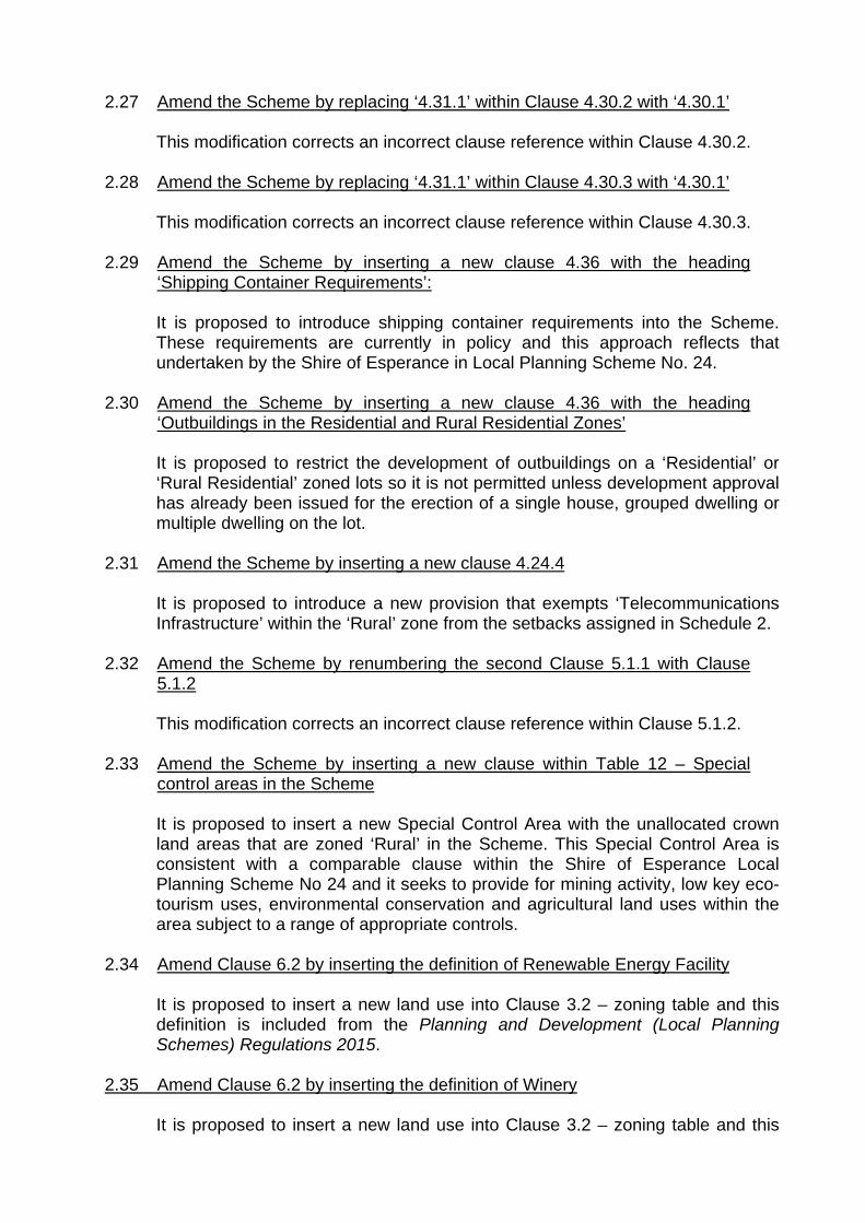
2.27 Amend the Scheme by replacing ‘4.31.1’ within Clause 4.30.2 with ‘4.30.1’
This modification corrects an incorrect clause reference within Clause 4.30.2. 2.28 Amend the Scheme by replacing ‘4.31.1’ within Clause 4.30.3 with ‘4.30.1’
This modification corrects an incorrect clause reference within Clause 4.30.3. 2.29 Amend the Scheme by inserting a new clause 4.36 with the heading
‘Shipping Container Requirements’:
It is proposed to introduce shipping container requirements into the Scheme. These requirements are currently in policy and this approach reflects that undertaken by the Shire of Esperance in Local Planning Scheme No. 24.
2.30 Amend the Scheme by inserting a new clause 4.36 with the heading
‘Outbuildings in the Residential and Rural Residential Zones’
It is proposed to restrict the development of outbuildings on a ‘Residential’ or ‘Rural Residential’ zoned lots so it is not permitted unless development approval has already been issued for the erection of a single house, grouped dwelling or multiple dwelling on the lot.
2.31 Amend the Scheme by inserting a new clause 4.24.4
It is proposed to introduce a new provision that exempts ‘Telecommunications Infrastructure’ within the ‘Rural’ zone from the setbacks assigned in Schedule 2.
2.32 Amend the Scheme by renumbering the second Clause 5.1.1 with Clause
5.1.2
This modification corrects an incorrect clause reference within Clause 5.1.2. 2.33 Amend the Scheme by inserting a new clause within Table 12 – Special
control areas in the Scheme
It is proposed to insert a new Special Control Area with the unallocated crown land areas that are zoned ‘Rural’ in the Scheme. This Special Control Area is consistent with a comparable clause within the Shire of Esperance Local Planning Scheme No 24 and it seeks to provide for mining activity, low key eco-tourism uses, environmental conservation and agricultural land uses within the area subject to a range of appropriate controls.
2.34 Amend Clause 6.2 by inserting the definition of Renewable Energy Facility
It is proposed to insert a new land use into Clause 3.2 – zoning table and this definition is included from the Planning and Development (Local Planning Schemes) Regulations 2015.
2.35 Amend Clause 6.2 by inserting the definition of Winery
It is proposed to insert a new land use into Clause 3.2 – zoning table and this

definition is included from the Planning and Development (Local Planning Schemes) Regulations 2015.
2.36 Amend the Scheme by replacing ‘Ni’ within the front setback of Non-
residential uses in the Rural Townsite zone Schedule 2 with ‘Nil’.
It is proposed to correct a typographical error with this modification.
2.37 Amend the Scheme by replacing ‘variable’ within the rear setback of Non-residential uses in the Rural Townsite zone Schedule 2 with ‘Nil’.
The use of the word ‘variable’ creates uncertainty both for developers and assessing officers. It is proposed to insert a standard in the place of an undefined attribute. In this instance it is proposed that the rear setback of non-residential uses in the ‘Rural Townsite’ zone be listed as ‘Nil’.
2.38 Amend the Scheme by replacing ‘variable’ within the landscaping of Non-
residential uses in the Rural Townsite zone Schedule 2 with ‘10’.
The use of the word ‘variable’ creates uncertainty both for developers and assessing officers. It is proposed to insert a standard in the place of an undefined attribute. In this instance it is proposed that the landscaping of non-residential uses in the ‘Rural Townsite’ zone be listed as ‘10’,
2.39 Amend the Scheme by replacing ‘variable’ within the rear setback of Non-
residential uses in the Mixed Use zone Schedule 2 with ‘Nil’.
The use of the word ‘variable’ creates uncertainty both for developers and assessing officers. It is proposed to insert a standard in the place of an undefined attribute. In this instance it is proposed that the rear setback of non-residential uses in the ‘Mixed Use’ zone be listed as ‘Nil’.
2.40 Amend the Scheme by replacing ‘variable’ within the landscaping of Non-
residential uses in the Mixed Use zone Schedule 2 with ‘10’.
The use of the word ‘variable’ creates uncertainty both for developers and assessing officers. It is proposed to insert a standard in the place of an undefined attribute. In this instance it is proposed that the landscaping of non-residential uses in the ‘Mixed Use’ zone be listed as ‘10’,
2.41 Amend the Scheme by replacing ‘Variable’ within the Plot Ratio of Tourism
in Schedule 2 with ‘0.75’.
The use of the word ‘variable’ creates uncertainty both for developers and assessing officers. It is proposed to insert a standard in the place of an undefined attribute. This modification introduces a plot ratio requirement of 0.75. This allows a wide range of development to occur without encountering a restriction under the Scheme and is particularly pertinent for smaller lots.
2.42 Amend the Scheme by replacing ‘Variable’ within the Rear Setback of
Tourism in Schedule 2 with ‘Nil(i)’.
The use of the word ‘variable’ creates uncertainty both for developers and

assessing officers. It is proposed to insert a standard in the place of an undefined attribute. In this instance it is proposed that the rear setback of non-residential uses in the ‘Tourism’ zone be listed as ‘Nil(i)’
2.43 Amend the Scheme by inserting a new box for ‘Tourism’ to clarify Setback
standards in Schedule 2
It is proposed to introduce a new standard as (i) under the ‘Tourism’ zone. This is a conditional variation that stipulates that where a development in the ‘Tourism’ zone adjoins the ‘Residential’ zone the minimum setback shall be at the discretion of the local government.
2.44 Amend the Scheme by deleting the row ‘General Industry’ in Schedule 2.
All ‘General Industry’ zoned land will become ‘Light Industry’ on the Scheme Map. A number of modifications such as this one are proposed throughout this amendment to support the removal of the ‘General Industry’ zone.
2.45 Amend the Scheme by replacing ‘Variable’ within the Plot Ratio of Light
Industry in Schedule 2 with ‘0.6’.
The use of the word ‘variable’ creates uncertainty both for developers and assessing officers. It is proposed to insert a standard in the place of an undefined attribute. This modification introduces the plot ratio requirement contained within Local Planning Policy No.7 – Industrial Design Guidelines into the Scheme.
2.46 Amend the Scheme by inserting a new Schedule 5 with the heading
‘Exempted Signage and Advertising’
It is proposed to reintroduce a Schedule into the Scheme that list the exempted signage. The proposed exemptions are consistent with what was provided for in Scheme No. 5 and the Signage Local Planning Policy.
2.47 Amend the Scheme Map by showing all ‘General Industry’’ zoned land as
‘Light Industry’
This modification deletes the ‘General Industry’ zone from the Scheme Map. All ‘General Industry’ zoned land will become ‘Light Industry’ on the Scheme Map. A number of other modifications are proposed throughout this amendment to support the removal of the ‘General Industry’ zone.
2.48 Amend the Scheme Map by showing SCA5 as depicted on the Scheme Amendment Map This modification inserts SCA5 onto the Scheme Map. The area identified is those areas that a zoned ‘Rural’ and are also unallocated crown land.

3. LOCAL PLANNING STRATEGY
The proposed amendment is consistent with the Local Planning Strategy. 4. CONCLUSION This omnibus amendment details numerous modifications to the Scheme. The modifications fall into the following categories:
1. Amending Land Uses within Clause 3.2;
2. Removing the ‘General Industry’ zone;
3. Introducing new exemptions;
4. Updating the Potable Water Standard in the Scheme;
5. Inserting provisions for Sites with more than one street frontage;
6. Inserting provisions for Reciprocal and Shared Parking;
7. Inserting provisions for Parking of Commercial Vehicles;
8. Inserting provisions for Effluent Disposal;
9. Inserting provisions for Light Overspill;
10. Updating the Caretakers Dwelling provisions;
11. Updating the Second-hand Dwellings and Repurposed Dwelling provisions;
12. Inserting provisions for Shipping Containers;
13. Inserting a new Special Control Area for Undeveloped Rural Areas;
14. Inserting new definitions into the Scheme;
15. Updating Schedule 2 to clarify development standards;
16. Inserting a new Schedule for Exempted Signage and Advertising;
17. Amending the Scheme Map to reflect changes in the Text; and
18. Correct typographical errors in the Scheme.
The proposed provisions are consistent with the Local Planning Strategy.

PLANNING AND DEVELOPMENT ACT 2005
SHIRE OF RAVENSTHORPE LOCAL PLANNING SCHEME No. 6
AMENDMENT No. 1 The Ravensthorpe Shire Council under and by virtue of the powers conferred upon it in that behalf by the Planning and Development Act 2005 hereby amends the above local planning scheme by:
1. Amending Clause 2.3 by numbering the line beneath the heading as ‘a)’
2. Amending Clause 2.3 by inserting as a new Clause b):
‘Despite anything contained in clause 2.2, a reserve may be used by the local government for the purposes of developing or maintaining public infrastructure.’
3. Amending the Scheme by adding a point iii to Clause 3.1 e) as follows: ‘iii. Seek to manage impacts such as noise, dust and odour within the zone.’
4. Amending the Scheme by deleting Clause 3.1 f) and renumber all subsequent clauses accordingly.
5. Amending Clause 3.2 Zoning Table by amending the order of Use
Classes to be sorted alphabetically and deleting the headings in bold within the table.
6. Amending Clause 3.2 Zoning Table by amending the permissibility of ‘Repurposed dwelling’ to ‘X’ in the ‘Residential, Rural Townsite and Mixed Use’ zones;
7. Amending Clause 3.2 Zoning Table by amending the permissibility of
‘Exhibition Centre’ to ‘A’ in the ‘Light Industry’ zone;
8. Amending Clause 3.2 Zoning Table by amending the permissibility of ‘Reception Centre’ to ‘X’ in the ‘Light Industry’ zone;
9. Amending Clause 3.2 Zoning Table by amending the permissibility of ‘Trade Supplies’ to ‘D’ in the ‘Light Industry’ zone;
10. Amending Clause 3.2 Zoning Table by deleting the ‘General Industry’ zone;
11. Amending Clause 3.2 Zoning Table by inserting ‘Renewable energy facility’ as an ‘X’ use in the ‘Residential’ and ‘Tourism’ zones, ‘A’ use in the ‘Rural Townsite’, ‘Mixed Use’ and ‘Rural Residential’ zones and as a ‘D’ use in the ‘Light Industry’ and ‘Rural’ zones.

12. Amending Clause 3.2 Zoning Table by inserting ‘Winery’ as an ‘X’ use in
all zones except ‘Rural’ where it will be a ‘D’ use.
13. Amending the Scheme by inserting a new clause 61(1)(o) into Schedule A:
‘Development Approval is required for the placement of a shipping container on a lot except where it is:
(i) Fully enclosed within a building; (ii) To be used for the storage of plant, machinery or building
equipment where a building permit is current and construction is taking place, provided that the Shipping Container shall be removed within 14 days of completion of construction; or
(iii) A component of an otherwise approved commercial or industrial land use.’
14. Amending the Scheme by inserting a new clause 61(1)(p) into Schedule
A:
‘The signage and advertisements contained in Schedule 5 of this Scheme do not require development approval;’
15. Amending the Scheme by inserting a new clause 61(1)(q) into Schedule
A:
‘The use of land for Agriculture – Extensive purposes, the erection of windmills and the construction of water tanks, dams and soaks in the Rural zone in compliance with the setback standards contained in Schedule 2.’
16. Amending the Scheme by inserting a new clause 61(1)(r) into Schedule
A:
‘One satellite dish with a diameter of less than 1.2 metres;’
17. Amending the Scheme by inserting a new clause 61(1)(s) into Schedule A:
‘A renewable energy facility that is incidental in nature to the use of the land;’
18. Amending the Scheme by inserting a new clause 61(1)(t) into Schedule
A:
‘A solar hot water system.’
19. Amending the Scheme by replacing Clause 4.29 with a new heading of ‘Potable Water Supply’ with the following:
‘(a) All buildings intended for residential use shall be connected to a
reticulated water supply provided by a licensed water provider. Where a reticulated supply is not available buildings intended for residential use must include provision for the storage of water tanks of not less than 120,000 litres of capacity.

Where rainfall is to be used as the predominant source for a water storage tank, the minimum collection area, in terms of rain surface runoff, to service the tank, is to be provided. The collection area will normally comprise of the roof area of structures on the lot and may include the dwelling, outbuildings and any other structure capable of collecting and directing water into the tank.
The size of the collection area is to be based on the following calculation: Collection area (m2) = Average Household Water Consumption (L) divided by (0.85 multiplied by (local rainfall in mm -24mm). • Collection area (m2) is the minimum area for rain surface runoff that is
required to service the water tank. • Unless the Shire has determined otherwise the average household
water consumption will be 147,800L • 0.85 is the efficiency of the collection meaning a minimum of 85% of
the water will be collected (the Local Government may accept a greater efficiency rate if it can be demonstrated through design).
• Local rainfall is the average annual mean rainfall measured in millimetres (mm) guided by the nearest collection point provided by the bureau of Meteorology.
• 24mm is the anticipated loss through absorption and wetting of materials based on 2mm a month.
Potable water is of the quality specified under the Australian Drinking Water Quality Guidelines 2004 (as amended).’
20. Amending the Scheme by inserting a new clause 4.33 with the heading
‘Site with more than One Street Frontage’ with the following:
‘(a) Where a development site has frontage to more than one street (except in the ‘Residential’ zone), the local government may: –
(i) Designate one of the streets to be a primary street for the purpose
of determining front setbacks;
(ii) Require that the specified front setbacks shall apply to each road;
(iii) Permit the setback on a secondary street to be reduced to half of the specified front setback or averaged unless the site is adjacent to a State Highway, Limited Access Road, Primary Distributor Road of Local Distributor Road unless other more specific provisions in the Scheme apply; or
(iv) Refuse vehicular access to one of the roads.’
21. Amending the Scheme by inserting a new Clause 4.34 with the heading
‘Reciprocal Parking and Shared Parking’ with the following:

‘(a) Subject to the Scheme, and the provisions of any relevant Local Planning
Policy, the Local Government may exercise its discretion in granting planning approval to permit a proportion of the total number of car parking bays required under the Scheme to be provided jointly with any one or more other premises within a location, where it is demonstrated to the satisfaction of the Local Government that reciprocal and/or shared car parking would result in the same number of car parking bays required under the Scheme. Under this clause, “reciprocal” parking relates to land that is privately owned and “shared” parking relates to land which is owned by the Local Government or is vested with the Local Government for public parking.
(b) Subject to the Scheme, and the provisions of any relevant Local Planning
Policy, reciprocal and/or shared car parking shall only be permitted in locations where the following has been demonstrated to the satisfaction of the Local Government:
(i) reciprocal or shared off-street parking facilities are available in the
location that sufficiently accommodates the deficit in car parking required under the Scheme for the development/use;
(ii) the peak hours of operation of developments/uses so sharing are different and do not substantially overlap, whether or not the premises providing shared car parking separately have the prescribed number of parking bays; and
(iii) that a legally binding agreement has been made to enable those
reciprocal or shared off-street parking facilities to be used for that purpose. Where a reciprocal or shared parking arrangement is proposed as part of an application for planning approval, the written consent of the property owner of the reciprocal or shared parking facility must be in the form of a legally binding agreement between both parties that is prepared to the satisfaction of the Local Government, and at the applicant’s own cost.
(c) Where an application proposes reciprocal and/or shared car parking in
accordance with this clause, the Local Government shall require a supporting development impact statement (with respect to traffic management and parking demand), to be prepared at the applicant’s cost and to the satisfaction of the Local Government as part of any application for planning approval.
(d) The Local Government may require that reciprocal access and circulation
arrangements are provided for any use/development of premises, where such arrangements are deemed necessary to improve traffic management, road safety or amenity.’
22. Amending the Scheme by inserting a new clause 4.35 with the heading
‘Parking of Commercial Vehicles in Residential Areas’:
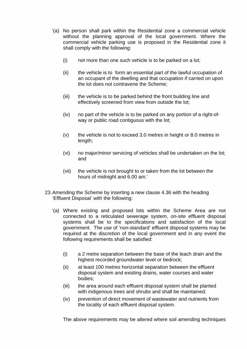
‘(a) No person shall park within the Residential zone a commercial vehicle
without the planning approval of the local government. Where the commercial vehicle parking use is proposed in the Residential zone it shall comply with the following:
(i) not more than one such vehicle is to be parked on a lot;
(ii) the vehicle is to form an essential part of the lawful occupation of
an occupant of the dwelling and that occupation if carried on upon the lot does not contravene the Scheme;
(iii) the vehicle is to be parked behind the front building line and
effectively screened from view from outside the lot;
(iv) no part of the vehicle is to be parked on any portion of a right-of-way or public road contiguous with the lot;
(v) the vehicle is not to exceed 3.0 metres in height or 8.0 metres in
length;
(vi) no major/minor servicing of vehicles shall be undertaken on the lot; and
(vii) the vehicle is not brought to or taken from the lot between the
hours of midnight and 6.00 am.’
23. Amending the Scheme by inserting a new clause 4.36 with the heading ‘Effluent Disposal’ with the following:
‘(a) Where existing and proposed lots within the Scheme Area are not
connected to a reticulated sewerage system, on-site effluent disposal systems shall be to the specifications and satisfaction of the local government. The use of ‘non-standard’ effluent disposal systems may be required at the discretion of the local government and in any event the following requirements shall be satisfied:
(i) a 2 metre separation between the base of the leach drain and the
highest recorded groundwater level or bedrock; (ii) at least 100 metres horizontal separation between the effluent
disposal system and existing drains, water courses and water bodies;
(iii) the area around each effluent disposal system shall be planted with indigenous trees and shrubs and shall be maintained;
(iv) prevention of direct movement of wastewater and nutrients from the locality of each effluent disposal system.
The above requirements may be altered where soil amending techniques

are introduced or alternatively the use of modified effluent disposal systems may be permitted in accordance with management guidelines prepared by the Local Government.
(b) Where on site effluent disposal systems are used, the system shall be
located within the prescribed building envelope or in another appropriate location specified by the Local Government.’
24. Amending the Scheme by inserting a new clause 4.37 with the heading
‘Light Overspill with the following:
‘(a) Floodlights, spotlights and all other forms of lighting shall be constructed, oriented and controlled so as not to:
(i) adversely impact on the amenity of any adjacent residents; or
(ii) Cause a traffic hazard in the adjacent road network.’
25. Amending the Scheme by replacing Clause 4.25 with the following:
‘(a) Where a caretaker’s dwelling use is proposed it shall comply with the
following:
(i) A caretaker's dwelling must be incidental to the predominant use of the site.
(ii) Only one caretaker's dwelling is permitted on each lot.
(iii) The total plot ratio area of a caretaker's dwelling is 100m²,
measured from the external face of walls excluding verandahs and carports.
(iv) Verandahs and carports may be permitted, but if enclosed will form
part of the total calculated floor area.
(v) The Local Government may consider the use of notifications on title to advise prospective purchasers of potential impacts from noise, dust, odour or amenity that may arise from the location of a caretaker's dwelling within the zone.
(vi) The Local Government will not consider applications for
caretakers' dwellings prior to the primary site activity being either approved or constructed.
(vii) Where simultaneous approval has been granted by the Local
Government for both a caretaker's dwelling and the main activity on the same lot, the main activity must be developed and
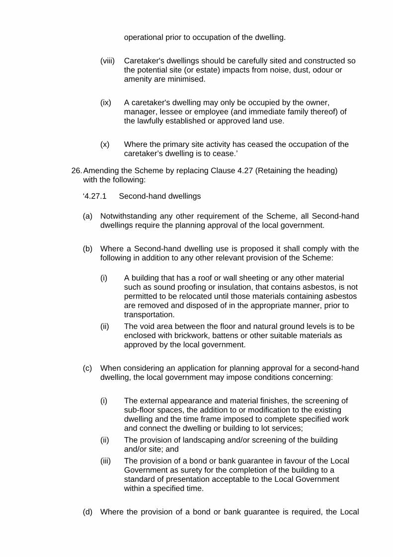
operational prior to occupation of the dwelling.
(viii) Caretaker's dwellings should be carefully sited and constructed so the potential site (or estate) impacts from noise, dust, odour or amenity are minimised.
(ix) A caretaker's dwelling may only be occupied by the owner,
manager, lessee or employee (and immediate family thereof) of the lawfully established or approved land use.
(x) Where the primary site activity has ceased the occupation of the
caretaker’s dwelling is to cease.’
26. Amending the Scheme by replacing Clause 4.27 (Retaining the heading) with the following:
‘4.27.1 Second-hand dwellings
(a) Notwithstanding any other requirement of the Scheme, all Second-hand
dwellings require the planning approval of the local government. (b) Where a Second-hand dwelling use is proposed it shall comply with the
following in addition to any other relevant provision of the Scheme:
(i) A building that has a roof or wall sheeting or any other material such as sound proofing or insulation, that contains asbestos, is not permitted to be relocated until those materials containing asbestos are removed and disposed of in the appropriate manner, prior to transportation.
(ii) The void area between the floor and natural ground levels is to be enclosed with brickwork, battens or other suitable materials as approved by the local government.
(c) When considering an application for planning approval for a second-hand
dwelling, the local government may impose conditions concerning:
(i) The external appearance and material finishes, the screening of sub-floor spaces, the addition to or modification to the existing dwelling and the time frame imposed to complete specified work and connect the dwelling or building to lot services;
(ii) The provision of landscaping and/or screening of the building and/or site; and
(iii) The provision of a bond or bank guarantee in favour of the Local Government as surety for the completion of the building to a standard of presentation acceptable to the Local Government within a specified time.
(d) Where the provision of a bond or bank guarantee is required, the Local
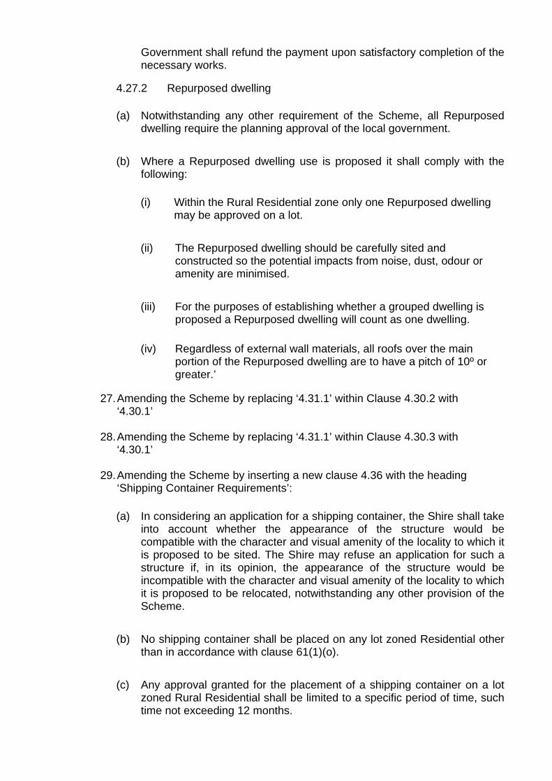
Government shall refund the payment upon satisfactory completion of the necessary works.
4.27.2 Repurposed dwelling
(a) Notwithstanding any other requirement of the Scheme, all Repurposed
dwelling require the planning approval of the local government. (b) Where a Repurposed dwelling use is proposed it shall comply with the
following:
(i) Within the Rural Residential zone only one Repurposed dwelling may be approved on a lot.
(ii) The Repurposed dwelling should be carefully sited and
constructed so the potential impacts from noise, dust, odour or amenity are minimised.
(iii) For the purposes of establishing whether a grouped dwelling is
proposed a Repurposed dwelling will count as one dwelling.
(iv) Regardless of external wall materials, all roofs over the main portion of the Repurposed dwelling are to have a pitch of 10º or greater.’
27. Amending the Scheme by replacing ‘4.31.1’ within Clause 4.30.2 with
‘4.30.1’
28. Amending the Scheme by replacing ‘4.31.1’ within Clause 4.30.3 with ‘4.30.1’
29. Amending the Scheme by inserting a new clause 4.36 with the heading ‘Shipping Container Requirements’:
(a) In considering an application for a shipping container, the Shire shall take
into account whether the appearance of the structure would be compatible with the character and visual amenity of the locality to which it is proposed to be sited. The Shire may refuse an application for such a structure if, in its opinion, the appearance of the structure would be incompatible with the character and visual amenity of the locality to which it is proposed to be relocated, notwithstanding any other provision of the Scheme.
(b) No shipping container shall be placed on any lot zoned Residential other
than in accordance with clause 61(1)(o). (c) Any approval granted for the placement of a shipping container on a lot
zoned Rural Residential shall be limited to a specific period of time, such time not exceeding 12 months.

(d) Not withstanding subclauses (b) and (c) where a shipping container is clad and has the addition of a pitched roof or is permanently screened from public view it may receive planning approval subject to subclause (a).
(e) A shipping container shall not be used for any form of accommodation
unless a component of an otherwise approved development. (f) A shipping container shall be adequately screened from the street and
shall not be stacked vertically unless otherwise approved.
(g) Where a shipping container has fallen into disrepair or become unsightly at the discretion of the local government, they shall be removed from the lot or suitably upgraded.
30. Amending the Scheme by inserting a new clause 4.36 with the heading
‘Outbuildings in the Residential and Rural Residential Zones’:
‘(a) Erection of an outbuilding on a Residential or Rural Residential zoned lot is not permitted unless development approval has already been issued for the erection of a single house, grouped dwelling or multiple dwelling on the lot.’
31. Amending the Scheme by inserting a new clause 4.24.4 as follows:
‘Within the Rural zone Telecommunications Infrastructure is exempt from the setbacks assigned in Schedule 2.’
32. Amending the Scheme by renumbering the second Clause ‘5.1.1’ with Clause ‘5.1.2’
33. Amending the Scheme by inserting a new clause within Table 12 –
Special control areas in the Scheme as follows:
Name of area Purpose Objectives Additional Provisions
SCA5 – Undeveloped Rural Area
The purpose of SCA 10 is to provide guidance for land use and development within the undeveloped rural zoned areas of the Shire.
To provide for mining activity, low key eco-tourism uses, environmental conservation and agricultural land uses.
1. Application Requirements
Despite any other provision of the Scheme planning approval is required for all development. Land uses are to be assessed as follows:
(a) As P uses
Telecommunications infrastructure
(b) As D uses
Mining Operations Agriculture – Extensive Agriculture – Intensive Animal Husbandry – intensive Holiday House

Repurposed dwelling Single House Second-hand dwelling Winery Workforce accommodation
(c) As I uses
Industry
(d) All other uses are to be
read as X uses in Table No. 4
2. Relevant Considerations
In addition to provisions of the Scheme, the local government in considering applications for rezoning, subdivision or planning approval in SCA 5 is to have due regard to –
(e) results of scientific
research conducted by Department of Biodiversity Conservation and Attractions or other relevant authority;
(f) guidelines of the
Environmental Protection Authority for protection of the environment including but not limited to maintenance of water quality;
(g) guidelines of the
Department of Water and Environmental Regulation for protection of wetlands and waterways including but not limited to maintenance of water quality; and
(h) the potential for adverse
environmental impacts and the management of such potential impacts.
and shall determine applications for planning approval accordingly.
3. Development Requirements
(a) Minimum lot sizes will be as per the Local Planning Strategy.
(b) Minimum setbacks to
development will be 20m to

all boundaries.
(c) The disposal of liquid and/or solid wastes shall be carried out with an effluent disposal system approved by the Local Government and the Health Department of Western Australia.
(d) A potable water supply
shall be provided to the satisfaction of the Local Government and in accordance with Clause 4.29 of the Scheme.
(e) Power will be generated on
site as there is no external service.
4. Referral of Applications
(a) Development application that require the clearing of native vegetation will be referred to the Department of Biodiversity Conservation and Attractions and the Department of Water and Environmental Regulation and the Local Government is to have due regard to recommendations and advice received from those authorities when determining applications.
34. Amending Clause 6.2 by inserting the following definition:
‘renewable energy facility’ means premises used to generate energy from a renewable energy source and includes any building or other structure used in, or in connection with, the generation of energy by a renewable resource. It does not include solar panels or a wind turbine located on a lot with a single house where the energy produced only supplies that house or private rural use or anemometers.’
35. Amending Clause 6.2 by inserting the following definition: ‘winery’ means premises used for the production of viticultural produce and associated sale of the produce;
36. Amending the Scheme by replacing ‘Ni’ within the front setback of Non-
residential uses in the Rural Townsite zone Schedule 2 with ‘Nil’.

37. Amending the Scheme by replacing ‘variable’ within the rear setback of
Non-residential uses in the Rural Townsite zone Schedule 2 with ‘Nil’.
38. Amending the Scheme by replacing ‘variable’ within the landscaping of Non-residential uses in the Rural Townsite zone Schedule 2 with ‘10’.
39. Amending the Scheme by replacing ‘variable’ within the rear setback of Non-residential uses in the Mixed Use zone Schedule 2 with ‘Nil’.
40. Amending the Scheme by replacing ‘variable’ within the landscaping of Non-residential uses in the Mixed Use zone Schedule 2 with ‘10’.
41. Amending the Scheme by replacing ‘Variable’ within the Plot Ratio of Tourism in Schedule 2 with ‘0.75’.
42. Amending the Scheme by replacing ‘Variable’ within the Rear Setback of Tourism in Schedule 2 with ‘Nil(i)’.
43. Amend the Scheme by inserting a new box for ‘Tourism’ in Schedule 2 as follows: ‘(i) Where development adjoin a Residential zone the minimum setback shall be at the discretion of the local government.’
44. Amending the Scheme by deleting the row ‘General Industry’ in Schedule 2.
45. 10. Amending the Scheme by replacing ‘Variable’ within the Plot Ratio of Light Industry in Schedule 2 with ‘0.6’.
46. Amending the Scheme by inserting a new Schedule 5 with the heading
‘Exempted Signage and Advertising’ as follows:
Land use and/or development
Exempted Signs Maximum Size
Dwellings One professional name-plate as appropriate
0.2m2
Home Occupation One advertisement describing the nature of the home occupation.
0.2m2
Places of Worship, Meeting Halls and Places of Public Assembly
One advertisement detailing the function and/or the activities of the institution concerned.
2.0m²
Shops, Showrooms and other uses appropriate to a Shopping Area
All advertisements affixed to the building below the top of the awning or, in the absence of an awning, below a line measured at 5 metres from the ground floor level of the building
Not Applicable
Industrial and Warehouse Premises
A maximum of four advertisements applied to or affixed to the walls of the building but not including signs which project above the eaves or the ridge of
Total area of such advertisements is not to exceed

the roof of the building, and excluding signs projecting from a building and excluding signs which are connected to a pole, wall, or other building.
15m2 or 20% of the elevation of the building whichever is the lesser.
A maximum of two freestanding advertisement signs not exceeding 5 metres in height above ground level.
Maximum permissible total area is not to exceed 10m² and individual advertisement signs are not to exceed 6m².
Showroom, racecourses, major racing tracks, sports stadia, major sporting grounds and complexes
All signs provided that, in each case, the advertisement is not designed to be visible from outside the complex or facility concerned either from adjacent private land or from public places and streets.
Not Applicable
Public Places and Reserves
Signs (illuminated and non-illuminated) relating to the functions of Government, a responsible authority or the local government including those of a promotional nature constructed or exhibited by, or on behalf of any such body, and
Not Applicable
Signs (illuminated and non-illuminated) required for the management or control of traffic on any public road, car park, cycleway, railway or waterway where such signs have been constructed or exhibited by or at the direction of Government, a responsible authority or the local government, and
Not Applicable
Signs (illuminated and non-illuminated) required to be exhibited by or pursuant to any statute or regulation or the like made pursuant to powers contained within a statute provided that any such advertisement is constructed and/or exhibited strictly in accordance with the requirements specified therein.
Not Applicable
Advertisements within Buildings
All advertisements placed or displayed within buildings, which cannot ordinarily be seen by a person outside of those buildings.
Not Applicable
All classes of buildings other than single family dwelling
One advertising sign containing the name, number and address of the building, the purpose for which the building is uses or the name and address if the managing agent thereof.
0.2m2
Temporary Signs Temporary Signs Exempted Signs Maximum Size

Building Construction Sites (signs displayed only for the duration of the construction) as follows: Dwellings One sign per street frontage containing
details of the project and the contractors undertaking the construction work.
2m²
Multiple dwellings, shops, commercial and industrial properties
One sign as for (a) above which may also include site security information.
5m²
Property transactions – Advertisement signs displayed for the duration of the period over which property transactions are offered and negotiated as follows: Dwellings One sign per street frontage for each
property relating to the sale, leasing or impending auction of the property at or upon which the sign is or the signs are displayed.
Each sign is not to exceed an area of 2m²
All other properties One sign as for (b) above. Each sign is not to exceed an area of 4m²
a. any sign which is the subject of an existing approval made prior to the date
of effect of this Policy;
b. any advertisement affixed to or painted on a shop window by the occupier of the shop and relating to the business carried on in the shop;
c. any sign within a building;
d. any building name sign on residential flats or home units which has a single line of letters not exceeding 300mm in height, fixed to the facade of the building;
e. any newspaper poster;
f. 1 freestanding sign (per building or business). The sign is to be placed or erected only to direct attention to a place, activity or event during the hours of that activity or event.
g. One (1) ‘rural producer sign’ displaying the name, street number and owners of the farm that does not exceed 4m2 in area.
h. All electoral signs erected up to four weeks before an election or referendum.
i. by the local government to advertise events or provide information of community interest.’
47. Amending the Scheme Map by showing all ‘General Industry’’ zoned land
as ‘Light Industry’ as depicted on the Amendment Map.
48. Amending the Scheme Map by showing SCA5 as depicted on the Amendment Map.

Current Zoning
Proposed Zoning
SHIRE OF RAVENSTHORPE LOCAL PLANNING SCHEME NO. 6
AMENDMENT NO. 1

Current Zoning
Proposed Zoning
SHIRE OF RAVENSTHORPE LOCAL PLANNING SCHEME NO. 6
AMENDMENT NO. 1

Current Zoning
Proposed Zoning
SHIRE OF RAVENSTHORPE LOCAL PLANNING SCHEME NO. 6
AMENDMENT NO. 1

Form 6A
COUNCIL ADOPTION This Standard Amendment was adopted by resolution of the Council of the Shire of Ravensthorpe at the Ordinary Meeting of the Council held on the day of , 20
..........................................................
SHIRE PRESIDENT
..............................................................
CHIEF EXECUTIVE OFFICER COUNCIL RESOLUTION TO ADVERTISE by resolution of the Council of the Shire of Ravensthorpe at the Ordinary Meeting of the Council held on the day of , 20 , proceed to advertise this Amendment.
..........................................................
SHIRE PRESIDENT
..............................................................
CHIEF EXECUTIVE OFFICER COUNCIL RECOMMENDATION This Amendment is recommended for approval by resolution of the Shire of Ravensthorpe at the Ordinary Meeting of the Council held on the day of , 20 and the Common Seal of the Shire of Esperance was hereunto affixed by the authority of a resolution of the Council in the presence of:
..........................................................
SHIRE PRESIDENT
.............................................................. CHIEF EXECUTIVE OFFICER
WAPC ENDORSEMENT (r.63)
........................................................ DELEGATED UNDER S.16 OF
THE P&D ACT 2005
DATE...............................................

Form 6A - Continued
APPROVAL GRANTED
......................................................... MINISTER FOR PLANNING
DATE.................................................

SHIRE OF RAVENSTHORPE LOCAL PLANNING POLICY MANUAL 1 | P a g e
TOWN LOCAL PLANNING SCHEME NO.56
LOCAL PLANNING POLICY MANUAL

SHIRE OF RAVENSTHORPE LOCAL PLANNING POLICY MANUAL
Document Control
Control Version DATE Officer Distribution Comment
A 14/04/14 CTP Shire of Ravensthorpe
First Draft for Comment
B 04/06/14 CTP Council Modified version for Council consideration
C 27/06/14 CTP Shire of Ravensthorpe
Adopted by Council for final approval 26/6/14
D 14/07/15 CTP Shire of Ravensthorpe
Advertising Signs policy revised and adopted for final approval by Council June 2015
E 24/11/16 CTP Shire of Ravensthorpe
Sea container policy revised and gained final approval at Council Nov 2016
F 24 /11/16 CTP Shire of Ravensthorpe
Draft “Developing in Bushfire Prone Areas” adopted for advertising
G 3/5/17 CTP Shire of Ravensthorpe
Final adoption of LPP15 “Developing in Bushfire Prone Areas”
H

SHIRE OF RAVENSTHORPE LOCAL PLANNING POLICY MANUAL
Contents
LOCAL PLANNING SCHEME NO.6 ........................................................................................ 1
LOCAL PLANNING POLICY MANUAL ................................................................................... 1
Document Control.................................................................................................................... 2
Contents ................................................................................................................................. 3
INTRODUCTION.................................................................................................................... 1
Background ................................................................................................................................................... 1
Objective ....................................................................................................................................................... 1
Approval Requirements............................................................................................................................... 1
Variations ...................................................................................................................................................... 1
Definitions and Interpretations ................................................................................................................... 2
LOCAL PLANNING POLICY NO.1 – Sportsfields – Advertising Signs ................ 3
Background ................................................................................................................................................... 3
Objectives ..................................................................................................................................................... 3
LOCAL PLANNING POLICY NO.1 - Requirements ................................................................................. 3
LOCAL PLANNING POLICY NO.2A – Advertising Signs ......................................... 5
Background ................................................................................................................................................... 5
Objectives ..................................................................................................................................................... 5
Definitions ..................................................................................................................................................... 5
LOCAL PLANNING POLICY NO.2A - Requirements ............................................................................... 7
LOCAL PLANNING POLICY NO.2B –Directional Signs ......................................... 16
Background ................................................................................................................................................. 16
Objectives ................................................................................................................................................... 16
Definitions ................................................................................................................................................... 16
LOCAL PLANNING POLICY NO.2B - Requirements ............................................................................. 17
LOCAL PLANNING POLICY NO.3 – Outbuildings .................................................... 20
Background ................................................................................................................................................. 20
Objectives ................................................................................................................................................... 21
LOCAL PLANNING POLICY NO.3 - Requirements ............................................................................... 21
Variations to the Policy .............................................................................................................................. 24
LOCAL PLANNING POLICY NO.4 –Housing .............................................................. 25
Background ................................................................................................................................................. 25

SHIRE OF RAVENSTHORPE LOCAL PLANNING POLICY MANUAL
Objectives ................................................................................................................................................... 25
LOCAL PLANNING POLICY NO.4 - Requirements ............................................................................... 25
LOCAL PLANNING POLICY NO.5 –Second-hand Dwellings ................................ 29
Background ................................................................................................................................................. 29
Objectives ................................................................................................................................................... 29
LOCAL PLANNING POLICY NO.5 - Requirements ............................................................................... 29
LOCAL PLANNING POLICY NO.6 – Shipping Containers ..................................... 32
Background ................................................................................................................................................. 32
Objectives ................................................................................................................................................... 32
LOCAL PLANNING POLICY NO.6 – Requirements .............................................................................. 32
LOCAL PLANNING POLICY NO.7 –Industrial Design Guidelines ...................... 36
Background ................................................................................................................................................. 36
Objectives ................................................................................................................................................... 37
LOCAL PLANNING POLICY NO.7 - Requirements ............................................................................... 37
LOCAL PLANNING POLICY NO.8 – Extractive Industry ....................................... 41
Background ................................................................................................................................................. 41
Objectives ................................................................................................................................................... 42
LOCAL PLANNING POLICY No.8 – Requirements ............................................................................... 42
LOCAL PLANNING POLICY No.10 – Public Open Space – 3-5 Lot Subdivision
.................................................................................................................................................. 47
Background ................................................................................................................................................. 47
Objectives ................................................................................................................................................... 48
LOCAL PLANNING POLICY No.10 – Requirements ............................................................................. 48
LOCAL PLANNING POLICY NO.11 – Alfresco Dining & Trading in Public
Places .................................................................................................................................... 49
Background ................................................................................................................................................. 49
Objectives ................................................................................................................................................... 49
LOCAL PLANNING POLICY NO.11 - Requirements ............................................................................. 50
LOCAL PLANNING POLICY NO.12 – Use of Rights of Way ................................. 52
Background ................................................................................................................................................. 52
Objectives ................................................................................................................................................... 52
LOCAL PLANNING POLICY NO.12 - Requirements ............................................................................. 53
LOCAL PLANNING POLICY NO.13 – Farm Forestry ............................................... 54
Background ................................................................................................................................................. 54

SHIRE OF RAVENSTHORPE LOCAL PLANNING POLICY MANUAL
Objectives ................................................................................................................................................... 54
Definitions ................................................................................................................................................... 55
LOCAL PLANNING POLICY NO.13 - Requirements ............................................................................. 55
LOCAL PLANNING POLICY NO.14 – Holiday Houses ............................................ 58
Background ................................................................................................................................................. 58
Objectives ................................................................................................................................................... 58
Definitions ................................................................................................................................................... 58
LOCAL PLANNING POLICY NO.14 - Requirements ............................................................................. 59
LOCAL PLANNING POLICY NO.15 –Development in Bushfire Prone Areas . 66
Background ................................................................................................................................................. 66
Purpose of the Policy ................................................................................................................................ 67
Definitions ................................................................................................................................................... 67
LOCAL PLANNING POLICY NO.15 - Requirements ............................................................................. 69
TOWN PLANNING SCHEME NO.5 .......................................................................................... 1

SHIRE OF RAVENSTHORPE LOCAL PLANNING POLICY MANUAL 1 | P a g e
INTRODUCTION
Background Clause 2.24 of the Deemed Provisions (set out in the Planning and Development (Local Planning Schemes) Regulations 2015 Schedule 2)the Shire of Ravensthorpe Town Planning Scheme No.5 gives the local government the ability to “prepare a Local Planning Policy in respect of any matter related to the planning and development of the Scheme area so as to apply –
a) generally or for a particular class or classes of matters; and b) throughout the Scheme Area or in one or more parts of the Scheme area.”
A Local Planning Policy does not bind Council or the Shire of Ravensthorpe in its decision making. However, the Shire of Ravensthorpe shall have due regard to the provisions of an applicable policy and the objectives which the policy is designed to achieve before making its determination on a planning matter.
The policies included in this Local Planning Policy Manual shall be read in conjunction with the requirements of the Shire of Ravensthorpe Town Local Planning Scheme No.5 6 and the Shire of Ravensthorpe Local Planning Strategy.
Objective This Local Planning Policy Manual has been prepared to guide applicants and staff in preparing and assessing subdivision and development proposals. It aims to consistently apply the objectives of the Shire of Ravensthorpe Town Local Planning Scheme No.5 6 in the assessment of all development proposals.
Approval Requirements Unless stated otherwise within this Policy Manual, all matters are subject to the exercise of discretion by Council in granting Planning Approval. In considering an Application for Planning Approval for each of the policy areas, Council shall have due regard to the specific Scheme clauses, clause 10.267 of the Deemed Provisions (set out in the Planning and Development (Local Planning Schemes) Regulations 2015 Schedule 2) the Shire of Ravensthorpe Town Planning Scheme No.5 and the objectives and requirements of the relevant policy.
Variations Any variations to a policy will require the applicant to demonstrate exceptional circumstances as to why the policy should be relaxed with the proposal being presented to an Ordinary Meeting of Council for determination. Assessment of the application will require consultation with adjoining and affected landowners.
Council will have regards to any matters set out in Clause 67 of the Deemed Provisions (set out in the Planning and Development (Local Planning Schemes) Regulations 2015 Schedule 2)10.2 and the objective of the specific policy when a proposal seeks to vary the provisions of the Local Planning Policy Manual.

SHIRE OF RAVENSTHORPE LOCAL PLANNING POLICY MANUAL
Definitions and Interpretations The below list outlines the definitions and interpretations used within this Policy Manual. Where a definition or interpretation is not listed, refer to the Shire of Ravensthorpe Town Local Planning Scheme No.56, Residential Design Codes of WA or Appendix B of the Model Scheme Text for information Clause 37 of the Deemed Provisions (set out in the Planning and Development (Local Planning Schemes) Regulations 2015 Schedule 2).
“Outbuilding” means;
a) An enclosed non habitable structure that is detached from any dwelling (as defined under the Residential Design Codes); or
b) Any Class 10A building under the Building Code of Australia (1996) Volume 2, which is not substantially connected to a dwelling. An open sided carport is not considered to be an outbuilding.
“Height” – is to be measured vertically from the natural ground level, as per the measuring criteria stipulated in the Residential Design Codes.
“Main building line” – means the distance from the front boundary of the property to existing buildings on the property, measured at a 90 degree angle from the closest point of the front boundary.
“Reflective materials” – means any material with the potential to cause glare , reflection or mirroring and shall include factory applied finishes such as zincalume and light colourbond colours such as white and off-white.
‘Rural Uses’ – means those land uses listed in the last section of the Town Local Planning Scheme No.5 6 Zoning Table & Use Classes and includes (but is not limited to) the use classes Agriculture Intensive, Animal Establishment, Rural Pursuit, Wayside Stall and Winery.
“Second Hand Dwelling” – means a building which has been used as a residential dwelling at any place other than on the lot upon which it is to be erected.
“Transportable Building” – means a prefabricated building that has been designed to be moved between sites, either being of a permanent or temporary nature.
"Visually Permeable" in reference to a wall, gate, door or fence that the vertical surface has:
continuous vertical or horizontal gaps of 50mm or greater width occupying not less than one third of the total surface area;
continuous vertical or horizontal gaps less than 50mm in width, occupying at least one half of the total surface area in aggregate; or
a surface offering equal or lesser obstruction to view;
as viewed directly from the street.
Advertising and Sign Interpretations
Definitions for Advertising and Signs are listed separately at Local Planning Policy 2.
Farm Forestry Interpretations
Definitions for Farm Forestry policy are listed separately at Local Planning Policy 13

SHIRE OF RAVENSTHORPE LOCAL PLANNING POLICY MANUAL
LOCAL PLANNING POLICY NO.1 – Sportsfields –
Advertising Signs
Background The Shire of Ravensthorpe Council adopted a policy on controlling advertisements in reserves to allow for advertisements in reserves to help offset the cost of maintaining reserves and to clarify what advertisements are acceptable.
Objectives To allow some forms of advertising signs on reserves.
LOCAL PLANNING POLICY NO.1 - Requirements
1. Exemptions from Planning Approval In addition to the works and development specified in Schedule 2, cl. 61 of Planning and Development (Local Planning Schemes) Regulations 2015 development approval of the local government is not required for the following works:
(as listed as Schedule 3 of Town Planning Scheme No.5): a. All signs at showgrounds, racecourses, major racing tracks, sports stadia,
major sporting grounds and complexes provided that, in each case, the advertisement is not visible from outside the complex or facility concerned either from other private land or from public places and streets.
b. Advertisement signs (illuminated and non-illuminated) relating to the functions of government a public authority or council of local government excluding those of a promotional nature constructed or exhibited by, or on behalf of any such body, and
c. Advertisement signs (illuminated and non-illuminated) required for the management or control of traffic on any public road, car park, cycleway, railway or waterway where such advertisement has been constructed or exhibited by or at the direction of a Government department, public authority or the council of a local government, and
d. Advertisement signs (illuminated and non-illuminated) required to be exhibited by or pursuant to any statute or regulation or the like made pursuant to powers contained within a Statute provided that any such advertisement is constructed and/or exhibited strictly in accordance with the requirements specified therein
2. General Requirements
In order to offset costs of maintaining reserves, Council shall, subject to the conditions hereunder, be receptive to proposals for corporate sponsorship for selective advertising on reserves:
a. Advertisements relating to, or promoting, tobacco/alcohol products shall not be permitted.
b. Clubs obtaining sponsorship for club activities shall be requested to obtain approval from Council before signs relating to such club sponsorship can be erected on sports fields, change rooms or other such structures including

SHIRE OF RAVENSTHORPE LOCAL PLANNING POLICY MANUAL
fences on sports fields. Signage, if approved, must face towards the playing surfaces only, of the sports fields.

SHIRE OF RAVENSTHORPE LOCAL PLANNING POLICY MANUAL
LOCAL PLANNING POLICY NO.2A – Advertising
Signs
Background Control of signage is in two parts; advertising signs on private land and directional signs on public land (road reserves & reserves). This policy addresses the signage requirements as they apply to private land. The Shire of Ravensthorpe Town Planning Scheme No.5 lists a number of signs which are exempt from Planning Approval, which are set out in Schedule 3 of the Scheme. All other signs on zoned land require Planning Approval to be issued by the Shire of Ravensthorpe and shall be subject to the requirements of this policy. Signage will be determined at Council’s discretion in accordance with this Policy.
Objectives To guide the design, materials and siting of advertising structures and signs in the Shire of Ravensthorpe and to provide a clear direction in respect to all sign types.
Definitions In this Policy, unless the context otherwise requires:
“advertisement” has the same meaning as "sign";
“advertising device” means any object on which words or numbers or figures are written, printed, affixed, illustrated or painted for the purpose of advertising any business, function, operation, event or undertaking or any product or thing and includes any vehicle or trailer or other similar stationery object placed or located so as to serve the purpose of advertising any business, function, event or undertaking or any product or thing;
“bill” means any material on which words, numbers or figures are written, placed, printed, illustrated or painted;
“business” includes the conduct of a profession, trade or occupation;
“depth” unless otherwise specifically stated, refers to the height of a sign, and not a three dimensional measurement. The word “depth” is used to differentiate between the lateral width of a sign and the height of the sign above the ground.
“development sign” means a sign erected on an area of land which has been approved for subdivision into a number of smaller lots, advertising the lots for sale but upon which no building development has taken place at the time of the approval of the sign;
“electoral sign” means a sign containing an advertisement relating to an election or to a referendum;
“exempt sign” means a sign referred to in Section 1 of the ‘Requirements’ section of this Policy;
“fascia sign” means a sign erected or displayed on the fascia of a building or the fascia of a verandah;

SHIRE OF RAVENSTHORPE LOCAL PLANNING POLICY MANUAL
“fly posting” means advertising by means of posters placed on fences, walls, trees and like structures;
“freestanding sign” means any sign not attached to a structure or permanently fixed to the ground or pavement and includes “A frame” or “Sandwich Board” signs consisting of two sign boards attached to each other at the top or elsewhere by hinges or other means;
“hoarding” means a detached or detachable structure other than a pylon sign that is erected for the sole purpose of displaying a sign or signs and includes a poster panel or an illuminated panel; but does not include a hoarding within the meaning of Section 377 of the Local Government (Miscellaneous Provisions) Act 1960;
“institutional sign” means a sign erected or placed on any land or building used for or in conjunction with a surgery, clinic, hospital, rest home, home for the aged or other institution or place of a similar nature;
“Panel / Fence Sign” – means an advertisement sign which is affixed to a panel or fence, but does not include a Pylon Sign, or any sign attached to a wall.
“planning consent” means the approval granted by Shire for the erection or display of a sign pursuant to the Town Planning Scheme;
“premises” means land and, unless the context otherwise requires, the buildings upon that land;
“projecting sign” means a sign the extends at right angles from a wall of a building;
“pylon sign” means a sign supported by one or more piers and not attached to a building and includes a detached sign framework supported by one or more piers to which sign infills may be added;
“remote sign” means a sign that is not located within or immediately adjacent to the business to which the sign relates, but does not include a portable sign.
“reserve” includes land vested in, or under the care, control and management of the Shire;
“roof sign” means a sign erected on or above the roof of a building;
“rural producer sign” means a sign erected on land zoned ‘General Agriculture’ under a Town Planning Scheme indicating the products grown, reared or produced on the property;
“sign” includes any advertising device or other sign type defined in this Local Planning Policy;
“sign infill” means a panel which can be fitted into a pylon sign framework;
“tourism sign” means a traffic sign with white letters and/or symbols on a brown background used to guide travellers to: natural features and approved heritage sites of interest to tourists; and tourist establishments. “verandah sign” an advertisement above, on or under a verandah, cantilever awning, cantilever verandah and balcony whether over a public thoroughfare or private land;
LOCAL PLANNING POLICY NO.2A - Requirements
1. Exemptions from Planning Approval:
In addition to the works and development specified in Schedule 2, cl. 61 of Planning and Development (Local Planning Schemes) Regulations 2015 development approval of the local government is not required for the following works:

SHIRE OF RAVENSTHORPE LOCAL PLANNING POLICY MANUAL
Signs exempt from Planning Approval are outlined in Schedule 3 – Exempted
Land use and/or development
Exempted Signs Maximum Size
Dwellings One professional name-plate as appropriate 0.2m2
Home Occupation One advertisement describing the nature of the home occupation.
0.2m2
Places of Worship, Meeting Halls and Places of Public Assembly
One advertisement detailing the function and/or the activities of the institution concerned.
2.0m²
Shops, Showrooms and other uses appropriate to a Shopping Area
All advertisements affixed to the building below the top of the awning or, in the absence of an awning, below a line measured at 5 metres from the ground floor level of the building
Not Applicable
Industrial and Warehouse Premises
A maximum of four advertisements applied to or affixed to the walls of the building but not including signs which project above the eaves or the ridge of the roof of the building, and excluding signs projecting from a building and excluding signs which are connected to a pole, wall, or other building.
Total area of such advertisements is not to exceed 15m2 or 20% of the elevation of the building whichever is the lesser.
A maximum of two freestanding advertisement signs not exceeding 5 metres in height above ground level.
Maximum permissible total area is not to exceed 10m² and individual advertisement signs are not to exceed 6m².
Showroom, racecourses, major racing tracks, sports stadia, major sporting grounds and complexes
All signs provided that, in each case, the advertisement is not designed to be visible from outside the complex or facility concerned either from adjacent private land or from public places and streets.
Not Applicable
Public Places and Reserves
Signs (illuminated and non-illuminated) relating to the functions of Government, a responsible authority or the local government including those of a promotional nature constructed or exhibited by, or on behalf of any such body, and
Not Applicable
Signs (illuminated and non-illuminated) required for the management or control of traffic on any public road, car park, cycleway,
Not Applicable

SHIRE OF RAVENSTHORPE LOCAL PLANNING POLICY MANUAL
railway or waterway where such signs have been constructed or exhibited by or at the direction of Government, a responsible authority or the local government, and
Signs (illuminated and non-illuminated) required to be exhibited by or pursuant to any statute or regulation or the like made pursuant to powers contained within a statute provided that any such advertisement is constructed and/or exhibited strictly in accordance with the requirements specified therein.
Not Applicable
Advertisements within Buildings
All advertisements placed or displayed within buildings, which cannot ordinarily be seen by a person outside of those buildings.
Not Applicable
All classes of buildings other than single family dwelling
One advertising sign containing the name, number and address of the building, the purpose for which the building is uses or the name and address if the managing agent thereof.
0.2m2
Temporary Signs
Temporary Signs Exempted Signs Maximum Size
Building Construction Sites (signs displayed only for the duration of the construction) as follows:
Dwellings One sign per street frontage containing details of the project and the contractors undertaking the construction work.
2m²
Multiple dwellings, shops, commercial and industrial properties
One sign as for (a) above which may also include site security information.
5m²
Property transactions – Advertisement signs displayed for the duration of the period over which property transactions are offered and negotiated as follows:
Dwellings One sign per street frontage for each property relating to the sale, leasing or impending auction of the property at or upon which the sign is or the signs are displayed.
Each sign is not to exceed an area of 2m²
All other properties One sign as for (b) above. Each sign is not to exceed an area of 4m²
a. any sign which is the subject of an existing approval made prior to the date of effect of this Policy;

SHIRE OF RAVENSTHORPE LOCAL PLANNING POLICY MANUAL
b. any advertisement affixed to or painted on a shop window by the occupier of the shop and relating to the business carried on in the shop;
c. any sign within a building;
d. any building name sign on residential flats or home units which has a single line of letters not exceeding 300mm in height, fixed to the facade of the building;
e. any newspaper poster;
f. 1 freestanding sign (per building or business). The sign is to be placed or erected only to direct attention to a place, activity or event during the hours of that activity or event.
g. One (1) ‘rural producer sign’ displaying the name, street number and owners of the farm that does not exceed 4m2 in area.
h. All electoral signs erected up to four weeks before an election or referendum.
i. Temporary signage approved by the local government to advertise events or provide information of community interest.
2. General Requirements
All signs and advertisements shall comply with the requirements set out in Table 1 of this policy and shall:
a. All sign applications shall stipulate the content of the sign with the application.
b. Not pose a threat to public safety or health and shall not have any sharp or pointed projections where it is less than 2.75m above natural ground level.
c. Be structurally sound and capable of withstanding any forces to which it would be reasonably subjected to without collapsing, deforming or moving.
d. Not extend beyond any property boundary of a lot, overhang or encroach onto any reserve, Council verge or road reserve.
e. Not be erected on land within a townsite unless it has a direct relationship with the business operated from the property or relevance to the premises on which they are located.
f. Not be in any position where it obstructs the view from a street or site lines for vehicles entering and departing the subject lot on which the sign is placed;
g. If illuminated:
i. use a low level of illumination and not cause a nuisance, by way of light spillage, to abutting sites;
ii. not comprise of flashing, pulsating, chasing or running lights; iii. not interfere with or be likely to be confused with traffic control signals; iv. have a minimum clearance of 2.75 metres from ground level.
h. Not undermine or conflict with the objective of this Policy;
i. Council reserves the right to refuse any sign in which the content of the advertisement:
i. could harm or cause detriment to the State;

SHIRE OF RAVENSTHORPE LOCAL PLANNING POLICY MANUAL
ii. make reference to a product which is unsafe, or is otherwise unsuitable to be referred to in the advertisement;
iii. contains confusing, misleading, political, offensive or objectionable information; and
iv. would breach any provision of the Trade Practices Act or any other State or Commonwealth legislation.

SHIRE OF RAVENSTHORPE LOCAL PLANNING POLICY MANUAL
Table 1 – Sign Specifications
Sign Type Max
imum
Hei
ght
Max
imum
Wid
th
Max
imum
Are
a
Min
imum
H
eigh
t of
Si
gn A
bove
NG
L
Max
imum
H
eigh
t of
Si
gn A
bove
NG
L
Max
imum
Pr
ojec
tion
from
Bui
ldin
g
Min
imum
Set
back
to
Fron
t Bou
ndar
y
Min
imum
Set
back
to
Side
Bou
ndar
y
Special Requirements
Remote Sign 4.5m2 3.0m i. The remote sign is to be associated with a business or community organisation based in the Shire of Ravensthorpe;
ii. It is erected within private property; iii. The owner or owners of the property in which the
remote sign is to be erected sign the Application for Planning Approval form;
iv. The sign is located not less than: 140m of another remote sign where the
speed limit of the adjacent road is 110km/h; 100m where the speed limit of the adjacent
road is 90km/h or less; v. It is to face the direction of approaching traffic. vi. It is located within 5km of a townsite, or as
otherwise determined by the local government taking into account the business location and the importance of the sign to providing information to the travelling public;
vii. It is not located within a gazetted townsite; viii. No more than two (2) remote signs per business
will be permitted; and ix. Planning approval for a 'remote sign' is valid for
five (5) years after which time a new application is required. Council may require the sign to be renewed at this time.
Note: all remote signs capable of being seen from highways also require separate approval of Main Roads WA in accordance with Main Roads WA own 'Roadside Advertising' policy.

SHIRE OF RAVENSTHORPE LOCAL PLANNING POLICY MANUAL
Sign Type Max
imum
Hei
ght
Max
imum
Wid
th
Max
imum
Are
a
Min
imum
H
eigh
t of
Si
gn A
bove
NG
L
Max
imum
H
eigh
t of
Si
gn A
bove
NG
L
Max
imum
Pr
ojec
tion
from
Bui
ldin
g
Min
imum
Set
back
to
Fron
t Bou
ndar
y
Min
imum
Set
back
to
Side
Bou
ndar
y
Special Requirements
Roof Sign - - 2.75m - - - i. General presumption against mounted roof signs, unless where the applicant can demonstrate: a. The sign can be incorporated within the
architectural design; and b. The form of advertising is determined to be
necessary for the business.
Verandah Sign
0.6m - - 2.75m - - Nil - i. One sign per tenancy/business; ii. 3m minimum separation to another verandah sign; iii. Be at right angles to the front street boundary, except
where located on a corner; iv. Verandah Signs attached to the facia of a verandah or
the like shall not project beyond the outer frame or surround of the facia.
Projecting Sign
- - 4m² 2.75m - 1.0m - 2.0m i. One sign per tenancy/business; ii. Do not project above the top of the wall to which they
are attached.

SHIRE OF RAVENSTHORPE LOCAL PLANNING POLICY MANUAL
Sign Type Max
imum
Hei
ght
Max
imum
Wid
th
Max
imum
Are
a
Min
imum
H
eigh
t of
Si
gn A
bove
NG
L
Max
imum
H
eigh
t of
Si
gn A
bove
NG
L
Max
imum
Pr
ojec
tion
from
Bui
ldin
g
Min
imum
Set
back
to
Fron
t Bou
ndar
y
Min
imum
Set
back
to
Side
Bou
ndar
y
Special Requirements
Pylon Sign 6.0m 4m² 2.75m ** (see iv)
6.0m - - 2.0m i. Exemptions: a. Where pylon signs are to be erected on a lot on
which a factory tenement building or small shops are erected or are to be erected the Shire may require all pylon signs to be incorporated into one sign in which case: all of the constituent or infill signs are of an
equal size; and one constituent or infill sign is provided for
each business, shop or unit on the lot ii. One sign per tenancy/business; iii. be supported on one or more piers or columns of
brick, stone, concrete, timber or steel of sufficient size and strength to support the sign under all conditions
iv. May be permitted at less than 2.75m above NGL where located in a landscaping strip or similar
Hoarding Sign - - - - - - - - Hoardings are not permitted within the Shire of Ravensthorpe.
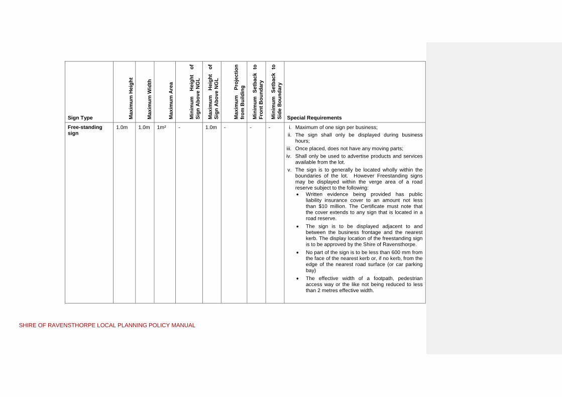
SHIRE OF RAVENSTHORPE LOCAL PLANNING POLICY MANUAL
Sign Type Max
imum
Hei
ght
Max
imum
Wid
th
Max
imum
Are
a
Min
imum
H
eigh
t of
Si
gn A
bove
NG
L
Max
imum
H
eigh
t of
Si
gn A
bove
NG
L
Max
imum
Pr
ojec
tion
from
Bui
ldin
g
Min
imum
Set
back
to
Fron
t Bou
ndar
y
Min
imum
Set
back
to
Side
Bou
ndar
y
Special Requirements
Free-standing sign
1.0m 1.0m 1m² - 1.0m - - - i. Maximum of one sign per business; ii. The sign shall only be displayed during business
hours; iii. Once placed, does not have any moving parts; iv. Shall only be used to advertise products and services
available from the lot. v. The sign is to generally be located wholly within the
boundaries of the lot. However Freestanding signs may be displayed within the verge area of a road reserve subject to the following: Written evidence being provided has public
liability insurance cover to an amount not less than $10 million. The Certificate must note that the cover extends to any sign that is located in a road reserve.
The sign is to be displayed adjacent to and between the business frontage and the nearest kerb. The display location of the freestanding sign is to be approved by the Shire of Ravensthorpe.
No part of the sign is to be less than 600 mm from the face of the nearest kerb or, if no kerb, from the edge of the nearest road surface (or car parking bay)
The effective width of a footpath, pedestrian access way or the like not being reduced to less than 2 metres effective width.

SHIRE OF RAVENSTHORPE LOCAL PLANNING POLICY MANUAL
Sign Type Max
imum
Hei
ght
Max
imum
Wid
th
Max
imum
Are
a
Min
imum
H
eigh
t of
Si
gn A
bove
NG
L
Max
imum
H
eigh
t of
Si
gn A
bove
NG
L
Max
imum
Pr
ojec
tion
from
Bui
ldin
g
Min
imum
Set
back
to
Fron
t Bou
ndar
y
Min
imum
Set
back
to
Side
Bou
ndar
y
Special Requirements
Panel/Fence Sign
- - 5m² 6.0m - - - i. Affixed to an existing panel or fence; ii. Are not erected between the existing building and the
front boundary of the lot; iii. Are not within 10m of an existing sign on a lot.
Development Sign
32m² - - - - - i. A development sign shall be removed from the site within 2 years from the date of the approval or when 80% of the lots in the subdivision (or stage of subdivision) have been sold, whichever is the sooner.
ii. Be displayed at the entrance to the subdivision and not remote from the lots being sold.
Rural Producer Sign
4m2
3.0m i. Maximum of one sign per property; ii. A rural business sign shall –
not indicate or display any matter other than for the purpose of advertising the sale of produce grown or made available on the land on which the sign is erected;
be erected within the boundaries on the land on which the produce offered for sale was grown or made or alternatively on the adjoining road verge if in the opinion of Council, existing vegetation would otherwise obscure the sign
Flags - - 4m² 2.75m 6.0m - - - i. Maximum of two flags permitted per business/tenancy; ii. The pole to which a flag is affixed is to be of sufficient
size and strength to support a flag; iii. No flag shall be permitted within 5m of another sign.

SHIRE OF RAVENSTHORPE LOCAL PLANNING POLICY MANUAL 16 | P a g e
LOCAL PLANNING POLICY NO.2B –Directional
Signs
Background Control of signage is in two parts; advertising signs on private land and directional signs on public land (road reserves & reserves). This policy addresses all signage requirements on public land. On public land directional signs have proliferated throughout the Shire of Ravensthorpe over a number of years. Many intersections, particularly in townsites, have too many signs and as a result all signage has become less effective. The primary purpose of directional signage is to assist the community to locate services and facilities. Road directional signage is not intended to be a form of advertising for any particular business or facility. This policy attempts to balance the need to keep signage in the road reserve to a minimum, while still allowing for the necessary directions to be given to the travelling public. Signage will be determined at Council’s discretion in accordance with this Policy.
Objectives To establish a consistent approach to the installation of directional signage without detriment to road safety, amenity or the rural landscape.
Definitions In this Policy, unless the context otherwise requires:
“advertisement” has the same meaning as "sign";
“Directional Signs” – are signs used at intersections to inform and advise road users about direction and distance to destinations on the route they are following. They include settlement, service and tourism signs.
“reserve” includes land vested in, or under the care, control and management of the Shire;
“service sign” a traffic sign with white letters and/or symbols on a blue background used to: guide travellers to services provided for their personal , automotive and travel needs, or indicate other facilities not normally shown on direction signs or tourist signs.
“settlement sign” are signs that inform road users of direction and distance to destinations.
“sign” includes any advertising device or other sign type defined in this Local Planning Policy;
“tourism sign” means a traffic sign with white letters and/or symbols on a brown background used to guide travellers to: natural features and approved heritage sites of interest to tourists; and tourist establishments.
Commented [r1]: Not a LPP – should be a Council Policy only

SHIRE OF RAVENSTHORPE LOCAL PLANNING POLICY MANUAL
LOCAL PLANNING POLICY NO.2B - Requirements
1. Exemptions from Planning Approval:
a. None apply.
2. General Requirements
In considering any application for approval for directional signage, the Council will have regard to the criteria below before a decision is made.
Permitted Signs a. Signage in road reserves will generally be limited to directional signage including
street, settlement, tourism and service signs.
b. No private advertising signs may be erected permanently on public land unless with good cause and in specific circumstances as agreed by the Council. Advertising signs and detailed public information should be located either on private property immediately adjacent to the business or service being advertised or within a Shire information bay with the prior approval of Council.
c. No temporary private advertising signs may be erected on public land without the approval of the Council.
d. Stand-alone signs are not generally supported but must be combined with the street name sign.
e. Directional signs are not generally permitted for home occupation, home business or holiday homes.
f. Directional signs will not generally be issued to individual businesses within the Rural Townsite, Mixed UseTown Centre, Light & Service Industry or General Industry zones (due to the location of multiple similar services in those zoned areas where the travelling public could expect to locate them).
g. All signs within a road reserve are governed by the Council and the Council reserves the right to remove unapproved signs with or without notice.
Type, Location and Number of Signs h. Permitted directional signs within road reserves, are to be fingerboard signs as
follows:
(i) Settlement Sign: (White on Green) signs that inform the road users of direction and distance to destinations.
(ii) Service Sign: (White on Blue) signs relating to community or not-for-profit facilities or businesses that are directly related to servicing visitors/tourists and locals.
(iii) Tourism Sign: (White on Brown) signs providing information on businesses, tourist attractions and historic sites.

SHIRE OF RAVENSTHORPE LOCAL PLANNING POLICY MANUAL
Examples of Directional Signs are:
SETTLEMENT SERVICE TOURISM
White on Green White on Blue White on Brown
HOPETOUN 50KM
RAVENSTHORPE
MUNGLINUP
TOWN CENTRE
Community Facilities
Hospital Police Station Religious buildings Halls, civic centres Post Office Sporting & recreational
grounds or facilities
Tourist Facilities / Business
Accommodation (including Caravan Parks & Camping Grounds)
Rural Business Visitor Information Centres
National Parks
Historic Buildings, Sites & Towns
State or Local Tourist/ Scenic drives
Scenic Look-outs
Commercial Tourist Attractions (e.g. Wineries with cellar door sales, animal farms etc)
i. Where more than one such directional sign is required for a particular street junction, then they shall be incorporated into a sign stack structure which will be erected by the Shire.
In any one sign stack the maximum number of fingerboards is five, not inclusive of the road name sign(s) at the top.
j. Hierarchy of signage in a stack from top to bottom is;
i) Street name ii) Settlement sign iii) Service sign (emergency services); iv) Service sign (community facilities); v) Tourist signage; then vi) Service sign (tourist facilities / business)
k. Each individual sign shall be a maximum width of 200mm and a maximum length of 1500mm. All signs in the one stack will be the same length.
l. For any one facility signage is generally permitted at two locations in rural areas and one location in urban areas.
Sign Content
m. Signs must contain a generic description and/or symbols rather than a specific business or trade name wherever possible.
n. Signs are to clearly indicate the nature of the attraction or service and comply with Australian Standards AS1742 Parts 5 &6, AS1744 and Main Roads WA guidelines with regards to size, colouring, lettering, symbols, fixing and installation.
Applications
o. Applications for all directional signs are required to be lodged with the Council on the appropriate form.

SHIRE OF RAVENSTHORPE LOCAL PLANNING POLICY MANUAL
p. Main Roads WA (MRWA) control specific roads within the Shire (South Coast Highway, Morgans Street and Hopetoun-Ravensthorpe Road). All applications for signs on these roads require the approval of both Council and MRWA.
q. The Council will proceed to have the signs manufactured and installed only after obtaining any comments necessary from referral agencies and approval has been granted on the form.
Maintenance
r. Unless otherwise stated, all signs are to be erected and maintained by the Shire at the expense of the applicant. Council will re-affix signs where possible but will not replace stolen or badly damaged signs. Where a sign requires to be replaced, a formal application is required and the relevant fees paid.
s. Council reserves the right to remove damaged, badly maintained or dangerous signs without notice.
Fees
t. Service and Directional Signs will be fabricated and erected on a cost recovery basis.

SHIRE OF RAVENSTHORPE LOCAL PLANNING POLICY MANUAL
LOCAL PLANNING POLICY NO.3 – Outbuildings
Background Outbuildings are Class 10a buildings under the Building Code of Australia (1996) which are not substantially connected to a dwelling.
Residents of the Shire of Ravensthorpe have different needs to those in metropolitan Perth, therefore this Policy recognises the need to vary the usual Residential Design Code recommendations by increasing outbuilding space (areas and heights) for garaging of vehicles, storage of boats, caravans and other items, domestic workshops, games rooms, studios, stables, etc. As a general rule people expect to be able to have larger outbuildings on larger lots.
It is important to note that outbuildings are ‘ancillary’ buildings and therefore must be constructed in conjunction with another permitted land use such as a house or a rural use such as a ‘rural pursuit’, animal establishment or intensive agriculture..
The Shire is also aware that in some instances outbuildings may result in problems including:
Use of outbuildings for unapproved commercial or industrial purposes, which may result in adverse noise, traffic, and visual impacts for neighbours and the locality. With the exception of those used for commercial farming purposes on rural lots, or approved home businesses, outbuildings may only be used for domestic purposes.
Illegal use of outbuildings as residences, which often incorporate inadequate health and building standards for human habitation.
Unlike most dwellings, outbuildings are usually very bland metal clad structures devoid of architectural features such as windows, verandas, etc. Construction of large and/or high sheds may have adverse impacts on visual character of streets and neighbourhoods, neighbours and scenic rural or coastal landscapes.
When outbuildings incorporate reflective materials such as zincalume and are sited in visually prominent locations there is greater potential for adverse impacts on the landscape, and in some instances reflection can cause a serious nuisance for surrounding/nearby residents. The Town Planning Scheme specifically has regard to all development “using ‘materials and colours … on the exterior surfaces of all buildings with the objective of buildings blending with the surrounding landscape and environment.”
As in many rural local governments there is often a desire to occupy a shed whilst building a house, particularly in the rural residential zones. This is not permitted by the Building Codes of Australia as an outbuilding is ‘non-habitable’ by definition. However, the Caravan and Camping Regulations 1997 allow for someone to camp on their property with the approval of the local government for up to 3 months and up to 12 months with approval from the Minister for Local Government. Camping in this fashion should be in a caravan and is only likely to be supported in the Rural Small Holding and Rural Conservation zones.

SHIRE OF RAVENSTHORPE LOCAL PLANNING POLICY MANUAL
Objectives The objectives of the policy are as follows:
a) To provide clear guidelines for the development of outbuildings in the Residential, Rural Townsite, Mixed Use Centre, Rural Small Holdings, Rural ConservationResidential and General AgricultureRural zones; and
b) To achieve a balance between providing for the various legitimate needs for outbuildings, and minimizing any adverse impacts outbuildings have on the neighbours, the streetscape, the amenity of the neighbourhood or locality and of the Shire as a whole.
LOCAL PLANNING POLICY NO.3 - Requirements
1. Exemptions from Planning Approval In addition to the works and development specified in Schedule 2, cl. 61 of Planning and Development (Local Planning Schemes) Regulations 2015 development approval of the local government is not required for the following works:
a. Where a proposed outbuilding complies with the requirements specified in sections 2 and 3 below, and Table 1 of this policy, Planning Approval is not required.
b. Pre-fabricated garden sheds and animal enclosures (such as kennels and aviaries) less than 9m² in aggregate area and less than 2.4 metres in height are exempt from the requirements of this policy.
2. General Requirements a. Outbuildings are required to comply with the requirements of the Residential Design
Codes of WA or as varied by the criteria set out in Table 1 below.
b. Outbuildings proposed for vacant Residential, Town Centre, Rural Small Holdings, Rural Conservation and General Agriculture zoned land require Council approval and will generally not be supported unless:
i) A Building Permit has been issued for a Single House; ii) The outbuilding is associated with an approved ‘Rural Use’; iii) In the Rural Small Holding and Rural ConservationResidential zones a written
undertaking is provided to build a house within 2 years of the outbuilding building permit being issued together with a bond of $5000. The bond is fully refundable upon substantial commencement of the house on the same property
c. Council will not permit residential habitation of a building approved as an outbuilding or shed on any land in the Shire of Ravensthorpe.
d. In the Residential, Town CentreMixed Use and , Rural ResidentialSmall Holdings, Rural Conservation and Town Centre zones zones, the use of non-reflective materials is required.
e. Ablutions are only permitted in an outbuilding where a house exists or has been substantially commenced on the same site.
f. Use of outbuildings for commercial or industrial purposes is not permitted. Use of an outbuilding for a home occupation or cottage industry is to be in accordance with Council’s Home Occupation, Home Business and Cottage Industry requirements.

SHIRE OF RAVENSTHORPE LOCAL PLANNING POLICY MANUAL

SHIRE OF RAVENSTHORPE LOCAL PLANNING POLICY MANUAL
Table 1 – Outbuilding Requirements
Zoning Maximum Wall Height
Maximum Ridge Height
Maximum floor area (aggregate)
Special Requirements
Residential 3.0metres 2.4m (where wall is < 1.0m from boundary
4.5metres 3.9m (where wall is < 1.0m from boundary
60 sq metres
Setbacks are to be in accordance with the Residential Design Codes of WA.
Any setback variation will be assessed on its individual merit and Council may consult with adjacent landowners.
Floor area is not to reduce the amount of open space required by Table 1 of the R-Codes.
Council will not support the construction of outbuilding/s in front of the main building line.
Town CentreRural Townsite and Mixed Use
3.0metres 2.4m (where wall is < 1.0m from boundary
4.5metres 3.9m (where wall is < 1.0m from boundary
60 sq metres
As per Residential requirements where the Town CentreRural Townsite or Mixed Use zoned property is used for residential purposes and constructed with an approved Single Dwelling or Grouped Dwelling.
General AgricultureRural
N/A N/A N/A Outbuildings are required to be setback in accordance with the following:
i. Front/Rear – 20metres ii. Side – 10metres
Planning approval is not required for outbuildings on General Agriculture zoned land unless:
i. The proposed outbuilding does not comply with the setback requirements listed above; and/or
ii. The lot does not have frontage to a constructed public road; and/or
iii. The lot, area or closely associated building/s are listed on the Municipal Inventory or State Register of Heritage Places.

SHIRE OF RAVENSTHORPE LOCAL PLANNING POLICY MANUAL
Rural Conservation &Rural Small Holdings zonesResidential
Lot Size Maximum Wall Height
Maximum Ridge Height
Maximum floor area (aggregate)
Special Requirements
< 2ha 3.84.5metres 45.5metres 150 200 sq metres
Outbuildings proposed in the Rural Small Holdings and Rural ConservationResidential zones are is to be in accordance with the requirements set out in Clause 4.8.315 and Schedules 9 & 102 of the Scheme.
2ha – 5ha 3.84.5metres 4.56metres 200 250 sq metres
< 5ha 3.84.5metres 4.56metres 250 sq metres
Variations to the Policy Any variations to the policy will require the applicant to demonstrate exceptional circumstances as to why the policy should be relaxed with the proposal being presented to an Ordinary Meeting of Council for determination. Assessment of the application will require consultation with adjoining and affected landowners.
Council will have regard for matters such as;
1. The visibility of the proposed outbuilding(s) as viewed from a street, public space or neighbouring property;
2. The need for removal of any native vegetation or major trees;
3. Comments from adjacent affected neighbours/landowners;
4. Preservation of useable on site open space areas;
5. The ability for the outbuilding(s) to be screened by existing or proposed landscaping;
6. Whether support for the application will set an undesirable precedent for similar sized surrounding lots;
7. The impact of the development on streetscape and the character of the area;
9. The objectives of the zone;
10. All relevant general matters as set out in Clause 67 of the Deemed Provisions (set out in the Planning and Development (Local Planning Schemes) Regulations 2015 Schedule 2)10.2 of the Scheme; and
11. Any other matter considered relevant by the Council.

SHIRE OF RAVENSTHORPE LOCAL PLANNING POLICY MANUAL
LOCAL PLANNING POLICY NO.4 –Housing
Background The Shire of Ravensthorpe has had separate policies in the past for governing the development of houses in the Hopetoun Residential Development Area (also known as Maryanne Waters), the Rural Small holding and Rural Conservation zones and a separate policy on the ‘Appearance of Dwellings’ There was considerable repetition in these policies, this policy unifies and replaces these previous policies.
Development of Single Houses is to comply with the requirements of Town Local Planning Scheme No.56 and in the ‘Residential’ zone, the Residential Design Codes of WA (R-Codes).
This Policy compliments the existing Scheme provisions and varies the ‘deemed-to-comply’ provisions of the R-Codes to the extent stated in this Policy as a ‘regional variation’ as permitted by clause 7.3 of the R-Codes.
This policy refers to the development of ‘Single Houses’, ‘Grouped Dwellings’ and ‘Multiple Dwellings’ in the Residential, Town CentreRural Townsite, Mixed Use, Rural Small Holding, Rural Conservation Residential and General Agriculture Rural zones.
Objectives The objectives of the policy are as follows:
a) To provide clear design guidelines for the development of housing in the Residential, Rural Townsite, Mixed UseTown Centre, Rural ResidentialSmall Holdings, Rural Conservation and General Agriculture zonesRural that complement the requirements of the Scheme and where applicable the R-Codes and
b) To provide design guidelines for housing in the Shire that establishes the standards expected of all residential development.
LOCAL PLANNING POLICY NO.4 - Requirements
1. Exemptions from Planning Approval a. Where a proposed Single House (including any extension) complies with the
requirements of the Residential Design Codes of Western Australia and the requirements specified in this policy, Planning Approval is not required. (Note: This exemption is provided by Clause 61.(c) and (d) of Schedule 2 of the Planning and Development (Local Planning Schemes) Regulations 2015)
2. General Requirements
a. Single Houses, Grouped Dwellings and Multiple Dwellings are required to comply with the requirements of the Residential Design Codes of WA (Where they apply) or as varied by the criteria set out in the clauses and Table 1 “Housing Requirements” below.
b. Split-coded areas i) With the exception of the minimum lot size, all the requirements of the higher
density coding shall apply to development on land zoned R10/20, R10/25 and R10/30.
ii) All development above the R10 density is required to connect to the reticulated sewerage system ‘

SHIRE OF RAVENSTHORPE LOCAL PLANNING POLICY MANUAL
c. Sheds and temporary accommodation units such as dongas are not permitted for
use as dwellings unless specifically approved as a ‘Repurposed Dwelling’..
d. All houses are to provide verandahs, porticos, porches or other architectural relief on the elevations that are viewed from the street with a minimum length of 25% of the front façade of the house.
e. Rural Small Holding & Rural ConservationResidential zone specific requirements i) Where a building envelope is shown on a Subdivision Guide Plan it may be
varied on application to the Council and the new building envelope location assessed against: The objective of the zone; Protection of landscape values; Impact on views from neighbouring properties; and Fire management requirements impacting remnant vegetation.
ii) Ancillary accommodation is to meet the following criteria: Solid panel fencing permitted around private areas of house and
immediate yard but within the building envelope. Fence between house and street is to be visually permeable.
f. Ancillary Accommodation requirements i) Ancillary accommodation is to meet the following criteria (within the Residential,
Rural Townsite and Mixed use zones): The ancillary accommodation can be attached or independent from a single
dwelling located on the same lot; The ancillary dwelling is a maximum of 80m² in floor area, excluding verandahs,
patios, carports and similar non-enclosed areas; and Materials and colours used on external walls and roof complement the main
dwelling. ii) Ancillary accommodation is to meet the following criteria (within Rural Residential
and Rural zones): The ancillary dwelling is a maximum of 80m² in floor area, excluding verandahs,
patios, carports and similar non-enclosed areas; and At least one parking bay is to be provided. Where an ‘Ancillary Accommodation’ unit exceeds the floor area stated in the first
dot point of Clause F.ii), a variation of up to 25% many be permitted subject to the advertising requirements of Clause 64 of Schedule 2 of the Planning and
Development (Local Planning Schemes) Regulations 2015.

SHIRE OF RAVENSTHORPE LOCAL PLANNING POLICY MANUAL 27 | P a g e
Table 1 Housing Requirements
Policy Requirement Residential zone Hopetoun Residential Development Area**
Town CentreRural Townsite and Mixed Use zones
Rural Small Holding & Rural ConservationResidential zones
General AgricultureRural zone
Location of Housing
As per R-Codes As per R-Codes As caretakers accommodation above or to the rear of commercial development that fronts the primary street. Refer clause 4.8.525 of the Scheme
As per specific zone requirements, either setback from boundaries or located within a building envelope.
Front/Rear setback – 20metres Side setback – 10metres
Reflective materials Roof only; at discretion of CouncilLocal Government; Care must be taken to avoid glare nuisance to neighbouring residences and passing traffic.
Roof only; at discretion of CouncilLocal Government; Care must be taken to avoid glare nuisance to neighbouring residences and passing traffic.
Roof only; at discretion of CouncilLocal Government; Care must be taken to avoid glare nuisance to neighbouring residences and passing traffic.
Not permitted Permitted
Minimum internal floor area
- 140m2 - - -
Front fence As per R-Codes Front fencing discouraged, use of hedges and landscaping acceptable; Maximum height of 1.2m in front of building line and must be visually permeable; and Fibro cement fencing is not permitted
Front fencing discouraged, where provided a maximum height of 1.2m in front of building line and the fence must be visually permeable.
Where permitted by the Scheme 5-strand ‘ring-lock’ type fencing. Barbed wire not permitted Solid panel fencing not permitted
‘Standard fence’ is post and strand fence.
Side & Rear ‘Standard fence’ is 1.8m high
‘Standard fence’ is 1.8m high Max height of 1.8m except where land is retained then max height of fence is 1.5m; No fibro cement fences, colourbond minimum standard
‘Standard fence’ is 1.8m high Where permitted by the Scheme 5-strand ‘ringlock’ type fencing. Barbed wire not permitted Solid panel fencing not permitted
‘Standard fence’ is post and strand fence.
Carparking, Garages and Carports
As per R-Codes Garages & carports to be constructed of same materials and under the same roof as main residence. Discretion applies to carports which may be located as close as possible to the dwelling and express architectural sympathy with main dwelling. Garages to be setback behind front building line of the dwelling.
As per R-Codes Gravel hardstand area required for the house. Garages and carports attached to the house are to be constructed of same materials.
-
Driveways & carparking
As per R-Codes Driveways to be completed concurrently with the dwelling. Maximum 1 driveway per dwelling.
As per R-Codes & Scheme requirements
Minimum width 3.0m Maximum width 5.0m Maximum 1 driveway per dwelling. Located to minimise noise and dust on neighbouring properties
-
Landscaping As per R-Codes Retention of existing vegetation on the site is to be included as part of any landscaping requirement.
As per R-Codes House and driveway location is to minimise the removal of existing remnant vegetation
-
** Plan of the Hopetoun Residential Development Area is appended to this Policy.

SHIRE OF RAVENSTHORPE LOCAL PLANNING POLICY MANUAL

SHIRE OF RAVENSTHORPE LOCAL PLANNING POLICY MANUAL
LOCAL PLANNING POLICY NO.5 –Second-hand
Dwellings
Background The Shire of Ravensthorpe Town Local Planning Scheme No.56 lists a second-hand dwelling as a discretionary land use in the Residential, Rural Townsite, Mixed Use, Rural General Agriculture, Rural Conservation and Rural ResidentialSmall Holding zones but does not list any specific development requirements for second hand dwellings.
The Residential Design Codes of Western Australia outline provisions relating to the appearance of a retained dwelling, but do not specifically outline provisions relating to a second hand dwelling being used as a new building on a property.
The Shire is aware that although the use of second hand dwellings is sometimes a more cost effective option, the use of second hand dwellings can sometimes cause an undesired impact on the streetscape and amenity where that dwelling is not of an appropriate standard or not updated appropriately to blend in with the property and the surrounding context.
Objectives The objectives of the policy are as follows:
a) To provide clear guidelines for the use of second hand dwellings in the Residential, General AgricultureRural Residential , Rural Conservation and Rural Residential Small Holding zones; and
b) To achieve a balance between providing for the various legitimate needs of residents to utilise second hand dwellings as a cost effective housing solution, whilst minimizing any negative impacts on the neighbours, the streetscape, the amenity of the neighbourhood or locality and of the Shire as a whole.
LOCAL PLANNING POLICY NO.5 - Requirements
1. Exemptions from Planning Approval
a. Where a transportable building is new (from factory) it is exempt from the requirements of this policy and is to be processed as a single dwelling in accordance with the requirements of the Scheme.
b. Sea and sShipping containers which are addressed through a separate policy of Council.
2. General Requirements
a. Planning approval is required for a second hand dwelling on a property within the Shire of Ravensthorpe.
b. Upon receiving an application for Planning Approval, Council may seek the views of adjacent neighbours.
b.c. Compliance with Clause 4.27 of Local Planning Scheme No. 6
c.d. Where a second hand dwelling is approved, a $10,000 bond is to be lodged with the Shire of Ravensthorpe as a condition of Planning Approval. The bond will be held until such time as all conditions of the Planning Approval and Building Permit have been complied with.

SHIRE OF RAVENSTHORPE LOCAL PLANNING POLICY MANUAL
d.e. Council needs to be satisfied that the external appearance of a second hand building is equivalent to that of a new dwelling or that its appearance is not discernible from existing development in the street.
e.f. Where a second hand dwelling contains asbestos it is to be removed prior to transportation
f.g. The following Minimum Dwelling Standard applies:
i) A minimum gross floor area of 50m²; ii) At least one (1) bedroom separate from the other rooms in the dwelling; iii) A lounge, meals and kitchen area (may be open plan); and iv) A separate bathroom and laundry.
g.h. Temporary accommodation units such as ‘Dongas’ are not permitted to be used as dwellings unless approved as a ‘Repurposed Dwelling’.
h.i. In determining applications, Council will have regard for; i) The age of the building and whether the external appearance shows
obvious signs of aging or disrepair (e.g. rust, faded paintwork or damage); ii) The street appeal of the front façade and any architectural features (e.g.
verandahs, windows with surveillance to the street); iii) Site improvements which have potential to result in street appeal through;
Construction of quality front fencing such as pickets or brick piers with open infill.
Landscaping and replacing substandard boundary fencing. Provision of coloured concrete or brick paved driveways.
i.j. Council will require all works for the re-erection of the second hand dwelling on a property to be completed within six (6) months of Planning Approval being issued. Those works include:
i. The house being transported and stumped, joined, all walls, doors and openings being in working order and all external surfaces repainted, re-clad or rendered to the satisfaction of the Shire of Ravensthorpe;
ii. Replacing or professionally recoating roof sheeting; iii. Replacing/repairing and painting gutters and downpipes; iv. Concealing or removal of plumbing fittings, meter boxes and other
utilities visible from a street or public place; v. Modifying, upgrading or replacing older steel or wood framed windows vi. All septic tanks, drains and plumbing being completed; vii. The site being cleared of any debris associated with the improvement
of the second hand dwelling; viii. Landscaping of the area between the street and building; ix. Providing a verandah, portico, porch or other architectural relief on the
elevations that are viewed from the street; and x. The second hand dwelling complying with the requirements of the
Building Code of Australia 1996 Volume 2.
j.k. Where a second hand dwelling is stumped, Council may require the installation of a verandah, porch, decking or similar to improve the look of permanence of a second hand dwelling.

SHIRE OF RAVENSTHORPE LOCAL PLANNING POLICY MANUAL
k.l. All applications for Planning Approval and the issue of a Building Permit for a second hand dwelling require the following details to be submitted to the Shire of Ravensthorpe:
i. Photographs showing each elevation of the second hand dwelling in situ prior to removal to the proposed location;
ii. Floor plans, elevations, cross section, site plan and specifications; and iii. A practicing structural engineer’s certificate stating the design of the
dwelling is suitable for transportation and re-erection.
Where these details are not provided, the Shire of Ravensthorpe may refuse to process an application for Planning Approval or the issue of a Building Permit.

SHIRE OF RAVENSTHORPE LOCAL PLANNING POLICY MANUAL
LOCAL PLANNING POLICY NO.6 – Sea Shipping
Containers
Background In recent years there has been an increased use of sea shipping containers for storage purposes within the Shire of Ravensthorpe. Sea Shipping containers provide a cheap and secure way of storing goods, but have the potential to affect the amenity of an area, given their industrial design and often poor location and maintenance.
Objectives The objectives of this policy are as follows:
a) To establish clear guidelines for the placement of sea containers used for storage purposes within the Shire;
b) To ensure that any sea shipping container does not detract from an existing (or reasonably desired) streetscape; and
c) To achieve a balance between providing the legitimate need for sea shipping containers as an affordable and secure storage option, and minimizing any impact on neighbours, streetscape, the amenity of the neighbourhood or locality and of the Shire as a whole.
LOCAL PLANNING POLICY NO.6 – Requirements
1. Exemptions from Planning Approval
In addition to the works and development specified in Schedule 2, cl. 61 of Planning and Development (Local Planning Schemes) Regulations 2015 development approval of the local government is not required for the following works:
b. c. Up to three (3) sea shipping containers does not require Planning Approval
when located on a property zoned ‘General Agriculture’Rural’ by the Scheme, provided they meet with the General Requirements set out below.
d. Sea Shipping container/s fully enclosed within a building does not require Planning Approval.
e. Sea Shipping container/s placed temporarily on the property for the purposes of furniture and/or goods removal or delivery do not require Planning Approval where they are located on a property for twenty eight (28) days or less.
f. In all zones a sea shipping container may be placed on a property temporarily, for a period of up to 12 months, for the storage of materials used to construct an approved dwelling or building.
g. Where a sea shipping container is proposed to be modified for a dwelling or commercial building, it will be required to be assessed against the requirements of Local Planning Policy No.3 and is to be modified to meet the requirements of the Building Codes of Australia (1996) Volume 2. Once a sea container is modified, it is no longer considered a sea container for the purposes of this policy.

SHIRE OF RAVENSTHORPE LOCAL PLANNING POLICY MANUAL
2. General Requirements
a. Shipping Sea container/s are to comply with the criteria set out in Table 1 of this policy.
b. Shipping Sea container/s are to be suitably screened and/or fenced from the road frontage, public space and neighbouring properties. Where a shipping sea container has high visibility from a public space, the installation of screening to a minimum height equal to that of the shippingsea container may be required.
c. ShippingSea container/s shall not be located over on-site effluent disposal infrastructure or other utilities and shall be located on a flat, compacted area with adequate foundations in accordance with the Building Code of Australia.
d. ShippingSea container/s shall be adequately ventilated, in good repair and painted a uniform colour to complement the building to which it is ancillary.
e. In all zones a shippingsea container will not be permitted on vacant land unless for the purposes of storage for construction purposes as outlined in 1d.
3. Special Application Requirements
a. Where it is proposed to use a shippingsea container, Council will require the applicant to submit photographs of the shippingsea container showing that it is in good condition.

SHIRE OF RAVENSTHORPE LOCAL PLANNING POLICY MANUAL
Table 1 – Sea Container Requirements
Zoning Setback Requirements Special Requirements
Residential No sea containers permitted.
Rural Townsite and Mixed UseTown Centre
The Sea Shipping Container shall not be located in front of the building setback and shall be screened from view of the street, including secondary streets and adjoining properties
A maximum of one (1) ShippingSea Container up to 12m in length per property. The ShippingSea Container is to be used in association with the approved commercial enterprise on the property. ShippingSea Containers for domestic storage associated with a residential use is not permitted. The ShippingSea Container shall be painted in a colour that is similar to or complementary to the colour of existing buildings on the property.
Rural Small Holding & Rural ConservationResidential
The ShippingSea Container to be located in accordance with the boundary setback and building envelope provisions for outbuildings for the particular property. The ShippingSea Container shall not be located in front of the building setback and shall be screened from view of the street, including secondary streets and adjoining properties. Council will not support the placement of a sea container in front of the main building line.
Only one shipping sea container, up to 6m in length is permitted per property. The shippingsea container is considered part of the permitted outbuilding floor space detailed in Local Planning Policy No.2 – Outbuildings. The shippingSea Container shall be painted in a colour that is similar to or complementary to the colour of existing buildings on the property. The shippingSea Container to be used for domestic storage purposes only.
Light Industry and Light & ServiceGeneral Industry zones
ShippingSea Containers are to be located behind the main building or in the case of a property without a main building, they are to be located towards the rear of the property
Where it is proposed to utilise multiple shipping sea containers, Planning Approval will be required. The temporary storage of containers associated with an approved transport or storage premises is exempt from the above requirements.
General AgricultureRural
On land zoned General AgriculturalRural, the setbacks are as follows:
a. Front/rear 20metres; b. Side 10metres.
Where more than three shippingsea containers are proposed, Planning Approval will be required.

SHIRE OF RAVENSTHORPE LOCAL PLANNING POLICY MANUAL

SHIRE OF RAVENSTHORPE LOCAL PLANNING POLICY MANUAL
LOCAL PLANNING POLICY NO.7 –Industrial Design
Guidelines
Background Town Local Planning Scheme No.56 (the Scheme) has two zones which are intended to accommodate industrial development; ‘Light & Service Industry’ and ‘General‘ Industry’. The objectives of these zones are as follows:
Light Industry
To provide for a range of industrial uses and service industries generally compatible with urban areas, that cannot be located in rural townsite and mixed use zones.
To ensure that where any development adjoins zoned or developed residential properties, the development is suitably set back, screened or otherwise treated so as not to detract from the residential amenity.
General Industry
To provide for a broad range of industrial, service and storage activities which, by the nature of their operations, should be isolated from residential and other sensitive land uses.
To accommodate industry that would not otherwise comply with the performance standards of light industry.
Seek to manage impacts such as noise, dust and odour within the zone.
Industry zone - to provide for manufacturing industry, the storage and distribution of goods and associated uses, which by the nature of their operations should be separated from residential areas.
Schedule 12 refers to an industrial area to the east of the Ravensthorpe townsite that never eventuated.
Table 1 – Development and Car Parking Standards’ for, Industry – Light & Service, Industry – General and ‘Showroom’ as follows:
Where Table 1 shows an asterisk that requirement is “to be determined by the local government’ in each particular case having due regard to the streetscape, amenity and merit of the proposal”. Whilst this is a site responsive approach, it provides no guidance to the Council, officers or community as to what is an acceptable standard of development.
It is important that the Shire’s industrial areas maintain a reasonable level amenity and that a level playing field is maintained for all landowners in these areas. Providing adequate parking for customers and staff within the lot boundaries to a consistent standard as well as a reasonable standard of landscaping in these zones is considered essential.
The development requirements need to be balanced with the need to encourage new business activity and what can be reasonably expected of and maintained by an industrial business operator.
The standard of development particularly within the front setback area of a development sets the standard for how an industrial area presents to the general public. This policy stipulates the minimum standards of development that the Shire of Ravensthorpe will accept for all new development in the Light & Service Industry and General Industry zones.
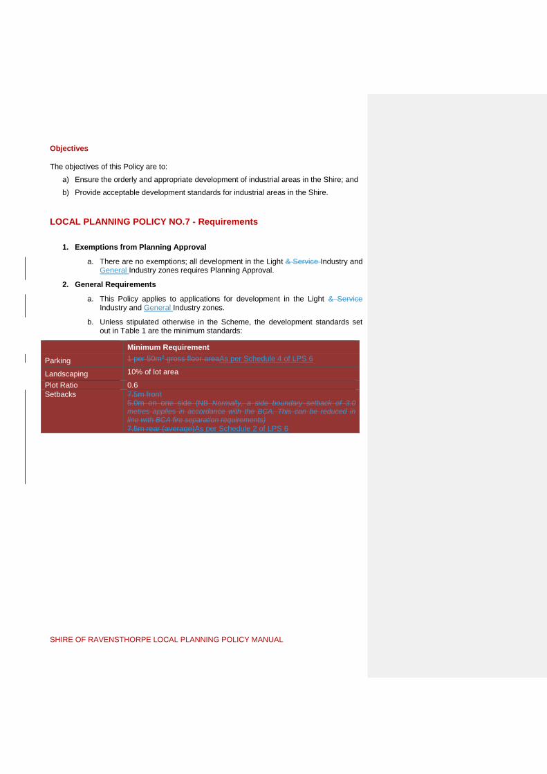
SHIRE OF RAVENSTHORPE LOCAL PLANNING POLICY MANUAL
Objectives The objectives of this Policy are to:
a) Ensure the orderly and appropriate development of industrial areas in the Shire; and
b) Provide acceptable development standards for industrial areas in the Shire.
LOCAL PLANNING POLICY NO.7 - Requirements
1. Exemptions from Planning Approval
a. There are no exemptions; all development in the Light & Service Industry and General Industry zones requires Planning Approval.
2. General Requirements
a. This Policy applies to applications for development in the Light & Service Industry and General Industry zones.
b. Unless stipulated otherwise in the Scheme, the development standards set out in Table 1 are the minimum standards:
Minimum Requirement
Parking 1 per 50m2 gross floor areaAs per Schedule 4 of LPS 6
Landscaping 10% of lot area
Plot Ratio 0.6 Setbacks 7.5m front
5.0m on one side (NB Normally, a side boundary setback of 3.0 metres applies in accordance with the BCA. This can be reduced in line with BCA fire separation requirements) 7.5m rear (average)As per Schedule 2 of LPS 6
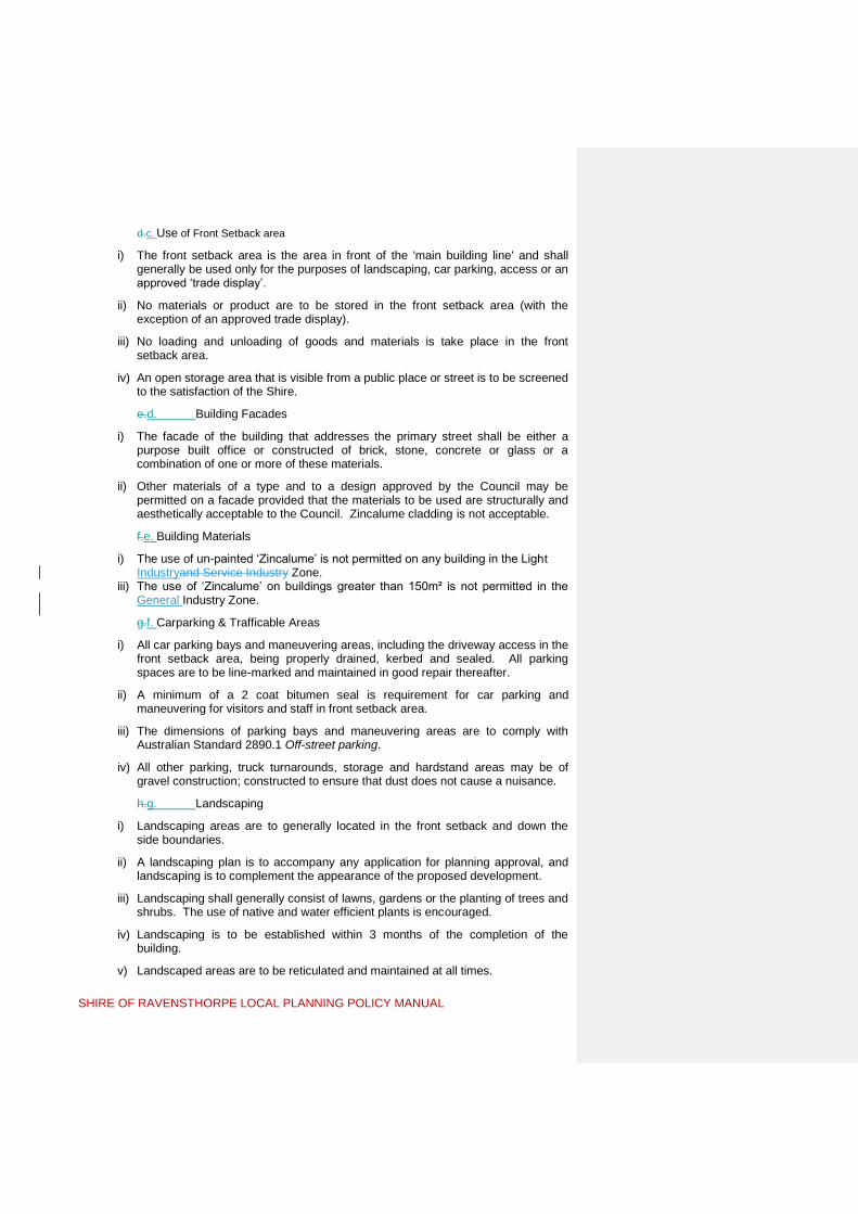
SHIRE OF RAVENSTHORPE LOCAL PLANNING POLICY MANUAL
d.c. Use of Front Setback area
i) The front setback area is the area in front of the 'main building line' and shall generally be used only for the purposes of landscaping, car parking, access or an approved ‘trade display’.
ii) No materials or product are to be stored in the front setback area (with the exception of an approved trade display).
iii) No loading and unloading of goods and materials is take place in the front setback area.
iv) An open storage area that is visible from a public place or street is to be screened to the satisfaction of the Shire.
e.d. Building Facades
i) The facade of the building that addresses the primary street shall be either a purpose built office or constructed of brick, stone, concrete or glass or a combination of one or more of these materials.
ii) Other materials of a type and to a design approved by the Council may be permitted on a facade provided that the materials to be used are structurally and aesthetically acceptable to the Council. Zincalume cladding is not acceptable.
f.e. Building Materials
i) The use of un-painted ‘Zincalume’ is not permitted on any building in the Light Industryand Service Industry Zone.
iii) The use of ‘Zincalume’ on buildings greater than 150m² is not permitted in the General Industry Zone.
g.f. Carparking & Trafficable Areas
i) All car parking bays and maneuvering areas, including the driveway access in the front setback area, being properly drained, kerbed and sealed. All parking spaces are to be line-marked and maintained in good repair thereafter.
ii) A minimum of a 2 coat bitumen seal is requirement for car parking and maneuvering for visitors and staff in front setback area.
iii) The dimensions of parking bays and maneuvering areas are to comply with Australian Standard 2890.1 Off-street parking.
iv) All other parking, truck turnarounds, storage and hardstand areas may be of gravel construction; constructed to ensure that dust does not cause a nuisance.
h.g. Landscaping
i) Landscaping areas are to generally located in the front setback and down the side boundaries.
ii) A landscaping plan is to accompany any application for planning approval, and landscaping is to complement the appearance of the proposed development.
iii) Landscaping shall generally consist of lawns, gardens or the planting of trees and shrubs. The use of native and water efficient plants is encouraged.
iv) Landscaping is to be established within 3 months of the completion of the building.
v) Landscaped areas are to be reticulated and maintained at all times.

SHIRE OF RAVENSTHORPE LOCAL PLANNING POLICY MANUAL
vi) With the approval of the Shire fifty (50) per cent of the landscaping requirement identified in the Scheme Text and this Policy may be met by landscaping the verge area, providing that reticulation is installed and on-going maintenance of the total road verge bordering the subject lot is undertaken. For corner lots, this credit will be eighty (80) per cent of the landscaping requirement identified in the Scheme Text where the whole of the verge is treated.
i.h. Stormwater
i) Stormwater is to be contained on site before discharged to road or district system.
ii) The development may require oil separators or nutrient stripping infrastructure (such as retention basins) at the discretion of the Shire.
iii) The use of rainwater tanks for storage and reuse on site is encouraged.
j.i. Fencing
i) Boundary fencing is permitted to a maximum of 2.1m.
ii) Fencing along the primary street frontage is to be visually permeable.
iii) The use of barbed wire is not permitted.
k.j. Use of Transportable Buildings
i) The use of transportable buildings (including second-hand buildings), such as offices and ablutions is permitted only with Council Planning Approval.
ii) Transportable buildings are to be painted and/or clad to complement other buildings on the property.
iii) Council may require modification of the roof line to ensure the building is made visually acceptable in the streetscape.

SHIRE OF RAVENSTHORPE LOCAL PLANNING POLICY MANUAL
LOCAL PLANNING POLICY NO.8 – Extractive
Industry
Background The Shire of Ravensthorpe Town Local Planning Scheme No.5 6 defines an extractive industry as follows:
“industry – extractive” means premises, other than premises used for mining operations, that are used for the extraction of basic raw materials including by means of ripping, blasting or dredging and may include facilities for any of the following purposes –
(a) the processing of raw materials including crushing, screening, washing, blending or grading;
(b) activities associated with the extraction of basic raw materials including wastewater treatment, storage, rehabilitation, loading, transportation, maintenance and administration;
“industry – extractive” means an industry which involves the extraction, quarrying or removal of sand, gravel, clay, hard rock, stone or similar materials from the land and includes the treatment and storage of those materials, or the manufacture of products from those materials on, or adjacent to, the land from which the materials are extracted, but does not include industry – mining;
Extractive industries can have a high impact on the surrounding road infrastructure, existing vegetation and amenity of surrounding landowners and will therefore be referred to the relevant government agencies during the assessment period for comment. These may include Main Roads WA, Department of Biodiversity Conservation and AttractionsDepartment of Parks and Wildlife, Department of Water and Environmental RegulationDepartment of Environmental Regulation, Department of Water, Department of Mines, Industry Regulation and Safety and Petroleum and Department of Primary Industries and Regional DevelopmentDepartment of Agriculture and Food WA depending upon the nature of the application.
Where existing remnant vegetation is proposed to be cleared the applicant may need to seek a Vegetation Clearing Permit from the Department of Water and Environmental Regulation Department of Environment Regulation in accordance with the Environmental Protection (Clearing of Native Vegetation) Regulations 2004.
Larger extractive industries may require registration or a license as a ‘prescribed premise’ from the Department of Water and Environmental Regulation Department of Environmental Regulation under Part V of the Environmental Protection Act 1986 (Environmental Protection Regulations, 1987, Schedule 1)
Finally, the Department of Mines, Industry Regulation and Safety Department of Mines and Petroleum (DMIRSP) have a separate role under the Mine Safety & Inspection Act 1994 to ensure the safety of extractive industries throughout the Shire. A separate approval and process is required with the DMIRSP including preparing a ‘Project Management Plan’. More information is available at http://www.dmp.wa.gov.au/Safety/Submitting-a-project-management-9184.aspx.http://www.dmp.wa.gov.au/14695.aspx.
Objectives The objectives of this policy are as follows:

SHIRE OF RAVENSTHORPE LOCAL PLANNING POLICY MANUAL
a) To assist Council in determining applications for extractive industries by providing general guidelines and outlining matters Council will have regard for in assessing applications.
b) To protect and maintain the existing landscape character, native vegetation, productive agricultural uses and general amenity of the Shire.
c) To set out standard conditions that will be considered by Council in their assessment of extractive industry applications.
d) To provide for appropriate ‘buffers’ between extractive industries and sensitive land uses.
LOCAL PLANNING POLICY No.8 – Requirements
1. Exemptions from Planning Approval
a. No exemptions are applicable to this policy.
2. General Requirements
a. The following setbacks will generally be applied to excavation areas/ pits; i) A minimum of 75 metres to any road or thoroughfare; ii) A minimum of 50 metres to any property boundary in a different
ownership; iii) A minimum of 50 metres to any water course or stand of remnant
vegetation.
b. Excavation areas/ pits are to be separated from the closest ‘sensitive land use’ on a different lot (usually a house) by the recommended generic buffer distance listed in Table 1 unless a site specific technical study is prepared.
c. Where an extractive industry proposes direct access to a sealed road and the projected number of vehicle movements from the site would justify such a requirement (as determined by Council), the Council may require crossover and vehicle access areas within 50 metres of the road to be constructed with a stable, impervious surface.
d. Those portions of public roads as are affected by the activities related to an extractive industry shall be maintained to a ‘pre-development’ standard acceptable to Council at the applicants cost. A road maintenance contribution and / or bond may be payable to Council prior to commencement of works to ensure roads are maintained to satisfactory standards. The contribution may be applied at the discretion of Council. Such upgrading contributions may be financial or in-kind and shall be calculated on a case-by-case basis.
e. An Environmental Management Plan is to be submitted addressing dieback controls, spread of noxious weeds, dust and noise is to be compiled in consultation with the Department of Biodiversity Conservation and Attractions Department of Parks and Wildlife and submitted to the Shire for separate written endorsement prior to commencement of any site work or an alternative time period agreed to in writing by the Shire.
f. A Rehabilitation Plan is to be submitted and approved by the Shire in writing. This plan is to address (but not be limited to) the following issues:
i) Restrict the area of open pit to 2 hectares. Larger pits may be considered for gravel extraction where the applicant can demonstrate that it will not

SHIRE OF RAVENSTHORPE LOCAL PLANNING POLICY MANUAL
have any detrimental impact on the environment or amenity of the area (by lodging a detailed environmental management plan).
ii) How the portions of land subject to extraction are to be rehabilitated (following each stage of extraction) to allow for future rural use and shall include;
Flattening the land; Spreading of stockpiled topsoil (capable of supporting seed and
plant re-growth); Forming stable battered banks not to be steeper than 1 in 5;
and/or And revegetation using native trees, shrubs and groundcovers/
undergrowth.
g. An extractive industry licence is valid for twelve (12) months from issue of the Planning Approval starting from the 1st July. It is renewable annually by the Shire subject to no complaints being received by the Shire.
h. Should Council be informed by the Permit Holder that renewal of the Approval is not required; Council will formally revoke the Approval. The operator is to ensure that the excavation is properly rehabilitated.
Table 1 – Generic buffers to sensitive land uses
Industry Description of Industry Buffer distance in meters
Clay extraction or processing
Mining, extraction or processing of clay
500-1000 depending on size.
Extractive Industry – hard rock
quarrying (including blasting), crushing and screening
1000
sand and limestone extraction
no grinding or milling works
300-500 depending on size
3. Special Application Requirements
a. Where a new extractive industry is proposed, or an existing industry is to be increased in size over what was originally approved, planning approval is required prior to the industry commencing or extending. Applicants need to lodge;
A completed planning application form to be signed by the owner of the land.
A detailed written submission explaining the application, and addressing the matters to be considered at part 3b of this policy (as per below).
Detailed, accurate and scaled plans.
b. In considering any application, Council will have regard for the following matters;
i) It is important that each application be examined on its individual merit having regard for the existing land uses, topography of the land, and its specific location.

SHIRE OF RAVENSTHORPE LOCAL PLANNING POLICY MANUAL
ii) Whether the site is in a visually significant location such as on a ridge, adjacent to the coast or an estuary, close to a national park or nature reserve, visible from a major road, tourist destination, scenic route or tourist route*1.
iii) Compatibility with adjoining land uses.
iv) Noise, dust and vibration abatement measures.
v) Proximity and buffers to wetlands and water courses.
vi) Whether the proposal includes clearing of significant remnant vegetation and the quality of vegetation.
vii) Drainage implications including surface and ground water impacts.
viii) Rehabilitation measures.
ix) Intended end use of the land and future planning for the area.
x) Prevention of spread of dieback or other disease.
xi) Environmental management and measures proposed to be undertaken by the proponent to address environmental issues.
xii) Whether the access roads proposed are suitable for the volume of traffic and type of heavy vehicles proposed.
xiii) Whether the site has access to major roads, and whether the existing roads to be used by trucks are in good condition.
xiv) The proposed road haulage route and whether the use of any state controlled roads are proposed.
xv) Size of trucks and number of truck movements.
xvi) Existence of other extractive industry or heavy haulage-associated use in the vicinity.
xvii) Details of the storage of fuel and flammable materials on the site;
xviii) The material to be excavated, including maximum depth of excavation, area to be open at any one time and expected pit life;
c. Council has discretion to advertise any application for extractive industry through letters to adjacent and nearby landowners, letters to relevant authorities, newspaper advertising and / or a sign on site.
Whilst the need for advertising can be determined on a ‘case by case’ basis, this Policy recommends that all ‘extractive industry’ applications be advertised due to potential impact on amenity and application of buffers.
Advertising will be for a minimum of 14 days in accordance with Clause 64 of Schedule 2 of the Planning and Development (Local Planning Schemes) Regulations 2015. 9.4 of the Scheme.
The application may also be referred to relevant authorities in accordance with Clause 10.1 of the Scheme66 of Schedule 2 of the Planning and Development (Local Planning Schemes) Regulations 2015. The types of authorities that Council may liaise with include (but are not limited to);
Environmental Protection Authority (EPA)
Department of Biodiversity Conservation and Attractions (DBCA) Department of Parks and Wildlife (DPAW)

SHIRE OF RAVENSTHORPE LOCAL PLANNING POLICY MANUAL
Department of Water and Environmental Regulation (DWER) Department of Water (DoW)
Main Roads (MRWA)
Western Power (WP)
Department of Indigenous AffairsPlanning, Lands and Heritage (DIADPLH).
Tourism WA
Any other authority Council considers relevant.
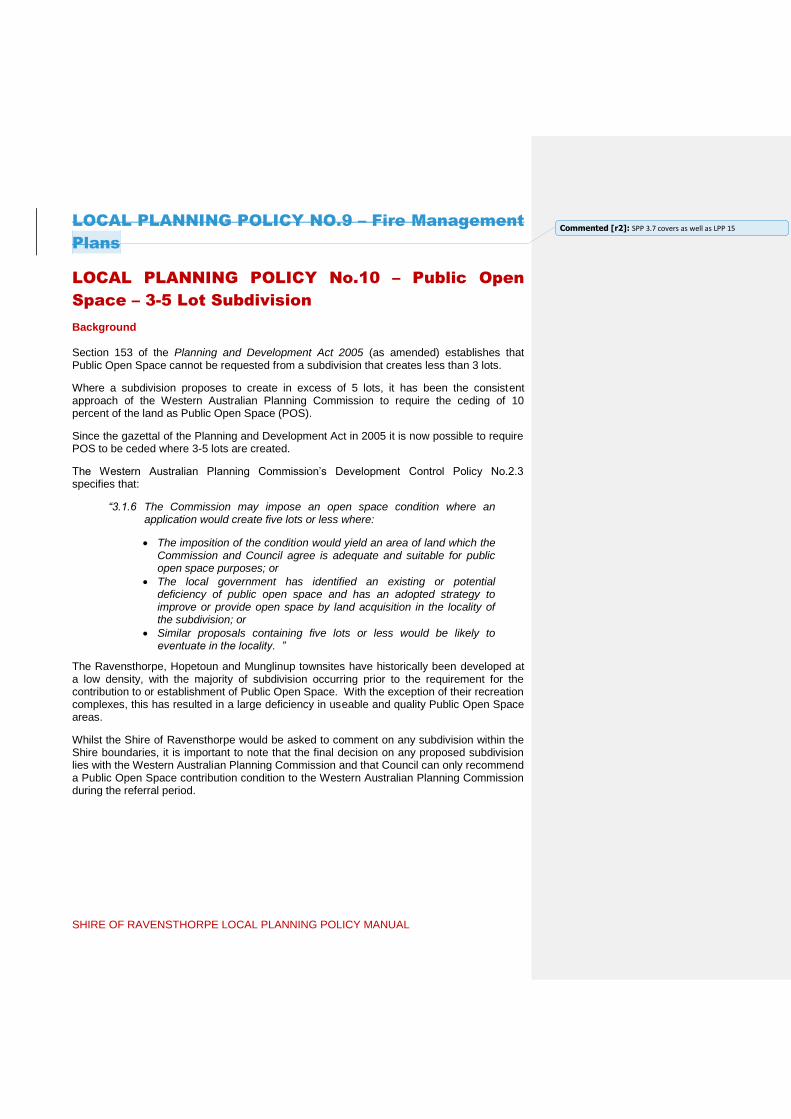
SHIRE OF RAVENSTHORPE LOCAL PLANNING POLICY MANUAL
LOCAL PLANNING POLICY NO.9 – Fire Management
Plans
LOCAL PLANNING POLICY No.10 – Public Open
Space – 3-5 Lot Subdivision
Background Section 153 of the Planning and Development Act 2005 (as amended) establishes that Public Open Space cannot be requested from a subdivision that creates less than 3 lots.
Where a subdivision proposes to create in excess of 5 lots, it has been the consistent approach of the Western Australian Planning Commission to require the ceding of 10 percent of the land as Public Open Space (POS).
Since the gazettal of the Planning and Development Act in 2005 it is now possible to require POS to be ceded where 3-5 lots are created.
The Western Australian Planning Commission’s Development Control Policy No.2.3 specifies that:
“3.1.6 The Commission may impose an open space condition where an application would create five lots or less where:
The imposition of the condition would yield an area of land which the Commission and Council agree is adequate and suitable for public open space purposes; or
The local government has identified an existing or potential deficiency of public open space and has an adopted strategy to improve or provide open space by land acquisition in the locality of the subdivision; or
Similar proposals containing five lots or less would be likely to eventuate in the locality. ”
The Ravensthorpe, Hopetoun and Munglinup townsites have historically been developed at a low density, with the majority of subdivision occurring prior to the requirement for the contribution to or establishment of Public Open Space. With the exception of their recreation complexes, this has resulted in a large deficiency in useable and quality Public Open Space areas.
Whilst the Shire of Ravensthorpe would be asked to comment on any subdivision within the Shire boundaries, it is important to note that the final decision on any proposed subdivision lies with the Western Australian Planning Commission and that Council can only recommend a Public Open Space contribution condition to the Western Australian Planning Commission during the referral period.
Commented [r2]: SPP 3.7 covers as well as LPP 15

SHIRE OF RAVENSTHORPE LOCAL PLANNING POLICY MANUAL
Objectives
The objectives of this policy are as follows:
a) To ensure that there is adequate provisions of Public Open Space within the townsites of the Shire of Ravensthorpe.
b) To ensure that Public Open Space owned and maintained by the Shire of Ravensthorpe is of a high quality for use; and
c) To provide suitable guidelines to Council where it should request a land or cash-in-lieu contribution to Public Open Space for subdivisions creating between 3 – 5 lots.
LOCAL PLANNING POLICY No.10 – Requirements
1. Exemptions from Public Open Space contribution:
a. This policy only applies to subdivision which creates 3-5 lots zoned ‘Residential’ by the Shire of Ravensthorpe Town Local Planning Scheme No.56.
2. General Requirements:
a. The following contribution of land or cash-in-lieu shall be applied: i. 5 percent where a proposal creates three (3) ‘Residential’ zoned lots; ii. 7.5 percent where a proposal creates four (4) ‘Residential’ zoned lots;
and iii. 10 percent where a proposal creates five (5) ‘Residential’ zoned lots.
b. The Shire of Ravensthorpe shall determine if a land or cash-in-lieu contribution to Public Open Space is appropriate. In making this decision, Council shall consider:
i. The proximity of the proposed subdivision to any nearby reserves; ii. If the proposed subdivision immediately adjoins a reserve for
recreation and whether a land contribution could be amalgamated with that reserve;
iii. If funding from a cash-in-lieu contribution for Public Open Space would be able to be used to improve nearby existing reserves that would be used by the proposed subdivision; and
iv. If the proposed subdivision contains land which the Shire of Ravensthorpe wishes to secure for Public Open Space purposes.

SHIRE OF RAVENSTHORPE LOCAL PLANNING POLICY MANUAL
LOCAL PLANNING POLICY NO.11 – Alfresco Dining
& Trading in Public Places
Background Alfresco dining in appropriate locations within the Shire’s townsites can contribute to its ambience by adding colour, vibrancy and interest to the streetscapes. Alfresco dining is encouraged in all town centres, and especially in locations closely associated with retailing, entertainment and tourism.
The Shire of Ravensthorpe supports and encourages the establishment of alfresco dining areas which:
i) Enhance the amenity, vitality and ambience of the town’s retail, commercial, entertainment and tourism areas;
ii) Contribute to the activation of streets or laneways on which they are located;
iii) Provide innovative, unique and creative alfresco street furniture;
iv) Do not interfere with the safe and reasonable movement of pedestrians, people with prams and motorised wheelchairs; and
v) Are located so that they do not cause danger or unnecessary distraction to motorists, pedestrians or other road users.
In the interests of encouraging alfresco dining and street activity the additional floor space will not attract a requirement to provide additional parking.
Objectives
The objectives of this Policy are:
a) To enhance the functions, appearance and character of the commercial areas by permitting alfresco dining associated with existing food establishments on Council controlled land such as road reserves;
b) To allow for the operation of trading activities in public places in such a manner and location that they do not conflict with, or act prejudicially towards the Shire’s retail and service base, or any other function of the town centre.

SHIRE OF RAVENSTHORPE LOCAL PLANNING POLICY MANUAL
LOCAL PLANNING POLICY NO.11 - Requirements
1. Exemptions from Planning Approval
a. There are no exemptions from Planning Approval.
2. General Requirements
This Policy applies to applications seeking approval to use public land for alfresco dining and trading in public places activities whether on a permanent or temporary basis. Council will have regard to the policy statements below in assessing and considering all applications.
a. The proposed dining area or display is to be attractively integrated with, and enhance the character of the immediate locality and overall streetscape
b. Council will not approve dining and/or display activities where, in its opinion, approval would conflict with or inconvenience other existing businesses. Council in its consideration of the impacts may consult with the owners/occupiers of other nearby premises
c. Generally, dining and/or displays will be approved only where they are directly associated with an existing adjacent business. Activities that are not directly associated with an adjacent business may be considered in special circumstances but only where they meet a demand for goods and services that are not available already
d. All objects for dining and/or display placed within the footpath area must not obstruct pedestrian movement or access to and from kerbside parking bays and a minimum clear footpath width of 2m shall be maintained in all cases.
e. All objects and furniture located as part of the dining and/or display area are to be readily removable. However, where it is demonstrated to the satisfaction of Council there are positive benefits to the public, more permanent features may be permitted providing all costs associated with removal and restoration are borne by the applicant and Council is satisfied with the form, construction and appearance of those more permanent features
f. Objects placed on the footpath within the road reserve must not obstruct sight lines for either vehicles or pedestrians, either at road junctions and crossovers.
g. The applicant is responsible for attending the dining and/or display area and ensuring it is maintained in a good condition and clean and tidy state at all times.
h. If a dining area and/or display are not maintained in a good condition and clean and tidy state and/or the conditions of Council’s approval are not adhered to, Council may withdraw the approval and all associated materials and objects associated with the approved use must be removed.
i. The applicant shall be solely responsible for all and any associated costs with the removal, alteration, repair, reinstatement or reconstruction to Council’s satisfaction of the street carriageway, footpath or any part thereof arising from the use of the approved area. If an applicant does not complete the necessary works, Council may recoup such costs from the applicant.

SHIRE OF RAVENSTHORPE LOCAL PLANNING POLICY MANUAL
j. The installation of transparent, roll-down blinds to provide weather protection for an alfresco area is supported in principle but they must be taken down each night at the close of business.
k. An Alfresco Dining and Trade Display permit is valid for twelve (12) months from issue of the Planning Approval starting from the 1 July. It is renewable annually by the Shire subject to no complaints being received by the Shire
3. Special Application Requirements
(i) The applicant is required to show evidence of appropriate comprehensive public liability insurance covering any activity, object or provision within the approved public place and indemnify Council against any claim from its use by them and/or patrons.
(ii) In addition to normal planning application requirements, applications for Alfresco Dining Areas or Street Displays must be accompanied by plans, drawn to scale, which clearly indicate the proposed location of tables, chairs and any other object(s) and shows their relationship to existing features such as the building, kerb line, street furniture, landscaping and adjoining buildings
(iii) Applications must contain a written submission and must specify proposed days and hours of trading in the public area.

SHIRE OF RAVENSTHORPE LOCAL PLANNING POLICY MANUAL
LOCAL PLANNING POLICY NO.12 – Use of Rights of
Way
Background
Ravensthorpe and Hopetoun have numerous public Rights of Way (ROW) located along the rear boundary of the residential and town centre zones. There are developed to a gravel standard and used as rear access to houses and in some cases commercial land uses.
The ROW’s give rise to a number of issues that need managing, including:
In Ravensthorpe they can be steep in nature and give rise to drainage issues, particularly scouring at the intersections with roads.
A potential place for antisocial behaviour being a space that lacks public surveillance and provides access to backyards.
Where they divide residential and commercial land uses they can lead to additional service traffic for the commercial land use impacting upon the amenity of the adjoining residential area;
If used to service commercial development then heavy vehicles can lead to the ROW needing more maintenance from the Shire and the general community paying for specific users; and
Morgans Street is a major highway controlled by Main Roads WA and steeply sloping in parts. The ROW’s may be required to provide access given limitations on access from Morgans Street.
Objectives The objectives of this Policy are to:
a) Recognise the intrinsic value of ROW’s to the community and ensure the community does not suffer the financial impost associated with maintenance of a ROW associated with an industrial, commercial or grouped dwelling development;
b) Provide clarity and system to the assessment of Planning Applications for industrial, commercial and grouped housing development which propose the use of a ROW; and
c) Ensure developments using ROW’s do so in a manner that does not negatively impact on adjoining properties.
Commented [r3]: Not a LPP – should only be a Council Policy

SHIRE OF RAVENSTHORPE LOCAL PLANNING POLICY MANUAL
LOCAL PLANNING POLICY NO.12 - Requirements
1. Exemptions from Planning Approval
a. Access to a single house and ancillary development is not required to contribute to the upgrading of ROW’s.
2. General Requirements
a. There is a presumption against the use of ROW’s; Council’s preferred position is to work with developers to form strategies that preclude the use of ROW’s as part of the normal business operation or grouped dwelling development wherever practical.
b. Council will consider the requirements of this Policy when determining Applications for Planning Approval for industrial, commercial and grouped dwelling developments that propose the use of a ROW for regular vehicular access to whole or part of the property.
c. Where use of a ROW is considered necessary for the operation of a business or grouped dwelling development, Council will support developments that require use of a ROW for vehicular access on the following grounds:
i) The ROW will be used for access/egress only; ii) The ROW will not be used for the loading and unloading of goods and materials
that will block public access to the ROW; and iii) The ROW is sealed and drained to cater for the level of use and types of vehicle
traversing the ROW at the applicant’s expense; from the property boundary to a constructed street.
d. The minimum standard of construction of ROW’s is to be ‘two-coat’ bitumen seal. Drainage will be to the requirements of Council. Council will require ‘hot-mix’ asphalt seal where it is of the opinion that a greater specification of construction is required to cater for heavy vehicles serving the development.
e. The use of ROW’s as the primary frontage for a grouped dwelling is to be in accordance with the relevant setback and access provisions of the Residential Design Codes.

SHIRE OF RAVENSTHORPE LOCAL PLANNING POLICY MANUAL
LOCAL PLANNING POLICY NO.13 – Farm Forestry
Background There is potential for commercial timber and associated products in the Shire, but the choice of species is restricted to well defined ranges due to soil type and rainfall. Another emerging plantation industry is the establishment of carbon plantations to create carbon offsets through the establishment and management of plantations dedicated to that purpose. These carbon plantations are not subject to harvesting and may be left in place for 70 years. The accumulated carbon dioxide in these plantations is ‘traded’ with entities that have an obligation to reduce their greenhouse gas emissions profile (such as vehicle manufactures and petroleum companies). Carbon dioxide sequestered by these plantations needs to be certified under the National Greenhouse Friendly Program Carbon Offset Standard of the Commonwealth Government Department of Climate ChangeEnvironment and Energy.. The environmental benefits of such plantations include lowering of water tables (and salinity levels), improved biodiversity (including habitat linkages), improved soil conservation and reduced sediment loads in waterways. Also from a local government perspective, additional road construction and maintenance is not required as the plantation may never be harvested. However, carbon plantations do generate areas of concern particularly from a local government perspective. After the initial planting and other than annual firebreak maintenance, nothing is returned to the local community. There is essentially no production of food from the land which once was carrying livestock and/or being used for cropping. There is the real potential that extensive areas planted to carbon plantations exacerbate population drift and rural re-population. However, at this stage the Shire has not taken a position in regard to limiting or controlling carbon plantations as a land use, this policy governs plantations that are harvested such as Blue Gum and pine plantations.
The active management of plantations is critical to ensure that fire, weed and vermin issues are kept to a manageable level. These matters (and others) are addressed by the Code of Practice for Timber Plantations in Western Australia.
Farm Forestry and Agroforestry operations are defined as ‘Plantation’ Tree Farm’ by the Scheme. A ‘plantation’ Tree Farm’ is a discretionary permitted land use in the ‘General Agriculture’Rural’ zone. The Scheme requires discretionary Planning Approval to be granted by the Local Government Council prior to the establishment of a plantation.
Objectives The objectives of this Policy are to:
a) To facilitate a more consistent, efficient and effective planning process for farm forestrytree farms.
b) To facilitate the establishment, management and harvesting of plantations consistent with the Code of Practice for Timber Plantations in Western Australia, as amended.
c) To support and encourage the development of Agroforestry in the Shire for its combined economic, environmental and social benefits and its greater contribution to sustainability in rural areas.

SHIRE OF RAVENSTHORPE LOCAL PLANNING POLICY MANUAL
Definitions For the purposes of this Policy, the following definitions apply:
Agroforestry - Land used commercially for tree production and agriculture where trees are planted in blocks of more than one hectare.
Farm Forestry - Any commercial tree production on farmland.
Plantation - A stand of trees of 10 hectares, or larger, that has been established by sowing or planting of either native or exotic tree species selected and managed intensively for their commercial and environmental value. A plantation includes roads, tracks, firebreaks and small areas of native vegetation surrounded by plantations. Implicit in this definition is the recognition that plantations will be harvested.
Plantation Management Plan - A plan that details the establishment and tending procedures for a plantation in a manner consistent with Part A of Appendix 1 of the Code of Practice for Timber Plantations in Western Australia; Protocols for management Plans.
Transport Strategy - A plan and/or agreement outlining the transport arrangements related to the subject property and the surrounding local and district road system for transporting harvested or processed product from the site of production prepared in a manner consistent with Part B of Appendix 2 1 and Appendix 2 of the Code of Practice for Timber Plantations in Western Australia; Plantation Timber Haulage Notification to Local Governments.
LOCAL PLANNING POLICY NO.13 - Requirements
1. Exemptions from Planning Approval
There are no exemptions from planning approval.
2. General Requirements
a. In assessing an Application for Planning Approval that proposes a Plantation, Council is to have regard to the Development Control Provisions of this Policy and the following criteria as appropriate:
i) the provisions of the Code of Practice for Timber Plantations in Western Australia, as amended;
ii) the need to encourage farm forestry in locations where it is significant to the State, regional and local economies;
iii) the benefits of farm forestry in addressing land degradation, including soil erosion, water logging and salinity;
iv) the role of farm forestry in protecting water quality and preventing adverse effects on groundwater recharge;
v) Any loss of high quality, productive agricultural land;
vi) the impact on the natural environment and on visual amenity; and
vii) the compatibility of farm forestry with adjacent land uses.
b. Compliance with the Code of Practice for Timber Plantations in Western Australia (as amended) is required. The Code of Practice for Timber Plantations in WA (‘the Code’) which sets out goals and guidelines for specific areas, including management plans, planning and design, plantation roads, weed and pest control, waterway

SHIRE OF RAVENSTHORPE LOCAL PLANNING POLICY MANUAL
protection, drainage, harvesting, fire prevention and control, research and development, safety and investment.
All plantation applications will be required to meet the minimum standards as outlined in the Code of Practice. All applications will be assessed having regard for the general principles of the Code.
c. Council will require tThe preparation and submission of a Plantation Management Plan to accompany applications in accordance with the protocol of the Code of Practice for Timber Plantations in Western Australia (as amended) (Code of Practice). Appendix 1 of the Code of Practice provides a detailed description of matters to be addressed so will not be replicated in this policy (e.g.. establishment and maintenance plan, fire management plan, weed control, vermin and insect control, planting details, native vegetation management etc).
d. Council will require tThe preparation and submission of a Transport Strategy as part of the Application for Planning Approval. The Transport Strategy is to include the following information:
i) Area of land to be planted to trees and subsequently to be harvested;
ii) Anticipated season/s and year/s of harvest;
iii) Anticipated tonnage of product at harvest;
iv) Whether trucked product is likely to be in the form of logs or chips or other;
v) Anticipated haul routes on local and district roads;
vi) Proposed destination of haulage; and
vii) Proposals for upgrading/rehabilitation or making financial contribution towards the upgrading/ rehabilitation of the local and district road system.
The Transport Strategy is to be updated and presented to the Local Government Council for final approval a minimum of eighteen (18) months prior to harvesting commencing.
e. Council The Local Government may require a report on the general pre-condition of the main haulage roads and payment of a bond to cover any potential road damage.
f. The Local GovernmentCouncil will require the preparation and submission of a Fire Management Plan as part of the Application for Planning Development Approval. The Fire Management Plan is to be prepared by an experienced fire professional in accordance with the Guidelines for Plantation Fire Protection, as amended.
g. In order to reduce the potential for conflict between farm forestry practices and areas of sensitive land uses, Council will not approve the development of Plantations Tree Farms within:
i) 500m of the Townsites of Hopetoun, Munglinup and Ravensthorpe.
ii) 250m of the Townsite of Jerdacuttup.
iii) 500m of areas zoned ‘Rural Conservation’.
iv) 250m of areas zoned ‘Rural Small Holding’.
Notwithstanding the separation distances stated above, Council may consider reducing the separation distance where it can be demonstrated that the planting of trees closer to sensitive land uses will address pre-existing environmental damage, such as salinity. The proponent is to demonstrate in this case that the plantation can

SHIRE OF RAVENSTHORPE LOCAL PLANNING POLICY MANUAL
be operated without adverse impact on the amenity of residents in the adjoining areas.
h. All plantations shall be setback:
i) 50 metres for permanent water or greater ephemeral streams (intermittent);
ii) 30 metres for ephemeral streams and margins of water supply
Variation to these setbacks can be considered following referral to the department of Water for advice.
i. Agency referrals
i) Where a property subject to an Application for the establishment of a Plantation Tree Farm adjoins land managed by the Department of Biodiversity Conservation and AttractionsDepartment of Parks and Wildlife as part of a designated Nature Reserve, Conservation Area or National Park, the Application is to be referred for comment to the Department.
ii) Applications that use Main Roads WA controlled highways for access will be referred to Main Roads for comment.
iii) Applications in close proximity to waterways will be referred to the Department of Water and Environmental Regulation Department of Water for comment prior to determination.

SHIRE OF RAVENSTHORPE LOCAL PLANNING POLICY MANUAL
LOCAL PLANNING POLICY NO.14 – Holiday
HomesHouses
Background Holiday homes houses are private residential dwellings that are leased out for short term accommodation for a period not exceeding three (3) months. Holiday homes are a small but growing aspect of the tourism industry in the Shire of Ravensthorpe and have long been an important part of local and Western Australian lifestyle and culture. The informal development of this section of the tourist accommodation market has meant that holiday homes have so far operated with minimal regulation, resulting in an uncertain legal & insurance environment, issues of inequity with other service providers and increased potential for land use conflict. Community concerns about holiday homes often relate to the behaviour of tenants, rather than being associated with the use per se. In addition there has been concern that some holiday homes are not maintained to a satisfactory standard, which in turn reflects negatively on the Shire’s tourism industry. The Western Australian Planning Commission (WAPC) has prepared Planning Bulletin 99 - 'Holiday Homes Guidelines' that sets out the WAPC's position in relation to the planning and regulation of holiday homes in Western Australia. The bulletin provides guidance to local governments when dealing with issues associated with holiday homes in the local government planning framework. This policy is consistent with the recommendations of this Bulletin. The Shire of Ravensthorpe Town Local Planning Scheme No.65 (the Scheme) does not lists 'holiday home' as an ‘A’ use in the ‘Residential’, ‘Rural Townsite’, ‘Mixed Use’, ‘Rural’ and ‘Rural Residential’ zones. specific use class or defines 'holiday home'. Council has determined that the land use 'holiday home' shall be treated as a 'Use Not Listed' and considered in the 'Residential', 'General Agriculture', 'Rural Conservation' and 'Rural Small Holding' zones subject to advertising for public comment prior to a determination of an application.
Objectives The objectives of this Policy are:
To establish clear guidelines for the short stay use of holiday homes houses for tourism accommodation.
To ensure that the predominant residential nature and character of neighbourhoods is retained.
To minimise negative impacts of holiday homes on the amenity of adjoining residents.
To encourage the provision of good quality, well managed holiday homeshouses.
Definitions ‘holiday house’ means a single dwelling on one lot used to provide short term accommodation but does not include a bed and breakfast; ‘short term accommodation’ means temporary accommodation provided either continuously or from time to time with no guest accommodated for periods totalling more than 3 months in any 12 month period.

SHIRE OF RAVENSTHORPE LOCAL PLANNING POLICY MANUAL
Holiday home means a single house, which might also be used for short stay accommodation for no more than twelve people (but does not include a bed and breakfast, guesthouse, chalet and short stay accommodation unit).
Short stay means that no person is to stay for more than three months in any 12 month period.
Property Manager means a person or company responsible for the day to day administration of the holiday home and may be the landowner.
LOCAL PLANNING POLICY NO.14 - Requirements
4. Exemptions from Planning Approval
a. This policy does not apply to houses used by absentee landowners for their own holidays but only to houses rented out for commercial gain.
5. General Requirements
a. Holiday homes are generally considered an acceptable land use in the 'Residential', 'General Agriculture', 'Rural Conservation' and 'Rural Small Holding' zoneswhere permitted in Clause 3.2 of the Scheme, subject to appropriate management measures being put in place.
b. The holiday home may only be rented for a maximum period of three (3) months to any one person in any twelve (12) month period.
c. Car parking bays are to be provided on-site at a rate of one bay per two adults accommodated.
d. The applicant is to provide a copy of the approved Property Management Plan to adjoining landowners/occupiers as identified by the Shire.
e. On-site holiday home signage is not permitted with the exception of a 0.2m2 nameplate (i.e. identifies the name of holiday home if relevant).
f. Business Directional Signs are not permitted for holiday homes.
g. The use of grouped or multiple dwellings will generally not be supported for holiday home accommodation given the potential impacts on adjoining residents, unless all owners/strata owners or the body corporate are in agreement.
6. Special Application Requirements
a. A Property Management Plan is required to be submitted and approved by the Shire. Matters that need to be addressed in the Property Management Plan include:
(i) Details of the appointed property manager; (ii) Details of the maximum number of adults to be accommodated at any one
time. (iii) Details of how bookings are to be made; (iv) Duties of the property manager; (v) In relation to the appointment of a Property Manager, the following is
applicable: is a person/company that will have day-to-day management of the holiday
home; and will specifically respond to complaints pertaining to guest behaviour made
before 1am within a two hour timeframe; and

SHIRE OF RAVENSTHORPE LOCAL PLANNING POLICY MANUAL
in relation to any other complaints will respond, within a reasonable timeframe but in any event within 24 hours.
(vi) Fire and emergency plan arrangements (i.e. location of smoke alarms, fire blankets, exit lighting, fire extinguishers, external taps/garden hoses, a fire evacuation route leading to the nearest main road and emergency information details); and
(vii) A Code of Conduct for guests based on the template provided in this policy.
To ensure consistency in Property Management Plan details, a proforma Property Management Plan is attached to this Policy.
7. Renewal & Approval Period
a. All initial planning approvals for holiday homes shall be granted for a one year period unless the local government determines otherwise.
b. In determining an application for renewal, the Shire will consider the nature of any comments made regarding the operation of the activity and any other information available relating to the adverse impact of the activity on the amenity of neighbours and surrounding area.
c. Where complaints have been made, issues relating to impact on amenity have been verified or other non-compliance with the planning approval has occurred, approval of the renewal application is unlikely to be granted.
d. Where the Shire is satisfied that the holiday home has been appropriately managed an approval of the renewal application for a period of up to three years may be granted.
Note: Property Managers are fully responsible for the holiday home and to ensure there is minimal impact on the amenity of neighbouring properties. This provides a degree of certainty to operators, while also enabling the Shire flexibility to terminate approval of non-compliant operators, particularly where valid complaints are received, conditions of approval are not being complied with and/or there are concerns relating to the holiday home operations.
59
HOLIDAY HOME PROPERTY MANAGEMENT PLAN
PROPERTY ADDRESS:
PROPERTY MANAGER DETAILS:
Name: Address: Telephone Number:
Email:
Details of where bookings are made: Internet (please specify):
Property Manager:
Other (please specify): NOTE: In relation to the nominated Property Manager, the following is applicable:
Is a person/company that will have day-to-day management of the holiday home; and
Will specifically respond to complaints pertaining to guest behavior made before 1am within a two hour timeframe; and
In relation to any other complaints will respond, within a reasonable timeframe but in any event within 24 hours.
DUTIES OF PROPERTY MANAGER General Information: The Property Manager will supply readily visible in the kitchen or living area of the home the Code of Conduct, the Property Management Plan and the Fire and Emergency Plan (including the Fire Evacuation Route). Other duties include:
Liaise with tenants for the occupancy and vacation of the premises; Ensure the correct maximum number of people is staying overnight in accordance with
planning approval conditions;
Ensure the premise is registered with the Shire of Ravensthorpe as a Holiday Home provider;
Ensure guests are aware of the Code of Conduct;
Ensure guests are aware of the Fire and Emergency Plan; Maintain a register of all people who utilise the premise, available for inspection by the
Shire of Ravensthorpe upon request;
Ensure the premise is clean and maintained to a high standard;
Ensure rubbish and recycling bins are put out and collected as required.

60
HOLIDAY HOME
DATE:
FIRE AND EMERGENCY PLAN PROPERTY ADDRESS:
FIRE SAFETY INFORMATION:
The following floor plan of premises clearly identifies the location of:
Hardwired smoke alarms;
Fire blanket (in kitchen);
Fire Extinguishers; and
External Taps/Garden Hose Locations; and
A fire evacuation route leading to the nearest main road; and
Please attach a floor plan for each level of the premise with the above clearly located and identified.
The above information is to be clearly displayed in accordance with the Property Management Plan.
EMERGENCY CONTACT DETAILS:
FOR ALL EMERGENCIES DIAL 000
Property Manager:
Ravensthorpe Police: 9838 1004
Hopetoun Police:
9838 3724
Shire of Ravensthorpe: 9839 0000
Ravensthorpe Hospital: 9838 2211
EMERGENCY PROCEDURE:
In the event of a fire or emergency, evacuation information may be broadcast or available from the following sources:
ABC Radio: 558AM
DFES: http://www.dfes.wa.gov.au/alerts/Pages/default.aspx
1300 657 209
Shire of Ravensthorpe: www.ravensthorpe.wa.gov.au

61
HOLIDAY HOME CODE OF CONDUCT
PROPERTY ADDRESS:
The following Code of Conduct governs tenant behavior and use of the property. The tenant agrees to follow the guidelines below, for themselves and any visitors they allow at the property:
TENANTS: A responsible adult (over 18 years of age) shall be on site at all times when children are present. No unauthorised people are permitted to stay overnight.
NOISE AND NUISANCE: The tenants agree not to cause or permit nuisance at the property. This includes excessive noise, disruptive or anti-social behavior. Noise should generally cease after 9pm Sunday through Thursday and 10pm Friday and Saturday.
VEHICLE PARKING: The tenants agree to use the parking spaces provided and not to park on lawn or garden areas on the property, or on the street verge or street itself outside the property. The guests agree not to park any additional vehicles on the property in excess of the parking spaces provided.
SHIRE REGULATIONS: The tenants agree to all Shire regulations, including noise and fire limitations.
FIRES: The tenants agree not to allow any candles, open fires or similar burn unsupervised within the premise. No open fires are permitted outside at any time. Barbeque facilities may be provided and used in a safe manner.
RUBBISH DISPOSAL: The guests agree to contain all their rubbish in the bins provided. Tenants are responsible for the putting out and collection of the bins where your stay coincides with collection days.
TERMINATION OF ACCOMMODATION: If tenants are found to have contravened any of the above Code of Conduct responsibilities a verbal warning will be issued. If the contravention is not rectified immediately the accommodation booking may be terminated with 2 hours notice at the Property Managers discretion. No refunds will be made.

62
FIRE EVACUATION ROUTE
Map of Locality (Insert).
The map of the property is to clearly show (or detail) the nearest Emergency Evacuation Point.
The primary route used to evacuate the locality in the event of an Emergency which must lead to a main road. PROPERTY ADDRESS:
LEGEND
Subject Property
Roads to be used in the first instance for Emergency Evacuation

63
PROPERTY ADDRESS:
FLOOR PLANS OF PREMISE
UPPER FLOOR PLANS
(Insert).
LOWER FLOOR PLANS (Insert).
LEGEND
Hardwired smoke alarms Fire blanket (in kitchen)
Fire Extinguishers
You are here.

64
LOCAL PLANNING POLICY NO.15 –Development in
Bushfire Prone Areas
Background Large areas of the Shire of Ravensthorpe are prone to bushfires due to topography, vegetation and climate. In 2015 the state government released a suite of reforms in response to the Keelty Report 2011 that apply across the state and elevate bush fire issues to the highest level of planning policy.
The Department of Fire and Emergency Services (DFES), Building Commission and Western Australian Planning Commission (WAPC) collectively released a Bushfire Policy Framework which includes:
• State Planning Policy 3.7 ‘Planning in Bushfire Prone Areas’; • Amendments to Planning Regulations; • Amendments to Building Regulations; • An order by the Fire & Emergency Services Commissioner designating bushfire prone
areas; • Published the Map of Bushfire Prone areas; and • Published the Guidelines for Planning in Bushfire Prone Areas
The intention of this policy framework is to “implement effective, risk-based land use planning and development to preserve life and reduce the impact of bushfire on property and infrastructure.” The recent release of this policy framework has increased the level of complexity when lodging development applications. The majority of landowners and developers in the Shire of Ravensthorpe are 'owner builders' or reasonably unfamiliar with the development process and requirements. Additionally, the townsites are remote to professional services, any service usually comes with considerable travel costs added. Large areas of the townsites are required to prepare a BAL Assessment being identified as 'bushfire prone' by the recently released State-wide Bushfire Prone mapping. This policy seeks to aid applicants in preparing information for lodging development applications by providing a BAL Contour Plan over Ravensthorpe and Hopetoun Townsites and a template for lodging Bushfire Management Plans.
65
Purpose of the Policy The purpose of this Policy is to:
c) Adopt and apply BAL Contour Plans for the townsites Ravensthorpe and Hopetoun in order to assign a Bushfire Attack Level (BAL) rating to the residential areas within these townsites.
d) Clarify and streamline the development process for residential development in bushfire prone areas zoned General Agriculture, Rural Conservation and Rural Small Holdings by providing a Bushfire Management Statement template.
Scheme Requirements
Regulation 10A of the Planning Regulations 'Deemed Provisions' require planning approval for all development within a designated bushfire prone area; except lots less than 1100m2.
The Scheme then requires that Council have 'due regard' for State Planning Policy 3.7 and the Guidelines for Planning in Bushfire Prone Area when determining planning applications in bushfire prone areas.
Therefore, this policy is to be read in conjunction with: the Deemed Provisions contained in the Planning and Development (Local Planning
Schemes) Amendment Regulations 2015, which form part of every local planning scheme;
Where relevant, any supplementary provisions of a scheme; State Planning Policy 3.7 and the supporting Guidelines; and Australian Standard 3959: Construction of buildings in bushfire-prone areas.
Importantly, this policy compliments the above requirements only and does not
supersede any other requirement of this policy framework. It seeks to streamline, add clarity and consistency to the requirements of the abovementioned documents when applied in the Shire of Ravensthorpe.
Definitions These definitions are largely from State Planning Policy 3.7 and apply in the context of SPP 3.7, the Guidelines and this policy.
AS 3959: Australian Standard 3959 Construction of Buildings in Bushfire-Prone Areas.
BAL: Bushfire Attack Level (BAL) as set out in the Australian Standard 3959 Construction of Buildings in Bushfire-Prone Areas (AS 3959), as referenced in the Building Code of Australia (as amended).
BAL assessment: An assessment prepared in a manner and form set out in AS 3959 to determine a BAL. It is required that BAL assessments are prepared by accredited Level 1 BAL Assessors.
BAL Contour Map: A BAL Contour Map is a scale map of the subject lot/s illustrating the potential radiant heat impacts and associated indicative BAL ratings in reference to any classified vegetation remaining within 100 metres of the assessment area after the development is complete. The intent of the BAL Contour Map is to identify land suitable for development based on the indicative BAL rating.
66
Bushfire Policy Framework: The collective term for the package of requirements released in December 2015 that guide development in bushfire prone areas. These documents include:
• State Planning Policy 3.7 ‘Planning in Bushfire Prone Areas’; • Amendments to Planning Regulations; • Amendments to Building Regulations; • An order by the Fire & Emergency Services Commissioner designating bushfire prone
areas; • Published the Map of Bushfire Prone areas; and • Published the Guidelines for Planning in Bushfire Prone Areas
Bushfire Protection Criteria: means Appendix Four of the Planning for Bushfire Risk Management Guidelines (2015).
Bushfire Management Plan: means a plan which sets out the proposed fire mitigation measures for land. It is normally required to comply with the Bushfire Protection Criteria (Appendix 4 & 5 of the Bushfire Risk Management Guidelines). A bushfire management plan or bushfire management plan is to be prepared by a person with expertise in fire management planning who is preferably accredited under the national BPAD scheme.
Bushfire Management Statement: means a statement prepared by an experienced person or BAL Assessor that demonstrates how a development proposal complies with the ‘acceptable solutions’ listed in Appendix 4 of the Bushfire Risk Management Guidelines and
this Policy. A template and list of requirements for a Bushfire Management Statement are attached to this Policy.
67
LOCAL PLANNING POLICY NO.15 - Requirements
3. Exemptions from Planning Approval
1a. There are no exemptions; all development in bushfire prone areas require assessment against the Bushfire Policy Framework, including this policy.
4. BAL Contour Plan
2a. The Shire of Ravensthorpe has prepared a BAL Contour Plan for the townsites of Ravensthorpe and Hopetoun (2 Townsites BAL Contour Plans). This Plan and report apply a BAL rating to all properties capable of residential development.
It is to be applied in the context of the WAPC’s ‘Bushfire Policy Framework’.
2b. The BAL Contour Plan applies BAL ratings to those areas designated bushfire prone.
2c. An applicant can choose to prepare their own BAL Assessment should they chose to not accept the BAL Contour Plan recommended BAL rating. This must be prepared by a suitably accredited fire consultant.
2d. The BAL Contour Plans will be reviewed annually in order to respond to any townsite mitigation actions completed in the previous year.
2e. The BAL Contour Plans are not applicable to strategic planning proposals and subdivisions.
5. Bushfire Management Statement
That planning applications on land zoned ‘General Agriculture’, ‘Rural Conservation’ or ‘Rural Small Holdings’ in the Study Area are to be accompanied by:
A. A BAL Assessment prepared by an accredited person.
B. A Bushfire Management Statement prepared by as experienced bushfire practitioner that addresses the matters listed in the template provided at Appendix 1 of this policy. These measures include:
“Essential”:
i) Define the proposed Building Envelope (where applicable)
ii) Incorporate findings of BAL Assessment including: House constructed to AS3959 - "Construction of Buildings in Bushfire Prone Areas" Distance to classified vegetation Attach a copy of BAL Assessment as an appendix
iii) Asset Protection Zone (APZ) -minimum of 20m wide managed to the standard described at Element 2, Appendix 1 of the Guidelines for Planning in Bushfire Probe Areas (attached).
iv) Council may consider a lesser width APZ where there are environmental, topographical, visual amenity or erosion issues. In all cases the minimum width of the APZ must allow the house to achieve a BAL-29 rating.
v) Driveway maintained at a trafficable standard at all times. The driveway is to have a minimum trafficable surface of 4m, horizontal clearance of 6m, vertical clearance of 4.5m and maximum grade of 1 in 10.
vi) An emergency services vehicle turnaround within 50m of the dwelling (three point or circular)

68
vii) Dedicated water supply of 10,000L accessible from the driveway or turnaround and provided with a 50mm male camlock fitting
viii) Fire Breaks (as appropriate).
ix) Sheds located at least 6m from the house or assessed as part of the house and a BAL rating applied as appropriate
x) Fences and sheds within the APZ are constructed of non-combustible materials; and
xi) Avoid areas of Kwongkan Shrubland
“Desirable/Complimentary”:
Use a simple house design to reduce wind turbulence around house
Method for managing vegetation on balance of property;
Secondary access points through neighbouring property, developed in conjunction with neighbouring landowner;
Sprinkler Systems; and
Fire Bunkers.
This list is a collection of the ‘acceptable solutions’ listed at Appendix 4 of the Guidelines for
Planning in Bushfire Prone Areas and responses specific to the topographic and
environmental conditions around Hopetoun; see attached template.
C. Where any ‘essential’ element of the Bushfire Management Statement cannot be complied with a full Bushfire Management Plan shall be prepared by an appropriately accredited fire consultant.

69

70

71