ballarat activity centres strategy · ballarat activity centres strategy ... The centre is focussed...
20
ballarat activity centres strategy midvale shopping centre legend study area hansen partnership pty ltd melbourne | vietnam level 4 136 exhibition st melbourne vic 3000 t 61 3 9654 8844 f 61 3 9654 8088 e [email protected] w hansen-online.com.au Project Ref: Dwg No.: Scale: Date: Revision: 10.514 UDD-007 1:2000@A4 18.02.11 B 0 40 60m 20 geelong road whitehorse road IGA primary school canadian creek reserve
Transcript of ballarat activity centres strategy · ballarat activity centres strategy ... The centre is focussed...

ballarat activity centres strategy
midvale shopping centre
legendstudy area
hansen partnership pty ltdmelbourne | vietnam
level 4 136 exhibition stmelbourne vic 3000
t 61 3 9654 8844 f 61 3 9654 8088 e [email protected]
w hansen-online.com.au
Project Ref: Dwg No.:Scale:Date:Revision:
10.514 UDD-007
B0 40
60m20
geelong road
whitehorse road
IGA
primary school
canadian creek reserve
geelong road
whitehorse road
curtledge avenue
creek view close
wave
rley l
ane
mans
field
aven
ue
IGA
primary school
canadian creek reserve
ballarat activity centres strategy
hansen partnership pty ltdmelbourne | vietnam
level 4 136 exhibition stmelbourne vic 3000
t 61 3 9654 8844 f 61 3 9654 8088 e [email protected]
Project Ref: Dwg No.:Scale:Date:Revision:
10.514 UDD-007
A
0 100
200m50
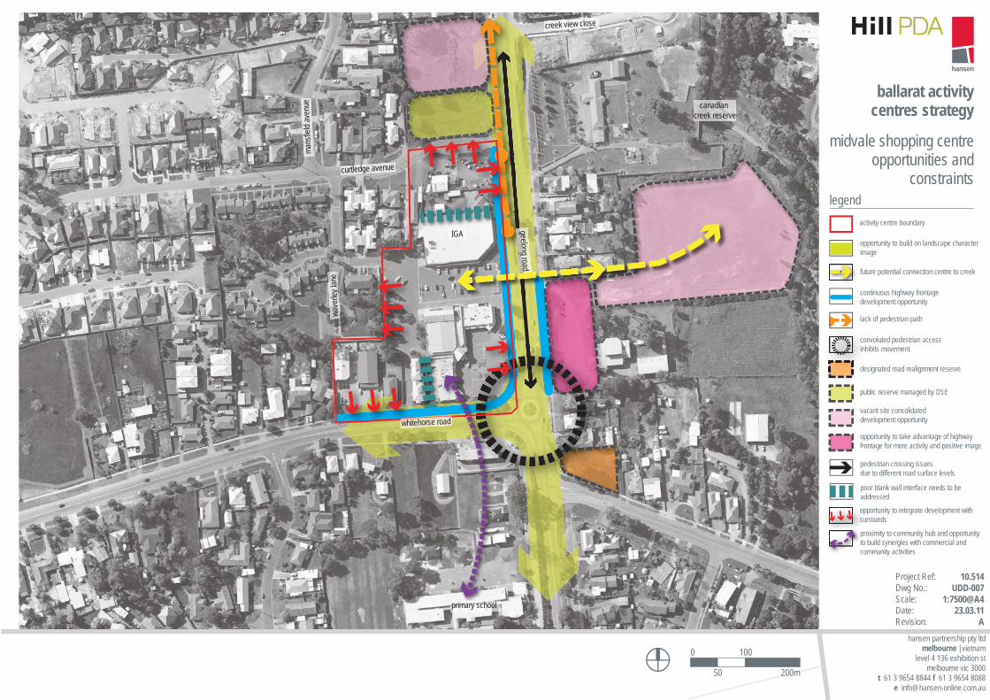
midvale shopping centreopportunities and
constraintslegend
activity centre boundary
opportunity to integrate development with surrounds
future potential connection centre to creek
continuous highway frontage development opportunity
lack of pedestrian path
convoluted pedestrian accessinhibits movement
designated road realignment reserve
pedestrian crossing issues due to different road surface levels
public reserve managed by DSE
vacant site consolidated development opportunity
poor blank wall interface needs to be addressed
opportunity to take advantage of highway frontage for more activity and positive image
proximity to community hub and opportunity to build synergies with commercial and community activities
opportunity to build on landscape character image
coninhi
des
opsus
proptc
p
Ballarat Activity Centres Strategy
M10005 Final P a g e | 86 Hill PDA
3.10 Northway – Neighbourhood Activity Centre
Location and Role
Located at the junction of Doveton Street and Norman Street, the Northway Neighbourhood Activity Centre is a
compact retail convenience centre. It is located approximately 2km to the north-west of Ballarat CBD and provides for
the needs of Ballarat North and to an extent, Invermay Park.
The centre is anchored by an IGA supermarket. Other occupants include a hairdresser, beauty salon, bakery, a
pharmacy and a number of take-away food stores.
Planning Designation
The centre is zoned Business 1 Zone (B1Z) by the Ballarat Planning Scheme. The centre is not affected by any
planning overlays.
Provision of Floorspace
Based on Hill PDA’s 2010 floorspace survey the centre provided around 1,700sqm of retail floorspace. The centre did
not provide any commercial uses nor did it have any vacancies at the time of survey.
Table 20 - Existing Floorspace in Northway Land Use Category Floorspace (sqm) Proportion of Total
Supermarket 1,071 62.7%
Specialty Food 289 16.9%
Cafes & Restaurants 74 4.3%
Personal Services 274 16.0%
Total Floorspace 1,708 100.0%
Source: Hill PDA (2010)
The largest proportion of floorspace (1,071sqm or 63%) related to the IGA supermarket followed by specialty food
stores (289sqm or 17%) and personal services (274sqm or 6%).
It is understood that Ryan’s Supa IGA has met with Council about a possible extension to their centre to include a
café and additional weather protection. They are in the process of preparing permit application reports for the
proposed additions.
Trade Area Identification
The trade area of Northway is fairly restricted by its limited offer and proximity and short drive times to Ballarat
Marketplace (ALDI), Ballarat CBD and Stockland Wendouree. However, to the east and north there are few other
food and grocery alternatives, with this Centre easily accessible via Doveton Street and Norman Street. As a result,
the centre meets the need of surrounding residential areas including Ballarat North and Invermay Park.
This modest trade area is likely to extend as far west as the railway line and Creswick Road, and to Howitt Street to
the south and the Western Freeway in the north and east, therefore comprising around 6,000 persons.
Ballarat Activity Centres Strategy
M10005 Final P a g e | 87 Hill PDA
Urban Design Issues
This is a small car based centre with the building forms set to the western and southern boundaries of the site and at-
grade car parking provided to the junction frontage. The centre is distinctly separate from the adjoining development,
turning its back on the Queen Elizabeth Midlands Centre to the west and the Midlands Terrace Retirement Village to
the south. The built form is single storey and has a low profile, notably when viewed from Norman Street. The centre
generally lacks the extent of landscaping encouraged in newer centres. Verges have been reduced in width along
Norman Street for angled kerbside parking which further serves to highlight the minimal landscape provision.
The loading areas to the west of the centre create a fairly visually unappealing streetscape from this approach along
Norman Street. Anecdotally, sightlines for vehicles exiting the car park onto Norman Street (at the western exit) are
difficult due to the positioning of parked cars and the configuration with footpaths for pedestrian movement.
Transport and Access
Doveton Street and Norman Street are single carriageways with a roundabout junction and provide connections to
local destinations. No turning lanes are provided into the centre from these roads. The centre is serviced by a bus
route (route 4 Invermay) which operates along Doveton Street, while both Norman and Doveton Street North have
formal on-road cycle tracks. Loading facilities for the centre are provided from Norman Street adjacent to the Queen
Elizabeth Midlands Centre.
The centre is focussed around a free at-grade car park which accommodates the majority of shoppers who arrive by
vehicle. An additional 16 angled car parks are provided along the Norman Street frontage. The compact nature of the
centre facilitates ease of access by pedestrians.
Existing Strengths and Weaknesses
The following section draws on some of the key findings from previous studies in addition to the comments raised
during focus group sessions and through observation during site visits.
Strengths
A compact pedestrian friendly centre.
Performs its role in the provision of basic goods and services to its catchment population.
An easily accessible centre by car, bus or cycle.
Strong growth is predicted for the local area due to future higher residential densities.
The centre performs better than other Ryan’s Supa IGA based centres with regards to access and traffic
movement.
Weaknesses
The centre is modest in size and constrained by surrounding land uses which restricts opportunities for
expansion.
The low availability of car parking reduces its attraction to shoppers, particularly during peak periods.
The most requested improvement to the centre according to Ryan’s Supa IGA is a coffee shop. However this will
be difficult to provide due to limited expansion opportunities.
Right turn out of driveway onto Doveton Street North during peak times is difficult and leads to traffic congestion.

ballarat activity centres strategy
northwayshopping centre
legendstudy area
hansen partnership pty ltdmelbourne | vietnam
level 4 136 exhibition stmelbourne vic 3000
t 61 3 9654 8844 f 61 3 9654 8088 e [email protected]
w hansen-online.com.au
Project Ref: Dwg No.:Scale:Date:Revision:
10.514 UDD-008
B0 25
50m10
norman street
dove
ton st
reet
north
IGA
brumby’s
cemetary
Ballarat Activity Centres Strategy
M10005 Final P a g e | 89 Hill PDA
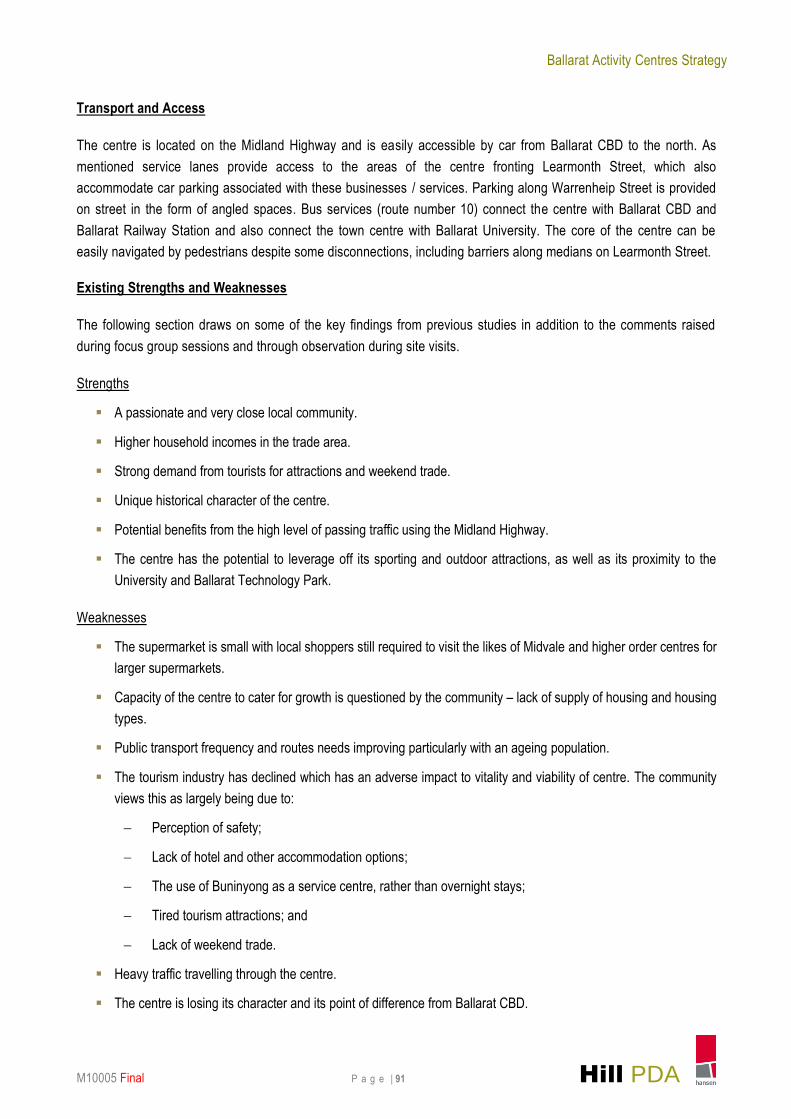
3.11 Buninyong – Neighbourhood Activity Centre
Location and Role
The Buninyong Neighbourhood Activity Centre is located at the southern end of the City along Learmonth Street and
Warrenheip Road. The centre provides for the everyday needs of the local community. It also has a strong attraction
to tourists and visitors owing to its heritage character, cafes and restaurants and location on the Midland Highway.
The key attractors to the centre are located in the defined core retail area and include a small Foodworks
supermarket, a pharmacy and a newsagent. Other services in the core retail area include a real estate agent, a bank,
a petrol station, physiotherapist, a Country Fire Authority Station, a community hall and several cafes, restaurants
and drinking establishments. The secondary retail core includes a branch of Australia Post, a hairdresser and a café.
Planning Designation
The core and secondary retail areas are designated as Business 1 Zone (B1Z) by the Ballarat Planning Scheme. An
additional area at the northern end of the centre on Warrenheip Road is designated Mixed Use Zone (MUZ). The
town centre is also affected by an Heritage Overlay Schedule 181 (Buninyong Heritage Precinct), as well as having
some individually listed buildings within the centre (Schedule 134 Buninyong Town Hall and Schedule 135 Former
Library, both of which are on the Victorian Heritage Register).
Buninyong is also subject to the Canadian Valley Outline Development Plan (ODP 2005). The Canadian Valley ODP
is based on limiting future residential development to land currently zoned for residential purposes (R1Z) , and
encourages infill development in suitable locations within existing developed residential areas.
Provision of Floorspace
Based on Hill PDA’s 2010 floorspace survey, the centre provided 6,459sqm of floorspace, of which 2,470sqm was
related to retail and a further 3,000sqm commercial floorspace.
Table 21 - Existing Floorspace in Buninyong Land Use Category Floorspace (sqm) Proportion of Total
Supermarket 300 4.6%
Specialty Food 443 6.9%
Specialty Non Food 294 4.6%
Convenience Store 95 1.5%
Cafes & Restaurants 538 8.3%
Take Away Food 151 2.3%
Personal Services 649 10.0%
Total Retail Floorspace 2,470 38.2%
Commercial - Finance 228 3.5%
Commercial - General 802 12.4%
Commercial - Government 1,027 15.9%
Commercial - Medical 866 13.4%
Commercial - Real Estate 137 2.1%
Total Commercial Floorspace 3,060 47.4%
Hotel / Pub / Club 327 5.1%
Other 228 3.5%
Vacant 374 5.8%
Total Floorspace 6,459 100.0%
Source: Hill PDA (2010)
Ballarat Activity Centres Strategy
M10005 Final P a g e | 90 Hill PDA
The largest single proportion of floorspace is related to government premises (1,027sqm or 16%) followed by medical
premises (866sqm or 13%) and general commercial floorspace (802sqm or 12%). At the time of survey, the centre
had a vacancy level of 6%.
Trade Area Identification
Buninyong provides for the local top-up shopping needs of its residents. However given the relatively limited range of
goods and services and the small sized supermarket, the trade area would not extend far to the north or west given
competing centres such as Midvale, Sebastopol and Ballarat CBD.
Notwithstanding this, owing to its location on the Midland Highway, the centre has the potential to be a successful
stop point for those travelling between Ballarat and Geelong. Focus group sessions revealed many tourists and
visitors to Ballarat often drive through Buninyong using it as a ‘service centre’, although it was recognised that
improvements were required to lengthen their stay and spend.
On this basis, the trade area for Buninyong incorporates the Buningyong settlement, extending north into Mount
Helen as far as the Geelong Road and Gear Avenue junction. The trade area also extends west to Magpie, and to the
boundary of the City of Ballarat to the south and east. The assumed primary trade area contains around 5,000
people.
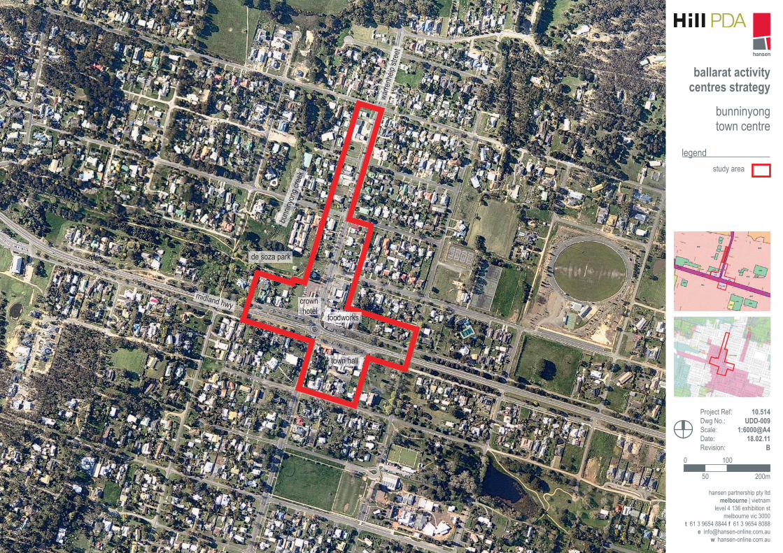
Urban Design Issues
The historic presentation of buildings in the centre, with particular reference to the grandeur of civic buildings, wide
boulevard style streets and the low scale built form with streetscape verandas, creates a distinctive traditio nal
character.
It is noted that much of the township is developed with residential dwellings which are primarily historic in character
and set back from the street frontage in contrast to the areas in closer proximity to the Learmonth/ Warrenheip Street
junction.
Established street tree planting and wide landscaped verges create a ‘green’ street presentation which is also a very
distinctive and valued feature. The presence of De Soza Park within the centre adds to this ‘green’ feel. The centre
overall, also retains a ‘rural’ character in keeping with the township as a whole.
There are large gaps in the street edge throughout the centre to the Crown Hotel with parts of the centre to the west
relatively isolated. A large at-grade car park which accommodates a drive through bottle shop dominates the western
side of Warrenheip Street north of the Crown Hotel. The wide streets also serve to separate the areas north and
south of Learmonth Street and there is also a sense of disconnection between the activity on Learmonth St reet and
those occurring on Warrenheip Street.
Service lanes which are associated with the centre are provided along Learmonth Street, but not Warrenheip Street.
The centre lacks connected pedestrian paths in parts of the centre which could be improved (i ncluding around bus
stops) to better facilitate walking.
Ballarat Activity Centres Strategy
M10005 Final P a g e | 91 Hill PDA
Transport and Access
The centre is located on the Midland Highway and is easily accessible by car from Ballarat CBD to the north. As
mentioned service lanes provide access to the areas of the centre fronting Learmonth Street, which also
accommodate car parking associated with these businesses / services. Parking along Warrenheip Street is provided
on street in the form of angled spaces. Bus services (route number 10) connect the centre with Ballarat CBD and
Ballarat Railway Station and also connect the town centre with Ballarat University. The core of the centre can be
easily navigated by pedestrians despite some disconnections, including barriers along medians on Learmonth Street.
Existing Strengths and Weaknesses
The following section draws on some of the key findings from previous studies in addition to the comments raised
during focus group sessions and through observation during site visits.
Strengths
A passionate and very close local community.
Higher household incomes in the trade area.
Strong demand from tourists for attractions and weekend trade.
Unique historical character of the centre.
Potential benefits from the high level of passing traffic using the Midland Highway.
The centre has the potential to leverage off its sporting and outdoor attractions, as well as its proximity to the
University and Ballarat Technology Park.
Weaknesses
The supermarket is small with local shoppers still required to visit the likes of Midvale and higher order centres for
larger supermarkets.
Capacity of the centre to cater for growth is questioned by the community – lack of supply of housing and housing
types.
Public transport frequency and routes needs improving particularly with an ageing population.
The tourism industry has declined which has an adverse impact to vitality and viability of centre. The community
views this as largely being due to:
Perception of safety;
Lack of hotel and other accommodation options;
The use of Buninyong as a service centre, rather than overnight stays;
Tired tourism attractions; and
Lack of weekend trade.
Heavy traffic travelling through the centre.
The centre is losing its character and its point of difference from Ballarat CBD.
ballarat activity centres strategy
bunninyong town centre
legendstudy area
hansen partnership pty ltdmelbourne | vietnam
level 4 136 exhibition stmelbourne vic 3000
t 61 3 9654 8844 f 61 3 9654 8088 e [email protected]
w hansen-online.com.au
Project Ref: Dwg No.:Scale:Date:Revision:
10.514 UDD-009
B0 100
200m50
125 250
midland hwy
warre
nheip
stre
et
foodworks
town hall
crown hotel
de soza park
bunn
inyon
g cree
k
ballarat activity centres strategy
hansen partnership pty ltdmelbourne | vietnam
level 4 136 exhibition stmelbourne vic 3000
t 61 3 9654 8844 f 61 3 9654 8088 e [email protected]
Project Ref: Dwg No.:Scale:Date:Revision:
10.514 UDD-009
A
0 100
200m50
opportunity to infill fragmented frontage
activity centre boundary
overcome road width and associated pedestrian crossing challenges
retain high quality boulevard treatment
opportunities for landscape street treatment
heritage area opportunity for tourism and identity improvements
opportunity to strengthen recreational linkages
mixed use area development opportunity to reflect traditional image and scaleopportunity to consolidate development along highway frontage
key opportunity to fill gaps in development along street
buninyong town centreopportunities and
constraintslegend
midland hwy
warre
nheip
stre
et
winte
r stre
et
winte
r stre
et
scott street
eyre st
eyre st
palmerston st
barkly st
barkly st
scott street
learmonth street
inglis
st
foodworks
town hall
crown hotel
de soza park
bunin
yong
cree
k
Ballarat Activity Centres Strategy
M10005 Final P a g e | 94 Hill PDA
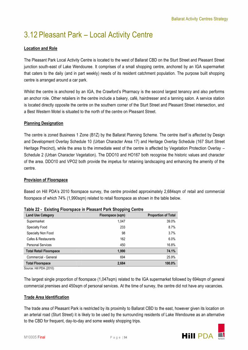
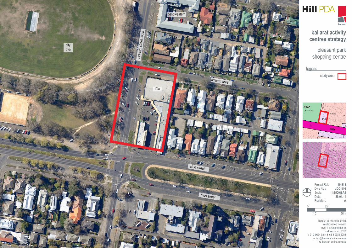
3.12 Pleasant Park – Local Activity Centre
Location and Role
The Pleasant Park Local Activity Centre is located to the west of Ballarat CBD on the Sturt Street and Pleasant Street
junction south-east of Lake Wendouree. It comprises of a small shopping centre, anchored by an IGA supermarket
that caters to the daily (and in part weekly) needs of its resident catchment population. The purpose built shopping
centre is arranged around a car park.
Whilst the centre is anchored by an IGA, the Crawford’s Pharmacy is the second largest tenancy and also performs
an anchor role. Other retailers in the centre include a bakery, café, hairdresser and a tanning salon. A service station
is located directly opposite the centre on the southern corner of the Sturt Street and Pleasant Street intersection, and
a Best Western Motel is situated to the north of the centre on Pleasant Street.
Planning Designation
The centre is zoned Business 1 Zone (B1Z) by the Ballarat Planning Scheme. The centre itself is affected by Design
and Development Overlay Schedule 10 (Urban Character Area 17) and Heritage Overlay Schedule (167 Sturt Street
Heritage Precinct), while the area to the immediate west of the centre is affected by Vegetation Protection Overlay –
Schedule 2 (Urban Character Vegetation). The DDO10 and HO167 both recognise the historic values and character
of the area. DDO10 and VPO2 both provide the impetus for retaining landscaping and enhancing the amenity of the
centre.
Provision of Floorspace
Based on Hill PDA’s 2010 floorspace survey, the centre provided approximately 2,684sqm of retail and commercial
floorspace of which 74% (1,990sqm) related to retail floorspace as shown in the table below.
Table 22 - Existing Floorspace in Pleasant Park Shopping Centre
Land Use Category Floorspace (sqm) Proportion of Total
Supermarket 1,047 39.0%
Specialty Food 233 8.7%
Specialty Non Food 98 3.7%
Cafes & Restaurants 162 6.0%
Personal Services 450 16.8%
Total Retail Floorspace 1,990 74.1%
Commercial - General 694 25.9%
Total Floorspace 2,684 100.0%
Source: Hill PDA (2010)
The largest single proportion of floorspace (1,047sqm) related to the IGA supermarket followed by 694sqm of general
commercial premises and 450sqm of personal services. At the time of survey, the centre did not have any vacancies.
Trade Area Identification
The trade area of Pleasant Park is restricted by its proximity to Ballarat CBD to the east, however given its location on
an arterial road (Sturt Street) it is likely to be used by the surrounding residents of Lake Wendouree as an alternative
to the CBD for frequent, day-to-day and some weekly shopping trips.
Ballarat Activity Centres Strategy
M10005 Final P a g e | 95 Hill PDA
Given the accessibility of the centre, passing trade will also significantly add to expenditure captured by this centre
(home from work shopping). The face-to-face surveys revealed that 60% of participants originated from Ballarat
Central, Ballarat West, Alfredton, Soldiers Hill and Mt Pleasant.
The trade area of Pleasant Park will be localised and is likely to extend to Eyre Street in the south, Drummond Street
North in the east, Morrison Street in the west and Mill Street in the north. Further north the trade area will be
restricted by the Howitt Street, Stockland Wendouree, and Alfredton centres in the west, and in the south by the Maxi
Food Activity Centre. This trade area contains around 5,000 people.
Urban Design Issues
Pleasant Park is a compact centre with a low building profile which is entirely single storey and part of a single
constructed centre. The centre is inward focussed towards the car park which results in blank side walls to Sussex
Street and Pleasant Street North. Wall detailing to Pleasant Street North has however sought to provide visual relief
to what could otherwise be perceived as an unattractive and inactive edge. This detailing also provides reference to
the area’s heritage characteristics. There is an additional freestanding form at the south west corner of the centre
which provides an active frontage to Pleasant Street North (accommodating additional retail outlets) but an inactive
frontage to the car parking area.
The centre is provided with a continuous covered pedestrian path albeit a relatively narrow space for pedestrians,
immediately abutting the car park. This cover is provided in the form of a bullnose veranda which is presumably
intended to reference the centre’s location within a key heritage precinct.
While the centre is located immediately opposite City Oval, and benefits from the mature plantings opposite the
centre, the centre itself suffers from a lack of landscaping. However, there is the opportunity to develop landscaping
in the centre to reflect the proximity to City Oval.
Transport and Access
The centre is easily accessible via Sturt Street and contains dedicated on and off -street car parking facilities for
shoppers. Users of the centre also have access to angled parking along both sides of Pleasant Street North and
along Sturt Street. It is noted however, that the provision of parking in this centre is restricted.
Three bus routes operate along Sturt Street (routes 15, 16 and 18) providing connections to the western and northern
suburbs of Ballarat. The centre is considered to be highly accessible by bus in comparison to other centres. The
centre is located within a reasonable walking distance from Ballarat CBD.
Loading facilities for the supermarket are provided off Sussex Street, with a secondary small loading area provided
towards the south west corner of the centre.
Existing Strengths and Weaknesses
The following section draws on some of the key findings from previous studies in addition to the comments raised
during focus group sessions and through observation during site visits.
Strengths
Adequately performs its role in the provision of goods and services to a localised catchment.
Is located in a highly accessible location with good access to Ballarat’s growth areas.
Ballarat Activity Centres Strategy
M10005 Final P a g e | 96 Hill PDA
High income households in the trade area.
Good retail mix on site.
There are no vacant units in the centre which suggests that it is performing well.
Weaknesses
The centre lacks landscaping amenity and provides some blank frontages to surrounding roads. Bringing such
frontages into more active use would create a better impression and would improve environmental quality.
The centre has no room to expand due to physical constraints of the site.
The car park is at capacity, although the car park at City Oval when not in use provides some parking relief.
Ballarat Activity Centres Strategy
M10005 Final P a g e | 98 Hill PDA
3.13 Maxi Food – Local Activity Centre
Location and Role
The Maxi Food Local Activity Centre is located at the junction of La Trobe and Pleasant Streets. It is situated to the
south-west of the Ballarat CBD and is anchored by the Maxi Food store. The centre performs a convenience retail
role supporting the needs of the local catchment.
Planning Designation
The Maxi Food shopping centre is zoned as a Mixed Use Zone (MUZ). The area is affected by a number of overlays
including an Environmental Audit Overlay, a Vegetation Protection Overlay – Schedule 2 (Urban Character
Vegetation) and a Design and Development Overlay – Schedule 4 (Urban Character Area 22). It is noted that the
latter two overlays affect only a small portion of the centre to the north east. VPO2 recognises the value of canopy
trees in the private realm whilst DDO4 seeks to retain the garden character and traditional form and scale of built
form in the area.
Provision of Floorspace
Based on Hill PDA’s 2010 floorspace survey, the centre provided approximately 3,300sqm of floorspace of which
80.3% related to retail uses as shown in the table below.
Table 23 - Existing Floorspace at Maxi Food Land Use Category Floorspace (sqm) Proportion of Total
Supermarket 2,449 74.0%
Specialty Food 209 6.3%
Total Retail Floorspace 2,658 80.3%
Commercial - Medical 542 16.4%
Total Commercial Floorspace 542 16.4%
Recreation and Fitness 111 3.4%
Total Floorspace 3,311 100.0%
Source: Hill PDA (2010)
The largest single portion of floorspace in the centre related to the supermarket (2,449sqm) followed by medical
premises (542sqm) and specialty food stores (209sqm). At the time of survey, the centre did not have any vacancies.
Trade Area Identification
Given the presence of competing shopping facilities at Sebastopol North and Stockland Wendouree, the trade area of
the centre is restricted to the local surrounding residential neighbourhood. On this basis, the trade area is likely to
include Redan and may include small parts of the adjoining suburbs of Lake Wendouree, Newington, Lake Gardens,
Ballarat Central, Golden Point, Mt Pleasant, Sebastopol and Delacombe. It is estimated that the trade area for this
centre includes around 6,000 people.
In addition, the centre is likely to capture expenditure from workers in the industrial precinct to the west.
Ballarat Activity Centres Strategy
M10005 Final P a g e | 99 Hill PDA
Urban Design Issues
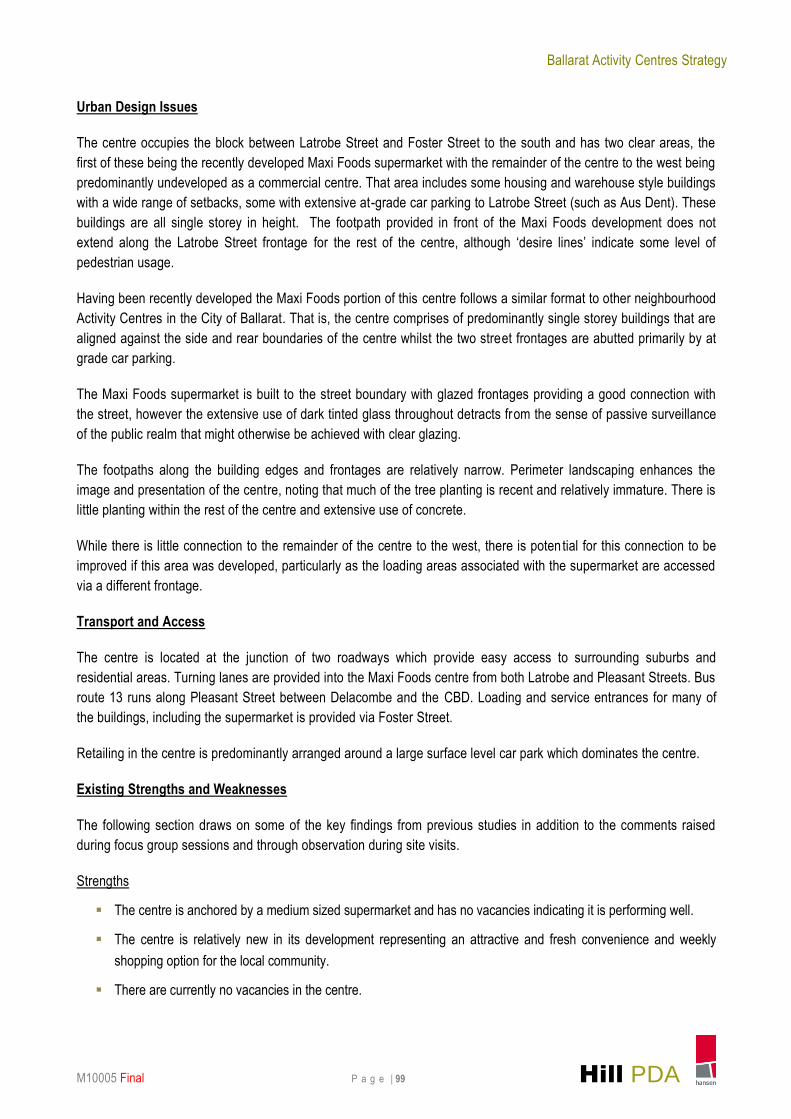
The centre occupies the block between Latrobe Street and Foster Street to the south and has two clear areas, the
first of these being the recently developed Maxi Foods supermarket with the remainder of the centre to the west being
predominantly undeveloped as a commercial centre. That area includes some housing and warehouse style buildings
with a wide range of setbacks, some with extensive at-grade car parking to Latrobe Street (such as Aus Dent). These
buildings are all single storey in height. The footpath provided in front of the Maxi Foods development does not
extend along the Latrobe Street frontage for the rest of the centre, although ‘desire lines’ indicate some level of
pedestrian usage.
Having been recently developed the Maxi Foods portion of this centre follows a similar format to other neighbourhood
Activity Centres in the City of Ballarat. That is, the centre comprises of predominantly single storey buildings that are
aligned against the side and rear boundaries of the centre whilst the two street frontages are abutted primarily by at
grade car parking.
The Maxi Foods supermarket is built to the street boundary with glazed frontages providing a good connection with
the street, however the extensive use of dark tinted glass throughout detracts from the sense of passive surveillance
of the public realm that might otherwise be achieved with clear glazing.
The footpaths along the building edges and frontages are relatively narrow. Perimeter landscaping enhances the
image and presentation of the centre, noting that much of the tree planting is recent and relatively immature. There is
little planting within the rest of the centre and extensive use of concrete.
While there is little connection to the remainder of the centre to the west, there is poten tial for this connection to be
improved if this area was developed, particularly as the loading areas associated with the supermarket are accessed
via a different frontage.
Transport and Access
The centre is located at the junction of two roadways which provide easy access to surrounding suburbs and
residential areas. Turning lanes are provided into the Maxi Foods centre from both Latrobe and Pleasant Streets. Bus
route 13 runs along Pleasant Street between Delacombe and the CBD. Loading and service entrances for many of
the buildings, including the supermarket is provided via Foster Street.
Retailing in the centre is predominantly arranged around a large surface level car park which dominates the centre.
Existing Strengths and Weaknesses
The following section draws on some of the key findings from previous studies in addition to the comments raised
during focus group sessions and through observation during site visits.
Strengths
The centre is anchored by a medium sized supermarket and has no vacancies indicating it is performing well.
The centre is relatively new in its development representing an attractive and fresh convenience and weekly
shopping option for the local community.
There are currently no vacancies in the centre.

ballarat activity centres strategy
maxi foodshopping centre
legendstudy area
hansen partnership pty ltdmelbourne | vietnam
level 4 136 exhibition stmelbourne vic 3000
t 61 3 9654 8844 f 61 3 9654 8088 e [email protected]
w hansen-online.com.au
Project Ref: Dwg No.:Scale:Date:Revision:
10.514 UDD-011
B0 25
50m10
pleas
ant s
treet
south
latrobe street
foster street
pleas
ant s
treet
maxi foods
anytime fitness blood donor
centre
pleasant street
reserve
Ballarat Activity Centres Strategy
M10005 Final P a g e | 101 Hill PDA
3.14 Alfredton ALDI – Local Activity Centre
Location and Role
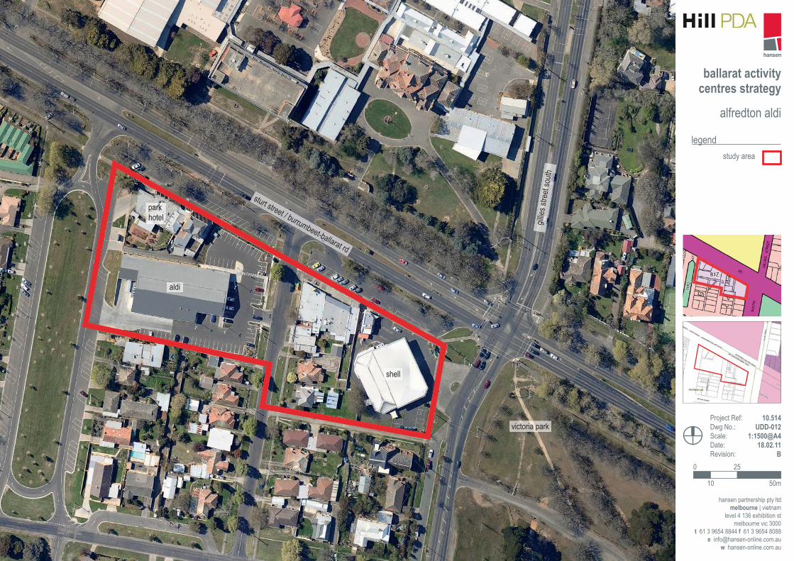
The Alfredton ALDI Local Activity Centre is situated on Sturt Street to the west of Ballarat CBD between the junction
of Gillies Street and Vale Street.
The centre functions as a retail convenience centre providing an ALDI store as a key anchor in addition to a discount
pharmacy, a post office, general store, liquor store, petrol station with convenience retail and a number of take away
food outlets.
Planning Designation
The centre is zoned Business 1 Zone (B1Z) by the Ballarat Planning Scheme. The centre is not affected by any
overlay controls.
Provision of Floorspace
Based on Hill PDA’s 2010 floorspace survey, the centre provided 3,852sqm of floorspace of which 96% related to
retail uses as shown in the table below.
Table 24 - Existing Floorspace at Alfredton ALDI
Land Use Category Floorspace (sqm) Proportion of Total
Supermarket 1,777 46.1%
Specialty Food 1,242 32.2%
Take Away Food 242 6.3%
Personal Services 437 11.3%
Total Retail Floorspace 3,698 96.0%
Commercial - Government 100 2.6%
Total Commercial Floorspace 100 2.6%
Vacant 54 1.4%
Total Floorspace 3,852 100.0%
Source: Hill PDA (2010). Note the bottle shop (832sqm) is noted within Specialty Food.
The largest proportion of floorspace (1,777sqm) related to the ALDI supermarket followed by the bottle shop
(832sqm) and personal services (437sqm) which includes a hairdresser and dry cleaning services.
Trade Area Identification
The Activity Centre’s trade area will be influenced by:
The proximity of competing centres with anchor supermarkets – particularly Stockland Wendouree, Howitt Street
and Sebastopol North; and
A lack of any ALDI supermarkets near Stockland Wendouree or Howitt Street.
The face-to-face surveys indicate that shoppers were attracted from Invermay and Miners Rest (20%), Delacombe
and Sebastopol (17%) and Ballarat Central, Ballarat West, Alfredton, Soldiers Hill, Mt Clear and Mt Pleasant (13%).
Ballarat Activity Centres Strategy
M10005 Final P a g e | 102 Hill PDA
As a result, the trade area for Alfredton ALDI includes much of the north and west of Ballarat, including the suburbs of
Alfredton, Lake Wendouree, Newington-Lake Gardens, and Wendouree. These suburbs contain some 25,000 people.
Urban Design Issues
The centre is relatively disjointed with a service station, strip shops, the ALDI Supermarket and hotel having little
relationship to each other. The building forms are similarly disparate, with varying alignments and setbacks. The
heights within the centre are generally single storey, with the exception of a portion of the hotel building which is two
storeys. The centre essentially functions as two portions with either side of Longley Street having a separate service
road and car parking area associated with it.
Pedestrian access is compromised within the centre with no clear, legible path, thus there is evidence of pedestrians
traversing garden beds and also having to navigate retaining walls, potentially causing damage to landscaping. In
addition, the centre is dominated by car orientated structures such as petrol stations, drive through bottle shops and
extensive at-grade car parking.
The ALDI car park is relatively barren with no shade structures or trees. The public realm does however incorporate
well with the established canopy of trees forming a boulevard planting treatment.
Transport and Access
Sturt Street forms the main east-west arterial route into Ballarat CBD and connects to the Western Highway. Gillies
Street is also a major local road. In light of the position of the centre at the junction of these two major roads it is we ll
connected to the road network and easily accessible by car and by public transport – both bus route 15 and 18 run
past this centre. No dedicated cycle paths run adjacent to the centre.
As mentioned, access to the centre are provided via dedicated service lanes, both of which provide on-street parking
with parallel spaces provided to the north and angled parking immediately adjacent to the shopfronts. Parking (two
hours) is free. The ALDI store has dedicated off street car parking and loading provided via Vale Street.
Existing Strengths and Weaknesses
The following section draws on some of the key findings from previous studies in addition to the comments raised
during focus group sessions and through observation during site visits.
Strengths
Situated at a key road junction and therefore benefits from good accessibility and passing trade.
Provides a range of retail goods and services which reflects its role in the local shopping hierarchy.
Weaknesses
Limited opportunities to expand the centre given that it is surrounded by residential uses and Sturt Street.
ballarat activity centres strategy
alfredton aldi
hansen partnership pty ltdmelbourne | vietnam
level 4 136 exhibition stmelbourne vic 3000
t 61 3 9654 8844 f 61 3 9654 8088 e [email protected]
w hansen-online.com.au
Project Ref: Dwg No.:Scale:Date:Revision:
10.514 UDD-012
B0 25
50m10
legendstudy area
sturt street / burrumbeet-ballarat rd
gillie
s stre
et so
uth
park hotel
aldi
shell
victoria park