BAdAKHSHAn - Amazon S3
20
BADAKHSHAN RELIGIOUS BUILDINGS Nasir Khusrau Shrine 312, Mullah Barat Mosque 320, Mir Yar Beg Shrine and Garden 322 OTHER BUILDINGS Hammam-e Kohna 326 NATURAL LANDSCAPES Wakhan Heritage Inventory 328 INTRODUCTION PHYSICAL CONSERVATION AND RESTORATION THE CHALLENGE OF PLANNING 304 312 326 328 336
Transcript of BAdAKHSHAn - Amazon S3
BAdAKHSHAn
RELIGIOUS BUILDINGSNasir Khusrau Shrine 312, Mullah Barat Mosque 320, Mir Yar Beg Shrine and Garden 322
OTHER BUILDINGSHammam-e Kohna 326
NATURAL LANDSCAPESWakhan Heritage Inventory 328
introduction
pHySicAL conSErvAtion And rEStorAtion
tHE cHALLEnGE of pLAnninG
304
312
326
328
336
introduction
BAdAKHSHAn

introductionThe mountainous north-eastern Afghan province of Badakshan shares its borders with Tajikistan, northern Pakistan and China. Originally part of the historic greater ‘Badakh-shan Region’, comprising areas of modern Tajikistan and northern Pakistan, the region was an important centre for trade in lapis lazuli as early as the fourth millennium BC and later during the active period of the Silk Road. Marco Polo wrote of its extraordin-ary rubies, part of the vast mineral wealth in the region, while travelling through the area towards the end of the thirteenth century. Ruled for centuries by kings (mirs) self-proclaimed to be descendants of Alexander of Macedonia (Alexander the Great), the last of whom was deposed during the Timurid dynasty in the fifteenth century, the region was fought over by the Mughal Empire and its rivals, the Uzbek khanates centred in Balkh. Although the region was gifted to Ahmad Shah Durrani (the founder of the modern state of Afghanistan) in 1750 by the amir of Bukhara, the province was officially conceded to the amir of Kabul and its boundaries established by a joint Anglo-Russian Boundary Commission only in 1888. Political motivations behind the demarcation of borders resulted in a thin strip of land, known as the Wakhan Corridor, being included in the Badakhshan province of Afghanistan in order to provide a buffer between Russian Central Asia and British India.
Badakhshan is the most seismically active region in Afghanistan, with frequent earthquakes measuring 6+ in magnitude on the Richter scale. The unavailability of traditional building materials, such as clay for making fired bricks, lime and wood, has meant that earthquakes have historically caused widespread damage to buildings constructed with stone. This may be one of the reasons why very few historic sites of significance remain in good condition in comparison with other regions with historic settlements. Building on AKTC’s broad conservation experience in Afghanistan, docu-mentation activities in Badakhshan commenced in 2007 with a series of field surveys in the Wakhan Corridor as part of the Wakhan Heritage Inventory, which comprises one hundred sites of historic or social significance in the area. In 2008, research was carried out on local folklore, which was subsequently presented in the Tales of the Wakhan, a booklet co-produced jointly with the Aga Khan Foundation that combines local legends passed on in oral history with material from the Wakhan Heritage Inven-tory and maps of the area.
Initial research and documentation efforts led to a 2010 agreement of cooperation with the Ministry of Information and Culture for the comprehensive restoration of the Nasir Khusrau Shrine in the Yamgan district of southern Badakhshan. Constructed
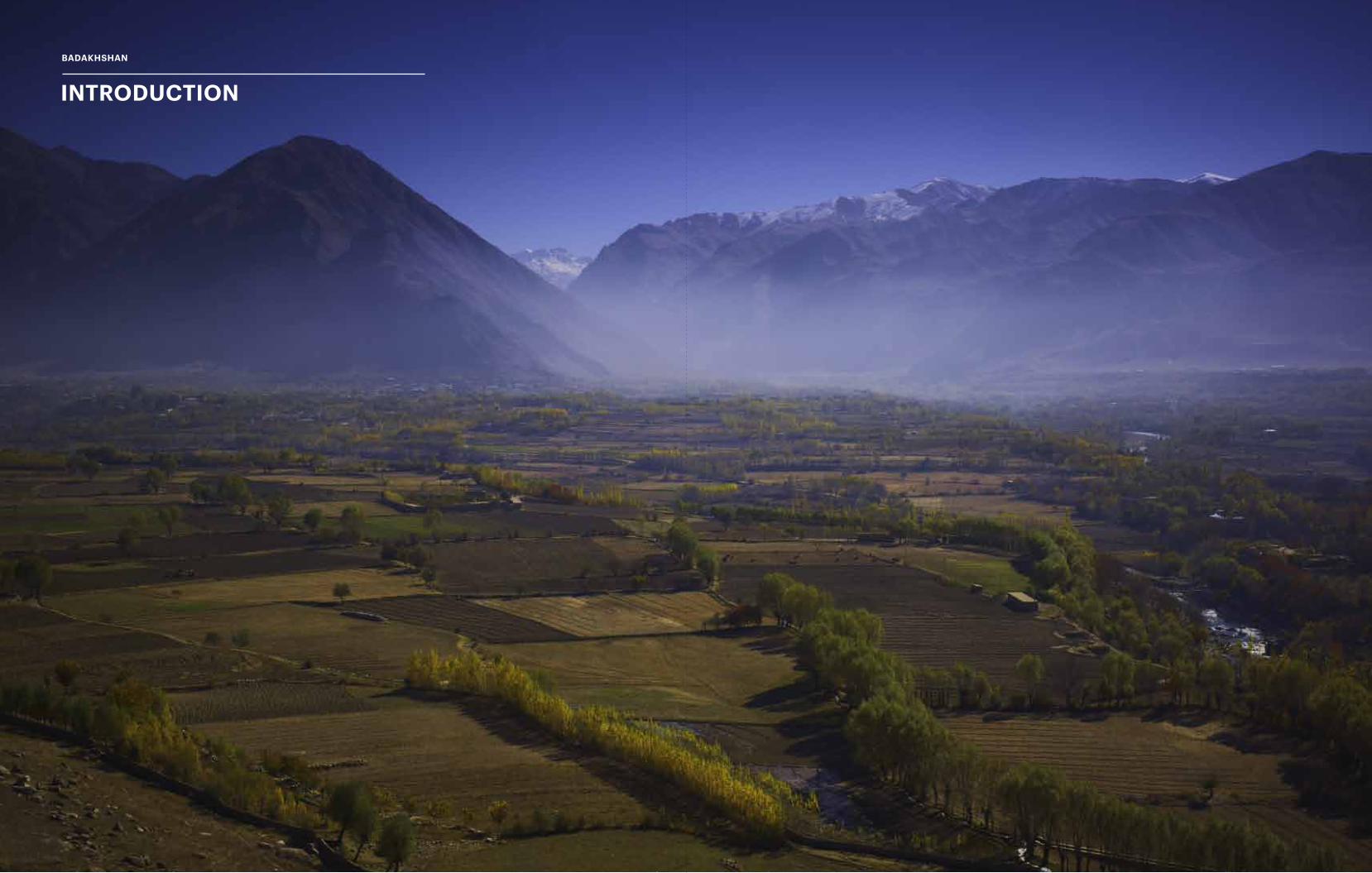
preceding pages, Badakhshan province in northern Afghanistan is located at the conver-gence of the Hindu Kush and pamir mountain ranges, with the previous district centre Baharak (seen here) placed at the crossroads of smaller valleys headed towards tajikistan, china and pakistan.
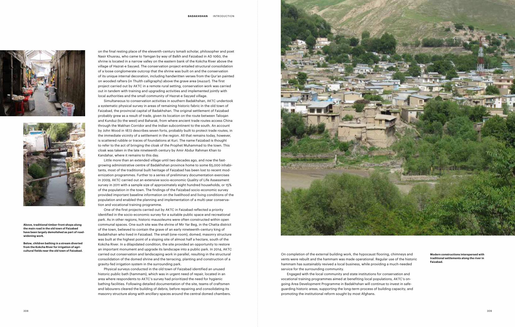
Above, informal hillside settlements con-structed above faizabad, the current district capital of Badakhshan.
right, the Kokcha river runs along a valley linking Baharak with districts in southern Badakshan, including jurm and yumgan.
the Wakhan corridor (seen here near Sahad-e Broghil) extends Afghanistan’s borders with tajikistan and pakistan, while providing a seventy-six-kilometre border with china to the east.
307306
On completion of the external building work, the hypocaust flooring, chimneys and vents were rebuilt and the hammam was made operational. Regular use of the historic hammam has sustainably revived a local business, while providing a much-needed service for the surrounding community.
Engaged with the local community and state institutions for conservation and vocational training programmes aimed at benefiting local populations, AKTC’s on- going Area Development Programme in Badakhshan will continue to invest in safe-guarding historic areas, supporting the long-term process of building capacity, and promoting the institutional reform sought by most Afghans.
on the final resting place of the eleventh-century Ismaili scholar, philosopher and poet Nasir Khusrau, who came to Yamgan by way of Balkh and Faizabad in AD 1060, the shrine is located in a narrow valley on the eastern bank of the Kokcha River above the village of Hazrat-e Sayyed. The conservation project entailed structural consolidation of a loose conglomerate outcrop that the shrine was built on and the conservation of its unique internal decoration, including handwritten verses from the Qur’an painted on wooded rafters (in Thulth calligraphy) above the grave area (mazar). The first project carried out by AKTC in a remote rural setting, conservation work was carried out in tandem with training and upgrading activities and implemented jointly with local authorities and the small community of Hazrat-e Sayyed village.
Simultaneous to conservation activities in southern Badakhshan, AKTC undertook a systematic physical survey in areas of remaining historic fabric in the old town of Faizabad, the provincial capital of Badakhshan. The original settlement of Faizabad probably grew as a result of trade, given its location on the route between Taloqan and Kunduz (to the west) and Baharak, from where ancient trade routes access China through the Wakhan Corridor and the Indian subcontinent to the south. An account by John Wood in 1872 describes seven forts, probably built to protect trade routes, in the immediate vicinity of a settlement in the region. All that remains today, however, is scattered rubble or traces of foundations at Kuri. The name Faizabad is thought to refer to the act of bringing the cloak of the Prophet Muhammad to the town. This cloak was taken in the late nineteenth century by Amir Abdur Rahman Khan to Kandahar, where it remains to this day.
Little more than an extended village until two decades ago, and now the fast-growing administrative centre of Badakhshan province home to some 65,000 inhabi-tants, most of the traditional built heritage of Faizabad has been lost to recent mod-ernization programmes. Further to a series of preliminary documentation exercises in 2009, AKTC carried out an extensive socio-economic Quality of Life Assessment survey in 2011 with a sample size of approximately eight hundred households, or 15% of the population in the town. The findings of the Faizabad socio-economic survey provided important baseline information on the livelihood and living conditions of the population and enabled the planning and implementation of a multi-year conserva-tion and vocational training programme.
One of the first projects carried out by AKTC in Faizabad reflected a priority identified in the socio-economic survey for a suitable public space and recreational park. As in other regions, historic mausoleums were often constructed within open communal spaces. One such site was the shrine of Mir Yar Beg, in the Chatta district of the town, believed to contain the grave of an early nineteenth-century king of Badakhshan who lived in Faizabad. The small (one-room), domed, masonry structure was built at the highest point of a sloping site of almost half a hectare, south of the Kokcha River. In a dilapidated condition, the site provided an opportunity to restore an important monument and upgrade its landscape into a public park. In 2014, AKTC carried out conservation and landscaping work in parallel, resulting in the structural consolidation of the domed shrine and the terracing, planting and construction of a gravity-fed irrigation system in the surrounding park.
Physical surveys conducted in the old town of Faizabad identified an unused historic public bath (hammam), which was in urgent need of repair, located in an area where respondents to AKTC’s survey had prioritized the need for hygienic bathing facilities. Following detailed documentation of the site, teams of craftsmen and labourers cleared the building of debris, before repairing and consolidating its masonry structure along with ancillary spaces around the central domed chambers.
Above, traditional timber-front shops along the main road in the old town of faizabad have been largely demolished as part of road-widening work.
Below, children bathing in a stream diverted from the Kokcha river for irrigation of agri-cultural fields near the old town of faizabad.
modern constructions interspersed with traditional settlements along the river in faizabad.
308 309
BAdAKHSHAn INTRODUCTION
pHySicAL conSErvAtion And rEStorAtion
BAdAKHSHAn
Nasir Khusrau Shrine
HiStory And cHArActEriSticSAs it stands today, the Nasir Khusrau Shrine, or ziyarat, is both a funerary structure, marking the grave of the great Persian writer and philosopher, and a place of prayer and pilgrimage. A fine example of vernacular construction, containing extraordinary decorative elements, the shrine is also a registered historic monument and protected under laws regarding the preservation and safeguarding of Afghanistan’s heritage.
The shrine was constructed on the final resting place of Nasir Khusrau, the eleventh-century Ismaili scholar, philosopher and poet, who came to Yamgan after his stay in Fatimid Cairo by way of Balkh and Faizabad in 1060. The village of Hazrat-e Sayyed is located in a narrow valley on the eastern bank of the Kokcha River in southern Badakhshan. Located in a remote area, the village is a seven-hour drive on unpaved roads from Faizabad, with major settlements at Baharak and Jurm along the route. The precarious route south from Jurm winds through precipitous valleys and the area is often inaccessible during the winter.
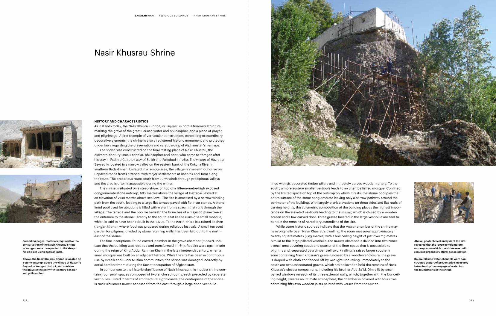
The shrine is situated on a steep slope, on top of a fifteen-metre-high exposed conglomerate stone outcrop, fifty metres above the village of Hazrat-e Sayyed at an elevation of 2100 metres above sea level. The site is accessed by a narrow winding path from the south, leading to a large flat terrace paved with flat river stones. A stone- lined pool used for ablutions is filled with water from a stream that runs through the village. The terrace and the pool lie beneath the branches of a majestic plane tree at the entrance to the shrine. Directly to the south-east lie the ruins of a small mosque, which is said to have been rebuilt in the 1920s. To the north, there is a ruined kitchen (langar khana), where food was prepared during religious festivals. A small terraced garden for pilgrims, divided by stone retaining walls, has been laid out to the north-east of the shrine.
The fine inscriptions, found carved in timber in the grave chamber (mazar), indi-cate that the building was repaired and transformed in 1697. Repairs were again made during the reign of King Abdur Rahman Khan in the late nineteenth century, when a small mosque was built on an adjacent terrace. While the site has been in continuous use by Ismaili and Sunni Muslim communities, the shrine was damaged indirectly by aerial bombardment during the Soviet occupation of Afghanistan.
In comparison to the historic significance of Nasir Khusrau, this modest shrine con- tains four small spaces composed of two enclosed rooms, each preceded by separate vestibules. Listed in terms of architectural significance, the centrepiece of the shrine is Nasir Khusrau’s mazar accessed from the east through a large open vestibule
lined with six decorated timber pillars and intricately carved wooden rafters. To the south, a more austere smaller vestibule leads to an unembellished mosque. Confined by the limited space on top of the outcrop on which it rests, the shrine occupies the entire surface of the stone conglomerate leaving only a narrow pathway around the perimeter of the building. With largely blank elevations on three sides and flat roofs of varying heights, the volumetric composition of the building places the highest impor-tance on the elevated vestibule leading to the mazar, which is closed by a wooden screen and a low carved door. Three graves located in the large vestibule are said to contain the remains of hereditary custodians of the site.
While some historic sources indicate that the mazar chamber of the shrine may have originally been Nasir Khusrau’s dwelling, the room measures approximately twenty square metres (4 × 5 metres) with a low ceiling height of just over 2.5 metres. Similar to the large pillared vestibule, the mazar chamber is divided into two zones: a small area covering about one quarter of the floor space that is accessible to pilgrims and, separated by a timber trelliswork railing, a raised larger southern zone containing Nasir Khusrau’s grave. Encased by a wooden enclosure, the grave is draped with cloth and fenced off by wrought-iron railing. Immediately to the south are two undecorated graves, which are believed to hold the remains of Nasir Khusrau’s closest companions, including his brother Abu Sa’id. Dimly lit by small barred windows on each of its three external walls, which, together with the low ceil-ing height, creates an intimate atmosphere, the chamber is covered with four rows containing fifty-two wooden joists painted with verses from the Qur’an.
preceding pages, materials required for the conservation of the nasir Khusrau Shrine in yumgan were transported to the steep hillside site using pack animals.
Above, the nasir Khusrau Shrine is located on a stone outcrop, above the village of Hazart-e Sayyed in yumgan district, and contains the grave of the early 11th-century scholar and philosopher.
Above, geotechnical analysis of the site revealed that the loose conglomerate outcrop, upon which the shrine was built, required urgent structural consolidation.
Below, hillside water channels were con-structed as part of preventative measures taken to stop the seepage of water into the foundations of the shrine.
312 313
BAdAKHSHAn RELIGIOUS BUILDINGS NASIR KHUSRAU SHRINE
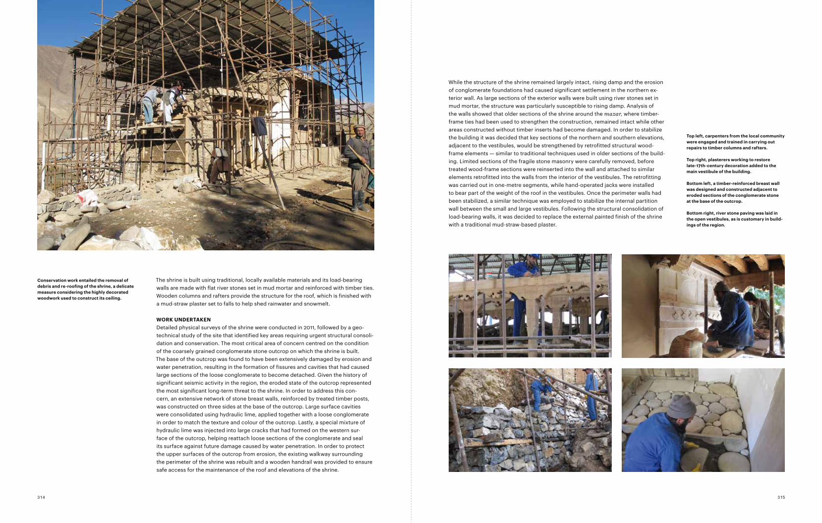
While the structure of the shrine remained largely intact, rising damp and the erosion of conglomerate foundations had caused significant settlement in the northern ex- terior wall. As large sections of the exterior walls were built using river stones set in mud mortar, the structure was particularly susceptible to rising damp. Analysis of the walls showed that older sections of the shrine around the mazar, where timber-frame ties had been used to strengthen the construction, remained intact while other areas constructed without timber inserts had become damaged. In order to stabilize the building it was decided that key sections of the northern and southern elevations, adjacent to the vestibules, would be strengthened by retrofitted structural wood-frame elements — similar to traditional techniques used in older sections of the build-ing. Limited sections of the fragile stone masonry were carefully removed, before treated wood-frame sections were reinserted into the wall and attached to similar elements retrofitted into the walls from the interior of the vestibules. The retrofitting was carried out in one-metre segments, while hand-operated jacks were installed to bear part of the weight of the roof in the vestibules. Once the perimeter walls had been stabilized, a similar technique was employed to stabilize the internal partition wall between the small and large vestibules. Following the structural consolidation of load-bearing walls, it was decided to replace the external painted finish of the shrine with a traditional mud-straw-based plaster.
The shrine is built using traditional, locally available materials and its load-bearing walls are made with flat river stones set in mud mortar and reinforced with timber ties. Wooden columns and rafters provide the structure for the roof, which is finished with a mud-straw plaster set to falls to help shed rainwater and snowmelt.
WorK undErtAKEnDetailed physical surveys of the shrine were conducted in 2011, followed by a geo-technical study of the site that identified key areas requiring urgent structural consoli-dation and conservation. The most critical area of concern centred on the condition of the coarsely grained conglomerate stone outcrop on which the shrine is built. The base of the outcrop was found to have been extensively damaged by erosion and water penetration, resulting in the formation of fissures and cavities that had caused large sections of the loose conglomerate to become detached. Given the history of significant seismic activity in the region, the eroded state of the outcrop represented the most significant long-term threat to the shrine. In order to address this con- cern, an extensive network of stone breast walls, reinforced by treated timber posts, was constructed on three sides at the base of the outcrop. Large surface cavities were consolidated using hydraulic lime, applied together with a loose conglomerate in order to match the texture and colour of the outcrop. Lastly, a special mixture of hydraulic lime was injected into large cracks that had formed on the western sur- face of the outcrop, helping reattach loose sections of the conglomerate and seal its surface against future damage caused by water penetration. In order to protect the upper surfaces of the outcrop from erosion, the existing walkway surrounding the perimeter of the shrine was rebuilt and a wooden handrail was provided to ensure safe access for the maintenance of the roof and elevations of the shrine.
conservation work entailed the removal of debris and re-roofing of the shrine, a delicate measure considering the highly decorated woodwork used to construct its ceiling.
top left, carpenters from the local community were engaged and trained in carrying out repairs to timber columns and rafters.
top right, plasterers working to restore late-17th-century decoration added to the main vestibule of the building.
Bottom left, a timber-reinforced breast wall was designed and constructed adjacent to eroded sections of the conglomerate stone at the base of the outcrop.
Bottom right, river stone paving was laid in the open vestibules, as is customary in build-ings of the region.
315314
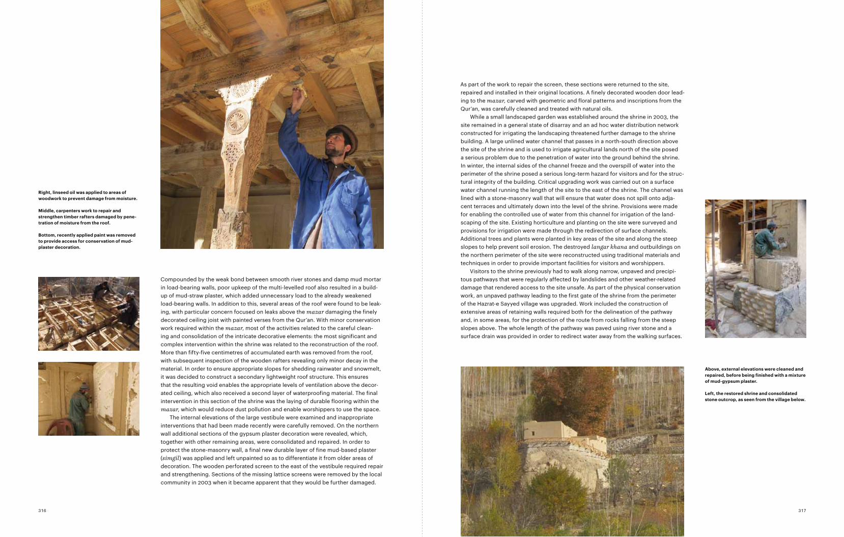
Compounded by the weak bond between smooth river stones and damp mud mortar in load-bearing walls, poor upkeep of the multi-levelled roof also resulted in a build-up of mud-straw plaster, which added unnecessary load to the already weakened load-bearing walls. In addition to this, several areas of the roof were found to be leak- ing, with particular concern focused on leaks above the mazar damaging the finely decorated ceiling joist with painted verses from the Qur’an. With minor conser vation work required within the mazar, most of the activities related to the careful clean-ing and consolidation of the intricate decorative elements: the most significant and complex intervention within the shrine was related to the reconstruction of the roof. More than fifty-five centimetres of accumulated earth was removed from the roof, with subsequent inspection of the wooden rafters revealing only minor decay in the material. In order to ensure appropriate slopes for shedding rainwater and snowmelt, it was decided to construct a secondary lightweight roof structure. This ensures that the resulting void enables the appropriate levels of ventilation above the decor-ated ceiling, which also received a second layer of waterproofing material. The final intervention in this section of the shrine was the laying of durable flooring within the mazar, which would reduce dust pollution and enable worshippers to use the space.
The internal elevations of the large vestibule were examined and inappropriate interventions that had been made recently were carefully removed. On the northern wall additional sections of the gypsum plaster decoration were revealed, which, together with other remaining areas, were consolidated and repaired. In order to protect the stone-masonry wall, a final new durable layer of fine mud-based plaster (simgil) was applied and left unpainted so as to differentiate it from older areas of decoration. The wooden perforated screen to the east of the vestibule required repair and strengthening. Sections of the missing lattice screens were removed by the local community in 2003 when it became apparent that they would be further damaged.
As part of the work to repair the screen, these sections were returned to the site, repaired and installed in their original locations. A finely decorated wooden door lead- ing to the mazar, carved with geometric and floral patterns and inscriptions from the Qur’an, was carefully cleaned and treated with natural oils.
While a small landscaped garden was established around the shrine in 2003, the site remained in a general state of disarray and an ad hoc water distribution network constructed for irrigating the landscaping threatened further damage to the shrine building. A large unlined water channel that passes in a north-south direction above the site of the shrine and is used to irrigate agricultural lands north of the site posed a serious problem due to the penetration of water into the ground behind the shrine. In winter, the internal sides of the channel freeze and the overspill of water into the perimeter of the shrine posed a serious long-term hazard for visitors and for the struc-tural integrity of the building. Critical upgrading work was carried out on a surface water channel running the length of the site to the east of the shrine. The channel was lined with a stone-masonry wall that will ensure that water does not spill onto adja-cent terraces and ultimately down into the level of the shrine. Provisions were made for enabling the controlled use of water from this channel for irrigation of the land-scaping of the site. Existing horticulture and planting on the site were surveyed and provisions for irrigation were made through the redirection of surface channels. Additional trees and plants were planted in key areas of the site and along the steep slopes to help prevent soil erosion. The destroyed langar khana and outbuildings on the northern perimeter of the site were reconstructed using traditional materials and techniques in order to provide important facilities for visitors and worshippers.
Visitors to the shrine previously had to walk along narrow, unpaved and precipi-tous pathways that were regularly affected by landslides and other weather-related damage that rendered access to the site unsafe. As part of the physical conservation work, an unpaved pathway leading to the first gate of the shrine from the perimeter of the Hazrat-e Sayyed village was upgraded. Work included the construction of extensive areas of retaining walls required both for the delineation of the pathway and, in some areas, for the protection of the route from rocks falling from the steep slopes above. The whole length of the pathway was paved using river stone and a surface drain was provided in order to redirect water away from the walking surfaces.
Above, external elevations were cleaned and repaired, before being finished with a mixture of mud-gypsum plaster.
Left, the restored shrine and consolidated stone outcrop, as seen from the village below.
right, linseed oil was applied to areas of woodwork to prevent damage from moisture.
middle, carpenters work to repair and strengthen timber rafters damaged by pene-tration of moisture from the roof.
Bottom, recently applied paint was removed to provide access for conservation of mud-plaster decoration.
317316
5m0GF RCP Plan
Section A-A5m0
25m0
Site PlanNasir Khusraw Shrine
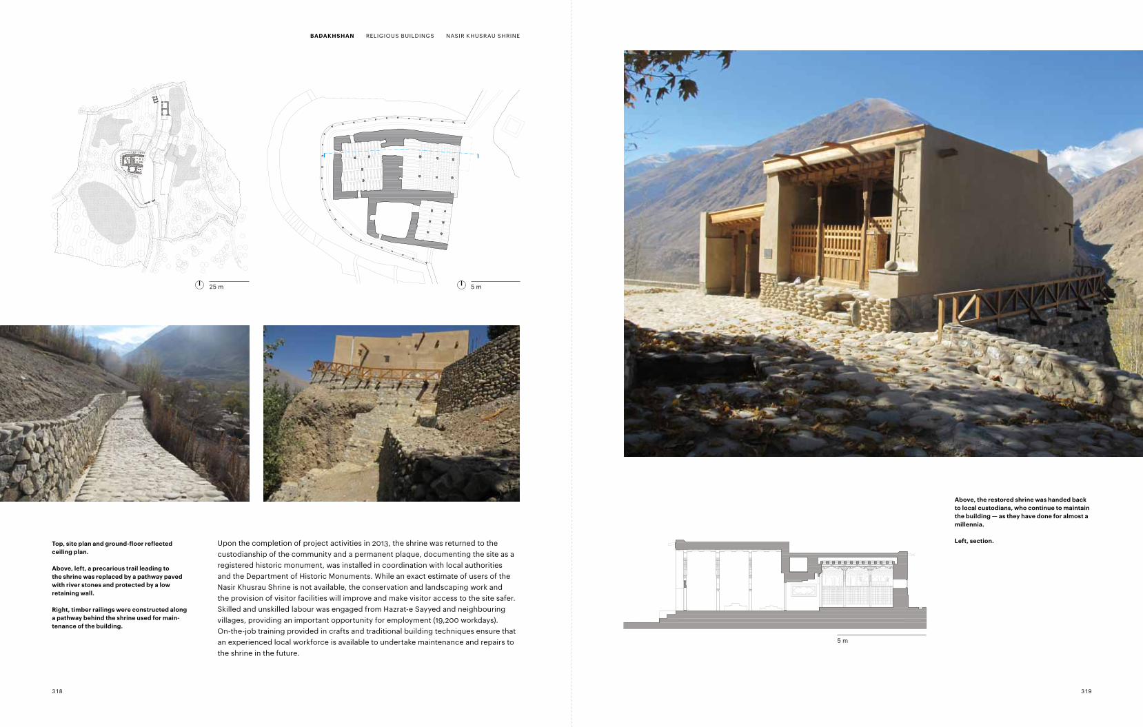
Upon the completion of project activities in 2013, the shrine was returned to the custodianship of the community and a permanent plaque, documenting the site as a registered historic monument, was installed in coordination with local authorities and the Department of Historic Monuments. While an exact estimate of users of the Nasir Khusrau Shrine is not available, the conservation and landscaping work and the provision of visitor facilities will improve and make visitor access to the site safer. Skilled and unskilled labour was engaged from Hazrat-e Sayyed and neighbouring villages, providing an important opportunity for employment (19,200 workdays). On-the-job training provided in crafts and traditional building techniques ensure that an experienced local workforce is available to undertake maintenance and repairs to the shrine in the future.
top, site plan and ground-floor reflected ceiling plan.
Above, left, a precarious trail leading to the shrine was replaced by a pathway paved with river stones and protected by a low retaining wall.
right, timber railings were constructed along a pathway behind the shrine used for main-tenance of the building.
Above, the restored shrine was handed back to local custodians, who continue to maintain the building — as they have done for almost a millennia.
Left, section.
5 m
25 m 5 m
318 319
BAdAKHSHAn RELIGIOUS BUILDINGS NASIR KHUSRAU SHRINE
Mullah Barat Mosque
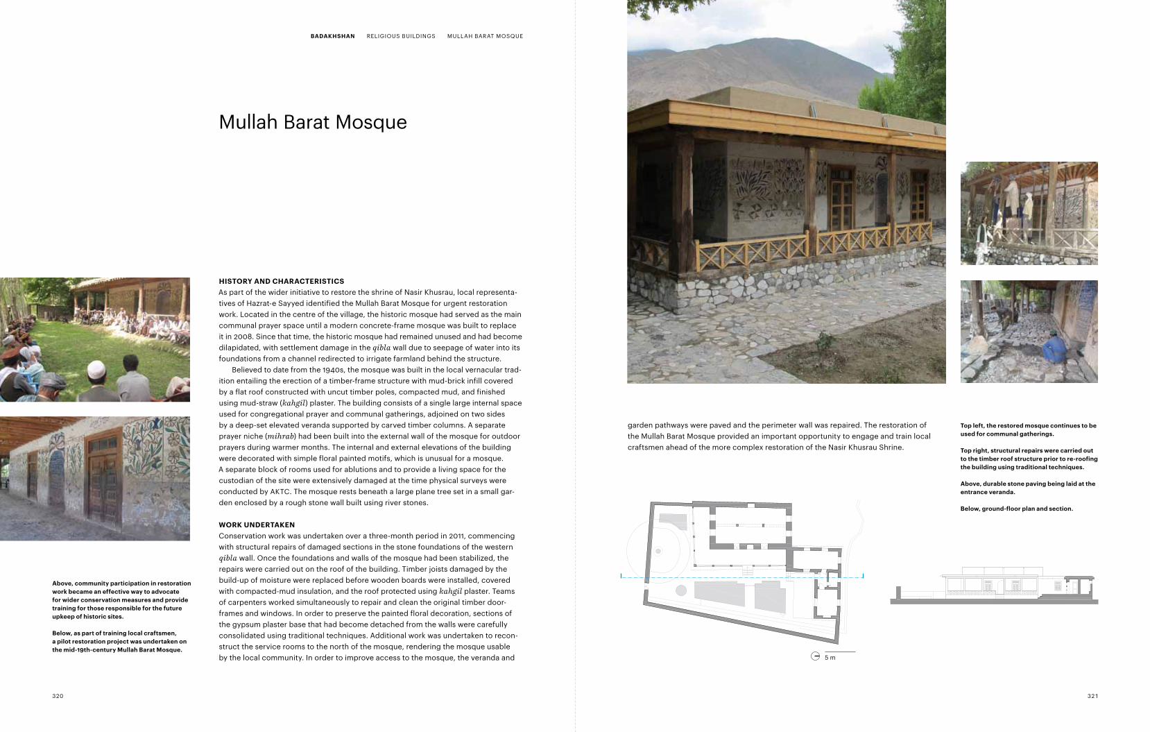
HiStory And cHArActEriSticSAs part of the wider initiative to restore the shrine of Nasir Khusrau, local representa-tives of Hazrat-e Sayyed identified the Mullah Barat Mosque for urgent restoration work. Located in the centre of the village, the historic mosque had served as the main communal prayer space until a modern concrete-frame mosque was built to replace it in 2008. Since that time, the historic mosque had remained unused and had become dilapidated, with settlement damage in the qibla wall due to seepage of water into its foundations from a channel redirected to irrigate farmland behind the structure.
Believed to date from the 1940s, the mosque was built in the local vernacular trad-ition entailing the erection of a timber-frame structure with mud-brick infill covered by a flat roof constructed with uncut timber poles, compacted mud, and finished using mud-straw (kahgil) plaster. The building consists of a single large internal space used for congregational prayer and communal gatherings, adjoined on two sides by a deep-set elevated veranda supported by carved timber columns. A separ ate prayer niche (mihrab) had been built into the external wall of the mosque for outdoor prayers during warmer months. The internal and external elevations of the building were decorated with simple floral painted motifs, which is unusual for a mosque. A separate block of rooms used for ablutions and to provide a living space for the custodian of the site were extensively damaged at the time physical surveys were conducted by AKTC. The mosque rests beneath a large plane tree set in a small gar-den enclosed by a rough stone wall built using river stones.
WorK undErtAKEnConservation work was undertaken over a three-month period in 2011, commencing with structural repairs of damaged sections in the stone foundations of the western qibla wall. Once the foundations and walls of the mosque had been stabilized, the repairs were carried out on the roof of the building. Timber joists damaged by the build-up of moisture were replaced before wooden boards were installed, covered with compacted-mud insulation, and the roof protected using kahgil plaster. Teams of carpenters worked simultaneously to repair and clean the original timber door-frames and windows. In order to preserve the painted floral decoration, sections of the gypsum plaster base that had become detached from the walls were carefully consolidated using traditional techniques. Additional work was undertaken to recon-struct the service rooms to the north of the mosque, rendering the mosque usable by the local community. In order to improve access to the mosque, the veranda and
garden pathways were paved and the perimeter wall was repaired. The restoration of the Mullah Barat Mosque provided an important opportunity to engage and train local craftsmen ahead of the more complex restoration of the Nasir Khusrau Shrine.
5m0
Ground Floor Plan
Mullah Barat Mosque
5m0Section A-AMullah Barat Mosque
Above, community participation in restoration work became an effective way to advocate for wider conservation measures and provide training for those responsible for the future upkeep of historic sites.
Below, as part of training local craftsmen, a pilot restoration project was undertaken on the mid-19th-century mullah Barat mosque.
top left, the restored mosque continues to be used for communal gatherings.
top right, structural repairs were carried out to the timber roof structure prior to re-roofing the building using traditional techniques.
Above, durable stone paving being laid at the entrance veranda.
Below, ground-floor plan and section.
5 m
320 321
BAdAKHSHAn RELIGIOUS BUILDINGS MULLAH BARAT MOSQUE
Mir Yar Beg Shrine and Garden
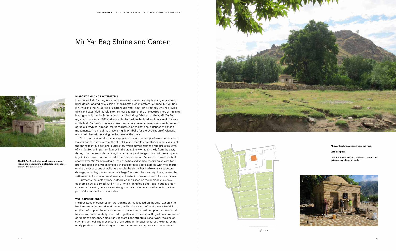
HiStory And cHArActEriSticSThe shrine of Mir Yar Beg is a small (one-room) stone-masonry building with a fired-brick dome, located on a hillside in the Chatta area of eastern Faizabad. Mir Yar Beg inherited the throne as mir of Badakhshan (1815–44) from his father, who had levied taxes and expanded his rule into Kashgar and part of the Chinese province of xinjiang. Having initially lost his father’s territories, including Faizabad to rivals, Mir Yar Beg regained the town in 1822 and rebuilt his fort, where he lived until poisoned by a rival in 1844. Mir Yar Beg’s Shrine is one of few remaining monuments, outside the vicinity of the old town of Faizabad, that is registered on the national database of historic monuments. The site of his grave is highly symbolic for the population of Faizabad, who credit him with reviving the fortunes of the town.
The shrine is located under a large plane tree on a raised platform area, accessed via an informal pathway from the street. Carved marble gravestones in the vicinity of the shrine identify additional burial sites, which may contain the remains of relatives of Mir Yar Beg or important figures in the area. Entry to the shrine is from the east, through narrow steps descending into a partially submerged room with small open-ings in its walls covered with traditional timber screens. Believed to have been built shortly after Mir Yar Beg’s death, the shrine has had ad hoc repairs on at least two previous occasions, which entailed the use of loose debris applied with mud mortar on the upper sections of walls. As a result, the shrine has had extensive structural damage, including the formation of a large fracture in its masonry dome, caused by settlement in foundations and seepage of water into areas of backfill above the wall.
Further to requests by local authorities and based on the findings of a socio- economic survey carried out by AKTC, which identified a shortage in public green spaces in the town, conservation designs entailed the creation of a public park as part of the restoration of the shrine.
WorK undErtAKEnThe first stage of conservation work on the shrine focused on the stabilization of its brick-masonry dome and load-bearing walls. Thick layers of mud-plaster backfill on the roof, applied by locals in order to prevent leaks, had compounded structural failures and were carefully removed. Together with the dismantling of previous areas of repair, the masonry dome was uncovered and structural repair work focused on stitching vertical fractures that had formed near the ‘squinches’ of the dome, using newly produced traditional square bricks. Temporary supports were constructed
the mir yar Beg Shrine was in a poor state of repair and its surrounding landscape inacces-sible to the community.
0Mir Yar Beg Site Plan
10m
Above, the shrine as seen from the road.
Left, site plan.
Below, masons work to repair and repoint the external load-bearing walls.
10 m
322 323
BAdAKHSHAn RELIGIOUS BUILDINGS MIR YAR BEG SHRINE AND GARDEN
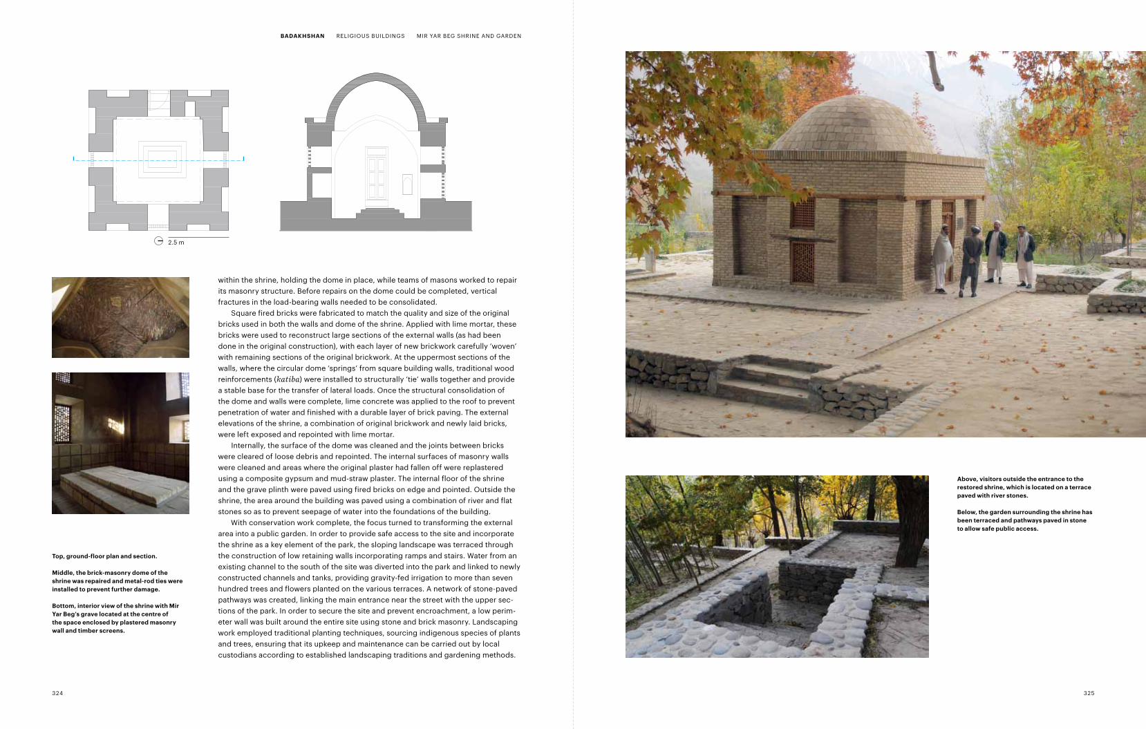
within the shrine, holding the dome in place, while teams of masons worked to repair its masonry structure. Before repairs on the dome could be completed, vertical fractures in the load-bearing walls needed to be consolidated.
Square fired bricks were fabricated to match the quality and size of the original bricks used in both the walls and dome of the shrine. Applied with lime mortar, these bricks were used to reconstruct large sections of the external walls (as had been done in the original construction), with each layer of new brickwork carefully ‘woven’ with remaining sections of the original brickwork. At the uppermost sections of the walls, where the circular dome ‘springs’ from square building walls, traditional wood reinforcements (katiba) were installed to structurally ‘tie’ walls together and provide a stable base for the transfer of lateral loads. Once the structural consolidation of the dome and walls were complete, lime concrete was applied to the roof to prevent penetration of water and finished with a durable layer of brick paving. The external elevations of the shrine, a combination of original brickwork and newly laid bricks, were left exposed and repointed with lime mortar.
Internally, the surface of the dome was cleaned and the joints between bricks were cleared of loose debris and repointed. The internal surfaces of masonry walls were cleaned and areas where the original plaster had fallen off were replastered using a composite gypsum and mud-straw plaster. The internal floor of the shrine and the grave plinth were paved using fired bricks on edge and pointed. Outside the shrine, the area around the building was paved using a combination of river and flat stones so as to prevent seepage of water into the foundations of the building.
With conservation work complete, the focus turned to transforming the external area into a public garden. In order to provide safe access to the site and incorporate the shrine as a key element of the park, the sloping landscape was terraced through the construction of low retaining walls incorporating ramps and stairs. Water from an existing channel to the south of the site was diverted into the park and linked to newly constructed channels and tanks, providing gravity-fed irrigation to more than seven hundred trees and flowers planted on the various terraces. A network of stone-paved pathways was created, linking the main entrance near the street with the upper sec-tions of the park. In order to secure the site and prevent encroachment, a low perim-e ter wall was built around the entire site using stone and brick masonry. Landscaping work employed traditional planting techniques, sourcing indigenous species of plants and trees, ensuring that its upkeep and maintenance can be carried out by local custodians according to established landscaping traditions and gardening methods.
2.5m0Ground Floor Plan
Mir Yar Beg
2.5m0Section A-AMir Yar Beg
Above, visitors outside the entrance to the restored shrine, which is located on a terrace paved with river stones.
Below, the garden surrounding the shrine has been terraced and pathways paved in stone to allow safe public access.
top, ground-floor plan and section.
middle, the brick-masonry dome of the shrine was repaired and metal-rod ties were installed to prevent further damage.
Bottom, interior view of the shrine with mir yar Beg’s grave located at the centre of the space enclosed by plastered masonry wall and timber screens.
2.5 m
324 325
BAdAKHSHAn RELIGIOUS BUILDINGS MIR YAR BEG SHRINE AND GARDEN
Hammam-e Kohna
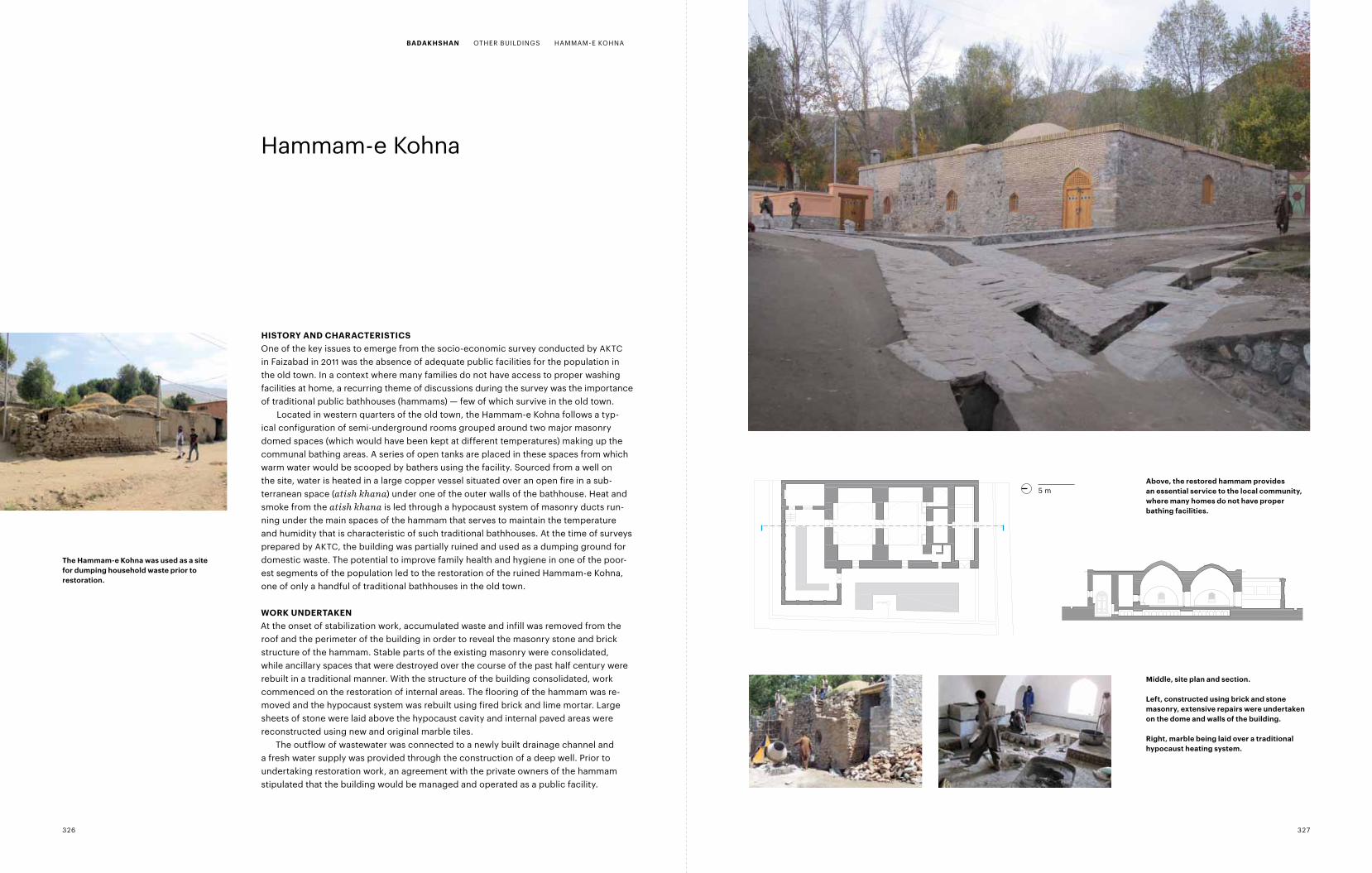
HiStory And cHArActEriSticSOne of the key issues to emerge from the socio-economic survey conducted by AKTC in Faizabad in 2011 was the absence of adequate public facilities for the population in the old town. In a context where many families do not have access to proper washing facilities at home, a recurring theme of discussions during the survey was the importance of traditional public bathhouses (hammams) — few of which survive in the old town.
Located in western quarters of the old town, the Hammam-e Kohna follows a typ - ical configuration of semi-underground rooms grouped around two major masonry domed spaces (which would have been kept at different temperatures) making up the communal bathing areas. A series of open tanks are placed in these spaces from which warm water would be scooped by bathers using the facility. Sourced from a well on the site, water is heated in a large copper vessel situated over an open fire in a sub-terranean space (atish khana) under one of the outer walls of the bathhouse. Heat and smoke from the atish khana is led through a hypocaust system of masonry ducts run-ning under the main spaces of the hammam that serves to maintain the temperature and humidity that is characteristic of such traditional bathhouses. At the time of surveys prepared by AKTC, the building was partially ruined and used as a dumping ground for domestic waste. The potential to improve family health and hygiene in one of the poor-est segments of the population led to the restoration of the ruined Hammam-e Kohna, one of only a handful of traditional bathhouses in the old town.
WorK undErtAKEnAt the onset of stabilization work, accumulated waste and infill was removed from the roof and the perimeter of the building in order to reveal the masonry stone and brick structure of the hammam. Stable parts of the existing masonry were consolidated, while ancillary spaces that were destroyed over the course of the past half century were rebuilt in a traditional manner. With the structure of the building consolidated, work commenced on the restoration of internal areas. The flooring of the hammam was re- moved and the hypocaust system was rebuilt using fired brick and lime mortar. Large sheets of stone were laid above the hypocaust cavity and internal paved areas were reconstructed using new and original marble tiles.
The outflow of wastewater was connected to a newly built drainage channel and a fresh water supply was provided through the construction of a deep well. Prior to undertaking restoration work, an agreement with the private owners of the hammam stipulated that the building would be managed and operated as a public facility.
5m0
Site PlanHammam-e Kohna
5m0Section A-AHammam-e Kohna
the Hammam-e Kohna was used as a site for dumping household waste prior to restor ation.
middle, site plan and section.
Left, constructed using brick and stone masonry, extensive repairs were undertaken on the dome and walls of the building.
right, marble being laid over a traditional hypocaust heating system.
Above, the restored hammam provides an essential service to the local community, where many homes do not have proper bathing facilities.
5 m
326 327
BAdAKHSHAn OTHER BUILDINGS HAMMAM-E KOHNA
Wakhan Heritage Inventory
introductionBased on stylistic evidence from the many petroglyphs in the area, the Wakhan Corridor and the Pamirs have been settled or crossed by humans since the Lower Palaeolithic era, around 100,000 years ago. Research in the Upper Amu Darya region confirms some form of habitation from this era, and there is evidence that the Silk Road, which linked the trading centres of western China with the Mediterranean and Europe, existed for some 1700 years between 329 BC and 1400 AD. Chinese accounts mention the Wakhan region as early as the seventh century, when both Tang and Tibetan rulers tried to benefit from this 8000-kilometre trade route that linked Yarkand and Merv via Bactria, passing through the Little Pamir and the Wakhan Corridor.
One of the earliest known accounts of the Pamirs is by a Chinese pilgrim Hsuan Tsang (or xuanzang), who travelled for seventeen years to India via Afghanistan, re- turning to China in AD 644. Passing through Badakhshan and the Pamirs (the Po-mi-lo), he describes the Pamirs as: “Six thousand li from east to west, and a hundred li from south to north. It is situated between two snowy mountains. The cold is glacial, and the wind furious. Snow falls even in spring and summer, day and night the wind rages. Grain and fruit cannot grow there, and trees are few and far between. In the middle of the valley is a large lake, situated in the centre of the world on a plateau of prodigious height (from The Great Tang Dynasty Record of the Western Regions, AD 646).”
The province of Badakhshan lies in the north-east of the country and is bordered to the north by the Pamir range of Tajikistan and to the south by the Hindu Kush in Pakistan. Wakhan district occupies a narrow finger of land running 360 kilometres east from Ishkashim, towards the Chinese frontier. Although administratively defined as a single district of Wakhan, the Afghan Pamirs are usually referred to as a separate geographic entity. The Wakhan Corridor, which is deeply incised as a result of the action of the Panj River, is in parts divided into upper and lower sections along the south side of the Panj and the Wakhan Rivers. The Lower Wakhan comprises an area along the course of the Panj between Ishkashim and Qala-e Panja. The Upper Wakhan, on the other hand, comprises the area beyond Goz Khon (where the Panj turns north-east into the Great Pamir) along the Wakhan River to Sarhad-e Broghil, which is the most easterly village before the Little Pamir range. Both the upper and lower parts are between two and three kilometres wide (although much narrower in parts of the Upper Wakhan), and are primarily settled by Wakhi communities, which are believed to comprise sixty-seven settlements ranging in size from three to 138 households.
A Kyrgyz shrine near the village of ishkashim at the entrance to the Wakhan corridor.
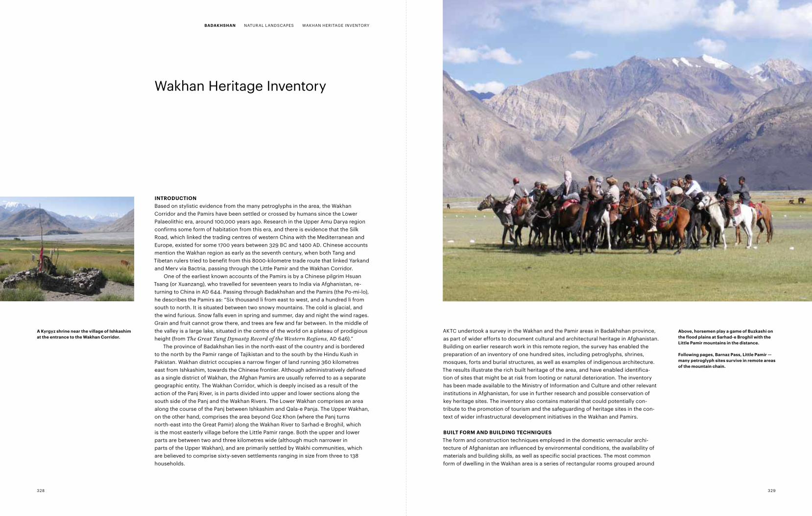
Above, horsemen play a game of Buzkashi on the flood plains at Sarhad-e Broghil with the Little pamir mountains in the distance.
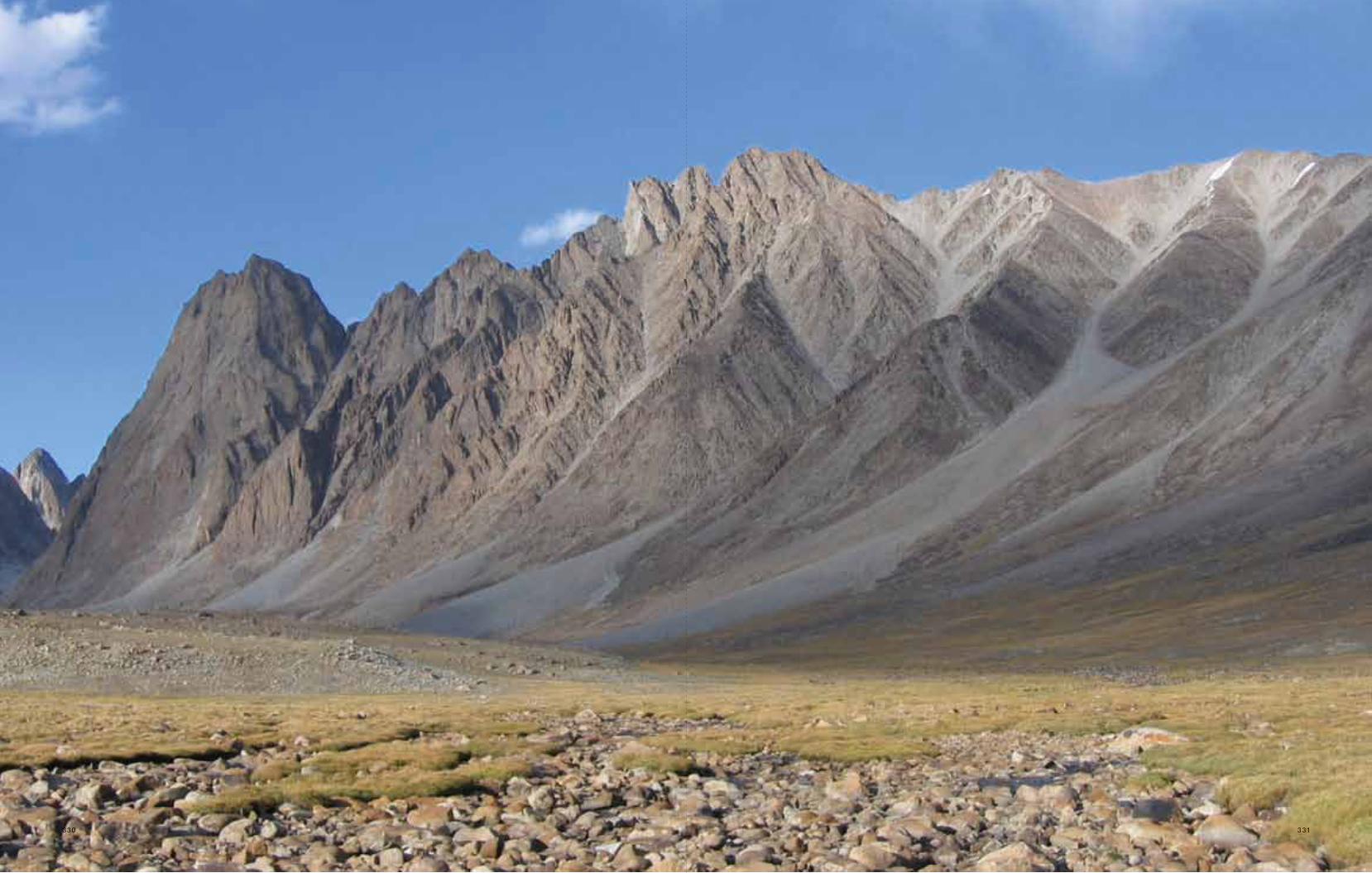
following pages, Barnaz pass, Little pamir — many petroglyph sites survive in remote areas of the mountain chain.
AKTC undertook a survey in the Wakhan and the Pamir areas in Badakhshan province, as part of wider efforts to document cultural and architectural heritage in Afghanistan. Building on earlier research work in this remote region, the survey has enabled the preparation of an inventory of one hundred sites, including petroglyphs, shrines, mosques, forts and burial structures, as well as examples of indigenous architecture. The results illustrate the rich built heritage of the area, and have enabled identifica-tion of sites that might be at risk from looting or natural deterioration. The inventory has been made available to the Ministry of Information and Culture and other relevant institutions in Afghanistan, for use in further research and possible conservation of key heritage sites. The inventory also contains material that could potentially con- tribute to the promotion of tourism and the safeguarding of heritage sites in the con-text of wider infrastructural development initiatives in the Wakhan and Pamirs.
BuiLt form And BuiLdinG tEcHniQuESThe form and construction techniques employed in the domestic vernacular archi-tecture of Afghanistan are influenced by environmental conditions, the availability of materials and building skills, as well as specific social practices. The most common form of dwelling in the Wakhan area is a series of rectangular rooms grouped around
328 329
BAdAKHSHAn NATURAL LANDSCAPES WAKHAN HERITAGE INVENTORY
330 331
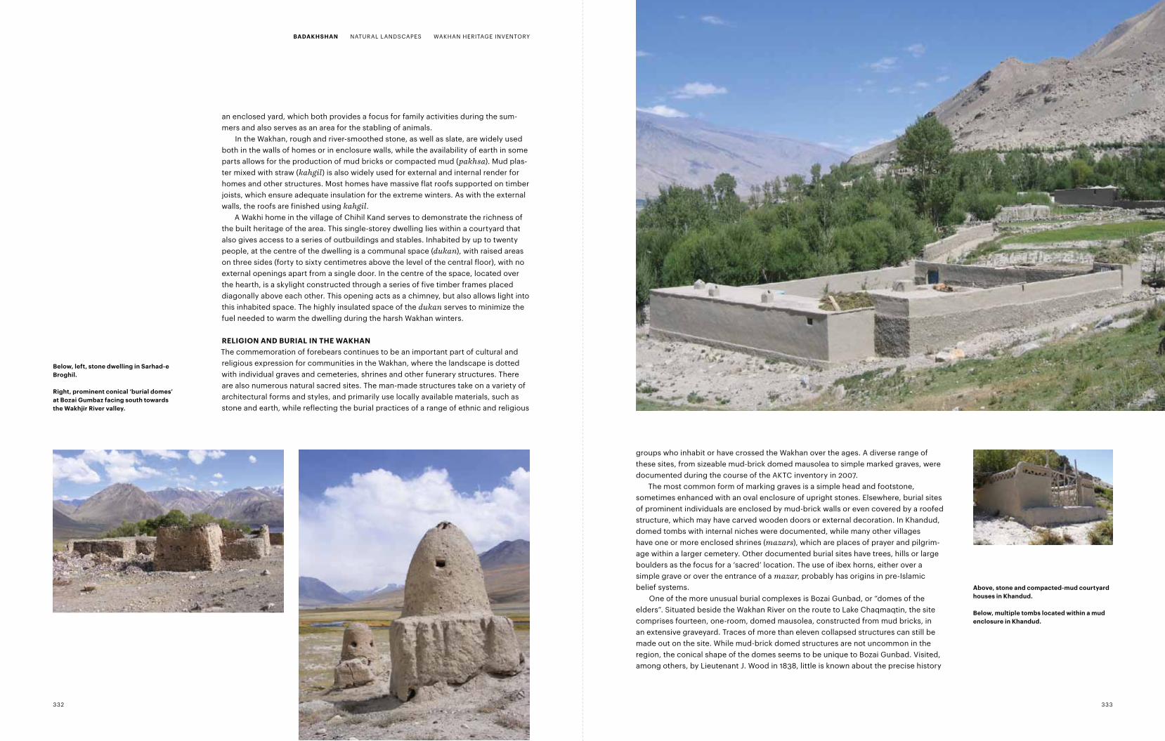
groups who inhabit or have crossed the Wakhan over the ages. A diverse range of these sites, from sizeable mud-brick domed mausolea to simple marked graves, were documented during the course of the AKTC inventory in 2007.
The most common form of marking graves is a simple head and footstone, sometimes enhanced with an oval enclosure of upright stones. Elsewhere, burial sites of prominent individuals are enclosed by mud-brick walls or even covered by a roofed structure, which may have carved wooden doors or external decoration. In Khandud, domed tombs with internal niches were documented, while many other villages have one or more enclosed shrines (mazars), which are places of prayer and pilgrim- age within a larger cemetery. Other documented burial sites have trees, hills or large boulders as the focus for a ‘sacred’ location. The use of ibex horns, either over a simple grave or over the entrance of a mazar, probably has origins in pre-Islamic belief systems.
One of the more unusual burial complexes is Bozai Gunbad, or “domes of the elders”. Situated beside the Wakhan River on the route to Lake Chaqmaqtin, the site comprises fourteen, one-room, domed mausolea, constructed from mud bricks, in an extensive graveyard. Traces of more than eleven collapsed structures can still be made out on the site. While mud-brick domed structures are not uncommon in the region, the conical shape of the domes seems to be unique to Bozai Gunbad. Visited, among others, by Lieutenant J. Wood in 1838, little is known about the precise history
an enclosed yard, which both provides a focus for family activities during the sum-mers and also serves as an area for the stabling of animals.
In the Wakhan, rough and river-smoothed stone, as well as slate, are widely used both in the walls of homes or in enclosure walls, while the availability of earth in some parts allows for the production of mud bricks or compacted mud (pakhsa). Mud plas-ter mixed with straw (kahgil) is also widely used for external and internal render for homes and other structures. Most homes have massive flat roofs supported on timber joists, which ensure adequate insulation for the extreme winters. As with the external walls, the roofs are finished using kahgil.
A Wakhi home in the village of Chihil Kand serves to demonstrate the richness of the built heritage of the area. This single-storey dwelling lies within a courtyard that also gives access to a series of outbuildings and stables. Inhabited by up to twenty people, at the centre of the dwelling is a communal space (dukan), with raised areas on three sides (forty to sixty centimetres above the level of the central floor), with no external openings apart from a single door. In the centre of the space, located over the hearth, is a skylight constructed through a series of five timber frames placed diagonally above each other. This opening acts as a chimney, but also allows light into this inhabited space. The highly insulated space of the dukan serves to minimize the fuel needed to warm the dwelling during the harsh Wakhan winters.
rELiGion And BuriAL in tHE WAKHAnThe commemoration of forebears continues to be an important part of cultural and religious expression for communities in the Wakhan, where the landscape is dotted with individual graves and cemeteries, shrines and other funerary structures. There are also numerous natural sacred sites. The man-made structures take on a variety of architectural forms and styles, and primarily use locally available materials, such as stone and earth, while reflecting the burial practices of a range of ethnic and religious
Below, left, stone dwelling in Sarhad-e Broghil.
right, prominent conical ‘burial domes’ at Bozai Gumbaz facing south towards the Wakhjir river valley.
Above, stone and compacted-mud courtyard houses in Khandud.
Below, multiple tombs located within a mud enclosure in Khandud.
332 333
BAdAKHSHAn NATURAL LANDSCAPES WAKHAN HERITAGE INVENTORY
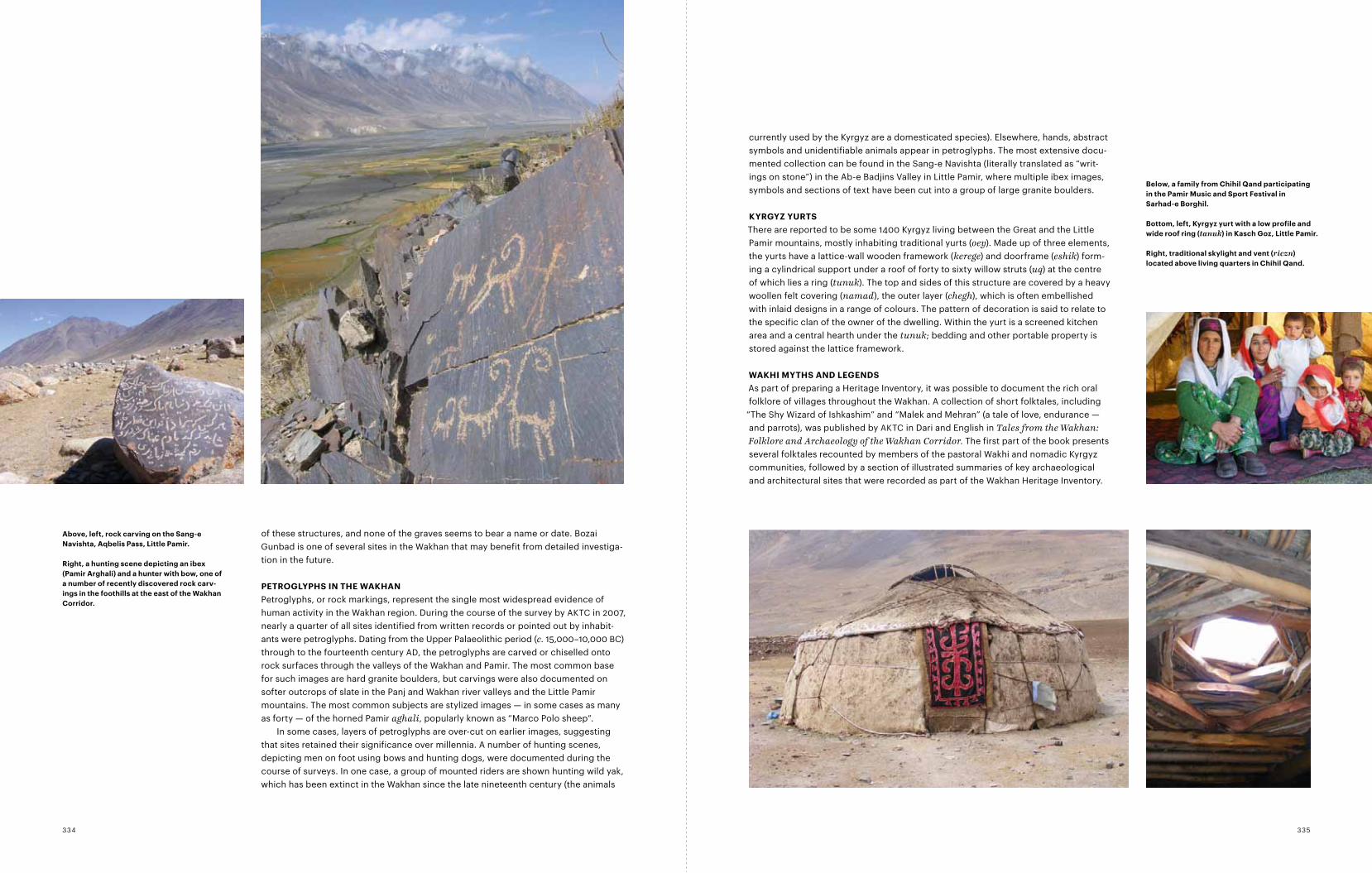
currently used by the Kyrgyz are a domesticated species). Elsewhere, hands, abstract symbols and unidentifiable animals appear in petroglyphs. The most extensive docu-mented collection can be found in the Sang-e Navishta (literally translated as “writ-ings on stone”) in the Ab-e Badjins Valley in Little Pamir, where multiple ibex images, symbols and sections of text have been cut into a group of large granite boulders.
KyrGyZ yurtSThere are reported to be some 1400 Kyrgyz living between the Great and the Little Pamir mountains, mostly inhabiting traditional yurts (oey). Made up of three elements, the yurts have a lattice-wall wooden framework (kerege) and doorframe (eshik) form-ing a cylindrical support under a roof of forty to sixty willow struts (uq) at the centre of which lies a ring (tunuk). The top and sides of this structure are covered by a heavy woollen felt covering (namad), the outer layer (chegh), which is often embellished with inlaid designs in a range of colours. The pattern of decoration is said to relate to the specific clan of the owner of the dwelling. Within the yurt is a screened kitchen area and a central hearth under the tunuk; bedding and other portable property is stored against the lattice framework.
WAKHi mytHS And LEGEndSAs part of preparing a Heritage Inventory, it was possible to document the rich oral folklore of villages throughout the Wakhan. A collection of short folktales, including
“The Shy Wizard of Ishkashim” and “Malek and Mehran” (a tale of love, endurance — and parrots), was published by AKTC in Dari and English in Tales from the Wakhan: Folklore and Archaeology of the Wakhan Corridor. The first part of the book presents several folktales recounted by members of the pastoral Wakhi and nomadic Kyrgyz communities, followed by a section of illustrated summaries of key archaeological and architectural sites that were recorded as part of the Wakhan Heritage Inventory.
of these structures, and none of the graves seems to bear a name or date. Bozai Gunbad is one of several sites in the Wakhan that may benefit from detailed investiga-tion in the future.
pEtroGLypHS in tHE WAKHAnPetroglyphs, or rock markings, represent the single most widespread evidence of human activity in the Wakhan region. During the course of the survey by AKTC in 2007, nearly a quarter of all sites identified from written records or pointed out by inhabit-ants were petroglyphs. Dating from the Upper Palaeolithic period (c. 15,000–10,000 BC) through to the fourteenth century AD, the petroglyphs are carved or chiselled onto rock surfaces through the valleys of the Wakhan and Pamir. The most common base for such images are hard granite boulders, but carvings were also documented on softer outcrops of slate in the Panj and Wakhan river valleys and the Little Pamir mountains. The most common subjects are stylized images — in some cases as many as forty — of the horned Pamir aghali, popularly known as “Marco Polo sheep”.
In some cases, layers of petroglyphs are over-cut on earlier images, suggesting that sites retained their significance over millennia. A number of hunting scenes, depicting men on foot using bows and hunting dogs, were documented during the course of surveys. In one case, a group of mounted riders are shown hunting wild yak, which has been extinct in the Wakhan since the late nineteenth century (the animals
Below, a family from chihil Qand participating in the pamir music and Sport festival in Sarhad-e Borghil.
Bottom, left, Kyrgyz yurt with a low profile and wide roof ring (tanuk) in Kasch Goz, Little pamir.
right, traditional skylight and vent (riczn) located above living quarters in chihil Qand.
Above, left, rock carving on the Sang-e navishta, Aqbelis pass, Little pamir.
right, a hunting scene depicting an ibex (pamir Arghali) and a hunter with bow, one of a number of recently discovered rock carv-ings in the foothills at the east of the Wakhan corridor.
335334
tHE cHALLEnGE of pLAnninG
BAdAKHSHAn
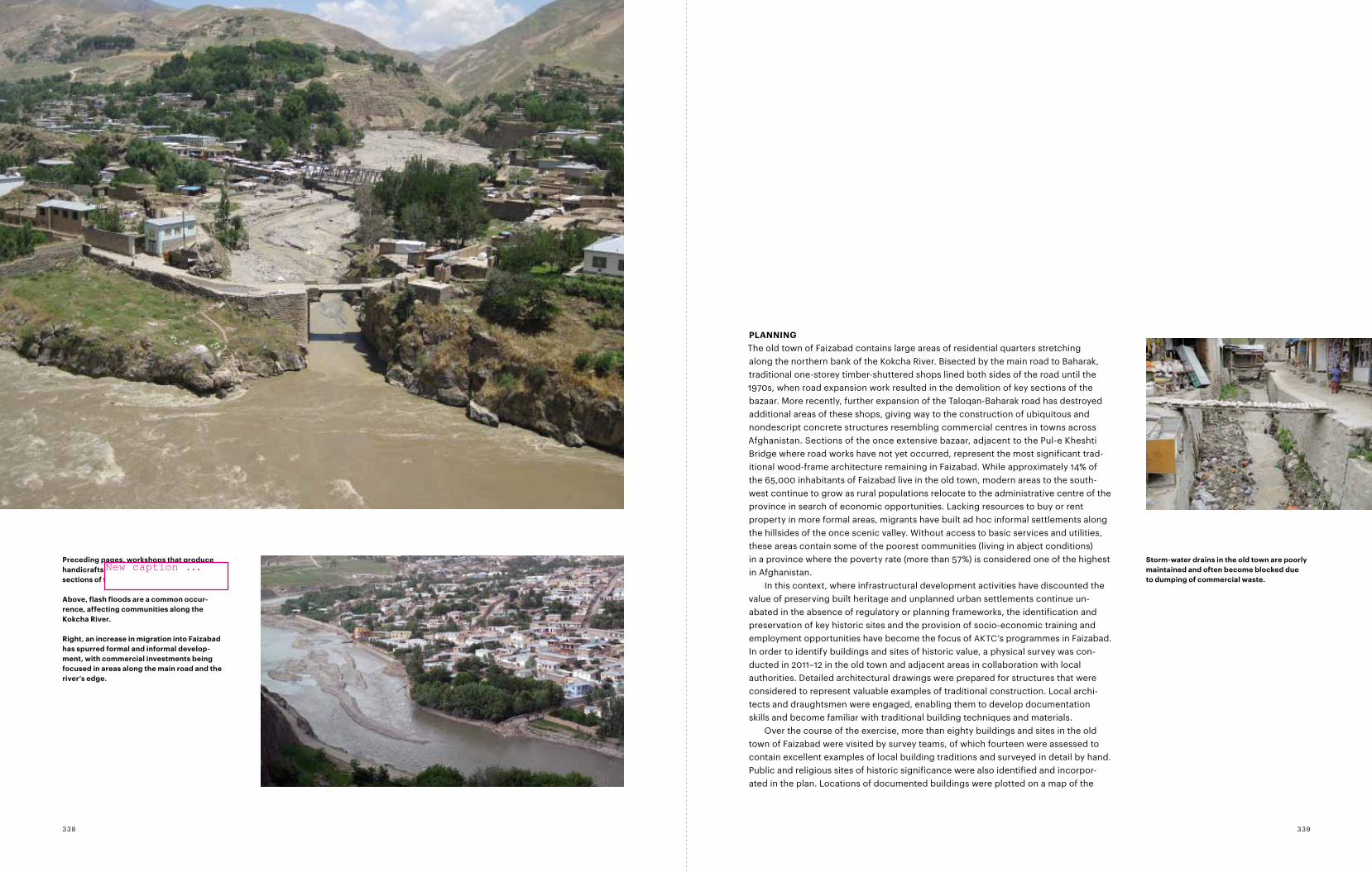
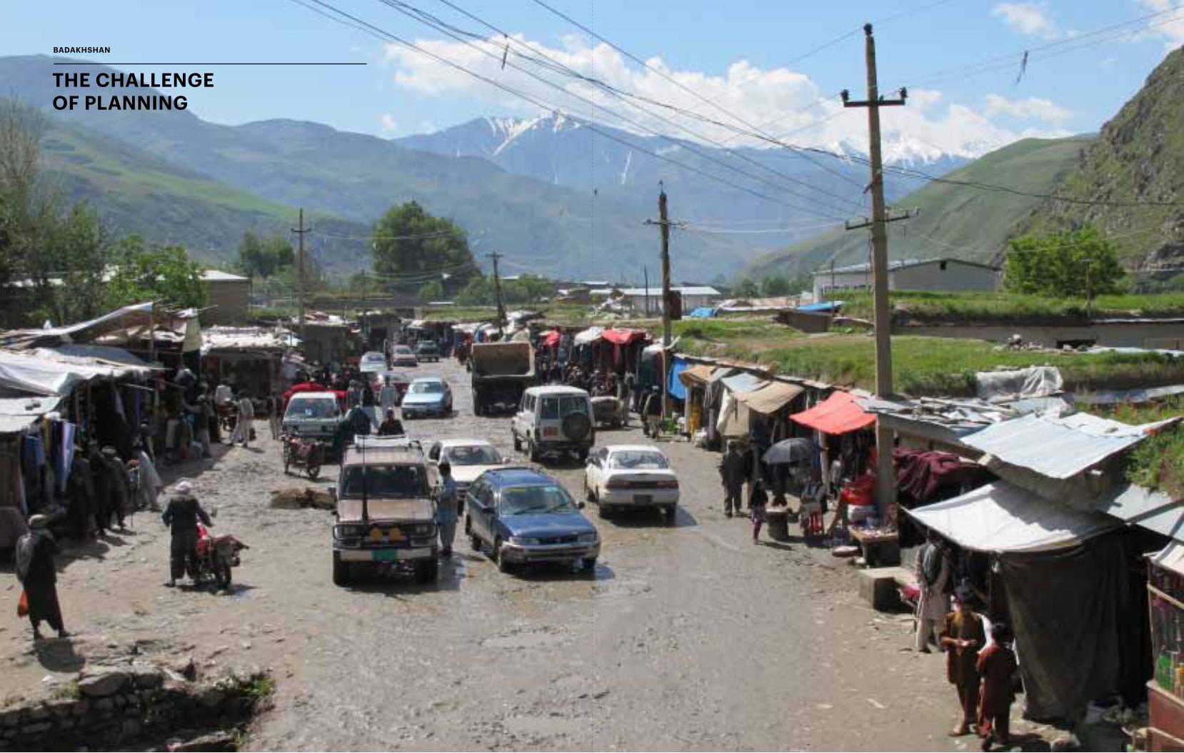
pLAnninGThe old town of Faizabad contains large areas of residential quarters stretching along the northern bank of the Kokcha River. Bisected by the main road to Baharak, traditional one-storey timber-shuttered shops lined both sides of the road until the 1970s, when road expansion work resulted in the demolition of key sections of the bazaar. More recently, further expansion of the Taloqan-Baharak road has destroyed additional areas of these shops, giving way to the construction of ubiquitous and nondescript concrete structures resembling commercial centres in towns across Afghanistan. Sections of the once extensive bazaar, adjacent to the Pul-e Kheshti Bridge where road works have not yet occurred, represent the most significant trad-itional wood-frame architecture remaining in Faizabad. While approximately 14% of the 65,000 inhabitants of Faizabad live in the old town, modern areas to the south-west continue to grow as rural populations relocate to the administrative centre of the province in search of economic opportunities. Lacking resources to buy or rent property in more formal areas, migrants have built ad hoc informal settlements along the hillsides of the once scenic valley. Without access to basic services and utilities, these areas contain some of the poorest communities (living in abject conditions) in a province where the poverty rate (more than 57%) is considered one of the highest in Afghanistan.
In this context, where infrastructural development activities have discounted the value of preserving built heritage and unplanned urban settlements continue un- abated in the absence of regulatory or planning frameworks, the identification and preservation of key historic sites and the provision of socio-economic training and employment opportunities have become the focus of AKTC’s programmes in Faizabad. In order to identify buildings and sites of historic value, a physical survey was con-ducted in 2011–12 in the old town and adjacent areas in collaboration with local authorities. Detailed architectural drawings were prepared for structures that were considered to represent valuable examples of traditional construction. Local archi-tects and draughtsmen were engaged, enabling them to develop documentation skills and become familiar with traditional building techniques and materials.
Over the course of the exercise, more than eighty buildings and sites in the old town of Faizabad were visited by survey teams, of which fourteen were assessed to contain excellent examples of local building traditions and surveyed in detail by hand. Public and religious sites of historic significance were also identified and incorpor-ated in the plan. Locations of documented buildings were plotted on a map of the
Storm-water drains in the old town are poorly maintained and often become blocked due to dumping of commercial waste.
preceding pages, workshops that produce handicrafts can still be found in the remaining sections of traditional shops in the old town.
Above, flash floods are a common occur-rence, affecting communities along the Kokcha river.
right, an increase in migration into faizabad has spurred formal and informal develop-ment, with commercial investments being focused in areas along the main road and the river’s edge.
339338
New caption ...
old town, enabling the survey team to identify larger clusters of traditional construc-tions and generate additional information on patterns of historic growth. Drawings prepared on the remaining sections of the traditional timber-shuttered shops formed part of wider documentation used to inscribe the buildings as registered national monuments. In addition to taking stock of Faizabad’s remaining heritage, physical surveys enabled the formulation of detailed designs for the restoration of key sites in urgent need of repair. Surveys and ongoing physical conservation activities are conducted jointly with local authorities and the community, who actively participate in identifying priorities and supporting implementation of projects.
In parallel with the physical documentation of heritage sites in Faizabad, AKTC carried out an extensive socio-economic Quality of Life Assessment survey in 2011 with a sample size of approximately eight hundred households or 15% of the population in the town. The survey covered all municipal districts of Faizabad includ-ing the old town, planned residential areas to the west and informal hillside settle-ments. The findings of the survey were partially encouraging, highlighting areas where significant progress had been made (education rates and home ownership) and others where further support was required (employment generation, upgrading of public services, provision of healthcare and environmental improvements). The average family size (7.5) was made up mainly of those under eighteen years of age (50% of the population), who, together with others of working age (15–64), contribut- ed towards providing subsistence (dependency ratio of 73) for their families. While Faizabad has established one of the highest youth literary rates (86%) in Afghanistan (national average 39%), the town is significantly behind in labour force participa-tion (36%) as compared to the national average (67%), that is, those aged fifteen or above who are economically active. The division in participation in the labour work-force is particularly acute between men (61%) and women (12%). More than 67% of the respondents indicated that they lived in ‘fair’ conditions, with a further 24% describing their living conditions as ‘poor to very bad’. Furthermore, approximately 80% of the population obtains its potable water from public shallow wells, which
are vulnerable to contamination from household waste (98% of which is deposited on open ground or in the river). Respondents (94%) also pointed out a lack of public green space and safe areas for children to play.
The findings of the Faizabad socio-economic survey provided important baseline information on the livelihood and living conditions of the population and enabled the planning and implementation of a multi-year conservation programme aimed at creating employment and training for local youth, particularly women, in trades that help generate sustainable income for households. Additional focus was placed on rehabilitating public open spaces, particularly parks and gardens, which provided safe environments for children and families.
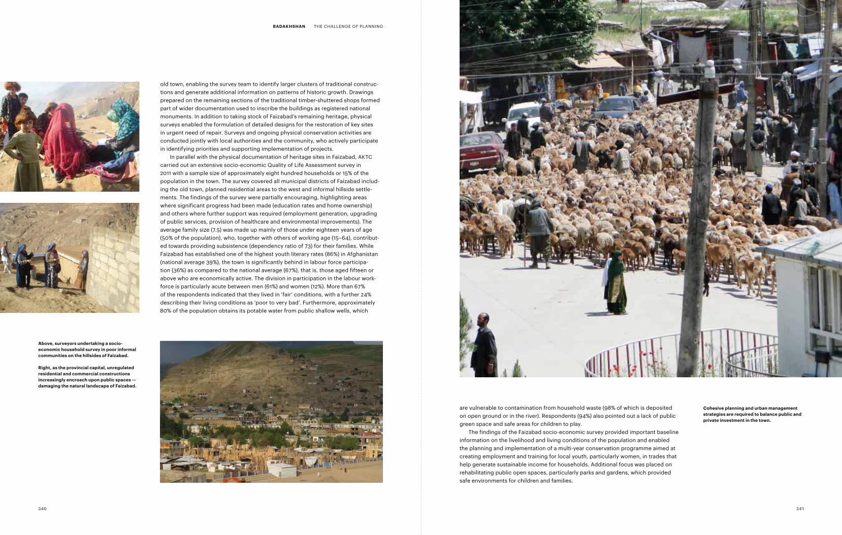
Above, surveyors undertaking a socio-economic household survey in poor informal communities on the hillsides of faizabad.
right, as the provincial capital, unregulated residential and commercial constructions increasingly encroach upon public spaces — damaging the natural landscape of faizabad.
cohesive planning and urban management strategies are required to balance public and private investment in the town.
340 341
BAdAKHSHAn THE CHALLENGE OF PLANNING