BACKGROUND, HISTORY AND STATUS OF … Visiting Lecturers/WangKun02.pdfLECTURE 2 BACKGROUND, HISTORY...
10
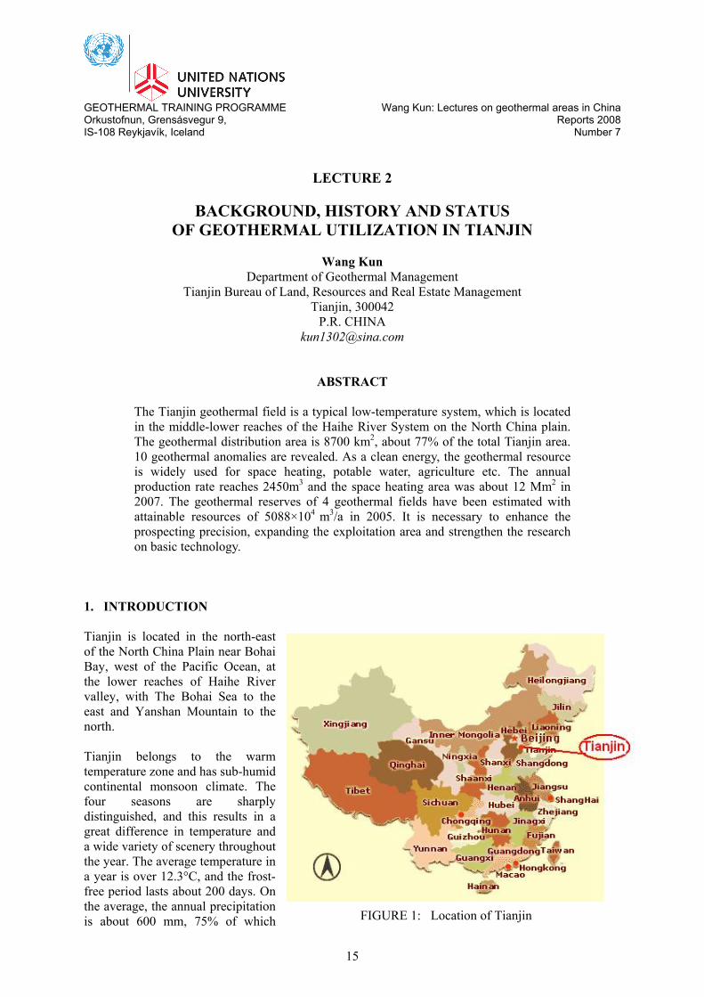
GEOTHERMAL TRAINING PROGRAMME Wang Kun: Lectures on geothermal areas in China Orkustofnun, Grensásvegur 9, Reports 2008 IS-108 Reykjavík, Iceland Number 7 15 LECTURE 2 BACKGROUND, HISTORY AND STATUS OF GEOTHERMAL UTILIZATION IN TIANJIN Wang Kun Department of Geothermal Management Tianjin Bureau of Land, Resources and Real Estate Management Tianjin, 300042 P.R. CHINA [email protected] ABSTRACT The Tianjin geothermal field is a typical low-temperature system, which is located in the middle-lower reaches of the Haihe River System on the North China plain. The geothermal distribution area is 8700 km 2 , about 77% of the total Tianjin area. 10 geothermal anomalies are revealed. As a clean energy, the geothermal resource is widely used for space heating, potable water, agriculture etc. The annual production rate reaches 2450m 3 and the space heating area was about 12 Mm 2 in 2007. The geothermal reserves of 4 geothermal fields have been estimated with attainable resources of 5088×10 4 m 3 /a in 2005. It is necessary to enhance the prospecting precision, expanding the exploitation area and strengthen the research on basic technology. 1. INTRODUCTION Tianjin is located in the north-east of the North China Plain near Bohai Bay, west of the Pacific Ocean, at the lower reaches of Haihe River valley, with The Bohai Sea to the east and Yanshan Mountain to the north. Tianjin belongs to the warm temperature zone and has sub-humid continental monsoon climate. The four seasons are sharply distinguished, and this results in a great difference in temperature and a wide variety of scenery throughout the year. The average temperature in a year is over 12.3°C, and the frost- free period lasts about 200 days. On the average, the annual precipitation is about 600 mm, 75% of which FIGURE 1: Location of Tianjin
Transcript of BACKGROUND, HISTORY AND STATUS OF … Visiting Lecturers/WangKun02.pdfLECTURE 2 BACKGROUND, HISTORY...
GEOTHERMAL TRAINING PROGRAMME Wang Kun: Lectures on geothermal areas in China Orkustofnun, Grensásvegur 9, Reports 2008 IS-108 Reykjavík, Iceland Number 7
15
LECTURE 2
BACKGROUND, HISTORY AND STATUS OF GEOTHERMAL UTILIZATION IN TIANJIN
Wang Kun
Department of Geothermal Management Tianjin Bureau of Land, Resources and Real Estate Management
Tianjin, 300042 P.R. CHINA
ABSTRACT
The Tianjin geothermal field is a typical low-temperature system, which is located in the middle-lower reaches of the Haihe River System on the North China plain. The geothermal distribution area is 8700 km2, about 77% of the total Tianjin area. 10 geothermal anomalies are revealed. As a clean energy, the geothermal resource is widely used for space heating, potable water, agriculture etc. The annual production rate reaches 2450m3 and the space heating area was about 12 Mm2 in 2007. The geothermal reserves of 4 geothermal fields have been estimated with attainable resources of 5088×104 m3/a in 2005. It is necessary to enhance the prospecting precision, expanding the exploitation area and strengthen the research on basic technology.
1. INTRODUCTION Tianjin is located in the north-east of the North China Plain near Bohai Bay, west of the Pacific Ocean, at the lower reaches of Haihe River valley, with The Bohai Sea to the east and Yanshan Mountain to the north. Tianjin belongs to the warm temperature zone and has sub-humid continental monsoon climate. The four seasons are sharply distinguished, and this results in a great difference in temperature and a wide variety of scenery throughout the year. The average temperature in a year is over 12.3°C, and the frost-free period lasts about 200 days. On the average, the annual precipitation is about 600 mm, 75% of which FIGURE 1: Location of Tianjin
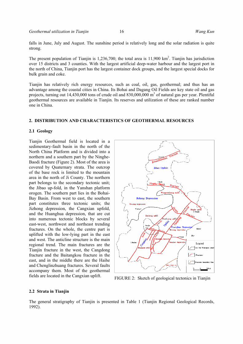
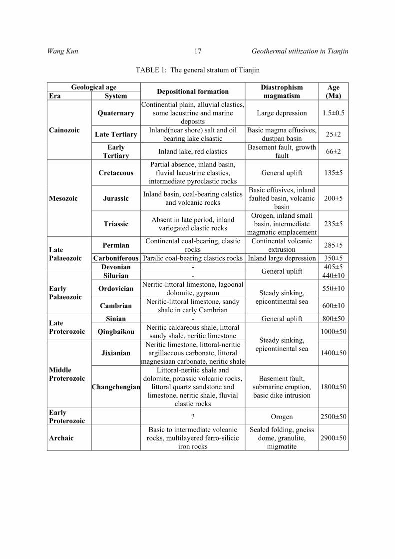
Geothermal utilization in Tianjin 16 Wang Kun falls in June, July and August. The sunshine period is relatively long and the solar radiation is quite strong. The present population of Tianjin is 1,236,700; the total area is 11,900 km2. Tianjin has jurisdiction over 15 districts and 3 counties. With the largest artificial deep-water harbour and the largest port in the north of China, Tianjin port has the largest container dock groups, and the largest special docks for bulk grain and coke. Tianjin has relatively rich energy resources, such as coal, oil, gas, geothermal; and thus has an advantage among the coastal cities in China. Its Bohai and Dagang Oil Fields are key state oil and gas projects, turning out 14,430,000 tons of crude oil and 830,000,000 m3 of natural gas per year. Plentiful geothermal resources are available in Tianjin. Its reserves and utilization of these are ranked number one in China. 2. DISTRIBUTION AND CHARACTERISTICS OF GEOTHERMAL RESOURCES 2.1 Geology Tianjin Geothermal field is located in a sedimentary-fault basin in the north of the North China Platform and is divided into a northern and a southern part by the Ninghe-Baodi fracture (Figure 2). Most of the area is covered by Quaternary strata. The outcrop of the base rock is limited to the mountain area in the north of Ji County. The northern part belongs to the secondary tectonic unit; the Jibao up-fold, in the Yanshan platform orogen. The southern part lies in the Bohai-Bay Basin. From west to east, the southern part constitutes three tectonic units; the Jizhong depression, the Cangxian upfold, and the Huanghua depression, that are cut into numerous tectonic blocks by several east-west, northwest and northeast trending fractures. On the whole, the centre part is uplifted with the low-lying part in the east and west. The anticline structure is the main regional trend. The main fractures are the Tianjin fracture in the west, the Cangdong fracture and the Baitangkou fracture in the east, and in the middle there are the Haihe and Chenglinzhuang fractures. Several faults accompany them. Most of the geothermal fields are located in the Cangxian uplift. 2.2 Strata in Tianjin The general stratigraphy of Tianjin is presented in Table 1 (Tianjin Regional Geological Records, 1992).
FIGURE 2: Sketch of geological tectonics in Tianjin
Wang Kun 17 Geothermal utilization in Tianjin
TABLE 1: The general stratum of Tianjin
Geological age Depositional formation Diastrophism magmatism
Age (Ma) Era System
Cainozoic
Quaternary Continential plain, alluvial clastics,
some lacustrine and marine deposits
Large depression 1.5±0.5
Late Tertiary Inland(near shore) salt and oil bearing lake clsastic
Basic magma effusives, dustpan basin 25±2
Early Tertiary Inland lake, red clastics Basement fault, growth
fault 66±2
Mesozoic
Cretaceous Partial absence, inland basin,
fluvial lacustrine clastics, intermediate pyroclastic rocks
General uplift 135±5
Jurassic Inland basin, coal-bearing calstics and volcanic rocks
Basic effusives, inland faulted basin, volcanic
basin 200±5
Triassic Absent in late period, inland variegated clastic rocks
Orogen, inland small basin, intermediate
magmatic emplacement 235±5
Late Palaeozoic
Permian Continental coal-bearing, clastic rocks
Continental volcanic extrusion 285±5
Carboniferous Paralic coal-bearing clastics rocks Inland large depression 350±5 Devonian - General uplift 405±5
Early Palaeozoic
Silurian - 440±10
Ordovician Neritic-littoral limestone, lagoonal dolomite, gypsum Steady sinking,
epicontinental sea
550±10
Cambrian Neritic-littoral limestone, sandy shale in early Cambrian 600±10
Late Proterozoic
Sinian - General uplift 800±50
Qingbaikou Neritic calcareous shale, littoral sandy shale, neritic limestone Steady sinking,
epicontinental sea
1000±50
Middle Proterozoic
Jixianian Neritic limestone, littoral-neritic argillaccous carbonate, littoral
magnesiaan carbonate, neritic shale1400±50
Changchengian
Littoral-neritic shale and dolomite, potassic volcanic rocks,
littoral quartz sandstone and limestone, neritic shale, fluvial
clastic rocks
Basement fault, submarine eruption, basic dike intrusion
1800±50
Early Proterozoic ? Orogen 2500±50
Archaic Basic to intermediate volcanic rocks, multilayered ferro-silicic
iron rocks
Sealed folding, gneiss dome, granulite,
migmatite 2900±50

Geothermal utilization in Tianjin 18 Wang Kun 2.3 Distribution of geothermal fields in Tianjin There are 10 geothermal anomaly areas in Tianjin determined by temperature gradients of 3.5°C/100m (Figure 3). Seven of them are distributed in the Cangxian Up-fold. In Table 2 the temperature gradients of the cap rocks area are shown.
TABLE 2: Geothemal anomalies in Tianjin
Geothemal anomalies
Area (km2)
Highest temperature gradients of cap rock (°C / 100m)
Wang Lanzhuang 534 8.0 Shanglingzi 315 8.3
Wanjia Matou 235 8.8 Pan zhuang 610 6.9
Zhouliangzhuang 180 5.5 Qiaogu 90 5.5
Kancaizhuang 20 5.5 Wangqingtuo 114 5.0
Shajingzi 190 4.5 Tangguantun 40 7.6
FIGURE 3: The location of geothermal anomaly areas in Tianjin
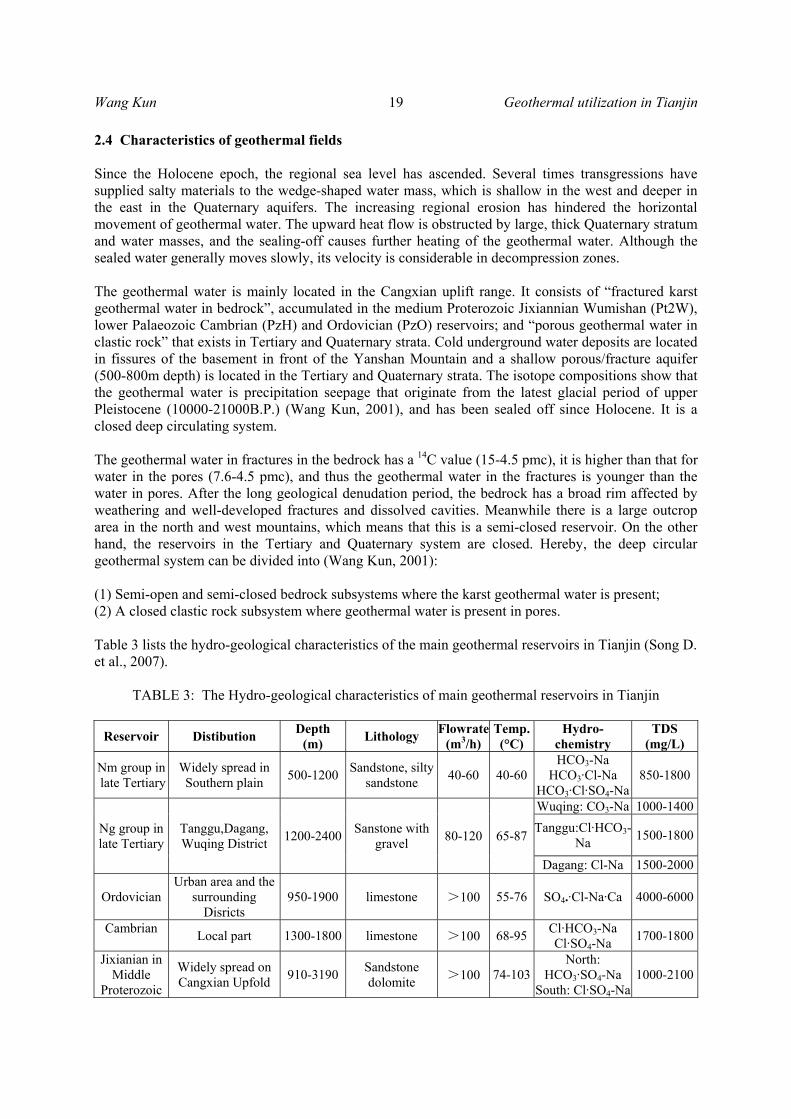
Wang Kun 19 Geothermal utilization in Tianjin 2.4 Characteristics of geothermal fields Since the Holocene epoch, the regional sea level has ascended. Several times transgressions have supplied salty materials to the wedge-shaped water mass, which is shallow in the west and deeper in the east in the Quaternary aquifers. The increasing regional erosion has hindered the horizontal movement of geothermal water. The upward heat flow is obstructed by large, thick Quaternary stratum and water masses, and the sealing-off causes further heating of the geothermal water. Although the sealed water generally moves slowly, its velocity is considerable in decompression zones. The geothermal water is mainly located in the Cangxian uplift range. It consists of “fractured karst geothermal water in bedrock”, accumulated in the medium Proterozoic Jixiannian Wumishan (Pt2W), lower Palaeozoic Cambrian (PzH) and Ordovician (PzO) reservoirs; and “porous geothermal water in clastic rock” that exists in Tertiary and Quaternary strata. Cold underground water deposits are located in fissures of the basement in front of the Yanshan Mountain and a shallow porous/fracture aquifer (500-800m depth) is located in the Tertiary and Quaternary strata. The isotope compositions show that the geothermal water is precipitation seepage that originate from the latest glacial period of upper Pleistocene (10000-21000B.P.) (Wang Kun, 2001), and has been sealed off since Holocene. It is a closed deep circulating system. The geothermal water in fractures in the bedrock has a 14C value (15-4.5 pmc), it is higher than that for water in the pores (7.6-4.5 pmc), and thus the geothermal water in the fractures is younger than the water in pores. After the long geological denudation period, the bedrock has a broad rim affected by weathering and well-developed fractures and dissolved cavities. Meanwhile there is a large outcrop area in the north and west mountains, which means that this is a semi-closed reservoir. On the other hand, the reservoirs in the Tertiary and Quaternary system are closed. Hereby, the deep circular geothermal system can be divided into (Wang Kun, 2001): (1) Semi-open and semi-closed bedrock subsystems where the karst geothermal water is present; (2) A closed clastic rock subsystem where geothermal water is present in pores. Table 3 lists the hydro-geological characteristics of the main geothermal reservoirs in Tianjin (Song D. et al., 2007).
TABLE 3: The Hydro-geological characteristics of main geothermal reservoirs in Tianjin
Reservoir Distibution Depth (m) Lithology Flowrate
(m3/h) Temp.(°C)
Hydro-chemistry
TDS (mg/L)
Nm group in late Tertiary
Widely spread in Southern plain 500-1200 Sandstone, silty
sandstone 40-60 40-60HCO3-Na
HCO3·Cl-Na HCO3·Cl·SO4-Na
850-1800
Ng group in late Tertiary
Tanggu,Dagang, Wuqing District 1200-2400 Sanstone with
gravel 80-120 65-87
Wuqing: CO3-Na 1000-1400Tanggu:Cl·HCO3-
Na 1500-1800
Dagang: Cl-Na 1500-2000
Ordovician Urban area and the
surrounding Disricts
950-1900 limestone >100 55-76 SO4•·Cl-Na·Ca 4000-6000
Cambrian Local part 1300-1800 limestone >100 68-95 Cl·HCO3-Na Cl·SO4-Na 1700-1800
Jixianian in Middle
Proterozoic
Widely spread on Cangxian Upfold 910-3190 Sandstone
dolomite >100 74-103North:
HCO3·SO4-Na South: Cl·SO4-Na
1000-2100
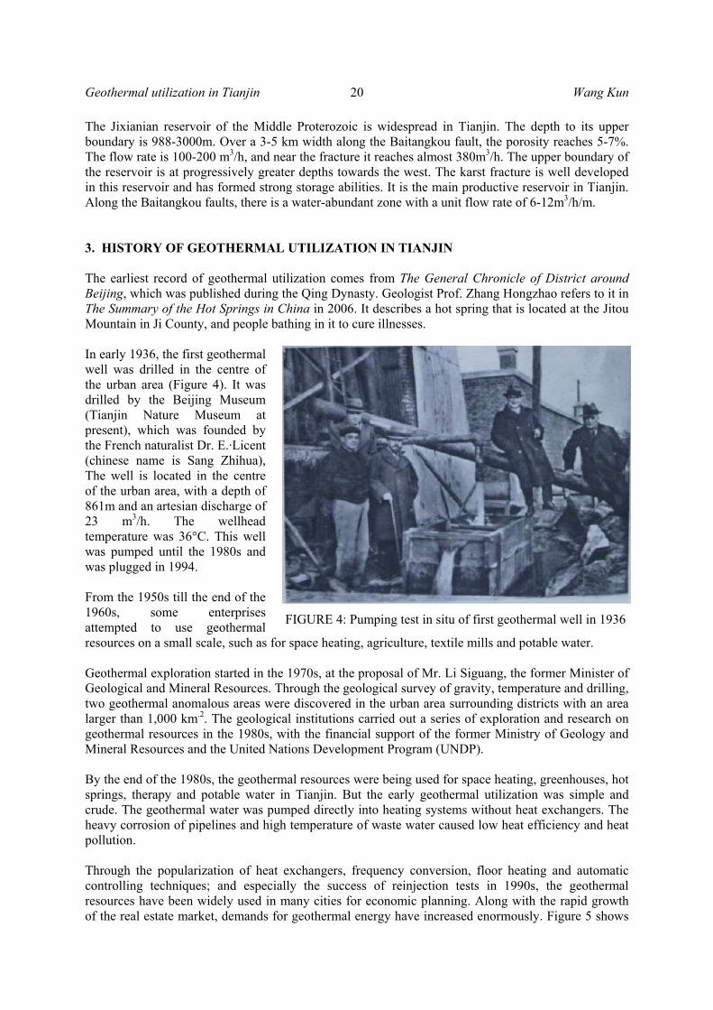
Geothermal utilization in Tianjin 20 Wang Kun The Jixianian reservoir of the Middle Proterozoic is widespread in Tianjin. The depth to its upper boundary is 988-3000m. Over a 3-5 km width along the Baitangkou fault, the porosity reaches 5-7%. The flow rate is 100-200 m3/h, and near the fracture it reaches almost 380m3/h. The upper boundary of the reservoir is at progressively greater depths towards the west. The karst fracture is well developed in this reservoir and has formed strong storage abilities. It is the main productive reservoir in Tianjin. Along the Baitangkou faults, there is a water-abundant zone with a unit flow rate of 6-12m3/h/m. 3. HISTORY OF GEOTHERMAL UTILIZATION IN TIANJIN The earliest record of geothermal utilization comes from The General Chronicle of District around Beijing, which was published during the Qing Dynasty. Geologist Prof. Zhang Hongzhao refers to it in The Summary of the Hot Springs in China in 2006. It describes a hot spring that is located at the Jitou Mountain in Ji County, and people bathing in it to cure illnesses. In early 1936, the first geothermal well was drilled in the centre of the urban area (Figure 4). It was drilled by the Beijing Museum (Tianjin Nature Museum at present), which was founded by the French naturalist Dr. E.·Licent (chinese name is Sang Zhihua), The well is located in the centre of the urban area, with a depth of 861m and an artesian discharge of 23 m3/h. The wellhead temperature was 36°C. This well was pumped until the 1980s and was plugged in 1994. From the 1950s till the end of the 1960s, some enterprises attempted to use geothermal resources on a small scale, such as for space heating, agriculture, textile mills and potable water. Geothermal exploration started in the 1970s, at the proposal of Mr. Li Siguang, the former Minister of Geological and Mineral Resources. Through the geological survey of gravity, temperature and drilling, two geothermal anomalous areas were discovered in the urban area surrounding districts with an area larger than 1,000 km.2. The geological institutions carried out a series of exploration and research on geothermal resources in the 1980s, with the financial support of the former Ministry of Geology and Mineral Resources and the United Nations Development Program (UNDP). By the end of the 1980s, the geothermal resources were being used for space heating, greenhouses, hot springs, therapy and potable water in Tianjin. But the early geothermal utilization was simple and crude. The geothermal water was pumped directly into heating systems without heat exchangers. The heavy corrosion of pipelines and high temperature of waste water caused low heat efficiency and heat pollution. Through the popularization of heat exchangers, frequency conversion, floor heating and automatic controlling techniques; and especially the success of reinjection tests in 1990s, the geothermal resources have been widely used in many cities for economic planning. Along with the rapid growth of the real estate market, demands for geothermal energy have increased enormously. Figure 5 shows
FIGURE 4: Pumping test in situ of first geothermal well in 1936
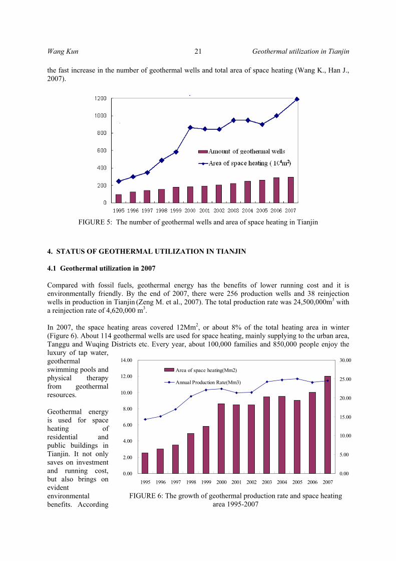
Wang Kun 21 Geothermal utilization in Tianjin the fast increase in the number of geothermal wells and total area of space heating (Wang K., Han J., 2007).
4. STATUS OF GEOTHERMAL UTILIZATION IN TIANJIN 4.1 Geothermal utilization in 2007 Compared with fossil fuels, geothermal energy has the benefits of lower running cost and it is environmentally friendly. By the end of 2007, there were 256 production wells and 38 reinjection wells in production in Tianjin (Zeng M. et al., 2007). The total production rate was 24,500,000m3 with a reinjection rate of 4,620,000 m3. In 2007, the space heating areas covered 12Mm2, or about 8% of the total heating area in winter (Figure 6). About 114 geothermal wells are used for space heating, mainly supplying to the urban area, Tanggu and Wuqing Districts etc. Every year, about 100,000 families and 850,000 people enjoy the luxury of tap water, geothermal swimming pools and physical therapy from geothermal resources.
Geothermal energy is used for space heating of residential and public buildings in Tianjin. It not only saves on investment and running cost, but also brings on evident environmental benefits. According
FIGURE 5: The number of geothermal wells and area of space heating in Tianjin
0.00
2.00
4.00
6.00
8.00
10.00
12.00
14.00
1995 1996 1997 1998 1999 2000 2001 2002 2003 2004 2005 2006 20070.00
5.00
10.00
15.00
20.00
25.00
30.00
Area of space heating(Mm2)
Annual Production Rate(Mm3)
FIGURE 6: The growth of geothermal production rate and space heating area 1995-2007

Geothermal utilization in Tianjin 22 Wang Kun to incomplete statistics, the extent of geothermal space heating corresponds to replacing 215,600 tons of standard coal, reducing the discharge of coal dust by 1552 tons, sulphur dioxide by 6653 tons nitrogen dioxide by 1996.3 tons and carbon monoxide by 171,400 m3. 4.2 Contribution of geothermal resources to local economic cooperation and development China has a rich traditional hot spring culture, which makes geothermal resources one of the unique opportunities for recreational projects. In recent years, real estate and tourism have developed rapidly in Tianjin. The exploration and development of geothermal resources attract investment in hot spring vacation resort projects. Some large scale construction projects are under construction. For example, the Zhouliangzhuang geothermal field is located in Baodi District, where there used to be deserted salty lands. There were only few farms and one village located there. As a result of the geothermal exploration, the first geothermal well was drilled in 2002 with a natural flow rate of 380m3/h. The wellhead temperature is 103°C, and the artesian pressure is 4 Mpa. Now, a new town called Zhujiang Hot Spring Town has developed there. The total investment will be more than $140 millions. In 2007, the construction area reached 60 km2 with a planned population of 200,000 inhabitants. The Hot Spring Town integrates the projects of villa construction, tourism, resorts, and convention and exhibition Centres. Two Universities have set up branches in the Town and started to recruit students in the summer of 2007.
The governments of China and Singapore signed the agreement for the Sino-Singapore Eco-City project. The Sino-Singapore Eco City is located between the Tanggu and Hangu Districts of Tianjin's Binhai New Area. It is the second cooperation project after the Suzhou Industry Garden between
FIGURE 7: Geothermal utilization in Tianjin
Wang Kun 23 Geothermal utilization in Tianjin China and Singapore, occupying an area of 32 km2. The construction will begin in July 2008 and will end in 2010. The maximum investment is estimated to be $4300 million. When completed, there will be 300,000 residents living and working in energy-efficient buildings in the Eco City. Besides preservation and restoration of natural ecology, green consumption and low carbon emissions, it is social cohesion that tops the list of features for the eco-city. The geothermal exploration and utilization have been planned. 5. CONCLUSIONS The exploration and development of geothermal resources have played an important role in many aspects of Tianjin’s economical development, such as attracting investment, improving environmental quality and standard of living, expanding tourism and developing industrial and agricultural production. Geothermal utilization brings about remarkable economic, social and environmental benefits, The Tianjin Municipality puts great emphasis on geothermal resource management. The Geothermal Resources Development and Utilization Plan for Tianjin (2006-2010) were published in 2005. To meet the rapid increase in demand for geothermal resources, it is necessary to enhance the geothermal exploitation and strengthen the research on reinjection into the Tertiary system and the basement reservoir.
REFERENCES Song, D., Wang K., Xu P. et al., 2007: The annual of the Mineral Resources in Tianjin. Tianjin Bureau of Land Resources and Housing Administrative, 43 pp. Tianjin Bureau of Geology, 1992: Tianjin regional geological records. Geology Press, Beijing. Wang K., Lee C., and Lei H., 2005: The sustainable development and utilization of geothermal resources in Tianjin, China. Proceedings of the World Geothermal Congress 2005, Antalya, Turkey, CD, 14 pp. Wang, K., and Han, J., 2007: Demonstration projects on geothermal reinjection and cascade utilization in Tianjin. Transactions of the Workshop of Development and Protection of Geothermal Resources in China, 121-127. Wang, K., 2001: Application of isotopic technique on establishing hydrothermal concept model. J. of Science in China, 4. Zeng, M., Ruan, C., et al., 2007: The annual report of dynamic monitoring of geothermal resource in Tianjin. Tianjin Bureau of Land Resources and Housing Administrative, report (in Chinese).

Geothermal utilization in Tianjin 24 Wang Kun