
BACHELOR S THESIS - brage.bibsys.no¶derberg, F... · BACHELOR’S THESIS Contract Hovedoppgave i...
71
BACHELOR’S THESIS Postadresse Besøksadresse Telefon Telefax Bankkonto Høgskolen i Ålesund Larsgårdsvegen 2 70 16 12 00 70 16 13 00 7694 05 00636 N-6025 Ålesund Internett Epostadresse Foretaksregisteret Norway www.hials.no [email protected] NO 971 572 140
Transcript of BACHELOR S THESIS - brage.bibsys.no¶derberg, F... · BACHELOR’S THESIS Contract Hovedoppgave i...

BACHELOR’S THESIS
Postadresse Besøksadresse Telefon Telefax Bankkonto Høgskolen i Ålesund Larsgårdsvegen 2 70 16 12 00 70 16 13 00 7694 05 00636 N-6025 Ålesund Internett Epostadresse Foretaksregisteret Norway www.hials.no [email protected] NO 971 572 140

BACHELOR’S THESIS
Publishing agreement

BACHELOR’S THESIS
Group declaration

BACHELOR’S THESIS
Contract
Hovedoppgave i Nautikk våren 2015
For 2315, 2320, 2337
Dagens og fremtidens behov og utfordringer for kommunikasjon i nordområdene. Olje og gass industrien beveger seg stadig mer nordover med mer avansert teknologi for utvinning. Øvrig
trafikk innenfor fiske, turisme, forskning og befraktning øker da teknologi og is-flyttingen gjør dette mulig i
tillegg til behovet for ressurser og forskning. Vi har derfor valgt å undersøke begrensningene og mulighetene
for kommunikasjon i dette området med et fokus på olje og gass sektoren.
-Nordområdene idag. Definere området, hvordan ser trafikk situasjonen ut , hva slags trafikk, aktivitet
finnes og hvilke utstyr og tjänstbehov finner vi i dette området.
-Kommunikasjon. Beskrive satellittene og deres utfordringer i dette området. Aktører som leverer tjenester
og andre tjenester enn satellitter.
- Fremtiden i nordområdene. Få informasjon fra næringslivet og forskningsinstitutt. Igjen med fokus på olje
og gass sektoren som vi ser som mest aktuelle.
- Planlagte løsninger for kommunikasjonen. En oversikt over hva de ulike aktørene vil gjøre.
-Mulige løsninger for kommunikasjons problemene fra et forsknings perspektiv som de kommersielle
selskapene ikke dekker ennå.
Vi skal samle relevante data og materiale fra artikler, rapporter og undersøkelser. I tillegg vil vi subsidiere
den informasjonen vi samler inn med diskusjoner med næringslivet og fra personer som forsker på dette
området. Vi vil også samle inn data gjennom intervjuer fra aktører som bruker satellittkommunikasjon på
daglig basis i nordområdene idag. Dette vil bearbeides og komme frem i besvarelsen som en egen individuell
del hvor dette senere blir sammenlignet med det vi har funnet ut i en drøftingsdel. Besvarelsen vil utarbeides
på engelsk og redigeres mest mulig som en forskningsrapport med sammendrag, konklusjon, referanseliste
etc. Oppgavens omfang skal reflektere en arbeidsbelastning på cirka 12 studiepoeng for hver av studentene.
Endelig besvarelse skal leveres i 3 eksemplarer til HIÅ`s sekretariat senest 1.Juni 2015 og det skal legges opp
til individuell presentasjon i plenum omkring 1. juni. 2015.
HIÅ forbeholder seg retten til fritt å kunne benytte oppgaven i undervisning og utviklingsarbeid.
Tron Richard Resnes, veileder Ålesund, des. 2015

BACHELOR’S THESIS
Foreword The idea for the bachelor’s thesis was originally sketched in November 2014 and the final product was
submitted in May 2015. In these 6 months we have learned a lot about the different technologies and gained
understanding about the needs the vessels and installations operating in the Arctic have. Working in a team
of three has taught us a lot about team work and how to give constructive criticism to each other without
ruining friendship. It has been a journey of discovery, and we can all say that we are extremely happy with
the end result.
The process of collecting reliable data from various sources have been demanding as service providers have
a product they want to sell. In addition there is a sea full of service providers, some utilizing the same
satellites. The process of picking the most relevant ones required extensive studies of various coverage maps.
We have worked towards getting an overview of all offshore connectivity technologies available and future
projects relevant to the thesis. We have to some extent also tried to predict the future traffic, demand and
possibilities in the arctic, with a focus on the Barents Sea.
We hope the readers of this thesis gain better understanding of the different communication solutions
available, and even become more interested in the Arctic area and the many possibilities it offers.
Acknowledgements We wish to thank TLC Architect Tore Wennberg from Eni Norge and Eirik Nesse, director of technology
Ceragon Networks, for their support, interest and comments towards our Bachelor’s thesis. Their effort has
been most appreciated. We would also thank Inmarsat Norway for offering us the possibility to do a study
visit and for giving us a comprehensive presentation about Inmarsat as a company and of the operations
done in the Aalesund office. We also thank Fritz Bekkadal and Beate Kvamstad from MARINTEK Sintef for
their ideas and inputs.
Finally, we would like to thank our supervisor Tron Resnes. He has been particularly helpful in motivating us
not just to complete a Bachelor’s degree, but to complete it with excellence. Our weekly meetings have been
a great motivator and it has been a great pleasure working with him.

BACHELOR’S THESIS
Abstract The aim of this bachelor’s thesis is to discuss the problems related to communication in the Arctic and to
present solutions that are used on board the vessels and offshore installations operating in the area today.
We also investigate the future activity in the Arctic and what kind of communication solutions could be used
in the near future.
Traffic in the Arctic is increasing as ice is retracting, new technologies are developing and natural resources
are becoming more available. The demand for connectivity is increasing and the communication services
provided today are not sufficient. The oil and gas sector represent only a fraction of the vessel traffic in the
area, but is at the same time regarded as the main driver for future infrastructure and opportunities. There
are potential future solutions solving the communication issues in the Arctic, such as using Unmanned Aerial
Vehicles and High Earth Orbit satellites, but these require large initial investments. Satellite communication
is the optimal solution for fisheries, cargo- and cruise ships. Satellite coverage will be sufficient for fishing-
and cargo vessels sailing below the latitude 74° north, when the new Thor 7 satellite and the Inmarsat 5
satellites become fully operational. The basic operational needs of a cruise ship are also met, but the
bandwidth demand from passenger use cannot be met now or even in the near future. Vessels operating in
the arctic will have a better SAR connectivity solution with the new Iridium Next satellites, which also cover
the extreme Polar Regions. For all vessels, connectivity beyond 74° north is uncertain and the capacity
inadequate for any other use than SAR operations and low data communication.
Offshore installations require high bandwidth and thus a fibre optic solution is optimal. Microwave
technology could be used, meanwhile satellite communication is regarded by the industry as too slow for
Integrated Operations. Redundancy is a must for oil & gas operations, therefore having different technologies
available is highly recommended. Offshore vessels and shuttle tankers can use satellites while in transit and
then log on to wireless networks provided by the offshore installations. The conclusions presented is a result
of researching news, technology articles, business presentations, industry predictions and communication
with different players in the offshore communication industry.
BACHELOR’S THESIS
Contents
Publishing agreement ................................................................................................................................... 2
Group declaration .......................................................................................................................................... 3
Contract ........................................................................................................................................................... 4
Foreword ......................................................................................................................................................... 5
Acknowledgements ....................................................................................................................................... 5
Abstract ........................................................................................................................................................... 6
Chapter 1 – The Arctic Ocean ...................................................................................................................... 1
1.1 Definition ................................................................................................................................................. 1
1.2 SAR and GMDSS ....................................................................................................................................... 1
1.3 Commercial activity in the Arctic today .................................................................................................. 2
1.3.1 Northern Sea Route .......................................................................................................................... 2
1.3.2 Oil and Gas ........................................................................................................................................ 3
1.3.3 Tourism ............................................................................................................................................. 5
1.3.4 Fishing ............................................................................................................................................... 6
1.3.5 Challenges ......................................................................................................................................... 7
Chapter 2 – Satellite Communication Solutions ...................................................................................... 8
2.1 Satellite communication in the shipping business .................................................................................. 8
2.2 Satellites .................................................................................................................................................. 8
2.2.1 Kepler’s laws ..................................................................................................................................... 8
2.2.2 Inclination ......................................................................................................................................... 9
2.2.3 Eccentricity ....................................................................................................................................... 9
2.3 High Earth Orbit ....................................................................................................................................... 9
2.4 Medium Earth Orbit................................................................................................................................. 9
2.4.1 Semi synchronous ............................................................................................................................. 9
2.4.2 Molniya ........................................................................................................................................... 10
2.5 Low Earth Orbit ...................................................................................................................................... 10
2.5.1 Polar orbit ....................................................................................................................................... 10
2.6 Challenges related to satellite communication ..................................................................................... 10
2.6.1 Latency ............................................................................................................................................ 10

BACHELOR’S THESIS
2.6.2 Cost ................................................................................................................................................. 11
2.6.3 Solar activity ................................................................................................................................... 11
2.6.4 Limitations in the Polar Regions ..................................................................................................... 11
2.7 Commercial satellite communication .................................................................................................... 12
2.7.1 How much bandwidth do we need on ships? ................................................................................ 13
2.7.2 VSAT ................................................................................................................................................ 13
2.8 Commercial satellite communication providers available in the Arctic ................................................ 15
2.8.1 Inmarsat- satellite capacity and communication service provider ................................................ 15
Inmarsat and GMDSS ............................................................................................................................... 16
2.8.2 Iridium – satellite capacity and communication service provider.................................................. 17
2.8.3 Telenor - satellite capacity and communication service provider ................................................. 18
2.8.4 Thuraya - satellite capacity and communication service provider ................................................. 19
2.8.5 NSSLGlobal - satellite capacity and communication service provider............................................ 19
2.8.6 Airbus Defence & Space - satellite capacity and communication service provider ....................... 20
2.8.7 Marlink - satellite communication service provider ....................................................................... 20
2.8.8 MTN – satellite communication service provider .......................................................................... 20
2.8.9 Speedcast – satellite communication service provider .................................................................. 20
2.8.10 SES – satellite capacity provider ................................................................................................... 21
2.8.11 Eutelsat - satellite capacity provider ............................................................................................ 21
2.8.12 Intelsat - satellite capacity provider ............................................................................................. 21
2.8.13 Gazprom - satellite capacity provider........................................................................................... 22
Chapter 3 - Terrestrial communication solutions ................................................................................. 23
3.1 Terrestrial wireless transmission ........................................................................................................... 23
3.1.1 Point to Point Microwave Radio ..................................................................................................... 23
3.1.2 Ceragon PointLink ........................................................................................................................... 24
3.1.3 Wireless multipoint broadband ...................................................................................................... 24
3.2 Troposcatter .......................................................................................................................................... 26
3.3 Fibre optics ............................................................................................................................................ 27
Chapter 4 – Possible Future Marine Communication Solutions ......................................................... 29
4.1 Highly Elliptical Orbit Satellites .............................................................................................................. 29
4.1.2 The Polar Communications and Weather Mission ......................................................................... 30
4.1.3 The Arktika Project ......................................................................................................................... 30

BACHELOR’S THESIS
4.1.4 Challenges related to Highly Elliptical Orbits.................................................................................. 30
4.2 Unmanned Aerial Vehicles .................................................................................................................... 31
4.2.1 Quarkson ........................................................................................................................................ 31
4.2.2 Google ............................................................................................................................................. 32
4.2.3 Facebook ......................................................................................................................................... 32
4.3 Low Earth Orbit Solutions ...................................................................................................................... 32
4.3.1 OneWeb .......................................................................................................................................... 32
4.3.1 SpaceX ............................................................................................................................................ 33
Chapter 5 – Future Demands and the Digital Oil Field ......................................................................... 34
5.1 The Digital Oil Field ................................................................................................................................ 34
5.2 The Goliat Project .................................................................................................................................. 35
5.3 Snøhvit ................................................................................................................................................... 37
5.4 Future Demands .................................................................................................................................... 37
Chapter 6 – Discussion ................................................................................................................................ 40
6.2 Conclusion ............................................................................................................................................. 45
6.2.1 SAR .................................................................................................................................................. 45
6.2.2 The Northern Sea Route ................................................................................................................. 45
6.2.3 Tourism ........................................................................................................................................... 45
6.2.4 Fishing ............................................................................................................................................. 46
6.2.5 Oil and gas ...................................................................................................................................... 46
6.2.6 Last words ....................................................................................................................................... 46
6.2.7 Recommended Solutions ................................................................................................................ 47
References ..................................................................................................................................................... 49
Table of figures............................................................................................................................................. 62

BACHELOR’S THESIS
1
Chapter 1 – The Arctic Ocean
1.1 Definition The Arctic Ocean is a 14.000.000 square kilometre area divided among Norway, Russia, The United States,
Canada and Greenland (Denmark). The relatively small and shallow ocean consists of a number of smaller
seas including the Barents Sea, Kara Sea, Laptev Sea, Greenland Sea, Beaufort Sea and the Chukchi Sea. All
of which are abundant in oil, natural gas and marine life (marinebio.org, 2015). The seabed is divided by three
underwater mountain ridges: Alpha Ridge, Lomonosov Ridge and the Nansen-Gakkel Ridge. The Arctic Ocean
has the largest continental shelf in the world, stretching out 1210 kilometres from the coast of Siberia. In the
middle of the ocean, enclosed by the continental shelf, lies a large oval basin which stretches from Svalbard
to Alaska with an average depth of 3500 meters with a deepest point of 5441 meters located just north of
the Chukchi Sea (encyclopedia.com, 2014).
Due to the cold temperatures, the Arctic Ocean is covered by a constant ice cap which is larger in the winter
and smaller in the summer. This 4-6 meter thick ice cap floats and rotates around the North Pole due to the
ocean currents with a speed of one revolution per every four years. Since the 1970s the area covered by year-
round ice has decreased significantly. This had led to most researchers believing that the ocean will be
completely free of ice in the summer sometime between 2030 and 2070 (encyclopedia.com, 2014).
The challenges related to the harsh climate in the area with freezing temperatures and strong winds used to
be reserved for polar explorers such as Fridtjof Nansen and Roald Amundsen. But as the ice keeps drawing
northwards and the sea areas are opening up for longer periods of time, human activity is going up and more
vessel traffic is entering the area. Operating in these areas is considered such a challenge for merchant
vessels, fishing vessels, cruise ships and oil and gas related operations, that in November 2014 the IMO
adopted the International Code for Ships Operating in Polar Waters (imo.org, 2014). New technological
solutions that help coping with the harsh environment have arrived, but some problems still remain
unsolved, for example the problems related to communication.
During the next 10 – 15 years there will likely be an increase in activity related to oil and gas exploration and
production in the Arctic, as long as the existing plans for the new oil and gas fields in the area will be realized.
The demand for reliable voice and data communication is increasing, but the technologies have not quite
been able to keep up with the increased market demand. New solutions are required to ensure safe passage
for ships in the Arctic region; luckily they are already on their way (Pemberton, 2014).
1.2 SAR and GMDSS The International Maritime Organization (IMO) has the legislative control over the rules and regulations of
the Global Maritime Distress and Safety System (GMDSS). Even though GMDSS is considered a global system,
it has limitations when sailing beyond 75° north (and 75° south) mainly because of the lack of satellite
coverage. Ships currently have to carry multiple GMDSS-systems on board, some of them using dated
technology and equipment. When sailing above 75° north, ships might experience lack of reliable connectivity
for several hours or even days. Sailing in these areas can then be considered quite risky, as there can be
periods when communication between the ship and shore is not possible.

BACHELOR’S THESIS
2
Right now the only obligatory method of communication set by IMO in the Arctic area (A4) is the use of HF-
radio, which is sensitive to interference from solar activity; a considerable problem in the Arctic regions. For
vessels sailing in these waters there is also a possibility for deploying an EPIRB (Emergency Position-Indicating
Radio Beacon) which sends an alarm containing the vessels position. On top of the regulated minimum safety
communication, modern ships and oil platforms alike rely on broadband Internet connectivity for maximal
operational performance. Not all of the companies operating in the Arctic region take well enough
precautions and understand the limitations and challenges in communication that the region offers.
(Pemberton, 2014). For example, search and rescue operations can be extremely challenging because of the
long distances, harsh weather and possible problems with communication. The Norwegian SARiNOR project
(Search and Rescue in the High North) is a co-operation between different companies with a goal to find the
best and most effective ways for search and rescue operations that happen in the Arctic areas (sarinor.com,
2014).
Inmarsat has had a monopoly position in the GMDSS system for several years now. There are other satellite
communication service providers in the market, such as Iridium, Telenor and Thuraya, but none of these have
yet been allowed to be used for official GMDSS purposes (see chapter 2). Iridium is the only one besides
Inmarsat that is even close to being recognized as a GMDSS provider, after its application to the IMO’s Sub-
Committee NCSR (Navigation, Communications and Search and Rescue) was approved (digitalship.com,
2014). We will probably have to wait for Iridium’s GMDSS solution until their new constellation of satellites
called Iridium Next is launched and operative.
1.3 Commercial activity in the Arctic today
1.3.1 Northern Sea Route
The Northeast Passage, also called The Northern Sea Route (NSR), connects the Atlantic and Pacific Oceans
and works as a shortcut for shipping goods between Europe and Asia (see figure 1). The distance saved can
be as high as 50%
compared to the
traditional route via
the Suez or Panama
Canal; for example
the sailing distance
from Yokohama to
Rotterdam is roughly
10,800 nautical miles
via the Suez Canal,
but only about 4,900
nautical miles via the
NSR. The cost effects
that can be achieved
by using the NSR are
linked to fuel costs. Figure 1 - First commercial North-east passage (Zappenfeldt, 2009)

BACHELOR’S THESIS
3
Shipping companies can make more profit by making more return trips from port to port in a certain period
of time because of the shorter distance. They can also save money by using slow steaming and arrive at the
port at the same time as the competitors, but by using much less fuel. When using the NSR, shipping
companies have to take in to consideration the large cost for the compulsory ice-breaker services, although
the sum can actually be comparable to the transit fee the vessel would have to pay when passing through
the Suez Canal. The savings in time and money are highly dependent on which ports the ships are sailing
between; sometimes a route passing through the Suez Canal can be just as short as it would be passing
through the NSR, without having to pay for ice breakers escort and increased insurance premium. The lack
of infrastructure and suitable ports in the coastal area of Russia can also cause problems in case of a
breakdown or when assistance is needed during an emergency without escort (Humpert, 2011).
Other bottlenecks are insufficient mapping and poor satellite coverage. The satellite coverage is mostly
affecting larger ships who would have to navigate further north due to shallow straits. The use of NSR had a
steady growth since it open up for traffic in 2010. According to Northern Sea Route Administration, four
vessels passed through in 2010 and 71 ships during the summer of 2013 (Kendrick, 2014). In 2014 the amount
of cargo shipped through NSR dropped by 77% compared to 2013. Despite this, Russian officials still have
high hopes for a major future increase in traffic (Pettersen, 2014).
1.3.2 Oil and Gas
The area surrounding the Arctic has had petroleum-related activity for over 70 years and over 2000 wells
have been drilled resulting in an estimate of more than 140 billion barrels of oil found in the Arctic offshore.
According to a 2008 assessment by the US Geological Survey (USGS), the areas north of the Arctic Circle hold
approximately 30% of the world’s remaining undiscovered gas resources and 13% of the undiscovered oil
resources, with 84 percent of all oil and gas located offshore (Stauffer, 2008) (eia.gov, 2012).
Offshore oil and gas exploration in the Arctic started in the 1970`s in North American and Norwegian waters,
with the Russians joining the search in the 1980`s. In 1984 Statoil discovered the Snøhvit gas field, the
northernmost LNG offshore development found today. A total of 94 exploration wells have since been drilled
in the Norwegian section of the Barents Sea and the northernmost liquefied natural gas facility in the world
is located in Hammerfest, Norway. During the last few decades, oil production in western Siberia has
expanded dramatically and now more than two-thirds of all the producing fields above the Arctic Circle are
located in Russia (arctic.ru, 2013). The first offshore gas field in the Russian Barents Sea was discovered in
1983 and the first oil was found in 1986 at the Severo-Gulyaevskoe field.
Russia
New agreements for the border between Norway and Russia in the Barents Sea were made in 2010, after
negotiations between the two countries were completed. These new agreements have unlocked new
opportunities for the continued resource development in these areas for both of the countries. Today the
Russian offshore exploration activity is found in the Kara-, Pechora- and Barents Sea. For Russia and other
countries surrounding the Artic, exploration of the Artic continental shelf is an important long term project
with a goal to increase or at least maintain the current oil production levels and offset the declining
production amounts from the conventional oil fields active today. The Russian state-run oil production giant

BACHELOR’S THESIS
4
Rosneft specifically is looking closely at Arctic oil production as a strategic priority for them, as it would
provide them with significant amounts of oil and gas with production reaching beyond the year 2020. Rosneft
and Gazprom hold rights to 80% of the Russian shelf currently open for exploration and production. Rosneft
has established joint ventures with Statoil, Eni and ExxonMobil for further exploration on the shelf with a
budget of 40 billion USD over the next ten years (Group, 2013).
Alaska
The Alaskan Arctic holds about 65% of the known oil deposits in the Artic. The decline in conventional oil
production onshore has raised concerns about the future of the trans-Alaskan pipeline and in order to keep
it open, there has been great interest in finding new oil fields and a focus is set on finding oil with the help of
offshore drilling. In 2012 six offshore fields located in the shallow waters close to the mainland in the Beaufort
Sea were in various stages of production (arkgis.org, 2015). After Shell had difficulties in 2012 with the
grounding of a drilling rig, both ConocoPhillips and Statoil delayed their own plans in the Alaskan Arctic
(Krauss, 2014).
As a recent development, Royal Dutch Shell received the initial go-ahead from the United States government
in March 2015 to restart their oil exploration campaign in the Chukchi Sea and consequently started moving
two drilling rigs to Alaska in case of receiving final drilling permits from U.S. officials for the summer season
of 2015 (Critchlow, 2015). Shell is eager to start drilling, as the company has already spent 1 billion USD in
preparations for the operation. Just maintaining the equipment and staff in the region costs Shell several
hundred million dollars per year, drilling or not (Reuters, 2015).
Greenland
Greenland awarded their first oil and gas exploration licenses in November 2010, but the results so far have
been disappointing and there have been no promising prospects found yet. Due to the challenging climate
and remoteness of Greenland, combined with the environmental, economic and technological issues, serious
questions have been raised about the future of oil exploration and production in this area (Casey, 2014).
Canada
Canada holds about five percent of the oil and gas resources found in the Artic. The exploration activity
peaked during the 1970`s and 1980`s with over 100 wells drilled, mostly in the Beaufort Sea. Only one well
has been drilled during recent years; that was in the winter of 2006. No further exploration or production
has been commenced since (Ey, 2013). During recent years, Chevron has been exploring on new leases with
seismic surveys, but the plans for any more actions have been withdrawn because of the economic
uncertainty in the oil industry (oceana.org, 2014).

BACHELOR’S THESIS
5
Norway
Norway is also looking in to developing new fields in the Arctic in order to compensate for the decline in
production from its maturing oil fields located in the North Sea. Around 40% of the Norwegian continental
shelf has previously been off limits for exploration activities, but in January 2015, new leases for drilling in
the north were released by the government. This was the first time since 1994 when licences were given out
in the area. In total 54 new licence areas located north of the Arctic Circle are now accessible for oil and gas
exploration. Before the decision was made, politicians and researchers had a lengthy discussion about the
actual location of the ice edge (the ice edge is an area where there is a 30% chance of sea ice in April) and
the environmental aspect of the new leases. The vulnerable environment in the Arctic means additional rules
and restrictions for the 43 oil companies invited to apply for the licenses (Nunez, 2015).
The newly opened license areas hold huge hydrocarbon potential that would help keep Norwegian oil and
gas flowing for many more years. Despite Statoil’s failed exploration projects in the Barents Sea in the year
2014, combined with today’s lower-than-expected oil prices, Statoil sees the area as an important long-term
investment that is essential for ensuring continued exploration and production activity. Norwegian
developments in the Barents Sea include Johan Castberg, Norvarg, Snøhvit and the Goliat projects. The Goliat
project is the first oil field being developed in the Barents Sea. It is scheduled to be operative for 15 years,
but the infrastructure created for the field will also be beneficial or even critical for the utilization of the
future discoveries in the area (npd.no, 2014).
1.3.3 Tourism
The cruise industry is a part of shipping that has been less affected by the financial and economic turmoil of
the last few years. The cruise industry benefits from the climate change as ice-infested waters are becoming
more welcoming and the summer season which is important for tourism is getting longer. The cruise ships
mostly sail in coastal areas where the passengers can admire the unique nature of the Arctic region: The main
cruise traffic is to Svalbard, northern parts of Norway and the west coast of Greenland (see figure 2). Even
during the winter period when the sea is covered with ice, the Russians have made northern territories
accessible since the 1990s and provided expedition-like cruises using icebreakers or ice-classed vessels,
travelling from for example Murmansk to Franz Josef’s land, or all the way to the North Pole (Tor Wergeland,
Arnfinn Jørgensen-Dahl, 2010).
The demand for efficient communication services are increasing in the cruise industry. Passengers want to
stay connected to the rest of the world during their vacation with their smartphones, tablets and computers
and expect same levels of Internet service as at home. This kind of demand for high-speed connectivity is
hard to meet, especially in the far north. Another aspect of the increased cruise traffic is the demand for
sufficient Search and Rescue capacity, for example when facing the problem of evacuating hundreds of
passengers and how to provide communication for the assisting vessels.
The equipment installed on-board most cruise ships today cope well with the needs of operational
communications and the needs deriving from the navigation bridge, but cannot handle the extra
requirements for high data throughputs and the enormous traffic volumes that the network is required to
handle when passengers wish to connect to the Internet as well.

BACHELOR’S THESIS
6
This leads to the passengers experiencing slow or non-existing Internet connections. MTN Communications
and O3b networks provide most of the satellite services used in the cruise industry (Ben Lyons, Dori Saltzman,
2012). O3b networks have their own constellation of satellites and provide high-speed Internet access to
customers like Royal Caribbean Cruise lines, with speeds up to 500 Mb/s. According to MTN, bandwidth
demand for VSAT customers has increased six fold and Internet logins have doubled in the last five years.
With the Internet speed going up, prices are also going down, from the previous 20 USD per megabyte or 5-
10 USD per minute that was billed for calling from ships to shore before (Tobias, 2013).
1.3.4 Fishing
The fact that the ice-cover in the Arctic is decreasing has led to an increased human activity in the area. The
commercial fishing in the area is benefiting from the use of new technology and with the retracting ice-cover
it is possible to fish further north. Climate change is pushing huge amounts of fish livestock northward to new
areas where some of the species have not been occurring before. Analysts say that this change in fish
behaviour will increase catch potential with 20% on higher latitudes (Alex Williams, Aisling O'Sullivan Darcy,
Dr. Angela Wilkinson, 2011). A negative effect of this is that there are increased concerns about illegal and
unregulated fisheries north of the 200 mile border zones the Arctic nations have set as areas of national
interest. Government officials have concluded that further scientific research is needed for better
understanding of the behaviour of living marine resources of the Arctic oceans and to find ways to prevent
unregulated fishing. Norway is today the only country that prohibits fishing in the unregulated waters of the
Arctic. The Arctic region contains highly productive fisheries with high significance and the fishing vessels
operating in the area a big part of the vessel activity in the region. The cod fisheries in the Barents Sea and
the Pollock fisheries in the Bering Sea are among the largest in the world (Hoel, 2014). The demand for
improved satellite communications for the fishing fleets is increasing, as they move further north. Having
good satellite communication is not only for the safety and comfort of the crew members. It is also important
because the equipment installed on board requires Internet access and because of the reporting
requirements fishing vessels have, such as the monitoring the size of loads using sensors and video
(Skarbøvik, 2013).
Norway is one of the largest and most active players in Arctic waters. Statistics show that 80% of all registered
traffic in Arctic waters happens in Norwegian controlled territories (Skarbøvik, 2013). The fisheries in the
northern regions have existed here for centuries and are the greatest contributors regarding ship traffic, but
other types of vessels are now also entering the area (see figure 2), as the interest for Arctic increases from
different sectors.

BACHELOR’S THESIS
7
Figure 2 - AIS data from the year 2014 shows the extensive traffic in the Barents-sea. Green: fishing activity. Yellow: passenger ships. Purple/grey: offshore activity. (havbase.no, 2014)
1.3.5 Challenges
The increasing ship traffic from the oil and gas sector, tourism and fisheries in the Barents Sea normally
operate far away from shore and land based infrastructure, constantly pushing the limit. In addition, some
cargo ships and tankers sail over to Svalbard. However, most of this traffic is contained to the Norwegian and
Russian coastline. With long periods at sea, the communication requirements extend past emergency use
and weather reports. In addition to Internet access and broadcasting services, you need operational
information, updates of navigation systems and ice information. When operating in such challenging areas
as the Barents Sea, it is necessary to develop long term, robust solutions and use equipment that will survive
the long-term stress of being exposed to a cold and harsh climate. There is only little pre-existing
infrastructure, and everything has to be built from scratch. This means that a large initial investment has to
be made and large barriers and challenges have to be overcome in order to exploit the huge potential
resources in the Barents Sea. Great distances, rough climate and the general lack of infrastructure makes
logistics, Search and Rescue operations and oil spill response difficult; in addition everything has to be well
co-ordinated in order to reduce costs by being more efficient (Lieungh, 2015).

BACHELOR’S THESIS
8
Chapter 2 – Satellite Communication Solutions
2.1 Satellite communication in the shipping business Sending e-mails, browsing the web and talking to family and friends onshore via geostationary satellites is
common practice for the crew members aboard merchant vessels, oil rigs and supply vessels of today. The
geostationary satellites are also an important part of the communication link between a ship and the office
of the company managing it. They are also part of the important lifeline between a ship and the Rescue
Coordination Centres worldwide if disaster strikes aboard and there is a need for assistance (inmarsat.com,
2015). The term “worldwide” is often used by satellite communication providers in the marketing of their
products, but with the shipping business moving further north this might be changing. Geostationary
satellites do provide a worldwide coverage, but there are limitations when crossing 76° north (inmarsat.com,
2015): The problems with having proper satellite coverage and signal strength will be explained in detail in
the chapter 2.6 of this paper. The motivating factors for establishing a broadband network in the Arctic are
numerous. For the oil and gas industry, these include the increasing need to maintain an overview of offshore
operations, the growing use of telemedicine services and the increased use of remote controlled systems
and positioning, to name a few (oilpubs.com, 2014). Additionally, high performance communications and
24/7 access to business-critical IT applications on a secure network is important for the industry (Turner,
2015).
2.2 Satellites The first ever artificial satellite, Sputnik 1, was launched in to space by the Soviet Union on the 4th of October
1957. It transmitted a simple signal containing the satellite’s temperature and pressure. Since then, satellites
have become a lot more advanced and thousands of satellites have been launched in to space. As of March
28, 2014 there were 1100 active satellites orbiting the Earth and 2600 satellites that no longer work (Ritter,
2014). Satellites can be used for a variety of different things including navigation, TV, Internet and
telecommunications. Depending on what purpose the satellite is supposed to have, a specific type of orbit is
chosen. Three different classes of orbit are normally used; the High Earth Orbit (HEO), the Medium Earth
Orbit (MEO) and the Low Earth Orbit (LEO) (earthobservatory.nasa.gov, 2015).
2.2.1 Kepler’s laws
In the 17th century the German astronomer, mathematician and physicist Johannes Kepler compiled the data
collected by the Danish astronomer Tycho Brahe in to three laws to explain planetary motion; The Law of
Ellipses, the Law of Equal Areas and the Law of Harmonies.
To get a better understanding of how satellites move around the Earth, The Laws of Ellipses and Equal Areas
will now be explained.
The Law of Ellipses says that objects in orbit follow an elliptical path. In an ellipse you have two points called
foci. The more elliptical the shape is the further away these two points move. When a satellite orbits the
Earth, the Earth is located in one of the elliptical orbit’s foci points.

BACHELOR’S THESIS
9
The Law of Equal Areas refers to the area created between the satellite and the Earth on the elliptical plane
as the satellite moves. During a given period of time this area will always be the same, no matter where on
the orbit the satellite is. This is because the satellite speeds up when it’s close to the Earth and slows down
when the distance increases (physicsclassroom.com, 2015).
2.2.2 Inclination
This is the angle between the Earth’s equatorial plane and the satellites orbit. It is essential for the purpose
of the satellite and its coverage area. A satellite in an inclined orbit with an angle of 90° or close to this is in
a polar orbit.
2.2.3 Eccentricity
Eccentricity is used to describe how far away an orbit is from being a perfect circle. A circle has an eccentricity
of 0. Elliptical orbits are higher than 0 but lower than 1. Orbits with an eccentricity of 1 are escape orbits.
2.3 High Earth Orbit Not to be confused with Highly Elliptical Orbit, a type of Medium Earth Orbit (MEO), satellites in the High
Earth Orbit (HEO) are orbiting at an altitude of 36,000 kilometres. At this altitude the satellite orbits at the
same speed as the Earth rotates, causing it to stand over the same longitude only moving in a north-south
direction. This is called a geosynchronous orbit. If the satellite is launched in to orbit so it sets right above the
equator with an inclination and eccentricity of zero you have what is called a geostationary satellite
(earthobservatory.nasa.gov, 2015).
If one observes a geostationary satellite from the Earth’s surface it looks as if it is standing completely still,
thus makes it very useful for communication, television and weather monitoring. But because the satellite is
situated over the equator it gives bad coverage to the Polar Regions north and south of 75°.
Just beyond HEO, at the so called Lagrange points, there are satellites monitoring space weather and solar
activity (earthobservatory.nasa.gov, 2015).
2.4 Medium Earth Orbit Medium Earth Orbit (MEO) satellites are closer to Earth and therefore have greater speed; one complete
orbit takes 12 hours. There are two main types of MEO; semi-synchronous and the Molniya which is a Highly
Elliptical Orbit (see chapter 3).
2.4.1 Semi synchronous
Semi-synchronous orbit has low eccentricity, making it almost completely circular. At a distance of 20,200
kilometres it crosses the equator in the same two spots for every 24 hour period. It is very consistent and
predictable and it’s also the type of orbit used by systems such as GPS, GLONASS and Galileo, although these
systems have different inclinations.

BACHELOR’S THESIS
10
2.4.2 Molniya
The Molniya orbit was invented by the Russians as an
alternative to geostationary satellites in order to provide
coverage above 75° north. It combines high eccentricity
with high inclination as shown in figure 2. Just like the semi-
synchronous orbit, the orbit takes 12 hours to complete,
but the difference is that the satellite in Molniya orbit
spends two thirds of the time on one side of the Earth and
one third on the other. This is because the satellite is
accelerated by our planet when it gets closer and then
slows down when distance increases. This makes it very
useful for communication in the Polar Regions.
2.5 Low Earth Orbit The third class of orbit is the Low Earth Orbit (LEO). LEO can vary in distance, an orbit having a distance
between 160 and 2,000 kilometres from the Earth is considered LEO. It is here we find artificial satellites like
the International Space Station, the Hubble Space Telescope, Iridium and LEOSAR satellites. One orbit is
completed in about 100 minutes. The inclination is determined depending on the purpose of the satellite
(earthobservatory.nasa.gov, 2015).
2.5.1 Polar orbit
A very common type of LEO is the Polar orbit. The satellite goes from pole to pole while the Earth rotates
underneath it. At the pole the satellite switches from Earth’s dayside to night side. An example of this is the
LEOSAR constellation with five satellites in polar orbit (cospas-sarsat.int, 2015).
2.6 Challenges related to satellite communication
2.6.1 Latency
Latency is a term used to describe the time delay caused by different elements in the transmission of data.
The total latency error is given in milliseconds and can be broken down to seven main causes; propagation
delay, serialization, data protocols, routing, switching, queuing and buffering. Propagation delay and
problems with data protocols are the most relevant latency errors for satellite communication.
Propagation delay is the delay caused by the actual distance from the sender and the receiver. For ground
networks this is the speed of light in the medium used, copper or fibre, divided by the distance the data has
to travel. Because satellites use electromagnetic waves for transmission, the only speed limit is the speed of
light. However this advantage is weighed down by the fact that the satellite is so far away from Earth, making
propagation delay the number one cause of latency in satellite network: One way to eliminate the problem
is to use satellites in lower orbits (Networks, 2014).
Figure 3 - The Molniya Orbit (earthobservatory.nasa.gov, 2015)

BACHELOR’S THESIS
11
The Transmission Control Protocol (TCP) is a standard and important part of the Internet Protocol Suite with
the purpose to provide a reliable data stream. It monitors the data packages received and make sure that
nothing is missing or damaged and that everything is in the right order. The TCP also monitors how much
time it takes for a single data package to travel from sender to receiver and how many packages that are “in
the air” between sender and receiver. When a data package has to travel all the way from the Earth to a
satellite, the TCP notices that the transmission takes longer time than usual and that there are many packages
“in the air” at the same time. This is something that the TCP does not like and therefore it slows down the
transmission rate, with the effect for the user being slower Internet (Networks, 2014).
2.6.2 Cost
The total cost of a satellite consists of manufacturing, launching and maintenance. The cost of producing a
satellite varies; for example an average weather satellite can cost 290 million USD, and a spy satellite can
cost 390 million USD. The launch, which is not a guaranteed success, can cost up to 400 million USD
(Globalcom, 2015). However there are LEO launch services for small personal satellites that range between
4,000 and 12,500 USD per kilogram (Systems, 2015). Once the satellite is in orbit it needs monitoring and
possibly repairs sometime in its lifespan. This, of course, is something that also costs a lot of money.
2.6.3 Solar activity
Solar activity is a collective term used for different kinds of eruptions from the Sun. When this happens, the
energy released is that of a million hydrogen bombs. Solar flares together with coronal mass ejections and
solar winds can affect radio communication, power grids and satellites. They can for example reverse the
polarity in electronic equipment inside the satellite which of course is very harmful. Solar activity can also
cause the Earth’s ionosphere to expand; this puts satellites in low orbit that used to be in the vacuum of
space, in the ionosphere. The increased friction soon causes the satellite to crash. One of the best known
events caused by solar activity is the power outage in Quebec 1989 which affected over 6 million people for
9 hours (Rumburg, 2014).
2.6.4 Limitations in the Polar Regions
Satellites in general do not have a problem covering the Polar Regions, this is a problem only for geostationary
satellites. Unfortunately this is the type of orbit that most of the communication service providers such as
Inmarsat use. We will try to explain the problem with a very simplified example:
If you stood on the Earth’s equator and wanted to see a geostationary satellite you would have to look
straight up. Then if you started to move north or south the satellites elevation, or the angle between the
horizon and the satellite, would decrease. Once you came to 72° north, the satellite would have an elevation
of only 10°, and if you would continue all the way to 81° north, the satellite would completely disappear
under the horizon (dishpointer.com, 2015)

BACHELOR’S THESIS
12
2.7 Commercial satellite communication There are many companies available in the market that provide solutions for maritime communication and
Internet on board vessels and offshore installations. In this section, we will focus only on the companies that
provide satellite coverage that includes the Arctic region. Some of the companies presented in this section
provide complete solutions to maritime and offshore users, including satellite capacity, the antennas
required, user terminals and client IT-support. Other companies focus on leasing out satellite capacity for
third party companies who then provide the antennas, terminals and other services required by the user.
Satellites can be divided in to two categories; High Throughput Satellites (HTS) that use the Ka-band and the
Ku-band, and narrow band and wide beam satellites that use the L-Band and the C-Band (Hansen, 2015). The
satellites can use wide beams for covering large areas with low data speed or spot beams that cover a small
area or even just one ship with high data speeds.
Higher frequencies offer more bandwidth, but are more affected by scattering and absorption in the
atmosphere. Because of the possibility of losing connection or transmission delays, there should be a back-
up system available for the user. Usually this is the Inmarsat- or Iridium L-band, both services having a
relatively low bandwidth, but a stabile connection with good integrity. Inmarsat has an almost global
coverage, and Iridium has a true global coverage including the Arctic (Sintef, 2015).
Figure 4 - Frequency bands (Sintef, 2015)

BACHELOR’S THESIS
13
2.7.1 How much bandwidth do we need on ships?
2.7.2 VSAT
Information travels through the land networks (e.g. Fibre cables) to the land earth station. Then it is sent to
a satellite, and from the satellite to the Very Small Aperture Terminal (VSAT) antenna and onwards to the
ships on-board data network (see figure 6). VSAT antenna is the common expression for antennas varying
from 75cm to 3m able to transmit and receive the satellite signals. Today there are over 170 service providers
interested of providing some sort of VSAT service to the maritime service industry as the demand is increasing
(comsys.co.uk, 2013).
Figure 5 - Bandwidth Calculator (mtnsat.com, 2015)
Figure 6 - Satellite Communication (mtnsat.com, 2015)

BACHELOR’S THESIS
14
Because a VSAT-system (fast mobile maritime Internet) currently is installed on less than 10 percent of all
ships, there is big growth potential. The reason Inmarsat is installed on-board 100 percent of the merchant
vessels is because they are included in the GMDSS. Even Inmarsat’s FleetBroadband Internet service has
gained a significant market share of 20% on vessels. The VSAT market is expected to grow significantly; one
reason for this is the Maritime Labour Convention 2006 (MLC-2006 Crew Welfare) which says that when
satellite communication is available, the crew has to have access to the Internet in order to keep in contact
with their friends and family (Almeida, 2012) (nsslglobal.com, 2015). In addition, to all aspects of the shipping
industry, VSAT services represent an important tool to lower cost and increase profitability. The commercial
market is by far the largest (see figure 7) but the top revenue earners in the market, the oil and gas and high
end commercial specialists such as cruise ships and ferries remain the most substantial. The oil and gas
market includes seismic vessels, drill ships, dive support- and supply vessels (comsys.co.uk, 2013).
Figure 7 – Addressable VSAT Maritime Market (comsys.co.uk, 2013)

BACHELOR’S THESIS
15
2.8 Commercial satellite communication providers available in the Arctic All the following satellite communication providers except Iridium use a combination of geostationary satellites and the coverage areas are somewhat similar. The satellite’s longitudinal position determines the centre of the coverage area circle. Some satellites have steerable beams, however these beams are limited to the coverage area circle. The difference in the systems being the “dips” in the Arctic. An example taken from the Inmarsat 3 constellation is shown below (Figure 8).
2.8.1 Inmarsat- satellite capacity and communication service provider
Inmarsat was started in 1979 as an intergovernmental organisation driven by needs from the International
Maritime Organisation (IMO) for ships to be able to always be in contact with shore and call for help, no
matter where the ship is located. In 1999 Inmarsat transformed into a private company and provides today
mobile satellite services, global satellite communications solutions and value-added services (inmarsat.com,
2015).
Inmarsat operates a total of 11 satellites in geostationary orbit 35,786km above the Earth, the Inmarsat-3
and the Inmarsat-4 fleet. The older Inmarsat-3 satellites provide communication and safety services in the L-
band until 2018 and the Inmarsat-4 fleet is expected to support the L-band services until the early 2020s. In
2015, there will be more Inmarsat satellites entering service when Inmarsat’s Global Xpress becomes
operational. It will use the next generation Inmarsat-5 satellites and Ka-band capable of delivering high-speed
broadband up to 50 Mbps (inmarsat.com, 2015).
The three satellites to be used in the Inmarsat GX system are the westerly Inmarsat 5 F2/I5-
AOR satellite located on the geosynchronous orbit at position 55° W, the easterly satellites
Inmarsat 5 F1/I5-IOR at 62.6° East and Inmarsat 5 F3/I5-POR at 179.7° E. Below the elevation
angle of 5° there is basically no connection between the satellite and the receiver, and therefore
the Inmarsat satellites will not able to provide commercial fast Internet service using the Ka
frequency band in the Norwegian Sea and Barents Sea regions, but are able to do it in the Kara
Sea (see map). The satellites will also have coverage in large areas of Canada, Alaska and
Greenland.
Figure 8 - Inmarsat 3 geostationary constellation with four satellites. (Inmarsat.com, 2015)

BACHELOR’S THESIS
16
Currently available systems
FleetBroadband
FleetBroadband provides global voice and broadband data coverage. FleetBroadband works globally, except
in the extreme Polar Regions. Available for different bandwidth needs from 150 kb/s to 432 kb/s and supports
several added services, including ECDIS (inmarsat.com, 2015).
XpressLink
XpressLink combines the FleetBroadband service with Inmarsat’s VSAT (integrated Ku-band and L-band
solution) and provides unlimited data usage for a fixed monthly fee. XpressLink has an almost global coverage
and a reliable connectivity, and data speeds of up to 768 kb/s with a promised minimum speed of 192 kb/s.
VSAT and FleetBroadband terminals operate on separate networks, which gives full redundancy and the
possibility to separate the vessels operational and crew communication (inmarsat.com, 2015).
FleetPhone
FleetPhone is a maritime satellite telephony service used mainly for voice communication with possibility for
receiving weather forecasts, e-mail and Internet access (inmarsat.com, 2015).
Future systems
Fleet Xpress
Fleet Xpress will be a hybrid service combining the Ka-band and the L-band. It is currently in a testing phase
and is only available in certain limited sea areas. It will be globally available when all of the new Inmarsat-5
satellites are in orbit and operational, and Inmarsat’s Global Xpress comes online. (inmarsat.com, 2015).
Inmarsat and GMDSS
Inmarsat is currently the only provider of IMO-approved satellite systems for the GMDSS. The services
offered are Inmarsat B, Inmarsat C and Inmarsat Fleet 77.
Ships using Inmarsat terminals can send an alarm just by pressing the distress button. The alarm, containing
information on which type of emergency it is and the position of the vessel, is first sent to an Inmarsat
satellite, then to a Land Earth Station, a Mission Control Centre and finally to a Rescue Co-ordination Centre,
which will start the process of mobilising people, helicopters and ships for assistance (inmarsat.com, 2015).
Inmarsat B
Inmarsat B is a service providing voice, data and telex communication globally except for the Polar Regions.
The Inmarsat B service (operating on the I-3 satellite network) will be closed in December 2016
(inmarsat.com, 2015).

BACHELOR’S THESIS
17
Inmarsat C
The Inmarsat C system provides data and messaging services between users around the world. Inmarsat C
does not provide voice communication. The system handles data and messages up to 32 kilobits in length
and transmits them in data packets using a store-and-forward method. The satellite receives the message
and stores it until a Land- or Mobile Earth Station is visible for the satellite, and then sends it forward. The
system is relatively low-cost and the small antenna, transceiver and user terminal can be fitted to all types of
ships. Inmarsat C terminals also include SafetyNET (Maritime Safety Information) and FleetNET services
(news, shipping companies, commercial weather providers etc.). It is also possible to send messages to
normal e-mail addresses. (inmarsat.com, 2015)
Inmarsat Fleet 77
Inmarsat Fleet 77 is a service providing voice and data communications. It meets the distress and safety
specifications of the GMDSS for voice communication. Fleet 77 offers mobile ISDN data speeds up to 64 kb/s
or up to 128 kb/s with the ”Data Enhanced”- data option (inmarsat.com, 2015).
2.8.2 Iridium – satellite capacity and communication service provider
The advantage of Iridium compared to geostationary constellations is the truly global coverage, which
includes the Polar region. This is made possible by its constellation of 66 Low Earth Orbit (LEO) satellites.
Iridium is currently working with equipment manufacturers to develop GMDSS-terminals to be used on board
ships, and the systems that will be used in Maritime Rescue Coordination Centres (gmdss.com, 2015).
Current system
Iridiums satellites, which are about 780 km up in the atmosphere, are used for voice and data
communication. They use 6 different polar orbits spaced 30° around the Earth with 11 satellites per orbit
(plus six spare satellites). The satellites use Ka-band to communicate with each other, and L-band to
communicate with users. Iridium’s Pilot service provides voice and data communication up to 128 kb/s. The
older Iridium OpenPort is no longer available for purchase, but will be replaced completely with the second-
generation solution, Iridium Pilot (iridium.com, 2015) (satcom-airbusds.com, 2015).
VSAT customers often use Iridium’s services as a back-up solution for communication. Especially when
travelling to the Arctic and Antarctic regions (A4 sea area) where Iridium OpenPort/Iridium Pilot is the only
broadband solution available (iridium.com, 2015).

BACHELOR’S THESIS
18
Future systems – Iridium Next and GMDSS
Iridium is planning to shoot up a constellation of 66 new satellites called Iridium NEXT with similar coverage
to the original Iridium constellation. This solution would provide the arctic with data speeds of 1.5 Mb/s
downlink and 512 kb/s uplink. Launching of the satellites is scheduled to begin in 2015 and operational in
2017. The system will be backwards compatible with existing Iridium products and services (iridium.com,
2015).
Iridium GMDSS services are pending IMO approval. The application sent to the IMO’s Sub-Committee for
Navigation, Communications and Search and Rescue (NCSR), to become a GMDSS service provider was
approved.
2.8.3 Telenor - satellite capacity and communication service provider
Telenor Satellite Broadcasting (TSBc) provides satellite communication, data transmission and high-speed
Internet communications including VSAT and broadband services in Europe, the Middle East and Africa. They
are expected to be a very strong player on the Arctic market for satellite communications and when the new
Thor 7 satellite is up and running, especially in the Barents- and Norwegian Sea (telenorsat.com, 2015).
Thor 7
Thor 7 is a High Throughput Satellite (HTS) using the Ka-band, and the newest satellite to enter TSBc’s fleet.
It is scheduled to launch in mid-April of 2015 and start commercial in late 2015. Thor 7 will have a payload of
11 Ku-band transponders mainly for broadcasting/TV and a Ka-band payload mainly aimed for maritime and
offshore VSAT users. Amount of VSAT users is projected to grow dramatically in the coming years and this
satellite will provide the capacity needed. The Ka-band will be covering the Norwegian Sea, the Norwegian
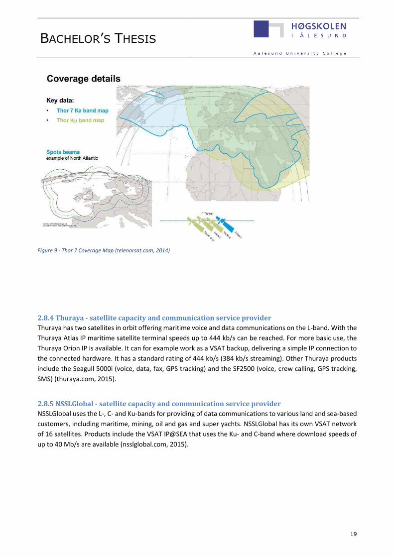
Barents Sea, the Red Sea, the Baltic Sea, the Persian Gulf and the Mediterranean (see figure 9).The satellite
operates from position 1° west and offers a throughput of 6-9 Gb/s with up to 25 spot beams active at the
same time. Projected download speed are in the tens of Mb/s and uplink speeds from 2-6 Mb/s depending
on the user antenna size (telenorsat.com, 2014).
Telenor’s Thor 7 satellite will be located at 1° west and provides excellent coverage in the Norwegian Sea, all
the way up to the sea area south of Svalbard. The Thor 7 satellite patches the coverage area gap left by the
Inmarsat 5 satellites and provides a solution to most of the connectivity problems presented in this Bachelor’s
thesis. The Thor 7 satellite has been designed with a special emphasis to serve the purpose of maritime and
offshore users and provide them with fast mobile broadband. The satellite was launched in April 2015. When
it comes operational, connectivity problems for the vessels operating in the Norwegian Sea and the vessels
operating near the coast of Norwegian Barents will be solved as shown in Figure 9.
BACHELOR’S THESIS
19
2.8.4 Thuraya - satellite capacity and communication service provider
Thuraya has two satellites in orbit offering maritime voice and data communications on the L-band. With the
Thuraya Atlas IP maritime satellite terminal speeds up to 444 kb/s can be reached. For more basic use, the
Thuraya Orion IP is available. It can for example work as a VSAT backup, delivering a simple IP connection to
the connected hardware. It has a standard rating of 444 kb/s (384 kb/s streaming). Other Thuraya products
include the Seagull 5000i (voice, data, fax, GPS tracking) and the SF2500 (voice, crew calling, GPS tracking,
SMS) (thuraya.com, 2015).
2.8.5 NSSLGlobal - satellite capacity and communication service provider
NSSLGlobal uses the L-, C- and Ku-bands for providing of data communications to various land and sea-based
customers, including maritime, mining, oil and gas and super yachts. NSSLGlobal has its own VSAT network
of 16 satellites. Products include the VSAT IP@SEA that uses the Ku- and C-band where download speeds of
up to 40 Mb/s are available (nsslglobal.com, 2015).
Figure 9 - Thor 7 Coverage Map (telenorsat.com, 2014)

BACHELOR’S THESIS
20
2.8.6 Airbus Defence & Space - satellite capacity and communication service provider
Airbus Defence & Space provides maritime satellite communication solutions for some of the biggest shipping
companies in the world, but is currently evaluating the sale of its maritime communication division. Airbus
Defence & Space also co-operates with other satellite solutions providers, including Inmarsat. They provide
solutions for maritime, offshore, drilling, cruise and ferry operators. With cruise and ferry operators, a full
set of communication tool is provided from voice communications to Internet access, Wi-Fi, Internet Café
and GSM. The products Pharostar and Pharostar Plus use Iridium OpenPort/Pilot or Inmarsat FleetBroadband
as backup system. They provide connection speeds of up to 4-6 Mb/s on the Ku-band, and global L-band
connectivity of up to 432 kb/s. Low cost connectivity up to 64 kb/s for low data requirements is also available
(satcom-airbusds.com, 2015).
2.8.7 Marlink - satellite communication service provider
Marlink is now a part of Astrium, the aerospace subsidiary of the European Aeronautic Defence and Space
Company, EADS. Marlink offers voice and data communication solutions, with speeds from 64 kb/s up to 40
Mb/s available through SeaLink. They can use Iridium and Inmarsat satellites, but also their own C-band and
Ku-band VSAT solutions, with Ka-band coming in the future. Iridium OpenPort/Pilot is used as a backup
system. This enables vessels to maintain satellite connectivity anywhere, but with a much lower bandwidth.
Marlink is Inmarsat’s biggest customer in Mobile Satellite Services (MSS), where you pay for the data usage
instead of a monthly fee, and Intelsat’s biggest customer on Ku-band maritime VSAT. Their VSAT services are
called SeaLink, WaveCall and Wavecall Plus. Sealink is used on seismic-, survey-, subsea-, construction-,
supply-, cable-laying- and multi-purpose vessels as well as drilling and production oil rigs (marlink.com, 2015).
2.8.8 MTN – satellite communication service provider
MTN delivers VSAT satellite capacity and solutions via C-, Ku-, Ka- and X-bands (military use). MTN have plans
to include High Throughput Multi-Spot beam capabilities to their portfolio in 2015 (mtnsat.com, 2015). MTN
is one of the biggest sellers of telecom equipment to the cruise and yachting industry, however they do not
actually own any satellites. Instead they buy satellite capacity from satellite capacity providers to satisfy
customer needs.
2.8.9 Speedcast – satellite communication service provider
Speedcast is a network and satellite communication service provider that operates in over 60 countries and
has a global maritime network. Speedcast co-operates with e.g. O3b Networks, Intelsat and Inmarsat for High
Throughput Satellites (HTS) (speedcast.com, 2015).
Seacast
Seacast is a maritime broadband solution with a worldwide coverage. It uses the Ku-band and has been
operational since 2008. Speedcast uses the L-band services from Iridium Pilot or Inmarsat FleetBroadband as
back-up. Seacast serves also the needs of offshore drilling operations and production platforms, drill ships,
seismic-, survey- and service vessels (speedcast.com, 2015).

BACHELOR’S THESIS
21
2.8.10 SES – satellite capacity provider
SES owns and operates 54 geostationary satellites and several teleports (ses.com, 2015). There is a great
focus on maritime clients and the satellites cover all of the world’s oceans. Services provided are voice, data
and video communications to vessels. They provide capacity to Astrium and NSSLGlobal, and high-speed
broadband via NSSL Global’s Cruise-IP service provides Internet access at 8 Mb/s (ses.com, 2015).
2.8.11 Eutelsat - satellite capacity provider
Eutelsat has 37 satellites that provide capacity to TV-operators and video, data and Internet service providers.
The markets include shipping, oil and gas, cruise ships, ferries and yachts. They have partnerships with other
satellite operators to provide vessels with communication solutions. Eutelsat broadband uses Ku-band VSAT
and antennas of one meter in diameter (eutelsat.com, 2015).
In the future, an always-on service delivering speeds of up to 20 Mb/s downstream and 6 Mbps upstream
will be possible using the Ka-band, and professional users can use the KA-SAT terminal for up to 50Mbps
download and 20 Mb/s upload speeds. Seven satellite launches are scheduled up to 2017 (eutelsat.com,
2015).
2.8.12 Intelsat - satellite capacity provider
Intelsat provides services for aeronautical, maritime and offshore communications. They support various
different antenna sizes and modem solutions from different manufacturers. Intelsat has a global C-band
coverage and Ku-band coverage over major shipping routes. Intelsat provides the satellite capacity and land-
based infrastructure for the marine communication service providers, which then provide the services
required by the end user. Intelsat currently has a fleet of approximately 50 satellites and in the future, the
number will increase when the new satellites for the EpicNG service are operational (intelsat.com, 2015).
Figure 10 - Intelsat EpicNG Coverage (intelsat.com, 2015)

BACHELOR’S THESIS
22
Future Intelsat satellites and the EpicNG platform
The Intelsat 29e and the Intelsat 33e satellites will be launched in 2016. The EpicNG platform will be available
when these satellites are operational. The EpicNG platform uses the C-, Ku-, and Ka-bands, and combines the
use of old and new satellites giving great flexibility for customers. The EpicNG will use both wide coverage
beams and spot beams with good Arctic coverage. Intelsat EpicNG will be backwards compatible, so it will
work with the user’s existing hardware and network infrastructure (intelsat.com, 2015).
2.8.13 Gazprom - satellite capacity provider
Gazprom Space Systems provide Internet access using C-band capacity from the Yamal-202 satellite, C-band
and Ku-band capacity from the Yamal-201 satellite. The coverage zones reach the Arctic areas situated above
Russia’s northern coast, covering the NSR with an elevation of 5 to 10 degrees. New satellites, the Yamal-
300K (2012), Yamal-401 (December 2014) and Yamal-402 (2012) have been launched recently, increasing
Gazprom’s satellite capacity from 66 to 272 transponders (gazprom-spacesystems.ru, 2015). The Russian
field, Prirazlomnoye, situated only 60km of the coast at 69 degrees north, is equipped with ku-band Vsat
technology from the Gazprom space program (Pettersen, 2011).

BACHELOR’S THESIS
23
Chapter 3 - Terrestrial communication solutions
Besides satellite communication, there are two other main technologies available for offshore
communication; terrestrial wireless transmission using microwaves and sub-sea fibre optic cables. In recent
years, the offshore industry has had a rapid increase in its demand for capacity and speed, something the
satellite solution providers only now are catching up to. The currently available data speeds and capacities
provided through satellite are insufficient for top-end users, thus satellite Internet today is used merely as a
secondary backup system for gaining Internet access. The use of satellite communication only, can cause
bandwidth restrictions and some connectivity issues in areas with bad coverage.
A common principle is to make sure the connection is redundant, meaning that any single point of failure is
still manageable and the data can be sent through an alternate pathway to the receiver; either using one
type of technology with several different pathways or several different technologies working together.
3.1 Terrestrial wireless transmission Terrestrial wireless transmission is used globally where offshore communications is needed. The multiple
service providers working in the offshore communication business use several different technologies. The
market is constantly evolving and pushing itself towards new capacities and maximum operation ranges.
3.1.1 Point to Point Microwave Radio
Point-to-Point Microwave Radio is the second most common solution for offshore communication after
satellite connectivity. Point-to-Point microwave systems are highly reliable and well proven offshore, these
type of solutions have been around for several years.
Each platform is connected to the next platform using antennas. The signal “jumps” from platform to
platform, using the closest platform as the next link. The original signal travels further to its final destination
or reaches land to a receiving point onshore, where there is a connection to Internet landlines. The data
performance is close to what the fibre optics can provide in terms of both data throughput capacities (several
gigabytes) and latency, so it performs better than the VSAT systems currently available. The current range
limitations for Point-to-Point Microwave Systems are about 30-50km travelling from rig to rig. The signal path
requires that the antennas are within line-of-sight of each other. This limiting issue can be solved by placing
signal repeaters on islands or similar stationary objects located between connection points. The range can
also be extended by using higher antennas. There are two ways of connecting multiple communication points
while still maintaining redundancy; a star topology or ring topology (see figure 11). The simplest solution is
to use a star topology where there is a central hub to whom all of the points communicate back to. When
using a ring topology, all of the points are arranged in a circular fashion, which reduces the range between
points, making it more desirable for offshore networks (rdlcom.com, 2013). Another challenge with a
conventional Point-to-Point network is the connection between a platform and the moving vessels around
it, such as supply vessels and shuttle tankers. This is still the main issue when using this type of
communication solution offshore. However some communication providers such as Bats, Ceragon and
Tampnet have been able to solve this problem by using antenna stabilization systems. Still, voice
communications and data transmission between moving objects is a major issue (enterprise.huawei.com,
2015).

BACHELOR’S THESIS
24
Figure 11 - Star Topology left, Ring Topology right. (Yeager, 2013)
3.1.2 Ceragon PointLink
Ceragon provides high-capacity wireless network solutions for a wide variety of network operators. Their
marine-grade microwave radio link system called PointLink is designed to overcome the traditional problems
with microwave Point-to-Point systems, by using advanced Evolution-series long haul radio technology.
PointLink is designed to provide connectivity between moving objects. The technology consists of a GPS, a
gyro stabilized 360-degree antenna, and motion sensors. It is able to keep constant tracking and maintain
perfect antenna alignment with an offshore vessel or a land based facility. Temporary loss of sight and the
effects of multipath fading are solved by having two separate antennas transmitting identical signals at two
different frequencies; a technique Ceragon calls Quad Diversity. The system is able to provide the users with
almost 100% mission grade availability. To maintain quality in various different weather conditions, Ceragon
supplies the links with high fade margins and adaptive coding and modulation in order to keep the link
running even in rough weather conditions. Ethernet/IP-traffic over a signal channel transmits at over 250
Mb/s and by using multiple carriers; the speed can be boosted up to 1Gb/s. PointLink holds the world record
for longest over-water offshore link, connecting mainland of Norway with the oil rig Yme in the North Sea.
The link has a span of 123 kilometres and a capacity of 128 Mb/s (ceragon.com, 2015).
3.1.3 Wireless multipoint broadband
Multipoint networking is a new trend in the offshore sector similar to the mobile phone network solution we
use every day onshore. It is based on the topology of the mobile phone network, being a cellular network.
The multipoint technology uses a base station in the centre with multiple points interconnected to it within
a geographical area (see figure 12). In order to have a coverage area that meets the demands of offshore
operations, several base stations must be operational located within the range of 20-30km radius from each
other. This kind of network solution has now become possible in areas where platforms are located relatively
close to each other. The performance is not as good as a Point-to-Point system or a fibre-optic cable, but it
is still much better compared to traditional satellite Internet. In some cases the base station for the multipoint
wireless are connected with a fibre optic network, or with a wireless connection known as point-to-
multipoint (PMP). Some of the high-end multipoint solutions available in the market provide throughputs of
over 100 Mb/s and latencies of fewer than 3ms.

BACHELOR’S THESIS
25
The multipoint system can also offer excellent connectivity with mobile objects such as ships and moving drill
rigs. The systems topology offers unmatched flexibility, but the initial setup of base stations is more time
consuming than both satellite and Point-to-Point solutions. Multipoint networks have still become quite
popular due to good performance, mobility, reliable coverage and the possibility of very quick deployment
of new communication points within the service area. Popular multipoint technologies are Wi-Fi mesh,
WiMAX and LTE (Long Term Evolution). Wi-Fi mesh is an excellent technology for covering the on board Wi-
Fi connectivity needs for an individual platform, but the short range makes it useless elsewhere. The WiMAX
made a giant step forward in wireless technology, but LTE managed to overcome its gaps in order to make it
useful offshore. LTE is the technology of choice when developing new 4G mobile systems, like the first 4G
network deployed in the North Sea by Tampnet.
Tampnet is a telecommunication operator in Norway who leases high-bandwidth communications services
to 68% of the offshore development in the North Sea. The company owns most of the fibre-optical cables
running on the seabed and has 50 microwave radio links in the area. Until recently, access to the Tampnet
network was reserved for stationary objects, and the vessels and rigs operating near existing Tampnet
infrastructure were not able to connect to the network. The company has since co-operated with Huawei
and created the world’s first offshore LTE communication application. This network is able to serve an FPSO
with symmetrical bandwidths in excess of 12 Mb/s more than 20km away from the base station
(tampnet.com, 2014). From already existing infrastructure, the system enables users to have voice and data
communication between platforms and vessels within 37 km. As the new LTE technology expands further,
offshore vessels and even fishing vessels operating in the coverage area could start using it, creating a real
to satellite Internet.
Figure 12 - Multipoint network; cellular topology. (Yeager, 2013)

BACHELOR’S THESIS
26
3.2 Troposcatter The Troposcatter radio system was developed in the early 1950`s and used in the Arctic to form a Distant
Early Warning Line (DEW Line) that extended for thousands of kilometres above the Arctic circle connecting
a series of radar sites used for military defence. This system has been used in the offshore sector
commercially since the 1960`s (comtechsystems.com, 2013). The Troposcatter system is a communication
method that uses microwave radio frequency communication that is able to work even when the antennas
are beyond the line of sight of each other. Using the tropospheric scatter phenomenon, the signals can travel
up to 300 km, depending on climate and terrain factors. The radio signals are transmitted in a tight beam
towards the receiver station on the highest point of the horizon. Frequencies are then randomly scattered as
they pass through the upper layer of the troposphere. The receiver station is able to pick up these signals
when some of the energy gets scattered back towards the earth (see figure 13).
The best frequency used for transmitting is 2 GHz as this wavelength interacts well with the moist, turbulent
areas in the troposphere, improving the signal to noise ratio. Troposcatter has virtually no latency and can
deliver connections speeds up to 22 Mb/s. Troposcatter links are controlled by the platform operator, unlike
the VSAT systems which are controlled by satellite operators. Troposcatter generally has higher availability
than other radio systems (comtechsystems.com, 2013). The Troposcatter system is also able to utilize
stabilized antennas in order to connect to offshore floating platforms operating in various sea states,
maintaining high quality of service from a land-based communications center (marinelink.com, 2013).
Today the system can be combined with high-speed modems with advanced signal processing. This enables
digital voice, data and video to be streamed across highly reliable links. The system can be used in commercial
applications as part of a communications network. Comtech Systems are the world leader in digital
Troposcatter systems of today. Troposcatter offshore links provided by Comtech that are used offshore today
range from analogue channels used in Aberdeen to systems with a 20 Mb/s capacity used in Malaysia
(comtechsystems.com, 2012).
Figure 13 – Troposcatter technology (comtechsystems.com, 2013)

BACHELOR’S THESIS
27
3.3 Fibre optics Fibre optic communication is regarded as the new revolution in offshore communications. Fibre optic cables
offer high capacity broadband with virtually no delay. This allows for instant distribution of critical data, which
again increases efficiency and enables major cost savings. The improvements in efficiency, reliability and
security of the information flow between platforms, shore-based facilities and different operations around
oilrigs have provided great financial benefits. The oil and gas companies that have chosen to use fibre optic
communication solutions on their fields around the world have reported a 25% reduction in operating costs
and an 8 % increase in production rates (Specialists, 2015). These high figures are presented as a part of using
the Integrated Operations solution (see chapter 5) on board the platforms and cannot be directly connected
to the the fibre optic system.
By using fibre-optic cables to connect offshore platforms to land-based infrastructure, a throughput of
hundreds of gigabits is available for use. The speeds achieved with fibre optic cables are not comparable with
traditional VSAT links or any other technologies we have available today. Fibre-optic based communication
offers the capacity requirements needed by the oil & gas industry and even exceeds them by a great margin.
In addition a fibre connection eliminates most of the latency problems; the latency when using fibre optics is
as low as 20-50 milliseconds.
The greatest challenge today regarding the use of fibre optic cable is the cost, especially for the platforms
that are located far away from shore. Deploying a sub-sea optical fibre cable is an extremely costly affair,
which requires careful planning and the use of several vessels. The economics of sub-sea cables are based on
that a large number of users share the total cost, so that the cost per user becomes lower. When a sub-sea
fibre cable is used to carry several terabytes of traffic from different users, the cost per transmitted bit is low,
but for a single user that would just use a fraction of the available capacity the cost per transmitted bit is
extremely high. One of the leading service providers, Harris CapRock Communications, now claim that they
can offer fully configured solutions with long term leases that spread costs over several years and among
multiple customers, and thus can offer fees comparable to traditional satellite systems (Joe Friedman, David
Pfosi, 2014).
A fibre optic cable is mostly used were it can be connected to a cluster of platforms such as Tampnets offshore
network in the North Sea. Tampnets network serves approximately 200 platforms, FPSOs and floating rigs
and is the largest offshore high capacity communication network in the world (tampnet.com, 2015). Subsea
fibre can also be desirable and efficient even when used just for one platform, because once the fibre Internet
backbone is installed, the connectivity can be “hopped” to assets surrounding the platform by using solutions
mentioned earlier. In this case, the fibre optic network serves almost as the Wi-Fi system we use in our
homes, only on a much bigger scale.
Another discussed aspect of sub-sea fibre optic cables is their vulnerability to physical damage. Natural
disasters such as mudslides, typhoons and earthquakes have caused serious damages to cable networks on
the sea bed in the past. In addition, generally bad weather and dragging ship anchors post a threat to subsea
fibre. Reparations can be complicated, as the cable has to be lifted from the seabed and repaired on-board
a specialised vessel.

BACHELOR’S THESIS
28
Repairing physical damages to a deep-water sub-sea fibre cables is costly and time consuming. The company
Arctic Fibre is now deploying a 15.000km subsea fibre cable connecting Tokyo and London trough artic
waters. The installation is possible during the warmer months, but their greatest issue is the restrictions
regarding repair 12 months a year (Coffey, 2014).
On the other hand, fibre optics have proven to function even in the harshest of environments and remote
locations found on Earth. The oil company BP created in 2008 the longest fibre network dedicated to oil and
gas in the world, in the hurricane prone area of the Gulf of Mexico (Joe Friedman, David Pfosi , 2014). In the
arctic, the Goliat platform are going to use subsea fibre optics (See chapter 5.2). The Russian Shtokman
development have announced that they will use a 550km long fibre optic cable connected to the platform.
The Shtokman gas field is situated at 74 degrees north. It holds more gas resources than the entire North
Sea, but it is very unclear if the project is under way or has stopped (Development, 2013-2015).
Besides its capacity, reliability and latency figures, professionals argue that the greatest value a high-speed
fibre optic connection can provide is the cost savings. For example, in the event of an emergency on an
unmanned platform, the advantages of being able to remotely command and control complex systems like
sensors and bilge pumps using the weather-immune fibre optic communication systems cannot be
overestimated. The reliability and speed of the connection can be the difference between minor damage and
the total loss of the installation. Another aspect of fibre is the possibility for customers to transfer large
amounts of data at high speed without having to worry about extra costs (Joe Friedman, David Pfosi , 2014)

BACHELOR’S THESIS
29
Chapter 4 – Possible Future Marine Communication Solutions
With the solutions presented previously one can easily see that when a ship is working close to a coast or
near a rig, the communication problems can be solved easily. The real challenge now is how industries such
as fishing and tourism can stay connected with the rest of the world while keep pushing north in to territories
without the possibility for terrestrial solutions. According to the Norwegian Space Centre, satellites are the
only solution (romsenter.no, 2014).
4.1 Highly Elliptical Orbit Satellites As mentioned in chapter 2, HEO satellites are very well suited for bringing satellite communication to the
area north of 75°, and according to the Norwegian Space Centre, two HEO satellites will be enough to provide
complete coverage. They also state that for ships using GEO satellites the transition to HEO satellites would
be seamless (romsenter.no, 2014).
The Molniya orbit, seen in figure 13, is just one of many possible HEO orbits. Other HEO orbits include the
Tundra and Three Apogee (TAP) orbits. All of which have an inclination of 63,4° same as the Molniya. What
separates the orbits is the distance from Earth, and how much time it takes to complete one orbit. The
pictures below illustrates the footprint of the three different types when two satellites are used (Trishchenko,
2012).
Figure 15 - Tundra Figure 16 - TAP Figure 14 - Molniya

BACHELOR’S THESIS
30
4.1.2 The Polar Communications and Weather Mission
PCW is a project started by the Canadian Space Agency with a goal to launch two HEO satellites for
communication, weather monitoring and space weather monitoring. Should the project move forward and
be approved by the Government of Canada, it is estimated that the construction of land and space segments
would start in November 2016 (Boucher, 2013). The project was initially estimated to cost 600 million CAD,
but industrial sources says that the cost could very well climb to 800 million dollars or even higher (Pugliese,
2014). The Request for Information (RFI) by the Government of Canada (GoC) concerning PCW was closed on
the 10th of October 2014. The GoC said in a brief summary that it thanked all the participants and that all
the information collected would be used when moving forward with the project. Since then, no news on the
project have been posted on their website (GoC, 2014).
The Molniya orbit that is frequently suggested as a solution for communication in the Arctic regions gives
good coverage, however the nature of the orbit exposes the satellite for very harsh proton radiation in space.
Research done by Canada’s Department of Natural Resources and Environment Canada shows that the most
optimal orbit would be a 16 hour TAP orbit (Alexander P. Trishchenko, Louis Garand, 2014). However, it is
unclear if this is the actual orbit they are planning to use or if they are going for the standard Molniya orbit.
4.1.3 The Arktika Project
The Arktika Project is an ambitious project by the Russians with a plan to launch 10 satellites in two different
kinds of orbit; HEO and sun-synchronous. The project was first discussed on government level in 2007. In
2010 Roskosmos said that the project would cost 2.3 billion USD. Three of the satellites, using a Tundra orbit,
were meant for commercial mobile communication in the Polyarnaya Zvezda network (Anatoly Zak, Nicolas
Pillet, 2013). The development of these satellites was delegated to Gazprom Space Systems, but no
information regarding the data capacity or future plans have yet been released for the public. In 2012
Roskosmos assigned the company NPO Lavochkin to construct the satellites, planned launch as of 2013 was
to be in 2015 (medium.com, 2013).
4.1.4 Challenges related to Highly Elliptical Orbits
Since the satellites in HEO are moving relatively fast both towards and away from the Earth, the systems
using them have to be able to cope with a quite large Doppler shift in the signal from the satellite. In addition
the satellites are exposed to proton radiation. This happens when the satellites pass through the Van Allen
belts, which are two belts made up of electrons and protons caused by the Earth’s magnetic field. These belts
give satellites in HEO a relatively short lifespan (D., 2010). For example the satellites built for the Arktika
Project have an expected lifetime of just seven years (roscosmos.ru, 2010), compared to a modern GEO
satellite with a planned lifetime of 15 years (space.skyrocket.de, 2014). Another disadvantage is the need for
constant satellite tracking, because the satellite is not always located in the same spot on the sky. A system
with satellites in HEO also requires numerous Land Earth Stations (D., 2010).

BACHELOR’S THESIS
31
4.2 Unmanned Aerial Vehicles Researchers at the Norwegian organization MARINTEK are suggesting a solution where Unmanned Aerial
Vehicles (UAV) or High Altitude Platforms (HAP) would be used as relay stations for GEO satellites (Bekkadal,
2014). UAVs are becoming increasingly common and there are several commercial producers in the market
with HAPs available capable of year long flights and Arctic weather conditions. U.S. Military is already using
this kind of solutions with their GlobalHawk and Predator UAV’s operating in war zones (Boeing, 2014).
4.2.1 Quarkson
Quarkson, a Portuguese company which is currently seeking sponsors, is set on bringing Internet access to
every person on the globe with their SkyLink system and seeks to cooperate with both governments and the
commercial sector. Their HAP called SkyOrbit HA75 can stay at a height of 22 kilometres for up to five years
and relay signals from both ground stations and satellites via UHF, L-, S-, C-, X- and Ku-band. Quarkson has a
special challenge aiming for the Arctic claiming the following;
“The SkyOrbiter’s lightweight though robust airframe make it ideal for all climates, including the extremely
demanding Arctic climate.” (quarkson.com, 2015)
The vision by Quarkson is to provide a complete solution combining HAPs, earth stations and satellites (see
figure 17). A so-called Constellation Manager communicates with one or several SkyOrbiters
simultaneously. Communication between the Constellation Manager and the SkyOrbiters can be done with
line-of-sight communication or via satellite. The Constellation Manager is designed as a modular control
centre and can
supposedly be
set up in any
vehicle or
container.
Quarkson will
have their first
test flight on the
30th of April
2015.
(quarkson.com,
2015).
Figure 17 - SkyLink system with satellite and SkyOrbiter (quarkson.com, 2015)

BACHELOR’S THESIS
32
4.2.2 Google
Google acquired the company Titan Aerospace in the spring of 2014. They produce drones that can fly for up
to three years at a height of 20 kilometres while transmitting Internet to the ground below at speeds of up
to 1 GB/s (Neal, 2014). Google calls the project Project Titan and will begin testing of the new Solara UAV
over New Mexico later this year (Warwick, 2015). Google has another project called Project Loon which uses
hot air balloons to transmit Internet. However it is hard to say if any of these projects are applicable for
marine users in Arctic waters.
4.2.3 Facebook
Facebook is also aiming on bringing the world global Internet through drones and have acquired the company
Ascenta. Drone testing is currently taking place in the UK (Lavars, 2015). But as with Google’s project, Arctic
waters is probably not Facebook’s number one priority.
4.3 Low Earth Orbit Solutions
4.3.1 OneWeb
OneWeb is a company founded by Greg Wyler, the
same man that founded the satellite solutions
provider O3b. The company aims to have 648 LEO
satellites (see figure 18) using the Ku-band by 2018
with a throughput of 6 GB/s per satellite (Selding,
2015). The great advantage of this system is the
enormous decrease in latency. It is expected that the
time delay would go down to only 20 ms (Vance,
2015), compared to O3b which has a delay of 150 Ms
and tested speeds of up to 500 Mb/s
(digitalship.com, 2014). Of course one major
disadvantage of the system is that you need an awful
lot of satellites in order to achieve global coverage.
The antenna, also provided by OneWeb, is about the
size of a car tire and is said to be so easy to install
that anyone could do it. Since there are so many
satellites in the sky, no tracking is needed. In fact the founder Greg Wyler says you would have a hard time
not getting a reception. All you have to do is aim the disc straight up towards the sky and you will receive a
signal (Vance, 2015). The company is currently in a bidding process with five different companies on who
will produce the satellites. The challenge for the bidders is to build relatively cheap satellites (less than
500,000 USD per satellite) and being able to build many of them per month. Because you need spare
satellites standing by on Earth, it is estimated that around 900 satellites will have to be produced (Selding,
2015).
Figure 18 - OneWeb LEO Constellation (Vance, 2015)

BACHELOR’S THESIS
33
4.3.1 SpaceX
SpaceX, a company that designs, manufactures and launches advanced rockets was launched in 2002 with,
as they themselves put it, a goal to revolutionize the space industry (spacex.com, 2015). Previously they have
only launched other companies’ satellites, but are now planning to design and launch their own. In fact,
SpaceX CEO Elon Musk wants to launch roughly 4,000 LEO communication satellites to provide global Internet
access. SpaceX does not seem to have gained the rights to broadcast on any frequency band yet and Musk
says that the system probably won’t be operational for another five years (Dano, 2015).
However, satellite industry consultant Roger Rusch says the following to the LA Times regarding OneWeb
and SpaceX:
"It's highly unlikely that you can make a successful business out of this…It is inconsistent with experience.
These people are up against the laws of physics." (Petersen, 2015)

BACHELOR’S THESIS
34
Chapter 5 – Future Demands and the Digital Oil Field
5.1 The Digital Oil Field The Arctic region is becoming more accessible for ships, partly because of climate change and less ice-
coverage. The ship traffic in the Arctic region today is mostly related to the oil- and gas sector and the fishing
industry, but there has been an increase in amounts of passenger ships sailing in the area during the summer
season as well as vessels doing scientific research. Although there are diverse types of vessels present in the
area, the future demand for increased bandwidth in the Arctic will mainly be driven by the oil and gas sector.
For them the access to higher Internet speeds with more broadband connectivity is critical for the success of
the planned future activity in the Arctic.
Offshore oil and gas operations are moving toward a new model called Integrated Operations (IO) also known
as the Digital Oilfield. This type of new work methodology involves the integration and interconnection of
units, facilities and resources in order to increase efficiency in oil and gas production, increase safety and
security while at the same time decreasing the total costs and need of personnel; this kind of new thinking is
a breakthrough in the oil and gas industry.
The personnel that would normally work on-site offshore are now able to monitor the on-going operations
while physically placed onshore, with access to the data from multiple locations on-shore while working in a
safe environment. For example, the remote field assessment and management brings the oil field straight to
the operator and enables new ways of working as the operator can analyse and process the data anywhere.
The operator could even theoretically control and monitor several offshore units at the same time. Integrated
Operations require bandwidth that is beyond what the satellite VSAT systems can offer today: the Internet
speed requirements for the IO system to work are 32 Mb/s for the drilling rigs and over 100 Mb/s for the
larger production rigs (Paschoa, 2015). Oil and gas fields have extensive monitoring systems that are used for
gathering and transmitting critical information and data from the field to the people located in the control
room. The control room manages the pumping systems, valves and drilling equipment as well as monitoring
all the different parameters on the displays. Monitoring the operations closely for any anomalies enables the
operators to prepare and react to emergencies immediately.
Security-related systems are also becoming increasingly important due to the vulnerability to crime and
terrorism. They consist of intrusion detection systems, access devices, surveillance cameras and monitoring
consoles (subseawireless.com, 2015).
Data requirements for the oil and gas industry can for example consist of the following:
- Always –on video conferencing between offshore and onshore facilities
- Data collection and storage
- Remote-control of electrical and mechanical equipment on board
- Machine to machine applications
- Monitoring, analysis and logging of data
- Internet access

BACHELOR’S THESIS
35
When implementing a communication system to a new offshore field there are some basic things that have
to be taken in to consideration regardless of the chosen communication solution. For example, it is essential
that the existing infrastructure both onshore and offshore is compatible with the new systems for reduced
cost and complexity, and there should be a possibility to connect new units to the existing system later on
when the field development progresses. There should also be knowledge about the planned activity in the
area, so that in the future the same basic data infrastructure can be used, although some customization can
be necessary depending of the platform type used.
Mission-critical considerations:
- Cost; both the initial capital cost and the operating cost.
- Capacity: Usually linked directly to the cost; the higher the capacity, the higher the costs.
- Reliability and availability: The reliability of the communication link is critical, as there is a high level
of risk associated with the loss of communication to the vessel/rig. There are both equipment and
transmission reliability that have to be taken in to consideration.
- Back-up: Essential in operations due to safety reasons and the possibility of great financial losses.
- Physical facilities used on-board: The selection of equipment depends on factors such as availability
of a power outlet, access to back-up power, the space available, positioning of the system (on the
floor, deck, wall) and the hazardous area restrictions.
- Possibility for remote access: Monitoring and controlling the equipment off-site.
- Customer service: specific types of services (maintenance, alterations) can be required from the
system provider during the lifetime of the product. The system requirements may increase and new
updates are needed during the lifetime of the product.
- Offshore networks: having several platforms operating in one area can increase the total coverage
of the communication system, and even prove the link to a shore site. This is an important factor
when making the initial investment decision and when planning the future developments of the field.
- Safety regulations: Equipment and technology have to be approved to meet the high safety standards
offshore, such as performance in highly explosive environments.
5.2 The Goliat Project Goliat is the first oil field that will come in to production in the Norwegian part of the Barents Sea. The field
is located about 85km northwest of the city Hammerfest, Norway. The complexity of this pilot project has
led to that the whole project is running two years late and greatly over budget. The harsh Arctic conditions
and freezing temperatures at the work site have been taken in to consideration when designing the FPSO.
The Goliat field will use the Sevan 1000 cylindrical design for the Goliath FPSO. The FPSO was designed in
Arendal, Norway and built by Hyundai Heavy Industries in Ulsan, South Korea. The Goliat platform is the
largest and most complex sircular FPSO ever created. The Goliat FPSO was carried by the heavy-lift vessel
Dockwise Vanguard from Korea to Norway and arrived in Hammerfest in April 2015. The planned production
start for the field is in the summer of 2015 and the estimated production capacity of the FPSO is 100,000
barrels of oil per day (eninorge.com, 2015).

BACHELOR’S THESIS
36
ENI owns 65% and Statoil 35% of the field. (Production Licenses PL229/229B) (eninorge.com, 2015). The field
was discovered in the year 2000. The estimated total cost of the project is 4.34 billion USD (subseaiq.com,
2015).
The Goliat FPSO is connected to the shore with redundant fibre optic cables. The fibre optic cables were laid
on the seabed integrated with the main power lines running from Hammerfest. In order to serve the platform
with the power needed, the power grid in Hammerfest had to be upgraded. The power lines are the longest
in the world of its kind, and due to this the fibre section of the cable is a low cost. If the FPSO were to be self-
sufficient regarding power, officials from Eni Norway say they would have to make a cost-benefit analysis
when considering the use of fibre as the main connectivity solution. They further announced that satellite
connectivity was not an option, because of problems mentioned earlier in this paper. They will only use the
Iridium satellites as a backup for voice communications (Wennberg, 2015). The FPSO will have a 3x10
Ethernet network and full Wi-Fi coverage everywhere on the platform. As a back-up system, there will be a
radio link for the Internet traffic between shore and FPSO, using two gyro-stabilized antennas and a capacity
of 176 Mb/s. The telecommunication system used will allow technicians to fully support, manage and monitor
the Goliat FPSO from an onshore operation centre in addition to the platform itself: This is why the Goliat
project is an excellent example of the new Integrated Operations work methodology (Figure 18).
Figure 18 - Goliat (Ims, 2011)

BACHELOR’S THESIS
37
An offshore Local Area Network (LAN) will provide the required network infrastructure for the Office Data
Network, VoIP (Voice over IP), entertainment usage and a Wireless Local Area Network (WLAN). The offshore
LAN will also facilitate the radio link connection to shore. The WLAN system will provide mobile access to
high-bandwidth data, voice and video applications throughout to the FPSO.
A Point-to-multipoint communication system (PMP) will ensure a 360-degree LAN coverage to surrounding
vessels around the FPSO, with a range in excess of 10km. This concept will greatly benefit the shuttle tankers
loading oil from the FPSO and the supply vessels working in the field, as they will receive a fast Internet
connection via the FPSO. Specialized shuttle tankers and supply vessels are made to comply with the Goliats
high operation standards, in addition fishing vessels have been customized to work as an oil spill readiness
fleet. The connectivity solutions makes videoconferencing between the FPSO and these vessels possible
(eninorge.com, 2015). This is just one of many new concepts developed for the Goliat project, as few of the
solutions needed can be found as ready off-the-shelf products. Most of the components used are tailor-made
or customised from pre-existing products in order to enable safe and reliable oil production under harsh
weather conditions in the Arctic. The shuttle tankers, standby- and supply vessels will have a VSAT connection
for back up as well, in addition to regular mobile broadband (Wennberg, 2015).
An application has been developed for Goliat`s Integrated Operations, connecting more than 20 operation
processes from all operational units spanning from the reservoir and oil-well all the way to production and
logistics. Goliat’s IO includes automation, advanced work processes, graphical presentations, trend functions,
automatic warning systems and an operational knowledge base (eninorge.com, 2015).
5.3 Snøhvit The Snøhvit gas field is located in the Barents Sea about 145 km North West of the city of Hammerfest. It is
the first major development on the Norwegian continental shelf with all of the equipment used in the
production installed directly on to the seafloor. The Snøhvit development consist of three fields, Snøhvit,
Albatross and Askeladd found in 1984. The first two fields came on stream in 2007 and their output is
transported through a pipeline to shore (statoil.com, 2015). The installation uses optical communications
system without repeaters, using a fibre-optic link as the principal means of communication to satisfy
relatively high data needs. The fibre-optic link is redundant and delivers a capacity of 10 Mb/s (VetcoGray,
2008). Subsea technologies hold the key for future field developments in deeper waters and more complex
reservoirs. There is a worldwide trend towards greater use of subsea developments.
5.4 Future Demands North Energy has been working on developing scenarios for the Barents Sea in recent years. They predict
that the bulk of new discoveries are likely to be developed with subsea installations. However, the climate
and large distances will require floating assets, able of meeting demands for safety and environmental
protection. The predicted scenario (see figure 19) consists of major pipelines on the seabed in order to export
oil and gas from the facilities. This scenario looks much like the Goliat and Snøhvit installations, only on a
larger scale with greater infrastructure.

BACHELOR’S THESIS
38
Figure 19 - Predicted future developments in the Barents Sea (northenergy.no, 2012)
The unique solutions on all levels and new technology developed for the Goliat project makes it a flagship
for the floating production units of the future. There is no doubt that connectivity is a plays a huge role in
this development.
“Broadband data communications is rapidly emerging as the single most reliable technology to support the
digital fields of today and certainly of the future.” - Mike Constable, CEO of Huawei Marine Networks.
(oedigital.com, 2014).
One of the research projects Eni Norge AS has been a part of developing is SECurus (norskdesign.no, 2011).
SECurus is a complex system that combines picture and video monitoring with the FPSOs own navigation
system to detect oil spills and to search for persons over board. It can also be used to assist in difficult
operations. The key feature of this system is the ability to share information from the FPSO to shore, enabling
greater co-ordination between the two. However, this requires reliable, high capacity communications. This
is one of many ground-breaking technologies following in the wake of the Goliat project.
Companies like Statoil, Petrobras and Shell are now actively investing in new 4D seismic systems. Sensors
located on the seabed communicate with the platform. From the platform, the data goes onwards to shore
where it is analysed and processed by reservoir engineers in order to use the oil and gas reservoirs more
efficiently. This is the new big thing for further exploit of resources, which will require a lot of bandwidth.
(oedigital.com, 2014).

BACHELOR’S THESIS
39
The people working on-board vessels and rigs sometimes have to do jobs that requires expertise that is above
their own capabilities, which means they have to get support from experts located onshore. This distance
becomes a connectivity collaboration issue. An additional challenge in Arctic locations is that human beings
are not meant for outside work at -40°C. Much of the work being done is still done manually. More
automation, working from a remote location and taking the humans away from the hazardous activities is
the new step within the industry. (oedigital.com, 2014)
“At some stage I thought my job was developing new technology for Shell. Right now it is more like
developing Shell to use new technology.” - Berry Mulder, Shells team leader “Frontier Automation”
(oedigital.com, 2014)

BACHELOR’S THESIS
40
Chapter 6 – Discussion
If the oil & gas industry is going to keep developing towards Integrated Operations (IO), satellite
communication is not an option today or even in the near future. Especially for the climate in the arctic, the
O&G industry have to develop new methods for the safety of crew and environment. The development is
moving towards more unmanned operations which means greater connectivity. The only option that we can
see is the one similar to the solution for the Goliat field. A fibre optic cable is connected from shore to the
installation, and the platform provides a connection to the vessels operating around it using point-to-point
technology. When we talked to Eni Norge about choosing the right communication solution for the Goliat
platform, it seemed that choosing a fibre cable was not the obvious choice. If it had not been for the decision
to run an AC power cable from shore and adding the fibre cable in it, a more thorough cost efficiency
calculation would have been required. However, one must think if the price of laying a fibre cable can really
be justified for just one installation?
There is very little information available about the Russian oil and gas activity. The decision to lay a 550 km
long fibre optic cable to the Shtokman field could be justifiable because of two major reasons; the magnitude
of the gas field, which makes it potentially very profitable and long lasting, and the position at 74° north. At
this latitude Gazprom’s satellites have a high degree of connection uncertainty and of course much lower
bandwidth than fibre. Their Prirazlomnoye field however holds less resources and has better satellite
coverage at 69° north. The field is close to the coast, but in order to have fibre, infrastructure onshore is
needed. For the Goliat field, a fibre network was already implemented in the region onshore well ahead of
time.
Since most of the easily accessible oil already has been found, many would argue that subsea installations
are the future. If this is the case, cable connectivity is the only solution for subsea installations available
today, because satellite Internet or Wi-Fi can’t travel under water. In the Arctic area, any kind of unmanned
antenna solution that reaches above the surface of the ocean would be facing big problems such as icing or
the risk of being crushed by floating ice. A new subsea installation located far from shore could be relatively
easily connected to an already established Internet backbone structure with the use of fibre optic cables. The
infrastructure and assets used at the Goliat field could possibly serve new installations located in the same
area with both electricity and connectivity, as well as providing oil spill readiness to some extent.
The oil and gas sector regards fibre optics as the critical component for the use of Integrated Operations, but
this assumption might not be entirely correct. As of today both point-to-point and the Troposcatter solution
is able to deliver the capacity of 100 Mb/s required to apply Integrated Operations. The point-to-point
solution is the least costly option, but has the restriction that the stations have to be within line of sight of
each other. Depending on the elevation of the transmitting and receiving antennas, the range is 30 – 120 km.
At that distance, the primary option for platforms in the past for Internet access has been via fibre optic
cables as the fibre’s speed, latency and data capacity are unmatchable. Troposcatter however provides a high
value alternative compared to other communication systems for floating platforms. Its range of up to 250
km makes it ideal for installations located far away from shore. At great distances, a solution using fibre
becomes very expensive, with high cost of laying the cable itself and maintenance costs if the cable has to be
lifted to the surface for repairs. The communication solution that is chosen for the project depends mainly
on how much the oil & gas companies are willing to pay for connectivity.

BACHELOR’S THESIS
41
Troposcatter has a relatively high initial investment cost. It requires large antennas and high output power.
Despite this, it is regarded as a cheap method of transmitting data compared to fibre because of the distance
it can travel. It has a high grade of reliability and it matches the latency figures of fibre optics. Another aspect
of Troposcatter is its proven ability to withstand the harsh climate of the Arctic. For maintenance and repairs,
it has the advantage of being above water. Although it has less capacity compared to fibre, it may still offer
one of the better options for communication in the Arctic, considering the lack of alternatives.
There is no current microwave technology able to serve ships in transit far away from shore. However, one
could argue that there might be a possibility of using the Troposcatter technology for transmitting data from
ship to shore. This would meet the capacity needs of for example seismic vessels, but would require
development of more advanced gyro stabilized antennas. Satellites will probably fulfil the data capacity
needs in the near future.
Offshore supply vessels have a special way of working; they might stay long periods at port, do a transit trip
to a oil or gas field and then stay there in standby mode for up to several days or even weeks. The best
solution for this kind of vessel would be to use a 4G or Wi-Fi connection when staying in port to avoid the
costs of satellite Internet. However, the price of satellite Internet has gone down significantly in the recent
years, and customers can now choose a system where data usage is billed per month instead of per
megabyte, depending on the specific vessel’s needs. During transit to the oil or gas field, the best solution
would be VSAT. This enables fast Internet access for the bridge operations as well as the crew. When
developing a new oil & gas field, and when in transit, offshore vessels have to use satellites.
Once the connectivity backbone is installed on the platform, the distribution of the connectivity can be done
by using either point-to-point or multipoint solutions. This gives the vessel greater data capacity and opens
up to more possibilities than if using satellite Internet, for example for video conferences and Integrated
Operations.
Point-to-point solutions between the rig and the vessel require gyro stabilized antennas in order to receive
the signal, whereas multipoint networks operate much like a cellular mobile network. In a multipoint network
it is easy for vessels to connect by using a simple antenna. Multipoint technology LTE could expand rapidly in
the future, but this requires the use of many base stations, such as using offshore installations as
communication links. The lack of existing installations in the Arctic means that a point-to-point technology
delivering Internet access from platforms to vessels around it is the most desirable solution, even when
compared to future satellite solutions. The point-to-point system is capable of delivering a high capacity
connection around the platform, with satisfying levels of reliability and availability. The initial investment is
not too costly and when installed, the connectivity is controlled by the operator and not by the solution
provider, like when using a satellite based solution. The satellite services in the Arctic coming in the near
future could turn out expensive for the users as there is only a small customer base sharing the costs in the
beginning. The new satellite services will only be established if there is an existing or projected large demand
from the customers.

BACHELOR’S THESIS
42
Either way, the oil & gas companies cannot afford the loss of connection. This means that a redundant (fail-
safe/with back-up)) system has to be installed. Using different types of technologies for redundancy makes
the total solution more reliable. As the floating oil & gas installations move further away from shore and
further north, the satellite systems available in the near future will probably be the ones used for backup.
Inmarsat clearly has no plans on entering the market in the Norwegian Arctic with concern to the positioning
of the Inmarsat 5 satellites in the orbit. In addition, the bandwidth offered is not good enough either for
modern cruise ships or Integrated Operations. Inmarsat’s I5-IOR and I5-POR satellites are however well
positioned for serving the Kara Sea, Chukchi Sea and parts of the Northern Sea Route. The question is how
well the Ka-band will function with a low elevation angle.
The same goes for Gazprom’s Ku-band: It covers much of the Northern Sea Route, but the elevation angle
when sailing the NSR will range between 1° and 10°. This could cause problems when there are high waves
or when passing close to other ships and other obstructions. In addition, ships with a deeper draught have
to sail further north because of depth limitations in the shipping lane and then must have another
connectivity option. Another aspect of the future NSR traffic is that in addition to paying for the satellite
services, the shipping companies also have to invest in ships capable of handling the ice conditions. Using the
Northern Sea Route commercially is relatively new and improvements on different levels still have to be
developed. This could mean that it would take several years before we see could see such increase in traffic
that the connectivity provider companies are willing to increase bandwidth and coverage in the area.
The Thor 7 satellite is specifically designed for maritime and offshore users and is available from the 4th
Quarter of 2015. It will solve most of the problems considering mobile maritime Internet coverage south of
Bear Island (Bjørnøya), with download speeds in the tens of Mb/s promised. A ship could theoretically lock
in to the satellite already before reaching the Suez Canal, use it when sailing in the Mediterranean Sea and
the English Channel, and track the Thor 7 all the way to Bear Island at 74° North in the Norwegian Barents
Sea. For the Norwegian Barents Sea the Thor 7 satellite from Telenor provides good coverage and great data
speed, however they are not alone. Many other companies such as Airbus, NSSLGlobal and Marlink have
similar coverage and speeds.
Figure 20 - Inmarsat 5 Arctic coverage (groundcontrol.com, 2015)

BACHELOR’S THESIS
43
The Thor 7 and Inmarsat 5 satellites coverage in the Arctic are somewhat guaranteed for latitudes below the
white lines (see map below), but signal strength may vary. Because of the low elevation angle, vessels could
experience loss of signal on the north side of obstructions such as oil platforms. For cruise ships and fishing
vessels travelling to the west coast of Greenland and the fjords of Svalbard a different solution is needed.
It then comes down to four options for communication solutions in the area north of Bear Island and the
Svalbard archipelago; HEO satellites, a terrestrial system, UAVs or LEO satellites. Here we can quickly cross
off a terrestrial system such as multipoint networks, because it is not realistic to put a mast every 30 km on
the north coast of Svalbard. Adding the fact that the fishing grounds reach as far as 100 km off the coast, the
vessels would still be out of range. We are then left with HEO- and LEO satellites and UAVs.
Figure 21 - Inmarsat 5 IOR and Thor 7 coverage on top of 2012 AIS data. Yellow lines are fishing vessels. Turquoise lines are passenger ships. Purple arrows are exploration wells, yellow are production wells. (arkgis.org, 2015) (inmarsat.com, 2015) (telenorsat.com, 2014)

BACHELOR’S THESIS
44
Companies such as SpaceX and OneWeb do not mention helping the Arctic oil & gas- or the cruise industry
with connectivity. They seem more like philanthropists with a goal to somehow save the world with the help
of providing Internet connectivity for everybody. The same goes for Facebook and Google. However, if
OneWeb becomes reality and delivers what it is planned, we do not see why OneWeb could not be applied
to the shipping industry, if compatible user terminals were to be created. Remembering that a company’s
goal normally is to provide its owners with profit, thus no communications company would even consider
entering the Arctic marketplace if there would not be a chance to profit from it.
So is it possible to get any clarity in the Canadian and Russian HEO plans?
Gazprom’s geostationary satellites cover the North East passage, future installations in the Kara Sea and the
Shtokman field with Ku- and C-band beams. So in a way they are in the same kind of position as Norway is
with the Thor 7 satellite. Gazprom Space System’s or Roscosmo’s company websites give no information
about a future HEO constellation or The Arktika Project. In a way it makes sense: Why spend hundred millions
of USD on HEO satellites when they are pretty much covered?
The uncertainty in these future satellite projects makes it difficult to determine what is going to happen. The
same goes for the Canadian PCW project as the Government of Canada have not released any information
regarding further development.
In the future with the new satellite Thor7 and the Intelsat EpicNG constellation being launched, there will
indeed be faster Internet access available in the Arctic. However the speeds available are still not sufficient
to satisfy the needs of cruise ships with several hundred cruise passengers accessing Internet simultaneously.
The service level in the Arctic will not even be close to the one available in the Caribbean, where a bandwidth
of 500 Mb/s per ship is available today. And with Thor 7 and EpicNG being geostationary systems, there is
still the geographical limitation for the coverage area at 74° north. Fishing vessels on the other hand could
benefit from these systems, as they do not require a lot of bandwidth. As the fisheries represents the highest
concentration of traffic moving northwards, they still need better coverage in the northernmost areas.
It remains to see if Iridium can deliver its NEXT system by 2017 as planned, which would give good Arctic
coverage. Although it’s not a broadband solution, it still would have an usable download speed of up to 1,5
Mb/s.
The UAV industry is growing fast and we are able to see good potential, as relaying communication via UAVs
is relatively cheap and efficient. However there is still a lot of testing and development remaining until
reliable systems come available. The commercial development is well under way, for example Quarkson will
start their first tests at the end of April 2015. As the technology is very futuristic we find it very likeable. We
can envision a single UAV relaying signals from a satellite to a cruise ship or a SAR-area in the Arctic. When
the the UAV is flying very high, it can create a link between a High Throughput Satellite and the vessel well
above the latitude 74° north. U.S. Military is already using this kind of UAV solutions operating in war zones.
So the solution already exists, and it is definitely possible to apply to civilian markets. The question is if the
private sector have a big enough customer base to generate enough revenue and profit to cover the costs.
In addition the UAVs should perform well also in an Arctic climate, something Quarkson claims that their
UAVs are able to do.

BACHELOR’S THESIS
45
6.2 Conclusion
6.2.1 SAR
If a ship were to have an emergency in Arctic waters north of 74° latitude, the whole SAR operation gets very
complicated. Right now the only options for ship-to-shore communication in this area are voice
communication over HF-radio and the use of Iridium satellites. In addition there is the EPIRB beacon, which
is used for transmitting the ships position. For search and rescue vessels in this area, increased capacity in
satellite-based communication would be the best solution. Search and rescue vessels could receive the latest
AIS-data, vessel positions, weather information, passenger lists and everything else they need via satellite.
Voice communication via satellite could also function as a backup system for radio communication, if there
were to be a problem with the normal VHF-, MF- or HF-radio. It is still very hard to say if the future LEO
constellations such as Iridium NEXT meet the requirements for a for large scale SAR operations, or if launching
a new HEO satellite constellation is necessary.
6.2.2 The Northern Sea Route
For cargo ships that follow a route along the Siberian and Norwegian coast, a satellite connection is the
optimal solution. Because the area covered by Gazproms satellites is very large, they can in fact stay
connected with the same satellite for long periods of time along the route. There is a high degree of
uncertainty with future traffic passing through the North East passage. The problems are for now only partly
related to connectivity issues. The biggest issues faced are the harsh climate, bad mapping of the sea areas,
the lack of existing infrastructure on shore, and high prices for icebreaker escort. For the larger ships with a
large draft sailing in the northern sea lanes, the coverage area for satellites has to reach further north in
order for them to stay connected all the time. However this is impossible for geostationary satellites.
6.2.3 Tourism
Cruise ships are going further north as their clients seek exotic destinations and new experiences. During the
main Arctic cruising season from April to September vessels travel even as high as Svalbard and Greenland.
In these areas there is no fast broadband which the passengers crave. But more importantly the only way to
communicate with a RCC in the case of an emergency is through Iridium or High Frequency radio. Two
systems with a common weakness; solar activity. This is, and probably always will be, a safety issue for Arctic
cruises.

BACHELOR’S THESIS
46
6.2.4 Fishing
Fishing vessels today go as far north as the north coast of Svalbard. The fishing is good but it comes with a
great risk. It requires a connection that is very robust and reliable with concern to icing and cloudy skies. For
fishing vessels operating north of 74° north, a satellite system is the only feasible alternative for Internet
access. Fishing vessels do not require very much bandwidth as the data they send and receive is mostly
weather reports, catch reports and crew Internet usage for private use. Perhaps Iridium NEXT provides
enough data capacity for the fisheries in the future.
6.2.5 Oil and gas
The oil and gas sector is depending on high bandwidth and a reliable connection. The most reliable
connection is achieved by using several independent solutions. The implementation of technology is highly
depending on factors such as existing infrastructure, distance and location and the magnitude of the
operation. Fibre optics delivers most bandwidth but is the most expensive. Microwave connectivity meets
today’s bandwidth demands but have restrictions. No satellite services can provide high enough bandwidth
for IO in arctic areas now or in the near future. For moving assets around a platform, Point-to-point is the
best option. As fields develop, multipoint LTE could be better. For subsea installation, a fibre optic cable is
the only solution.
6.2.6 Last words
All of the future satellite projects with a goal to provide more coverage over of the Arctic waters essentially
face the same problem: who is willing to take the bill and pay the huge costs. The financial aspect is creating
uncertainty when starting projects that are long-term in their nature. There is no point in starting project
with uncertain financing, as it might be terminated midway.
The Norwegian Space Centre wish to build a HEO constellation. From the information we have found, our
conclusion is that this is something only researchers want to do and is far from being realized. Nonetheless
we also conclude that if OneWeb or SpaceX does not succeed, a HEO constellation is necessary both for safety
in extreme north SAR-operations and in commercial data communication.

BACHELOR’S THESIS
47
6.2.7 Recommended Solutions
From working on this subject for six months we can conclude that there is no single solution for the entire Arctic Ocean. Depending on the industry and capacity needed there are many different solutions, therefore we have decided to present a table (Figure 22) with what we reckon to be the best solutions.
Type of user Recommended Solution Speed Back-up system Speed
Fishing vessel operating south of 74°
Satellite Internet (VSAT) Up to tens of Mb/s download, < 10 Mb/s upload
Iridium Pilot Up to 128 kb/s up- and download
Fishing vessels north of 74°
Future HEO or LEO constellation
5 Mb/s for HEO. 6 Gb/s per satellite for LEO
Iridium Pilot Up to 128 kb/s up- and download
Offshore vessel operating near platforms with a fibre solution
Wi-Fi connection from platform
Up to 100’s of Mb/s download/upload
Satellite Internet (VSAT)
Up to tens of Mb/s download, < 10 Mb/s upload
Offshore vessel operating near platforms without a fibre solution
Satellite Internet (VSAT or HEO), Point-to-Point
Up to hundreds of Mb/s download/upload speed
Satellite Internet (VSAT)
Up to tens of Mb/s download, < 10 Mb/s upload
Offshore vessel in transit
Satellite Internet (VSAT) Up to tens of Mb/s download, < 10 Mb/s upload
Low bandwidth wide beam Satellite Internet
Up to 2 Mb/s download, 512 kb/s upload
Offshore vessel at port
Wi-Fi connection from port or using the 4G mobile phone network
Up to tens of Mb/s download/upload speed
Satellite Internet (VSAT)
Up to 40 Mb/s download, 20 Mb/s upload
Cruise ship sailing south of 74°
Satellite Internet (VSAT) Up to 40 Mb/s download, 20 Mb/s upload
Low bandwidth wide beam Satellite Internet
Up to 2 Mb/s download, 512 kb/s upload
Cruise ship sailing north of 74°
Future HEO or LEO constellation
Up to 5 Mb/s download and upload for HEO, 6 Gb/s per satellite for LEO
Iridium Pilot Up to 128 kb/s up- and download
Cargo ship using the Northern Sea Route
A combination of Inmarsat, Thor 7, Gazprom and Intelsat.
< 10 Mb/s download, < 10 Mb/s upload
Iridium Pilot Up to 128 kb/s up- and download
Subsea installation Fibre optic cable Up to 100 Gb/s download/upload speed
N/A without antennas over sea level
N/A without antennas over sea level
Oil platform or rig operating south of 74°
Fibre optic cable, Point-to-Point, Troposcatter
100’s of Mb/s download/upload speed
Satellite Internet (VSAT)
Up to tens of Mb/s download, < 10 Mb/s upload
Oil platform or rig operating north of 74°
Fibre optic cable, Troposcatter
100’s of Mb/s download/upload speed
Iridium Pilot Up to 128 kb/s up- and download
Figure 22 - Recommended solutions

BACHELOR’S THESIS
48
The timeline below shows some of the future planned launches and when they are planned to be operational. When we started this project, we thought that in the end we might have to simply conclude with “there are no feasible future solutions, something has to be done in order to provide connectivity to the Arctic”. But after working on the subject for several months, we can happily conclude that that is clearly not the case. As the timeline shows, there are several entrepreneurs and innovators who are eager to solve the communication problems in the Arctic. Whether it be with UAVs, LEO satellites or HEO satellites, only the future can tell.
For people with an interest for communication solutions in the Arctic and that wish to continue working with the subject, we see a possibility to focus more on the Canadian Polar Communication and Weather mission (PCW), the Russian Arktika system, and looking at the possibility for a Norwegian HEO constellation. It could also be interesting to find out more about the rules and regulations for UAVs over the Arctic and more about the company Quarkson and their testing with long flying drones. Perhaps one could investigate the possibilities for a terrestrial system in the Svalbard archipelago.
Figure 23 - Future launches and expected year operational. (Timeline created using readwritethink.org)
BACHELOR’S THESIS
49
References
Alex Williams, Aisling O'Sullivan Darcy, Dr. Angela Wilkinson, 2011. The future of Arctic enterprise:Long term
outlook and implications. [Online]
Available at: http://www.smithschool.ox.ac.uk/library/reports/ssee-arctic-forecasting-study-november-
2011.pdf
[Accessed 23 February 2015].
Alexander P. Trishchenko, Louis Garand, 2014. Poster. [Online]
Available at: http://www.goes-r.gov/downloads/2012-Science-Week/posters/tues/13_Trishchenko.pdf
[Accessed 25 March 2015].
Almeida, R., 2012. Maritime Satellite Communications, The Quick and Dirty with Marlink [CEO INTERVIEW].
[Online]
Available at: http://gcaptain.com/maritime-satellite-communications-2/
[Accessed 5 March 2015].
Anatoly Zak, Nicolas Pillet, 2013. Russia to build Arctic satellite network. [Online]
Available at: http://www.russianspaceweb.com/arktika.html
[Accessed 25 March 2015].
arctic.ru, 2013. Oil and Gas. [Online]
Available at: http://arctic.ru/natural-resources/oil-and-gas
[Accessed 15 February 2015].
arkgis.org, 2015. Mapping the changing Arctic landscape. [Online]
Available at: http://arkgis.org/
[Accessed 18 February 2015].
Bekkadal, F., 2014. CEO Gersemia [Interview] (4 November 2014).
Ben Lyons, Dori Saltzman, 2012. Internet at Sea: 9 Things You Need to Know. [Online]
Available at: http://www.cruisecritic.com/articles.cfm?ID=1419
[Accessed 24 February 2015].
Boeing, 2014. ntia.doc.gov. [Online]
Available at: http://www.ntia.doc.gov/files/ntia/boeing_satcom_for_alaska1.pdf
[Accessed 5 April 2015].
Boucher, M., 2013. One Step Closer To Reality. [Online]
Available at: http://spaceref.ca/missions-and-programs/canadian-space-agency/polar-communication-and-
weather-mission/polar-communications-and-weather-satellite-project-one-step-closer-to-reality.html
[Accessed 25 March 2015].
Casey, K., 2014. Greenland’s New Frontier: Oil and Gas Licenses Issued, Though Development Likely Years
Off. [Online]

BACHELOR’S THESIS
50
Available at: http://www.thearcticinstitute.org/2014/01/greenlands-new-frontier-oil-and-gas.html
[Accessed 20 February 2015].
ceragon.com, 2015. Longest Offshore Link. [Online]
Available at:
http://www.ceragon.com/images/Reasource_Center/Case_Studies/Ceragon_Case_Study_Pointlink_YME_L
ongest_Offshore_Link.pdf
[Accessed 15 March 2015].
Coffey, V., 2014. Sea Change: The Challenges Facing Submarine Optical Communications. [Online]
Available at: http://www.osa-
opn.org/home/articles/volume_25/march_2014/features/sea_change_the_challenges_facing_submarine_
optical/#.VTKaMeEeEVs
[Accessed 5 April 2015].
comsys.co.uk, 2013. Maritime VSAT Statistics. [Online]
Available at: http://www.comsys.co.uk/wvm_info.htm
[Accessed 7 April 2015].
comtechsystems.com, 2012. Communication Links for Offshore Platforms. [Online]
Available at: http://www.comtechsystems.com/wp-content/uploads/2014/05/Communication-Links-for-
Offshore-Platforms-2012.pdf
[Accessed 18 March 2015].
comtechsystems.com, 2013. Troposcatter Introduction. [Online]
Available at: http://www.comtechsystems.com/wp-content/uploads/2014/05/Troposcatter-Introduction-
Nov-2013.pdf
[Accessed 16 March 2015].
cospas-sarsat.int, 2015. LEOSAR Satellite Coverage. [Online]
Available at: https://www.cospas-sarsat.int/en/system/detailed-system-description/leosar-satellite-
coverage
[Accessed 11 February 2015].
Critchlow, A., 2015. Barack Obama gives Shell go-ahead to drill for oil in Alaskan Arctic. [Online]
Available at: http://www.telegraph.co.uk/finance/newsbysector/energy/oilandgas/11507488/Barack-
Obama-gives-Shell-go-ahead-to-drill-for-oil-in-Alaskan-Arctic.html
[Accessed 1 April 2015].
D., l. S., 2010. HIGHLY ELLIPTICAL ORBITS (HEO)FOR HIGH LATITUDES AND POLAR COVERAGE. [Online]
Available at: ftp://212-192-125-92.ip.sur.net.ru/4ANS/CriMiCo%202010/CriMiCo%272010_R/396_399.pdf
[Accessed 26 March 2015].
Dano, M., 2015. Google teams with SpaceX for possible optical-laser powered wireless Internet service.
[Online]

BACHELOR’S THESIS
51
Available at: http://www.fiercewireless.com/tech/story/google-teams-spacex-possible-optical-laser-
powered-wireless-internet-servic/2015-01-21
[Accessed 1 April 2015].
Development, S., 2013-2015. Shtokman. [Online]
Available at: http://www.shtokman.ru/en/project/about/offshore/
[Accessed 10 April 2015].
digitalship.com, 2014. IMO subcommittee approves Iridium GMDSS application. [Online]
Available at: http://thedigitalship.com/news/maritime-satellite-communications/item/3319-imo-
subcommittee-approves-iridium-gmdss-application
[Accessed 16 February 2015].
digitalship.com, 2014. Royal Caribbean records 500Mbps link over O3b. [Online]
Available at: http://www.thedigitalship.com/component/k2/item/3143-royal-caribbean-records-500mbps-
link-over-o3b
[Accessed 31 March 2015].
dishpointer.com, 2015. Satellite Finder / Dish Alignment Calculator with Google Maps. [Online]
Available at: http://www.dishpointer.com/
[Accessed 20 February 2015].
earthobservatory.nasa.gov, 2015. Three Classes of Orbit. [Online]
Available at: http://earthobservatory.nasa.gov/Features/OrbitsCatalog/page2.php
[Accessed 10 February 2015].
eia.gov, 2012. Arctic oil and natural gas resources. [Online]
Available at: http://www.eia.gov/todayinenergy/detail.cfm?id=4650
[Accessed 17 February 2015].
encyclopedia.com, 2014. Arctic Ocean. [Online]
Available at: http://www.encyclopedia.com/topic/Arctic_Ocean.aspx
[Accessed 10 February 2015].
eninorge.com, 2015. Facts. [Online]
Available at: http://www.eninorge.com/en/field-development/goliat/facts/
[Accessed 28 March 2015].
eninorge.com, 2015. Goliat sets sail for Norway. [Online]
Available at: http://www.eninorge.com/en/News--Media/News-Archive/2015/Goliat-sets-sail-for-Norway/
[Accessed 28 March 2015].
eninorge.com, 2015. Integrerte Operasjoner. [Online]
Available at: http://www.eninorge.com/no/Teknologi-og-innovasjon/Integrerte-operasjoner/
[Accessed 15 March 2015].

BACHELOR’S THESIS
52
enterprise.huawei.com, 2015. Solutions. [Online]
Available at:
http://enterprise.huawei.com/ilink/enenterprise/solutions/aplicationcases/HW_258225?KeyTemps
[Accessed 15 March 2015].
eutelsat.com, 2015. Eutelsat Broadband. [Online]
Available at: http://www.eutelsat.com/files/contributed/products/pdf/Eutelsat-Broadband.pdf
[Accessed 9 March 2015].
eutelsat.com, 2015. Maritime Solutions. [Online]
Available at: http://www.eutelsat.com/files/contributed/news/media_library/brochures/Eutelsat-
Maritime-Solutions.pdf
[Accessed 9 March 2015].
Ey, 2013. Arctic Oil and Gas. [Online]
Available at: http://www.ey.com/Publication/vwLUAssets/Arctic_oil_and_gas/$FILE/Arctic_oil_and_gas.pdf
[Accessed 20 February 2015].
gazprom-spacesystems.ru, 2015. Satellite Capacity. [Online]
Available at: http://www.gazprom-
spacesystems.ru/en/services_and_solutions/satellite_capacity/staellite_capacity/
[Accessed 10 March 2015].
Globalcom, 2015. The Cost of Building and Launching a Satellite. [Online]
Available at: http://www.globalcomsatphone.com/hughesnet/satellite/costs.html
[Accessed 6 February 2015].
gmdss.com, 2015. Iridium is coming to the GMDSS. [Online]
Available at: http://www.gmdss.com.au/iridium.html
[Accessed 5 March 2015].
GoC, 2014. Buy and Sell. [Online]
Available at: https://buyandsell.gc.ca/procurement-data/tender-notice/PW-13-00535594
[Accessed 10 April 2015].
groundcontrol.com, 2015. Global Express Coverage. [Online]
Available at: http://www.groundcontrol.com/Global_Xpress_Coverage_Map.htm
[Accessed 20 April 2015].
Group, E., 2013. Opportunites and challenges for Arctic oil and gas development. [Online]
Available at: http://www.wilsoncenter.org/sites/default/files/Artic%20Report_F2.pdf
[Accessed 15 February 2015].
Hansen, T. E., 2015. Using the Internet to Reduce Cost and Improve On-Board Efficiencies. [Online]
Available at: http://www.thedigitalship.com/presentations#ixzz3TELYY0Of
[Accessed 15 February 2015].

BACHELOR’S THESIS
53
havbase.no, 2014. Havbase. [Online]
Available at: http://www.havbase.no
Hoel, A. H., 2014. Fish, fisheries and fisheries management in the Arctic Ocean. [Online]
Available at: http://barentsobserver.com/en/opinion/2014/03/fish-fisheries-and-fisheries-management-
arctic-ocean-11-03
[Accessed 23 February 2015].
Humpert, M., 2011. The Future of the Northern Sea Route - A “Golden Waterway” or a Niche Trade Route.
[Online]
Available at: http://www.thearcticinstitute.org/2011/09/the-future-of-northern-sea-route-golden.html
[Accessed 18 February 2015].
imo.org, 2014. Shipping in polar waters. [Online]
Available at: http://www.imo.org/MediaCentre/HotTopics/polar/Pages/default.aspx
[Accessed 11 February 2015].
Ims, O., 2011. Kontroll - og sikkerhetssystem Goliat FPSO. [Online]
Available at: http://www.ifea.no/wp-
content/themes/ifea/kursdokumentasjon/2011/2011_nov_sikkerhetsystemkonferansen/OIms.pdf
[Accessed 25 March 2015].
inmarsat.com, 2015. About us. [Online]
Available at: http://www.inmarsat.com/about-us/
[Accessed 6 March 2015].
inmarsat.com, 2015. Crew welfare. [Online]
Available at: http://www.inmarsat.com/maritime/fishing/?proposition=Crew+welfare
[Accessed 5 March 2015].
inmarsat.com, 2015. FleetBroadband. [Online]
Available at: . http://www.inmarsat.com/service-collection/fleetbroadband/
[Accessed 5 March 2015].
inmarsat.com, 2015. FleetPhone. [Online]
Available at: http://www.inmarsat.com/service/fleetphone/
[Accessed 5 March 2015].
inmarsat.com, 2015. Inmarsat B. [Online]
Available at: http://www.inmarsat.com/services/safety/inmarsat-b/
[Accessed 5 March 2015].
inmarsat.com, 2015. Inmarsat C. [Online]
Available at: http://www.inmarsat.com/services/safety/inmarsat-c/
[Accessed 5 March 2015].

BACHELOR’S THESIS
54
inmarsat.com, 2015. Inmarsat Fleet77. [Online]
Available at: http://www.inmarsat.com/services/safety/inmarsat-fleet-77/
[Accessed 5 March 2015].
inmarsat.com, 2015. Maritime Safety. [Online]
Available at: http://www.inmarsat.com/service/maritime-safety/
[Accessed 5 March 2015].
inmarsat.com, 2015. Our coverage. [Online]
Available at: http://www.inmarsat.com/about-us/our-satellites/our-coverage/
[Accessed 10 February 2015].
inmarsat.com, 2015. Our satellites. [Online]
Available at: http://www.inmarsat.com/about-us/our-satellites/
[Accessed 5 March 2015].
inmarsat.com, 2015. Safety communications using Inmarsat C. [Online]
Available at: http://www.inmarsat.com/services/safety/inmarsat-c/
[Accessed 10 February 2015].
inmarsat.com, 2015. XpressLink. [Online]
Available at: http://www.inmarsat.com/service/xpresslink/
[Accessed 5 March 2015].
intelsat.com, 2015. EpicNG brochure. [Online]
Available at: http://www.intelsat.com/wp-content/uploads/2013/03/Intelsat_EpicNG_brochure.pdf
[Accessed 10 March 2015].
intelsat.com, 2015. Maritime. [Online]
Available at: http://www.intelsat.com/applications/mobility/maritime/
[Accessed 10 March 2015].
intelsat.com, 2015. Maritime Solutions. [Online]
Available at: http://www.intelsat.com/wp-
content/uploads/2014/06/Intelsat_the_Leading_Provider_of_Broadband_Maritime_Solutions.pdf
[Accessed 10 March 2015].
iridium.com, 2015. Iridium Next. [Online]
Available at: https://www.iridium.com//about/iridiumnext.aspx
[Accessed 5 March 2015].
iridium.com, 2015. Iridium OpenPort. [Online]
Available at: https://www.iridium.com/products/Iridium-OpenPort.aspx?productCategoryID=30
[Accessed 5 March 2015].

BACHELOR’S THESIS
55
iridium.com, 2015. Iridium OpenPort Broadband. [Online]
Available at: https://www.iridium.com//products/Iridium-OpenPort-Broadband-
Service.aspx?productCategoryID=31
[Accessed 5 March 2015].
Joe Friedman, David Pfosi , 2014. Fibre optic networks offer new high speed communication alternative.
[Online]
Available at: http://www.offshore-mag.com/articles/print/volume-74/issue-11/communications-
supplement/fiber-optic-networks-offer-new-high-speed-communication-alternative.html
[Accessed 19 March 2015].
Joe Friedman, David Pfosi, 2014. Communication Alternative. [Online]
Available at: http://www.offshore-mag.com/articles/print/volume-74/issue-11/communications-
supplement/fiber-optic-networks-offer-new-high-speed-communication-alternative.html
[Accessed 20 March 2015].
jsat.net, 2014. News Release. [Online]
Available at: http://www.jsat.net/common/pdf/news/news_2014_02_26_en.pdf
[Accessed 7 March 2015].
jsat.net, 2015. JSAT. [Online]
Available at: http://www.jsat.net/en/index.html
[Accessed 7 March 2015].
Kendrick, L., 2014. Barents Observer. [Online]
Available at: http://barentsobserver.com/en/arctic/2014/06/map-shortcomings-could-hinder-northern-
sea-route-growth-28-06
[Accessed 17 March 2015].
Krauss, C., 2014. Shell Submits a Plan for New Exploration of Alaskan Arctic Oil. [Online]
Available at: http://www.nytimes.com/2014/08/29/business/shell-submits-a-plan-for-new-alaskan-arctic-
oil-exploration.html
[Accessed 18 February 2015].
Lavars, N., 2015. Facebook successfully tests its internet-beaming drones. [Online]
Available at: http://www.gizmag.com/facebook-internet-drones/36747/
[Accessed 31 March 2015].
Lieungh, E., 2015. Seks grunner til at det ikke blir olje fra Barentshavet med det første. [Online]
Available at: http://www.nrk.no/nordnytt/seks-grunner-til-at-det-ikke-blir-olje-fra-barentshavet-med-det-
forste-1.12158938
[Accessed 21 February 2015].
marinebio.org, 2015. The Arctic and Antarctic - MarineBio.org. [Online]
Available at: http://marinebio.org/oceans/arctic-antarctic/

BACHELOR’S THESIS
56
marinelink.com, 2013. Microwave Offshore. [Online]
Available at: http://www.marinelink.com/news/microwave-offshore361456.aspx
[Accessed 15 March 2015].
marlink.com, 2015. About Us. [Online]
Available at: http://www.marlink.com
[Accessed 8 March 2015].
medium.com, 2013. Russia Is Building Its Next Satellite Network Over the Arctic. [Online]
Available at: https://medium.com/war-is-boring/russia-is-building-its-next-satellite-network-over-the-
arctic-fd8ee6480240
[Accessed 25 March 2015].
mtnsat.com, 2015. About Us. [Online]
Available at: http://mtnsat.com/about-mtn/about-us
[Accessed 8 March 2015].
mtnsat.com, 2015. Bandwidth Calculator. [Online]
Available at: http://mtnsat.com/mtn-markets/oil-and-gas
[Accessed 20 February 2015].
Neal, M., 2014. Google Will Beam Gigabit Internet from Solar-Powered Drones. [Online]
Available at: http://motherboard.vice.com/read/google-will-beam-gigabit-internet-from-solar-powered-
drones
[Accessed 28 March 2015].
Networks, O., 2014. Latency Matters. [Online]
Available at: http://www.o3bnetworks.com/media/40980/white%20paper_latency%20matters.pdf
[Accessed 5 February 2015].
norskdesign.no, 2011. Securus. [Online]
Available at: http://www.norskdesign.no/interaktiv-design/securus-article18185-290.html
[Accessed 25 March 2015].
northenergy.no, 2012. Looking to the future. [Online]
Available at: http://www.northenergy.no/en/our-business/looking-to-the-future
[Accessed 20 March 2015].
npd.no, 2014. The first oil from the Barents Sea. [Online]
Available at: http://www.npd.no/en/Topics/Development-and-operations/Temaartikler/The-first-oil-from-
the-Barents-Sea/
[Accessed 21 February 2015].
nsslglobal.com, 2015. Keeping your business connected whilst at sea. [Online]
Available at: http://www.nsslglobal.com/maritime
[Accessed 5 March 2015].

BACHELOR’S THESIS
57
nsslglobal.com, 2015. nsslglobal.com. [Online]
Available at: http://www.nsslglobal.com/index.php?idPage=46&c=2&blnMaritime=1
[Accessed 7 March 2015].
Nunez, C., 2015. Norway Offers New Arctic Leases, Stoking Polar Energy Rush. [Online]
Available at: http://news.nationalgeographic.com/news/energy/2015/01/150122-norway-arctic-drilling-
ice-climate-change-energy-oil/
[Accessed 21 February 2015].
oceana.org, 2014. Good News for the Arctic: Chevron Scraps Plans for Offshore Oil Exploration. [Online]
Available at: http://usa.oceana.org/blog/2014/12/good-news-for-the-arctic-chevron-scraps-plans-for-
offshore-oil-exploration
[Accessed 20 February 2015].
oedigital.com, 2014. Telecommunications of the future. [Online]
Available at: http://www.globalmarinesystems.com/uploads/documents/news-offshore-engineer.pdf
[Accessed 28 March 2015].
oilpubs.com, 2014. Researchers studying solutions for broadband in the Arctic. [Online]
Available at: http://www.oilpubs.com/oso/article.asp?v1=14787
[Accessed 21 February 2015].
Paschoa, C., 2015. Offshore Microwave Communications. [Online]
Available at: http://www.marinetechnologynews.com/blogs/offshore-microwave-communications-700533
[Accessed 15 March 2015].
Pemberton, B., 2014. Arctic talk. [Online]
Available at: https://www.iridium.com//DownloadAttachment.aspx?attachmentID=2481
[Accessed 15 February 2015].
Petersen, M., 2015. Satellite Entrepreneurs. [Online]
Available at: http://www.latimes.com/business/la-fi-satellite-entrepreneurs-20150117-story.html
[Accessed 1 April 2015].
Pettersen, T., 2011. Barentsobserver. [Online]
Available at: http://barentsobserver.com/en/topics/satellite-communication-installed-prirazlomnaya
[Accessed 10 April 215].
Pettersen, T., 2014. Barents Observer. [Online]
Available at: http://barentsobserver.com/en/arctic/2014/12/northern-sea-route-traffic-plummeted-16-12
[Accessed 28 March 2015].
physicsclassroom.com, 2015. Kepler's three laws. [Online]
Available at: http://www.physicsclassroom.com/class/circles/Lesson-4/Kepler-s-Three-Laws
[Accessed 10 February 2015].

BACHELOR’S THESIS
58
Pugliese, D., 2014. Top Canadian Space Companies Join Forces In Polar Satellite Bid. [Online]
Available at: http://spacenews.com/39440top-canadian-space-companies-join-forces-in-polar-satellite-bid/
[Accessed 25 March 2015].
quarkson.com, 2015. quarkson.com. [Online]
Available at: http://www.quarkson.com/
[Accessed 28 March 2015].
rdlcom.com, 2013. Oilfield Technology October 2013. [Online]
Available at: http://rdlcom.com/uploads/Documents/In-The-News/Oilfield-Technology_October_2013.pdf
[Accessed 15 March 2015].
Reuters, 2015. Shell Moves Rigs to Alaska Ahead of Possible Drilling Permit. [Online]
Available at: http://gcaptain.com/shell-moves-rigs-to-alaska-ahead-of-possible-drilling-permit/
[Accessed 1 April 2015].
Ritter, M., 2014. How Many Man-Made Satellites Are Currently Orbiting Earth?. [Online]
Available at: http://talkingpointsmemo.com/idealab/satellites-earth-orbit
[Accessed 10 February 2015].
romsenter.no, 2014. ASK. [Online]
Available at: http://www.romsenter.no/Fagomraader/Satellittkommunikasjon/Satkom-i-Arktis-ASK
[Accessed 19 March 2015].
roscosmos.ru, 2010. 11669. [Online]
Available at: http://www.roscosmos.ru/11669/
[Accessed 28 March 2015].
Rumburg, J., 2014. Solar Storm and Space Weather - Frequently Asked Questions. [Online]
Available at: http://www.nasa.gov/mission_pages/sunearth/spaceweather/#.VOxAyS5tdAM
[Accessed 20 February 2015].
sarinor.com, 2014. Om SARiNOR. [Online]
Available at: http://www.sarinor.no/?ac_id=348&ac_parent=1
[Accessed 14 February 2015].
satcom-airbusds.com, 2015. At sea. [Online]
Available at: http://www.satcom-airbusds.com/products-solutions/commercial-satcom/connectivity/at-
sea/
[Accessed 8 March 2015].
satcom-airbusds.com, 2015. Iridium Pilot. [Online]
Available at: http://www.satcom-airbusds.com/products-solutions/commercial-satcom/connectivity/at-
sea/broadband/iridium-pilot/
[Accessed 5 March 2015].

BACHELOR’S THESIS
59
Selding, P. B. d., 2015. Competition to build OneWeb. [Online]
Available at: http://spacenews.com/competition-to-build-oneweb-constellation-draws-2-u-s-3-european-
companies/
[Accessed 31 March 2015].
ses.com, 2015. About SES. [Online]
Available at: http://www.ses.com/about-ses
[Accessed 9 March 2015].
ses.com, 2015. Maritime. [Online]
Available at: http://www.ses.com/maritime
[Accessed 9 March 2015].
Sintef, 2015. Publications. [Online]
Available at: http://www.sintef.no/globalassets/upload/marintek/pdf-filer/review/mr_2-
2014_maritime_web_secured.pdf
[Accessed 5 February 2015].
Skarbøvik, O., 2013. Bredbånd i Arktis?. [Online]
Available at: http://www.fiskebat.no/Default.asp?page=9242&item=56638,1&lang=1
[Accessed 25 February 2015].
space.skyrocket.de, 2014. Inmarsat 5. [Online]
Available at: http://space.skyrocket.de/doc_sdat/inmarsat-5.htm
[Accessed 17 March 2015].
spacex.com, 2015. spacex.com. [Online]
Available at: http://www.spacex.com/
[Accessed 1 April 2015].
Specialists, O., 2015. Ocean Specialists. [Online]
Available at: http://www.offshore-technology.com/contractors/communications/ocean-specialists/
[Accessed 18 March 2015].
speedcast.com, 2015. About Us. [Online]
Available at: http://www.speedcast.com/corporate/about-us
[Accessed 8 March 2015].
speedcast.com, 2015. Maritime. [Online]
Available at: http://www.speedcast.com/solutions/maritime
[Accessed 8 March 2015].
statoil.com, 2015. Snøhvit. [Online]
Available at: http://www.statoil.com/en/ouroperations/explorationprod/ncs/snoehvit/pages/default.aspx
[Accessed 30 March 2015].
BACHELOR’S THESIS
60
Stauffer, P. H., 2008. Circum-Arctic Resource Appraisal: Estimates of Undiscovered Oil and Gas North of the
Arctic Circle. [Online]
Available at: http://pubs.usgs.gov/fs/2008/3049/fs2008-3049.pdf
[Accessed 14 February 2015].
subseaiq.com, 2015. Offshore Field Development Projects. [Online]
Available at: http://subseaiq.com/data/Project.aspx?project_id=400
[Accessed 25 March 2015].
subseawireless.com, 2015. Communication systems for offshore oil and gas rigs. [Online]
Available at: http://www.subseawireless.com/communication-article.html
[Accessed 15 March 2015].
Systems, I., 2015. Interorbital Satellite Kits and Launch Services. [Online]
Available at: http://www.interorbital.com/interorbital_01152015_028.htm
[Accessed 6 February 2015].
tampnet.com, 2014. Tampnet introduces 4g in the north sea. [Online]
Available at: http://www.tampnet.com/tampnet-introduces-4glte-in-the-north-sea/
[Accessed 20 March 2015].
tampnet.com, 2015. Solutions. [Online]
Available at: http://www.tampnet.com/solutions/
[Accessed 19 March 2015].
telenorsat.com, 2014. Thor 7 coverage. [Online]
Available at: http://www.telenorsat.com/wp-content/uploads/2014/08/THOR-7-coverage-14082014.pdf
[Accessed 7 March 2015].
telenorsat.com, 2014. Upcoming Launch. [Online]
Available at: http://www.telenorsat.com/satellites-teleports/upcoming-launch/
[Accessed 5 March 2015].
telenorsat.com, 2015. Internet Data. [Online]
Available at: http://www.telenorsat.com/internet-data/
[Accessed 5 March 2015].
thuraya.com, 2015. Marine. [Online]
Available at: http://www.thuraya.com/products/29
[Accessed 8 March 2015].
Tobias, M. W., 2013. Cruise Ship Communications for Passengers Is About to Change. [Online]
Available at: http://www.forbes.com/sites/marcwebertobias/2013/03/08/cruise-ship-communications-for-
passengers-is-about-to-change/
[Accessed 26 February 2015].

BACHELOR’S THESIS
61
Tor Wergeland, Arnfinn Jørgensen-Dahl, 2010. Arctic Cruise Activity. [Online]
Available at: http://www.arctis-search.com/Arctic+Cruise+Activity
[Accessed 23 February 2015].
Trishchenko, A. P., 2012. HEO, LEO, GEO and GSICS. [Online]
Available at: https://www.wmo.int/pages/prog/sat/meetings/documents/GSICS-EP-12_Doc_12_PCW-
Trishchenko.pdf
[Accessed 25 March 2015].
Turner, J., 2015. Northern exposure: offshore communication networks in the Arctic. [Online]
Available at: http://www.offshore-technology.com/features/featurenorthern-exposure-offshore-
communication-networks-in-the-arctic-4468738/
[Accessed 21 February 2015].
Vance, A., 2015. The New Space Race: One Man's Mission to Build a Galactic Internet. [Online]
Available at: http://www.bloomberg.com/news/features/2015-01-22/the-new-space-race-one-man-s-
mission-to-build-a-galactic-internet-i58i2dp6
[Accessed 31 March 2015].
VetcoGray, 2008. Long-Offset Contr ol S ystems. [Online]
Available at: http://site.ge-
energy.com/businesses/ge_oilandgas/en/literature/en/downloads/long_offset_cs.pdf
[Accessed 28 March 2015].
Warwick, G., 2015. Facebook’s UAV Flies, Builds On Developments In Solar Power. [Online]
Available at: http://aviationweek.com/technology/facebook-s-uav-flies-builds-developments-solar-power
[Accessed 31 March 2015].
Wennberg, T., 2015. TLC Architect, Eni Norge AS [Interview] (5 February 2015).
Yeager, D., 2013. Oil Field Technology. [Online]
Available at: http://rdlcom.com/uploads/Documents/In-The-News/Oilfield-Technology_October_2013.pdf
[Accessed 10 March 2015].
Zappenfeldt, F., 2009. ESA activities on satellite communication for high latitude regions. [Online]
Available at: https://earth.esa.int/workshops/spaceandthearctic09/zeppenfeldt.pdf
[Accessed 31 March 2015].

BACHELOR’S THESIS
62
Table of figures
Figure 1 - First commercial North-east passage (Zappenfeldt, 2009) ............................................................... 2
Figure 2 - AIS data from the year 2014 shows the extensive traffic in the Barents-sea. Green: fishing activity.
Yellow: passenger ships. Purple/grey: offshore activity. (havbase.no, 2014) ................................................... 7
Figure 3 - The Molniya Orbit (earthobservatory.nasa.gov, 2015) ................................................................... 10
Figure 4 - Frequency bands (Sintef, 2015) ....................................................................................................... 12
Figure 5 - Bandwidth Calculator (mtnsat.com, 2015) ..................................................................................... 13
Figure 6 - Satellite Communication (mtnsat.com, 2015)................................................................................. 13
Figure 7 – Addressable VSAT Maritime Market (comsys.co.uk, 2013)............................................................ 14
Figure 8 - Inmarsat 3 geostationary constellation with four satellites. (Inmarsat.com, 2015) ....................... 15
Figure 9 - Thor 7 Coverage Map (telenorsat.com, 2014) ................................................................................ 19
Figure 10 - Intelsat EpicNG Coverage (intelsat.com, 2015) ............................................................................. 21
Figure 11 - Star Topology left, Ring Topology right. (Yeager, 2013) ................................................................ 24
Figure 12 - Multipoint network; cellular topology. (Yeager, 2013) ................................................................. 25
Figure 13 – Troposcatter technology (comtechsystems.com, 2013) .............................................................. 26
Figure 14 - Molniya .......................................................................................................................................... 29
Figure 15 - Tundra ........................................................................................................................................... 29
Figure 16 - TAP ................................................................................................................................................. 29
Figure 17 - SkyLink system with satellite and SkyOrbiter (quarkson.com, 2015) ........................................... 31
Figure 18 - OneWeb LEO Constellation (Vance, 2015) .................................................................................... 32
Figure 19 - Predicted future developments in the Barents Sea (northenergy.no, 2012)................................ 38
Figure 20 - Inmarsat 5 Arctic coverage (groundcontrol.com, 2015) ............................................................... 42
Figure 21 - Inmarsat 5 IOR and Thor 7 coverage on top of 2012 AIS data. Yellow lines are fishing vessels.
Turquoise lines are passenger ships. Purple arrows are exploration wells, yellow are production wells.
(arkgis.org, 2015) (inmarsat.com, 2015) (telenorsat.com, 2014) ................................................................... 43
Figure 22 - Recommended solutions ............................................................................................................... 47
Figure 23 - Future launches and expected year operational. (Timeline created using readwritethink.org) .. 48