
Baby Hope Downs Flora Report v10 · 2015-08-25 · Baby Hope Downs Flora and Vegetation Survey...
194
Baby Hope Downs Flora and Vegetation Survey Prepared for Rio Tinto December 2014
Transcript of Baby Hope Downs Flora Report v10 · 2015-08-25 · Baby Hope Downs Flora and Vegetation Survey...

Baby Hope Downs Flora
and Vegetation Survey
Prepared for Rio Tinto
December 2014


Baby Hope Downs Flora and Vegetation Survey
Cube:Current:1049 (Baby Hope Downs Biological):Documents:Flora:Baby Hope Downs Flora Report_v10.docx 3
© Biota Environmental Sciences Pty Ltd 2014 ABN 49 092 687 119
Level 1, 228 Carr Place Leederville Western Australia 6007
Ph: (08) 9328 1900 Fax: (08) 9328 6138 Job No.: 1049 Prepared by: P. Anderson, R. Glover Document Quality Checking History
Version: 5.4 Peer review: S. Schmidt Version: 10 Director review: M. Maier Version: 10 Format review: F. Hedley
Approved for issue: M. Maier
This document has been prepared to the requirements of the client identified on the cover page and no representation is made to any third party. It may be cited for the purposes of scientific
research or other fair use, but it may not be reproduced or distributed to any third party by any physical or electronic means without the express permission of the client for whom it was prepared
or Biota Environmental Sciences Pty Ltd.
This report has been designed for double-sided printing. Hard copies supplied by Biota are printed on recycled paper.

Baby Hope Downs Flora and Vegetation Survey
4 Cube:Current:1049 (Baby Hope Downs Biological):Documents:Flora:Baby Hope Downs Flora Report_v10.docx
This page intentionally blank.

Baby Hope Downs Flora and Vegetation Survey
Cube:Current:1049 (Baby Hope Downs Biological):Documents:Flora:Baby Hope Downs Flora Report_v10.docx 5
Baby Hope Downs Flora and Vegetation Survey
Contents
1.0 Summary 9
2.0 Introduction 11 2.1 Project Background 11 2.2 Scope and Objectives of this Study 11
3.0 Methodology 13 3.1 Desktop Assessment 13 3.2 Field Survey 14 3.3 Specimen Identification, Nomenclature and Data Entry 17 3.4 Consolidation of Riparian Vegetation Mapping 17 3.5 Limitations of this Study 18
4.0 Desktop Review 19 4.1 IBRA Bioregion and Subregion 19 4.2 Conservation Reserves in the Study Area Locality 19 4.3 Surface Geology 19 4.4 Land Systems 21 4.5 Landforms and Surface Hydrology 23 4.6 Beard’s Vegetation Mapping 24 4.7 Previous Biological Surveys in the Locality 25 4.8 Communities of Conservation Significance Known from the Locality 30 4.9 Conservation Significant Flora Known from the Locality 32
5.0 Vegetation of the Study Area 33 5.1 Overview 33 5.2 Description of the Vegetation Units 33 5.3 Vegetation Condition 42 5.4 Vegetation of Conservation Significance 43
6.0 Flora of the Study Area 45 6.1 Overview 45 6.2 Dominant Families and Genera 45 6.3 Species Richness – Regional Context 45 6.4 Flora of Conservation Significance 46 6.5 Poorly Collected, Variable or Incompletely Resolved Taxa 49 6.6 Introduced Flora (Weeds) 49
7.0 Analysis of Riparian Vegetation in the Survey Area and Local Catchments 53 7.1 Riparian Vegetation Within Baby Hope Downs 53 7.2 Cumulative Impact Assessment 55
8.0 Glossary and Acronyms 57
9.0 References 59

Baby Hope Downs Flora and Vegetation Survey
6 Cube:Current:1049 (Baby Hope Downs Biological):Documents:Flora:Baby Hope Downs Flora Report_v10.docx
Appendix 1 Framework for Conservation Significance Ranking of Communities and Species in WA
Appendix 2 Vegetation Structural Classes and Condition Scale
Appendix 3 Results of the Flora Desktop Review: Summary of Conservation Significant Flora Recorded from the Locality
Appendix 4 List of Flora Taxa Recorded Within the Study Area
Appendix 5 Records of Conservation Significant Flora Within the Study Area
Appendix 6 Records of Introduced Flora Within the Study Area
Appendix 7 Vegetation Mapping and Locations of Conservation Significant Flora
Appendix 8 Survey Effort – Foot Traverses and Mapping Note Locations
Appendix 9 Vegetation Condition Mapping and Introduced Flora Locations
Appendix 10 Raw Data for Quadrats and Relevés from the Current Study
Appendix 11 Raw Data from Southern Flank to Jinidi (Biota 2012) Quadrats and Relevés in the Current Study Area
Appendix 12 Poorly Collected, Variable or Incompletely Resolved Taxa
Tables
Table 3.1: Ranking system used to assign the likelihood that a species would occur in the study area. 14
Table 4.1: Geological units occurring within the study area (Geological Survey of Western Australia 1990, 1996). 19
Table 4.2: Extent of land systems in the study area and the percentage this represents of their total extent in the Pilbara bioregion. 21
Table 4.3: Beard’s (1975b) mapping units that occur in the study area and their extent in the Hamersley subregion (data from Government of Western Australia 2013). 24
Table 4.4: Summary of key previous flora and vegetation surveys within 15 km of the study area. 27
Table 6.1: Dominant plant families and genera in the study area. 45 Table 6.2: Summary of ranking for all weeds recorded from the study area
to date. 50

Baby Hope Downs Flora and Vegetation Survey
Cube:Current:1049 (Baby Hope Downs Biological):Documents:Flora:Baby Hope Downs Flora Report_v10.docx 7
Figures
Figure 2.1: Location of the Baby Hope Downs study area. 12 Figure 3.1: Monthly rainfall at the Marillana weather station (5009) for the 12
months preceding the survey, compared to the long-term monthly median rainfall (BoM 2014). 15
Figure 4.1: Geological units mapped in the vicinity of the study area (Geological Survey of Western Australia 1990, 1996). 20
Figure 4.2: Land systems and Beard’s vegetation mapping for the study area. 22
Figure 4.3: Oblique aerial image of the study area with major landforms indicated (image source GoogleEarth 2014). 23
Figure 4.4: Oblique aerial image of part of the study area with major landforms indicated (image source GoogleEarth 2014). 24
Figure 4.5: Previous relevant flora surveys conducted in close proximity of the study area (within 15 km). 26
Figure 4.6: PECs known from the locality of the study area. 31 Figure 6.1: The number of native taxa recorded from the study area
compared to other surveys in the locality. 46 Figure 7.1: Riparian vegetation associated with Pebble Mouse Creek in the
Baby Hope Downs study area. 53 Figure 7.2: Riparian vegetation in the Baby Hope Downs locality, showing
relevant PECs. 54 Figure 7.3: Riparian vegetation in the Pebble Mouse Creek catchment,
showing direct disturbance through clearing for the Hope Downs 1 mine. 56
Plates
Plate 5.1: Vegetation unit H1 (ElTwTsps). 34 Plate 5.2: Vegetation unit H2 (ElTp). 34 Plate 5.3: Vegetation unit H3 (CdElAiTsps). 35 Plate 5.4: Vegetation unit P1 (AanAcaTp). 35 Plate 5.5: Vegetation unit P2 (EgTspsTp). 36 Plate 5.6: Minor drainage dissecting vegetation unit P2 (EgTspsTp). 36 Plate 5.7: Vegetation unit D1 (Ev). 39 Plate 5.8: Vegetation unit D2 (EvAci). 39 Plate 5.9: Vegetation unit D3 (ExAciTloTp). 40 Plate 5.10: Vegetation unit D4 (ExApyPlTloTp). 40 Plate 5.11: Vegetation unit D5 (AanTpCHf). 40 Plate 5.12: Vegetation unit D6 (ElAbTp). 40 Plate 5.13: Vegetation unit G1 (CfElTHtCYaERImTp). 41 Plate 5.14: Vegetation unit G1 (CfElTHtCYaERImTp). 41 Plate 5.15: Drill lines mapped as Completely Degraded. 42 Plate 5.16: Track mapped as Completely Degraded. 42 Plate 6.1: Limited area of typical Lepidium catapycnon habitat within the
study area. 47 Plate 6.2: Eremophila sp. Hamersley Range (K. Walker KW 136). 48 Plate 6.3: Hibiscus sp. Gurinbiddy Range (M.E. Trudgen MET 15708). 48 Plate 6.4: Eremophila magnifica subsp. velutina. 48 Plate 6.5: Goodenia lyrata. 48 Plate 6.6: Eremophila magnifica subsp. magnifica. 49

Baby Hope Downs Flora and Vegetation Survey
8 Cube:Current:1049 (Baby Hope Downs Biological):Documents:Flora:Baby Hope Downs Flora Report_v10.docx
This page intentionally blank.

Baby Hope Downs Flora and Vegetation Survey
Cube:Current:1049 (Baby Hope Downs Biological):Documents:Flora:Baby Hope Downs Flora Report_v10.docx 9
1.0 Summary Rio Tinto proposes to develop the Baby Hope Downs iron ore deposit, located approximately 75 km northwest of Newman, in the Pilbara region of Western Australia. The study area is situated along a section of Pebble Mouse Creek, which converges with Weeli Wolli Creek a further 9 km downstream. The study area is approximately 1,652 ha in size, of which 1,352 ha (80%) have previously been subject to a Level 2 flora and vegetation survey. Biota Environmental Sciences was commissioned by Rio Tinto to complete a botanical survey of the remainder of the study area and to consolidate existing data. Key components of this study comprised mapping of vegetation types and their condition; a desktop assessment of the distribution of riparian vegetation in the Pebble Mouse Creek and Weeli Wolli catchments, to assist with a cumulative impact assessment for the development; assessment of 17 quadrats and eight relevés, together with compilation of data from a further 13 quadrats and five relevés completed previously in the study area; and targeted searches for conservation significant flora and weeds. A total of 12 vegetation units were described from the study area. The majority of the vegetation in the study area was ranked as being in Excellent condition. None of the vegetation units comprise listed Threatened Ecological Communities or Priority Ecological Communities, and none appear to be locally restricted. Three vegetation units are considered to be of local conservation significance:
• Two vegetation units (D1 and D2) comprise scattered riparian eucalypts in the major drainage feature for the area (Pebble Mouse Creek), and are currently in Very Good condition. The condition of these units could be threatened by grazing and trampling by cattle and feral animals, and weed invasion (particularly by Buffel Grass *Cenchrus ciliaris and Ruby Dock *Acetosa vesicaria). Similar vegetation assemblages are widespread in major creek systems through the Pilbara including tributaries of the Beasley River, and in the Caves Creek/Duck Creek, Hardey River and Marillana Creek/Weeli Wolli Creek systems.
• One vegetation unit (G1) occurs in gorge and gully habitat, which would have value as refugia for fire-sensitive species and other species that prefer rocky, mesic habitats. This vegetation unit is likely to occur in similar habitats in the surrounds of the study area, and equivalent gully habitat occurs over a range of 400 km through the Hamersley subregion.
A total of 354 native vascular flora species have been recorded from the study area, which is within the expected range for an area of this size in this locality. No Threatened flora species have been recorded from the study area. Five Priority flora species have been recorded to date, comprising:
• one Priority 1 species: Eremophila sp. Hamersley Range (K. Walker KW 136);
• one Priority 2 species: Hibiscus sp. Gurinbiddy Range (M.E. Trudgen MET 15708);
• two Priority 3 species: Eremophila magnifica subsp. velutina and Goodenia lyrata; and
• one Priority 4 species: Eremophila magnifica subsp. magnifica. Ten introduced flora (weed) species have been recorded within the study area. None of these weeds are listed as declared pests under the WA Biosecurity and Agriculture Management Act 2007, however some are serious environmental weeds (particularly *Acetosa vesicaria, *Cenchrus ciliaris and *C. setiger). The proposed development of the Baby Hope Downs deposit is estimated to truncate approximately 20 km2 or 1.3% of the total Weeli Wolli Creek catchment area to Weeli Wolli Spring. Hydraulic modelling has shown that the truncation will result in the loss of less than 0.8% of the total runoff volume for the 1% annual exceedance probability (AEP) (100 year average recurrence interval (ARI)) flow event of Pebble Mouse Creek, and this volume percentage will be significantly

Baby Hope Downs Flora and Vegetation Survey
10 Cube:Current:1049 (Baby Hope Downs Biological):Documents:Flora:Baby Hope Downs Flora Report_v10.docx
lower when considering the total runoff reporting to Weeli Wolli Spring. Considering the vegetation clearing impacts, the existing mines along Weeli Wolli Creek and Pebble Mouse Creek catchments have already disturbed an estimated 26 ha of riparian vegetation. The Baby Hope Downs study area includes a total of 68 ha of riparian vegetation, which is approximately 13% of the total riparian vegetation of the catchments upstream of the Weeli Wolli Spring.

Baby Hope Downs Flora and Vegetation Survey
Cube:Current:1049 (Baby Hope Downs Biological):Documents:Flora:Baby Hope Downs Flora Report_v10.docx 11
2.0 Introduction
2.1 Project Background
The Baby Hope Downs iron ore deposit is adjacent to the existing Hope Downs 1 iron ore mine, approximately 75 km northwest of Newman. Rio Tinto has undertaken an Order of Magnitude study of the Baby Hope Downs deposit, as well as extensive drilling in the area, and is in the process of seeking environmental approval to develop this site further. Nominal infrastructure that may be constructed in this area comprises mine pits, waste dumps, topsoil stockpiles and other general infrastructure. Biota Environmental Sciences (Biota) was commissioned to carry out a flora and vegetation survey of the 1,652 ha Baby Hope Downs deposit, hereafter referred to as ‘the study area’. The study area overlaps one previous flora and vegetation study carried out by Biota: Southern Flank to Jinidi Level 2 Flora and Vegetation Survey, completed for BHP Billiton under a tenure access agreement with Rio Tinto (Biota 2012). Detailed vegetation mapping from the 2012 survey extends over 1,352 ha (~80%) of the current Baby Hope Downs study area. These data have been approved for use for the current Rio Tinto scope, with 300 ha of the project area surveyed for the first time during the current study. This includes gorges and more elevated landscapes, which were not represented within the extent of the Biota (2012) survey.
2.2 Scope and Objectives of this Study
The purpose of this study is to provide a biological assessment to support a formal environmental assessment at a Level 2 standard, and address issues identified by the Office of the Environmental Protection Authority (OEPA). The flora and vegetation survey objectives were to:
• review previous biological reporting within the vicinity of the study area;
• refine existing mapping, and describe and map the additional vegetation units within the study area;
• conduct targeted searches for potential Threatened and Priority flora;
• identify and assess the local and regional conservation significance of the flora and vegetation in the project area; and
• conduct an assessment of cumulative impacts on riparian vegetation in two local catchments (Pebble Mouse Creek and Weeli Wolli Creek), including consolidation of current and historical mapping.
This report documents the methods, results and key findings of the flora and vegetation survey completed in the study area to meet the objectives outlined above. Results from past Biota surveys that overlap the study area have been reviewed and collated for the current report. The survey was undertaken in accordance with the following Environmental Protection Authority (EPA) statements:
• EPA Position Statement No. 3 “Terrestrial Biological Surveys as an Element of Biodiversity Protection” (EPA 2002); and
• EPA Guidance Statement No. 51 “Terrestrial Flora and Vegetation Surveys for Environmental Impact Assessment in Western Australia” (EPA 2004).

Baby Hope Downs Flora and Vegetation Survey
12 Cube:Current:1049 (Baby Hope Downs Biological):Documents:Flora:Baby Hope Downs Flora Report_v10.docx
Figure 2.1: Location of the Baby Hope Downs study area.

Baby Hope Downs Flora and Vegetation Survey
Cube:Current:1049 (Baby Hope Downs Biological):Documents:Flora:Baby Hope Downs Flora Report_v10.docx 13
3.0 Methodology
3.1 Desktop Assessment
A desktop assessment was done prior to the field survey, with the aim to consolidate existing vegetation mapping and flora data. This provided information to allow for a targeted approach to the field survey, and to provide an assessment of the biological values of the study area.
3.1.1 Literature Review
Regional scale reports relevant to the study area locality were reviewed, including:
• a summary of bioregional data (Kendrick 2003);
• land systems mapping (Van Vreeswyk et al. 2004); and
• vegetation description and mapping by Beard (1975a, 1975b). In addition, previous key flora and vegetation surveys completed within 15 km of the study area were reviewed and features of conservation significance recorded during these surveys (specifically Threatened Ecological Communities (TECs), Priority Ecological Communities (PECs), Threatened and Priority flora) were identified (see Table 4.4, Figure 4.5). The framework for ranking communities of conservation significance in Western Australia is presented in Appendix 1.
3.1.2 Database Searches
The following databases were searched to assist with identifying conservation significant communities and flora species potentially occurring in the study area (all searches were conducted radially from a point at the approximate centre of the study area; 119° 04' 53"E, 23° 01' 00"S):
• NatureMap1: This database represents the most comprehensive source of information on the distribution of Western Australia’s flora, comprising records from the Department of Parks and Wildlife Threatened Flora database and the WA Herbarium Specimen Database. NatureMap was searched to identify flora species of conservation significance previously recorded in the locality (39 km radial search);
• the Department of Parks and Wildlife’s Threatened and Priority flora database was searched to confirm the NatureMap results (30 km radial search);
• Department of Parks and Wildlife’s TEC, PEC and Environmentally Sensitive Areas (ESAs) database was searched to identify significant communities (50 km radial search); and
• Rio Tinto’s Threatened and Priority flora database was searched to identify records of rare flora and weeds known to be in close proximity of the study area (20 km radial search).
3.1.3 Assessment of Likelihood of Occurrence in the Study Area
In order to determine which species of conservation significance had the potential to occur in the study area, the results of the database searches and previous surveys in close proximity were examined while considering the known habitat preferences for the species. Habitats were defined prior to the field survey based on the landforms apparent on aerial imagery taking into account existing information regarding the environment and results from previous surveys (Table 4.4). The likelihood that flora species of conservation significance would occur in the study area was then assessed as part of the desktop review using a set of rankings and criteria (Table 3.1). These rankings were subsequently revised as necessary following the field survey (see Appendix 3). Through the remainder of this report, the term “close proximity” has been defined as being within
1 http://naturemap.dpaw.wa.gov.au

Baby Hope Downs Flora and Vegetation Survey
14 Cube:Current:1049 (Baby Hope Downs Biological):Documents:Flora:Baby Hope Downs Flora Report_v10.docx
20 km of the study area, while the broader “locality” comprises the area up to 40 km from the study area.
Table 3.1: Ranking system used to assign the likelihood that a species would occur in the study area.
Rank Criteria
Recorded 1. The species has been recorded in the study area.
Likely to occur 1. There are existing records of the species in close proximity to the study area (within 20 km); and • the species is strongly linked to a specific habitat, which is present in the study
area; or • the species has more general habitat preferences, and suitable habitat is
present.
May potentially occur
1. There are existing records of the species from the locality (within 40 km), however • the species is strongly linked to a specific habitat, of which only a small amount
is present in the study area; or • the species has more general habitat preferences, but only some suitable
habitat is present. 2. There is suitable habitat in the study area, but the species is recorded infrequently
in the locality.
Unlikely to occur 1. The species is linked to a specific habitat, which is absent from the study area; or 2. Suitable habitat is present, however there are no existing records of the species
from the locality despite reasonable previous search effort in suitable habitat; or 3. There is some suitable habitat in the study area, however the species is very
infrequently recorded in the locality.
Would not occur 1. The species is strongly linked to a specific habitat, which is absent from the study area; and/or
2. The species’ range is very restricted and would not include the study area.
3.2 Field Survey
3.2.1 Survey Team, Survey Timing and Climatic Conditions
A field survey to primarily address the sections of the study area not covered by previous surveys (Biota 2012) was conducted between the 27th October and the 1st November 2014 by four botanists from Biota (Prue Anderson, Chloe Flaherty, Justin Fairhead and Cassie Adam). A total of 20 person days were spent on the field component of the current study. Figure 3.1 shows monthly rainfall data for the year preceding the survey at the closest Bureau of Meteorology (BOM) weather recording station to the study area, which is located approximately 50 km northeast of the study area at Marillana Station (recording station 5009). Long-term median rainfall values are presented for the same months at Marillana Station based on data from 1936 to 2014. A total of 407 mm rainfall was received during the summer wet season preceding the survey (December 2013 to March 2014), which was almost 30% higher than the long-term median rainfall (117 mm). Although there was high rainfall in December and January, there has not been considerable falls since, and the 21 mm of rainfall in July may not have been adequate winter rain to prolong the life of annual and ephemera flora. While these conditions were adequate for vegetation mapping and the collection of perennial flora, the current survey timing was considered inadequate for the collection of most annual and ephemeral flora. However, a previous two phase survey of an area covering approximately 80% of the current study area was completed during adequate conditions (Biota 2012): Phase 1 of this field survey was timed to follow the period of peak rainfall in the Pilbara bioregion (i.e. after summer), while Phase 2 was timed to follow winter rainfall. The timing of both phases of the previous field survey ensured optimal conditions for the detection of species present in the study area.

Baby Hope Downs Flora and Vegetation Survey
Cube:Current:1049 (Baby Hope Downs Biological):Documents:Flora:Baby Hope Downs Flora Report_v10.docx 15
Figure 3.1: Monthly rainfall at the Marillana weather station (5009) for the 12 months preceding the survey,
compared to the long-term monthly median rainfall (BoM 2014).
3.2.2 Establishment and Assessment of Flora Quadrats and Relevés
Indicative sampling locations were selected prior to the current survey. The proposed survey area boundaries were uploaded to GoogleEarth as a compressed Keyhole Markup Language (KML) file. Sampling sites were then selected based on the broad habitats and vegetation units apparent from the aerial imagery. Once in the field, the locations of the sampling sites were adjusted as necessary (e.g. placed in an area more representative of the broader vegetation unit, as well as to avoid drill lines and tracks). Sampling sites were established as either:
1. Quadrats: bounded floristic sampling sites. The standard for the Pilbara bioregion comprises a 50 m x 50 m square (or an equivalent area of modified shape). Quadrats were measured out using optical squares and measuring tapes, and permanently marked using fence droppers.
2. Relevés: unbounded floristic sampling sites with a similar search area to a quadrat. Relevés were typically used where the vegetation stand was too small or too narrow to effectively establish a quadrat, or where the terrain was too rugged to allow safe establishment. Relevés were not permanently marked.
A total of 30 quadrats and 13 relevés have been sampled in the study area to date:
• 13 quadrats and five relevés during the two phase2 Southern Flank to Jinidi Level 2 Flora and Vegetation Survey (Biota 2012); and
• 17 quadrats and eight relevés during the current study. The following information was recorded for each quadrat and relevé:
• location using AMG co-ordinates (WGS84 datum, zone 50K, ±5 m) recorded with a handheld Global Positioning System (GPS) unit (all coordinates in this report are displayed in MGA Zone 50);
• digital photograph (usually taken from the northwest corner of the quadrat);
• habitat description;
• broad soil type;
2 Four of the 13 quadrats (SFJ12, SFJ13, SFJ15 and SFJ16) were sampled during both phases.

Baby Hope Downs Flora and Vegetation Survey
16 Cube:Current:1049 (Baby Hope Downs Biological):Documents:Flora:Baby Hope Downs Flora Report_v10.docx
• fire history (approximate time since last fire, where applicable);
• vegetation description based on the height and estimated projected foliar cover (PFC) of dominant species (Aplin 1979) (see Appendix 2);
• vegetation condition ranking (Trudgen 1988) (see Appendix 2); and
• estimated PFC of each flora species present within the quadrat, or in the vicinity (within a ~30 m radius of the centre point of the relevé).
Raw quadrat and relevé data for the current field survey are provided in Appendix 10. Raw quadrat data for parts of the survey area previously surveyed by Biota (2012) are presented in Appendix 11. Quadrat and relevé locations are shown on the survey effort mapping in Appendix 8. Vegetation condition mapping and weed locations are provided in Appendix 9.
3.2.3 Vegetation Description and Mapping
Vegetation descriptions were based on the height and estimated PFC of dominant species using Aplin's (1979) modification of the vegetation classification of Specht (1970) (see Appendix 2). Approximately 80% of the vegetation of the study area had previously been mapped by Biota (2012). For the current survey, vegetation descriptions from the quadrats, relevés and mapping notes from foot-traverses were compared and grouped by similarity. Vegetation descriptions that shared a suite of perennial species with a similar range of PFC values were considered alike. These descriptions were then used to generate broader, representative vegetation units for the study area, defined at the association level as per the National Vegetation Information System (NVIS)3. These descriptions and the boundaries between vegetation units were first drafted in the field and then refined in the office using aerial photographic imagery of the survey area. The existing vegetation mapping boundaries and descriptions completed by Biota (2012) were also revised in the office, where necessary, following more detailed analysis of the field data. Each vegetation unit was given a unique code, a string of mixed capital and lowercase letters, representing the dominant species of the tallest strata to the shortest strata. The abbreviation comprised the first letter (or in some cases two or three letters to ensure a unique code) from each of the genus and species names (for example: Acacia colei = Aco; Aristida contorta = ARc). These codes are presented in the vegetation maps and legend (Appendix 7), while a full description of each unit is presented in Section 5.2. All maps in this report were produced using the MapInfo package. The vegetation maps were created and consolidated using GIS software (Quantum GIS and MapInfo), with locations of sampling points, and conservation significant flora then added.
3.2.4 Targeted Searches for Flora of Conservation Significant Flora and Weeds
Searches for conservation significant flora were conducted within quadrats, relevés and opportunistically during foot-traverses. Habitats considered likely to support conservation significant species were specifically targeted and then systematically searched, as per the study scope. To provide an indication of the area traversed, the GPS track logs are presented in Appendix 8. Furthermore, additional targeted searches were previously completed within a substantial area covering 80% of the study area during the Southern Flank to Jinidi BHP survey (Biota 2012) (see Appendix 8). Using a handheld GPS unit, the location of each conservation significant flora species was recorded along with the number of individuals, the habitat and associated plant species.
3 Level V of the NVIS Information Hierarchy, or association level, comprise the dominant growth form,
height, cover and species (up to three species) for the three traditional strata (i.e. upper, mid and ground). http://www.environment.gov.au/node/18930

Baby Hope Downs Flora and Vegetation Survey
Cube:Current:1049 (Baby Hope Downs Biological):Documents:Flora:Baby Hope Downs Flora Report_v10.docx 17
Occurrences of introduced flora (weeds) were recorded in the same way as for conservation significant flora. Any additional native flora species encountered during foot traverses that had not been previously recorded as part of the survey were also noted as opportunistic collections. All records of conservation significant flora are presented in Appendix 5 and displayed on the vegetation mapping in Appendix 7. All records of weed species are presented in Appendix 6 and displayed on the vegetation condition mapping in Appendix 9.
3.3 Specimen Identification, Nomenclature and Data Entry
Flora specimen identification was conducted in the field or in the office following the field survey. If a plant specimen was common and known to the botanist, the identification was confirmed and noted in the field. If the species was difficult to determine without microscopic examination, belonged to a recognised species complex, was poorly collected or otherwise unusual, a voucher specimen was collected. Each voucher specimen was assigned a unique internal code to facilitate tracking of data. Specimens were pressed and dried in the field, then transferred to Perth for further study and confirmation. Voucher specimens were identified using flora keys, reference to appropriate publications, use of voucher reference collections and comparisons to the collections held at the WA Herbarium. Biota botanists identified most specimens, the majority of which were confirmed by Michi Maier. Mr. Malcolm Trudgen of M.E. Trudgen and Associates assisted with the identification of the Cymbopogon, Senna and Abutilon specimens. Dr Andrew Perkins, a Rio Tinto sponsored taxonomist based at the WA Herbarium, was consulted for identification of some Eremophila and Dysphania specimens. Dr Andrew Perkins was also provided with the final species list for review. Where collection material is of adequate condition, voucher specimens will be submitted for lodgement with the WA Herbarium. Threatened and Priority Flora Report Forms have been lodged with the Department of Parks and Wildlife for each population of flora of conservation significance found. Nomenclature and conservation significance rankings used in this report are in accordance with the current listing of WA flora recognised by the WA Herbarium, as listed on FloraBase (http://florabase.dpaw.wa.gov.au). All data were entered into a Microsoft Access Vegetation Database structure held internally at Biota. The database model employed by Biota was developed by Ted Griffin (private consultant) at the request of Malcolm Trudgen (M.E. Trudgen and Associates).
3.4 Consolidation of Riparian Vegetation Mapping
In order to assess the cumulative impact on riparian vegetation within the study area, as well as in the local catchments, current and historical mapping of vegetation along Weeli Wolli Creek and Pebble Mouse Creek was consolidated. Eucalyptus camaldulensis, E. victrix and Melaleuca argentea were the species used to define the riparian vegetation in the locality surrounding Baby Hope Downs. Vegetation units that included any of these species were compiled from historic mapping to provide the basis of the consolidated riparian vegetation mapping presented in Figure 7.2. The riparian mapping was revised as necessary, where further information was available through updated aerial imagery, disturbance layers and more recent surveys. Riparian vegetation was extrapolated outwards from existing mapping, to provide a more complete picture of the extent in the surrounding locality. The boundaries for the riparian mapping were determined by reference to the major catchments in the immediate vicinity of Baby Hope Downs, which comprise the Pebble Mouse Creek catchment and Weeli Wolli Creek catchment.

Baby Hope Downs Flora and Vegetation Survey
18 Cube:Current:1049 (Baby Hope Downs Biological):Documents:Flora:Baby Hope Downs Flora Report_v10.docx
Existing riparian vegetation mapping was consolidated from the following projects:
• Hope Downs Rail Corridors Biological Surveys (Halpern Glick Maunsell 2000);
• Hope Downs Rail Corridor Extension - Hamersley Range: Flora and Vegetation Survey (Biota 2004);
• Hope Downs Rail Corridor (Juna Downs Section) Vegetation and Flora Survey (Biota 2006);
• Jinidi to Mindy Level 1 Flora and Vegetation Survey (Biota 2011);
• Southern Flank to Jinidi Level 2 Flora and Vegetation Survey (Biota 2012); and
• Yandi Vegetation and Flora Integration Report (Biota in prep.).
3.5 Limitations of this Study
The results of the field surveys provide a good representation of the biological values of the study area and its conservation values. However there are limitations to this study that must be considered when reviewing and applying the results detailed in this report:
• The vegetation units for the study area were defined through a combination of quadrat/relevé data, mapping notes recorded in the field and the interpretation of aerial photography signatures. Due to differing fire regimes, interpretation of vegetation signatures from aerial photography was sometimes difficult. This was overcome, in part, by using mapping notes recorded in the field. However, mapping notes are typically recorded as point data and only give an indication of vegetation boundaries. The mapping is a spatial representation of the vegetation of the study area and vegetation boundaries should be treated as indicative only.
• The conditions at the time of the previous surveys by Biota (2012) were optimal for recording most ephemeral flora and cryptic perennial flora, however conditions during the current survey were poor (see Section 3.2.1). In addition, the entire study area was not systematically searched for conservation significant flora or weeds, although targeted searches were conducted in all representative habitats. While the list of vascular flora documented from the study area is extensive (see Section 6.3), it cannot be considered exhaustive.
• Consistent with the accepted level of effort for a survey of this type and scale, fungi and non-vascular flora (algae, mosses and liverworts) were not sampled.
• Existing drilling disturbance made site selection difficult in some cases, and not all vegetation units had enough intact vegetation for two 50 m x 50 m quadrats during the current survey. Two vegetation units (H3 and P2) were therefore defined through a combination of quadrats from the previous Southern Flank to Jinidi survey (Biota 2012), relevés and mapping notes. In addition, one third of the vegetation types (D2, D4, D6 and G1) were not wide enough or abundant enough for multiple 50 m x 50 m quadrats, and these were therefore defined through a combination of relevés and mapping notes, rather than the preferred method of multiple quadrats.
• The existing disturbance footprint for the study area was the most current version available (December 2013), however clearing may be ongoing for earthworks that are not part of this proposal (drill pads, drill tracks, etc.). Some areas of recent clearing within the study area were therefore not mapped.

Baby Hope Downs Flora and Vegetation Survey
Cube:Current:1049 (Baby Hope Downs Biological):Documents:Flora:Baby Hope Downs Flora Report_v10.docx 19
4.0 Desktop Review
4.1 IBRA Bioregion and Subregion
The study area lies within the Pilbara bioregion, one of 89 bioregions defined by the Interim Biogeographic Regionalisation for Australia (IBRA) (DSEWPaC 2012). The study area occurs within the Hamersley (PIL3) subregion:
• Hamersley (PIL3): mountainous area of Proterozoic ranges and plateaus with low Mulga (Acacia aneura) woodland over bunch grasses on fine textured soils, and Snappy Gum (Eucalyptus leucophloia) over Triodia brizoides on the skeletal sandy soils of the ranges (Kendrick 2003).
4.2 Conservation Reserves in the Study Area Locality
The IBRA provides a national system for assessing the condition of native ecosystems and their level of protection in the National Reserve System (NRS). The NRS is Australia’s network of protected areas, including national parks and other Government reserves, indigenous lands, and reserves run by not for profit conservation organisations. At the time of the regional biodiversity audit conducted by the then Department of Conservation and Land Management, the Pilbara bioregion was considered to be under-represented by the NRS, with less than 10% of the bioregion protected (Kendrick 2003). Of the four subregions within the Pilbara bioregion, the Hamersley subregion had the highest percentage of area under some form of protection. Karijini National Park is the closest conservation reserve to the study area, with its nearest boundary approximately 38 km to the west of the study area.
4.3 Surface Geology
The study area encompasses four major geological units mapped by the Geological Survey of Western Australia (1990, 1996). These units are described in Table 4.1and shown in Figure 4.1. The majority of the study area is comprised of Qa (Alluvium) and Czc (Colluvium), with small amounts of Qw (Alluvium and Colluvium). Hills in the Hm unit (Marra Mamba Iron Formation) dominate the northern edge of the study area.
Table 4.1: Geological units occurring within the study area (Geological Survey of Western Australia 1990, 1996).
Unit Code Description Area (ha) Percentage of
Study Area
Qa Alluvium: unconsolidated silt, sand, and gravel; in drainage channels and on adjacent floodplains.
698 42.3%
Czc Colluvium: partly consolidated quartz and rock fragments in silt and sand matrix; old valley-fill deposits.
486 29.4%
Hm Marra Mamba Iron Formation: chert, ferruginous chert and banded iron-formation with minor shale.
403 24.4%
Qw Alluvium and colluvium: red-brown sandy and clayey soil; on low slopes and sheetwash areas.
65 3.9%

Baby Hope Downs Flora and Vegetation Survey
20 Cube:Current:1049 (Baby Hope Downs Biological):Documents:Flora:Baby Hope Downs Flora Report_v10.docx
Figure 4.1: Geological units mapped in the vicinity of the study area (Geological Survey of Western Australia 1990, 1996).

Baby Hope Downs Flora and Vegetation Survey
Cube:Current:1049 (Baby Hope Downs Biological):Documents:Flora:Baby Hope Downs Flora Report_v10.docx 21
4.4 Land Systems
Western Australian Rangelands Surveys have been conducted for various parts of the State as part of a program of rangeland classification, mapping and resource evaluation (Waddell et al. 2010). These surveys have been conducted in Western Australia since the 1950s, when they were commenced by the Commonwealth Scientific and Industrial Research Organisation (Speck et al. 1960), and more recently have been conducted as a collaboration between the Department of Agriculture and Food WA and Landgate. The land system approach to mapping different country types has been used in all of the regional rangeland surveys in Western Australia. The concept of land systems was first used by Christian and Stewart (1953). They defined a land system as ‘an area with a recurring pattern of topography, soils and vegetation’. These recurring patterns can be mapped using 1:50,000 scale aerial photography or other remotely sensed images (Waddell et al. 2010). It is assumed areas with a similar pattern represent the same land system. The land systems are then ground-truthed during fieldwork. A total of 105 land systems have been identified and mapped in the Pilbara bioregion4, with 63 land systems occurring in the Hamersley subregion. Land systems mapping covering the study area has been prepared by van Vreeswyk et al. (2004). The study area intersects three land systems, which are summarised in Table 4.2. The Newman land system is extensive and widespread throughout the Pilbara bioregion. The Pindering and Platform land systems are both widespread throughout the Pilbara bioregion, though much less extensive in area compared to the Newman land system. None of the land systems are restricted to the locality of the study area (Figure 4.2).
Table 4.2: Extent of land systems in the study area and the percentage this represents of their total extent in the Pilbara bioregion.
Land System
Description (Van Vreeswyk et al. 2004)
Area of Land System Within the Study Area
Percentage of Study Area
Total Area of Land System in the Pilbara
Percentage of Total Land System in
Study Area Newman Rugged jaspilite plateaus,
ridges and mountains supporting hard spinifex grasslands.
508 ha 30.8% 1,993,745 ha 0.02%
Pindering Gravelly hardpan plains supporting groved mulga shrublands with hard and soft spinifex.
159 ha 9.6% 38,757 ha 0.41%
Platform Dissected slopes and raised plains supporting hard spinifex grasslands.
985 ha 59.6% 236,336 ha 0.42%
4 This information was obtained by merging the Ashburton land system mapping (Payne et al. 1988) and
Pilbara land system mapping (Van Vreeswyk et al. 2004) and intersecting this with the Pilbara bioregion (Environment Australia 2000).

Baby Hope Downs Flora and Vegetation Survey
22 Cube:Current:1049 (Baby Hope Downs Biological):Documents:Flora:Baby Hope Downs Flora Report_v10.docx
Figure 4.2: Land systems and Beard’s vegetation mapping for the study area.

Baby Hope Downs Flora and Vegetation Survey
Cube:Current:1049 (Baby Hope Downs Biological):Documents:Flora:Baby Hope Downs Flora Report_v10.docx 23
4.5 Landforms and Surface Hydrology
The study area is located in the Pilbara region, in a broad shallow valley between two low ranges of hills within the Hamersley Range. The ranges and valley are orientated in an east-west direction. The study area encompasses the pediment slope, foothills and southern scarp of the range to the north and the alluvial plain of the valley floor (Figure 4.3). The western end of the study area encompasses the end of the northern range. The hills in the north of the study area are round topped, moderately sloping and dissected by numerous shallow gorges formed by minor drainage lines. The maximum relief within the study area is approximately 80 m. The foothills are low, gently sloping and dissected by minor valleys formed by the same minor drainage lines that formed the gorges upslope. The valley is slightly sloped towards the east. There is a major drainage line (Pebble Mouse Creek) flowing west to east through the valley as a meandering, single channel. The major drainage line floods the alluvial plain during overbank flow events after significant rainfall. Drainage from the northern ranges is composed of numerous minor drainage lines that flow off the southern scarp and coalesce at the junction of the foothills and the pediment slope, before flowing into Pebble Mouse Creek. Figure 4.3 and Figure 4.4 illustrate these landform features.
Figure 4.3: Oblique aerial image of the study area with major landforms indicated (image source
GoogleEarth 2014).

Baby Hope Downs Flora and Vegetation Survey
24 Cube:Current:1049 (Baby Hope Downs Biological):Documents:Flora:Baby Hope Downs Flora Report_v10.docx
Figure 4.4: Oblique aerial image of part of the study area with major landforms indicated (image source
GoogleEarth 2014).
4.6 Beard’s Vegetation Mapping
Beard (1975a, 1975b) described and mapped the vegetation of the Pilbara at a scale of 1:1,000,000. The study area is located on the Hamersley Plateau, which is within the Fortescue Botanical District of the Eremaean Botanical Province as defined by Beard. The vegetation of this province is typically open, and frequently dominated by spinifex, wattles and occasional eucalypts. Two vegetation units mapped by Beard (1975b) occur within the study area (see Figure 4.2):
• Hamersley 18: Low woodland of Mulga (Acacia aneura).
• Hamersley 82: Hummock grasslands, low tree steppe of Snappy Gum (Eucalyptus leucophloia) over Limestone Spinifex (Triodia wiseana).
These vegetation units are widespread in the Pilbara bioregion and are largely uncleared (see Table 4.3). Given the broad nature of Beard’s mapping, these units are only broadly applicable to the vegetation of the study area (see Section 5.0 for a more detailed description of finer scale vegetation types).
Table 4.3: Beard’s (1975b) mapping units that occur in the study area and their extent in the Hamersley subregion (data from Government of Western Australia 2013).
Beard’s Vegetation Mapping Unit
Pre-European Extent in the Hamersley
Subregion
Current Extent in the Hamersley Subregion
(% Remaining)
Extent within the Study Area (% of Current Mapped Extent in
the Hamersley Subregion)
Hamersley 18 581,246 ha 577,123 ha (>99%) 1,501 ha (0.26%)
Hamersley 82 2,177,574 ha 2,165,235 ha (>99%) 151 ha (0.007%)

Baby Hope Downs Flora and Vegetation Survey
Cube:Current:1049 (Baby Hope Downs Biological):Documents:Flora:Baby Hope Downs Flora Report_v10.docx 25
4.7 Previous Biological Surveys in the Locality
Numerous flora and vegetation surveys have been undertaken in the Hope Downs 1 locality (see Figure 4.5). To provide some regional context, previous key flora and vegetation surveys completed within close proximity of the study area were reviewed (Table 4.4). This review aimed to identify species and communities of conservation significance that may occur in the study area. The results are presented in Sections 4.8 and 4.9 and briefly summarised as follows:
• None of the studies identified any TECs.
• One PEC was identified in close proximity to the current study area. The buffer zone designated by the Department of Parks and Wildlife around one of two areas mapped as the Priority 1 Weeli Wolli Spring Community lies approximately 200 m from the study area at its closest point. The spring itself is located a 14 km downstream of the eastern boundary of the study area (see Figure 4.6).
• One Threatened species was recorded: Lepidium catapycnon was recorded from several locations, with the closest being 1.5 km south of the study area.
• A total of 38 Priority species that are currently listed have been recorded from the locality.

Baby Hope Downs Flora and Vegetation Survey
26 Cube:Current:1049 (Baby Hope Downs Biological):Documents:Flora:Baby Hope Downs Flora Report_v10.docx
Figure 4.5: Previous relevant flora surveys conducted in close proximity of the study area (within 15 km).

Baby Hope Downs Flora and Vegetation Survey
Cube:Current:1049 (Baby Hope Downs Biological):Documents:Flora:Baby Hope Downs Flora Report_v10.docx 27
Table 4.4: Summary of key previous flora and vegetation surveys within 15 km of the study area.
Survey (Reference)
Survey Dates Extent of Study Area Covered
No. of Sites Sampled
No. of Flora Species Recorded
Communities and Species of Conservation Significance Identified for the Survey Area
Survey / Report Limitations Native Vascular
Flora
Introduced Flora
Hope Downs Rail Corridors Biological Surveys (Halpern Glick Maunsell 2000).
16-23 October 1998; 25 November – 3 December 1999
Covers 1,641.5 ha of the current study area (99.3%).
75 354 8 • No TECs or PECs. • Three communities of conservation
significance. • No Threatened flora. • 12 Priority flora species recorded (eight are
no longer listed). The remaining species are: - Priority 3: Eremophila magnifica (subsp.
not determined), Goodenia lyrata, Indigofera sp. Gilesii (M.E. Trudgen 15869) and Themeda sp. Hamersley Station (M.E. Trudgen 11431).
• Vegetation mapping was completed at a broad scale.
• Quadrats were widely spaced along the corridor.
• Plant identifications were completed 13 years ago, hence data do not reflect subsequent taxonomic changes.
Hope Downs Biological Survey (Ecologia 1997).
August 1993 and April 1994.
Covers 1,583 ha of the current study area (95.8%).
93 381 6 • No TECs or PECs. • No Threatened Flora. • Two Priority species:
- Priority 3: Goodenia sp. East Pilbara (A.A. Mitchell PRP 727);
- Priority 4: Eremophila magnifica subsp. magnifica.
• Plant identifications completed 20 years ago, hence data do not reflect subsequent taxonomic changes.
Flora and vegetation survey of the Southern Transport Corridor associated with the Yandicoogina Junction Project Area (Mattiske 1995a).
January and March 1994; February 1995.
Covers 1,451 ha of the current study area (87.8%).
116 392 7 • No TECs or PECs. • Three communities of local significance and
four communities of regional significance. • No Threatened flora. • Five Priority flora species recorded (no longer
listed). Two species of significance noted, which are currently listed as Priority flora species: - Priority 2: Stylidium weeliwolli; - Priority 3: Rhagodia sp. Hamersley (M.
Trudgen 17794).
• Vegetation mapping was completed at a very broad scale.
• No quadrat data were provided to support the mapping.
• Climate data for Marillana Station (the closest recording station to the study area) are not available for the survey months. Collecting conditions are therefore unknown.
• Plant identifications were completed 20 years ago, hence data do not reflect subsequent taxonomic changes.

Baby Hope Downs Flora and Vegetation Survey
28 Cube:Current:1049 (Baby Hope Downs Biological):Documents:Flora:Baby Hope Downs Flora Report_v10.docx
Survey (Reference)
Survey Dates Extent of Study Area Covered
No. of Sites Sampled
No. of Flora Species Recorded
Communities and Species of Conservation Significance Identified for the Survey Area
Survey / Report Limitations Native Vascular
Flora
Introduced Flora
Southern Flank to Jinidi Level 2 Flora and Vegetation Survey (Biota 2012).
22 March – 2 April 2011; 22 – 31 August 2011
Covers 1,352 ha of the current study area (81.8%).
75 453 15 • No TECs or PECs. • Seven vegetation units of elevated
conservation significance. • One Threatened flora was recorded;
Lepidium catapycnon. • Eight Priority flora recorded:
- Priority 3: Acacia subtiliformis, Goodenia lyrata, G. sp. East Pilbara (A.A. Mitchell PRP 727), Grevillea saxicola, Rostellularia adscendens var. latifolia;
- Priority 4: Eremophila magnifica subsp. magnifica, Goodenia nuda, Ptilotus mollis.
• No systematic searches for conservation significant flora.
Flora and Vegetation of the Hope Downs 1 Area (Mattiske 2009a).
June 2009. Covers 329 ha of the current study area (19.9%).
32 217 10 • No TECs • One PEC: the Weeli Wolli Spring Community
(Priority 1) • No Threatened flora. • Five species of Priority flora:
- Priority 3: Acacia subtiliformis, Goodenia sp. East Pilbara (A.A. Mitchell PRP 727)
- Priority 4: Acacia bromilowiana, Eremophila magnifica subsp. magnifica, Eremophila youngii subsp. lepidota.
• Study merged data from previous studies on the southern Yandicoogina railway option (Mattiske 1995a), with more recent studies on the infrastructure areas to the north and east of the current mine (Mattiske 2008a, 2008b) and Weeli Wolli Creek (Mattiske 2009b).
Hope South Pits, Dumps and Infrastructure SO-06-01758 (Pilbara Iron 2006).
October 2006. Covers 303 ha of the current study area (18.3%).
0 160 3 • No TECs or PECs. • No Threatened flora. • Three Priority flora species:
- Priority 3: Goodenia sp. East Pilbara (A.A. Mitchel PRP 727).
- Priority 4: Acacia bromilowiana, Eremophila magnifica subsp. magnifica.
• No sampling sites established; conservation significant flora searches only.
Hope Downs Rail Corridor (Juna Downs Section) Vegetation and Flora Survey (Biota 2006).
27 September – 11 October 2005; 14 – 17 February 2006.
Covers 5.5 ha of the current study area (<1%).
41 382 8 • No TECs or PECs. • No Threatened Flora. • Three Priority flora species (two no longer
listed); the remaining being: - Priority 3: Goodenia sp. East Pilbara (A.A.
Mitchel PRP 727).
• No systematic searches for conservation significant flora.

Baby Hope Downs Flora and Vegetation Survey
Cube:Current:1049 (Baby Hope Downs Biological):Documents:Flora:Baby Hope Downs Flora Report_v10.docx 29
Survey (Reference)
Survey Dates Extent of Study Area Covered
No. of Sites Sampled
No. of Flora Species Recorded
Communities and Species of Conservation Significance Identified for the Survey Area
Survey / Report Limitations Native Vascular
Flora
Introduced Flora
Flora and Vegetation Survey at Hope Downs 1 (Rio Tinto 2013).
23 – 27 March; 15 – 17 April 2013.
0% (0.6 km south of the current study area).
0 159 1 • No TECs or PECs. • One Threatened flora species: Lepidium
catapycnon. • Six Priority flora species:
- Priority 1: Eremophila sp. Hamersley Range (K. Walker KM136)
- Priority 2: Hibiscus sp. Gurinbiddy Range (M.E. Trudgen MET 15708)
- Priority 3: Grevillea saxicola and Triodia sp. Mt Ella (M.E. Trudgen 12739)
- Priority 4: Acacia bromilowiana and Ptilotus mollis.
• No sampling sites established; searches for conservation significant flora only.
Flora and vegetation survey of the Hope Downs Rail Corridor Extension through the Hamersley Range (Biota 2004).
April 2003. 0% (3.8 km northeast of the current study area).
25 361 10 • No TECs or PECs. • Four vegetation units of high conservation
significance. • No Threatened flora. • Seven Priority flora (six no longer listed): the
remaining species being: - Priority 3: Goodenia sp. East Pilbara (A.A.
Mitchell PRP 727).
• Vegetation mapping was completed at a broad scale.
• Quadrats were widely spaced along the corridor.

Baby Hope Downs Flora and Vegetation Survey
30 Cube:Current:1049 (Baby Hope Downs Biological):Documents:Flora:Baby Hope Downs Flora Report_v10.docx
4.8 Communities of Conservation Significance Known from
the Locality
The following sections describe vegetation communities of conservation significance known from the Baby Hope Downs locality (within 40 km, as defined in Section 3.1.3). The framework for ranking communities of conservation significance in Western Australia is presented in Appendix 1.
4.8.1 Threatened Ecological Communities
TECs are described by the Department of Parks and Wildlife as “biological (flora or fauna) assemblages occurring in a particular habitat, which are under threat of modification or destruction from various processes” (DEC 2010). TECs listed by the Department of Parks and Wildlife are significant at the State level and are protected as ESAs under the WA Environmental Protection Act 1986. Two TECs are listed for the Pilbara bioregion: the ‘Themeda grasslands on cracking clays (Hamersley Station, Pilbara)’ and the ‘Ethel Gorge aquifer stygobiont community’ (Department of Parks and Wildlife 2014a). Twenty-three of the 69 TECs listed in Western Australia are also nationally recognised and listed under the Commonwealth Environment Protection and Biodiversity Conservation Act 1999 (EPBC Act 1999). These do not include either of the two TECs listed for the Pilbara bioregion. No TECs have been identified to date in the locality of the study area.
4.8.2 Priority Ecological Communities
PECs include possible TECs that do not meet survey criteria or are not adequately defined (DEC 2010). These are added to the Department of Parks and Wildlife’s PEC list under Priorities 1 (highest priority), 2 and 3. Ecological Communities that are: 1) adequately known; 2) are rare but not threatened, or meet criteria for Near Threatened; or 3) have been recently removed from the threatened list, are placed in Priority 4. Conservation dependent ecological communities are placed in Priority 5. Thirty PECs are listed for the Pilbara bioregion (Department of Parks and Wildlife 2014b). Based on the survey work to date, no PECs are known to occur in the study area. The nearest PECs to the study area are:
• Weeli Wolli Spring Community (Priority 1): The boundary of the ca. 5 km buffer zone designated around the closest occurrence of this PEC is situated 200 m from the southeastern boundary of the study area. The actual PEC boundary is approximately 5.2 km southeast of the study area at its closest point.
• Coolibah – Lignum Flats: sub type 2 (Priority 1): The boundary of the 5 km buffer zone for this PEC is located 17.7 km west of the study area, with the actual PEC approximately 24 km west.
• West Angelas Cracking-Clays (Priority 1): The boundary of the 2 km buffer zone for this PEC is located 22.7 km southwest of the study area, with the actual PEC approximately 24 km southwest.
• Coolibah – Lignum Flats: sub type 1 (Priority 3): The boundary of the 5 km buffer zone for this PEC is located 13.9 km west of the study area, with the actual PEC approximately 18 km west.
• Vegetation of sand dunes of the Hamersley Range/Fortescue Valley (Priority 3): The closest sand dune supporting this PEC is located 39.5 km northeast of the study area.

Baby Hope Downs Flora and Vegetation Survey
Cube:Current:1049 (Baby Hope Downs Biological):Documents:Flora:Baby Hope Downs Flora Report_v10.docx 31
Figure 4.6: PECs known from the locality of the study area.

Baby Hope Downs Flora and Vegetation Survey
32 Cube:Current:1049 (Baby Hope Downs Biological):Documents:Flora:Baby Hope Downs Flora Report_v10.docx
4.9 Conservation Significant Flora Known from the Locality
4.9.1 Threatened Flora
This section identifies conservation significant flora that have been previously recorded in the locality of the study area (within 40 km). While three Threatened flora species (Aluta quadrata, Lepidium catapycnon and Thryptomene wittweri) are known from the Pilbara bioregion, only one has been recorded from the locality:
• Lepidium catapycnon (Hamersley Lepidium) is listed as a Threatened flora species under the Commonwealth EPBC Act 1999 as well as the WA Wildlife Conservation Act 1950. It is a woody perennial herb to low shrub occurring mainly on hillsides in skeletal soils. It typically occurs in hummock grasslands on low stony hills and occasionally on surrounding stony plains, particularly in association with the Newman land system (see Section 4.4). This relatively short-lived shrub species is often recorded from areas that have been recently disturbed, apparently persisting for only a few years. Lepidium catapycnon has a range that extends broadly from Tom Price to Newman. It is now known from over 30 locations in the Hamersley Range, including one population in the conservation estate of the Karijini National Park (Department of Parks and Wildlife 2014c). Some of these populations comprise hundreds to over a thousand individuals (M. Maier, Biota, pers. obs.).
Lepidium catapycnon has been previously recorded during the nearby Southern Flank to Jinidi Level 2 vegetation and flora survey (Biota 2012), with the nearest location being 1.5 km south of the current study area boundary. Based on examination of aerial imagery, habitat that was considered to be suitable for Lepidium catapycnon (i.e. hilly country) was present along the northern edge of the study area. Given the proximity to known records and the presence of some suitable habitat, Lepidium catapycnon was considered likely to occur within the study area prior to the field survey.
The two other threatened species of the Pilbara bioregion would not occur in the study area:
• Aluta quadrata has only recently been listed (State of Western Australia 2012) and is currently only recognised as Threatened under the WA Wildlife Conservation Act 1950. It is a perennial shrub occurring mainly in rocky gullies, although it sometimes extends down along the creeklines draining the gullies, or out onto the adjacent ridge slopes and crests. This species is currently thought to be restricted to the southern flanks of the range of hills surrounding Paraburdoo, where it occurs over an east-west range of approximately 40 km. Aluta quadrata has not been previously recorded within 40 km of the study area. Given the restricted distribution of this species, it would not occur in the study area.
• Thryptomene wittweri (Mountain Thryptomene) is listed as Threatened flora under the Commonwealth EPBC Act 1999 as well as the WA Wildlife Conservation Act 1950. It is a spreading, perennial shrub occurring in skeletal stony soils on breakaways and in drainage channels, typically high in the landscape on mountains of greater than 1,000 m elevation. All Pilbara records are restricted to the Mt Meharry area. Thryptomene wittweri would not occur in the study area as suitable habitat is not present, and its distribution does not include the study area.
4.9.2 Priority Flora
Based on the results of the database searches and literature reviews conducted for this study, a total of 38 Priority taxa have been recorded within 40 km of the study area, including two Priority species recorded within the study area boundary during previous surveys:
• Goodenia lyrata (Priority 3): one individual recorded from clay loam floodplain in the south of the study area (Biota 2012); and
• Eremophila magnifica subsp. magnifica (Priority 4): two populations totalling 10 individuals recorded from rocky screes and breakaways in the northeast of the study area (Rio Tinto 2006).
A brief description of the remaining priority flora known from the locality, along with an assessment of the likelihood of occurrence of each taxon in the study area, is provided in Appendix 3.

Baby Hope Downs Flora and Vegetation Survey
Cube:Current:1049 (Baby Hope Downs Biological):Documents:Flora:Baby Hope Downs Flora Report_v10.docx 33
5.0 Vegetation of the Study Area
5.1 Overview
Based on the results of the current field survey and previous mapping data (Biota 2012), the study area included 12 vegetation units, as well as a total of 163 ha (~10%) that had been cleared and was mapped as ‘Disturbance’ (see Section 5.3). The 12 vegetation units are described in detail in the following sections based on the four broad landform categories with which they were associated:
• stony hills and foothills: units H1 to H3 (Section 5.2.1);
• plains: units P1and P2 (Section 5.2.2);
• drainage lines and floodplains: units D1 to D6 (Section 5.2.3); and
• rocky gorges and gullies: unit G1 (Section 5.2.4). The distribution of each vegetation unit within the study area is shown in Appendix 7.
5.2 Description of the Vegetation Units
5.2.1 Vegetation of Stony Hills and Foothills
Unit H1 (ElTwTsps) Eucalyptus leucophloia subsp. leucophloia low open woodland over Triodia wiseana, T. sp. Shovelanna Hill (S. van Leeuwen 3835) open hummock grassland.
Distribution and notes: Vegetation unit H1 (Plate 5.1) occurred on the stony undulating hills and hilltops of the range of hills running east-west through the northern parts of the study area, covering 406 ha (24.6% of the study area). Corymbia hamersleyana was occasionally co-dominant with Eucalyptus leucophloia subsp. leucophloia as a low open woodland in the tree stratum, particularly on the lower slopes and in western parts of the study area. Some areas of hilltop had Acacia hilliana present as scattered low shrubs to a low open shrubland, and areas in the east occasionally had A. spondylophylla as a low open shrubland. Triodia wiseana was more dominant in the west of the study area and on upper slopes, whereas T. sp. Shovelanna Hill (S. van Leeuwen 3835) was more dominant in the east. However, in many areas both species were present. Slopes adjacent to gorges and rocky gullies frequently also had Triodia pungens, which was encroaching onto the hills.
Associated species: Acacia hamersleyensis, A. hilliana, A. spondylophylla, A. pruinocarpa, Corymbia hamersleyana, Eriachne lanata, Goodenia stobbsiana, Hakea chordophylla and Ptilotus calostachyus.
Vegetation condition: Excellent.
Flora sampling sites: Quadrats SFJ14, SFJ28, BHD02, BHD04, BHD05, BHD06, BHD09 and BHD11; relevé SFJ-RMMA; mapping notes.

Baby Hope Downs Flora and Vegetation Survey
34 Cube:Current:1049 (Baby Hope Downs Biological):Documents:Flora:Baby Hope Downs Flora Report_v10.docx
Unit H2 (ElTp) Eucalyptus leucophloia subsp. leucophloia scattered low trees over Triodia pungens open hummock grassland.
Distribution and notes: Vegetation unit H2 (Plate 5.2) was only present in a small area (12 ha, or 0.7% of the study area) on some steep south-facing hill slopes in the north of the study area. This unit appeared to be associated with the more skeletal soil of these steeper slopes, which had abundant outcropping ironstone and free faces. Additional areas of this vegetation type occurred in pockets through the hills in areas with similar rocky substrate, but at a scale too fine to be distinguished in the current mapping.
Associated species: Acacia hamersleyensis, Amphipogon sericeus, Corymbia hamersleyana, Eriachne lanata, Eriachne mucronata, Jasminum didymum subsp. lineare, Ptilotus obovatus and Sida sp. Shovelanna Hill (S. van Leeuwen 3842).
Vegetation condition: Excellent.
Flora sampling sites: Quadrats BHD01 and BHD17; relevé SFJ-RMMB; mapping notes.
Unit H3 (CdElAiTsps) Corymbia deserticola subsp. deserticola, Eucalyptus leucophloia subsp. leucophloia scattered low trees over Acacia inaequilatera scattered tall shrubs over Triodia sp. Shovelanna Hill (S. van Leeuwen 3835) hummock grassland.
Distribution and notes: Vegetation unit H3 (Plate 5.3) occurred across most of the low rocky foothills and pediments of the study area (147 ha, or 8.9% of the study area). Numerous drill lines dissected this vegetation unit, making quadrat placement difficult. Corymbia deserticola subsp. deserticola was the dominant low tree, with scattered Eucalyptus leucophloia subsp. leucophloia throughout, as well as occasional low trees of Corymbia hamersleyana.
Associated species: Amphipogon sericeus, Aristida holathera var. holathera, Codonocarpus cotinifolius, Goodenia stobbsiana, Hakea chordophylla, Ptilotus calostachyus and Senna glutinosa subsp. pruinosa.
Vegetation condition: Excellent to Very Good; presence of *Bidens bipinnata in some areas.
Flora sampling sites: Quadrats BHD10, SFJ15, SFJ41 and SFJ43; mapping notes.
Plate 5.1: Vegetation unit H1 (ElTwTsps). Plate 5.2: Vegetation unit H2 (ElTp).

Baby Hope Downs Flora and Vegetation Survey
Cube:Current:1049 (Baby Hope Downs Biological):Documents:Flora:Baby Hope Downs Flora Report_v10.docx 35
Plate 5.3: Vegetation unit H3 (CdElAiTsps). Plate 5.4: Vegetation unit P1 (AanAcaTp).
5.2.2 Vegetation of Plains
Unit P1 (AanAcaTp) Acacia ‘aneura’, A. catenulata low open woodland to low open forest over Triodia pungens scattered hummock grasses.
Distribution and notes: Vegetation unit P1 (Plate 5.4) occurred over a broad area of red-brown clay loam on plains in the northeast of the study area, as well as in a few small pockets on stony foothills in the east of the study area (69 ha, or 4.2% of the study area). The dominant low trees were Acacia ‘aneura’ (typically A. aptaneura) and A. catenulata, which occurred at varying densities throughout the unit. Occasional scattered individuals of Eucalyptus leucophloia subsp. leucophloia, E. xerothermica and Acacia pruinocarpa were also present in this stratum. Tussock grasses including Aristida contorta, A. inaequiglumis and Chrysopogon fallax were present as small, scattered patches.
Associated species: Abutilon otocarpum, Acacia pruinocarpa, Aristida contorta, A. inaequiglumis, *Bidens bipinnata, Chrysopogon fallax, Eremophila forrestii subsp. forrestii, Eucalyptus leucophloia subsp. leucophloia, E. xerothermica, Hibiscus burtonii, *Malvastrum americanum, Rhagodia eremaea and Senna glutinosa subsp. glutinosa.
Vegetation condition: Excellent to Very Good; presence of *Bidens bipinnata and *Malvastrum americanum in some areas; minimal signs of cattle disturbance.
Flora sampling sites: Quadrats BHD07 and BHD13; mapping notes.

Baby Hope Downs Flora and Vegetation Survey
36 Cube:Current:1049 (Baby Hope Downs Biological):Documents:Flora:Baby Hope Downs Flora Report_v10.docx
Unit P2 (EgTspsTp) Eucalyptus gamophylla scattered to very open mallee woodland over Triodia sp. Shovelanna Hill (S. van Leeuwen 3835), T. pungens open hummock grassland.
Distribution and notes: Vegetation unit P2 (Plate 5.5) occurred throughout the study area on the stony plain in the valley located between the foothills of the range and the floodplain associated with Pebble Mouse Creek. In total, it covered 314 ha (19.0% of the study area). Various tall shrubs occurred in this unit as scattered individuals, particularly A. ancistrocarpa in the east of the study area and A. inaequilatera in the west. Triodia sp. Shovelanna Hill (S. van Leeuwen 3835) was the dominant hummock grass, with the exception of minor drainage and lower areas, where T. pungens was dominant. Numerous drill lines dissected this vegetation unit making quadrat placement difficult.
This unit was dissected by minor drainages supporting Eucalyptus gamophylla and Corymbia hamersleyana in the upper stratum; Acacia elachantha, A. steedmanii, A. tenuissima, Petalostylis labicheoides and Stylobasium spathulatum in the tall shrub stratum; Jasminum didymum subsp. lineare, Keraudrenia nephrosperma and Scaevola parvifolia subsp. pilbarae in the lower stratum; as well as a tussock grassland to open tussock grassland of species including Paraneurachne muelleri and Themeda triandra.
Associated species: Acacia ancistrocarpa, A. bivenosa, A. inaequilatera, A. tenuissima, Corymbia hamersleyana, Grevillea wickhamii, Hakea chordophylla, Ptilotus calostachyus and P. rotundifolius.
Vegetation condition: Excellent – Very Good; presence of *Cenchrus ciliaris and *Malvastrum americanum in some areas.
Flora sampling sites: Quadrats BHD16, SFJ13 and SFJ40; relevé BHD-RPCE; mapping notes.
Plate 5.5: Vegetation unit P2 (EgTspsTp). Plate 5.6: Minor drainage dissecting vegetation
unit P2 (EgTspsTp).

Baby Hope Downs Flora and Vegetation Survey
Cube:Current:1049 (Baby Hope Downs Biological):Documents:Flora:Baby Hope Downs Flora Report_v10.docx 37
5.2.3 Vegetation of Drainage Lines and Floodplains
Unit D1 (Ev) Eucalyptus victrix scattered trees.
Distribution and notes: Vegetation unit D1 (Plate 5.7) occurred along the western third of the major drainage (Pebble Mouse Creek) running east-west along the southern boundary of the study area. This vegetation unit included the bed of the major drainage line, as well as the immediate bank, and covered 14 ha of the study area (0.8%). Acacia citrinoviridis was occasionally present in the upper stratum as scattered trees to a low open woodland. The banks of the drainage supported Triodia longiceps as patches of very open hummock grassland, as well as a very open tussock grassland of Bothriochloa ewartiana, Cymbopogon procerus, Enneapogon robustissimus, Eulalia aurea and Themeda triandra.
Associated species: Acacia citrinoviridis, A. pyrifolia var. pyrifolia, Bothriochloa ewartiana, Cymbopogon procerus, Enneapogon robustissimus, Eulalia aurea, Ptilotus obovatus, Tephrosia rosea var. Fortescue creeks (M.I.H. Brooker 2186), Themeda triandra and Triodia longiceps.
Vegetation condition: Very Good; presence of *Bidens bipinnata, *Chloris virgata, *Flaveria trinervia and *Malvastrum americanum in some areas, as well as minimal signs of cattle disturbance.
Flora sampling sites: Quadrats BHD03 and BHD08; mapping notes.
Unit D2 (EvAci) Eucalyptus victrix scattered trees over Acacia citrinoviridis low
woodland.
Distribution and notes: This vegetation unit (Plate 5.8) occurred along the eastern two-thirds of the major drainage (Pebble Mouse Creek) in the south of the study area, covering 54 ha (3.2% of the study area). The drainage bed here was generally less defined than in the vegetation unit D1, and supported thicker vegetation. The density and dominance of tussock and hummock grasses varied throughout the vegetation unit, primarily consisting of Bothriochloa ewartiana, Enteropogon ramosus and Themeda triandra with Triodia longiceps and T. pungens.
Associated species: Acacia pruinocarpa, Bothriochloa ewartiana, Corchorus crozophorifolius, Enteropogon ramosus, Ptilotus obovatus, Rhagodia eremaea, Santalum spicatum, Themeda triandra, Triodia longiceps, T. pungens.
Vegetation condition: Very Good; presence of *Bidens bipinnata, *Chloris virgata, *Datura leichhardtii, *Flaveria trinervia, *Malvastrum americanum, and *Vachellia farnesiana in some areas, as well as minimal signs of cattle disturbance.
Flora sampling sites: Quadrat BHD12; relevés BHD-RJCF and SFJ-RMMG; mapping notes.

Baby Hope Downs Flora and Vegetation Survey
38 Cube:Current:1049 (Baby Hope Downs Biological):Documents:Flora:Baby Hope Downs Flora Report_v10.docx
Unit D3 (ExAciTloTp) Eucalyptus xerothermica scattered low trees over Acacia citrinoviridis tall open shrubland over Triodia longiceps (T. pungens) hummock grasslands.
Distribution and notes: Vegetation unit D3 (Plate 5.9) occurred extensively along the floodplains adjacent to vegetation unit D2, covering 282 ha (17.1% of the study area). Acacia pruinocarpa occurred as scattered tall shrubs in the upper strata along with A. citrinoviridis. Triodia longiceps was the dominant hummock grass in this vegetation unit, with T. pungens occurring as scattered individuals. Small areas of open tussock grassland occurred throughout the vegetation unit and included Bothriochloa ewartiana, Chrysopogon fallax and Eulalia aurea.
Associated species: Acacia catenulata, A. pruinocarpa, A. pyrifolia var. pyrifolia, Bothriochloa ewartiana, Chrysopogon fallax, Eulalia aurea, Sida sp. spiciform panicles (E. Leyland s.n. 14/8/90), Stylobasium spathulatum.
Vegetation condition: Very Good; presence of *Acetosa vesicaria, *Bidens bipinnata, *Cenchrus setiger, *Datura leichhardtii, *Malvastrum americanum and *Sigesbeckia orientalis in some areas, as well as minimal signs of cattle disturbance.
Flora sampling sites: Quadrats SFJ11, SFJ42 and SFJ45; mapping notes.
Unit D4 (ExApyPlTloTp) Eucalyptus xerothermica scattered low trees over Acacia pyrifolia, Petalostylis labicheoides tall open scrub over Triodia longiceps (T. pungens) open hummock grassland.
Distribution and notes: Vegetation unit D4 (Plate 5.10) occurred throughout the study area on floodplains and in minor drainage areas flowing between foothills from the base of the range towards the floodplains adjacent to the major drainage in the south (50 ha, or 3.0% of the study area). The habitats consisted of minor incised rocky drainages, as well as banks and floodplains. Acacia pyrifolia var. pyrifolia and Petalostylis labicheoides were the dominant species, although various other tall shrubs were present in the tall open scrub layer including Androcalva luteiflora, Dodonaea viscosa, Gossypium robinsonii, Grevillea wickhamii, Santalum lanceolatum and Stylobasium spathulatum. Tussock grasses were occasionally present along banks of incised minor drainages, including Themeda triandra and Cymbopogon spp.
Associated species: Androcalva luteiflora, Dodonaea viscosa, Duperreya commixta, Eremophila longifolia, Gossypium robinsonii, Grevillea wickhamii, Jasminum didymum subsp. lineare, Santalum lanceolatum, Stylobasium spathulatum, Tephrosia rosea var. Fortescue creeks (M.I.H. Brooker 2186) and Themeda triandra.
Vegetation condition: Excellent to Very Good; presence of *Bidens bipinnata in some areas and minimal signs of cattle disturbance.
Flora sampling sites: Quadrat SFJ38; relevés BHD-RPCF, BHD-RPCG, SFJ-RMMC and SFJ-RMMD; mapping notes.

Baby Hope Downs Flora and Vegetation Survey
Cube:Current:1049 (Baby Hope Downs Biological):Documents:Flora:Baby Hope Downs Flora Report_v10.docx 39
Unit D5 (AanTpCHf) Acacia ‘aneura’ low open woodland to low woodland over Triodia pungens scattered hummock grassland with Chrysopogon fallax scattered tussock grasses.
Distribution and notes: Vegetation unit D5 (Plate 5.11) occurred across some floodplain areas fringing the major drainage in the south of the study area, as well as on larger floodplain areas to the north of the major drainage, below the foothills (129 ha, or 7.8% of the study area). This unit was dominated by Acacia ‘aneura’ (typically A. aptaneura) with A. pruinocarpa occurring throughout as scattered individuals.
Associated species: Acacia pruinocarpa, Aristida contorta, *Bidens bipinnata, Eucalyptus gamophylla, E. xerothermica, Maireana villosa, Ptilotus obovatus.
Vegetation condition: Very Good: presence of *Acetosa vesicaria, *Bidens bipinnata, *Chloris virgata and *Malvastrum americanum; minimal signs of cattle disturbance.
Flora sampling sites: Quadrats BHD14 and SFJ12; mapping notes.
Unit D6 (ElAbTp) Eucalyptus leucophloia subsp. leucophloia scattered low trees over Acacia bivenosa scattered tall shrubs over Triodia pungens open hummock grassland.
Distribution and notes: Vegetation unit D6 (Plate 5.12) covered a small area (2 ha, or 0.1% of the study area) in the north of the study area. This unit occurred on a stony floodplain adjacent to the drainage unit D4, which dissects the range of hills in this area. The dominant species in the low tree stratum was Eucalyptus leucophloia subsp. leucophloia, with Corymbia hamersleyana also present as scattered individuals.
Associated species: Acacia hamersleyensis, A. inaequilatera, A. tenuissima, Corymbia hamersleyana, Eucalyptus xerothermica, Gossypium robinsonii, Hakea chordophylla, Ptilotus obovatus, Themeda triandra and Triodia wiseana.
Vegetation condition: Excellent.
Flora sampling sites: Quadrat BHD15; mapping notes.
Plate 5.7: Vegetation unit D1 (Ev). Plate 5.8: Vegetation unit D2 (EvAci).
Baby Hope Downs Flora and Vegetation Survey
40 Cube:Current:1049 (Baby Hope Downs Biological):Documents:Flora:Baby Hope Downs Flora Report_v10.docx
Plate 5.9: Vegetation unit D3 (ExAciTloTp). Plate 5.10: Vegetation unit D4 (ExApyPlTloTp).
Plate 5.11: Vegetation unit D5 (AanTpCHf). Plate 5.12: Vegetation unit D6 (ElAbTp).

Baby Hope Downs Flora and Vegetation Survey
Cube:Current:1049 (Baby Hope Downs Biological):Documents:Flora:Baby Hope Downs Flora Report_v10.docx 41
5.2.4 Vegetation of Rocky Gorges and Gullies
Unit G1 (CfElTHtCYaERImTp)
Corymbia ferriticola, Eucalyptus leucophloia subsp. leucophloia low open woodland over Themeda triandra, Cymbopogon ambiguus, Eriachne mucronata very open tussock grassland with Triodia pungens scattered hummock grasses.
Distribution and notes: Vegetation unit G1 (Plate 5.13 and Plate 5.14) occurred in the rocky gorges and gullies that dissect the range of hills running east-west in the north of the study area (10 ha, or 0.6% of the study area). Corymbia ferriticola was the dominant tree in the upper stratum, with Eucalyptus leucophloia subsp. leucophloia also occurring at lower densities. The shrub stratum had several species occurring as scattered individuals to a tall open shrubland including Acacia aptaneura, A. hamersleyensis, A. mulganeura, Astrotricha hamptonii and Dodonaea viscosa. This vegetation unit supported several Priority species including Eremophila magnifica subsp. magnifica and subsp. velutina, Eremophila sp. Hamersley Range (K. Walker KW 136) and Hibiscus sp. Gurinbiddy Range (M.E. Trudgen MET 15708).
Associated species: Acacia aptaneura, A. aptaneura x aneura, A. hamersleyensis, A. mulganeura, Aristida burbidgeae, Astrotricha hamptonii, Clerodendrum floribundum var. angustifolium, Cymbopogon ? ambiguus, Dodonaea viscosa, Eremophila jucunda subsp. pulcherrima, E. magnifica subsp. magnifica and subsp. velutina, E. tietkensii, E. sp. Hamersley Range (K. Walker KW 136), Ficus brachypoda, Ptilotus obovatus, Sida sp. Shovelanna Hill (S. van Leeuwen 3842) and Solanum ashbyae.
Vegetation condition: Excellent – Very Good; presence of *Bidens bipinnata and *Sigesbeckia orientalis in some areas.
Flora sampling sites: Relevés BHD-RPCA, BHD-RPCB, BHD-RPCC and BHD-RPCD; mapping notes.
Plate 5.13: Vegetation unit G1
(CfElTHtCYaERImTp). Plate 5.14: Vegetation unit G1
(CfElTHtCYaERImTp).

Baby Hope Downs Flora and Vegetation Survey
42 Cube:Current:1049 (Baby Hope Downs Biological):Documents:Flora:Baby Hope Downs Flora Report_v10.docx
5.3 Vegetation Condition
A summary of the condition of the vegetation of the study area is provided below, discussed within each broad landform category (stony hills and foothills; plains; drainage lines and floodplains; and rocky gorges and gullies). Vegetation condition is mapped in Appendix 9. The vegetation condition assessments were based on a condition ranking scale developed by Trudgen (1988), which comprised a ranking from Excellent to Completely Degraded (see Appendix 2). The rankings were based on the degree of perceived impact arising from vegetation clearing and other human impacts, the presence of weeds, and grazing and trampling from livestock and feral animals. Cleared areas were present throughout the entire study area, including drill lines, drill pads, roads and, in the northeast, an extension to the existing pit. These areas were identified through the Rio Tinto disturbance layer and ground-truthing, and were mapped as “Completely Degraded” (Plate 5.15 and Plate 5.16). Such areas covered approximately 163 ha (~10% of the study area), however this is a conservative estimate as not all current disturbance could be mapped from the available disturbance layer and aerial imagery. An additional 50-60 ha of drill lines are estimated to have been already cleared, bringing total disturbance to an estimated 13% of the study area. Areas of “Completely Degraded” vegetation were considered separately and did not impact the vegetation condition assessment of the individual vegetation types. Stony Hills and Foothills. The condition of the vegetation on the stony hills and foothills was rated as Excellent. Cattle do not usually graze this habitat, preferring the plains and drainage habitats. This habitat is also generally resistant to weed invasion, and no weeds were noted on the hills during the current survey. *Bidens bipinnata was recorded at one location in 2012 (Biota 2012). Plains. The condition of the vegetation of the plains varied from Excellent to Very Good. Vegetation in Very Good condition was mostly found on clay-loam substrates, closer to the drainage areas. There was evidence of minimal cattle activity in these vegetation types and weeds included scattered individuals of *Bidens bipinnata, *Cenchrus ciliaris and *Malvastrum americanum. Drainage Lines and Floodplains. The condition of vegetation in the drainage lines and floodplains was Very Good. Weeds in these vegetation types included scattered individuals of *Acetosa vesicaria, *Bidens bipinnata, *Cenchrus setiger, *Datura leichhardtii, *Flaveria trinervia, *Malvastrum americanum, *Sigesbeckia orientalis and *Vachellia farnesiana. Few populations of *Cenchrus ciliaris were observed, despite evidence of minimal cattle activity. Rocky Gorges and Gullies. The condition of the vegetation of gorges and gullies varied from Excellent to Very Good, supporting no or a few scattered weeds, including *Bidens bipinnata and *Sigesbeckia orientalis. No other disturbance was evident in the gorges and gullies.
Plate 5.15: Drill lines mapped as Completely
Degraded. Plate 5.16: Track mapped as Completely
Degraded.

Baby Hope Downs Flora and Vegetation Survey
Cube:Current:1049 (Baby Hope Downs Biological):Documents:Flora:Baby Hope Downs Flora Report_v10.docx 43
5.4 Vegetation of Conservation Significance
5.4.1 TECs and PECs
No TECs occur within the study area. The nearest mapped TEC, the ‘Themeda grasslands on cracking clays (Hamersley Station, Pilbara)’, is located approximately 130 km northwest of the study area (see Section 4.8). The field survey confirmed the desktop assessment that there is no suitable habitat for this TEC in the study area. No PECs occur within the study area and none of the vegetation mapped in the study area was representative of a PEC. The boundary of the 5 km buffer designated around the Priority 1 Weeli Wolli Spring Community is situated 200 m from the southeastern boundary of the study area. No permanent water is present in the study area, and none of the vegetation units mapped is equivalent to the Weeli Wolli Spring Community PEC.
5.4.2 Ecosystems at Risk
The then Department of Conservation and Land Management listed TECs and also compiled a list of other “ecosystems at risk” (from various threatening processes) as part of the biodiversity audit of each IBRA subregion (May and McKenzie 2003). The PEC listing process was subsequently established, and many of the ecosystems at risk in each subregion were then listed under this process. One of the ecosystems at risk listed for the Hamersley subregion (see Kendrick 2003) is of relevance to the study area:
• “Valley floor mulga” – Arid Acacia low open woodlands and shrublands with hummock or tussock grasses; these communities are under threat from cattle grazing, feral animals (particularly donkeys, horses and cattle), invasive weeds (particularly Ruby Dock *Acetosa vesicaria) and changed hydrology/altered flow regimes (particularly water shadow from linear infrastructure), and also from large fires destroying large stands of mulga.
This ecosystem at risk is represented by vegetation units occurring on valley floors or broad plains, which have a reasonably dense Mulga overstorey (i.e. at least a tall shrubland or tall woodland; see Appendix 2). The understorey is variable, comprising mixed tussock grasslands, hummock grasslands and/or herblands. With respect to the broader distribution of this ecosystem at risk, “valley floor mulga” is considered to extend over a range of approximately 350 km through the southern half of the Pilbara (Biota, unpubl. data).
Vegetation unit D5 recorded from the study area may be considered equivalent to the valley floor mulga ecosystem at risk:
• D5 (AanTpCHf): Acacia ‘aneura’ low open woodland to low woodland over Triodia pungens scattered hummock grassland with Chrysopogon fallax scattered tussock grasses. This vegetation unit represents ~8% (129.4 ha) of the study area.
Note that this ecosystem at risk was not subsequently formally nominated as a PEC, indicating a low level of perceived conservation significance.
5.4.3 Communities of Local Conservation Significance
5.4.3.1 Scattered Riparian Eucalypts on Major Ephemeral Water Courses
Two vegetation units in the study area consist of scattered riparian Eucalypts on a major ephemeral water course (Pebble Mouse Creek) and are considered to be of local conservation significance:
• D1 (Ev): Eucalyptus victrix scattered trees. This vegetation unit represented 0.8% (14 ha) of the study area.
• D2 (EvAci): Eucalyptus victrix scattered trees over Acacia citrinoviridis low woodland. This vegetation unit represented 3.2% (54 ha) of the study area.

Baby Hope Downs Flora and Vegetation Survey
44 Cube:Current:1049 (Baby Hope Downs Biological):Documents:Flora:Baby Hope Downs Flora Report_v10.docx
These vegetation units were in Very Good condition and occurred in the major drainage running through the study area. The condition of these units could be threatened by grazing and trampling by cattle and feral animals, and weed invasion (particularly by Buffel Grass *Cenchrus ciliaris and Ruby Dock *Acetosa vesicaria). 5.4.3.2 Gorge and Gully Vegetation
Gullies and gorges within the study area are considered to be of local conservation significance. These landforms, and the vegetation they support, have value as refugia for fire-sensitive species and other species of conservation significance, which prefer rocky, mesic habitats. Priority flora species recorded from this vegetation type included Eremophila magnifica subsp. magnifica and subsp. velutina, Eremophila sp. Hamersley Range (K. Walker KW 136) and Hibiscus sp. Gurinbiddy Range (M.E. Trudgen 15708). One vegetation unit was mapped from gorges and rocky gullies within the study area:
• G1 (CfElTHtCYaERImTp): Corymbia ferriticola, Eucalyptus leucophloia subsp. leucophloia low open woodland over Themeda triandra, Cymbopogon ambiguus, Eriachne mucronata very open tussock grassland with Triodia pungens scattered hummock grasses. This vegetation unit represented 0.6% (9.5 ha) of the study area.

Baby Hope Downs Flora and Vegetation Survey
Cube:Current:1049 (Baby Hope Downs Biological):Documents:Flora:Baby Hope Downs Flora Report_v10.docx 45
6.0 Flora of the Study Area
6.1 Overview
A total of 354 native vascular flora taxa from 150 genera and 53 families have been recorded from the study area, based on all survey effort to date. This includes five Priority flora taxa (discussed in Section 6.4) and 10 introduced flora (weed) taxa (discussed in Section 6.6).
6.2 Dominant Families and Genera
The dominant families and genera (native taxa only) recorded from the study area are presented in Table 6.1. These are typical of the most well represented families and genera in the Pilbara bioregion.
Table 6.1: Dominant plant families and genera in the study area.
Family No. of Native Taxa Genus No. of Native Taxa
Fabaceae 64 Acacia 34
Poaceae 57 Senna 15
Malvaceae 38 Sida 11
Amaranthaceae 16 Euphorbia 10
Asteraceae 16 Ptilotus 10
6.3 Species Richness – Regional Context
Species richness tends to vary on a logarithmic scale with the size of the study area. However, variation in habitat and vegetation type will influence the number and type of species recorded, as different habitats provide a greater variety of ecological niches that can be occupied by a greater number of different species. To place the number of native vascular flora species recorded from the study area into regional context, the number of flora species recorded from the current study was compared to the number of flora species recorded from several other surveys completed in the locality. Figure 6.1 shows the number of native vascular flora species recorded against the area of each survey area. The study area has a high species richness for an area of this size when compared to other study areas in the locality.

Baby Hope Downs Flora and Vegetation Survey
46 Cube:Current:1049 (Baby Hope Downs Biological):Documents:Flora:Baby Hope Downs Flora Report_v10.docx
Figure 6.1: The number of native taxa recorded from the study area compared to other surveys in the locality.
6.4 Flora of Conservation Significance
6.4.1 Threatened Flora
No species listed as Threatened flora under the Commonwealth EPBC Act 1999 or the WA Wildlife Conservation Act 1950 have been recorded in the study area to date. Of the three Threatened flora species known from the Pilbara bioregion, only Lepidium catapycnon has been recorded previously in the locality (within 40 km of the study area). This species has been recorded primarily from steep scree slopes with a shale substrate, however a variety of factors play a role in determining suitable habitat. These include the geological substrate, gradient of the hill slope, associated flora species, surrounding vegetation, and the time since fire or other disturbance. The closest record of Lepidium catapycnon is from approximately 1.5 km south of the nearest study area boundary, where one dead plant was recorded from a low breakaway around the upper edge of a hill slope (Biota 2012). This plant appears to be an outlier from substantial populations on the steep slopes of the tall range of hills to the south, with numerous records beginning approximately 420 m further south (see Rio Tinto 2013). Large populations (in excess of 1,000 individuals) have also been recorded from steep hill slopes with a rocky scree substrate to the east of the study area, as close as 3.3 km east (Biota 2012). During the desktop review, apparently suitable habitat for Lepidium catapycnon (hill slopes and hill crests) was identified along the northern boundary of the study area through inspection of aerial photography. However, once in the field, most of this area was found to be unsuitable, lacking a shaly substrate and having dissimilar associated species to those normally found with Lepidium. Only one hill in the study area was considered to comprise core habitat (Plate 6.1). Despite systematic searching of this core habitat, as well as targeted searching of less preferential habitats on stony hills and breakaways, Lepidium catapycnon was not recorded during the current survey (see Appendix 8 for foot traverses). Lepidium catapycnon is a perennial shrub and has distinctive “zigzag” stems (recognisable even when in poor condition, so it is unlikely that the timing of the field survey influenced the findings). This species is now considered “unlikely to occur”5 in the study area (Appendix 3).
5 See Table 3.1 for the ranking system used to assign the likelihood that a species would occur in the study area.

Baby Hope Downs Flora and Vegetation Survey
Cube:Current:1049 (Baby Hope Downs Biological):Documents:Flora:Baby Hope Downs Flora Report_v10.docx 47
Plate 6.1: Limited area of typical Lepidium
catapycnon habitat within the study area.
6.4.2 Priority Flora
Five Priority flora taxa were recorded from the study area, each of which is discussed below. Location details are presented in Appendix 5 and displayed on the vegetation maps in Appendix 7.
• Eremophila sp. Hamersley Range (K. Walker KW 136) Priority 1 Eremophila sp. Hamersley Range (K. Walker KW 136) (Plate 6.2) is similar to E. tietkensii, primarily differing in leaf indumentum and also in floral characters. A total of 12 individuals of this taxon were recorded from five locations in rocky gullies and gorges in the study area. A population of 334 individuals has previously been recorded within 3 km of the southeastern boundary of the study area (Rio Tinto, unpublished data). Based on the current six FloraBase records, this taxon covers a range of approximately 200 km, from just south of Paraburdoo to near Newman.
• Hibiscus sp. Gurinbiddy Range (M.E. Trudgen MET 15708) Priority 2 This taxon has only recently been allocated this phrase name, previously being included in the Hibiscus “haynaldii” complex. A total of 35 individuals of Hibiscus sp. Gurinbiddy Range (M.E. Trudgen MET 15708) (Plate 6.3) were recorded across three locations in the study area from gullies and steep, rocky hill slopes. This taxon was identified through the Department of Parks and Wildlife Threatened Flora database search as occurring at three additional locations in the locality of the study area. Based on the current records, the distribution of Hibiscus sp. Gurinbiddy Range (M.E. Trudgen MET 15708) extends over approximately 150 km in the eastern Hamersley subregion, including one record within Karijini National Park.
• Eremophila magnifica subsp. velutina Priority 3 Eremophila magnifica subsp. velutina (Plate 6.4) is a shrub to 1.5 m high with blue-purple flowers between August and September (Department of Parks and Wildlife 2014c). A total of 11 individuals of Eremophila magnifica subsp. velutina were recorded from three locations in the study area, primarily on rocky breakaways. This species occurs over a range of approximately 450 km in the region, and two populations are known from Karijini National Park.
• Goodenia lyrata Priority 3 Goodenia lyrata was recorded once within the study area during the Biota (2012) survey (Plate 6.5). Due to its small size and ephemeral nature, it is possible that Goodenia lyrata may occur in other locations in the study area. It was also identified through the Department of Parks and Wildlife Threatened Flora database search as occurring at three other locations in the locality, though none within conservation reserves. This species occurs over a broad range of approximately 600 km north-south and over 800 km east-west, from approximately Newman to Laverton through to the Great Sandy Desert. One population is known from the Gibson Desert Nature Reserve.

Baby Hope Downs Flora and Vegetation Survey
48 Cube:Current:1049 (Baby Hope Downs Biological):Documents:Flora:Baby Hope Downs Flora Report_v10.docx
• Eremophila magnifica subsp. magnifica Priority 4 Eremophila magnifica subsp. magnifica (Plate 6.6) is distinguished from E. magnifica subsp. velutina (Plate 6.4) by the absence of hairs on its leaves. Approximately 168 individuals of this species have been recorded from 15 locations across the study area. Eremophila magnifica subsp. magnifica occurs over the same broad range as subsp. velutina, with nine populations known from Karijini National Park. It is relatively common in the locality, being recorded from approximately 86 additional locations in close proximity (within 20 km of the study area) (Rio Tinto, unpublished data).
Plate 6.2: Eremophila sp. Hamersley Range
(K. Walker KW 136). Plate 6.3: Hibiscus sp. Gurinbiddy Range
(M.E. Trudgen MET 15708).
Plate 6.4: Eremophila magnifica subsp. velutina. Plate 6.5: Goodenia lyrata.

Baby Hope Downs Flora and Vegetation Survey
Cube:Current:1049 (Baby Hope Downs Biological):Documents:Flora:Baby Hope Downs Flora Report_v10.docx 49
Plate 6.6: Eremophila magnifica subsp. magnifica.
6.5 Poorly Collected, Variable or Incompletely Resolved Taxa
One apparent range extension was recorded, which is considered likely to represent a poorly collected taxon (Euphorbia australis var. australis; see Appendix 12). In addition, some variable taxa that were distinguished with informal names in previous reporting are referred to as single entities sens. lat. (‘in the broad sense’) for this document (Appendix 12). One taxon recorded from the study area (Portulaca oleracea/P. intraterranea) has not been conclusively resolved due to a lack of taxonomic framework (see Appendix 12). None of these taxa are considered to be of conservation significance.
6.6 Introduced Flora (Weeds)
A total of 10 introduced flora taxa have been recorded from the study area to date, as summarised in Table 6.2. Details for all records are presented in Appendix 6 and the locations are mapped in Appendix 9. None of the weeds recorded are listed as declared pests under the WA Biosecurity and Agriculture Management Act 2007, nor are any listed as Weeds of National Significance (Thorp and Lynch 2000)6. However, *Acetosa vesicaria, *Cenchrus ciliaris, *C. setiger, *Malvastrum americanum and *Vachellia farnesiana were ranked as weeds with High ecological impact according to the Department of Parks and Wildlife’s Invasive Plant Prioritisation Process for the Pilbara region (DEC 2012). The current Weed Species Ranking (Department of Parks and Wildlife 2013a), conducted as part of the Weed Prioritisation Process (Department of Parks and Wildlife 2013b), takes into account potential distribution, current distribution, ecological impact, invasiveness and feasibility of control to derive a final broad qualitative weed species ranking which carry specific management actions. Most weed species recorded from the study area have a ranking of Low under the Weed Prioritisation Process, however *Chloris virgata has a weed species ranking of High and *Acetosa vesicaria is listed as Medium (Department of Parks and Wildlife 2013a).
6 For the current listing of Weeds of National Significance, go to http://www.weeds.org.au/WoNS/

Baby Hope Downs Flora and Vegetation Survey
50 Cube:Current:1049 (Baby Hope Downs Biological):Documents:Flora:Baby Hope Downs Flora Report_v10.docx
Table 6.2: Summary of ranking for all weeds recorded from the study area to date.
Species DEC Pilbara Region – Environmental Weed List (DEC 2012)
WPP (Department of Parks and
Wildlife 2013b)
Ecological Impact Invasiveness Feasibility of
Control Weed Species
Ranking
*Acetosa vesicaria H R H M
*Bidens bipinnata U R L L
*Cenchrus ciliaris H R L L
*Cenchrus setiger H R L L
*Chloris virgata H R U H
*Datura leichhardtii L S U L
*Flaveria trinervia - - - -
*Malvastrum americanum H R L N
*Sigesbeckia orientalis U R-M L L
*Vachellia farnesiana H R L L
WPP = Department of Parks and Wildlife’s Weed Prioritisation Process (Department of Parks and Wildlife 2013b). Ecological Impact: L = low impact species, M=medium impact species, H=high impact species, U=unknown. Invasiveness: S=slow, M = moderate, R=rapid, U=unknown.
Feasibility of Control: L = low feasibility infestation, M=medium feasibility infestation, H=high feasibility infestation, U=unknown. Weed Species Ranking: VH = very high (objective is eradication), H = high (objective is eradication or control to reduce), M = medium (objective is control to reduce or containment), L = low (objective is containment at key sites only), N = negligible (no action to be undertaken but may include monitoring only).
Note: No data available for *Flaveria trinervia. A brief description of each introduced species is provided below:
• *Acetosa vesicaria (Ruby Dock) *Acetosa vesicaria is a stout, fleshy plant with broad, triangular leaves and clustered fruit enclosed in pink valves. It is an aggressive species that spreads by vegetative material as well as seed. *Acetosa vesicaria is common along roadsides and in disturbed areas, and is scattered across the State, particularly in the arid zone. It was recorded by Biota (2012) as scattered individuals from two sites on a floodplain and a stony Mulga plain.
• *Bidens bipinnata (Bipinnate Beggartick) *Bidens bipinnata is an annual daisy that grows to 90 cm in height and produces yellow flowers between March and September (Department of Parks and Wildlife 2014c). This species is commonly observed in association with Mulga vegetation and creeklines in the Pilbara, and is distributed across the north of the State from Kununurra to Carnarvon. *Bidens bipinnata may occur in high densities within suitable habitats and given appropriate conditions, but on its own does not appear to cause exclusion of native flora species. Scattered individuals of *Bidens bipinnata were recorded throughout the study area from 21 locations, primarily on floodplains and along the major drainage line (Biota 2012 and current study). Occasionally, more dense infestations of over 500 individuals were recorded.
• *Cenchrus ciliaris (Buffel Grass) *Cenchrus ciliaris was introduced to the Pilbara by pastoralists as a fodder species. This perennial grass forms dense tussock grasslands, particularly along creeklines, floodplains, roadsides and in sandy areas. *Cenchrus ciliaris grows to 1 m tall and flowers for most of the year. It has demonstrated allelopathic capacities (Cheam 1984) whereby it releases chemicals that inhibit the growth of other plants, and is an aggressive and effective competitor with native flora. Infestations of this species are common throughout the Hamersley Range, particularly in major creeklines. There were three isolated records of *Cenchrus ciliaris from a rocky plain to the north of the major drainage, a Mulga plain to the south of the major drainage and the floodplain of the major drainage (Biota 2012 and current study).

Baby Hope Downs Flora and Vegetation Survey
Cube:Current:1049 (Baby Hope Downs Biological):Documents:Flora:Baby Hope Downs Flora Report_v10.docx 51
• *Cenchrus setiger (Birdwood Grass) *Cenchrus setiger is a perennial grass that is less common than *C. ciliaris, although it occurs in similar habitats (creeklines, floodplains and sandy coastal areas). It is an erect perennial tussock grass that produces purple flowers between April and May (Department of Parks and Wildlife 2014c). *Cenchrus setiger was recorded once from floodplain vegetation in the south of the study area (Biota 2012).
• *Chloris virgata (Feathertop Rhodes Grass) *Chloris virgata is an annual grass that grows to 50 cm high. It has green-purple flowers from April to May or during December (Department of Parks and Wildlife 2014c). It is widespread from the Kimberley through to Esperance and inhabits clay or sandy substrates. *Chloris virgata was recorded as scattered individuals from seven locations in the study area, including floodplains and the major drainage (mostly in the south). This species was recorded during the current survey and by Biota (2012).
• *Datura leichhardtii (Native Thornapple) *Datura leichhardtii is a stout annual herb that grows to 1 m tall. It has white flowers from June to October, followed by spiny fruits (Department of Parks and Wildlife 2014c). It is widespread through the Carnarvon, Gascoyne, Little Sandy Desert and Pilbara bioregions and is often recorded along watercourses and drainage areas (Department of Parks and Wildlife 2014c). This species was recorded from three locations in the floodplain and major drainage in the south of the study area.
• *Flaveria trinervia (Speedy Weed) *Flaveria trinervia is an annual daisy growing to 40 cm tall, with an inflorescence consisting of a large dense cluster of yellowish flower heads. It is widespread through the Pilbara and Kimberley and occurs in a variety of habitats, including drainages and disturbed areas (Hussey et al. 1997). *Flaveria trinervia was recorded from two locations within the study area, both in the major drainage in the south (Biota 2012 and current survey).
• *Malvastrum americanum (Spiked Malvastrum) *Malvastrum americanum is a common introduced species associated with Mulga vegetation, hillsides, floodplains and drainage lines. It is an erect, perennial herb or shrub to 1.3 m tall, which has yellow or orange flowers from April to July. This species is widespread throughout the Kimberley, Pilbara, Gascoyne and Carnarvon bioregions. *Malvastrum americanum was recorded from 17 locations in the study area, mostly as scattered individuals and occasionally in more dense infestations of approximately 300 individuals (Biota 2012 and current survey). It was mainly recorded from floodplains, plains and drainage lines in the south of the study area.
• *Sigesbeckia orientalis (Indian weed) *Sigesbeckia orientalis is an annual daisy to 1 m in height, which occurs mainly in the Pilbara and Southwest regions in Western Australia (Hussey et al. 1997). This species was recorded from four locations, comprising two gorges in the north, a floodplain in the south and the major drainage in the south of the study area (Biota 2012 and current survey).
• *Vachellia farnesiana (Mimosa Bush) *Vachellia farnesiana is a spreading, thorny shrub to 4 m high, with dark grey bark, pinnate leaves, and yellow flowers in winter. This species is widespread in WA from the Kimberley to near Perth, typically occurring along drainage systems and in adjacent low-lying areas (Department of Parks and Wildlife 2014c). *Vachellia farnesiana was recorded twice, from the major drainage and floodplain in the south of the study area (Biota 2012 and current survey).

Baby Hope Downs Flora and Vegetation Survey
52 Cube:Current:1049 (Baby Hope Downs Biological):Documents:Flora:Baby Hope Downs Flora Report_v10.docx
This page intentionally blank.

Baby Hope Downs Flora and Vegetation Survey
Cube:Current:1049 (Baby Hope Downs Biological):Documents:Flora:Baby Hope Downs Flora Report_v10.docx 53
7.0 Analysis of Riparian Vegetation in the
Survey Area and Local Catchments
7.1 Riparian Vegetation Within Baby Hope Downs
Two vegetation units in the study area consist of scattered riparian Eucalypts on a major ephemeral watercourse (Pebble Mouse Creek) (see Appendix 7 for detailed vegetation mapping):
• D1 (Ev): Eucalyptus victrix scattered trees. This vegetation unit represents 0.8% (14 ha) of the study area.
• D2 (EvAci): Eucalyptus victrix scattered trees over Acacia citrinoviridis low woodland. This vegetation unit represents 3.2% (54 ha) of the study area.
Units D1 and D2 are considered to be of local conservation significance (see Section 5.4.3.1). The riparian vegetation units D1 and D2 are associated with Pebble Mouse Creek, which runs along the southern boundary of the study area from west to east (Figure 7.1). This riparian vegetation covers approximately 4.0% of the total study area. Pebble Mouse Creek is a tributary of Weeli Wolli Creek, which flows into the Fortescue Marsh (see Figure 7.2). Pebble Mouse Creek has a total catchment area of approximately 258 km2 to the study area and 340 km2 to the confluence with Weeli Wolli Creek (Rio Tinto 2014). The Baby Hope Downs study area includes a total of 68 ha of riparian vegetation, which is approximately 13% of the total riparian vegetation of the catchments upstream of the Weeli Wolli Spring (see Figure 7.2). The methods used to determine riparian vegetation types are described in Section 3.4. The landforms and hydrology of the Baby Hope Downs study area are further discussed in Section 4.5.
Figure 7.1: Riparian vegetation associated with Pebble Mouse Creek in the Baby Hope Downs study area.
NB. See Section 5.2.3 for descriptions of vegetation units and Appendix 7 for detailed mapping.

Baby Hope Downs Flora and Vegetation Survey
54 Cube:Current:1049 (Baby Hope Downs Biological):Documents:Flora:Baby Hope Downs Flora Report_v10.docx
Figure 7.2: Riparian vegetation in the Baby Hope Downs locality, showing relevant PECs.
NB. Only the Pebble Mouse Creek and Weeli Wolli Creek systems are shown.

Baby Hope Downs Flora and Vegetation Survey
Cube:Current:1049 (Baby Hope Downs Biological):Documents:Flora:Baby Hope Downs Flora Report_v10.docx 55
7.2 Cumulative Impact Assessment
The major drainage system in the locality comprises the convergence of Marillana Creek with Weeli Wolli Creek, which flows north into the southern edge of the Fortescue Marsh (Figure 7.2). Additional named tributaries include Pebble Mouse Creek, which runs along the southern boundary of the Baby Hope Downs study area. As discussed in Section 5.4.1, the boundary of the 5 km buffer designated by the Department of Parks and Wildlife around the Priority 1 Weeli Wolli Spring Community PEC is situated 200 m from the southeastern boundary of the study area. However, the closest stand of the actual PEC is located approximately 5.2 km southeast. No permanent water is present within the study area, and the vegetation mapped within the study area (and within the majority of the buffer zone) is not equivalent to that of the Weeli Wolli Spring Community. The centre of the Weeli Wolli Spring Community PEC is approximately 14 km downstream, to the northeast of the Baby Hope Downs study area, and there is therefore the potential for some downstream impacts. The Baby Hope Downs mine is proposed as an above water table deposit, and no water sensitive environments have been identified within the study area (Rio Tinto 2014). However, the development of the Baby Hope Downs deposit will truncate approximately 20 km2 or 1.3% of the total Weeli Wolli Creek catchment area to Weeli Wolli Spring (Rio Tinto 2014). Hydraulic modelling has shown that the truncation will result in the loss of less than 0.8% of the total runoff volume for the 1% annual exceedance probability (AEP) (100 year average recurrence interval (ARI)) flow event of Pebble Mouse Creek, and this volume percentage will be significantly lower when considering the total runoff reporting to Weeli Wolli Spring. This is expected to have a limited effect on the downstream flow regime and is therefore not expected to impact on the environmental values at the spring itself (Rio Tinto 2014). In addition, the Fortescue Marsh (Priority 1) PEC is located approximately 49 km downstream from the Baby Hope Downs study area. The Department of Parks and Wildlife (2014b) describes the Fortescue Marsh as:
“an extensive, episodically inundated samphire marsh at the upper terminus of the Fortescue River and the western corridor of Goodiadarrie Hills. It is regarded as the largest ephemeral wetland in the Pilbara. It is a highly diverse ecosystem with fringing mulga woodlands (on the northern side), samphire shrublands and groundwater dependant riparian ecosystems. The Fortescue Marsh is an arid wetland utilized by waterbirds and supports a rich diversity of restricted aquatic and terrestrial species. It is a recorded locality for Endangered fauna such as the Night Parrot and Bilby7, and several other threatened species. It is also known to support endemic Eremophila species, populations of Priority flora and several near endemic and new to science samphires.”
The Fortescue Marsh is also listed in the Directory of Important Wetlands in Australia (Environment Australia 2001) and is significant for cultural and spiritual heritage reasons. Threats to the marsh include:
• clearing of native vegetation and habitat;
• altered hydrology, for example that caused by damming or diverting watercourses, dewatering, over-abstraction of groundwater, and unmanaged discharge of excess water;
• discharge of altered water quality, particularly from sedimentation, nutrient and acid discharge; altered fire regimes;
• grazing; and
• weed invasion (EPA 2013).
7 Night Parrot (Pezoporus occidentalis); Endangered. Greater Bilby (Macrotis lagotis); Vulnerable.

Baby Hope Downs Flora and Vegetation Survey
56 Cube:Current:1049 (Baby Hope Downs Biological):Documents:Flora:Baby Hope Downs Flora Report_v10.docx
The Baby Hope Downs development will have no direct impact on the Fortescue Marsh or its fringing vegetation. Given that the hydraulic modelling indicates that there will be only a limited effect on the downstream flow regime feeding into Weeli Wolli Spring (Rio Tinto 2014), the project is expected to have negligible impact on the runoff or flow further downstream into the Fortescue Marsh. The historic coverage of riparian vegetation mapped within the Pebble Mouse Creek and Weeli Wolli Creek catchments totals approximately 2,808 ha. Existing mining along the Pebble Mouse Creek catchment has disturbed an estimated 26 ha of riparian vegetation thus far, including 12 ha cleared for the Rio Tinto Hope Downs 1 mine (see Figure 7.3). The Baby Hope Downs study area includes 68 ha of riparian vegetation, however the amount that will be cleared for the development is not currently known. Appropriate management to minimise impacts to riparian vegetation would include limiting the area of truncation within Pebble Mouse Creek and minimising vegetation clearing.
Figure 7.3: Riparian vegetation in the Pebble Mouse Creek catchment, showing direct disturbance through
clearing for the Hope Downs 1 mine.

Baby Hope Downs Flora and Vegetation Survey
Cube:Current:1049 (Baby Hope Downs Biological):Documents:Flora:Baby Hope Downs Flora Report_v10.docx 57
8.0 Glossary and Acronyms
* Used prior to a species name to denote a weed species.
AEP Annual exceedance probability. The chance of a flood of a given size (or larger) occurring in any one year, usually expressed as a percentage.
Alluvial Loose, unconsolidated (not cemented together into a solid rock) soil or sediments, which have been eroded, reshaped by water in some form, and redeposited in a non-marine setting.
Annual (plant) A plant that lives for only one year.
ARI Average recurrence interval. A way of expressing the likelihood of occurrence of a flood event.
Conservation Significant
A plant that is recognised to be rare, unusual, new or poorly sampled; may have a formally assigned conservation ranking (see Appendix 1 for more on the WA conservation framework).
Cover value Species are quantified by estimating the “birds-eye-view” percentage of ground occupied in a survey area; the percentage is called the cover value.
Cryptic Plants that die back to a perennial root-stock under dry conditions. Considered cryptic (meaning hidden) because although they are consistently present, it is difficult to tell unless suitable conditions prevail.
Dominant The species that occurred most abundantly in a stratum.
EPA Environmental Protection Authority of Western Australia.
EPBC Act 1999 The Commonwealth Environment Protection and Biodiversity Conservation Act 1999.
Ephemeral A plant that lives a very short time; less than one year, usually less than six months.
ESA Environmentally Sensitive Area, as defined under the WA Environmental Protection Act 1986.
Flora keys Botanical publications containing a series of questions regarding the characteristics of plants, aiding in the identification of different taxa.
Foot traverse Consists of walking through an area to confirm or note vegetation boundaries or to search for flora (usually sampling a narrow corridor/cross section of vegetation).
Free face A vertical or near vertical landform element situated part way up a slope but not comprising the entire slope.
GIS Geographic Information System.
Ground-truth The on-ground/site study of an area to confirm vegetation patterns suggested by aerial photography or remote image sensing.
GPS Global Positioning System.
IBRA Interim Biogeographic Regionalisation for Australia.
Mapping note An unbounded flora survey site that is recorded for the purposes of vegetation mapping. These sites record a more brief set of data than a quadrat site.
NatureMap NatureMap is a joint project of the Western Australian Museum and the WA Department of Parks and Wildlife, which was formerly known as the Department of Environment and Conservation (DEC).
NRS National Reserve System.
OEPA Office of the Environmental Protection Authority of Western Australia.
Opportunistic A plant or animal species collected or recorded outside a formal sampling site (e.g. flora quadrats or relevés, or fauna trapping sites). Opportunistic collections are usually made during foot traverses and when travelling between sites.

Baby Hope Downs Flora and Vegetation Survey
58 Cube:Current:1049 (Baby Hope Downs Biological):Documents:Flora:Baby Hope Downs Flora Report_v10.docx
PEC Priority Ecological Community (see Appendix 1 for more on the WA conservation framework).
PFC Projected foliar cover.
Perennial A plant that lives for more than two growing seasons.
Priority flora Flora species listed by Department of Parks and Wildlife as requiring additional information to properly evaluate their conservation significance; see Appendix 1 for more on the WA conservation framework.
Quadrat A 2,500 m2 bounded sample area of uniform vegetation (usually 50 m by 50 m) in which all species present are recorded.
Relevé An unbounded flora survey site with a similar area to a quadrat in which all species present are recorded.
sp. (plural: spp.)
Abbreviation of “species”.
Stratum (plural: strata)
A horizontal level of vegetation defined by growth habit (and sometimes height); e.g. low trees, tall trees, tussock grasses, hummock grasses.
subsp. Abbreviation of “subspecies”.
Taxon (plural: taxa)
A taxonomic entity, typically at species level or below.
TEC Threatened Ecological Community (see Appendix 1 for more on the WA conservation framework).
Threatened flora
Flora species protected by legislation, either listed under the Commonwealth EPBC Act 1999 or the WA Wildlife Conservation Act 1950 (flora species formerly known as Declared Rare Flora); see Appendix 1 for more on the WA conservation framework.
var. Abbreviation of “variety”.
WAH Western Australian Herbarium.

Baby Hope Downs Flora and Vegetation Survey
Cube:Current:1049 (Baby Hope Downs Biological):Documents:Flora:Baby Hope Downs Flora Report_v10.docx 59
9.0 References Aplin, T. E. H. (1979). Chapter 3: The Flora. in B. J. O’Brien, editor. Environment and Science. The
University of Western Australia Press.
Bean, A. R. (2013). A taxonomic review of the Solanum sturtianum subgroup of subgenus Leptostemonum (Solanaceae). Nuytsia 23:129–161.
Beard, J. S. (1975a). Pilbara, 1:1,000,000 vegetation series: explanatory notes to map sheet 5: the vegetation of the Pilbara area. University of Western Australia Press, Western Australia.
Beard, J. S. (1975b). Vegetation Survey of Western Australia 1:1,000,000 Vegetation Series. Map Sheet 5 - Pilbara. University of Western Australia Press, Western Australia.
Biota (in prep.). Yandi Vegetation and Flora Integration Report - draft. Unpublished report prepared for Rio Tinto, Biota Environmental Sciences, Western Australia.
Biota (2004). Hope Downs Rail Corridor Extension - Hamersley Range: Flora and Vegetation Survey. Unpublished report for Hope Downs Management Services, January 2004, Biota Environmental Sciences.
Biota (2006). Hope Downs Rail Corridor (Juna Downs Section) Vegetation and Flora Survey. Unpublished report prepared for Pilbara Iron Company, Biota Environmental Sciences, Western Australia.
Biota (2011). Jinidi to Mindy Level 1 Flora and Vegetation Survey. Unpublished report prepared for BHP Billiton Iron Ore, Biota Environmental Sciences.
Biota (2012). Southern Flank to Jinidi Level 2 Flora and Vegetation Survey. Unpublished report prepared for BHP Billiton Iron Ore, Biota Environmental Sciences, Western Australia.
Chapman, A. R., and B. R. Maslin (1992). Acacia Miscellany 5. A review of the A. bivenosa group (Leguminosae: Mimosoideae: Section Phyllodineae). Nuytsia 8:249–283.
Cheam, A. H. (1984). Allelopathy in buffel grass (Cenchrus ciliaris L.) Part II. Site of release and distribution of allelochemical in the soil profile. Australian Weeds 3:137–139.
Christian, C. S., and G. A. Stewart (1953). General Report on Survey of Katherine-Darwin Region, 1946. Australian Land Research Series 1, CSIRO.
DEC (2010). Definitions, Categories and Criteria for Threatened and Priority Ecological Communities. Species and Communities Branch, Department of Environment and Conservation, December 2010.
DEC (2012). DEC Pilbara Region - Environmental Weed List - as based on March 2008 / March 2009 species led prioritisation. Species and Communities Branch, WA Department of Environment and Conservation, accessed in 2012 from http://www.dec.wa.gov.au/content/view/6295/2275/1/1/.
Department of Parks and Wildlife (2013a). Weed Rankings Summary Pilbara 2013. List of weed rankings for the Pilbara derived from the Invasive Plant Prioritization Process, Department of Parks and Wildlife, Western Australia.
Department of Parks and Wildlife (2013b). Weed Prioritisation Process for Department of Parks and Wildlife (formerly DEC) - “An integrated approach to Environmental Weed Management in WA”. (As at November 2013). Department of Parks and Wildlife. Retrieved from http://www.dpaw.wa.gov.au/images/documents/plants-animals/plants/weeds/Weed_Prioritisation_Process_in_DPaW_Nov_2013.pdf.

Baby Hope Downs Flora and Vegetation Survey
60 Cube:Current:1049 (Baby Hope Downs Biological):Documents:Flora:Baby Hope Downs Flora Report_v10.docx
Department of Parks and Wildlife (2014a). List of Threatened Ecological Communities endorsed by the Western Australian Minister for the Environment. Species and Communities Branch, WA Department of Parks and Wildlife, correct to May 2014.
Department of Parks and Wildlife (2014b). Priority Ecological Communities for Western Australia, Version 21. Species & Communities Branch, Department of Parks and Wildlife, 4 May, 2014.
Department of Parks and Wildlife (2014c). FloraBase - the Western Australian Flora [WWW Document]. Department of Parks and Wildlife. Retrieved from http://florabase.dpaw.wa.gov.au/.
Department of Parks and Wildlife (2014d). Threatened and Priority Flora Database Search – Reference Number 27-0714FL supplied 22 July 2014. Department of Parks and Wildlife.
Department of Parks and Wildlife, and WAM (2014). NatureMap: Mapping Western Australia’s biodiversity [WWW Document]. A collaborative project of the WA Department of Parks and Wildlife and the WA Museum. Retrieved from http://naturemap.dec.wa.gov.au/.
DSEWPaC (2012). Interim Biogeographic Regionalisation for Australia (IBRA), Version 7 (Subregions) - States and Territories. Department of Sustainability, Environment, Water, Population and Communities, Canberra. Retrieved from http://www.environment.gov.au/topics/land/national-reserve-system/science-maps-and-data/australias-bioregions-ibra.
Ecologia (1997). Hope Downs Biological Survey. Unpublished report prepared for Hancock Prospecting, Ecologia Environmental Consultants, Western Australia.
Environment Australia (2000). Revision of the Interim Biogeographic Regionalisation for Australia (IBRA) and development of Version 6.1, Summary Report. Environment Australia.
Environment Australia (2001). A Directory of Important Wetlands in Australia, 3rd edition. Environment Australia, Canberra. Retrieved from http://www.environment.gov.au/water/wetlands.
EPA (2002). EPA Position Statement No. 3: Terrestrial Biological Surveys as an Element of Biodiversity Protection. Environmental Protection Authority, Perth, Western Australia.
EPA (2004). EPA Guidance Statement No. 51: Terrestrial Flora and Vegetation Surveys for Environmental Impact Assessment in Western Australia. Environmental Protection Authority, Western Australia.
EPA (2013). Environmental and water assessments relating to mining and mining-related activities in the Fortescue Marsh management area. Report and recommendations of the Environmental Protection Authority, Environmental Protection Authority, Western Australia.
Geological Survey of Western Australia (1990). 1:250,000 Geological Map - Newman (SF50-16), 2nd edition. Government of Western Australia Department of Mines and Petroleum.
Geological Survey of Western Australia (1996). 1:250,000 Geological Map - Roy Hill (SF50-12). Government of Western Australia Department of Mines and Petroleum.
Government of Western Australia (2013). 2012 Statewide Vegetation Statistics Incorporating the CAR Reserve Analysis (Full Report). Current as of October 2012. Department of Environment and Conservation, Perth, Western Australia.
Halpern Glick Maunsell (2000). Hope Downs Rail Corridors Biological Surveys. Unpublished report no. ES9779C prepared for Hope Downs Management Services, Halpern Glick Maunsell Pty Ltd, Western Australia.
Hussey, B. M. J., G. J. Keighery, R. D. Cousens, J. Dodd, and S. G. Lloyd (1997). Western Weeds A guide to the weeds of Western Australia. The Plant Protection Society of Western Australia (Inc.), Perth.

Baby Hope Downs Flora and Vegetation Survey
Cube:Current:1049 (Baby Hope Downs Biological):Documents:Flora:Baby Hope Downs Flora Report_v10.docx 61
Kendrick, P. (2003). Pilbara 3 (PIL3 - Hamersley subregion). Pages 568–580 in J. E. May and N. L. McKenzie, editors. A Biodiversity Audit of Western Australia’s 53 Biogeographical Subregions. Department of Conservation and Land Management, Western Australia.
Maslin, B. R. (1982). Studies in the genus Acacia (Leguminosae: Mimosoideae) - 11. Acacia species of the Hamersley Range area, Western Australia. Nuytsia 4:61–103.
Mattiske (1995a). Flora and Vegetation Southern Transport Corridor. Yandicoogina Junction Project Area. Unpublished report prepared for Hamersley Iron Pty Ltd, Mattiske Consulting Pty Ltd, Western Australia.
Mattiske (1995b). Flora and Vegetation Northern Transport Corridor, Yandicoogina Junction Project Area. Unpublished report prepared for Hamersley Iron Pty Ltd, Mattiske Consulting Pty Ltd, Western Australia.
Mattiske (2008a). Flora and Vegetation on the Hope Downs 4 Mine and Village/Camp Area. Unpublished report prepared for Pilbara Iron, Mattiske Consulting Pty Ltd, Western Australia.
Mattiske (2008b). Flora and Vegetation of the Hope Downs 4 Mine Infrastructure Corridor. Unpublished report prepared for Pilbara Iron, Mattiske Consulting Pty Ltd, Western Australia.
Mattiske (2009a). Flora and Vegetation of the Hope Downs 1 Area. Unpublished report prepared for Rio Tinto Iron Ore Pty Ltd, Mattiske Consulting Pty Ltd, Western Australia.
Mattiske (2009b). Vegetation Monitoring of the Weeli Wolli Creekline. Unpublished report prepared for Pilbara Iron, Mattiske Consulting Pty Ltd, Western Australia.
May, J. E., and N. L. McKenzie (Eds.) (2003). A Biodiversity Audit of Western Australia’s 53 Biogeographical Subregions. Department of Conservation and Land Management, Western Australia.
Payne, A. L., A. A. Mitchell, and W. F. Hoffman (1988). Technical Bulletin No. 62: An inventory and condition survey of rangelands in the Ashburton River catchment, Western Australia. Western Australian Department of Agriculture, South Perth WA.
Pilbara Iron (2006). Botanical Survey Advice: Hope South Pits, Dumps and Infrastructure Survey Request SO_06_01758 Rare Flora Survey. Internal report B-2006-119, Pilbara Iron.
Rio Tinto (2006). Hope Downs 1 South Feasibility Review Drilling GD-05-01161. Internal report, Rio Tinto.
Rio Tinto (2013). Flora and Vegetation Survey of Hope Downs 1. Internal report RTOP-HSE-0188306, Rio Tinto.
Rio Tinto (2014). Order of Magnitude Study: Baby Hope Deposit (in prep.). Rio Tinto.
Specht, R. L. (1970). Vegetation. Pages 44–67 in G. W. Leeper, editor. Australian Environment, 4th edition. Melbourne University Press, Melbourne.
Speck, N. H., J. Bradley, M. Lazarides, R. A. Patterson, R. O. Slayter, G. A. Stewart, and C. R. Twidale (1960). The lands and pastoral resources of the North Kimberley area, Western Australia. CSIRO.
State of Western Australia (2012). Wildlife Conservation (Rare Flora) Notice 2012(2). Western Australian Government Gazette 204:5305–5311.
Thorp, J. R., and R. Lynch (2000). The Determination of Weeds of National Significance. Commonwealth of Australia & National Weeds Strategy Executive Committee.
Trudgen, M. E. (1988). A Report on the Flora and Vegetation of the Port Kennedy Area. Unpublished report prepared for Bowman Bishaw and Associates, West Perth, M.E. Trudgen and Associates, Western Australia.

Baby Hope Downs Flora and Vegetation Survey
62 Cube:Current:1049 (Baby Hope Downs Biological):Documents:Flora:Baby Hope Downs Flora Report_v10.docx
Van Vreeswyk, A. M. E., A. L. Payne, K. A. Leighton, and P. Hennig (2004). Technical Bulletin No. 92: An inventory and condition survey of the Pilbara region, Western Australia. Department of Agriculture, Perth, Western Australia.
Waddell, P. A., A. K. Gardner, and P. Hennig (2010). Technical Bulletin No. 97: An inventory and condition survey of the Western Australian part of the Nullarbor region. Department of Agriculture Western Australia.

Baby Hope Downs Flora and Vegetation Survey
Cube:Current:1049 (Baby Hope Downs Biological):Documents:Flora:Baby Hope Downs Flora Report_v10.docx
Appendix 1
Framework for Conservation Significance Ranking of
Communities and Species in WA


Baby Hope Downs Flora and Vegetation Survey
Cube:Current:1049 (Baby Hope Downs Biological):Documents:Flora:Baby Hope Downs Flora Report_v10.docx
A. Definitions, Categories and Criteria for Threatened and Priority Ecological Communities (DEC 2010)
1. General Definitions Ecological Community A naturally occurring biological assemblage that occurs in a particular type of habitat. Note: The scale at which ecological communities are defined will often depend on the level of detail in the information source, therefore no particular scale is specified. A threatened ecological community (TEC) is one which is found to fit into one of the following categories; “presumed totally destroyed”, “critically endangered”, “endangered” or “vulnerable”. Possible threatened ecological communities that do not meet survey criteria are added to Department of Parks and Wildlife Priority Ecological Community Lists under Priorities 1, 2 and 3. Ecological Communities that are adequately known, are rare but not threatened, or meet criteria for Near Threatened, or that have been recently removed from the threatened list, are placed in Priority 4. These ecological communities require regular monitoring. Conservation Dependent ecological communities are placed in Priority 5. An assemblage is a defined group of biological entities. Habitat is defined as the areas in which an organism and/or assemblage of organisms lives. It includes the abiotic factors (eg. substrate and topography), and the biotic factors. Occurrence: a discrete example of an ecological community, separated from other examples of the same community by more than 20 metres of a different ecological community, an artificial surface or a totally destroyed community. By ensuring that every discrete occurrence is recognised and recorded future changes in status can be readily monitored. Adequately Surveyed is defined as follows: “An ecological community that has been searched for thoroughly in most likely habitats, by relevant experts.” Community structure is defined as follows: “The spatial organisation, construction and arrangement of the biological elements comprising a biological assemblage” (eg. Eucalyptus salmonophloia woodland over scattered small shrubs over dense herbs; structure in a faunal assemblage could refer to trophic structure, eg. dominance by feeders on detritus as distinct from feeders on live plants). Definitions of Modification and Destruction of an ecological community: Modification: “changes to some or all of ecological processes (including abiotic processes such as hydrology), species composition and community structure as a direct or indirect result of human activities. The level of damage involved could be ameliorated naturally or by human intervention.” Destruction: “modification such that reestablishment of ecological processes, species composition and community structure within the range of variability exhibited by the original community is unlikely within the foreseeable future even with positive human intervention.” Note: Modification and destruction are difficult concepts to quantify, and their application will be determined by scientific judgement. Examples of modification and total destruction are cited below: Modification of ecological processes: The hydrology of Toolibin Lake has been altered by clearing of the catchment such that death of some of the original flora has occurred due to dependence on fresh water. The system may be bought back to a semblance of the original state by redirecting saline runoff and pumping waters of the rising underground watertable away to restore the hydrological balance. Total destruction of downstream lakes has occurred due to hydrology being altered to the point that few of the original flora or fauna species are able to tolerate the level of salinity and/or water logging. Modification of structure: The understorey of a plant community may be altered by weed invasion due to nutrient enrichment by addition of fertiliser. Should the additional nutrients be removed from the system the balance may be restored, and the original plant species better able to compete. Total destruction may occur if additional nutrients continue to be added to the system causing the understorey to be completely replaced by weed species, and death of overstorey species due to inability to tolerate high nutrient levels.

Baby Hope Downs Flora and Vegetation Survey
Cube:Current:1049 (Baby Hope Downs Biological):Documents:Flora:Baby Hope Downs Flora Report_v10.docx
Modification of species composition: Pollution may cause alteration of the invertebrate species present in a freshwater lake. Removal of pollutants may allow the return of the original inhabitant species. Addition of residual highly toxic substances may cause permanent changes to water quality, and total destruction of the community. Threatening processes are defined as follows: “Any process or activity that threatens to destroy or significantly modify the ecological community and/or affect the continuing evolutionary processes within any ecological community.” Examples of some of the continuing threatening processes in Western Australia include: general pollution; competition, predation and change induced in ecological communities as a result of introduced animals; competition and displacement of native plants by introduced species; hydrological changes; inappropriate fire regimes; diseases resulting from introduced micro-organisms; direct human exploitation and disturbance of ecological communities. Restoration is defined as returning an ecological community to its pre-disturbance or natural state in terms of abiotic conditions, community structure and species composition. Rehabilitation is defined as the re-establishment of ecological attributes in a damaged ecological community although the community will remain modified. 2. Definitions and Criteria for Presumed Totally Destroyed, Critically Endangered, Endangered and
Vulnerable Ecological Communities ECOLOGICAL COMMUNITIES Presumed Totally Destroyed (PD) An ecological community that has been adequately searched for but for which no representative occurrences have been located. The community has been found to be totally destroyed or so extensively modified throughout its range that no occurrence of it is likely to recover its species composition and/or structure in the foreseeable future. An ecological community will be listed as presumed totally destroyed if there are no recent records of the community being extant and either of the following applies (A or B):
A) Records within the last 50 years have not been confirmed despite thorough searches of known or likely habitats or
B) All occurrences recorded within the last 50 years have since been destroyed Critically Endangered (CR) An ecological community that has been adequately surveyed and found to have been subject to a major contraction in area and/or that was originally of limited distribution and is facing severe modification or destruction throughout its range in the immediate future, or is already severely degraded throughout its range but capable of being substantially restored or rehabilitated. An ecological community will be listed as Critically Endangered when it has been adequately surveyed and is found to be facing an extremely high risk of total destruction in the immediate future. This will be determined on the basis of the best available information, by it meeting any one or more of the following criteria (A, B or C):
A) The estimated geographic range, and/or total area occupied, and/or number of discrete occurrences since European settlement have been reduced by at least 90% and either or both of the following apply (i or ii):
i) geographic range, and/or total area occupied and/or number of discrete occurrences are continuing to decline such that total destruction of the community is imminent (within approximately 10 years);
ii) modification throughout its range is continuing such that in the immediate future (within approximately 10 years) the community is unlikely to be capable of being substantially rehabilitated.
B) Current distribution is limited, and one or more of the following apply (i, ii or iii):
i) geographic range and/or number of discrete occurrences, and/or area occupied is highly restricted and the community is currently subject to known threatening processes which are likely to result in total destruction throughout its range in the immediate future (within approximately 10 years);
ii) there are very few occurrences, each of which is small and/or isolated and extremely vulnerable to known threatening processes;
iii) there may be many occurrences but total area is very small and each occurrence is small and/or isolated and extremely vulnerable to known threatening processes.

Baby Hope Downs Flora and Vegetation Survey
Cube:Current:1049 (Baby Hope Downs Biological):Documents:Flora:Baby Hope Downs Flora Report_v10.docx
C) The ecological community exists only as highly modified occurrences that may be capable of being rehabilitated if such work begins in the immediate future (within approximately 10 years).
Endangered (EN) An ecological community that has been adequately surveyed and found to have been subject to a major contraction in area and/or was originally of limited distribution and is in danger of significant modification throughout its range or severe modification or destruction over most of its range in the near future. An ecological community will be listed as Endangered when it has been adequately surveyed and is not Critically Endangered but is facing a very high risk of total destruction in the near future. This will be determined on the basis of the best available information by it meeting any one or more of the following criteria (A, B, or C):
A) The geographic range, and/or total area occupied, and/or number of discrete occurrences have been reduced by at least 70% since European settlement and either or both of the following apply (i or ii):
i) the estimated geographic range, and/or total area occupied and/or number of discrete occurrences are continuing to decline such that total destruction of the community is likely in the short term future (within approximately 20 years);
ii) modification throughout its range is continuing such that in the short term future (within approximately 20 years) the community is unlikely to be capable of being substantially restored or rehabilitated.
B) Current distribution is limited, and one or more of the following apply (i, ii or iii):
i) geographic range and/or number of discrete occurrences, and/or area occupied is highly restricted and the community is currently subject to known threatening processes which are likely to result in total destruction throughout its range in the short term future (within approximately 20 years);
ii) there are few occurrences, each of which is small and/or isolated and all or most occurrences are very vulnerable to known threatening processes;
iii) there may be many occurrences but total area is small and all or most occurrences are small and/or isolated and very vulnerable to known threatening processes.
C) The ecological community exists only as very modified occurrences that may be capable of being substantially restored or rehabilitated if such work begins in the short-term future (within approximately 20 years).
Vulnerable (VU) An ecological community that has been adequately surveyed and is found to be declining and/or has declined in distribution and/or condition and whose ultimate security has not yet been assured and/or a community that is still widespread but is believed likely to move into a category of higher threat in the near future if threatening processes continue or begin operating throughout its range. An ecological community will be listed as Vulnerable when it has been adequately surveyed and is not Critically Endangered or Endangered but is facing a high risk of total destruction or significant modification in the medium to long-term future. This will be determined on the basis of the best available information by it meeting any one or more of the following criteria (A, B or C):
A) The ecological community exists largely as modified occurrences that are likely to be capable of being substantially restored or rehabilitated.
B) The ecological community may already be modified and would be vulnerable to threatening processes, is restricted in area and/or range and/or is only found at a few locations.
C) The ecological community may be still widespread but is believed likely to move into a category of higher threat in the medium to long term future because of existing or impending threatening processes.

Baby Hope Downs Flora and Vegetation Survey
Cube:Current:1049 (Baby Hope Downs Biological):Documents:Flora:Baby Hope Downs Flora Report_v10.docx
3. Definitions and Criteria for Priority Ecological Communities PRIORITY ECOLOGICAL COMMUNITY LIST Possible threatened ecological communities that do not meet survey criteria or that are not adequately defined are added to the Priority Ecological Community Lists under Priorities 1, 2 and 3. These three categories are ranked in order of priority for survey and/or definition of the community, and evaluation of conservation status, so that consideration can be given to their declaration as threatened ecological communities. Ecological Communities that are adequately known, and are rare but not threatened or meet criteria for Near Threatened, or that have been recently removed from the threatened list, are placed in Priority 4. These ecological communities require regular monitoring. Conservation Dependent ecological communities are placed in Priority 5. Priority One: Poorly-known ecological communities Ecological communities with apparently few, small occurrences, all or most not actively managed for conservation (e.g. within agricultural or pastoral lands, urban areas, active mineral leases) and for which current threats exist. Communities may be included if they are comparatively well-known from one or more localities but do not meet adequacy of survey requirements, and/or are not well defined, and appear to be under immediate threat from known threatening processes across their range. Priority Two: Poorly-known ecological communities Communities that are known from few small occurrences, all or most of which are actively managed for conservation (e.g. within national parks, conservation parks, nature reserves, State forest, unallocated Crown land, water reserves, etc.) and not under imminent threat of destruction or degradation. Communities may be included if they are comparatively well known from one or more localities but do not meet adequacy of survey requirements, and/or are not well defined, and appear to be under threat from known threatening processes. Priority Three: Poorly known ecological communities
(i) Communities that are known from several to many occurrences, a significant number or area of which are not under threat of habitat destruction or degradation or:
(ii) communities known from a few widespread occurrences, which are either large or within significant remaining areas of habitat in which other occurrences may occur, much of it not under imminent threat, or;
(iii) communities made up of large, and/or widespread occurrences, that may or not be represented in the reserve system, but are under threat of modification across much of their range from processes such as grazing by domestic and/or feral stock, and inappropriate fire regimes.
Communities may be included if they are comparatively well known from several localities but do not meet adequacy of survey requirements and/or are not well defined, and known threatening processes exist that could affect them. Priority Four: Ecological communities that are adequately known, rare but not threatened or meet criteria for Near Threatened, or that have been recently removed from the threatened list. These communities require regular monitoring.
(a) Rare. Ecological communities known from few occurrences that are considered to have been adequately surveyed, or for which sufficient knowledge is available, and that are considered not currently threatened or in need of special protection, but could be if present circumstances change. These communities are usually represented on conservation lands.
(b) Near Threatened. Ecological communities that are considered to have been adequately surveyed and that do not qualify for Conservation Dependent, but that are close to qualifying for Vulnerable.
(c) Ecological communities that have been removed from the list of threatened communities during the past five years.
Priority Five: Conservation Dependent ecological communities Ecological communities that are not threatened but are subject to a specific conservation program, the cessation of which would result in the community becoming threatened within five years.

Baby Hope Downs Flora and Vegetation Survey
Cube:Current:1049 (Baby Hope Downs Biological):Documents:Flora:Baby Hope Downs Flora Report_v10.docx
B. Conservation Codes for Western Australian Flora and Fauna (Obtained from http://www.dpaw.wa.gov.au/images/documents/plants-animals/threatened-species/Listings/Conservation_code_definitions.pdf)

Baby Hope Downs Flora and Vegetation Survey
Cube:Current:1049 (Baby Hope Downs Biological):Documents:Flora:Baby Hope Downs Flora Report_v10.docx

Baby Hope Downs Flora and Vegetation Survey
Cube:Current:1049 (Baby Hope Downs Biological):Documents:Flora:Baby Hope Downs Flora Report_v10.docx
Appendix 2
Vegetation Structural Classes and Condition Scale


Baby Hope Downs Flora and Vegetation Survey
Cube:Current:1049 (Baby Hope Downs Biological):Documents:Flora:Baby Hope Downs Flora Report_v10.docx
Vegetation Structural Classes* Stratum Canopy Cover (%)
70-100% 30-70% 10-30% 2-10% <2%
Trees over 30 m Tall closed forest Tall open forest Tall woodland Tall open woodland Scattered tall trees
Trees 10-30 m Closed forest Open forest Woodland Open woodland Scattered trees
Trees under 10 m Low closed forest Low open forest Low woodland Low open woodland
Scattered low trees
Shrubs over 2 m Tall closed scrub Tall open scrub Tall shrubland Tall open shrubland Scattered tall shrubs
Shrubs 1-2 m Closed heath Open heath Shrubland Open shrubland Scattered shrubs
Shrubs under 1 m Low closed heath Low open heath Low shrubland Low open shrubland Scattered low shrubs
Hummock grasses
Closed hummock grassland
Hummock grassland
Open hummock grassland
Very open hummock grassland
Scattered hummock grasses
Grasses, Sedges, Herbs
Closed tussock grassland / bunch
grassland / sedgeland /
herbland
Tussock grassland / bunch grassland
/ sedgeland / herbland
Open tussock grassland / bunch
grassland / sedgeland /
herbland
Very open tussock grassland / bunch
grassland / sedgeland /
herbland
Scattered tussock grasses / bunch
grasses / sedges / herbs
* Based on Muir (1977), and Aplin's (1979) modification of the vegetation classification system of Specht (1970): Aplin T.E.H. (1979). The Flora. Chapter 3 In O'Brien, B.J. (ed.) (1979). Environment and Science. University of Western Australia Press; Muir B.G. (1977). Biological Survey of the Western Australian Wheatbelt. Part II: Vegetation and habitat of Bendering Reserve. Records of the Western Australian Museum, Suppl. No. 3; Specht R.L. (1970). Vegetation. In: The Australian Environment. 4th edn (Ed. G.W. Leeper). Melbourne.
Vegetation Condition Scale* E = Excellent (=Pristine of BushForever) Pristine or nearly so; no obvious signs of damage caused by the activities of European man.
VG = Very Good (= Excellent of BushForever) Some relatively slight signs of damage caused by the activities of European man. For example, some signs of damage to tree trunks caused by repeated fire, the presence of some relatively non-aggressive weeds such as *Sonchus oleraceus or *Cucumis spp., or occasional vehicle tracks.
G = Good (= Very Good of BushForever) More obvious signs of damage caused by the activities of European man, including some obvious impact on the vegetation structure such as that caused by low levels of grazing or by selective logging. Weeds as above, possibly plus some more aggressive ones such as *Cenchrus spp.
P = Poor (= Good of BushForever) Still retains basic vegetation structure or ability to regenerate to it after very obvious impacts of activities of European man, such as grazing, partial clearing (chaining) or frequent fires. Weeds as above, probably plus some more aggressive ones such as *Cenchrus spp.
VP = Very Poor (= Degraded of BushForever) Severely impacted by grazing, very frequent fires, clearing or a combination of these activities. Scope for some regeneration but not to a state approaching good condition without intensive management. Usually with a number of weed species including very aggressive species such as *Prosopis spp.
D = Completely Degraded (= Completely Degraded of BushForever) Areas that are completely or almost completely without native species in the structure of their vegetation; ie. areas that are cleared or ‘parkland cleared’ with their flora comprising weed or crop species with isolated native trees or shrubs.
* Based on Trudgen M.E. (1988). A Report on the Flora and Vegetation of the Port Kennedy Area. Unpublished report prepared for Bowman Bishaw and Associates, West Perth.

Baby Hope Downs Flora and Vegetation Survey
Cube:Current:1049 (Baby Hope Downs Biological):Documents:Flora:Baby Hope Downs Flora Report_v10.docx
Appendix 3
Results of the Flora Desktop Review: Summary of Conservation Significant
Flora Recorded from the Locality

Baby Hope Downs Flora and Vegetation Survey
Cube:Current:1049 (Baby Hope Downs Biological):Documents:Flora:Baby Hope Downs Flora Report_v10.docx
Species Name Habit Habitat
Database Searches Previous Surveys (within 15 km of study area)
Likelihood of Occurrence Within the Study Area
Na
ture
Ma
p 3
9 km
se
arc
h (D
ep
art
me
nt o
f Pa
rks
and
W
ildlif
e a
nd W
AM
201
4)
WA
He
rba
rium
30
km
sea
rch
(D
ep
art
me
nt o
f Pa
rks
an
d W
ildlif
e 2
014d
)
TPFL
30
km s
ea
rch
(De
pa
rtm
ent
of P
ark
s
and
Wild
life
201
4d)
Rio
Tin
to D
ata
ba
se
20 k
m s
ea
rch
(Bio
ta 2
012)
(Ha
lpe
rn G
lick
M
aun
sell
2000
)
(Bio
ta 2
004)
(Ec
olo
gia
199
7)
(Ma
ttisk
e 2
009a
)
(Bio
ta 2
006)
(Ma
ttisk
e 1
995b
)
(Rio
Tin
to 2
013)
(Bio
ta 2
006;
in
tern
al d
ata
ba
se)
Initial Ranking Based on Desktop Review
Final Ranking Including Results of 2014 Field Survey
Threatened
Lepidium catapycnon
Low perennial herb or shrub
Skeletal soils on hillsides.
✓ ✓ ✓ ✓ ✓
✓
Likely to occur: existing records as close as 1.5 km from the study area, and some suitable habitat within the study area.
Unlikely to occur: areas of the most prospective habitat were searched but no individuals were recorded.
Priority 1
Aristida jerichoensis var. subspinulifera
Compactly tufted perennial grass.
Hardpan plains. ✓ ✓
Unlikely to occur; very infrequently recorded in the locality (three records), with the closest record within 22 km; limited suitable habitat within the study area.
Unlikely to occur.
Brachyscome sp. Wanna Munna Flats (S. van Leeuwen 4662)
Erect annual herb.
Clay plains. ✓
Unlikely to occur: very infrequently recorded from the locality (five records), with closest record >30 km away; no particularly suitable habitat within the study area.
Unlikely to occur.
Brunonia sp. Long Hairs (D.E. Symon 2440)
Annual erect low herb.
Along creeklines. ✓
✓
May potentially occur: very infrequently recorded in the locality, with closest record within 19 km of the study area; limited suitable habitat.
May potentially occur.
Eragrostis sp. Mt Robinson (S. van Leeuwen 4109)
Perennial tussock grass.
Steep slopes and summits of Mt Robinson. Skeletal soils.
✓ ✓ ✓
Would not occur: recorded from a single population 14 km from the study area, but restricted to high mountain summits, which are absent from the study area.
Would not occur.
Eremophila sp. Hamersley Range (K. Walker KW 136)
Erect perennial shrub.
Steep rocky hill slopes and summits, high in the landscape.
✓ ✓ ✓ Likely to occur: recorded in close proximity (2 km) to the study area and suitable habitat is present.
Recorded during the current survey.
Josephinia sp. Marandoo (M.E. Trudgen 1554)
Small upright shrub.
Clay-loam plains. ✓ ✓
Unlikely to occur: very infrequently recorded (one record in the locality, from 23 km away) and limited suitable habitat within the study area.
Unlikely to occur.

Baby Hope Downs Flora and Vegetation Survey
Cube:Current:1049 (Baby Hope Downs Biological):Documents:Flora:Baby Hope Downs Flora Report_v10.docx
Species Name Habit Habitat
Database Searches Previous Surveys (within 15 km of study area)
Likelihood of Occurrence Within the Study Area
Na
ture
Ma
p 3
9 km
se
arc
h (D
ep
art
me
nt o
f Pa
rks
and
W
ildlif
e a
nd W
AM
201
4)
WA
He
rba
rium
30
km
sea
rch
(D
ep
art
me
nt o
f Pa
rks
an
d W
ildlif
e 2
014d
)
TPFL
30
km s
ea
rch
(De
pa
rtm
ent
of P
ark
s
and
Wild
life
201
4d)
Rio
Tin
to D
ata
ba
se
20 k
m s
ea
rch
(Bio
ta 2
012)
(Ha
lpe
rn G
lick
M
aun
sell
2000
)
(Bio
ta 2
004)
(Ec
olo
gia
199
7)
(Ma
ttisk
e 2
009a
)
(Bio
ta 2
006)
(Ma
ttisk
e 1
995b
)
(Rio
Tin
to 2
013)
(Bio
ta 2
006;
in
tern
al d
ata
ba
se)
Initial Ranking Based on Desktop Review
Final Ranking Including Results of 2014 Field Survey
Teucrium pilbaranum
Upright shrub. Gilgai plain. ✓
Would not occur: one record in the locality, however species is strongly linked to heavy clay plains, which are absent from the study area.
Would not occur.
Triodia sp. Karijini (S. van Leeuwen 4111)
Wiry, tangled soft hummock grass.
Summit and steep hill slopes, high in the landscape.
✓ ✓
Would not occur: three records in close proximity (12-14 km from the study area), however species occurs on tall hills, which are absent from the study area.
Would not occur.
Vittadinia sp. Coondewanna Flats (S. van Leeuwen 4684)
Annual herb. Flat plains. ✓
Unlikely to occur: five records in the locality, however this species is restricted to clay plains to the northwest of the study area.
Unlikely to occur.
Priority 2
Aristida lazaridis
Tufted annual or perennial grass.
Stony hills to flat clay plains.
✓ ✓
✓
May potentially occur: recorded in close proximity to the study area (nearest record ~15 km away) and some suitable habitat within the study area.
May potentially occur.
Cladium procerum
Densely tufted perennial sedge.
Perennial pools.
✓
Would not occur: very infrequently recorded in the locality, with one record in close proximity to the study area (16 km away), but no suitable permanent pools habitat in the study area.
Would not occur.
Euphorbia clementii Erect herb. Gravelly hillsides, stony ground.
✓
Unlikely to occur; some suitable habitat, however species is very infrequently recorded in the locality.
Unlikely to occur.
Hibiscus sp. Gurinbiddy Range (M.E. Trudgen MET 15708)
Spindly upright perennial shrub.
Rocky ground high in the landscape. Gullies and gorges.
✓ ✓ ✓
Likely to occur: existing records in close proximity (3 km from the study area) and suitable habitat is present.
Recorded during the current survey.

Baby Hope Downs Flora and Vegetation Survey
Cube:Current:1049 (Baby Hope Downs Biological):Documents:Flora:Baby Hope Downs Flora Report_v10.docx
Species Name Habit Habitat
Database Searches Previous Surveys (within 15 km of study area)
Likelihood of Occurrence Within the Study Area
Na
ture
Ma
p 3
9 km
se
arc
h (D
ep
art
me
nt o
f Pa
rks
and
W
ildlif
e a
nd W
AM
201
4)
WA
He
rba
rium
30
km
sea
rch
(D
ep
art
me
nt o
f Pa
rks
an
d W
ildlif
e 2
014d
)
TPFL
30
km s
ea
rch
(De
pa
rtm
ent
of P
ark
s
and
Wild
life
201
4d)
Rio
Tin
to D
ata
ba
se
20 k
m s
ea
rch
(Bio
ta 2
012)
(Ha
lpe
rn G
lick
M
aun
sell
2000
)
(Bio
ta 2
004)
(Ec
olo
gia
199
7)
(Ma
ttisk
e 2
009a
)
(Bio
ta 2
006)
(Ma
ttisk
e 1
995b
)
(Rio
Tin
to 2
013)
(Bio
ta 2
006;
in
tern
al d
ata
ba
se)
Initial Ranking Based on Desktop Review
Final Ranking Including Results of 2014 Field Survey
Oxalis sp. Pilbara (M.E. Trudgen 12725)
Creeping annual herb.
Rocky gullies and gorges.
✓
Unlikely to occur: four records in the locality, the closest being 27 km from the study area; some suitable habitat within the study area.
Unlikely to occur.
Pilbara trudgenii Gnarled, aromatic low shrub.
Hill summits, steep slopes, screes and cliff faces.
✓ ✓ ✓
Likely to occur: existing records in close proximity (12 km) to the study area and some suitable habitat present.
May potentially occur: not recorded during the field survey, however not all suitable habitat was searched.
Spartothamnella puberula
Shrub. Skeletal sandy, loam or clay soils; typically in gullies and gorges.
✓ ✓
Likely to occur: existing records in close proximity to the study area (11 km away) and some suitable habitat present.
May potentially occur: the majority of suitable habitat was searched, but this species was not recorded during the field survey.
Stylidium weeliwolli Small annual herb.
Edge of watercourses, typically along permanent streams.
✓ ✓ ✓ ✓
✓
Unlikely to occur: existing records in close proximity to the study area (5 km away), however no particularly suitable habitat.
Unlikely to occur.
Priority 3
Acacia effusa Low, dense, spreading shrub.
Scree slopes of low ranges.
✓
Unlikely to occur: very infrequently recorded in the locality (one record) and limited suitable habitat in the study area.
Unlikely to occur.
Acacia subtiliformis Spindly, slender, erect shrub.
Rocky calcrete plateaus and platforms.
✓ ✓ ✓ ✓ ✓
✓
Would not occur: recorded in close proximity (within 2.5 km of the study area), however no suitable habitat is present.
Would not occur.
Dampiera metallorum
Rounded, multi-stemmed perennial herb.
Steep slopes and summits of hills, high in the landscape.
✓ ✓ ✓
Would not occur: some existing records in close proximity to the study area (14 km away), but infrequently recorded in the locality; no particularly suitable habitat in the study area.
Would not occur.

Baby Hope Downs Flora and Vegetation Survey
Cube:Current:1049 (Baby Hope Downs Biological):Documents:Flora:Baby Hope Downs Flora Report_v10.docx
Species Name Habit Habitat
Database Searches Previous Surveys (within 15 km of study area)
Likelihood of Occurrence Within the Study Area
Na
ture
Ma
p 3
9 km
se
arc
h (D
ep
art
me
nt o
f Pa
rks
and
W
ildlif
e a
nd W
AM
201
4)
WA
He
rba
rium
30
km
sea
rch
(D
ep
art
me
nt o
f Pa
rks
an
d W
ildlif
e 2
014d
)
TPFL
30
km s
ea
rch
(De
pa
rtm
ent
of P
ark
s
and
Wild
life
201
4d)
Rio
Tin
to D
ata
ba
se
20 k
m s
ea
rch
(Bio
ta 2
012)
(Ha
lpe
rn G
lick
M
aun
sell
2000
)
(Bio
ta 2
004)
(Ec
olo
gia
199
7)
(Ma
ttisk
e 2
009a
)
(Bio
ta 2
006)
(Ma
ttisk
e 1
995b
)
(Rio
Tin
to 2
013)
(Bio
ta 2
006;
in
tern
al d
ata
ba
se)
Initial Ranking Based on Desktop Review
Final Ranking Including Results of 2014 Field Survey
Fimbristylis sieberiana
Tufted perennial sedge.
Skeletal soil pockets at the edges of permanent pools.
✓ ✓ ✓
Would not occur: existing records in close proximity to the study area (15 km away), however no suitable habitat is present.
Would not occur.
Goodenia lyrata Prostrate herb.
Claypan plains. ✓ ✓
✓ ✓
Recorded: one specimen previously recorded within the study area.
Recorded: known from historic record only; not recorded during current survey.
Goodenia sp. East Pilbara (A.A. Mitchell PRP 727)
Erect annual or biennial herb.
Red-brown clay soil with calcrete pebbles, typically on low undulating calcareous plains.
✓ ✓ ✓ ✓ ✓
✓ ✓ ✓ ✓
✓
Unlikely to occur: existing records in close proximity, but no particularly suitable habitat within the study area.
Unlikely to occur.
Grevillea saxicola Tall shrub or tree.
Skeletal red-brown sandy loam on steep slopes, rocky hills and ridges, usually growing with Mulga.
✓ ✓
✓ ✓
✓
Likely to occur: recorded in close proximity to the study area (2 km away) and suitable habitat is present.
May potentially occur: the majority of suitable habitat was searched, but this species was not recorded during the field survey.
Gymnanthera cunninghamii
Erect shrub. Sandy soils along creeklines.
✓ ✓
Unlikely to occur: existing record in close proximity to the study area (13 km away) but infrequently recorded in the locality; limited suitable habitat in the study area.
Unlikely to occur.
Indigofera sp. Gilesii (M.E. Trudgen 15869)
Erect shrub
Skeletal red-brown loam, clay. Rocky slopes, gorges, creeklines.
✓ ✓ ✓ ✓
✓
Likely to occur: existing records in close proximity to the study area and suitable habitat is present.
May potentially occur: the majority of suitable habitat was searched, but this species was not recorded during the field survey.
Oldenlandia sp. Hamersley Station (A.A. Mitchell PRP 1479)
Spreading, low annual herb.
Gilgai plains. ✓
Would not occur: species is strongly linked to clay plains, which are absent from the study area.
Would not occur.

Baby Hope Downs Flora and Vegetation Survey
Cube:Current:1049 (Baby Hope Downs Biological):Documents:Flora:Baby Hope Downs Flora Report_v10.docx
Species Name Habit Habitat
Database Searches Previous Surveys (within 15 km of study area)
Likelihood of Occurrence Within the Study Area
Na
ture
Ma
p 3
9 km
se
arc
h (D
ep
art
me
nt o
f Pa
rks
and
W
ildlif
e a
nd W
AM
201
4)
WA
He
rba
rium
30
km
sea
rch
(D
ep
art
me
nt o
f Pa
rks
an
d W
ildlif
e 2
014d
)
TPFL
30
km s
ea
rch
(De
pa
rtm
ent
of P
ark
s
and
Wild
life
201
4d)
Rio
Tin
to D
ata
ba
se
20 k
m s
ea
rch
(Bio
ta 2
012)
(Ha
lpe
rn G
lick
M
aun
sell
2000
)
(Bio
ta 2
004)
(Ec
olo
gia
199
7)
(Ma
ttisk
e 2
009a
)
(Bio
ta 2
006)
(Ma
ttisk
e 1
995b
)
(Rio
Tin
to 2
013)
(Bio
ta 2
006;
in
tern
al d
ata
ba
se)
Initial Ranking Based on Desktop Review
Final Ranking Including Results of 2014 Field Survey
Rhagodia sp. Hamersley (M. Trudgen 17794)
Shrub.
Red sandy loam and clay, loam on plains, floodplains, and creeklines; usually growing with Mulga.
✓ ✓ ✓ ✓
✓
Likely to occur: existing records in close proximity to the study area (6 km away) and suitable habitat is present.
May potentially occur; not recorded during the field survey, however not all suitable habitat was searched.
Rostellularia adscendens var. latifolia
Annual or short-lived perennial herb.
Red-brown loam over ironstone; typically along drainage areas but occasionally on rocky hills.
✓ ✓
✓ ✓
Likely to occur: existing records in close proximity to the study area (4 km away) and suitable habitat is present.
Likely to occur.
Sida sp. Barlee Range (S. van Leeuwen 1642)
Low spreading shrub.
Skeletal red-brown soil in rocky areas on steep hill slopes and in gullies.
✓ ✓
✓
Likely to occur: existing records in close proximity to the study area (13 km away) and some suitable habitat is present.
May potentially occur: the majority of suitable habitat was searched, but this species was not recorded during the field survey.
Solanum kentrocaule
Erect spindly shrub.
Hillsides, mountaintops and occasionally creek beds in skeletal red-brown soils over ironstone or on basalt at elevations between 700-1,2500 m (Bean 2013).
✓ ✓
Unlikely to occur: existing records in close proximity to the study area (18 km away) but infrequently recorded in the locality; no particularly suitable habitat in the study area.
Unlikely to occur.
Themeda sp. Hamersley Station (M.E. Trudgen 11431)
Tussocky perennial grass.
Red cracking clay; typically occurs on broad plains, but occasional records from creeklines.
✓ ✓
✓
✓
Unlikely to occur: existing records in close proximity to the study area (16 km away) but no particularly suitable habitat in the study area.
Unlikely to occur.
Triodia sp. Mt Ella (M.E. Trudgen 12739)
Perennial hummock grass.
Amongst rocks and outcrops on relatively tall hills; on gully slopes.
✓ ✓ ✓ ✓
Unlikely to occur: existing records in close proximity to the study area (3 km away), but typically recorded from taller hills than those present in the study area.
Unlikely to occur.

Baby Hope Downs Flora and Vegetation Survey
Cube:Current:1049 (Baby Hope Downs Biological):Documents:Flora:Baby Hope Downs Flora Report_v10.docx
Species Name Habit Habitat
Database Searches Previous Surveys (within 15 km of study area)
Likelihood of Occurrence Within the Study Area
Na
ture
Ma
p 3
9 km
se
arc
h (D
ep
art
me
nt o
f Pa
rks
and
W
ildlif
e a
nd W
AM
201
4)
WA
He
rba
rium
30
km
sea
rch
(D
ep
art
me
nt o
f Pa
rks
an
d W
ildlif
e 2
014d
)
TPFL
30
km s
ea
rch
(De
pa
rtm
ent
of P
ark
s
and
Wild
life
201
4d)
Rio
Tin
to D
ata
ba
se
20 k
m s
ea
rch
(Bio
ta 2
012)
(Ha
lpe
rn G
lick
M
aun
sell
2000
)
(Bio
ta 2
004)
(Ec
olo
gia
199
7)
(Ma
ttisk
e 2
009a
)
(Bio
ta 2
006)
(Ma
ttisk
e 1
995b
)
(Rio
Tin
to 2
013)
(Bio
ta 2
006;
in
tern
al d
ata
ba
se)
Initial Ranking Based on Desktop Review
Final Ranking Including Results of 2014 Field Survey
Priority 4
Acacia bromilowiana
Tree or shrub.
Red skeletal stony loams on rocky hills, breakaways, scree slopes, gorges and creek beds.
✓ ✓ ✓ ✓
✓
✓ ✓
Likely to occur: existing records in close proximity to the study area (1.5 km away) and suitable habitat within the study area.
May potentially occur: the majority of suitable habitat was searched, but this species was not recorded during the field survey.
Eremophila magnifica subsp. magnifica
Shrub. Skeletal soils over ironstone on rocky screes and hill slopes.
✓ ✓
✓ ✓ ✓
✓ ✓
✓ Recorded: existing records within the study area.
Recorded: known from historic records, and also recorded during the current survey.
Eremophila youngii subsp. lepidota
Dense, spreading shrub
Stony red sandy loam on flats and floodplains, sometimes on semi-saline clay flats.
✓ ✓
Unlikely to occur: existing record in close proximity to the study area (6 km away) but very infrequently recorded in the locality; limited suitable habitat in the study area.
Unlikely to occur.
Goodenia nuda Erect to ascending herb.
On clay and loam substrates along creeklines and low-lying areas of plains.
✓ ✓ ✓
✓
Likely to occur: existing record in close proximity to the study area (12 km away) and recorded frequently in the locality; suitable habitat in the study area.
Likely to occur.
Ptilotus mollis Low shrub. Stony hills, scree slopes.
✓ ✓
✓ ✓
✓
Likely to occur: existing records in close proximity to the study area (2 km away) and suitable habitat is present.
May potentially occur: the majority of suitable habitat was searched, but this species was not recorded during the field survey.

Baby Hope Downs Flora and Vegetation Survey
Cube:Current:1049 (Baby Hope Downs Biological):Documents:Flora:Baby Hope Downs Flora Report_v10.docx
Appendix 4
List of Flora Taxa Recorded Within the Study Area


Baby Hope Downs Flora and Vegetation Survey
Cube:Current:1049 (Baby Hope Downs Biological):Documents:Flora:Baby Hope Downs Flora Report_v10.docx
Acanthaceae
Dicladanthera forrestii
Dipteracanthus australasicus subsp. australasicus
Aizoaceae
Trianthema glossostigmum
Amaranthaceae
Alternanthera denticulata
Alternanthera nana
Alternanthera nodiflora
Amaranthus cuspidifolius
Amaranthus aff. undulatus
Gomphrena cunninghamii
Ptilotus aervoides
Ptilotus astrolasius
Ptilotus axillaris
Ptilotus calostachyus
Ptilotus clementii
Ptilotus helipteroides
Ptilotus nobilis subsp. nobilis
Ptilotus obovatus
Ptilotus polystachyus
Ptilotus rotundifolius
Apocynaceae
Cynanchum floribundum
Rhyncharrhena linearis
Tylophora flexuosa
Araliaceae
Astrotricha hamptonii
Trachymene oleracea subsp. oleracea
Asteraceae
*Bidens bipinnata Calotis hispidula
Calotis plumulifera
Centipeda minima subsp. macrocephala
Chrysocephalum apiculatum
Chrysocephalum gilesii
*Flaveria trinervia
Gnephosis arachnoidea
Leiocarpa semicalva subsp. semicalva
Peripleura arida
Peripleura virgata
Pluchea dentex
Pluchea rubelliflora
Pterocaulon sphacelatum
Pterocaulon sphaeranthoides
Rhodanthe margarethae
Rutidosis helichrysoides subsp. helichrysoides
*Sigesbeckia orientalis
Streptoglossa decurrens

Baby Hope Downs Flora and Vegetation Survey
Cube:Current:1049 (Baby Hope Downs Biological):Documents:Flora:Baby Hope Downs Flora Report_v10.docx
Boraginaceae
Heliotropium cunninghamii
Heliotropium heteranthum
Heliotropium inexplicitum
Heliotropium tenuifolium
Trichodesma zeylanicum var. zeylanicum
Brassicaceae
Lepidium phlebopetalum
Stenopetalum decipiens
Campanulaceae
Lobelia heterophylla subsp. pilbarensis
Wahlenbergia tumidifructa
Capparaceae
Capparis lasiantha
Capparis spinosa var. nummularia
Caryophyllaceae
Polycarpaea corymbosa var. corymbosa
Polycarpaea holtzei
Polycarpaea longiflora
Celastraceae
Stackhousia intermedia
Stackhousia sp. (insufficient material for further determination)
Chenopodiaceae
Dysphania kalpari
Dysphania melanocarpa forma melanocarpa
Dysphania rhadinostachya subsp. inflata
Dysphania rhadinostachya subsp. rhadinostachya
Dysphania rhadinostachya (subsp. not determined)
Dysphania sphaerosperma
Dysphania sp. (insufficient material for further determination)
Enchylaena tomentosa var. tomentosa Maireana planifolia
Maireana planifolia x villosa
Maireana villosa
Rhagodia eremaea
Salsola australis
Sclerolaena cornishiana
Sclerolaena costata
Cleomaceae
Cleome viscosa
Commelinaceae
Commelina ensifolia
Convolvulaceae
Convolvulus angustissimus subsp. angustissimus
Convolvulus clementii
Duperreya commixta
Evolvulus alsinoides var. decumbens
Evolvulus alsinoides var. villosicalyx
Ipomoea plebeia
Ipomoea polymorpha
Polymeria ambigua

Baby Hope Downs Flora and Vegetation Survey
Cube:Current:1049 (Baby Hope Downs Biological):Documents:Flora:Baby Hope Downs Flora Report_v10.docx
Cucurbitaceae
Cucumis variabilis
Cyperaceae
Bulbostylis barbata
Bulbostylis turbinata
Cyperus bulbosus
Cyperus cunninghamii subsp. cunninghamii
Cyperus iria
Cyperus squarrosus
Fimbristylis dichotoma
Fimbristylis microcarya
Fimbristylis simulans
Schoenoplectus laevis
Elatinaceae
Bergia pedicellaris
Euphorbiaceae
Euphorbia australis var. australis
Euphorbia australis var. hispidula
Euphorbia australis var. subtomentosa
Euphorbia australis (variety not determined)
Euphorbia biconvexa
Euphorbia boophthona
Euphorbia tannensis subsp. eremophila
Euphorbia trigonosperma
Euphorbia sp. (biconvexa/coghlanii/trigonosperma; sterile)
Euphorbia sp. (insufficient material for further determination)
Fabaceae
Acacia adoxa var. adoxa
Acacia adsurgens
Acacia ancistrocarpa
Acacia aff. aneura (juvenile) Acacia aptaneura
Acacia aptaneura x
Acacia aptaneura x aneura
Acacia bivenosa
Acacia bivenosa (wispy/weeping form)
Acacia catenulata subsp. occidentalis
Acacia citrinoviridis
Acacia colei
Acacia cowleana
Acacia dictyophleba
Acacia elachantha
Acacia hamersleyensis
Acacia hilliana
Acacia ? hilliana x hamersleyensis
Acacia inaequilatera
Acacia macraneura
Acacia maitlandii
Acacia monticola
Acacia mulganeura
Acacia pachyacra
Baby Hope Downs Flora and Vegetation Survey
Cube:Current:1049 (Baby Hope Downs Biological):Documents:Flora:Baby Hope Downs Flora Report_v10.docx
Fabaceae (cont.) Acacia pruinocarpa
Acacia pteraneura
Acacia pyrifolia var. pyrifolia
Acacia rhodophloia
Acacia sibirica
Acacia spondylophylla
Acacia steedmanii subsp. borealis
Acacia tenuissima
Acacia tetragonophylla
Acacia trudgeniana
Crotalaria medicaginea var. neglecta
Cullen leucochaites
Glycine canescens
Gompholobium oreophilum
Indigofera georgei
Indigofera monophylla
Indigofera sp. Fractiflexa (S. van Leeuwen 3773)
Isotropis forrestii
Mirbelia viminalis
Petalostylis labicheoides
Rhynchosia minima
Senna artemisioides subsp. x artemisioides
Senna artemisioides subsp. helmsii
Senna artemisioides subsp. oligophylla
Senna artemisioides subsp. oligophylla x subsp. helmsii
Senna artemisioides subsp. oligophylla (thinly sericeous form MET 15,035)
Senna artemisioides subsp. x sturtii x
Senna charlesiana
Senna ferraria
Senna glaucifolia
Senna glaucifolia x Senna glutinosa subsp. glutinosa
Senna glutinosa subsp. x luerssenii
Senna glutinosa subsp. pruinosa
Senna notabilis
Senna venusta
Tephrosia oxalidea
Tephrosia rosea var. Fortescue creeks (M.I.H. Brooker 2186)
Tephrosia sp. (insufficient material for further determination)
*Vachellia farnesiana
Vigna sp. Hamersley Clay (A.A. Mitchell PRP 113)
Goodeniaceae
Brunonia australis
Dampiera candicans
Goodenia lyrata
Goodenia microptera
Goodenia muelleriana
Goodenia prostrata
Goodenia stellata
Goodenia stobbsiana
Goodenia triodiophila

Baby Hope Downs Flora and Vegetation Survey
Cube:Current:1049 (Baby Hope Downs Biological):Documents:Flora:Baby Hope Downs Flora Report_v10.docx
Goodeniaceae Scaevola amblyanthera var. amblyanthera
(cont.) Scaevola amblyanthera var. centralis
Scaevola browniana subsp. browniana
Scaevola parvifolia subsp. pilbarae
Velleia connata
Gyrostemonaceae
Codonocarpus cotinifolius
Haloragaceae
Haloragis gossei
Haloragis sp. (insufficient material for further determination)
Lamiaceae
Clerodendrum floribundum var. angustifolium
Newcastelia sp. Hamersley Range (S. van Leeuwen 4264)
Prostanthera albiflora
Lauraceae
Cassytha capillaris
Loganiaceae
Mitrasacme connata
Loranthaceae
Amyema gibberula var. gibberula
Amyema sanguinea var. pulchra
Lythraceae
Ammannia multiflora
Rotala diandra
Malvaceae
Abutilon fraseri subsp. fraseri
Abutilon lepidum
Abutilon macrum
Abutilon otocarpum
Abutilon sp. Dioicum (A.A. Mitchell PRP 1618)
Abutilon aff. sp. Dioicum (A.A. Mitchell PRP 1618) Androcalva luteiflora
Corchorus crozophorifolius
Corchorus lasiocarpus subsp. lasiocarpus
Corchorus lasiocarpus subsp. parvus
Corchorus tridens
Corchorus sp. (insufficient material for further determination)
Gossypium australe
Gossypium robinsonii
Hibiscus burtonii
Hibiscus coatesii
Hibiscus sturtii var. campylochlamys
Hibiscus sturtii var. aff. grandiflorus
Hibiscus sturtii var. platychlamys
Hibiscus sp. Gurinbiddy Range (M.E. Trudgen MET 15708)
Hibiscus sp. Mt Robinson (G. Byrne 3537)
Keraudrenia nephrosperma
Keraudrenia velutina subsp. elliptica
*Malvastrum americanum
Melhania oblongifolia
Sida arenicola

Baby Hope Downs Flora and Vegetation Survey
Cube:Current:1049 (Baby Hope Downs Biological):Documents:Flora:Baby Hope Downs Flora Report_v10.docx
Malvaceae (cont.) Sida echinocarpa
Sida ectogama
Sida fibulifera
Sida platycalyx
Sida sp. Excedentifolia (J.L. Egan 1925)
Sida sp. Pilbara (A.A. Mitchell PRP 1543)
Sida sp. Shovelanna Hill (S. van Leeuwen 3842)
Sida sp. spiciform panicles (E. Leyland s.n. 14/8/90)
Sida sp. verrucose glands (F.H. Mollemans 2423)
Sida sp. (insufficient material for further determination)
Triumfetta leptacantha
Triumfetta maconochieana
Waltheria indica
Marsileaceae
Marsilea hirsuta
Menispermaceae
Tinospora smilacina
Moraceae
Ficus brachypoda
Myrtaceae
Corymbia deserticola subsp. deserticola
Corymbia ferriticola
Corymbia hamersleyana
Eucalyptus gamophylla
Eucalyptus leucophloia subsp. leucophloia
Eucalyptus pilbarensis
Eucalyptus victrix
Eucalyptus xerothermica
Nyctaginaceae
Boerhavia aff. burbidgeana
Boerhavia coccinea Boerhavia repleta
Boerhavia sp. (insufficient material for further determination)
Oleaceae
Jasminum didymum subsp. lineare
Phrymaceae
Peplidium muelleri
Phyllanthaceae
Notoleptopus decaisnei
Phyllanthus erwinii
Phyllanthus maderaspatensis
Plantaginaceae
Stemodia grossa
Poaceae
Acrachne racemosa
Amphipogon sericeus
Aristida burbidgeae
Aristida contorta
Aristida holathera var. holathera
Aristida inaequiglumis
Aristida ingrata

Baby Hope Downs Flora and Vegetation Survey
Cube:Current:1049 (Baby Hope Downs Biological):Documents:Flora:Baby Hope Downs Flora Report_v10.docx
Poaceae (cont.) Bothriochloa ewartiana
Brachyachne convergens
*Cenchrus ciliaris
*Cenchrus setiger
*Chloris virgata
Chrysopogon fallax
Cymbopogon ambiguus
Cymbopogon obtectus
Cymbopogon procerus
Cymbopogon ? procerus
Dactyloctenium radulans
Dichanthium sericeum subsp. humilius
Digitaria brownii
Digitaria ctenantha
Enneapogon caerulescens
Enneapogon lindleyanus
Enneapogon polyphyllus
Enneapogon robustissimus
Enteropogon ramosus
Eragrostis cumingii
Eragrostis desertorum
Eragrostis eriopoda
Eragrostis leptocarpa
Eragrostis setifolia
Eragrostis tenellula
Eriachne lanata
Eriachne mucronata (typical form)
Eriachne mucronata (arid form) (MET 12 736)
Eriachne mucronata (form not determined)
Eriachne pulchella
Eriachne tenuiculmis Eulalia aurea
Iseilema membranaceum
Iseilema vaginiflorum
Panicum effusum
Paraneurachne muelleri
Paspalidium basicladum
Paspalidium clementii
Paspalidium rarum
Perotis rara
Schizachyrium fragile
Setaria dielsii
Setaria surgens
Sporobolus australasicus
Themeda triandra
Tragus australianus
Triodia longiceps
Triodia pungens
Triodia wiseana
Triodia sp. Shovelanna Hill (S. van Leeuwen 3835)
Triraphis mollis

Baby Hope Downs Flora and Vegetation Survey
Cube:Current:1049 (Baby Hope Downs Biological):Documents:Flora:Baby Hope Downs Flora Report_v10.docx
Poaceae (cont.) Urochloa occidentalis var. ciliata
Urochloa subquadripara
Polygalaceae
Polygala glaucifolia
Polygonaceae
*Acetosa vesicaria
Portulacaceae
Calandrinia ptychosperma
Calandrinia sp. (insufficient material for further determination)
Portulaca oleracea/intraterranea
Proteaceae
Grevillea berryana
Grevillea wickhamii (sterile; insufficient material for determination to subspecies)
Hakea chordophylla
Hakea lorea subsp. lorea
Pteridaceae
Cheilanthes brownii Cheilanthes sieberi subsp. pseudovellea
Cheilanthes sieberi subsp. sieberi
Rhamnaceae
Ventilago viminalis
Rubiaceae
Oldenlandia crouchiana
Psydrax latifolia
Psydrax suaveolens
Synaptantha tillaeacea var. tillaeacea
Santalaceae
Anthobolus leptomerioides
Santalum lanceolatum
Santalum spicatum
Sapindaceae
Atalaya hemiglauca
Dodonaea coriacea
Dodonaea viscosa subsp. mucronata
Scrophulariaceae
Eremophila forrestii subsp. forrestii
Eremophila fraseri subsp. fraseri
Eremophila jucunda subsp. pulcherrima
Eremophila lanceolata
Eremophila longifolia
Eremophila magnifica subsp. magnifica
Eremophila magnifica subsp. velutina
Eremophila tietkensii
Eremophila sp. Hamersley Range (K. Walker KW 136)
Solanaceae
*Datura leichhardtii
Nicotiana benthamiana
Nicotiana occidentalis subsp. obliqua
Nicotiana rosulata subsp. rosulata
Nicotiana simulans

Baby Hope Downs Flora and Vegetation Survey
Cube:Current:1049 (Baby Hope Downs Biological):Documents:Flora:Baby Hope Downs Flora Report_v10.docx
Solanaceae (cont.) Nicotiana sp. (insufficient material for further determination)
Solanum ashbyae
Solanum gabrielae
Solanum horridum
Solanum lasiophyllum
Solanum sp. (insufficient material for further determination)
Surianaceae
Stylobasium spathulatum
Violaceae
Hybanthus aurantiacus
Zygophyllaceae
Tribulus astrocarpus
Zygophyllum eichleri


Baby Hope Downs Flora and Vegetation Survey
Cube:Current:1049 (Baby Hope Downs Biological):Documents:Flora:Baby Hope Downs Flora Report_v10.docx
Appendix 5
Records of Conservation Significant Flora Within the Study Area


Baby Hope Downs Flora and Vegetation Survey
Cube:Current:1049 (Baby Hope Downs Biological):Documents:Flora:Baby Hope Downs Flora Report_v10.docx
Conservation Significant Species Conservation
Ranking Site †
Location Number
Easting Northing
Eremophila sp. Hamersley Range (K. Walker KW 136)
Priority 1 Opportunistic 710346 7453428 1
Opportunistic 711190 7453593 1
Opportunistic 711205 7453621 1
BHD-RPCC 711558 7453587 7
BHD-RPCD 713563 7453802 2
Hibiscus sp. Gurinbiddy Range (M.E. Trudgen MET 15708)
Priority 2 SFJ-RMMB 709713 7453269 1
BHD-RPCD 713563 7453802 30
Opportunistic 713666 7453743 4
Eremophila magnifica subsp. velutina Priority 3 Opportunistic 715033 7454682 1
Opportunistic 715091 7454636 2
BHD-RPCB 715297 7454601 8
Goodenia lyrata Priority 3 SFJ12 715444 7452887 1
Eremophila magnifica subsp. magnifica Priority 4 Opportunistic 714733 7453731 30
Opportunistic 714759 7453697 10
Opportunistic 714765 7453592 19
Opportunistic 715025 7454396 13
Opportunistic 715033 7454682 30
Opportunistic 715044 7454423 15
Opportunistic 715061 7454657 5
Opportunistic 715063 7454611 2
Opportunistic 715091 7454636 10
Opportunistic 715151 7454623 1
BHD-RPCB 715297 7454601 9
Opportunistic 715325 7454302 1
Opportunistic 715450 7454592 12
Opportunistic 715526 7453779 13
Opportunistic 715546 7453738 3 † Sites with “SFJ” codes are from sections of the Southern Flank to Jinidi Level 2 Flora and Vegetation Survey
(Biota 2012) that overlap the current study area.


Baby Hope Downs Flora and Vegetation Survey
Cube:Current:1049 (Baby Hope Downs Biological):Documents:Flora:Baby Hope Downs Flora Report_v10.docx
Appendix 6
Records of Introduced Flora Within the Study Area

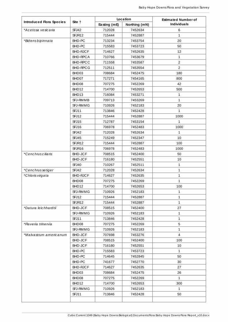
Baby Hope Downs Flora and Vegetation Survey
Cube:Current:1049 (Baby Hope Downs Biological):Documents:Flora:Baby Hope Downs Flora Report_v10.docx
Introduced Flora Species Site † Location Estimated Number of
Individuals Easting (mE) Northing (mN)
*Acetosa vesicaria SFJ42 712028 7452634 6
SFJR12 715444 7452887 1
*Bidens bipinnata BHD-PC 713234 7453754 20
BHD-PC 715583 7453723 50
BHD-RJCF 714627 7452635 12
BHD-RPCA 710766 7453679 1
BHD-RPCC 711558 7453587 2
BHD-RPCG 712511 7453554 2
BHD03 708684 7452475 180
BHD07 717271 7454165 800
BHD08 707275 7452269 42
BHD12 714700 7452653 500
BHD13 716084 7453271 1
SFJ-RMMB 709713 7453269 1
SFJ-RMMG 710926 7452183 20
SFJ11 713846 7452428 1
SFJ12 715444 7452887 1000
SFJ15 712787 7453154 1
SFJ16 706978 7452483 1000
SFJ42 712028 7452634 1
SFJ45 715249 7452347 10
SFJR12 715444 7452887 100
SFJR16 706978 7452483 1000
*Cenchrus ciliaris BHD-JCF 708515 7452400 50
BHD-JCF 716180 7452551 10
SFJ40 710267 7452511 1
*Cenchrus setiger SFJ42 712028 7452634 1
*Chloris virgata BHD-RJCF 714627 7452635 1
BHD08 707275 7452269 1
BHD12 714700 7452653 100
SFJ-RMMG 710926 7452183 1
SFJ12 715444 7452887 1
SFJR12 715444 7452887 1
*Datura leichhardtii BHD-JCF 708515 7452400 27
SFJ-RMMG 710926 7452183 1
SFJ11 713846 7452428 1
*Flaveria trinervia BHD08 707275 7452269 5
SFJ-RMMG 710926 7452183 1
*Malvastrum americanum BHD-JCF 707698 7453276 4
BHD-JCF 708515 7452400 100
BHD-JCF 716180 7452551 10
BHD-PC 715583 7453723 1
BHD-PC 714645 7452845 50
BHD-PC 741677 7452770 30
BHD-RJCF 714627 7452635 27
BHD03 708684 7452475 26
BHD08 707275 7452269 1
BHD12 714700 7452653 300
SFJ-RMMG 710926 7452183 1
SFJ11 713846 7452428 50

Baby Hope Downs Flora and Vegetation Survey
Cube:Current:1049 (Baby Hope Downs Biological):Documents:Flora:Baby Hope Downs Flora Report_v10.docx
Introduced Flora Species Site † Location Estimated Number of
Individuals Easting (mE) Northing (mN)
*Malvastrum americanum (continued)
SFJ16 706978 7452483 2
SFJ38 708053 7452530 1
SFJ42 712028 7452634 1
SFJR12 715444 7452887 100
SFJR16 706978 7452483 1
*Sigesbeckia orientalis BHD-PC 708731 7453348 3
BHD-RPCC 711558 7453587 6
SFJ-RMMG 710926 7452183 5
SFJ42 712028 7452634 1
*Vachellia farnesiana BHD-JCF 708515 7452400 2
SFJ-RMMG 710926 7452183 1 † Sites with “SFJ” codes are from sections of the Southern Flank to Jinidi Level 2 Flora and Vegetation Survey
(Biota 2012) that overlap the current study area.
Baby Hope Downs Flora and Vegetation Survey
Cube:Current:1049 (Baby Hope Downs Biological):Documents:Flora:Baby Hope Downs Flora Report_v10.docx
Appendix 7
Vegetation Mapping and Locations of Conservation Significant Flora


D1:
Ev Eucalyptus victrix scattered trees
D2:
EvAci Eucalyptus victrix scattered trees over Acacia citrinoviridis low woodland.
D3:
ExAciTloTp Eucalyptus xerothermica scattered low trees over Acacia citrinoviridis tall open shrubland over
Triodia longiceps (T. pungens) hummock grasslands.
D4:
ExApyPlTloTp Eucalyptus xerothermica scattered low trees over Acacia pyrifolia, Petalostylis labicheoides tall
open scrub over Triodia longiceps (T. pungens) open hummock grassland.
D5:
AanTpCHf Acacia ‘aneura’ low open woodland to low woodland over Triodia pungens scattered
hummock grassland with Chrysopogon fallax scattered tussock grasses.
D6: ElAbTp
Eucalyptus leucophloia subsp. leucophloia scattered low trees over Acacia bivenosa
scattered tall shrubland over Triodia pungens open hummock grassland.
Vegetation of Drainage Lines and Floodplains
G1:
CfElTHtCYaERImTp Corymbia ferriticola, Eucalyptus leucophloia subsp. leucophloia low open woodland over
Themeda triandra, Cymbopogon ambiguus, Eriachne mucronata very open tussock grassland
with Triodia pungens scattered hummock grasses.
Vegetation of Rocky Gorges and Gullies
H1:
ElTwTsps Eucalyptus leucophloia subsp. leucophloia low open woodland over Triodia wiseana, T. sp.
Shovelanna Hill (S. van Leeuwen 3835) open hummock grassland.
H2: ElTp
Eucalyptus leucophloia subsp. leucophloia scattered low trees over Triodia pungens open
hummock grassland.
H3:
CdElAiTsps Corymbia deserticola subsp. deserticola, Eucalyptus leucophloia subsp. leucophloia scattered
low trees over Acacia inaequilatera scattered tall shrubs over Triodia sp. Shovelanna Hill (S. van
Leeuwen 3835) hummock grassland.
Vegetation of Stony Hills and Foothills
P1:
AanAcaTp Acacia ‘aneura’, A. catenulata low open woodland to low open forest over Triodia pungens
scattered hummock grasses.
P2:
EgTspsTp Eucalyptus gamophylla scattered to very open mallee woodland over Triodia sp. Shovelanna
Hill (S. van Leeuwen 3835), T. pungens open hummock grassland.
Vegetation of Plains
Disturbed
Vegetation of Baby Hope Downs
Vegetation Type Descriptions for the
Baby Hope Downs Vegetation Maps
Legend Sheet 1
Areas cleared or disturbed.


Baby Hope Downs Flora and Vegetation Survey
Cube:Current:1049 (Baby Hope Downs Biological):Documents:Flora:Baby Hope Downs Flora Report_v10.docx
Appendix 8
Survey Effort – Foot Traverses and Mapping Note Locations


Baby Hope Downs Flora and Vegetation Survey
Cube:Current:1049 (Baby Hope Downs Biological):Documents:Flora:Baby Hope Downs Flora Report_v10.docx


Baby Hope Downs Flora and Vegetation Survey
Cube:Current:1049 (Baby Hope Downs Biological):Documents:Flora:Baby Hope Downs Flora Report_v10.docx
Appendix 9
Vegetation Condition Mapping and Introduced Flora Locations


Baby Hope Downs Flora and Vegetation Survey
Cube:Current:1049 (Baby Hope Downs Biological):Documents:Flora:Baby Hope Downs Flora Report_v10.docx


Baby Hope Downs Flora and Vegetation Survey
Cube:Current:1049 (Baby Hope Downs Biological):Documents:Flora:Baby Hope Downs Flora Report_v10.docx
Appendix 10
Raw Data for Quadrats and Relevés from the Current Study


Baby Hope Downs Site BHD01
Described by JCFCA Date 28-Oct-14 Type Quadrat 50m x 50m
MGA Zone 50 709587 mE 7453248 mN
Habitat Hill slope below free face on a range of hills.
Soil Dark reddish brown (2.5YR 3/4) sandy clay loam with 1-25% outcropping, 1-25% cover of boulders, 1-25% cover of cobbles, 26-50% cover of pebbles and 26-50% cover of gravel.
Rock Type Ironstone.
Vegetation Eucalyptus leucophloia subsp. leucophloia, Corymbia hamersleyana low open woodland over Acacia hamersleyensis tall open shrubland over Cymbopogon ambiguus scattered tussock grasses with Triodia pungens open hummock grassland.
Veg Condition Excellent.
Fire Age Very long unburnt.
Species Cover Height Specimen Acacia hamersleyensis 3 190 cm BHD01-02 Amphipogon sericeus 0.1 20 cm BHD01-09 Aristida ingrata 0.1 60 cm BHD01-04 Cheilanthes sieberi subsp. pseudovellea 0.1 15 cm BHD01-10 Corchorus lasiocarpus subsp. parvus 0.1 50 cm BHD01-08 Corymbia hamersleyana 2 320 cm Cymbopogon ambiguus 1 70 cm BHD01-07 Duperreya commixta 0.1 210 cm Dysphania rhadinostachya subsp. inflata 0.1 10 cm BHD01-06 Eremophila jucunda subsp. pulcherrima 0.1 20 cm BHD01-03 Eriachne mucronata (typical form) 0.1 30 cm Eriachne pulchella 0.1 15 cm Eucalyptus leucophloia subsp. leucophloia 1 400 cm Goodenia stobbsiana 0.1 30 cm Hakea chordophylla 0.1 80 cm Jasminum didymum subsp. lineare 0.1 50 cm Polycarpaea holtzei 0.1 1 cm Polycarpaea longiflora 0.1 15 cm Ptilotus obovatus 0.1 60 cm Schizachyrium fragile 0.1 15 cm Senna glutinosa subsp. glutinosa 0.1 120 cm Sida sp. Shovelanna Hill (S. van Leeuwen 3842) 0.2 30 cm BHD01-05, -11 Solanum lasiophyllum 0.1 30 cm Triodia pungens 20 60 cm BHD01-01

Baby Hope Downs Site BHD02
Described by PACEF Date 27-Oct-14 Type Quadrat 50m x 50m
MGA Zone 50 708847 mE 7453379 mN
Habitat Steep rocky north facing upper slope of range, north of a broad floodplain.
Soil Dark reddish brown (2.5YR 3/4) clay loam with 26-50% outcropping, 1-25% cover of large boulders, 1-25% cover of boulders, 26-50% cover of cobbles, 1-25% cover of pebbles and 1-25% cover of gravel.
Rock Type Ironstone.
Vegetation Eucalyptus leucophloia subsp. leucophloia, Corymbia hamersleyana low open woodland over Triodia wiseana (T. pungens) open hummock
Veg Condition Excellent.
Fire Age No sign of recent fire.
Notes 707m elevation.
Species Cover Height Specimen Notes Acacia hamersleyensis 0.1 230 cm Acacia pruinocarpa 0.1 150 cm Aristida holathera var. holathera 0.1 15 cm Corchorus lasiocarpus subsp. parvus 0.1 40 cm BHD02-04 Corymbia hamersleyana 2 450 cm Cymbopogon ambiguus 0.1 70 cm BHD02-05 Cyperus cunninghamii subsp. cunninghamii
0.1 20 cm BHD02-08
Dodonaea viscosa subsp. mucronata 0.1 170 cm BHD02-07 Duperreya commixta 0.1 110 cm Dysphania rhadinostachya 0.1 10 cm Dead; subsp. not determined. Eremophila jucunda subsp. pulcherrima 0.1 130 cm BHD02-06 Eriachne mucronata (typical form) 0.1 30 cm Eriachne pulchella 0.1 10 cm Eucalyptus leucophloia subsp. leucophloia
2 500 cm
Goodenia stobbsiana 0.1 40 cm Hakea chordophylla 0.1 120 cm Jasminum didymum subsp. lineare 0.1 130 cm Ptilotus obovatus 0.1 40 cm Senna artemisioides subsp. oligophylla 0.1 80 cm Senna glutinosa subsp. glutinosa 0.1 120 cm Sida sp. Shovelanna Hill (S. van Leeuwen 3842)
0.1 20 cm
Solanum lasiophyllum 0.1 15 cm Triodia pungens 1 40 cm BHD02-01 Triodia wiseana 28 80 cm BHD02-02

Baby Hope Downs Site BHD03
Described by JCFCA Date 28-Oct-14 Type Quadrat 50m x 50m
MGA Zone 50 708653 mE 7452488 mN
Habitat Creek bed in a broad floodplain.
Soil Dark reddish brown silty clay loam with 1-25% cover of cobbles, 1-25% cover of pebbles and 1-25% cover of gravel.
Rock Type Ironstone.
Vegetation Eucalyptus victrix open woodland over Acacia pyrifolia var. pyrifolia scattered low shrubs.
Veg Condition Very Good; evidence of cattle and presence of *Bidens bipinnata and *Malvastrum americanum.
Fire Age No sign of recent fire.
Species Cover Height Specimen Notes Acacia citrinoviridis 0.1 200 cm Acacia maitlandii 0.1 120 cm Acacia pteraneura 0.1 340 cm BHD03-01 Acacia pyrifolia var. pyrifolia 1 80 cm BHD03-21 Acrachne racemosa 0.1 30 cm BHD03-08B Androcalva luteiflora 0.1 130 cm Aristida contorta 0.1 10 cm Bidens bipinnata 0.1 20 cm 180 individuals Boerhavia sp. 0.1 2 cm BHD03-20 Insufficient material for further
determination. Cleome viscosa 0.1 30 cm Cymbopogon procerus 0.1 60 cm Dicladanthera forrestii 0.1 30 cm BHD03-16 Digitaria ctenantha 0.1 20 cm BHD03-06 Duperreya commixta 0.1 210 cm Enchylaena tomentosa var. tomentosa 0.1 30 cm BHD03-09 Enneapogon robustissimus 0.1 20 cm BHD03-05 Enteropogon ramosus 0.1 80 cm BHD03-08A Eremophila longifolia 0.1 210 cm Eriachne mucronata (typical form) 0.1 40 cm Eucalyptus victrix 9 1500 cm Eulalia aurea 0.1 80 cm BHD03-03 Evolvulus alsinoides var. decumbens 0.1 10 cm Glycine canescens 0.1 40 cm BHD03-12 Hybanthus aurantiacus 0.1 30 cm Indigofera georgei 0.1 110 cm BHD03-17 Isotropis forrestii 0.1 90 cm BHD03-18 Jasminum didymum subsp. lineare 0.1 240 cm Malvastrum americanum 0.1 40 cm 26 individuals Oldenlandia crouchiana 0.1 10 cm Petalostylis labicheoides 0.1 310 cm Phyllanthus maderaspatensis 0.1 20 cm BHD03-07 Polycarpaea longiflora 0.1 30 cm Pterocaulon sphacelatum 0.1 30 cm BHD03-10 Ptilotus astrolasius 0.1 40 cm Ptilotus obovatus 0.1 60 cm Rhagodia eremaea 0.1 50 cm Rhynchosia minima 0.1 10 cm Rutidosis helichrysoides subsp. helichrysoides
0.1 40 cm BHD03-13
Salsola australis 0.1 40 cm Setaria dielsii 0.1 30 cm BHD03-14 Sida fibulifera 0.1 20 cm Tephrosia rosea var. Fortescue creeks (M.I.H. Brooker 2186)
0.1 60 cm BHD03-02
Themeda triandra 0.1 80 cm Trichodesma zeylanicum var. zeylanicum
0.1 20 cm

Species Cover Height Specimen Notes Triodia longiceps 0.1 60 cm BHD03-19 Triodia pungens 0.1 40 cm BHD03-04

Baby Hope Downs Site BHD04
Described by PACEF Date 28-Oct-14 Type Quadrat 50m x 50m
MGA Zone 50 710349 mE 7454065 mN
Habitat Hill crest and upper slope of a range of low rocky hills.
Soil Dark reddish brown (2.5 YR 2.5/3) fine sandy loam with 51-75% cover of cobbles, 51-75% cover of pebbles and 1-25% cover of gravel.
Rock Type Ironstone.
Vegetation Corymbia hamersleyana, Eucalyptus leucophloia subsp. leucophloia low open woodland over Petalostylis labicheoides tall open shrubland over Acacia hilliana low open shrubland over Triodia wiseana open hummock grassland.
Veg Condition Excellent.
Fire Age No sign of recent fire.
Notes 757m elevation.
Species Cover Height Specimen Notes Acacia ? hilliana x hamersleyensis 0.1 60 cm BHD04-03 Determined by M. Trudgen. Acacia adoxa var. adoxa 0.1 25 cm Acacia hamersleyensis 0.1 450 cm Acacia hilliana 4 50 cm Acacia pyrifolia var. pyrifolia 0.1 300 cm Amphipogon sericeus 0.1 30 cm Aristida holathera var. holathera 0.1 20 cm BHD04-05 Codonocarpus cotinifolius 0.1 50 cm Corymbia hamersleyana 1.5 450 cm Cymbopogon obtectus 0.1 30 cm BHD04-06 Enneapogon polyphyllus 0.1 30 cm Eriachne lanata 0.1 40 cm BHD04-02 Eriachne mucronata (typical form) 0.1 30 cm Eriachne pulchella 0.1 5 cm Eucalyptus leucophloia subsp. leucophloia 1 450 cm Goodenia stobbsiana 0.1 40 cm Goodenia triodiophila 0.1 20 cm BHD04-04 Hakea chordophylla 0.1 400 cm Indigofera monophylla 0.1 25 cm Petalostylis labicheoides 2 350 cm Ptilotus astrolasius 0.1 30 cm Ptilotus calostachyus 0.1 70 cm Ptilotus obovatus 0.1 40 cm Solanum lasiophyllum 0.1 50 cm Triodia wiseana 17 60 cm BHD04-01

Baby Hope Downs Site BHD05
Described by JCFCA Date 28-Oct-14 Type Quadrat 50m x 50m
MGA Zone 50 714486 mE 7453708 mN
Habitat South facing mid slope of range of hills.
Soil Dark reddish brown (2.5YR 2.5/3) sandy clay loam with 1-25% outcropping ironstone, 1-25% cover of cobble, 1-25% cover of pebbles and 1-25% cover of gravel.
Rock Type Ironstone.
Vegetation Eucalyptus leucophloia subsp. leucophloia, Corymbia hamersleyana low open woodland over Acacia hamersleyensis tall open shrubland over Mirbelia viminalis open shrubland over Triodia wiseana, T. sp. Shovelanna Hill (S. van Leeuwen 3835) hummock grassland.
Veg Condition Excellent.
Fire Age No sign of recent fire.
Species Cover Height Specimen Notes Acacia hamersleyensis 2 350 cm BHD05-07 Acacia maitlandii 0.1 350 cm Acacia pyrifolia var. pyrifolia 0.1 90 cm BHD05-08 Amphipogon sericeus 0.1 20 cm BHD05-02 Corymbia hamersleyana 3 410 cm BHD05-03 Eriachne pulchella 0.1 10 cm Eucalyptus leucophloia subsp. leucophloia 2 490 cm Goodenia stobbsiana 0.1 10 cm BHD05-05 Grevillea wickhamii 0.1 420 cm Sterile. Hakea chordophylla 0.1 200 cm Mirbelia viminalis 4 160 cm BHD05-01 Petalostylis labicheoides 0.1 270 cm BHD05-06 Stemodia grossa 0.1 10 cm Triodia sp. Shovelanna Hill (S. van Leeuwen 3835) 2 20 cm BHD05-04 Triodia wiseana 55 50 cm

Baby Hope Downs Site BHD06
Described by PACEF Date 28-Oct-14 Type Quadrat 50m x 50m
MGA Zone 50 714972 mE 7454562 mN
Habitat Upper slope and crest of a low rocky hill.
Soil Dark reddish brown (2.5YR 3/4) loamy sand with 26-50% cover of cobbles, 51-75% cover of pebbles and 1-25% cover of gravel.
Rock Type Ironstone.
Vegetation Eucalyptus leucophloia subsp. leucophloia (Eucalyptus gamophylla) low open woodland over Triodia sp. Shovelanna Hill (S. van Leeuwen 3835) (T. wiseana) open hummock grassland.
Veg Condition Excellent.
Fire Age No sign of recent fire.
Species Cover Height Specimen Acacia hamersleyensis 0.1 250 cm Acacia pyrifolia var. pyrifolia 0.1 180 cm Acacia spondylophylla 0.1 90 cm Amphipogon sericeus 0.1 20 cm Cassytha capillaris 0.1 25 cm Corymbia hamersleyana 0.1 400 cm Eucalyptus gamophylla 0.5 450 cm Eucalyptus leucophloia subsp. leucophloia 2 450 cm Fimbristylis dichotoma 0.1 10 cm BHD06-02 Goodenia stobbsiana 0.1 10 cm Goodenia triodiophila 0.1 20 cm BHD06-01 Hakea chordophylla 0.1 350 cm Ptilotus calostachyus 0.1 80 cm Senna glutinosa subsp. glutinosa 0.1 100 cm Triodia sp. Shovelanna Hill (S. van Leeuwen 3835) 12 40 cm Triodia wiseana 5 60 cm

Baby Hope Downs Site BHD07
Described by JCFCA Date 29-Oct-14 Type Quadrat 50m x 50m
MGA Zone 50 717236 mE 7454184 mN
Habitat Stony plain north of a broad floodplain.
Soil Dark reddish brown (2.5YR 3/6) silty clay loam with 1-25% cover of pebbles and 1-25% cover of gravel.
Rock Type Ironstone.
Vegetation Acacia aptaneura, A. catenulata subsp. occidentalis, A. pruinocarpa tall open shrubland.
Veg Condition Very Good; presence of *Bidens bipinnata.
Fire Age No sign of recent fire.
Species Cover Height Specimen Notes Abutilon otocarpum 0.1 20 cm BHD07-04 Acacia aptaneura 3 650 cm BHD07-01 Acacia catenulata subsp. occidentalis 3 450 cm BHD07-16 Acacia catenulata subsp. occidentalis 1 750 cm BHD07-15 Acacia pruinocarpa 2 400 cm Acacia pyrifolia var. pyrifolia 0.1 110 cm BHD07-17 Alternanthera nodiflora 0.1 15 cm Aristida contorta 0.1 40 cm Aristida inaequiglumis 0.1 80 cm BHD07-11 Bidens bipinnata 0.1 20 cm 800 individuals Cleome viscosa 0.1 20 cm Cucumis variabilis 0.1 5 cm Digitaria brownii 0.1 50 cm BHD07-08 Enneapogon caerulescens 0.1 10 cm BHD07-09 Enneapogon polyphyllus 0.1 10 cm BHD07-02 Eremophila forrestii subsp. forrestii 0.1 170 cm Evolvulus alsinoides var. villosicalyx 0.1 10 cm Iseilema membranaceum 0.1 10 cm BHD07-14 Jasminum didymum subsp. lineare 0.1 170 cm Maireana planifolia 0.1 30 cm BHD07-05 Polycarpaea corymbosa var. corymbosa 0.1 10 cm Ptilotus astrolasius 0.1 60 cm Ptilotus helipteroides 0.1 25 cm BHD07-10 Ptilotus obovatus 0.1 15 cm Rhagodia eremaea 0.1 110 cm Sclerolaena cornishiana 0.1 15 cm BHD07-03 Senna artemisioides subsp. oligophylla 0.1 110 cm Sida arenicola 0.1 120 cm BHD07-07 Sida fibulifera 0.1 20 cm Sida platycalyx 0.1 40 cm BHD07-06 Solanum lasiophyllum 0.1 10 cm BHD07-13 Sporobolus australasicus 0.1 10 cm Triodia pungens 0.1 60 cm BHD07-12 Sterile.

Baby Hope Downs Site BHD08
Described by PACEF Date 29-Oct-14 Type Quadrat 25m x 100m
MGA Zone 50 707221 mE 7452271 mN
Habitat Bed and banks of a moderate creekline, flowing approximately east-west through a broad floodplain.
Soil Dark reddish brown (2.5YR 2.5/3) silty clay loam with 1-25% cover of cobbles, 51-75% cover of pebbles and 51-75% cover of gravel.
Rock Type Ironstone.
Vegetation Eucalyptus victrix low open woodland over Bothriochloa ewartiana, Themeda triandra, Cymbopogon procerus, Eulalia aurea, Enneapogon robustissimus very open tussock grassland with Triodia longiceps very open hummock grassland.
Veg Condition Very Good; evidence of cattle and presence of *Bidens bipinnata, *Chloris virgata, *Flaveria trinervia and *Malvastrum americanum.
Fire Age No sign of recent fire.
Species Cover Height Specimen Notes Acacia aptaneura 0.1 400 cm BHD08-12 Acacia bivenosa 0.1 100 cm Acacia maitlandii 0.1 230 cm Acacia pruinocarpa 0.1 220 cm Acacia pyrifolia var. pyrifolia 0.1 100 cm Alternanthera nana 0.1 10 cm BHD08-06 Aristida contorta 0.1 30 cm Aristida holathera var. holathera 0.1 20 cm Bidens bipinnata 0.1 20 cm 42 individuals Bothriochloa ewartiana 3 120 cm BHD08-08 Brachyachne convergens 0.1 15 cm Centipeda minima subsp. macrocephala 0.1 10 cm BHD08-14 Chloris virgata 0.1 95 cm BHD08-02 Chrysopogon fallax 0.1 140 cm Cleome viscosa 0.1 50 cm Cymbopogon procerus 1 140 cm Dicladanthera forrestii 0.1 25 cm Dipteracanthus australasicus subsp. australasicus 0.1 15 cm Duperreya commixta 0.1 240 cm Enneapogon lindleyanus 0.1 30 cm BHD08-07 Enneapogon polyphyllus 0.1 30 cm Enneapogon robustissimus 1 70 cm Enteropogon ramosus 0.1 100 cm BHD08-01 Eragrostis cumingii 0.1 40 cm Eragrostis tenellula 0.1 25 cm Eremophila longifolia 0.1 40 cm Eriachne mucronata (typical form) 0.1 50 cm Eriachne tenuiculmis 0.1 80 cm BHD08-09 Eucalyptus victrix 7 1000 cm Eulalia aurea 1 110 cm Euphorbia australis var. subtomentosa 0.1 10 cm BHD08-13 Euphorbia boophthona 0.1 30 cm Evolvulus alsinoides var. decumbens 0.1 25 cm Evolvulus alsinoides var. villosicalyx 0.1 15 cm Flaveria trinervia 0.1 20 cm 5 individuals Goodenia muelleriana 0.1 30 cm Heliotropium cunninghamii 0.1 25 cm BHD08-10 Hybanthus aurantiacus 0.1 20 cm Indigofera georgei 0.1 45 cm Isotropis forrestii 0.1 100 cm BHD08-16 Malvastrum americanum 0.1 25 cm 1 individual Melhania oblongifolia 0.1 20 cm Paraneurachne muelleri 0.1 70 cm Phyllanthus maderaspatensis 0.1 50 cm Polycarpaea longiflora 0.1 20 cm

Species Cover Height Specimen Notes Polymeria ambigua 0.1 10 cm Pterocaulon sphacelatum 0.1 20 cm BHDRPCC03= Ptilotus obovatus 0.1 50 cm Rhagodia eremaea 0.1 90 cm Rhynchosia minima 0.1 30 cm Salsola australis 0.1 10 cm Santalum lanceolatum 0.1 90 cm Sida fibulifera 0.1 15 cm BHD08-04 sens. lat. Sporobolus australasicus 0.1 10 cm Stenopetalum decipiens 0.1 50 cm BHD08-05 Tephrosia rosea var. Fortescue creeks (M.I.H. Brooker 2186)
0.1 60 cm
Themeda triandra 2 95 cm Triodia longiceps 5 45 cm BHD08-03 Triodia pungens 0.1 40 cm

Baby Hope Downs Site BHD09
Described by JCFCA Date 29-Oct-14 Type Quadrat 50m x 50m
MGA Zone 50 716444 mE 7454517 mN
Habitat Lower south facing slope of undulating hills.
Soil Dark reddish brown loamy sand with 25-60% cover of cobbles, 25-60% cover of pebbles and 1-25% cover of gravel.
Rock Type Ironstone.
Vegetation Eucalyptus leucophloia subsp. leucophloia low open woodland over Acacia spondylophylla low open shrubland over Triodia wiseana open hummock grassland.
Veg Condition Excellent.
Fire Age No sign of recent fire.
Notes Triodia sp. Shovelanna Hill dominant further upslope.
Species Cover Height Specimen Notes Acacia adsurgens 0.1 130 cm BHD09-02 Acacia monticola 0.1 80 cm Acacia pruinocarpa 0.1 270 cm Acacia spondylophylla 4 60 cm Enneapogon polyphyllus 0.1 30 cm BHD09-03 Eriachne pulchella 0.1 10 cm Eucalyptus leucophloia subsp. leucophloia 3 590 cm Euphorbia australis var. hispidula 0.1 5 cm BHD09-04 Gossypium robinsonii 0.1 150 cm Grevillea wickhamii 0.1 230 cm Sterile. Hakea chordophylla 0.1 240 cm Hybanthus aurantiacus 0.1 40 cm Petalostylis labicheoides 0.1 310 cm BHD09-06 Ptilotus calostachyus 0.1 40 cm Santalum lanceolatum 0.1 160 cm BHD09-01 Schizachyrium fragile 0.1 10 cm Solanum horridum 0.1 20 cm BHD09-05 Triodia pungens 0.1 20 cm Sterile. Triodia sp. Shovelanna Hill (S. van Leeuwen 3835) 0.1 20 cm Triodia wiseana 20 40 cm

Baby Hope Downs Site BHD10
Described by PACEF Date 31-Oct-14 Type Quadrat 50m x 50m
MGA Zone 50 708722 mE 7452829 mN
Habitat Low spur of foothills of range, north of a broad floodplain.
Soil Dark reddish brown (2.5YR 3/3) fine sandy loam with 51-75% cover of cobbles, 26-50% cover of pebbles and 1-25% cover of gravel.
Rock Type Ironstone.
Vegetation Corymbia deserticola subsp. deserticola scattered low trees over Acacia inaequilatera tall open shrubland over Triodia sp. Shovelanna Hill (S. van Leeuwen 3835) very open hummock grassland.
Veg Condition Very Good; small area of disturbance (clearing) in the northwest corner.
Fire Age Burnt <1 year ago.
Species Cover Height Specimen Notes Acacia bivenosa 0.1 20 cm Acacia inaequilatera 2 270 cm Acacia pruinocarpa 0.1 100 cm Amphipogon sericeus 0.1 45 cm Aristida contorta 0.1 25 cm Aristida holathera var. holathera 0.1 20 cm Codonocarpus cotinifolius 0.1 120 cm Corymbia deserticola subsp. deserticola 1 400 cm Cymbopogon obtectus 0.1 70 cm Duperreya commixta 0.1 100 cm Enneapogon caerulescens 0.1 15 cm Enneapogon lindleyanus 0.1 50 cm Enneapogon polyphyllus 0.1 40 cm Eremophila longifolia 0.1 100 cm Eriachne mucronata (typical form) 0.1 45 cm BHD10-01 Eriachne pulchella 0.1 10 cm Eucalyptus gamophylla 0.1 130 cm Euphorbia boophthona 0.1 20 cm Fimbristylis dichotoma 0.1 20 cm Goodenia microptera 0.1 10 cm Goodenia stobbsiana 0.1 30 cm Goodenia triodiophila 0.1 40 cm BHD10-03 Hakea chordophylla 0.1 100 cm Heliotropium inexplicitum 0.1 8 cm BHD10-10 Heliotropium tenuifolium 0.1 25 cm BHD10-02 Hibiscus coatesii 0.1 60 cm BHD10-06 Hibiscus sturtii var. campylochlamys 0.1 15 cm BHD10-04 Hybanthus aurantiacus 0.1 40 cm Indigofera monophylla 0.1 40 cm Jasminum didymum subsp. lineare 0.1 70 cm Oldenlandia crouchiana 0.1 20 cm Paraneurachne muelleri 0.1 40 cm Paspalidium clementii 0.1 15 cm BHD10-05 Phyllanthus erwinii 0.1 10 cm Ptilotus calostachyus 0.1 90 cm Ptilotus helipteroides 0.1 40 cm Ptilotus nobilis subsp. nobilis 0.1 60 cm Ptilotus obovatus 0.1 45 cm Ptilotus rotundifolius 0.1 60 cm Scaevola parvifolia subsp. pilbarae 0.1 40 cm Schizachyrium fragile 0.1 30 cm Senna artemisioides subsp. helmsii 0.1 60 cm Senna artemisioides subsp. x sturtii x 0.1 70 cm BHD10-08 Unknown hybrid;
determined by M. Trudgen.
Senna ferraria 0.1 60 cm BHD10-09 Senna glutinosa subsp. glutinosa 0.1 120 cm

Species Cover Height Specimen Notes Senna glutinosa subsp. x luerssenii 0.1 130 cm Senna notabilis 0.1 50 cm Sida sp. Excedentifolia (J.L. Egan 1925) 0.1 40 cm BHD10-07 Streptoglossa decurrens 0.1 50 cm Tephrosia oxalidea 0.1 2 cm Themeda triandra 0.1 90 cm Trachymene oleracea subsp. oleracea 0.1 70 cm Triodia pungens 0.1 40 cm Triodia sp. Shovelanna Hill (S. van Leeuwen 3835) 6 25 cm Cover would be ~12% if
unburnt. Velleia connata 0.1 20 cm

Baby Hope Downs Site BHD11
Described by JCFCA Date 29-Oct-14 Type Quadrat 50m x 50m
MGA Zone 50 711338 mE 7453713 mN
Habitat North facing hill crest on a range.
Soil Dark reddish brown sandy clay loam with 1-25% outcropping ironstone, 26-50% cover of cobbles, 26-50% cover of pebbles and 1-25% cover of gravel.
Rock Type Ironstone.
Vegetation Eucalyptus leucophloia subsp. leucophloia low open woodland over Triodia wiseana open hummock grassland.
Veg Condition Excellent.
Fire Age Very long unburnt.
Species Cover Height Specimen Acacia tenuissima 0.1 120 cm BHD11-02 Amphipogon sericeus 0.1 20 cm Codonocarpus cotinifolius 0.1 450 cm Eriachne lanata 0.1 20 cm BHD11-01 Eriachne mucronata (typical form) 0.1 30 cm Eucalyptus leucophloia subsp. leucophloia 2 450 cm Goodenia stobbsiana 0.1 30 cm Ptilotus astrolasius 0.1 40 cm Ptilotus calostachyus 0.1 60 cm Ptilotus obovatus 0.1 60 cm Senna glutinosa subsp. glutinosa 0.1 130 cm Triodia wiseana 15 30 cm

Baby Hope Downs Site BHD12
Described by PACEF Date 31-Oct-14 Type Quadrat 50m x 50m
MGA Zone 50 714674 mE 7452675 mN
Habitat Moderate creekline within a broad floodplain with rocky drainage channels.
Soil Dark reddish brown (2.5YR 2.5/4) fine sandy clay loam with 1-25% cover of cobbles, 1-25% cover of pebbles and 1-25% cover of gravel.
Rock Type Ironstone.
Vegetation Eucalyptus victrix, Acacia citrinoviridis low open woodland over *Chloris virgata, Enteropogon ramosus very open tussock grassland with Triodia longiceps, T. pungens very open hummock grassland.
Veg Condition Very Good; presence of *Bidens bipinnata, *Chloris virgata and *Malvastrum americanum.
Fire Age No sign of recent fire.
Species Cover Height Specimen Notes Acacia citrinoviridis 14 800 cm Acacia pruinocarpa 0.1 220 cm Acacia pteraneura 0.1 700 cm BHD12-08 Acacia tetragonophylla 0.1 210 cm Alternanthera nana 0.1 25 cm Alternanthera nodiflora 0.1 25 cm Bidens bipinnata 0.1 25 cm 500 individuals Boerhavia sp. 0.1 5 cm Dead. Chloris virgata 4 140 cm BHD12-05 Chrysopogon fallax 0.1 120 cm Cleome viscosa 0.1 20 cm Clerodendrum floribundum var. angustifolium 0.1 320 cm Corchorus crozophorifolius 0.1 90 cm Dicladanthera forrestii 0.1 25 cm Digitaria brownii 0.1 60 cm Digitaria ctenantha 0.1 20 cm Dipteracanthus australasicus subsp. australasicus 0.1 25 cm Duperreya commixta 0.1 120 cm Dysphania rhadinostachya subsp. rhadinostachya 0.1 20 cm BHD12-06 Enchylaena tomentosa var. tomentosa 0.1 30 cm Enneapogon lindleyanus 0.1 30 cm BHD12-03 Enneapogon polyphyllus 0.1 30 cm Enneapogon robustissimus 0.1 120 cm Enteropogon ramosus 1 90 cm Eucalyptus victrix 1 900 cm Eulalia aurea 0.1 100 cm Euphorbia boophthona 0.1 80 cm Evolvulus alsinoides var. villosicalyx 0.1 20 cm Glycine canescens 0.1 120 cm Heliotropium cunninghamii 0.1 20 cm BHD12-01 Hybanthus aurantiacus 0.1 30 cm Isotropis forrestii 0.1 120 cm BHD12-09 Maireana planifolia 0.1 60 cm Maireana villosa 0.1 35 cm Malvastrum americanum 0.1 35 cm 300 individuals Melhania oblongifolia 0.1 30 cm Pluchea dentex 0.1 30 cm Ptilotus nobilis subsp. nobilis 0.1 25 cm Ptilotus obovatus 0.1 60 cm Rhagodia eremaea 0.1 80 cm Rhynchosia minima 0.1 30 cm Salsola australis 0.1 15 cm Santalum spicatum 0.1 300 cm Sclerolaena cornishiana 0.1 35 cm BHD12-07 Setaria dielsii 0.1 70 cm BHD12-04 Sida fibulifera 0.1 20 cm sens. lat. Sida sp. spiciform panicles (E. Leyland s.n. 14/8/90) 0.1 110 cm

Species Cover Height Specimen Notes Solanum lasiophyllum 0.1 90 cm Sporobolus australasicus 0.1 15 cm Themeda triandra 1 120 cm Trichodesma zeylanicum var. zeylanicum 0.1 120 cm Triodia longiceps 2 60 cm Triodia pungens 1 40 cm

Baby Hope Downs Site BHD13
Described by JCFCA Date 29-Oct-14 Type Quadrat 50m x 50m
MGA Zone 50 716062 mE 7453298 mN
Habitat Stony mulga floodplain north of a moderate creekline.
Soil Dark reddish brown silty clay loam with 1-25% cover of cobbles, 1-25% cover of pebbles and 1-25% cover of gravel.
Rock Type Ironstone.
Vegetation Acacia aptaneura, A. sibirica, A. pruinocarpa tall shrubland over Eremophila forrestii subsp. forrestii open shrubland over Triodia pungens very open hummock grassland.
Veg Condition Very Good; presence of *Bidens bipinnata.
Fire Age No sign of recent fire.
Species Cover Height Specimen Notes Abutilon lepidum 0.1 15 cm BHD13-06 Abutilon macrum 0.1 30 cm BHD13-15 Abutilon otocarpum 0.1 5 cm BHD13-14 Acacia aff. aneura 0.1 40 cm BHD13-10 Juvenile; determined by M.
Trudgen. Acacia aptaneura 9 450 cm BHD13-03 Acacia pruinocarpa 1 600 cm BHD13-16 Acacia pruinocarpa 1 450 cm Acacia sibirica 2 460 cm BHD13-04 Aristida contorta 0.1 10 cm Bidens bipinnata 0.1 20 cm Cleome viscosa 0.1 60 cm Digitaria brownii 0.1 20 cm BHD07-08= Digitaria ctenantha 0.1 25 cm BHD13-11 Duperreya commixta 0.1 20 cm Enneapogon caerulescens 0.1 20 cm BHD07-09= Enneapogon polyphyllus 0.1 20 cm BHD07-02= Eremophila forrestii subsp. forrestii 2 200 cm BHD13-05 Eriachne pulchella 0.1 5 cm Evolvulus alsinoides var. villosicalyx 0.1 5 cm Hakea lorea subsp. lorea 0.1 210 cm Hibiscus burtonii 0.1 80 cm BHD13-08 Maireana villosa 0.1 60 cm BHD13-01 Ptilotus helipteroides 0.1 15 cm BHD07-10= Ptilotus obovatus 0.1 20 cm Rhagodia eremaea 0.1 130 cm Santalum lanceolatum 0.1 110 cm BHD13-13 Senna artemisioides subsp. helmsii 0.1 160 cm BHD13-17 Senna glutinosa subsp. x luerssenii 0.1 180 cm BHD13-09 Sida arenicola 0.1 80 cm BHD07-07= Sida fibulifera 0.1 10 cm sens. lat. Sida sp. spiciform panicles (E. Leyland s.n. 14/8/90)
0.1 110 cm BHD13-12
Solanum lasiophyllum 0.1 30 cm Sporobolus australasicus 0.1 10 cm Themeda triandra 0.1 80 cm Triodia pungens 3 40 cm BHD13-02 Triodia sp. Shovelanna Hill (S. van Leeuwen 3835)
0.1 20 cm BHD13-07


Baby Hope Downs Site BHD14
Described by JCFCA Date 30-Oct-14 Type Quadrat 62.5m x 40m
MGA Zone 50 716227 mE 7452570 mN
Habitat Floodplain adjacent to minor drainage.
Soil Dark reddish brown silty clay loam with 1-25% cover of cobbles, 26-50% cover of pebbles and 26-50% cover of gravel.
Rock Type Ironstone.
Vegetation Acacia aptaneura, A. aptaneura x, A. pruinocarpa tall shrubland over Eremophila forrestii subsp. forrestii scattered low shrubs over Triodia pungens open hummock grassland.
Veg Condition Excellent.
Fire Age No sign of recent fire.
Notes Low cattle disturbance.
Species Cover Height Specimen Notes Acacia aptaneura 8 280 cm BHD14-02 Acacia aptaneura x 2 210 cm BHD14-03 Acacia bivenosa 0.1 240 cm Acacia citrinoviridis 0.1 180 cm Acacia pruinocarpa 3 290 cm Acacia pyrifolia var. pyrifolia 0.1 160 cm BHD14-07 Acacia sibirica 0.1 210 cm BHD14-09 Anthobolus leptomerioides 0.1 70 cm Chrysopogon fallax 0.1 60 cm Corchorus crozophorifolius 0.1 60 cm BHD14-10 Digitaria brownii 0.1 30 cm BHD14-05 Duperreya commixta 0.1 100 cm Enneapogon lindleyanus 0.1 20 cm BHD14-17 Enneapogon polyphyllus 0.1 20 cm BHD14-16 Enneapogon robustissimus 0.1 30 cm BHD14-11 Eremophila forrestii subsp. forrestii 1 80 cm BHD14-04 Eriachne pulchella 0.1 1 cm Eucalyptus gamophylla 0.1 210 cm Gossypium australe 0.1 90 cm Heliotropium heteranthum 0.1 1 cm BHD14-18 Hibiscus burtonii 0.1 30 cm BHD14-14 Hibiscus sturtii var. platychlamys 0.1 30 cm BHD14-15 Hibiscus sturtii var. platychlamys 0.1 20 cm BHD14-13 Ptilotus helipteroides 0.1 10 cm Ptilotus nobilis subsp. nobilis 0.1 60 cm Ptilotus obovatus 0.1 80 cm Rhagodia eremaea 0.1 120 cm Sclerolaena cornishiana 0.1 30 cm BHD14-12 Senna artemisioides subsp. oligophylla x subsp. helmsii 0.1 120 cm BHD14-06 Senna glutinosa subsp. x luerssenii 0.1 210 cm BHD14-08 Senna glutinosa subsp. x luerssenii 0.1 120 cm BHD14-20 Sida fibulifera 0.1 20 cm sens. lat. Sida sp. spiciform panicles (E. Leyland s.n. 14/8/90) 0.1 90 cm Solanum lasiophyllum 0.1 60 cm BHD14-19 Sporobolus australasicus 0.1 20 cm Themeda triandra 0.1 80 cm Triodia pungens 12 60 cm BHD14-01


Baby Hope Downs Site BHD15
Described by JCFPA Date 30-Oct-14 Type Quadrat 50m x 50m
MGA Zone 50 713766 mE 7453717 mN
Habitat Elevated valley floor between two rocky hills.
Soil Dark reddish brown loamy sand with 1-25% outcropping ironstone, 26-50% cover of cobbles, 26-50% cover of pebbles and 26-50% cover of gravel.
Rock Type Ironstone.
Vegetation Eucalyptus leucophloia subsp. leucophloia low open woodland over Acacia bivenosa, A. inaequilatera scattered shrubs over Triodia pungens hummock grassland.
Veg Condition Excellent.
Fire Age No sign of recent fire.
Species Cover Height Specimen Acacia bivenosa 0.5 170 cm Acacia hamersleyensis 0.1 180 cm BHD15-06 Acacia inaequilatera 0.1 170 cm Acacia maitlandii 0.1 110 cm Acacia tenuissima 0.1 80 cm BHD15-03 Aristida holathera var. holathera 0.1 20 cm BHD15-08 Cymbopogon ambiguus 0.1 80 cm BHD15-12 Enchylaena tomentosa var. tomentosa 0.1 120 cm BHD15-14 Enneapogon polyphyllus 0.1 20 cm BHD15-13 Enneapogon robustissimus 0.1 40 cm BHD15-11 Eremophila jucunda subsp. pulcherrima 0.1 40 cm BHD15-10 Eriachne mucronata (typical form) 0.1 30 cm Eucalyptus leucophloia subsp. leucophloia 2 590 cm BHD15-01 Eucalyptus xerothermica 0.1 510 cm BHD15-17 Evolvulus alsinoides var. villosicalyx 0.1 10 cm Goodenia stobbsiana 0.1 30 cm Gossypium robinsonii 0.1 180 cm Hakea chordophylla 0.1 40 cm Jasminum didymum subsp. lineare 0.1 300 cm Paraneurachne muelleri 0.1 40 cm Ptilotus astrolasius 0.1 30 cm Ptilotus calostachyus 0.1 60 cm Ptilotus nobilis subsp. nobilis 0.1 40 cm Ptilotus obovatus 0.1 60 cm Rhagodia eremaea 0.1 110 cm Senna artemisioides subsp. oligophylla 0.1 310 cm BHD15-15 Senna artemisioides subsp. oligophylla 0.1 30 cm BHD15-07 Senna artemisioides subsp. oligophylla x subsp. helmsii 0.1 40 cm Senna ferraria 0.1 310 cm BHD15-16 Senna glutinosa subsp. glutinosa 0.1 170 cm BHD15-09 Senna glutinosa subsp. pruinosa 0.1 120 cm BHD15-04 Solanum lasiophyllum 0.1 60 cm BHD15-05 Themeda triandra 0.1 80 cm Triodia pungens 35 30 cm BHD15-02


Baby Hope Downs Site BHD16
Described by JCFCA Date 31-Oct-14 Type Quadrat 50m x 50m
MGA Zone 50 708382 mE 7452947 mN
Habitat Gently south sloping plain below range of hills.
Soil Dark reddish brown clay loam with 1-25% cover of pebbles and 1-25% cover of gravel.
Rock Type Ironstone.
Vegetation Eucalyptus gamophylla low open mallee woodland over Acacia inaequilatera scattered tall shrubs over Triodia sp. Shovelanna Hill (S. van Leeuwen 3835) (T. pungens) open hummock grassland.
Veg Condition Excellent.
Fire Age No sign of recent fire.
Species Cover Height Specimen Acacia aptaneura 0.1 60 cm BHD16-14 Acacia aptaneura 0.1 220 cm BHD16-03 Acacia bivenosa 0.1 120 cm Acacia inaequilatera 1 200 cm Acacia pachyacra 0.1 320 cm BHD16-02 Acacia pruinocarpa 0.1 200 cm Amphipogon sericeus 0.1 30 cm Aristida contorta 0.1 10 cm Aristida ingrata 0.1 80 cm BHD16-01 Capparis lasiantha 0.1 80 cm Cymbopogon ambiguus 0.1 90 cm BHD16-10 Duperreya commixta 0.1 220 cm Enneapogon polyphyllus 0.1 30 cm BHD16-09 Eragrostis setifolia 0.1 30 cm BHD16-04 Eremophila longifolia 0.1 110 cm Eriachne mucronata (typical form) 0.1 25 cm Eriachne pulchella 0.1 2 cm Eucalyptus gamophylla 2 320 cm Goodenia microptera 0.1 20 cm BHD16-11 Goodenia stobbsiana 0.1 30 cm Hakea chordophylla 0.1 480 cm Hibiscus burtonii 0.1 30 cm BHD16-07 Jasminum didymum subsp. lineare 0.1 40 cm Keraudrenia velutina subsp. elliptica 0.1 30 cm BHD16-05 Paraneurachne muelleri 0.1 20 cm Ptilotus calostachyus 0.1 80 cm Ptilotus nobilis subsp. nobilis 0.1 50 cm Ptilotus obovatus 0.1 50 cm Rhagodia eremaea 0.1 50 cm Santalum lanceolatum 0.1 270 cm BHD16-13 Scaevola parvifolia subsp. pilbarae 0.1 15 cm Senna artemisioides subsp. oligophylla 0.1 60 cm BHD16-15 Sida echinocarpa 0.1 40 cm BHD16-08 Solanum lasiophyllum 0.1 50 cm BHD16-06 Themeda triandra 0.1 60 cm Triodia pungens 1 60 cm BHD16-12 Triodia sp. Shovelanna Hill (S. van Leeuwen 3835) 15 30 cm


Baby Hope Downs Site BHD17
Described by JCFCA Date 31-Oct-14 Type Quadrat 50m x 50m
MGA Zone 50 709084 mE 7453315 mN
Habitat Steep south facing hill slope on a range of hills.
Soil Dark reddish brown sandy clay loam with 1-25% outcropping ironstone, 10-25% cover of boulders, 26-50% cover of cobbles, 26-50% cover of pebbles and 1-25% cover of gravel.
Rock Type Ironstone.
Vegetation Eucalyptus leucophloia subsp. leucophloia low open woodland over Triodia pungens open hummock grassland.
Veg Condition Excellent.
Fire Age No sign of recent fire.
Species Cover Height Specimen Acacia hamersleyensis 0.1 160 cm BHD17-02 Aristida holathera var. holathera 0.1 30 cm BHD17-04 Bulbostylis barbata 0.1 10 cm Codonocarpus cotinifolius 0.1 140 cm Corymbia hamersleyana 0.1 600 cm Cymbopogon ambiguus 0.1 40 cm BHD17-03 Enneapogon lindleyanus 0.1 20 cm BHD17-06 Eremophila jucunda subsp. pulcherrima 0.1 40 cm BHD17-08 Eriachne mucronata (typical form) 0.1 30 cm Eucalyptus leucophloia subsp. leucophloia 4 700 cm Jasminum didymum subsp. lineare 0.1 110 cm Ptilotus obovatus 0.1 10 cm Santalum lanceolatum 0.1 150 cm BHD17-05 Schizachyrium fragile 0.1 10 cm BHD17-07 Senna ferraria 0.1 110 cm BHD17-11 Senna glutinosa subsp. glutinosa 0.1 90 cm BHD17-10 Sida sp. Shovelanna Hill (S. van Leeuwen 3842) 0.1 10 cm BHD17-09 Triodia pungens 20 40 cm BHD17-01
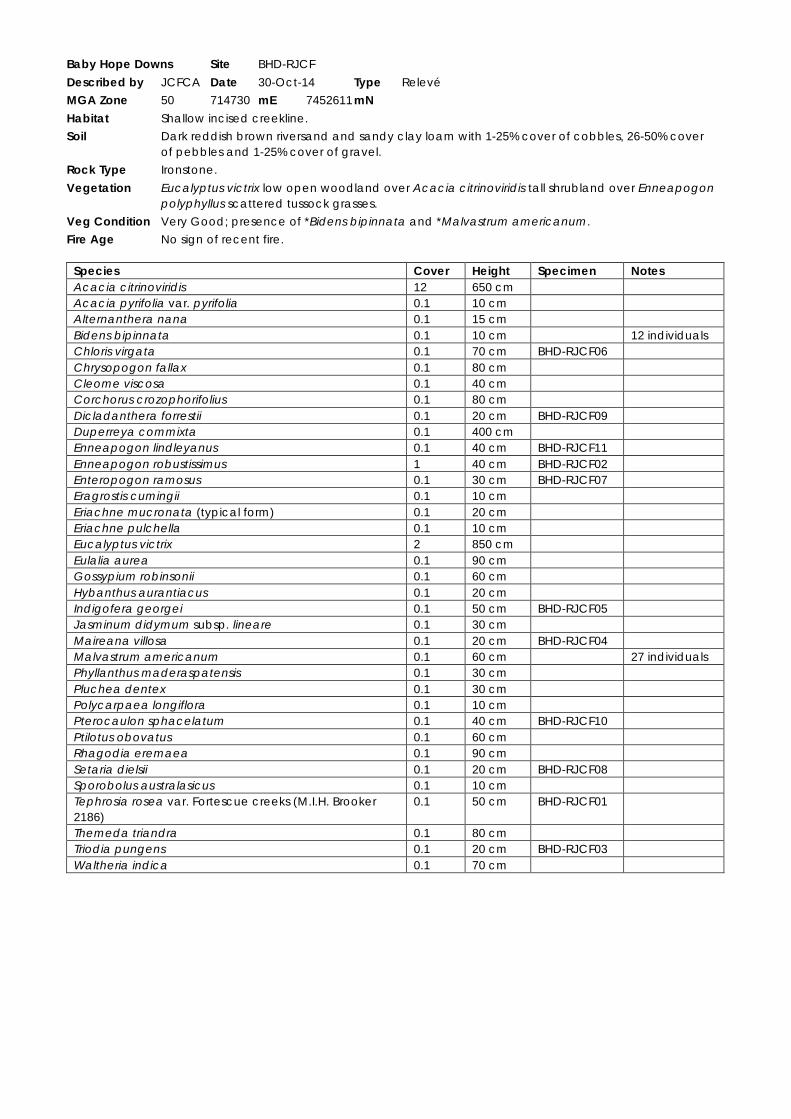
Baby Hope Downs Site BHD-RJCF
Described by JCFCA Date 30-Oct-14 Type Relevé
MGA Zone 50 714730 mE 7452611 mN
Habitat Shallow incised creekline.
Soil Dark reddish brown riversand and sandy clay loam with 1-25% cover of cobbles, 26-50% cover of pebbles and 1-25% cover of gravel.
Rock Type Ironstone.
Vegetation Eucalyptus victrix low open woodland over Acacia citrinoviridis tall shrubland over Enneapogon polyphyllus scattered tussock grasses.
Veg Condition Very Good; presence of *Bidens bipinnata and *Malvastrum americanum.
Fire Age No sign of recent fire.
Species Cover Height Specimen Notes Acacia citrinoviridis 12 650 cm Acacia pyrifolia var. pyrifolia 0.1 10 cm Alternanthera nana 0.1 15 cm Bidens bipinnata 0.1 10 cm 12 individuals Chloris virgata 0.1 70 cm BHD-RJCF06 Chrysopogon fallax 0.1 80 cm Cleome viscosa 0.1 40 cm Corchorus crozophorifolius 0.1 80 cm Dicladanthera forrestii 0.1 20 cm BHD-RJCF09 Duperreya commixta 0.1 400 cm Enneapogon lindleyanus 0.1 40 cm BHD-RJCF11 Enneapogon robustissimus 1 40 cm BHD-RJCF02 Enteropogon ramosus 0.1 30 cm BHD-RJCF07 Eragrostis cumingii 0.1 10 cm Eriachne mucronata (typical form) 0.1 20 cm Eriachne pulchella 0.1 10 cm Eucalyptus victrix 2 850 cm Eulalia aurea 0.1 90 cm Gossypium robinsonii 0.1 60 cm Hybanthus aurantiacus 0.1 20 cm Indigofera georgei 0.1 50 cm BHD-RJCF05 Jasminum didymum subsp. lineare 0.1 30 cm Maireana villosa 0.1 20 cm BHD-RJCF04 Malvastrum americanum 0.1 60 cm 27 individuals Phyllanthus maderaspatensis 0.1 30 cm Pluchea dentex 0.1 30 cm Polycarpaea longiflora 0.1 10 cm Pterocaulon sphacelatum 0.1 40 cm BHD-RJCF10 Ptilotus obovatus 0.1 60 cm Rhagodia eremaea 0.1 90 cm Setaria dielsii 0.1 20 cm BHD-RJCF08 Sporobolus australasicus 0.1 10 cm Tephrosia rosea var. Fortescue creeks (M.I.H. Brooker 2186)
0.1 50 cm BHD-RJCF01
Themeda triandra 0.1 80 cm Triodia pungens 0.1 20 cm BHD-RJCF03 Waltheria indica 0.1 70 cm

Baby Hope Downs Site BHD-RPCA
Described by PACEF Date 27-Oct-14 Type Relevé
MGA Zone 50 710776 mE 7453778 mN
Habitat Meandering gorge through a range of hills.
Soil Dark reddish brown; skeletal.
Rock Type Ironstone.
Vegetation Corymbia ferriticola (Eucalyptus leucophloia subsp. leucophloia) low open woodland over Astrotricha hamptonii tall open shrubland over Themeda triandra, Cymbopogon ? procerus very open tussock grassland with Triodia pungens scattered tussock grasses.
Veg Condition Very Good; Presence of *Bidens bipinnata.
Fire Age No sign of recent fire.
Species Cover Height Specimen Notes Abutilon sp. Dioicum (A.A. Mitchell PRP 1618) 0.1 130 cm BHD-RPCA02 Abutilon aff. sp. Dioicum (A.A. Mitchell PRP 1618) 0.1 60 cm BHD-RPCA08 Atypical. Determined
by M. Trudgen. Acacia aptaneura 0.1 250 cm Acacia bivenosa (wispy/weeping form) 0.1 300 cm BHD-RPCA09 Acacia hamersleyensis 0.1 280 cm Acacia pyrifolia var. pyrifolia 0.1 150 cm Aristida burbidgeae 0.1 40 cm BHD-RPCA01 Astrotricha hamptonii 2 250 cm Bidens bipinnata 0.1 15 cm 1 individual at
northern end Capparis lasiantha 0.1 100 cm Capparis spinosa var. nummularia 0.1 100 cm Cleome viscosa 0.1 40 cm Clerodendrum floribundum var. angustifolium 0.1 80 cm Corchorus lasiocarpus subsp. lasiocarpus 0.1 60 cm Corymbia ferriticola 5 600 cm Cucumis variabilis 0.1 60 cm Cymbopogon ? procerus 2 80 cm Cymbopogon ambiguus 0.1 80 cm Cynanchum floribundum 0.1 20 cm BHD-RPCA07 Cyperus cunninghamii subsp. cunninghamii 0.1 30 cm Dodonaea viscosa subsp. mucronata 0.1 150 cm BHD-PC05= Duperreya commixta 0.1 200 cm Enneapogon lindleyanus 0.1 50 cm Enneapogon polyphyllus 0.1 25 cm Eremophila longifolia 0.1 200 cm Eremophila tietkensii 0.1 100 cm Eriachne mucronata (typical form) 0.1 40 cm Eucalyptus leucophloia subsp. leucophloia 1 400 cm Eucalyptus xerothermica 0.1 500 cm Euphorbia trigonosperma 0.1 30 cm BHD-RPCA03 Gomphrena cunninghamii 0.1 10 cm Gossypium robinsonii 0.1 250 cm Hibiscus sp. Mt Robinson (G. Byrne 3537) 0.1 120 cm BHD-RPCA06 Indigofera sp. Fractiflexa (S. van Leeuwen 3773) 0.1 30 cm Jasminum didymum subsp. lineare 0.1 100 cm Lobelia heterophylla subsp. pilbarensis 0.1 30 cm Newcastelia sp. Hamersley Range (S. van Leeuwen 4264)
0.1 110 cm
Petalostylis labicheoides 0.1 350 cm Pterocaulon sphacelatum 0.1 15 cm BHD-RPCA05 Ptilotus obovatus 0.1 120 cm Rhagodia eremaea 0.1 45 cm Rhodanthe margarethae 0.1 90 cm Rhynchosia minima 0.1 20 cm Senna venusta 0.1 110 cm Sida sp. Shovelanna Hill (S. van Leeuwen 3842) 0.1 20 cm

Species Cover Height Specimen Notes Solanum gabrielae 0.1 30 cm BHD-RPCA04 Stemodia grossa 0.1 80 cm Stylobasium spathulatum 0.1 180 cm Themeda triandra 2 70 cm Tinospora smilacina 0.1 200 cm Trichodesma zeylanicum var. zeylanicum 0.1 80 cm Triodia longiceps 0.1 80 cm BHD-RPCA10 Triodia pungens 1 60 cm Triumfetta leptacantha 0.1 30 cm Tylophora flexuosa 0.1 10 cm

Baby Hope Downs Site BHD-RPCB
Described by PACEF Date 28-Oct-14 Type Relevé
MGA Zone 50 715209 mE 7454596 mN
Habitat Convergence of two steep rocky gullies.
Soil Dark reddish brown; skeletal.
Rock Type Ironstone.
Vegetation Eucalyptus leucophloia subsp. leucophloia (Corymbia hamersleyana) low woodland over Acacia hamersleyensis, Dodonaea viscosa subsp. mucronata tall shrubland over Cymbopogon ambiguus, Themeda triandra very open tussock grassland with Triodia pungens very open hummock grassland.
Veg Condition Excellent.
Fire Age No sign of recent fire.
Species Cover Height Specimen Notes Acacia bivenosa 0.1 350 cm Acacia hamersleyensis 8 300 cm Acacia monticola 0.1 220 cm Acacia pyrifolia var. pyrifolia 0.1 150 cm Acacia rhodophloia 0.1 150 cm Acacia spondylophylla 0.1 100 cm Anthobolus leptomerioides 0.1 110 cm Capparis lasiantha 0.1 130 cm Cassytha capillaris 0.1 100 cm Corymbia ferriticola 0.1 200 cm Corymbia hamersleyana 2 350 cm Cymbopogon ambiguus 1 90 cm BHD-PC16= Dodonaea viscosa subsp. mucronata 2 220 cm BHD-PC05= Duperreya commixta 0.1 250 cm Eremophila jucunda subsp. pulcherrima 0.1 120 cm Eremophila magnifica subsp. magnifica 0.1 170 cm 9 individuals Eremophila magnifica subsp. velutina 0.1 150 cm 8 individuals Eriachne mucronata (typical form) 0.1 35 cm Eucalyptus leucophloia subsp. leucophloia 16 550 cm Gossypium robinsonii 0.1 280 cm Grevillea wickhamii 0.1 320 cm Indigofera sp. Fractiflexa (S. van Leeuwen 3773) 0.1 70 cm Jasminum didymum subsp. lineare 0.1 110 cm Petalostylis labicheoides 0.1 400 cm Prostanthera albiflora 0.1 140 cm Psydrax suaveolens 0.1 120 cm Ptilotus obovatus 0.1 60 cm Santalum lanceolatum 0.1 300 cm Senna glutinosa subsp. glutinosa 0.1 200 cm Sida sp. Pilbara (A.A. Mitchell PRP 1543) 0.1 60 cm Sida sp. Shovelanna Hill (S. van Leeuwen 3842) 0.1 50 cm Solanum lasiophyllum 0.1 40 cm Themeda triandra 2 80 cm Triodia pungens 3 60 cm BHD-RPCB01 Triumfetta maconochieana 0.1 30 cm


Baby Hope Downs Site BHD-RPCC
Described by PACEF Date 29-Oct-14 Type Relevé
MGA Zone 50 711543 mE 7453647 mN
Habitat Rocky gorge running north-south between range of hills.
Soil Dark reddish brown; skeletal.
Rock Type Ironstone.
Vegetation Corymbia ferriticola (Eucalyptus leucophloia subsp. leucophloia, Acacia aptaneura) low woodland over Dodonaea viscosa subsp. mucronata, Astrotricha hamptonii tall open shrubland over Aristida burbidgeae, Eriachne mucronata, Cymbopogon ? procerus very open tussock grassland with Triodia longiceps, T. pungens very open hummock grassland.
Veg Condition Very Good; presence of *Bidens bipinnata and *Sigesbeckia orientalis.
Fire Age No sign of recent fire.
Notes Gorge opens up in the northern end into a rocky gully.
Species Cover Height Specimen Notes Acacia aptaneura x aneura 2 200 cm BHD-RPCC05 Acacia hamersleyensis 0.1 450 cm Acacia monticola 0.1 350 cm Acacia pyrifolia var. pyrifolia 0.1 220 cm Aristida burbidgeae 2 50 cm Astrotricha hamptonii 1 350 cm Bidens bipinnata 0.1 40 cm 2 individuals Capparis lasiantha 0.1 100 cm Capparis spinosa var. nummularia 0.1 20 cm Cheilanthes sieberi subsp. pseudovellea 0.1 25 cm BHD-RPCC06 Clerodendrum floribundum var. angustifolium 0.1 270 cm Corymbia ferriticola 12 900 cm Cucumis variabilis 0.1 20 cm Cymbopogon ? procerus 2 90 cm Cynanchum floribundum 0.1 30 cm Cyperus cunninghamii subsp. cunninghamii 0.1 30 cm Dodonaea viscosa subsp. mucronata 4 300 cm BHD-PC05= Duperreya commixta 0.1 60 cm Enchylaena tomentosa var. tomentosa 0.1 70 cm Eremophila jucunda subsp. pulcherrima 0.1 120 cm Eremophila longifolia 0.1 100 cm Eremophila sp. Hamersley Range (K. Walker KW 136) 0.1 210 cm BHD-RPCC07 7 adults. Eremophila tietkensii 0.1 180 cm Eriachne mucronata (typical form) 1 40 cm Eucalyptus leucophloia subsp. leucophloia 2 900 cm Eucalyptus victrix 0.1 700 cm Eucalyptus xerothermica 0.1 600 cm Euphorbia trigonosperma 0.1 25 cm BHD-RPCC01 Ficus brachypoda 0.1 300 cm Glycine canescens 0.1 30 cm Gossypium robinsonii 0.1 300 cm Hibiscus sp. Mt Robinson (G. Byrne 3537) 0.1 120 cm BHD-RPCC02 Hibiscus sp. Mt Robinson (G. Byrne 3537) 0.1 90 cm BHD-RPCC08 Indigofera sp. Fractiflexa (S. van Leeuwen 3773) 0.1 20 cm Jasminum didymum subsp. lineare 0.1 50 cm Petalostylis labicheoides 0.1 400 cm Polycarpaea longiflora 0.1 20 cm Prostanthera albiflora 0.1 120 cm Psydrax latifolia 0.1 350 cm Pterocaulon sphacelatum 0.1 40 cm BHD-RPCC03 Ptilotus obovatus 0.1 50 cm BHD-PC24= Rhodanthe margarethae 0.1 20 cm Senna glutinosa subsp. glutinosa 0.1 30 cm Sida sp. Shovelanna Hill (S. van Leeuwen 3842) 0.1 15 cm Sigesbeckia orientalis 0.1 60 cm 6 dead plants Solanum gabrielae 0.1 20 cm BHD-RPCC04

Species Cover Height Specimen Notes Solanum horridum 0.1 30 cm BHD-RPCC09 Solanum lasiophyllum 0.1 60 cm Triodia longiceps 3 90 cm Triodia pungens 2 50 cm

Baby Hope Downs Site BHD-RPCD
Described by PACEF Date 30-Oct-14 Type Relevé
MGA Zone 50 713491 mE 7453848 mN
Habitat Gorge dissecting a range of hills.
Soil Dark reddish brown; skeletal.
Rock Type Ironstone.
Vegetation Corymbia ferriticola, Acacia aptaneura low woodland over Acacia hamersleyensis, Dodonaea viscosa subsp. mucronata, Eremophila tietkensii tall open shrubland over Themeda triandra, Cymbopogon ambiguus very open tussock grassland with Triodia pungens scattered hummock grasses.
Veg Condition Excellent.
Fire Age No sign of recent fire.
Species Cover Height Specimen Notes Acacia aptaneura 2 700 cm Acacia bivenosa 0.1 300 cm Acacia hamersleyensis 2 600 cm Acacia pyrifolia var. pyrifolia 0.1 250 cm Aristida burbidgeae 0.1 40 cm Astrotricha hamptonii 0.1 250 cm Capparis lasiantha 0.1 170 cm Clerodendrum floribundum var. angustifolium
0.1 240 cm
Corymbia ferriticola 12 650 cm Cymbopogon ambiguus 1 130 cm BHD-PC16= Dodonaea viscosa subsp. mucronata 1 250 cm BHD-PC05= Duperreya commixta 0.1 400 cm Eremophila forrestii subsp. forrestii 0.1 150 cm Eremophila jucunda subsp. pulcherrima 0.1 150 cm Eremophila longifolia 0.1 150 cm Eremophila sp. Hamersley Range (K. Walker KW 136)
0.1 230 cm BHD-RPCD02 2 individuals; determination confirmed by A. Perkins (WAH)
Eremophila tietkensii 1 240 cm Eriachne mucronata (typical form) 0.1 45 cm Eucalyptus leucophloia subsp. leucophloia
0.1 650 cm
Euphorbia trigonosperma 0.1 10 cm BHD-RPCD03 Ficus brachypoda 0.1 250 cm Hibiscus sp. Gurinbiddy Range (M.E. Trudgen MET 15708)
0.1 140 cm BHD-RPCD05 30 individuals
Jasminum didymum subsp. lineare 0.1 250 cm Psydrax latifolia 0.1 140 cm Ptilotus obovatus 0.1 40 cm Santalum lanceolatum 0.1 250 cm Sida sp. Shovelanna Hill (S. van Leeuwen 3842)
0.1 30 cm
Solanum horridum 0.1 20 cm BHD-RPCD04 Solanum lasiophyllum 0.1 40 cm Themeda triandra 4 100 cm Triodia pungens 1 40 cm BHD-RPCD01
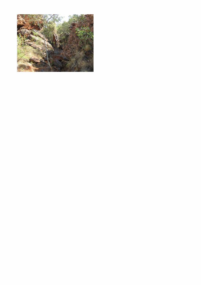

Baby Hope Downs Site BHD-RPCE
Described by PACEF Date 30-Oct-14 Type Relevé
MGA Zone 50 713559 mE 7453360 mN
Habitat Undulating floodplain between low hills on plain.
Soil Dark reddish brown sandy clay loam with 26-50% cover of cobbles, 1-25% cover of pebbles and 1-25% cover of gravel.
Rock Type Ironstone.
Vegetation Eucalyptus gamophylla low open woodland over Acacia inaequilatera tall open shrubland over Themeda triandra scattered tussock grasses with Triodia pungens (T. sp. Shovelanna Hill (S. van Leeuwen 3835)) open hummock grassland.
Veg Condition Excellent.
Fire Age No sign of recent fire.
Notes Dissected by ~30m drill lines and drill pads.
Species Cover Height Specimen Notes Acacia bivenosa 0.1 220 cm Acacia elachantha 0.1 220 cm BHD-PC32= Acacia inaequilatera 4 300 cm Acacia pruinocarpa 0.1 130 cm Acacia sibirica 0.1 180 cm BHD-RPCE01 Determined by M.
Trudgen as “crowded smaller phyllodes form”
Acacia tenuissima 0.1 220 cm Aristida contorta 0.1 30 cm Aristida holathera var. holathera 0.1 30 cm Corymbia deserticola subsp. deserticola 0.1 500 cm Cymbopogon ambiguus 0.1 90 cm Dodonaea viscosa subsp. mucronata 0.1 150 cm BHD-PC05= Duperreya commixta 0.1 60 cm Eragrostis setifolia 0.1 30 cm BHD-RPCE03 Eremophila forrestii subsp. forrestii 0.1 160 cm Eremophila fraseri subsp. fraseri 0.1 60 cm Eremophila longifolia 0.1 160 cm Eriachne mucronata (typical form) 0.1 40 cm Eucalyptus gamophylla 2 400 cm Eucalyptus leucophloia subsp. leucophloia 0.1 600 cm Eulalia aurea 0.1 90 cm Glycine canescens 0.1 60 cm Goodenia microptera 0.1 25 cm Goodenia stobbsiana 0.1 10 cm Gossypium robinsonii 0.1 350 cm Grevillea wickhamii 0.1 160 cm Hakea chordophylla 0.1 200 cm Ptilotus obovatus 0.1 70 cm Ptilotus rotundifolius 0.1 70 cm Rhagodia eremaea 0.1 120 cm Santalum lanceolatum 0.1 300 cm Senna artemisioides subsp. helmsii 0.1 100 cm Senna artemisioides subsp. oligophylla 0.1 45 cm BHD-RPCE02 Senna glutinosa subsp. x luerssenii 0.1 110 cm Solanum lasiophyllum 0.1 60 cm Stylobasium spathulatum 0.1 220 cm Themeda triandra 2 80 cm Triodia pungens 15 70 cm Triodia sp. Shovelanna Hill (S. van Leeuwen 3835)
1 30 cm


Baby Hope Downs Site BHD-RPCF
Described by PACEF Date 31-Oct-14 Type Relevé
MGA Zone 50 710602 mE 7452994 mN
Habitat Minor flow line and floodbank between low hills.
Soil Dark reddish brown with 26-50% cover of cobbles, 26-50% cover of pebbles and 26-50% cover of gravel.
Rock Type Ironstone.
Vegetation Eucalyptus xerothermica low open woodland over Petalostylis labicheoides, Acacia pyrifolia var. pyrifolia tall open shrubland over Eremophila longifolia scattered shrubs over Themeda triandra scattered tussock grasses with Triodia longiceps, T. pungens very open hummock grassland.
Veg Condition Very Good; evidence of cattle.
Fire Age No sign of recent fire.
Species Cover Height Specimen Acacia bivenosa 0.1 140 cm Acacia maitlandii 0.1 130 cm Acacia pruinocarpa 0.1 60 cm Acacia pyrifolia var. pyrifolia 2 240 cm Androcalva luteiflora 0.1 240 cm Cleome viscosa 0.1 20 cm Corymbia hamersleyana 0.1 400 cm Cucumis variabilis 0.1 150 cm Cullen leucochaites 0.1 220 cm Cymbopogon ambiguus 0.1 120 cm Cymbopogon procerus 0.1 140 cm Dodonaea viscosa subsp. mucronata 0.1 160 cm BHD-PC05= Duperreya commixta 0.1 30 cm Enneapogon caerulescens 0.1 15 cm Enneapogon lindleyanus 0.1 35 cm Enneapogon robustissimus 0.1 60 cm Eremophila longifolia 1 170 cm Eucalyptus gamophylla 0.1 220 cm Eucalyptus xerothermica 3 450 cm Gossypium robinsonii 0.1 240 cm Indigofera georgei 0.1 40 cm Jasminum didymum subsp. lineare 0.1 200 cm Melhania oblongifolia 0.1 30 cm Petalostylis labicheoides 6 300 cm Pterocaulon sphacelatum 0.1 50 cm BHD-RPCF01 Ptilotus astrolasius 0.1 60 cm Ptilotus nobilis subsp. nobilis 0.1 45 cm Ptilotus obovatus 0.1 130 cm Rhagodia eremaea 0.1 100 cm Rhynchosia minima 0.1 20 cm Santalum lanceolatum 0.1 130 cm Sida sp. spiciform panicles (E. Leyland s.n. 14/8/90) 0.1 110 cm Sporobolus australasicus 0.1 15 cm Streptoglossa decurrens 0.1 20 cm Stylobasium spathulatum 0.1 140 cm Tephrosia rosea var. Fortescue creeks (M.I.H. Brooker 2186) 0.1 45 cm Themeda triandra 1 120 cm Triodia longiceps 3 50 cm Triodia pungens 2 40 cm

Baby Hope Downs Site BHD-RPCG
Described by PACEF Date 29-Oct-14 Type Relevé
MGA Zone 50 712498 mE 7453596 mN
Habitat Minor flow line and floodplain between low rocky hills.
Soil Dark reddish brown with 51-75% cover of cobbles, 26-50% cover of pebbles and 26-50% cover of gravel.
Rock Type Ironstone.
Vegetation Eucalyptus xerothermica low open woodland over Themeda triandra, Cymbopogon ambiguus very open tussock grassland with Triodia longiceps, T. pungens open hummock grassland.
Veg Condition Very Good; presence of *Bidens bipinnata.
Fire Age No sign of recent fire.
Species Cover Height Specimen Notes Acacia bivenosa 0.1 200 cm Acacia hamersleyensis 0.1 250 cm Acacia pyrifolia var. pyrifolia 0.1 120 cm Bidens bipinnata 0.1 30 cm 2 individuals Capparis spinosa var. nummularia 0.1 35 cm Corymbia hamersleyana 0.1 500 cm Cucumis variabilis 0.1 120 cm Cymbopogon ambiguus 1 95 cm Dodonaea viscosa subsp. mucronata 0.1 230 cm BHD-PC05= Duperreya commixta 0.1 35 cm Enneapogon lindleyanus 0.1 120 cm Enneapogon polyphyllus 0.1 20 cm Eriachne mucronata (typical form) 0.1 40 cm Eucalyptus gamophylla 0.1 450 cm Eucalyptus leucophloia subsp. leucophloia 0.1 400 cm Eucalyptus xerothermica 3 550 cm Gomphrena cunninghamii 0.1 15 cm Goodenia stobbsiana 0.1 20 cm Gossypium robinsonii 0.1 240 cm Hakea chordophylla 0.1 300 cm Jasminum didymum subsp. lineare 0.1 70 cm Polycarpaea longiflora 0.1 20 cm Ptilotus obovatus 0.1 130 cm Rhagodia eremaea 0.1 100 cm Rhynchosia minima 0.1 30 cm Santalum lanceolatum 0.1 300 cm Senna glutinosa subsp. glutinosa 0.1 160 cm Stylobasium spathulatum 0.1 250 cm Themeda triandra 2 100 cm Triodia longiceps 15 90 cm Triodia pungens 4 70 cm Triodia wiseana 0.1 40 cm


Baby Hope Downs Flora and Vegetation Survey
Cube:Current:1049 (Baby Hope Downs Biological):Documents:Flora:Baby Hope Downs Flora Report_v10.docx
Appendix 11
Raw Data from Southern Flank to Jinidi (Biota 2012) Quadrats and Relevés in
the Current Study Area


Baby Hope Downs Site SFJ11
Described by PL/RM Date 26-Mar-11 Type Quadrat 50m x 50m
MGA Zone 50 713822 mE 7452457 mN
Habitat Wide drainage in valley.
Soil Light brown silty clay.
Rock Type Ironstone.
Vegetation Acacia citrinoviridis tall open shrubland over Sida sp. spiciform panicles (E. Leyland s.n. 14/8/90) scattered low shrubs over Triodia longiceps very open hummock grassland.
Veg Condition Very Good. Presence of *Bidens bipinnata, *Datura leichhardtii and *Malvastrum americanum.
Fire Age Burnt 3-5 years ago.
Species Cover Height Specimen Notes Abutilon fraseri subsp. fraseri 0.1 30 cm SFJ11-25 Acacia aptaneura 0.1 170 cm SFJ11-62 Acacia citrinoviridis 4 700 cm SFJ11-01 Acacia maitlandii 0.1 130 cm Acacia pruinocarpa 0.1 400 cm Acacia pyrifolia var. pyrifolia 0.1 230 cm Acrachne racemosa 0.1 30 cm SFJ11-44 Alternanthera nana 0.1 30 cm SFJ11-28 Amaranthus cuspidifolius 0.1 40 cm SFJ11-56 Androcalva luteiflora 0.1 150 cm Aristida contorta 0.1 40 cm Bidens bipinnata 0.1 30 cm Boerhavia aff. burbidgeana 0.1 10 cm SFJ11-23 Determined by M. Trudgen;
insufficient material for further determination.
Boerhavia coccinea 0.1 30 cm SFJ11-10 Bothriochloa ewartiana 0.1 50 cm SFJ11-22 Bulbostylis barbata 0.1 10 cm Bulbostylis turbinata 0.1 10 cm SFJ11-26 Centipeda minima subsp. macrocephala 0.1 4 cm SFJ11-55 Cheilanthes sieberi subsp. sieberi 0.1 15 cm SFJ11-84 Chrysopogon fallax 0.1 130 cm Cleome viscosa 0.1 40 cm Commelina ensifolia 0.1 40 cm PL36= Convolvulus clementii 0.1 20 cm SFJ11-06 Corchorus crozophorifolius 0.1 100 cm SFJ11-30 Corchorus tridens 0.1 10 cm Cucumis variabilis 0.1 100 cm Cyperus bulbosus 0.1 30 cm SFJ11-57 Cyperus iria 0.1 10 cm SFJ11-32 Dactyloctenium radulans 0.1 10 cm Datura leichhardtii 0.1 40 cm SFJ11-58 Dicladanthera forrestii 0.1 10 cm SFJ11-51 Digitaria ctenantha 0.1 10 cm SFJ11-14 Dipteracanthus australasicus subsp. australasicus 0.1 40 cm SFJ11-49 Duperreya commixta 0.1 30 cm Dysphania sp. 0.1 10 cm SFJ11-45 Seedling; insufficient material
for further determination. Enchylaena tomentosa var. tomentosa 0.1 1 cm SFJ11-36 Enneapogon caerulescens 0.1 30 cm SFJ11-43 Enneapogon polyphyllus 0.1 50 cm SFJ11-05 Enneapogon robustissimus 0.1 50 cm SFJ11-24 Eragrostis cumingii 0.1 10 cm SFJ09-24= Eragrostis leptocarpa 0.1 40 cm SFJ11-83 Eremophila longifolia 0.1 100 cm Eriachne mucronata 0.1 40 cm SFJ11-12 Eriachne pulchella 0.1 10 cm SFJ11-04 Eriachne tenuiculmis 0.1 90 cm SFJ11-53 Eulalia aurea 0.1 80 cm SFJ11-91 Euphorbia australis var. subtomentosa 0.1 10 cm SFJ11-50 Determined by S. Dillon (WAH). Euphorbia biconvexa 0.1 40 cm SFJ11-64 Euphorbia tannensis subsp. eremophila 0.1 10 cm SFJ11-33 Evolvulus alsinoides var. villosicalyx 0.1 10 cm Glycine canescens 0.1 30 cm SFJ11-15 Goodenia microptera 0.1 5 cm SFJ11-79 Goodenia prostrata 0.1 2 cm SFJ11-41

Species Cover Height Specimen Notes Goodenia stellata 0.1 2 cm SFJ11-86 Haloragis sp. 0.1 5 cm SFJ11-31 Seedling; insufficient material
for further determination. Heliotropium cunninghamii 0.1 20 cm SFJ11-66 Hybanthus aurantiacus 0.1 30 cm Indigofera georgei 0.1 40 cm SFJ11-07 Ipomoea polymorpha 0.1 10 cm SFJ11-60 Iseilema membranaceum 0.1 40 cm SFJ11-18 Isotropis forrestii 0.1 40 cm SFJ11-20 Jasminum didymum subsp. lineare 0.1 100 cm SFJ11-34 Maireana villosa 0.1 40 cm SFJ11-03 Malvastrum americanum 0.1 25 cm NI= 50 Melhania oblongifolia 0.1 40 cm SFJ11-40 Nicotiana sp. 0.1 20 cm SFJ11-85 Insufficient material for further
determination. Notoleptopus decaisnei 0.1 30 cm Paraneurachne muelleri 0.1 30 cm Paspalidium basicladum 0.1 30 cm SFJ11-35 Peplidium ? muelleri 0.1 1 cm SFJ11-82a Perotis rara 0.1 10 cm Phyllanthus maderaspatensis 0.1 40 cm SFJ11-65 Polycarpaea corymbosa var. corymbosa 0.1 7 cm Polycarpaea longiflora 0.1 30 cm Portulaca oleracea/intraterranea 0.1 20 cm Pterocaulon sphaeranthoides 0.1 1 cm SFJ11-08 Ptilotus astrolasius 0.1 40 cm Ptilotus helipteroides 0.1 2 cm Ptilotus nobilis subsp. nobilis 0.1 5 cm Ptilotus obovatus 0.1 60 cm Rhagodia eremaea 0.1 100 cm Sclerolaena cornishiana 0.1 20 cm Senna artemisioides subsp. x artemisioides 0.1 140 cm SFJ11-88 Senna glutinosa subsp. glutinosa 0.1 140 cm Senna notabilis 0.1 20 cm Setaria dielsii 0.1 60 cm SFJ11-46 Sida ectogama 0.1 100 cm SFJ11-63 Sida fibulifera 0.1 30 cm SFJ11-21 Sida sp. 0.1 5 cm SFJ11-16 Determined by M. Trudgen;
insufficient material for further determination.
Sida sp. spiciform panicles (E. Leyland s.n. 14/8/90) 1 100 cm SFJ11-38 Solanum lasiophyllum 0.1 50 cm SFJ11-89 Solanum sp. 0.1 6 cm SFJ11-52 Determined by M. Trudgen;
insufficient material for further determination.
Sporobolus australasicus 0.1 10 cm Stylobasium spathulatum 0.1 220 cm Synaptantha tillaeacea var. tillaeacea 0.1 5 cm SFJ11-19 Tephrosia rosea var. Fortescue creeks (M.I.H. Brooker 2186)
0.1 10 cm SFJ11-11
Themeda triandra 0.1 100 cm SFJ11-90 Tragus australianus 0.1 10 cm SFJ11-09 Tribulus astrocarpus 0.1 2 cm SFJ11-42 Trichodesma zeylanicum var. zeylanicum 0.1 30 cm Triodia longiceps 5 40 cm SFJ11-02 Triodia pungens 0.1 30 cm SFJ11-47 Urochloa occidentalis var. ciliata 0.1 30 cm SFJ11-77 Urochloa subquadripara 0.1 40 cm SFJ11-61

Baby Hope Downs Site SFJ12
Described by ER/SC Date 26-Mar-11 Type Q 50m x 50m
MGA Zone 50 715420 mE 7452909 mN
Habitat Mulga floodplain; gently sloping towards the north at < 5 degrees.
Soil Red-brown sandy silt.
Rock Type Ironstone.
Vegetation Acacia aptaneura (A. pruinocarpa) low open forest over Maireana villosa scattered low shrubs over *Bidens bipinnata, Portulaca oleracea/intraterranea scattered herbs.
Veg Condition Very Good. Evidence of cattle, presence of *Bidens bipinnata and *Chloris virgata.
Fire Age Burnt 3-5 years ago.
Species Cover Height Specimen Notes Abutilon fraseri subsp. fraseri 0.1 20 cm SFJ12-30 Acacia aptaneura 30 800 cm SFJ12-21 Acacia pruinocarpa 2 700 cm Alternanthera nana 0.1 15 cm SFJ12-14 Amaranthus cuspidifolius 0.1 50 cm SFJ12-15 Aristida ingrata 0.1 150 cm SFJ12-23 Bidens bipinnata 2 40 cm NI= 3 Boerhavia coccinea 0.1 5 cm SFJ12-06 Bothriochloa ewartiana 0.1 60 cm SFJ12-12 Calandrinia sp. 0.1 5 cm SFJ12-16 Chloris virgata 0.1 50 cm SFJ12-10 Determined by S. Dillon
(WAH). Chrysopogon fallax 0.1 110 cm Cleome viscosa 0.1 15 cm Convolvulus clementii 0.1 2 cm SFJ12-25 Determined by S. Dillon
(WAH). Corchorus tridens 0.1 10 cm SFJ12-02 Cucumis variabilis 0.1 5 cm Dactyloctenium radulans 0.1 20 cm SFJ12-07 Dipteracanthus australasicus subsp. australasicus 0.1 20 cm SFJ12-32 Duperreya commixta 0.1 100 cm Dysphania sp. 0.1 7 cm SFJ12-05 Seedling; insufficient material
for further determination. Eremophila forrestii subsp. forrestii 0.1 120 cm Euphorbia sp. (biconvexa/coghlanii/trigonosperma; sterile)
0.1 2 cm SFJ12-20
Evolvulus alsinoides var. villosicalyx 0.1 5 cm SFJ12-13 Iseilema membranaceum 0.1 15 cm SFJ12-03 Jasminum didymum subsp. lineare 0.1 50 cm Maireana villosa 1 40 cm SFJ12-01 Paraneurachne muelleri 0.1 30 cm SFJ12-24 Perotis rara 0.1 10 cm SFJ12-08 Polycarpaea corymbosa var. corymbosa 0.1 10 cm SFJ16-01= Portulaca oleracea/intraterranea 1 2 cm Ptilotus nobilis subsp. nobilis 0.1 10 cm Juvenile. Ptilotus obovatus 0.1 40 cm Rhagodia eremaea 0.1 130 cm Salsola australis 0.1 20 cm SFJ12-22 Senna artemisioides subsp. oligophylla x subsp. helmsii 0.1 140 cm SFJ12-34 Senna notabilis 0.1 5 cm SFJ12-26 Sida sp. verrucose glands (F.H. Mollemans 2423) 0.1 40 cm SFJ12-27 Sporobolus australasicus 0.1 10 cm SFJ12-04 Themeda triandra 0.1 130 cm SFJ12-31 Tragus australianus 0.1 20 cm SFJ12-17 Tribulus astrocarpus 0.1 2 cm SFJ12-09

Baby Hope Downs Site SFJ13
Described by PL/RM Date 26-Mar-11 Type Quadrat 50m x 50m
MGA Zone 50 709101 mE 7452857 mN
Habitat Gently south sloping foothill.
Soil Dark brown clay loam; fine iron powder on surface with ironstone rocks.
Rock Type Ironstone.
Vegetation Eucalyptus gamophylla scattered low mallees over Acacia inaequilatera tall open shrubland over Amphipogon sericeus, Digitaria brownii scattered tussock grasses with Triodia sp. Shovelanna Hill (S. van Leeuwen 3835) very open hummock grassland.
Veg Condition Excellent.
Fire Age Burnt 3-5 years ago.
Species Cover Height Specimen Notes Acacia aptaneura 0.1 100 cm SFJ13-06 Acacia cowleana 0.1 100 cm SFJ13-08 Acacia inaequilatera 2 300 cm Amphipogon sericeus 1 30 cm SFJ13-12 Androcalva luteiflora 0.1 160 cm Aristida holathera var. holathera 0.1 40 cm SFJ13-23 Aristida inaequiglumis 0.1 100 cm SFJ13-11 Cleome viscosa 0.1 70 cm SFJ07-26= Codonocarpus cotinifolius 0.1 4 cm SFJ13-25 Codonocarpus cotinifolius 0.1 100 cm Corchorus sp. 0.1 10 cm SFJ13-27 Insufficient material for further
determination. Cucumis variabilis 0.1 50 cm Cymbopogon obtectus 0.1 100 cm SFJ13-09 Dampiera candicans 0.1 40 cm Digitaria brownii 1 50 cm SFJ13-03 Duperreya commixta 0.1 120 cm Dysphania sp. 0.1 5 cm SFJ13-13 Seedling; insufficient material
for further determination. Enneapogon polyphyllus 0.1 40 cm SFJ11-05= Eragrostis setifolia 0.1 40 cm SFJ13-07 Eremophila longifolia 0.1 130 cm Eriachne mucronata 0.1 50 cm SFJ13-24 Eucalyptus gamophylla 1 350 cm Euphorbia australis 0.1 2 cm SFJ13-16 Determined by S. Dillon (WAH). Fimbristylis simulans 0.1 10 cm SFJ13-17 Goodenia microptera 0.1 10 cm SFJ13-20 Goodenia microptera 0.1 10 cm SFJ13-26 Goodenia stobbsiana 0.1 10 cm Goodenia triodiophila 0.1 40 cm SFJ13-15 Hakea chordophylla 0.1 200 cm Hibiscus coatesii 0.1 40 cm SFJ13-22 Hibiscus sturtii var. campylochlamys 0.1 40 cm SFJ07-02= Indigofera monophylla 0.1 40 cm SFJ13-14 Keraudrenia velutina subsp. elliptica 0.1 50 cm SFJ13-04 Oldenlandia crouchiana 0.1 3 cm Paraneurachne muelleri 0.1 40 cm Perotis rara 0.1 10 cm Polycarpaea holtzei 0.1 2 cm SFJ13-18 Portulaca oleracea/intraterranea 0.1 1 cm NI= 20. Ptilotus astrolasius 0.1 40 cm Ptilotus axillaris 0.1 20 cm Ptilotus calostachyus 0.1 50 cm Ptilotus helipteroides 0.1 30 cm Ptilotus obovatus var. obovatus 0.1 30 cm Rhagodia eremaea 0.1 60 cm Rhyncharrhena linearis 0.1 130 cm Scaevola parvifolia subsp. pilbarae 0.1 30 cm SFJ13-05 Senna artemisioides subsp. oligophylla x subsp. helmsii 0.1 80 cm SFJ13-10 Senna notabilis 0.1 20 cm Sida sp. verrucose glands (F.H. Mollemans 2423) 0.1 40 cm SFJ13-21 Solanum lasiophyllum 0.1 40 cm Sporobolus australasicus 0.1 10 cm Triodia pungens 0.1 50 cm SFJ13-02 Triodia sp. Shovelanna Hill (S. van Leeuwen 3835) 6 30 cm SFJ13-01

Baby Hope Downs Site SFJ14
Described by ER/SC Date 26-Mar-11 Type Quadrat 50m x 50m
Location Approximately 56 km south west of Marillana Homestead, 79 km north west of Newman and 134 km east of Tom Price
MGA Zone 50 709995 mE 7453316 mN
Habitat East facing hill crest.
Soil Skeletal gravel and outcropping ironstone.
Rock Type Ironstone.
Vegetation Eucalyptus leucophloia subsp. leucophloia, Corymbia hamersleyana low open woodland over Dampiera candicans scattered low shrubs over Triodia sp. Shovelanna Hill (S. van Leeuwen 3835), T. wiseana (T. pungens) open hummock grassland.
Veg Condition Excellent; historical tracks.
Fire Age No sign of recent fire.
Species Cover Height Specimen Notes Acacia adsurgens 0.1 130 cm SFJ14-22 Acacia hamersleyensis 0.1 50 cm SFJ14-25 Juvenile. Acacia hilliana 0.1 20 cm SFJ14-19 Acacia maitlandii 0.1 50 cm SFJ14-18 Acacia pyrifolia var. pyrifolia 0.1 250 cm Aristida burbidgeae 0.1 40 cm SFJ14-06 Bulbostylis barbata 0.1 10 cm SFJ14-20 Corchorus lasiocarpus subsp. lasiocarpus 0.1 50 cm SFJ14-14 Corymbia hamersleyana 1 500 cm SFJ14-04 Cymbopogon obtectus 0.1 130 cm SFJ14-17 Cymbopogon procerus 0.1 50 cm SFJ14-05 Dampiera candicans 1 25 cm Duperreya commixta 0.1 100 cm Dysphania sp. 0.1 10 cm SFJ14-08 Seedling; insufficient material for
further determination. Eragrostis desertorum 0.1 45 cm SFJ14-24 Eriachne mucronata 0.1 30 cm SFJ= Eriachne pulchella 0.1 10 cm SFJ14-10 Eucalyptus leucophloia subsp. leucophloia 2 850 cm SFJ14-03 Goodenia stobbsiana 0.1 20 cm Hakea chordophylla 0.1 350 cm SFJ14-16 Jasminum didymum subsp. lineare 0.1 100 cm Maireana villosa 0.1 20 cm SFJ12-01= Paspalidium clementii 0.1 10 cm SFJ14-09 Peripleura virgata 0.1 15 cm SFJ14-07 Perotis rara 0.1 10 cm SFJ12-08= Petalostylis labicheoides 0.1 250 cm Polycarpaea longiflora 0.1 5 cm SFJ07-08= Ptilotus astrolasius 0.1 40 cm Ptilotus calostachyus 0.1 150 cm Ptilotus helipteroides 0.1 10 cm SFJ14-13 Ptilotus obovatus var. obovatus 0.1 20 cm SFJ02-18= Rhagodia eremaea 0.1 50 cm Scaevola browniana subsp. browniana 0.1 25 cm SFJ14-23 Senna glutinosa subsp. glutinosa 0.1 210 cm Sida sp. Excedentifolia (J.L. Egan 1925) 0.1 25 cm SFJ14-21 Sida sp. Excedentifolia (J.L. Egan 1925) 0.1 50 cm SFJ14-12 Sida sp. Pilbara (A.A. Mitchell PRP 1543) 0.1 25 cm SFJ14-15 Determined by M. Trudgen as Sida
aff. pilbarensis (EOB46-01B). Solanum lasiophyllum 0.1 30 cm Sporobolus australasicus 0.1 40 cm SFJ12-04= Tragus australianus 0.1 15 cm SFJ12-17= Triodia pungens 1 60 cm SFJ14-11 Triodia sp. Shovelanna Hill (S. van Leeuwen 3835) 15 60 cm SFJ14-02 Triodia wiseana 10 80 cm SFJ14-01

Baby Hope Downs Site SFJ15
Described by PL/BM Date 27-Mar-11 Type Quadrat 50m x 50m
MGA Zone 50 712758 mE 7453176 mN
Habitat West sloping hill crest.
Soil Brown silty loam. Continuous surface layer of pebbles and rocks.
Rock Type Ironstone.
Vegetation Corymbia deserticola subsp. deserticola scattered low trees over Acacia inaequilatera scattered tall shrubs over Triodia sp. Shovelanna Hill (S. van Leeuwen 3835) open hummock grassland.
Veg Condition Very Good. Presence of *Bidens bipinnata.
Fire Age Burnt 3-5 years ago.
Species Cover Height Specimen Notes Acacia bivenosa 0.1 100 cm Acacia inaequilatera 2 250 cm Amphipogon sericeus 0.1 20 cm SFJ13-12= Aristida holathera var. holathera 0.1 30 cm SFJ13-23= Bidens bipinnata 0.1 10 cm Cleome viscosa 0.1 10 cm Clerodendrum floribundum var. angustifolium 0.1 10 cm SFJ15-08 Corymbia deserticola subsp. deserticola 1 350 cm Cucumis variabilis 0.1 10 cm Cymbopogon obtectus 0.1 80 cm SFJ13-09= Dampiera candicans 0.1 40 cm SFJ15-09 Dysphania sp. 0.1 8 cm SFJ11-45= Seedling; insufficient material for
further determination. Enneapogon polyphyllus 0.1 8 cm Fimbristylis dichotoma 0.1 20 cm SFJ15-01 Fimbristylis simulans 0.1 10 cm SFJ13-17= Goodenia microptera 0.1 2 cm SFJ15-03 Goodenia muelleriana 0.1 2 cm SFJ15-06 Goodenia stobbsiana 0.1 10 cm Goodenia triodiophila 0.1 30 cm SFJ13-15= Indigofera monophylla 0.1 30 cm Jasminum didymum subsp. lineare 0.1 180 cm Oldenlandia crouchiana 0.1 1 cm Paraneurachne muelleri 0.1 40 cm Paspalidium clementii 0.1 20 cm SFJ15-05 Peripleura virgata 0.1 10 cm SFJ15-07 Polygala glaucifolia 0.1 6 cm Ptilotus astrolasius 0.1 40 cm Ptilotus calostachyus 0.1 7 cm Ptilotus nobilis subsp. nobilis 0.1 6 cm Ptilotus obovatus var. obovatus 0.1 30 cm Ptilotus rotundifolius 0.1 80 cm Senna artemisioides subsp. oligophylla 0.1 50 cm SFJ15-02 Senna glaucifolia x 0.1 100 cm SFJ15-04 Senna glutinosa subsp. glutinosa 0.1 160 cm Senna glutinosa subsp. pruinosa 0.1 150 cm Solanum lasiophyllum 0.1 20 cm Sporobolus australasicus 0.1 10 cm Themeda triandra 0.1 80 cm SFJ11-90= Trachymene oleracea subsp. oleracea 0.1 6 cm Trichodesma zeylanicum var. zeylanicum 0.1 30 cm Triodia pungens 0.1 30 cm SFJ13-02= Triodia sp. Shovelanna Hill (S. van Leeuwen 3835)
25 30 cm SFJ13-01=

Baby Hope Downs Site SFJ16
Described by ER/SC Date 27-Mar-11 Type Quadrat 50m x 50m
MGA Zone 50 706957 mE 7452510 mN
Habitat Flat Mulga floodplain.
Soil Red-brown silt with patchy surface cover of rocks and pebbles.
Rock Type Not recorded.
Vegetation Acacia aptaneura (Eucalyptus xerothermica) low open forest over Ptilotus obovatus, Maireana villosa scattered low shrubs over *Bidens bipinnata, Cleome viscosa very open herbland over Chrysopogon fallax scattered tussock grasses.
Veg Condition Very Good. Evidence of cattle and presence of *Bidens bipinnata, *Malvastrum americanum.
Fire Age Burnt 3-5 years ago.
Species Cover Height Specimen Notes Abutilon macrum 0.1 10 cm SFJ16-14 Acacia aptaneura 30 900 cm SFJ16-26 Acacia pruinocarpa 0.1 10 cm Seedling. Aristida contorta 0.1 40 cm SFJ16-02 Bidens bipinnata 2 20 cm SFJ16-05 Boerhavia coccinea 0.1 5 cm SFJ16-10 Bulbostylis barbata 0.1 5 cm SFJ16-19 Cheilanthes sieberi subsp. sieberi 0.1 10 cm SFJ16-08 Chrysopogon fallax 2 160 cm SFJ04-04= Cleome viscosa 1 15 cm Commelina ensifolia 0.1 5 cm SFJ16-22 Corchorus tridens 0.1 5 cm SFJ12-02= Cucumis variabilis 0.1 20 cm Dactyloctenium radulans 0.1 20 cm SFJ12-07= Dipteracanthus australasicus subsp. australasicus 0.1 20 cm SFJ12-32= Dipteracanthus australasicus subsp. australasicus 0.1 15 cm SFJ16-12 Duperreya commixta 0.1 40 cm Dysphania sp. 0.1 2 cm SFJ12-05= Seedling; insufficient material
for further determination. Eremophila forrestii subsp. forrestii 0.1 150 cm SFJ16-06 Eremophila lanceolata 0.1 30 cm SFJ16-13 Eriachne pulchella 0.1 5 cm SFJ16-04 Eucalyptus xerothermica 1 450 cm SFJ16-27 Euphorbia sp. (biconvexa/coghlanii/trigonosperma; sterile)
0.1 2 cm SFJ12-20=
Euphorbia tannensis subsp. eremophila 0.1 20 cm SFJ16-23 Evolvulus alsinoides var. villosicalyx 0.1 30 cm SFJ12-13= Goodenia stellata 0.1 5 cm SFJ16-17 Ipomoea polymorpha 0.1 15 cm SFJ16-25 Iseilema membranaceum 0.1 20 cm SFJ16-09 Maireana planifolia x villosa 0.1 20 cm SFJ16-11 Maireana villosa 1 40 cm SFJ12-01= Malvastrum americanum 0.1 20 cm SFJ16-15 Melhania oblongifolia 0.1 40 cm SFJ16-28 Paspalidium clementii 0.1 5 cm SFJ16-03 Perotis rara 0.1 5 cm SFJ12-08= Polycarpaea corymbosa var. corymbosa 0.1 10 cm SFJ16-01 Portulaca oleracea/intraterranea 0.1 1 cm Pterocaulon sphaeranthoides 0.1 15 cm SFJ16-18 Ptilotus helipteroides 0.1 20 cm SFJ14-13= Ptilotus nobilis subsp. nobilis 0.1 5 cm Juvenile. Ptilotus obovatus var. obovatus 1 50 cm SFJ16-07 Rhagodia eremaea 0.1 150 cm Salsola australis 0.1 30 cm SFJ12-22= Solanum lasiophyllum 0.1 100 cm Sporobolus australasicus 0.1 10 cm SFJ12-04 Tragus australianus 0.1 15 cm SFJ12-17= Trichodesma zeylanicum var. zeylanicum 0.1 15 cm SFJ16-16

Baby Hope Downs Site SFJ28
Described by ER/RM Date 30-Mar-11 Type Quadrat 50m x 50m
MGA Zone 50 715991 mE 7454042 mN
Habitat Moderate southeast hill slope at approximately 10 degrees.
Soil Skeletal red-brown clay loam. Surface layer of pebbles and rocks.
Rock Type Not recorded.
Vegetation Eucalyptus leucophloia subsp. leucophloia, Acacia pruinocarpa low open woodland over Grevillea wickhamii, Hakea chordophylla scattered tall shrubs over Acacia spondylophylla low open shrubland over Triodia wiseana, T. sp. Shovelanna Hill (S. van Leeuwen 3835) hummock grassland.
Veg Condition Excellent; historical tracks.
Fire Age No sign of recent fire.
Species Cover Height Specimen Notes Acacia hilliana 0.1 45 cm SFJ28-09 Acacia inaequilatera 0.1 200 cm Acacia pruinocarpa 1 250 cm Acacia spondylophylla 7 60 cm SFJ28-03 Brunonia australis 0.1 5 cm SFJ30-08 Bulbostylis barbata 0.1 15 cm SFJ28-07 Bulbostylis barbata 0.1 5 cm Duperreya commixta 0.1 100 cm Enneapogon polyphyllus 0.1 50 cm SFJ28-05 Eriachne pulchella 0.1 10 cm SFJ28-04 Eucalyptus leucophloia subsp. leucophloia 3 600 cm Goodenia triodiophila 0.1 40 cm SFJ21-20= Grevillea wickhamii 1 300 cm Sterile; insufficient material to
determine subspecies. Hakea chordophylla 1 300 cm Indigofera monophylla 0.1 10 cm SFJ28-06 Mitrasacme connata 0.1 5 cm SFJ28-13 Polycarpaea holtzei 0.1 5 cm SFJ28-08 Polygala glaucifolia 0.1 5 cm SFJ22-09= Schizachyrium fragile 0.1 30 cm SFJ28-12 Senna glaucifolia 0.1 150 cm SFJ28-14 Senna glutinosa subsp. glutinosa 0.1 120 cm Senna glutinosa subsp. x luerssenii 0.1 160 cm SFJ28-11 Solanum lasiophyllum 0.1 20 cm Stackhousia sp. 0.1 10 cm SFJ28-15 Juvenile. Streptoglossa decurrens 0.1 5 cm SFJ28-10 Trachymene oleracea subsp. oleracea 0.1 5 cm Triodia sp. Shovelanna Hill (S. van Leeuwen 3835) 35 60 cm SFJ28-02 Triodia wiseana 35 70 cm SFJ28-01

Baby Hope Downs Site SFJ38
Described by CFMH Date 27-Aug-11 Type Quadrat 50m x 50m
Location Approximately 58 km south west of Marillana Homestead, 81 km north west of Newman and 132 km east of Tom Price
MGA Zone 50 708019 mE 7452545 mN
Habitat Flat, rocky floodplain next to creekline.
Soil Dark reddish brown alluvial clay with stones.
Rock Type Ironstone.
Vegetation Petalostylis labicheoides, Acacia pyrifolia var. pyrifolia tall shrubland over Ptilotus obovatus scattered low shrubs over Eriachne tenuiculmis scattered tussock grasses with Triodia longiceps open hummock grassland.
Veg Condition Very Good. Presence of *Malvastrum americanum.
Fire Age No sign of recent fire.
Species Cover Height Specimen Notes Acacia maitlandii 0.1 60 cm SFJ38-16 Acacia pruinocarpa 0.1 220 cm Acacia pyrifolia var. pyrifolia 7 220 cm SFJ38-12 Acrachne racemosa 0.1 10 cm SFJ38-10 Androcalva luteiflora 0.1 310 cm Aristida contorta 0.1 15 cm Boerhavia sp. 0.1 1 cm Dead; insufficient material for
further determination. Bothriochloa ewartiana 0.1 80 cm SFJ38-02 Chrysopogon fallax 0.1 120 cm Cleome viscosa 0.1 120 cm Dead. Dicladanthera forrestii 0.1 30 cm SFJ38-46 Dipteracanthus australasicus subsp. australasicus 0.1 10 cm SFJ38-20 Duperreya commixta 0.1 15 cm Dysphania rhadinostachya subsp. rhadinostachya 0.1 15 cm SFJ38-11 Enneapogon caerulescens 0.1 10 cm SFJ38-05 Enneapogon polyphyllus 0.1 15 cm SFJ38-04 Enneapogon robustissimus 0.1 80 cm SFJ38-03 Eriachne pulchella 0.1 5 cm SFJ38-26 Eriachne tenuiculmis 1 40 cm SFJ38-15 Eucalyptus xerothermica 0.1 900 cm Euphorbia australis var. subtomentosa 0.1 1 cm SFJ38-29 Determined by S. Dillon (WAH). Euphorbia australis var. subtomentosa 0.1 1 cm SFJ38-18 Determined by S. Dillon (WAH). Euphorbia biconvexa 0.1 20 cm SFJ38-41 Determined by S. Dillon (WAH). Euphorbia tannensis subsp. eremophila 0.1 15 cm SFJ38-01 Determined by S. Dillon (WAH). Evolvulus alsinoides var. villosicalyx 0.1 20 cm Goodenia microptera 0.1 10 cm SFJ38-44 Goodenia muelleriana 0.1 10 cm SFJ38-30 Goodenia muelleriana 0.1 15 cm SFJ38-38 Goodenia stellata 0.1 4 cm SFJ38-42 Hakea lorea subsp. lorea 0.1 260 cm Haloragis gossei 0.1 4 cm Sterile; insufficient material for
determination to variety. Heliotropium cunninghamii 0.1 2 cm SFJ38-40 Hibiscus sturtii var. aff. grandiflorus 0.1 20 cm SFJ38-17 Hybanthus aurantiacus 0.1 20 cm Indigofera georgei 0.1 50 cm SFJ38-07 Iseilema vaginiflorum 0.1 15 cm SFJ38-25 Isotropis forrestii 0.1 25 cm SFJ38-43 Jasminum didymum subsp. lineare 0.1 120 cm Leiocarpa semicalva subsp. semicalva 0.1 35 cm SFJ38-21 Lepidium phlebopetalum 0.1 5 cm SFJ38-35 Malvastrum americanum 0.1 15 cm Paraneurachne muelleri 0.1 30 cm Paspalidium clementii 0.1 5 cm SFJ38-13 Petalostylis labicheoides 10 350 cm Phyllanthus maderaspatensis 0.1 30 cm SFJ38-33 Polycarpaea longiflora 0.1 8 cm Polymeria ambigua 0.1 10 cm SFJ38-23 Pterocaulon sphaeranthoides 0.1 10 cm SFJ38-19 Ptilotus aervoides 0.1 5 cm SFJ38-39 Ptilotus astrolasius 0.1 20 cm

Species Cover Height Specimen Notes Ptilotus helipteroides 0.1 15 cm Ptilotus nobilis subsp. nobilis 0.1 8 cm Ptilotus obovatus var. obovatus 1 70 cm Rhagodia eremaea 0.1 40 cm Salsola australis 0.1 25 cm SFJ38-31 Scaevola amblyanthera var. centralis 0.1 3 cm SFJ38-22 Senna artemisioides subsp. x artemisioides 0.1 110 cm SFJ38-45 Setaria dielsii 0.1 80 cm SFJ38-08 Sida fibulifera 0.1 20 cm SFJ38-34 Sida sp. spiciform panicles (E. Leyland s.n. 14/8/90) 0.1 120 cm SFJ38-28 Sida sp. verrucose glands (F.H. Mollemans 2423) 0.1 20 cm SFJ38-47 Solanum lasiophyllum 0.1 40 cm SFJ38-27 Sporobolus australasicus 0.1 20 cm Stylobasium spathulatum 0.1 80 cm Tephrosia rosea var. Fortescue creeks (M.I.H. Brooker 2186)
0.1 20 cm SFJ38-32
Tephrosia rosea var. Fortescue creeks (M.I.H. Brooker 2186)
0.1 3 cm SFJ38-24
Themeda triandra 0.1 110 cm Trichodesma zeylanicum var. zeylanicum 0.1 20 cm Triodia longiceps 20 70 cm SFJ38-09 Triodia pungens 0.1 40 cm SFJ38-14 Triodia wiseana 0.1 50 cm SFJ38-37 Triraphis mollis 0.1 50 cm SFJ38-06 Zygophyllum eichleri 0.1 2 cm SFJ38-36 Determined by S. Dillon (WAH).

Baby Hope Downs Site SFJ40
Described by ERMHM Date 27-Aug-11 Type Quadrat 50m x 50m
Location Approximately 57 km south west of Marillana Homestead, 79 km north west of Newman and 135 km east of Tom Price
MGA Zone 50 710251 mE 7452543 mN
Habitat Stony plain, very gently sloping to the south towards major drainage.
Soil Dark reddish brown silty clay with surface rocks and pebbles.
Rock Type Ironstone.
Vegetation Eucalyptus gamophylla scattered low mallees over Triodia pungens very open hummock grassland.
Veg Condition Very good. Evidence of cattle, presence of *Cenchrus ciliaris (>1%).
Fire Age No sign of recent fire.
Species Cover Height Specimen Notes Abutilon otocarpum 0.1 10 cm Acacia aptaneura 0.1 700 cm SFJ40-43 Acacia aptaneura 0.1 250 cm SFJ40-36 Acacia bivenosa 0.1 5 cm Acacia pachyacra 0.1 200 cm SFJ40-37 Acacia pruinocarpa 0.1 180 cm Acacia tenuissima 0.1 300 cm SFJ40-25 Alternanthera nana 0.1 25 cm SFJ40-18 Amphipogon sericeus 0.1 40 cm SFJ43-01= Androcalva luteiflora 0.1 300 cm Anthobolus leptomerioides 0.1 100 cm SFJ61-xx= Aristida contorta 0.1 15 cm Boerhavia coccinea 0.1 10 cm SFJ40-38 Cenchrus ciliaris 0.1 40 cm Chrysocephalum apiculatum 0.1 20 cm SFJ40-24 Chrysopogon fallax 0.1 120 cm Cleome viscosa 0.1 35 cm Codonocarpus cotinifolius 0.1 350 cm Cucumis variabilis 0.1 50 cm Cymbopogon ambiguus 0.1 120 cm SFJ40-16 Digitaria brownii 0.1 60 cm SFJ40-31 Dipteracanthus australasicus subsp. australasicus 0.1 15 cm SFJ40-12 Duperreya commixta 0.1 50 cm Dysphania kalpari 0.1 10 cm Dysphania rhadinostachya subsp. rhadinostachya 0.1 10 cm SFJ40-09 Enchylaena tomentosa var. tomentosa 0.1 70 cm SFJ40-33 Enneapogon caerulescens 0.1 20 cm SFJ40-45 Enneapogon lindleyanus 0.1 50 cm SFJ40-42 Enneapogon lindleyanus 0.1 20 cm SFJ40-14 Enneapogon polyphyllus 0.1 60 cm SFJ40-19 Eremophila longifolia 0.1 180 cm Eriachne mucronata 0.1 50 cm SFJ40-13 Eriachne pulchella 0.1 7 cm SFJ40-08 Eucalyptus gamophylla 2 350 cm Eucalyptus leucophloia subsp. leucophloia 0.1 350 cm Eucalyptus xerothermica 0.1 200 cm Euphorbia australis 0.1 2 cm SFJ40-29 Determined by S. Dillon (WAH). Euphorbia australis var. hispidula 0.1 2 cm SFJ40-05 Determined by S. Dillon (WAH). Euphorbia biconvexa 0.1 15 cm SFJ40-28 Determined by S. Dillon (WAH). Euphorbia tannensis subsp. eremophila 0.1 200 cm SFJ40-39 Determined by S. Dillon (WAH). Evolvulus alsinoides var. villosicalyx 0.1 10 cm Goodenia microptera 0.1 15 cm SFJ40-26 Hibiscus burtonii 0.1 30 cm SFJ40-23 Hibiscus burtonii 0.1 50 cm SFJ40-44 Hibiscus sturtii var. platychlamys 0.1 60 cm SFJ40-22 Maireana villosa 0.1 30 cm SFJ40-06 Melhania oblongifolia 0.1 20 cm SFJ40-32 Notoleptopus decaisnei 0.1 10 cm Variety not determined. Paraneurachne muelleri 0.1 50 cm Paspalidium clementii 0.1 15 cm SFJ40-04 Paspalidium clementii 0.1 10 cm SFJ40-40 Phyllanthus erwinii 0.1 5 cm SFJ40-10 Polycarpaea corymbosa var. corymbosa 0.1 10 cm

Species Cover Height Specimen Notes Portulaca oleracea/intraterranea 0.1 3 cm SFJ40-07 Psydrax suaveolens 0.1 160 cm SFJ40-35 Pterocaulon sphaeranthoides 0.1 5 cm SFJ40-17 Ptilotus calostachyus 0.1 50 cm Ptilotus helipteroides 0.1 5 cm Ptilotus nobilis subsp. nobilis 0.1 50 cm Ptilotus obovatus var. obovatus 0.1 30 cm Rhagodia eremaea 0.1 30 cm Salsola australis 0.1 10 cm SFJ40-27 Scaevola amblyanthera var. amblyanthera 0.1 30 cm SFJ40-20 Senna artemisioides subsp. helmsii 0.1 120 cm Senna artemisioides subsp. oligophylla x subsp. helmsii 0.1 150 cm SFJ40-11 Senna charlesiana 0.1 150 cm SFJ40-34 Senna glutinosa subsp. pruinosa 0.1 130 cm SFJ40-02 Senna notabilis 0.1 10 cm Sida echinocarpa 0.1 40 cm SFJ40-21 Sida sp. verrucose glands (F.H. Mollemans 2423) 0.1 25 cm SFJ40-41 Sida sp. verrucose glands (F.H. Mollemans 2423) 0.1 5 cm SFJ40-15 Sida sp. verrucose glands (F.H. Mollemans 2423) 0.1 40 cm SFJ40-03 Solanum lasiophyllum 0.1 40 cm Sporobolus australasicus 0.1 10 cm Themeda triandra 0.1 60 cm Trichodesma zeylanicum var. zeylanicum 0.1 20 cm Triodia pungens 4 40 cm SFJ40-01

Baby Hope Downs Site SFJ41
Described by CFCA Date 27-Aug-11 Type Quadrat 50m x 50m
Location Approximately 56 km south west of Marillana Homestead, 78 km north west of Newman and 135 km east of Tom Price
MGA Zone 50 710864 mE 7453083 mN
Habitat Crest and slope of low rolling hills.
Soil Dark reddish brown clay loam with continuous lag gravel of pebbles to rocks.
Rock Type Not recorded.
Vegetation Amphipogon sericeus scattered tussock grasses with Triodia sp. Shovelanna Hill (S. van Leeuwen 3835) open hummock grassland.
Veg Condition Excellent.
Fire Age Burnt 3-5 years ago.
Species Cover Height Specimen Notes Acacia adoxa var. adoxa 0.1 25 cm Acacia inaequilatera 0.1 350 cm SFJ41-16 Amphipogon sericeus 1 45 cm SFJ41-02 Aristida holathera var. holathera 0.1 15 cm Brunonia australis 0.1 30 cm SFJ41-06 NI= 2 Codonocarpus cotinifolius 0.1 25 cm Corymbia deserticola subsp. deserticola 0.1 430 cm Resprouting. Cymbopogon obtectus 0.1 25 cm SFJ41-21 Dysphania rhadinostachya subsp. rhadinostachya 0.1 20 cm SFJ41-03 Eriachne lanata 0.1 45 cm SFJ41-15 Eriachne mucronata (arid form) (MET 12 736) 0.1 35 cm SFJ41-19 Eriachne pulchella 0.1 5 cm Eucalyptus leucophloia subsp. leucophloia 0.1 510 cm Fimbristylis simulans 0.1 15 cm SFJ41-07 Gompholobium oreophilum 0.1 55 cm SFJ41-17 Gompholobium oreophilum 0.1 40 cm SFJ41-12 Goodenia microptera 0.1 20 cm SFJ41-08a Goodenia stobbsiana 0.1 10 cm SFJ41-04 Goodenia triodiophila 0.1 30 cm Hakea chordophylla 0.1 420 cm Hibiscus sturtii var. campylochlamys 0.1 20 cm SFJ41-18 Indigofera monophylla 0.1 25 cm SFJ41-08b Jasminum didymum subsp. lineare 0.1 150 cm Panicum effusum 0.1 20 cm SFJ41-13 Paraneurachne muelleri 0.1 50 cm Paspalidium clementii 0.1 15 cm SFJ41-11 Polycarpaea corymbosa var. corymbosa 0.1 10 cm Polygala glaucifolia 0.1 10 cm SFJ41-14 Ptilotus astrolasius 0.1 40 cm SFJ41-24 Ptilotus calostachyus 0.1 130 cm Ptilotus clementii 0.1 25 cm Ptilotus helipteroides 0.1 15 cm Ptilotus nobilis subsp. nobilis 0.1 15 cm Ptilotus obovatus var. obovatus 0.1 45 cm Rhagodia eremaea 0.1 130 cm SFJ41-10 Santalum lanceolatum 0.1 300 cm Schizachyrium fragile 0.1 15 cm SFJ41-05 Senna artemisioides subsp. oligophylla 0.1 50 cm SFJ41-09 Senna glutinosa subsp. glutinosa 0.1 70 cm Senna glutinosa subsp. pruinosa 0.1 75 cm Solanum lasiophyllum 0.1 40 cm SFJ41-12 Sporobolus australasicus 0.1 15 cm Tephrosia oxalidea 0.1 5 cm SFJ41-20 Triodia pungens 0.1 45 cm SFJ41-22 Triodia sp. Shovelanna Hill (S. van Leeuwen 3835) 25 35 cm SFJ41-01
Baby Hope Downs Site SFJ42
Described by JCFCA Date 27-Aug-11 Type Quadrat 50m x 50m
Location Southern Flank to Jinidi Proposed Rail loop.
MGA Zone 50 712006 mE 7452664 mN Habitat Open, flat floodplain.
Soil Dark reddish brown clay loam.
Rock Type Not recorded.
Vegetation Acacia aptaneura, A. citrinoviridis, A. pruinocarpa low open woodland over Triodia longiceps open hummock grassland.
Veg Condition Good. Moderately grazed by cattle and presence of *Acetosa vesicaria, *Bidens bipinnata, *Cenchrus setiger, *Malvastrum americanum and *Sigesbeckia orientalis.
Fire Age No sign of recent fire.
Species Cover Height Specimen Notes Abutilon otocarpum 0.1 30 cm SFJ42-05 Acacia aptaneura 2 400 cm SFJ42-26 Acacia citrinoviridis 2 400 cm Acacia pruinocarpa 1 280 cm Acacia pyrifolia var. pyrifolia 0.1 35 cm SFJ42-32 Juvenile. Acetosa vesicaria 0.1 60 cm NI= 6 Alternanthera nana 0.1 15 cm Amaranthus cuspidifolius 0.1 50 cm SFJ42-46 Aristida contorta 0.1 30 cm Bidens bipinnata 0.1 30 cm Boerhavia coccinea 0.1 10 cm SFJ42-15 Bulbostylis barbata 0.1 10 cm Cenchrus setiger 0.1 35 cm Centipeda minima subsp. macrocephala 0.1 5 cm Cheilanthes sieberi subsp. sieberi 0.1 35 cm SFJ42-30 Chrysocephalum apiculatum 0.1 20 cm SFJ42-24 Chrysocephalum gilesii 0.1 30 cm SFJ42-06 Chrysopogon fallax 0.1 110 cm Cleome viscosa 0.1 35 cm Cleome viscosa 0.1 25 cm Convolvulus angustissimus subsp. angustissimus 0.1 15 cm SFJ42-34 Convolvulus clementii 0.1 10 cm SFJ42-09 Determined by S. Dillon (WAH). Corchorus tridens 0.1 15 cm Cucumis variabilis 0.1 100 cm Dicladanthera forrestii 0.1 40 cm SFJ42-29 Dipteracanthus australasicus subsp. australasicus 0.1 25 cm SFJ42-28 Duperreya commixta 0.1 200 cm Dysphania kalpari 0.1 10 cm Dysphania kalpari 0.1 10 cm SFJ42-12 Enneapogon lindleyanus 0.1 35 cm SFJ42-48 Eragrostis cumingii 0.1 100 cm SFJ42-03 Eremophila forrestii subsp. forrestii 0.1 70 cm SFJ42-39 Eremophila longifolia 0.1 150 cm Euphorbia australis var. subtomentosa 0.1 5 cm SFJ42-31 Determined by S. Dillon (WAH). Euphorbia australis var. subtomentosa 0.1 5 cm SFJ42-36 Determined by S. Dillon (WAH). Euphorbia australis var. subtomentosa 0.1 5 cm SFJ42-19 Determined by S. Dillon (WAH). Euphorbia sp. 0.1 5 cm Euphorbia tannensis subsp.
eremophila/E. boophthona; insufficient material for collection.
Evolvulus alsinoides var. villosicalyx 0.1 15 cm Glycine canescens 0.1 15 cm SFJ42-08 Gomphrena cunninghamii 0.1 20 cm SFJ42-14 Goodenia microptera 0.1 5 cm SFJ42-20 Goodenia stellata 0.1 5 cm SFJ42-01 Heliotropium cunninghamii 0.1 20 cm SFJ42-11 Hibiscus sturtii var. aff. grandiflorus 0.1 20 cm SFJ42-18 Indigofera georgei 0.1 50 cm SFJ42-04 Iseilema membranaceum 0.1 5 cm SFJ42-17 Lepidium phlebopetalum 0.1 15 cm SFJ42-33 Maireana villosa 0.1 20 cm SFJ42-37 Maireana villosa 0.1 30 cm SFJ42-10 Malvastrum americanum 0.1 25 cm Paraneurachne muelleri 0.1 25 cm

Species Cover Height Specimen Notes Perotis rara 0.1 15 cm Petalostylis labicheoides 0.1 300 cm Podaxis pistillaris 0.1 10 cm Fungus. Polycarpaea corymbosa var. corymbosa 0.1 20 cm Polymeria ambigua 0.1 10 cm SFJ42-23 Portulaca oleracea/intraterranea 0.1 5 cm SFJ42-13 Pterocaulon sphaeranthoides 0.1 25 cm SFJ42-27 Pterocaulon sphaeranthoides 0.1 5 cm SFJ42-47 Ptilotus aervoides 0.1 5 cm SFJ42-35 Ptilotus helipteroides 0.1 15 cm Ptilotus nobilis subsp. nobilis 0.1 60 cm Ptilotus obovatus var. obovatus 0.1 70 cm Rhagodia eremaea 0.1 30 cm Salsola australis 0.1 10 cm Santalum lanceolatum 0.1 170 cm SFJ42-44 Scaevola amblyanthera var. amblyanthera 0.1 5 cm SFJ42-45 Scaevola amblyanthera var. centralis 0.1 25 cm SFJ42-07 Senna artemisioides subsp. oligophylla x subsp. helmsii 0.1 90 cm SFJ42-40 Senna glutinosa subsp. x luerssenii 0.1 120 cm Senna glutinosa subsp. x luerssenii 0.1 125 cm SFJ42-41 Sida fibulifera 0.1 20 cm SFJ42-22 Sigesbeckia orientalis 0.1 20 cm SFJ42-16 Sporobolus australasicus 0.1 10 cm Streptoglossa decurrens 0.1 15 cm SFJ42-42 Themeda triandra 0.1 100 cm Tribulus astrocarpus 0.1 5 cm Trichodesma zeylanicum var. zeylanicum 0.1 30 cm Triodia longiceps 20 125 cm SFJ42-25 Triodia pungens 0.1 60 cm SFJ42-38 Triraphis mollis 0.1 15 cm SFJ42-21 Wahlenbergia tumidifructa 0.1 15 cm SFJ42-02

Baby Hope Downs Site SFJ43
Described by ERMH Date 26-Aug-11 Type Quadrat 50m x 50m
Location Approximately 54 km south west of Marillana Homestead, 76 km north west of Newman and 137 km east of Tom Price
MGA Zone 50 713433 mE 7453268 mN
Habitat Rocky, flat, low hill crest; very gently sloping to the east and west.
Soil Dark reddish brown clay loam with continuous ironstone pebbles.
Rock Type Ironstone.
Vegetation Corymbia deserticola subsp. deserticola scattered low trees over Triodia sp. Shovelanna Hill (S. van Leeuwen 3835) open hummock grassland.
Veg Condition Excellent.
Fire Age No sign of recent fire.
Species Cover Height Specimen Notes Acacia cowleana 0.1 80 cm SFJ43-12 Acacia inaequilatera 0.1 240 cm Acacia inaequilatera 0.1 120 cm SFJ43-03 Acacia tenuissima 0.1 110 cm SFJ43-33 Acacia trudgeniana 0.1 110 cm SFJ43-23 Amphipogon sericeus 0.1 30 cm SFJ43-01 Amyema gibberula var. gibberula 0.1 50 cm SFJ43-31 Amyema sanguinea var. pulchra 0.1 50 cm SFJ43-32 Aristida contorta 0.1 8 cm Codonocarpus cotinifolius 0.1 310 cm Corymbia deserticola subsp. deserticola 1 430 cm SFJ43-18 Cymbopogon obtectus 0.1 130 cm SFJ43-16 Duperreya commixta 0.1 20 cm Dysphania rhadinostachya subsp. rhadinostachya 0.1 4 cm SFJ43-06 Enneapogon polyphyllus 0.1 10 cm SFJ43-27 Eremophila longifolia 0.1 130 cm Eriachne mucronata 0.1 10 cm Euphorbia australis var. australis 0.1 8 cm SFJ43-26 Determined by S. Dillon (WAH). Euphorbia boophthona 0.1 15 cm SFJ43-25 Fimbristylis simulans 0.1 8 cm SFJ43-05 Gompholobium oreophilum 0.1 40 cm SFJ43-28 Goodenia microptera 0.1 8 cm SFJ43-04 Goodenia stobbsiana 0.1 30 cm SFJ43-09 Goodenia triodiophila 0.1 20 cm SFJ43-15 Hakea chordophylla 0.1 320 cm Hibiscus coatesii 0.1 120 cm SFJ43-19 Indigofera monophylla 0.1 15 cm SFJ43-13 Oldenlandia crouchiana 0.1 1 cm Paraneurachne muelleri 0.1 20 cm Paspalidium clementii 0.1 15 cm SFJ43-20 Peripleura arida 0.1 6 cm SFJ43-24 Polycarpaea corymbosa var. corymbosa 0.1 5 cm Polycarpaea holtzei 0.1 2 cm Polygala glaucifolia 0.1 1 cm SFJ43-08 Ptilotus calostachyus 0.1 60 cm Ptilotus helipteroides 0.1 10 cm Ptilotus nobilis subsp. nobilis 0.1 40 cm Ptilotus obovatus var. obovatus 0.1 50 cm Ptilotus rotundifolius 0.1 40 cm Senna artemisioides subsp. helmsii 0.1 130 cm Senna glutinosa subsp. pruinosa 0.1 100 cm SFJ43-30 Senna glutinosa subsp. x luerssenii 0.1 110 cm SFJ43-17 Solanum lasiophyllum 0.1 20 cm Stackhousia intermedia 0.1 10 cm SFJ43-21 Determined by S. Dillon (WAH). Themeda triandra 0.1 110 cm Trachymene oleracea subsp. oleracea 0.1 20 cm SFJ43-22 Triodia pungens 0.1 35 cm SFJ43-10 Triodia sp. Shovelanna Hill (S. van Leeuwen 3835) 23 20 cm SFJ43-02

Baby Hope Downs Site SFJ45
Described by ERMHM Date 27-Aug-11 Type Quadrat 50m x 50m
Location Approximately 54 km south west of Marillana Homestead, 74 km north west of Newman and 139 km east of Tom Price
MGA Zone 50 715223 mE 7452374 mN
Habitat Undulating plain on the valley floor.
Soil Dark reddish brown silty clay with pisolitic gravel and rocks.
Rock Type Ironstone.
Vegetation Acacia pruinocarpa tall open shrubland over Chrysopogon fallax scattered tussock grasses with Triodia pungens (T. longiceps) hummock grassland.
Veg Condition Very good. Evidence of cattle and presence of *Bidens bipinnata.
Fire Age Very long unburnt.
Species Cover Height Specimen Notes Abutilon otocarpum 0.1 10 cm Abutilon otocarpum 0.1 15 cm SFJ46-26= Acacia aptaneura 0.1 230 cm SFJ45-23 Acacia citrinoviridis 0.1 300 cm Acacia pruinocarpa 2 350 cm Acacia pyrifolia var. pyrifolia 0.1 150 cm SFJ45-24 . Amphipogon sericeus 0.1 40 cm SFJ43-01= Aristida contorta 0.1 20 cm Bidens bipinnata 0.1 30 cm NI= 10 Boerhavia coccinea 0.1 10 cm SFJ45-15 Bulbostylis barbata 0.1 5 cm Chrysocephalum gilesii 0.1 15 cm SFJ45-20 Chrysopogon fallax 2 80 cm Cleome viscosa 0.1 25 cm Codonocarpus cotinifolius 0.1 200 cm Cucumis variabilis 0.1 30 cm Dactyloctenium radulans 0.1 10 cm Digitaria brownii 0.1 20 cm SFJ40-31= Dipteracanthus australasicus subsp. australasicus 0.1 30 cm SFJ40-12= Duperreya commixta 0.1 20 cm Dysphania kalpari 0.1 10 cm Dysphania rhadinostachya subsp. rhadinostachya 0.1 10 cm SFJ45-07 Enneapogon caerulescens 0.1 15 cm SFJ45-06 Enneapogon polyphyllus 0.1 40 cm SFJ45-12 Enneapogon robustissimus 0.1 70 cm SFJ45-17 Eragrostis eriopoda 0.1 50 cm SFJ45-11 Eremophila forrestii subsp. forrestii 0.1 50 cm SFJ45-26 Eriachne mucronata 0.1 50 cm SFJ40-13= Eriachne pulchella 0.1 10 cm SFJ45-05 Euphorbia australis var. subtomentosa 0.1 5 cm SFJ45-04 Determined by S. Dillon (WAH). Evolvulus alsinoides var. villosicalyx 0.1 15 cm Glycine canescens 0.1 60 cm SFJ45-18 Gossypium australe (Burrup Peninsula form) 0.1 70 cm Heliotropium inexplicitum 0.1 5 cm SFJ45-25 Hibiscus sturtii var. platychlamys 0.1 20 cm SFJ45-14 Hybanthus aurantiacus 0.1 30 cm Indigofera georgei 0.1 50 cm SFJ45-02 Maireana planifolia 0.1 90 cm SFJ45-28 Paraneurachne muelleri 0.1 20 cm Paspalidium clementii 0.1 10 cm SFJ45-21 Perotis rara 0.1 10 cm Phyllanthus erwinii 0.1 20 cm SFJ45-34 Phyllanthus erwinii 0.1 5 cm SFJ45-10 Polycarpaea corymbosa var. corymbosa 0.1 10 cm Polycarpaea longiflora 0.1 15 cm Portulaca oleracea/intraterranea 0.1 5 cm SFJ45-09 Determined by S. Dillon (WAH). Pterocaulon sphaeranthoides 0.1 25 cm SFJ45-08 Ptilotus helipteroides 0.1 15 cm Ptilotus nobilis subsp. nobilis 0.1 30 cm Ptilotus obovatus var. obovatus 0.1 60 cm Rhagodia eremaea 0.1 100 cm Salsola australis 0.1 30 cm SFJ45-31 Senna glutinosa subsp. glutinosa 0.1 100 cm SFJ45-27

Species Cover Height Specimen Notes Senna glutinosa subsp. x luerssenii 0.1 120 cm SFJ45-33 Senna notabilis 0.1 5 cm Sida echinocarpa 0.1 30 cm SFJ45-29 Sida echinocarpa 0.1 30 cm Sida fibulifera 0.1 50 cm SFJ45-02b Sida sp. spiciform panicles (E. Leyland s.n. 14/8/90) 0.1 60 cm SFJ45-16 Sporobolus australasicus 0.1 15 cm Streptoglossa decurrens 0.1 50 cm Synaptantha tillaeacea var. tillaeacea 0.1 5 cm SFJ45-03 Tephrosia sp. 0.1 10 cm SFJ45-13 Determined by M. Trudgen;
insufficient material for further determination.
Trichodesma zeylanicum var. zeylanicum 0.1 25 cm Triodia longiceps 2 80 cm SFJ45-32 Triodia pungens 40 40 cm SFJ45-01 Triraphis mollis 0.1 10 cm SFJ45-19

Baby Hope Downs Site SFJR12
Described by JFMHM Date 25-Aug-11 Type Quadrat 50m x 50m
Location Approximately 53 km south west of Marillana Homestead, 74 km north west of Newman and 139 km east of Tom Price
MGA Zone 50 715420 mE 7452909 mN
Habitat Mulga floodplain, gently sloping north at ~ 5 degrees.
Soil Dark reddish brown sandy silt with scattered cobbles on surface.
Rock Type Ironstone.
Vegetation Acacia aptaneura (A. pruinocarpa) low woodland.
Veg Condition Good. Evidence of cattle and presence of *Acetosa vesicaria, *Bidens bipinnata and *Malvastrum americanum.
Fire Age No sign of recent fire.
Species Cover Height Specimen Notes Abutilon fraseri subsp. fraseri 0.1 30 cm SFP212-21 Abutilon otocarpum 0.1 20 cm SFP212-15 Acacia adsurgens 0.1 80 cm SFP212-17 Acacia aptaneura 20 600 cm SFP212-51 Acacia pruinocarpa 1 600 cm Acetosa vesicaria 0.1 15 cm SFP212-29 Alternanthera nana 0.1 15 cm SFP212-05 Amaranthus cuspidifolius 0.1 80 cm SFP212-35 Aristida contorta 0.1 20 cm SFP212-26 Bidens bipinnata 0.1 15 cm NI= 100 Boerhavia coccinea 0.1 5 cm SFP212-02 Boerhavia repleta 0.1 5 cm SFP212-45 Bothriochloa ewartiana 0.1 80 cm SFP212-18 Calandrinia ptychosperma 0.1 5 cm SFP212-01 Calotis hispidula 0.1 5 cm SFP212-28 Centipeda minima subsp. macrocephala 0.1 10 cm SFP212-40 Chloris virgata 0.1 40 cm SFP212-38 Chrysopogon fallax 0.1 110 cm Cleome viscosa 0.1 25 cm Convolvulus clementii 0.1 20 cm SFP212-23 Determined by S. Dillon
(WAH). Corchorus tridens 0.1 10 cm Cucumis variabilis 0.1 50 cm Cymbopogon ambiguus 0.1 60 cm SFP212-27 Dactyloctenium radulans 0.1 5 cm Dichanthium sericeum subsp. humilius 0.1 25 cm SFP212-50 Digitaria ctenantha 0.1 15 cm SFP212-12 Dipteracanthus australasicus subsp. australasicus 0.1 15 cm SFP212-19 Duperreya commixta 0.1 100 cm Dysphania melanocarpa forma melanocarpa 0.1 10 cm SFP212-22 Dysphania rhadinostachya subsp. rhadinostachya 0.1 15 cm SFP2-50-03 Dysphania sphaerosperma 0.1 15 cm SFP2-25-25 Enneapogon polyphyllus 0.1 20 cm SFP212-43 Enneapogon polyphyllus 0.1 30 cm SFP212-09 Eremophila forrestii subsp. forrestii 0.1 100 cm Eriachne mucronata 0.1 60 cm SFP212-32 Eriachne pulchella 0.1 15 cm Euphorbia sp. (biconvexa/coghlanii/trigonosperma; sterile)
0.1 5 cm SFP212-44
Evolvulus alsinoides var. villosicalyx 0.1 20 cm Gnephosis arachnoidea 0.1 10 cm SFP212-42 Goodenia lyrata 0.1 5 cm SFP212-39 Determined by M. Trudgen. Goodenia microptera 0.1 25 cm SFP212-03 Hibiscus sturtii var. aff. grandiflorus 0.1 40 cm SFP212-25 Indigofera monophylla 0.1 30 cm SFP212-04 Determined as Indigofera
monophylla (brown calyx form) by M. Trudgen.
Iseilema membranaceum 0.1 5 cm SFP212-11 Jasminum didymum subsp. lineare 0.1 50 cm Lepidium phlebopetalum 0.1 5 cm SFP212-20 Maireana villosa 0.1 30 cm SFP212-08 Malvastrum americanum 0.1 30 cm NI= 100 Melhania oblongifolia 0.1 15 cm SFP212-30 Nicotiana occidentalis subsp. obliqua 0.1 30 cm SFP212-41

Species Cover Height Specimen Notes Paraneurachne muelleri 0.1 20 cm Paspalidium clementii 0.1 20 cm SFP212-49 Pluchea rubelliflora 0.1 25 cm SFP212-36 Podaxis pistillaris 0.1 12 cm Fungus. Polycarpaea corymbosa var. corymbosa 0.1 15 cm Portulaca oleracea/intraterranea 0.1 5 cm SFP212-13 Determined by S. Dillon
(WAH). Pterocaulon sphaeranthoides 0.1 30 cm Ptilotus nobilis subsp. nobilis 0.1 50 cm Ptilotus obovatus var. obovatus 0.1 40 cm Rhagodia eremaea 0.1 100 cm Salsola australis 0.1 15 cm SFP212-14 Senna artemisioides subsp. oligophylla (thinly sericeous form MET 15,035)
0.1 30 cm SFP212-16
Senna artemisioides subsp. oligophylla x subsp. helmsii 0.1 100 cm SFP212-33 Senna notabilis 0.1 20 cm Sida echinocarpa 0.1 10 cm SFP212-06 Sida sp. spiciform panicles (E. Leyland s.n. 14/8/90) 0.1 100 cm SFP212-24 Sida sp. verrucose glands (F.H. Mollemans 2423) 0.1 15 cm SFP212-10 Sporobolus australasicus 0.1 30 cm Streptoglossa decurrens 0.1 25 cm Themeda triandra 0.1 80 cm Trichodesma zeylanicum var. zeylanicum 0.1 25 cm Triodia longiceps 0.1 60 cm SFP212-31 Triodia pungens 0.1 60 cm SFP212-47 Wahlenbergia tumidifructa 0.1 25 cm SFP212-37

Baby Hope Downs Site SFJR13
Described by JFMHM Date 25-Aug-11 Type Quadrat 50m x 50m
Location Approximately 57 km south west of Marillana Homestead, 80 km north west of Newman and 133 km east of Tom Price
MGA Zone 50 709101 mE 7452857 mN
Habitat Base of hill.
Soil Dark reddish brown clay loam with scattered rocks.
Rock Type Ironstone.
Vegetation Eucalyptus gamophylla scattered low mallees over Acacia inaequilatera tall open shrubland over Amphipogon sericeus open tussock grassland and Triodia sp. Shovelanna Hill (S. van Leeuwen 3835) very open hummock grassland.
Veg Condition Excellent.
Fire Age Burnt 3-5 years ago.
Species Cover Height Specimen Notes Acacia aptaneura 0.1 100 cm SFP213-13 Acacia cowleana 0.1 110 cm SFP213-22 Acacia inaequilatera 2 100 cm SFP213-32 Amphipogon sericeus 1 60 cm SFP213-05 Androcalva luteiflora 0.1 170 cm Aristida contorta 0.1 30 cm Aristida contorta 0.1 10 cm SFP213-19 Aristida holathera var. holathera 0.1 30 cm SFP213-07 Aristida inaequiglumis 0.1 110 cm SFP213-09 Chrysopogon fallax 0.1 110 cm Codonocarpus cotinifolius 0.1 150 cm Corchorus lasiocarpus subsp. lasiocarpus 0.1 40 cm SFP213-28 Cucumis variabilis 0.1 50 cm Cymbopogon obtectus 0.1 50 cm SFP213-11 Dampiera candicans 0.1 50 cm Digitaria brownii 0.1 90 cm SFP213-12 Duperreya commixta 0.1 250 cm Dysphania rhadinostachya subsp. rhadinostachya 0.1 20 cm SFP213-17 Eragrostis cumingii 0.1 30 cm Eremophila longifolia 0.1 120 cm Eriachne mucronata 0.1 30 cm Eucalyptus gamophylla 1 300 cm Euphorbia australis var. australis 0.1 10 cm SFP213-16 Determined by S. Dillon (WAH) Fimbristylis simulans 0.1 10 cm SFP213-03 Goodenia microptera 0.1 80 cm SFP213-15 Goodenia microptera 0.1 40 cm SFP213-20 Goodenia stobbsiana 0.1 30 cm Goodenia triodiophila 0.1 20 cm SFP213-02 Hakea chordophylla 0.1 200 cm Hibiscus sturtii var. campylochlamys 0.1 40 cm SFP213-23 Indigofera monophylla 0.1 50 cm SFP213-04 Keraudrenia velutina subsp. elliptica 0.1 50 cm SFP213-08 Paraneurachne muelleri 0.1 50 cm Polycarpaea holtzei 0.1 15 cm Ptilotus astrolasius 0.1 40 cm Ptilotus calostachyus 0.1 60 cm Ptilotus helipteroides 0.1 15 cm SFP213-25 Ptilotus nobilis subsp. nobilis 0.1 40 cm Ptilotus obovatus var. obovatus 0.1 50 cm Ptilotus polystachyus 0.1 30 cm SFP213-31 Scaevola parvifolia subsp. pilbarae 0.1 30 cm Schizachyrium fragile 0.1 15 cm SFP213-14 Senna artemisioides subsp. oligophylla 0.1 60 cm SFP213-29 Senna artemisioides subsp. oligophylla 0.1 70 cm SFP213-29= Senna artemisioides subsp. oligophylla x subsp. helmsii 0.1 30 cm SFP213-26 Senna notabilis 0.1 15 cm Sida sp. verrucose glands (F.H. Mollemans 2423) 0.1 30 cm SFP213-21 Solanum lasiophyllum 0.1 40 cm Trachymene oleracea subsp. oleracea 0.1 10 cm Trianthema glossostigmum 0.1 2 cm SFP213-27 Triodia pungens 0.1 50 cm SFP213-33 Triodia sp. Shovelanna Hill (S. van Leeuwen 3835) 6 15 cm SFP213-01
Baby Hope Downs Site SFJR14
Described by ERMH Date 25-Aug-11 Type Quadrat 50m x 50m
Location Approximately 56 km south west of Marillana Homestead, 79 km north west of Newman and 134 km east of Tom Price
MGA Zone 50 709995 mE 7453316 mN
Habitat East sloping hill top.
Soil Skeletal gravel and outcropping ironstone.
Vegetation Eucalyptus leucophloia subsp. leucophloia, Corymbia hamersleyana low open woodland over Triodia sp. Shovelanna Hill (S. van Leeuwen 3835), T. wiseana open hummock grassland.
Veg Condition Excellent.
Fire Age No sign of recent fire.
Species Cover Height Specimen Notes Acacia adsurgens 0.1 150 cm SFP214-17 Acacia hamersleyensis 0.1 75 cm SFJ14-25= Juvenile. Acacia hilliana 0.1 20 cm Acacia maitlandii 0.1 60 cm Acacia pyrifolia var. pyrifolia 0.1 260 cm SFP214-13 Amphipogon sericeus 0.1 20 cm SFP214-14 Aristida contorta 0.1 10 cm Aristida ingrata 0.1 100 cm SFP214-21 Corchorus lasiocarpus subsp. parvus 0.1 20 cm SFP214-11 Corymbia hamersleyana 1 500 cm Cymbopogon procerus 0.1 30 cm SFP214-09 Dampiera candicans 0.1 10 cm Duperreya commixta 0.1 100 cm Dysphania rhadinostachya subsp. rhadinostachya 0.1 5 cm SFP214-15 Enneapogon polyphyllus 0.1 20 cm SFP214-08 Eriachne lanata 0.1 20 cm SFP214-12 Eriachne mucronata 0.1 40 cm Eriachne pulchella 0.1 3 cm SFP214-06 Eucalyptus leucophloia subsp. leucophloia 2 850 cm Goodenia stobbsiana 0.1 60 cm SFP214-02 Goodenia stobbsiana 0.1 15 cm SFP214-18 Goodenia triodiophila 0.1 20 cm SFP214-07 Hakea chordophylla 0.1 360 cm SFP214-01 Hakea lorea subsp. lorea 0.1 50 cm SFP214-20 Juvenile. Jasminum didymum subsp. lineare 0.1 50 cm Maireana villosa 0.1 20 cm SFP214-19 Paspalidium clementii 0.1 2 cm SFP214-10 Peripleura virgata 0.1 10 cm SFP214-03 Petalostylis labicheoides 0.1 310 cm Polycarpaea holtzei 0.1 3 cm Ptilotus astrolasius 0.1 30 cm Ptilotus calostachyus 0.1 20 cm Ptilotus helipteroides 0.1 3 cm Ptilotus obovatus var. obovatus 0.1 40 cm Rhagodia eremaea 0.1 50 cm Scaevola browniana subsp. browniana 0.1 15 cm SFP214-22 Senna glutinosa subsp. glutinosa 0.1 150 cm Sida sp. Excedentifolia (J.L. Egan 1925) 0.1 15 cm SFP214-04 Sida sp. Pilbara (A.A. Mitchell PRP 1543) 0.1 15 cm SFP214-16 Sida sp. Pilbara (A.A. Mitchell PRP 1543) 0.1 10 cm SFP214-05 Solanum lasiophyllum 0.1 15 cm Sporobolus australasicus 0.1 3 cm Triodia sp. Shovelanna Hill (S. van Leeuwen 3835) 15 30 cm Triodia wiseana 10 60 cm

Baby Hope Downs Site SFJR15
Described by CFCA Date 25-Aug-11 Type Quadrat 50m x 50m
MGA Zone 50 712758 mE 7453176 mN
Habitat West sloping hill crest.
Soil Brown silty loam. Continuous surface layer of pebbles and rocks.
Rock Type Ironstone.
Vegetation Corymbia deserticola subsp. deserticola scattered low trees over Acacia inaequilatera scattered shrubs over Triodia sp. Shovelanna Hill (S. van Leeuwen 3835) open hummock grassland.
Veg Condition Excellent.
Fire Age No sign of recent fire.
Species Cover Height Specimen Notes Acacia bivenosa 0.1 100 cm Acacia colei 0.1 180 cm Acacia inaequilatera 1 200 cm Acacia tenuissima 0.1 100 cm SFP215-15 Amphipogon sericeus 0.1 40 cm SFP215-11 Amyema sanguinea var. pulchra 0.1 50 cm SFP215-14 Aristida contorta 0.1 15 cm SFP215-04 Aristida holathera var. holathera 0.1 30 cm SFP215-19 Corymbia deserticola subsp. deserticola 2 350 cm Cucumis variabilis 0.1 15 cm Cymbopogon obtectus 0.1 60 cm SFP215-29 Dysphania rhadinostachya subsp. rhadinostachya 0.1 10 cm SFP215-02 Enneapogon polyphyllus 0.1 30 cm SFP215-20 Eriachne pulchella 0.1 15 cm Euphorbia boophthona 0.1 10 cm SFP215-26 Fimbristylis simulans 0.1 15 cm SFP215-03 Goodenia muelleriana 0.1 15 cm SFP215-17 Goodenia stobbsiana 0.1 10 cm Goodenia triodiophila 0.1 40 cm SFP215-08 Hakea chordophylla 0.1 310 cm SFP215-13 Hibiscus sturtii var. campylochlamys 0.1 10 cm SFP215-22b Hibiscus sturtii var. campylochlamys 0.1 5 cm SFP215-21 Indigofera monophylla 0.1 10 cm SFP215-06 Jasminum didymum subsp. lineare 0.1 200 cm Oldenlandia crouchiana 0.1 2 cm Paraneurachne muelleri 0.1 30 cm Paspalidium clementii 0.1 15 cm SFP215-18 Peripleura virgata 0.1 20 cm SFP215-16 Polygala glaucifolia 0.1 5 cm SFP215-09 Portulaca oleracea/intraterranea 0.1 1 cm SFP215-05 Ptilotus astrolasius 0.1 50 cm Ptilotus calostachyus 0.1 80 cm Ptilotus helipteroides 0.1 8 cm SFP215-22a Ptilotus nobilis subsp. nobilis 0.1 15 cm Ptilotus rotundifolius 0.1 80 cm Schizachyrium fragile 0.1 15 cm SFP215-25 Senna artemisioides subsp. oligophylla 0.1 40 cm SFP215-23 Senna glaucifolia x 0.1 110 cm SFP215-24 Senna glutinosa subsp. glutinosa 0.1 100 cm Senna glutinosa subsp. pruinosa 0.1 140 cm Sida echinocarpa 0.1 10 cm SFP215-27 Solanum lasiophyllum 0.1 40 cm SFP215-10 Sporobolus australasicus 0.1 10 cm Themeda triandra 0.1 80 cm Trachymene oleracea subsp. oleracea 0.1 10 cm Trichodesma zeylanicum var. zeylanicum 0.1 10 cm Triodia pungens 0.1 40 cm SFP215-12 Triodia sp. Shovelanna Hill (S. van Leeuwen 3835) 25 20 cm SFP215-01

Baby Hope Downs Site SFJR16
Described by ERMH Date 25-Aug-11 Type Quadrat 50m x 50m
Location Approximately 59 km south west of Marillana Homestead, 82 km north west of Newman and 131 km east of Tom Price
MGA Zone 50 706957 mE 7452510 mN
Habitat Flat Mulga floodplain.
Soil Red-brown silt patchily covered with rocks and pebbles.
Rock Type Not recorded.
Vegetation Acacia aptaneura (Eucalyptus xerothermica) low open woodland over *Bidens bipinnata scattered herbs over Chrysopogon fallax scattered tussock grasses.
Veg Condition Very Good. Close to drill track, presence of *Bidens bipinnata and *Malvastrum americanum.
Fire Age Burnt 3-5 years ago.
Species Cover Height Specimen Notes Abutilon fraseri subsp. fraseri 0.1 7 cm SFP216-23 Juvenile. Abutilon macrum 0.1 8 cm SFP216-13 Abutilon otocarpum 0.1 25 cm Acacia aptaneura 30 950 cm SFP216-03 Acacia pruinocarpa 0.1 40 cm Acrachne racemosa 0.1 20 cm SFP216-24 Acrachne racemosa 0.1 30 cm SFP216-17 Bidens bipinnata 2 20 cm Boerhavia coccinea 0.1 7 cm SFP216-10 Calotis plumulifera 0.1 10 cm SFP216-25 Chrysocephalum gilesii 0.1 10 cm SFP216-12 Chrysopogon fallax 2 150 cm Cleome viscosa 0.1 50 cm Cucumis variabilis 0.1 15 cm Dead. Dichanthium sericeum subsp. humilius 0.1 12 cm SFP216-30 Dipteracanthus australasicus subsp. australasicus 0.1 20 cm SFP216-14 Duperreya commixta 0.1 50 cm Dysphania rhadinostachya subsp. inflata 0.1 7 cm SFP216-01 Enchylaena tomentosa var. tomentosa 0.1 40 cm SFP216-15 Enneapogon caerulescens 0.1 10 cm Enneapogon polyphyllus 0.1 15 cm SFP216-27 Enneapogon polyphyllus 0.1 15 cm SFP216-23 Eremophila forrestii subsp. forrestii 0.1 130 cm SFP216-09 Eremophila lanceolata 0.1 30 cm SFP216-28 Eremophila longifolia 0.1 160 cm Eucalyptus xerothermica 1 500 cm SFP216-26 Euphorbia australis var. subtomentosa 0.1 5 cm SFP216-26 Determined by S. Dillon (WAH). Euphorbia tannensis subsp. eremophila 0.1 15 cm SFP216-22 Evolvulus alsinoides var. villosicalyx 0.1 10 cm Iseilema membranaceum 0.1 7 cm SFP216-04 Lepidium phlebopetalum 0.1 10 cm SFP216-08 Maireana planifolia x villosa 0.1 25 cm SFP216-05 Maireana villosa 0.1 15 cm SFP216-32 Malvastrum americanum 0.1 12 cm Nicotiana occidentalis subsp. obliqua 0.1 25 cm SFP216-20 Pisolithus sp. 0.1 5 cm Fungus. Polycarpaea corymbosa var. corymbosa 0.1 5 cm Polymeria ambigua 0.1 2 cm SFP216-21 Portulaca oleracea/intraterranea 0.1 5 cm SFP216-02 Pterocaulon sphaeranthoides 0.1 15 cm SFP216-06 Ptilotus helipteroides 0.1 15 cm SFP216-11 Ptilotus nobilis subsp. nobilis 0.1 20 cm Ptilotus obovatus var. obovatus 0.1 50 cm Rhagodia eremaea 0.1 130 cm Rhagodia eremaea 0.1 150 cm SFP216-16 Salsola australis 0.1 10 cm SFP216-31 Sclerolaena costata 0.1 40 cm SFP216-18 Sida sp. verrucose glands (F.H. Mollemans 2423) 0.1 10 cm SFP216-07 Solanum lasiophyllum 0.1 70 cm Sporobolus australasicus 0.1 10 cm Trichodesma zeylanicum var. zeylanicum 0.1 5 cm Triraphis mollis 0.1 10 cm SFP216-29 Urochloa occidentalis var. ciliata 0.1 6 cm SFP216-19

Baby Hope Downs Site SFJ-RMMA
Described by MM Date 26-Mar-11 Type Relevé
MGA Zone 50 709702 mE 7453098 mN
Habitat South facing gentle slope of a stony hill.
Soil Dark reddish brown clay loam.
Rock Type Ironstone.
Vegetation Eucalyptus gamophylla scattered low mallees over Acacia bivenosa scattered shrubs over Triodia sp. Shovelanna Hill (S. van Leeuwen 3835) (T. pungens) open hummock grassland.
Veg Condition Excellent.
Fire Age Burnt 1-2 years ago.
Species Cover Height Specimen Notes Acacia bivenosa 2 120 cm Amphipogon sericeus 0.1 30 cm Aristida holathera var. holathera 0.1 40 cm Bulbostylis barbata 0.1 20 cm Codonocarpus cotinifolius 0.1 50 cm Cucumis variabilis 0.1 60 cm Cymbopogon obtectus 0.1 70 cm Dysphania rhadinostachya 0.1 10 cm Seedling; insufficient material for
further determination. Eriachne pulchella 0.1 25 cm Eucalyptus gamophylla 2 300 cm Eucalyptus leucophloia subsp. leucophloia 0.1 600 cm Goodenia triodiophila 0.1 40 cm Indigofera monophylla 0.1 40 cm SFJ-MM161 Jasminum didymum subsp. lineare 0.1 250 cm Oldenlandia crouchiana 0.1 3 cm Paspalidium clementii 0.1 10 cm Ptilotus clementii 0.1 12 cm Ptilotus nobilis subsp. nobilis 0.1 5 cm Ptilotus rotundifolius 0.1 90 cm Rhagodia eremaea 0.1 50 cm Schizachyrium fragile 0.1 25 cm Senna artemisioides subsp. oligophylla 0.1 60 cm SFJ-MM145 Senna glutinosa subsp. glutinosa 0.1 160 cm Senna glutinosa subsp. pruinosa 0.1 70 cm Sida sp. Excedentifolia (J.L. Egan 1925) 0.1 20 cm SFJ-MM146 Solanum lasiophyllum 0.1 40 cm Sporobolus australasicus 0.1 30 cm Trachymene oleracea subsp. oleracea 0.1 5 cm Triodia pungens 2 40 cm Triodia sp. Shovelanna Hill (S. van Leeuwen 3835) 20 35 cm

Baby Hope Downs Site SFJ-RMMB
Described by MM Date 26-Mar-11 Type Relevé
MGA Zone 50 709713 mE 7453269 mN
Habitat South facing moderate to steep slope.
Soil Dark reddish brown clay loam.
Rock Type Not recorded.
Vegetation Eucalyptus leucophloia subsp. leucophloia scattered low trees over Triodia pungens open hummock grassland.
Veg Condition Very Good. Presence of *Bidens bipinnata.
Fire Age No sign of recent fire.
Species Cover Height Specimen Notes Abutilon sp. Dioicum (A.A. Mitchell PRP 1618) PN 0.1 140 cm SFJ-MM160 Acacia hamersleyensis 0.1 100 cm SFJ-MM151 Amaranthus aff. undulatus 0.1 20 cm SFJ-MM155 Aristida contorta 0.1 40 cm Astrotricha hamptonii 0.1 180 cm Bidens bipinnata 0.1 40 cm Bulbostylis barbata 0.1 15 cm Bulbostylis barbata 0.1 12 cm Cheilanthes brownii 0.1 10 cm SFJ-MM149 Cheilanthes sieberi subsp. sieberi 0.1 20 cm SFJ-MM154 Clerodendrum floribundum var. angustifolium 0.1 170 cm Corymbia hamersleyana 0.1 230 cm Cucumis variabilis 0.1 60 cm Cymbopogon ambiguus 0.1 80 cm Dampiera candicans 0.1 50 cm Dodonaea coriacea 0.1 70 cm Enneapogon caerulescens 0.1 30 cm Enneapogon polyphyllus 0.1 20 cm Eremophila jucunda subsp. pulcherrima 0.1 60 cm SFJ-MM152 Eriachne mucronata 0.1 50 cm Eriachne pulchella 0.1 20 cm Eucalyptus leucophloia subsp. leucophloia 2 700 cm Euphorbia trigonosperma 0.1 6 cm SFJ-MM148 Determined by S. Dillon
(WAH). Gomphrena cunninghamii 0.1 10 cm Goodenia stobbsiana 0.1 35 cm Hibiscus sp. Gurinbiddy Range (M.E. Trudgen MET 15708) 0.1 50 cm SFJ-MM158 Determined by S. Dillon
(WAH). Lobelia heterophylla subsp. pilbarensis 0.1 10 cm SFJ-MM156 Nicotiana benthamiana 0.1 10 cm Oldenlandia crouchiana 0.1 2 cm Peripleura virgata 0.1 40 cm SFJ-MM147 Phyllanthus erwinii 0.1 60 cm Polygala glaucifolia 0.1 3 cm SFJ-MM150 Prostanthera albiflora 0.1 70 cm Pterocaulon sphaeranthoides 0.1 50 cm #NAME? Ptilotus obovatus var. obovatus 0.1 60 cm Rhodanthe margarethae 0.1 10 cm SFJ-MM157 Rhyncharrhena linearis 0.1 40 cm Santalum lanceolatum 0.1 150 cm Schizachyrium fragile 0.1 40 cm Senna glutinosa subsp. glutinosa 0.1 120 cm Senna glutinosa subsp. glutinosa 0.1 50 cm SFJ-MM159 Sida sp. Shovelanna Hill (S. van Leeuwen 3842) 0.1 50 cm SFJ-MM153 Solanum lasiophyllum 0.1 40 cm Themeda triandra 0.1 70 cm Trachymene oleracea subsp. oleracea 0.1 3 cm Trichodesma zeylanicum var. zeylanicum 0.1 8 cm Triodia pungens 20 50 cm

Baby Hope Downs Site SFJ-RMMC
Described by MM Date 27-Mar-11 Type Relevé
MGA Zone 50 708182 mE 7452469 mN
Habitat Low plain sloping north towards a drainage line.
Soil Dark reddish brown clay loam with scattered surface cobbles.
Rock Type Not recorded.
Vegetation Eucalyptus xerothermica scattered low trees over Acacia pruinocarpa, Petalostylis labicheoides tall open shrubland over Triodia pungens hummock grassland.
Veg Condition Excellent.
Fire Age Burnt 3-5 years ago.
Species Cover Height Specimen Notes Abutilon fraseri subsp. fraseri 0.1 40 cm SFJ-MM182 Acacia aptaneura 0.1 130 cm Juvenile. Acacia pachyacra 0.1 300 cm Acacia pruinocarpa 2 250 cm Acacia pyrifolia var. pyrifolia 0.1 200 cm Boerhavia coccinea 0.1 30 cm Chrysopogon fallax 0.1 100 cm Cleome viscosa 0.1 20 cm Corchorus tridens 0.1 15 cm Cymbopogon obtectus 0.1 80 cm Enneapogon polyphyllus 0.1 40 cm Eragrostis eriopoda 0.1 40 cm Eucalyptus xerothermica 1 800 cm Euphorbia australis var. subtomentosa 0.1 5 cm SFJ-MM183 Determined by S. Dillon (WAH). Euphorbia australis var. subtomentosa 0.1 7 cm SFJ-MM181 Determined by S. Dillon (WAH). Evolvulus alsinoides var. villosicalyx 0.1 12 cm Goodenia microptera 0.1 4 cm Paraneurachne muelleri 0.1 40 cm Paspalidium clementii 0.1 25 cm Perotis rara 0.1 15 cm Petalostylis labicheoides 1 300 cm Phyllanthus erwinii 0.1 5 cm Ptilotus obovatus var. obovatus 0.1 40 cm Rhagodia eremaea 0.1 80 cm Solanum lasiophyllum 0.1 50 cm Sporobolus australasicus 0.1 15 cm Tragus australianus 0.1 30 cm Trichodesma zeylanicum var. zeylanicum 0.1 20 cm Triodia longiceps 0.1 80 cm Triodia pungens 50 60 cm

Baby Hope Downs Site SFJ-RMMD
Described by MM Date 27-Mar-11 Type Relevé
MGA Zone 50 708155 mE 7452497 mN
Habitat Floodplain.
Soil Dark reddish brown clay loam with scattered surface cobbles.
Rock Type Not recorded.
Vegetation Eucalyptus xerothermica scattered low trees over Petalostylis labicheoides, Acacia pyrifolia var. pyrifolia tall open scrub over Eulalia aurea very open tussock grassland with Triodia longiceps (T. pungens) open hummock
Veg Condition Excellent
Fire Age Very long unburnt.
Species Cover Height Specimen Notes Acacia maitlandii 0.1 150 cm Acacia pyrifolia var. pyrifolia 15 20 cm Boerhavia coccinea 0.1 15 cm Bothriochloa ewartiana 0.1 70 cm Chrysopogon fallax 0.1 120 cm Cleome viscosa 0.1 10 cm Corchorus tridens 0.1 15 cm Dichanthium sericeum subsp. humilius 0.1 40 cm Dipteracanthus australasicus subsp. australasicus 0.1 40 cm Eriachne mucronata 0.1 50 cm Eriachne tenuiculmis 0.1 60 cm Eucalyptus xerothermica 2 700 cm Eulalia aurea 3 70 cm Indigofera georgei 0.1 70 cm Petalostylis labicheoides 35 180 cm Senna artemisioides subsp. x artemisioides 0.1 120 cm Sporobolus australasicus 0.1 30 cm Themeda triandra 0.1 120 cm Trichodesma zeylanicum var. zeylanicum 0.1 30 cm Triodia longiceps 15 90 cm Triodia pungens 1 40 cm Vigna sp. Hamersley Clay (A.A. Mitchell PRP 113) 0.1 40 cm SFJ-MM184 Determined by M. Trudgen.

Baby Hope Downs Site SFJ-RMMG
Described by MMPL Date 30-Mar-11 Type Relevé
Location Approximately 56 km southwest of Marillana Homestead, 78 km northwest of Newman and 135 km east of Tom Price
MGA Zone 50 710862 mE 7452111 mN
Habitat Major drainage running west to east; sloping east.
Soil Dark reddish brown saturated clay with low sinks. Continuous surface layer of riverstone; gravel, pebbles and cobbles.
Rock Type Ironstone and riverstone.
Vegetation Eucalyptus victrix scattered trees over Acacia citrinoviridis tall open shrubland over Corchorus crozophorifolius scattered low shrubs over Eulalia aurea, Eriachne tenuiculmis scattered tussock grasses over Triodia pungens very open hummock grassland.
Veg Condition Very Good. Presence of *Bidens bipinnata, *Chloris virgata, *Datura leichhardtii, *Flaveria trinervia, *Malvastrum americanum, *Sigesbeckia orientalis and *Vachellia farnesiana.
Fire Age Very long unburnt.
Species Cover Height Specimen Notes Abutilon fraseri subsp. fraseri 0.1 40 cm RA-12 Acacia citrinoviridis 10 600 cm Acacia pyrifolia var. pyrifolia 0.1 100 cm Acrachne racemosa 0.1 40 cm Alternanthera denticulata 0.1 30 cm RA-36 Alternanthera nana 0.1 20 cm Amaranthus cuspidifolius 0.1 40 cm RA-19 Ammannia multiflora 0.1 10 cm RA-28a Aristida ingrata 0.1 100 cm RA-37 Bergia pedicellaris 0.1 6 cm RA-29 Bidens bipinnata 0.1 20 cm NI= 20 Boerhavia coccinea 0.1 20 cm RA-04 Bothriochloa ewartiana 0.1 90 cm MM= Bulbostylis barbata 0.1 10 cm Bulbostylis turbinata 0.1 10 cm RA-11 Centipeda minima subsp. macrocephala 0.1 8 cm RA-23 Chloris virgata 0.1 100 cm RA-18 Chrysopogon fallax 0.1 120 cm Cleome viscosa 0.1 40 cm Corchorus crozophorifolius 1 60 cm Corchorus tridens 0.1 10 cm Crotalaria medicaginea var. neglecta 0.1 10 cm Cucumis variabilis 0.1 10 cm Cymbopogon procerus 0.1 130 cm Cyperus iria 0.1 20 cm Cyperus squarrosus 0.1 9 cm RA-24 Cyperus squarrosus 0.1 16 cm RA-34b Duplicate sample. Dactyloctenium radulans 0.1 20 cm Dactyloctenium radulans 0.1 20 cm Datura leichhardtii 0.1 20 cm RA-07 NI= 1 Dicladanthera forrestii 0.1 30 cm Digitaria brownii 0.1 40 cm RA-39 Digitaria brownii 0.1 60 cm Digitaria ctenantha 0.1 30 cm Dipteracanthus australasicus subsp. australasicus 0.1 30 cm Dipteracanthus australasicus subsp. australasicus 0.1 30 cm Dodonaea viscosa subsp. mucronata 0.1 160 cm RA-15 Duperreya commixta 0.1 30 cm Dysphania rhadinostachya 0.1 10 cm Seedling; insufficient material
for further determination. Enchylaena tomentosa var. tomentosa 0.1 40 cm RA-16 Enneapogon lindleyanus 0.1 80 cm Enneapogon polyphyllus 0.1 10 cm Enneapogon robustissimus 0.1 80 cm Eragrostis cumingii 0.1 10 cm Eragrostis leptocarpa 0.1 30 cm RA-28b Eragrostis tenellula 0.1 20 cm Eriachne pulchella 0.1 10 cm RA-13 Eriachne tenuiculmis 1 100 cm Eucalyptus victrix 2 1300 cm

Species Cover Height Specimen Notes Eulalia aurea 1 100 cm Euphorbia biconvexa 0.1 40 cm RA-22 Determined by S. Dillon (WAH) Evolvulus alsinoides var. decumbens 0.1 10 cm Evolvulus alsinoides var. decumbens 0.1 10 cm Evolvulus alsinoides var. villosicalyx 0.1 10 cm Fimbristylis microcarya 0.1 20 cm RA-25 Flaveria trinervia 0.1 40 cm RA-27 Glycine canescens 0.1 10 cm Gossypium robinsonii 0.1 100 cm Heliotropium cunninghamii 0.1 20 cm RA-01 Hybanthus aurantiacus 0.1 40 cm Indigofera georgei 0.1 70 cm Ipomoea plebeia 0.1 10 cm RA-08 Iseilema membranaceum 0.1 10 cm RA-06 Isotropis forrestii 0.1 30 cm Malvastrum americanum 0.1 20 cm Marsilea hirsuta 0.1 10 cm RA-35 Melhania oblongifolia 0.1 50 cm RA-14 Nicotiana rosulata subsp. rosulata 0.1 30 cm RA-38 Notoleptopus decaisnei 0.1 8 cm SFJ27-07= Paspalidium clementii 0.1 10 cm RA-17 Paspalidium rarum 0.1 30 cm RA-21 Peplidium muelleri 0.1 prostrate RA-33 Perotis rara 0.1 10 cm Phyllanthus maderaspatensis 0.1 40 cm Pluchea dentex 0.1 40 cm RA-02 Polycarpaea holtzei 0.1 7 cm Polycarpaea longiflora 0.1 5 cm Portulaca oleracea/intraterranea 0.1 1 cm NI= 1 Pterocaulon sphaeranthoides 0.1 20 cm SFJ27-17= Ptilotus nobilis subsp. nobilis 0.1 20 cm Ptilotus obovatus var. obovatus 0.1 40 cm Rhagodia eremaea 0.1 100 cm Rotala diandra 0.1 3 cm RA-31 Schoenoplectus laevis 0.1 6 cm RA-34a Senna glutinosa subsp. x luerssenii 0.1 70 cm Setaria dielsii 0.1 80 cm RA-05 Setaria surgens 0.1 40 cm RA-26 Sida fibulifera 0.1 3 cm RA-30 Sigesbeckia orientalis 0.1 40 cm RA-20 NI= 5 Sporobolus australasicus 0.1 10 cm Stemodia grossa 0.1 2 cm Stylobasium spathulatum 0.1 50 cm Tephrosia rosea var. Fortescue creeks (M.I.H. Brooker 2186)
0.1 30 cm RA-09
Themeda triandra 0.1 100 cm Tragus australianus 0.1 20 cm Trichodesma zeylanicum var. zeylanicum 0.1 10 cm Triodia longiceps 0.1 40 cm Triodia pungens 3 40 cm RA-10 Urochloa subquadripara 0.1 30 cm RA-03 Vachellia farnesiana 0.1 120 cm
Baby Hope Downs Flora and Vegetation Survey
Cube:Current:1049 (Baby Hope Downs Biological):Documents:Flora:Baby Hope Downs Flora Report_v10.docx
Appendix 12
Poorly Collected, Variable or Incompletely Resolved Taxa


Baby Hope Downs Flora and Vegetation Survey
Cube:Current:1049 (Baby Hope Downs Biological):Documents:Flora:Baby Hope Downs Flora Report_v10.docx
1. Poorly Collected Taxa
• Euphorbia australis var. australis The current specimens of this taxon vouchered at the WA Herbarium are predominantly from coastal locations, with only one vouchered record from the central Pilbara. However, this taxon has been recorded recently from a number of inland Pilbara locations, and these specimens have been submitted for lodgement to improve the recorded range of this entity (Biota unpubl. data). Two specimens keying to Euphorbia australis var. australis were collected from the study area. These specimens were confirmed by Dr Shadila Venkatasamy of Biota.
2. Variable Taxa
• Eriachne mucronata Two forms of Eriachne mucronata were present in the study area: the ‘typical form’ (culms with sparse erect hairs), and one designated as ‘arid form’ (which has white woolly hairs on the culms). Both forms are widespread in the Pilbara bioregion and commonly collected. Although not formally recognised, they have been treated as separate entities for this report since they are clearly distinguishable.
• Hibiscus coatesii Considerable variation is observed within Pilbara specimens of this taxon. One apparently undescribed entity was identified from the study area during past surveys, which is widespread: Hibiscus aff. coatesii (site 664). For the purpose of this report, this entity has been treated as Hibiscus coatesii.
• Indigofera monophylla Several forms of Indigofera monophylla were identified by Malcolm Trudgen (M.E. Trudgen and Associates) amongst the specimens from the study area. All forms are considered to be widespread in the Pilbara. For the purpose of this report, the different forms of Indigofera monophylla have not been distinguished and they are referred to as a single entity.
• Senna artemisioides subsp. oligophylla (thinly sericeus form MET 15,035) This taxon is a form of Senna artemisioides subsp. oligophylla recognised by Malcolm Trudgen (M.E. Trudgen and Associates), which can be distinguished by the very appressed hairs on the leaflets. Although not formally recognised, this taxon has been included in this report because it appears distinctly different from S. artemisioides subsp. oligophylla and is easily recognised.
• Sida fibulifera Sida fibulifera is a recognised species complex. The Biota (2012) survey recorded an apparently undescribed entity within this complex from the current study area: Sida aff. fibulifera (B64-13B). This taxon is not considered to be rare, and it is likely that more entities exist within this group. For the purpose of this report, all entities have been assigned to Sida fibulifera sens. lat.
3. Incompletely Resolved Taxa
• Abutilon aff. sp. Dioicum (A.A. Mitchell PRP 1618) This specimen was identified by Pierre-Louis de Kock (Biota) and Malcolm Trudgen (M.E. Trudgen and Associates) as having affinities to Abutilon sp. Dioicum (A.A. Mitchell PRP 1618). However, the densely hairy indumentum and leaf shape were both atypical for this taxon.
• Acacia bivenosa (wispy/weeping form) Acacia bivenosa is a variable species. One form is recognised for its weeping habit and is common in the Dampier and Tom Price-Newman areas (Chapman and Maslin 1992), but has not formally been assigned a phrase-name. One specimen of this form was collected from the study area.
• Acacia sibirica (crowded smaller phyllodes) Acacia sibirica, which was previously known as A. stowardii, is a widespread species that is extremely variable, especially with respect to phyllode dimensions. Plants with long, linear phyllodes were referred to as A. stowardii variant 18 by Maslin (1982) and predominate in the
8 Acacia stowardii was the accepted name for A. sibirica at the time of publication of Maslin (1982).

Baby Hope Downs Flora and Vegetation Survey
Cube:Current:1049 (Baby Hope Downs Biological):Documents:Flora:Baby Hope Downs Flora Report_v10.docx
area from Tom Price / Paraburdoo east to Rhodes Ridge. However, the more widespread forms with short, broad phyllodes (referred to by Maslin as A. stowardii variant 2) are also found in this region. No formal taxa have been described to accommodate the observed variation, and it is likely that other forms exist. One specimen with crowded smaller phyllodes collected from the study area has been referred to as Acacia sibirica (crowded smaller phyllodes). Clarification of these individuals would benefit from collection of flowering or fruiting material, as all plants were sterile at the time of survey.
• Amaranthus aff. undulatus This specimen has been identified by Pierre-Louis de Kock (Biota) as having affinities with Amaranthus undulatus. It is a small form of the taxon that often occurs in gorges. This taxon is distinguishable from A. undulatus by its atypically small tepals, rounded leaves and generally smaller size.
• Portulaca oleracea/Portulaca intraterranea The taxonomy of “Portulaca oleracea” in the Pilbara is currently unresolved. It is not clear whether specimens from this region with weakly developed tubercles on the seeds belong to Portulaca oleracea, P. intraterranea and/or one or more undescribed taxa (S. Dillon, WA Herbarium, pers. comm. 2012). For the purposes of this report, all specimens have been allocated to “Portulaca oleracea/P. intraterranea”.