B4 Tobago Imray-Iolair e
5
ABOUT THIS CHART This chart has been compiled by D M Street Jr using official sources and additional information acquired during more than 50 years of cruising, racing, exploring, chartering and charting the eastern Caribbean on his 46’ engineless yawl Iolaire, built 1905. He is the author of many yachting books and articles, first of which was ‘Going South’ Yachting, 1964. His Cruising Guide to the Lesser Antilles is regarded as ‘the book that opened the Caribbean to the cruising yachtsman and made bare boat chartering possible’. It is worth reading for its nostalgic view of the Caribbean in the 1950s and ‘60s. Over the years it has been expanded to cover the entire eastern Caribbean, from the western end of Puerto Rico east and south through the islands to Trinidad, then westwards along the Venezuelan coast and offshore islands to Aruba. Use Street’s Guides for interisland sailing directions, harbour piloting directions and interesting anecdotes about people, places and history. They are the only guides that cover all the anchorages in the eastern Caribbean. Patience Wales, editor of Sail, once said, ‘Circle in red all the anchorages that Street describes that are not in the other guides and you will have a quiet anchorage’. Street has also been in the marine insurance business, placing insurance for yachts of all sizes and ages sailing in all parts of the world with Lloyds, since 1966. Visit www.street-iolaire.com. Email [email protected]. The author and publishers believe that this chart is the most accurate and up to date available of the area it covers. It can, however, only remain so if mariners notify the publishers of any inaccuracy or need for correction of which they may be aware. The pilotage information on this chart is taken from Street’s Guide: Martinique to Trinidad to which page numbers refer. It may be ordered from: Bluewater Books and Charts www.bluewaterweb.com Landfall Navigation www.landfallnavigation.com Imray Laurie Norie & Wilson Ltd www.imray.com Five popular sailing videos made in the late 1980s/early 1990s featuring D M Street Jr are now available as DVDs. The most popular, Transatlantic with Street, the story of Iolaire’s 1985 transatlantic via Vigo, Madeira, Canaries, Cape Verdes has been highly recommended by Herb McCormick and Tom Cunliffe. TheSailingChannel.TV offers all five videos in one digital package, The Complete Street, at https://vimeo.com/ondemand/thecompletestreet 1 B4 Tobago Edition date: 2009 Imray Laurie Norie & Wilson Ltd Wych House The Broadway St Ives Cambridgeshire PE27 5BT England ✆ +44(0)1480 462114 Fax +44(0)1480 496109 www.imray.com Tobago Scarborough Plymouth King’s Bay Man of War Bay C a r i b b e a n S e a Atlantic Ocean Imray-Iolaire CHARTS FOR THE EASTERN CARIBBEAN Compiled by DM Street Jnr IMPORTANT For the latest chart corrections visit www.imray.com The information shown on charts is liable to constant change; Imray ensures that every chart is correct to the printing date shown below. Corrections received after this date may be downloaded from www.imray.com as Correction Notices. These are regularly updated and the website should be checked. Smartphone users can link directly to the Corrections Notice for this chart using the QR code. Electronic versions of this chart Imray charts are also available as apps for iPad and iPhone in raster format in the Imray Chart Navigator series. The series also includes chart sets from official hydrographic offices. Search ‘Marine Imray Charts’ on the App Store.
Transcript of B4 Tobago Imray-Iolair e
ABOUT THIS CHART
This chart has been compiled by D M Street Jr using official sources and additionalinformation acquired during more than 50 years of cruising, racing, exploring,chartering and charting the eastern Caribbean on his 46’ engineless yawl Iolaire, built1905. He is the author of many yachting books and articles, first of which was ‘GoingSouth’ Yachting, 1964. His Cruising Guide to the Lesser Antilles is regarded as ‘thebook that opened the Caribbean to the cruising yachtsman and made bare boatchartering possible’. It is worth reading for its nostalgic view of the Caribbean in the1950s and ‘60s. Over the years it has been expanded to cover the entire easternCaribbean, from the western end of Puerto Rico east and south through the islands toTrinidad, then westwards along the Venezuelan coast and offshore islands to Aruba.Use Street’s Guides for interisland sailing directions, harbour piloting directions andinteresting anecdotes about people, places and history. They are the only guides thatcover all the anchorages in the eastern Caribbean. Patience Wales, editor of Sail, oncesaid, ‘Circle in red all the anchorages that Street describes that are not in the otherguides and you will have a quiet anchorage’.Street has also been in the marine insurance business, placing insurance for yachts ofall sizes and ages sailing in all parts of the world with Lloyds, since 1966. Visitwww.street-iolaire.com. Email [email protected] author and publishers believe that this chart is the most accurate and up to dateavailable of the area it covers. It can, however, only remain so if mariners notify thepublishers of any inaccuracy or need for correction of which they may be aware.The pilotage information on this chart is taken from Street’s Guide: Martinique toTrinidad to which page numbers refer. It may be ordered from:Bluewater Books and Charts www.bluewaterweb.comLandfall Navigation www.landfallnavigation.com Imray Laurie Norie & Wilson Ltd www.imray.comFive popular sailing videos made in the late 1980s/early 1990s featuring D M Street Jrare now available as DVDs. The most popular, Transatlantic with Street, the story ofIolaire’s 1985 transatlantic via Vigo, Madeira, Canaries, Cape Verdes has been highlyrecommended by Herb McCormick and Tom Cunliffe.TheSailingChannel.TV offers all five videos in one digital package, The Complete Street,at https://vimeo.com/ondemand/thecompletestreet
1
B4 Tobago
Edition date: 2009
Imray Laurie Norie & Wilson LtdWych House The Broadway St Ives Cambridgeshire PE27 5BT England
✆ +44(0)1480 462114 Fax +44(0)1480 496109
www.imray.com
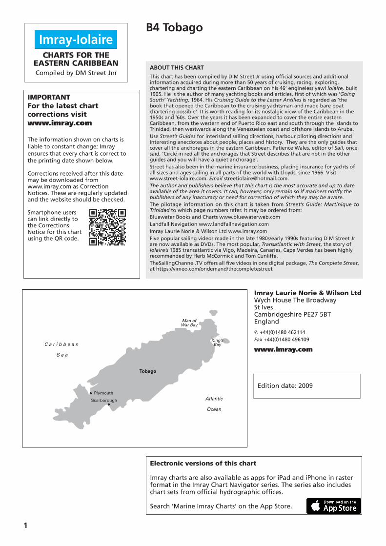
Tobago
Scarborough
Plymouth
King’s Bay
Man ofWar Bay
C a r i b b e a n
S e a
Atlantic
Ocean
Imray-IolaireCHARTS FOR THE
EASTERN CARIBBEANCompiled by DM Street Jnr
IMPORTANT For the latest chartcorrections visit www.imray.com
The information shown on charts isliable to constant change; Imrayensures that every chart is correct tothe printing date shown below.
Corrections received after this datemay be downloaded from www.imray.com as Correction Notices. These are regularly updated and the website should be checked.
Smartphone userscan link directly tothe CorrectionsNotice for this chartusing the QR code.
Electronic versions of this chart
Imray charts are also available as apps for iPad and iPhone in rasterformat in the Imray Chart Navigator series. The series also includeschart sets from official hydrographic offices.
Search ‘Marine Imray Charts’ on the App Store.
B4 Tobago GENERAL CAUTIONSYachtsmen navigating this area arereminded that whilst most of the region hasbeen resurveyed in the last 50 years much ofthe data is of 19th-century origin. Since then,topography above and below the water maywell have been altered by natural causessuch as volcanic eruptions, movement ofsandbanks, the growth of coral etc. Thischart must therefore be used with caution.Inshore navigation should only beundertaken in good light when the sun ishigh. Navigational aids (buoys, beacons andlights) are notable for their absence and/orunreliability.It is important to read the sailing and pilot
directions for the area concerned the nightbefore, in order to plan the next day's run,and to calculate your departure in time toguarantee arrival at the next anchoragewhile the sun is still high.It is also important on interisland passages
to allow for the set of the current. Stay towindward of the rhumb line. Take backbearings until you can see the island ahead.Take GPS readings every half hour and plotthem on the chart, make sure you stay towindward of the rhumb line between yourstarting point and your anchorage. Allcourses given in the text are rhumb lines.Do not enter strange harbours at night. Many lights are unreliable.Norie and Wilson Sailing Directions to theCaribbean (1817) state, ‘When passing toleeward of the high islands stay within twopistol shots distance of shore or sevenleagues (21 miles) off.’ Still as true today asit was in 1817.
Tides and Currents (see also Street’s Transatlantic CrossingGuide)Heading north or south, the current is on thebeam, setting you off your rhumb line coursean appreciable amount. When headingnorth or south, the Equatorial current issetting you to the west. It is negated (andoccasionally, with spring tides, eliminated) bythe tidal current. You must remember thatthe flood tide sets to the east, the ebb tidesets to the west. Current (knots)Boat Speed 1.5 1.2 1.0 0.8(knots) 2 37º 31º 27º 22º 3 27º 22º 18º 15º 4 21º 17º 14º 11º 5 17º 13º 11º 9º 6 14º 11º 9º 8º 7 12º 10º 8º 7º 8 11º 9º 7º 6º 9 9º 8º 6º 5º 10 9º 7º 6º 5º Degrees of set leeway
It is extremely important to allow for theset of the current which is made up of theeasterly wind blown Equatorial current,reinforced by the ebb tide or partially (andoccasionally completely) negated by theflood tide. Taking advantage of a weather-
going current can change a passage frombeing a real hard slog, to a glorious reach.With tide and current setting you toleeward, you will have to sail 010° to 015°above the rhumb line, but if it is setting youto windward you will be able to sail a course010° to 015° to leeward of the rhumb line.This makes a difference of 020° to 030° oftenchanging a dead beat to an easy close reach.This often makes the difference betweenslamming into it, or an eased sheet reach,really flying. This is particularly true from StVincent to St Lucia, Martinique to Dominica,Deshaies (Guadeloupe) to English Harbour(Antigua). If you plan your passages so that you have
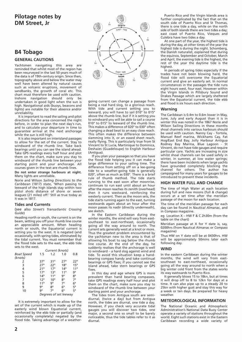
the flood tide helping you it can make alarge difference to your sailing time. Thedifference from setting off on a lee-goingtide to a weather-going tide is generally020°, often as much as 030°. There is a briefrule of thumb method. The tide startsrunning to the east soon after moonrise,continues to run east until about an hourafter the moon reaches its zenith (overhead)then it runs westward, reinforcing thewesterly current. Then as the moon sets, thetide starts running again to the east, turningwestwards again about an hour after themoon passes its nadir (directly underneath),see sketch. In the Eastern Caribbean during the
winter months, the wind will vary from east-southeast to east-northeast, occasionallygoing all the way around to north. Thecurrent sets generally west at a knot or more.Thus the greatest problem encountered bythe yachtsman new to the area is that ofallowing his boat to sag below the rhumbline course. At the end of the day, hesuddenly realises that the anchorage is wellto windward – a hard slog against wind andtide. To avoid this situation keep a hand-bearing compass handy and take continualbearings or GPS fixes; if you cannot see theisland ahead, take stern bearings or GPSfixes. In this day and age where GPS is more
prevalent than hand bearing compasses,take GPS readings every half hour and plotthem on the chart, make sure you stay towindward of the rhumb line between yourstarting point and your anchorage. The tides trom Antigua south are semi-
diurnal, (twice a day) but from Antiguanorth, the tides are diurnal, one tide a day.However, if you check very accurate tidalgauges you will discover two tides, onemajor, a second one so small to be barelynoticeable, thus the tide tables refer to it asdiurnal.
Puerto Rico and the Virgin Islands area isfurther complicated by the fact that on thesouth side of Puerto Rico and St Thomas,there is one tide a day, while on the northside of both islands there are two tides a day;east coast of Puerto Rico, Vieques andCulebra have two tides a day. At one part of the year, the highest tide is
during the day, at other times of the year thehighest tide is during the night. Schomberg,the Danish naturalist, explained that duringthe equinox, September and October, Marchand April, the evening tide is the highest, therest of the year the daytime tide is thehighest. In periods of spring tides especially if the
trades have not been blowing hard, theflood tide will overcome the Equatorialcurrent and give an easterly set. In normalcircumstances in the passages the tide runseight hours west, four east. However withinthe Virgin Islands in Pillsbury Sound andDrakes Passage which are largely shelteredfrom the Equatorial current, the tide ebband flood is six hours each direction.
Warning The Caribbean is 0.4m to 0.6m lower in May,June, July and early August than it is inwinter this was noted in the 1867 Norie andWilson Sailing Directions in these monthsshoal channels into various harbours shouldbe used with caution. Nanny Cay - Tortola,Manuel Reef marina, Wickhams Cay, FatHog/East End Bay, Jolly Harbour AntiguaRodney Bay Marina, Blue Lagoon - StVincent, do not have tide gauges and requireparticular care. Yachts are increasing in sizewhilst shoal channels can be used safely inwinter, in summer, at low water springs;there have been incidents when large yachtshave grounded completely blocking thechannel for others. The author hascampaigned for many years for gauges to beintroduced to prevent these incidents.
HIGH WATER FULL AND CHANGEThe time of High Water at each locationduring full and new moons (full & change)occurs at a set time after the meridianpassage of the moon for each location.The time of the meridian passage for eachday can be found in Nautical Almanac, andin Compass magazine.eg Location X – HW F & C 2h30m (from thetable on the chart) Meridian passage at X for Y date is, say,0200hrs (from Nautical Almanac or Compassmagazine)Thus HW on Y date will be at 0430hrs. HWwill be approximately 50mins later eachfollowing day.
WINDIn the eastern Caribbean during the wintermonths, the wind will vary from east-southeast to east-northeast, occasionallygoing all the way around to north when abig winter cold front from the states worksits way eastwards to Puerto Rico.It generally blows 15 to 18kn, but at times
it will drop off to 8 to 12kn for days at atime. It can also pipe up to a steady 20 to25kn with higher gust and stay this way fora week or ten days. Be prepared for heavyweather.
METEOROLOGICAL INFORMATIONThe National Oceanic and AtmosphericAdministration’s National Data Buoy Centeroperate a variety of stations throughout theworld. Eight such stations exist in the EasternCaribbean recording a wide variety of
2
EAST TIDE
WES
T T
IDEW
EST
TID
E
EAST TIDE
NADIR
ZENITH
1Hr
1Hr
1Hr
1Hr
Pilotage notes by DM Street, Jr

meteorological information. Much of thisdata is available to the yachtsman via theNOBC website. Go towww.ndbc.noaa.gov/Maps/Caribbean andclick on the station you wish to access.Wind velocities from shore stations in the
Eastern Caribbean give little indication ofwinds expected offshore. The weather buoysto the east of the islands will give a goodindication of weather and sea conditions tobe expected in the islands 24 hours later.Buoys to the north will give you
indications of the approach of a groundswell condition but remember that theground swell will approach at 25 to 30kn perhour, so lock on to buoys well north of the islands.Every year Caribbean Compass puts out an
updated version of their list of radio stationsthat give weather information of interest tothe sailor.
GROUND SWELLSWhen ground swells are expected on thenorth coast of Puerto Rico, they arepredicted quite accurately on El Oso SanJuan, Virgin Island news. Add roughlytwenty-four hours for the ground swellpredicted to reach the southern end of theCaribbean.On any beach open to the northwest as far
south as Antigua, there is the danger of theground swell, especially if the beach ashoreis quite steep and the sand really soft. Istrongly advise either a Bahamian moor ormoor bow-and-stern when anchoring off it.If the ground swell comes in during the
night when on a single anchor it will pivotthe boat around in the surf and within a fewminutes the boat is driven on shore.Ground swells are completely
independent of the Caribbean weathersystems; they are generated by storms in thenorth Atlantic. The season is mid-October tothe end of March though very occasionallyground swells will appear in April.For cruising therefore, May is fine: no
hurricanes; no ground swell. June the same,though there is a risk of hurricanes. July isgood but watch out for hurricanes.
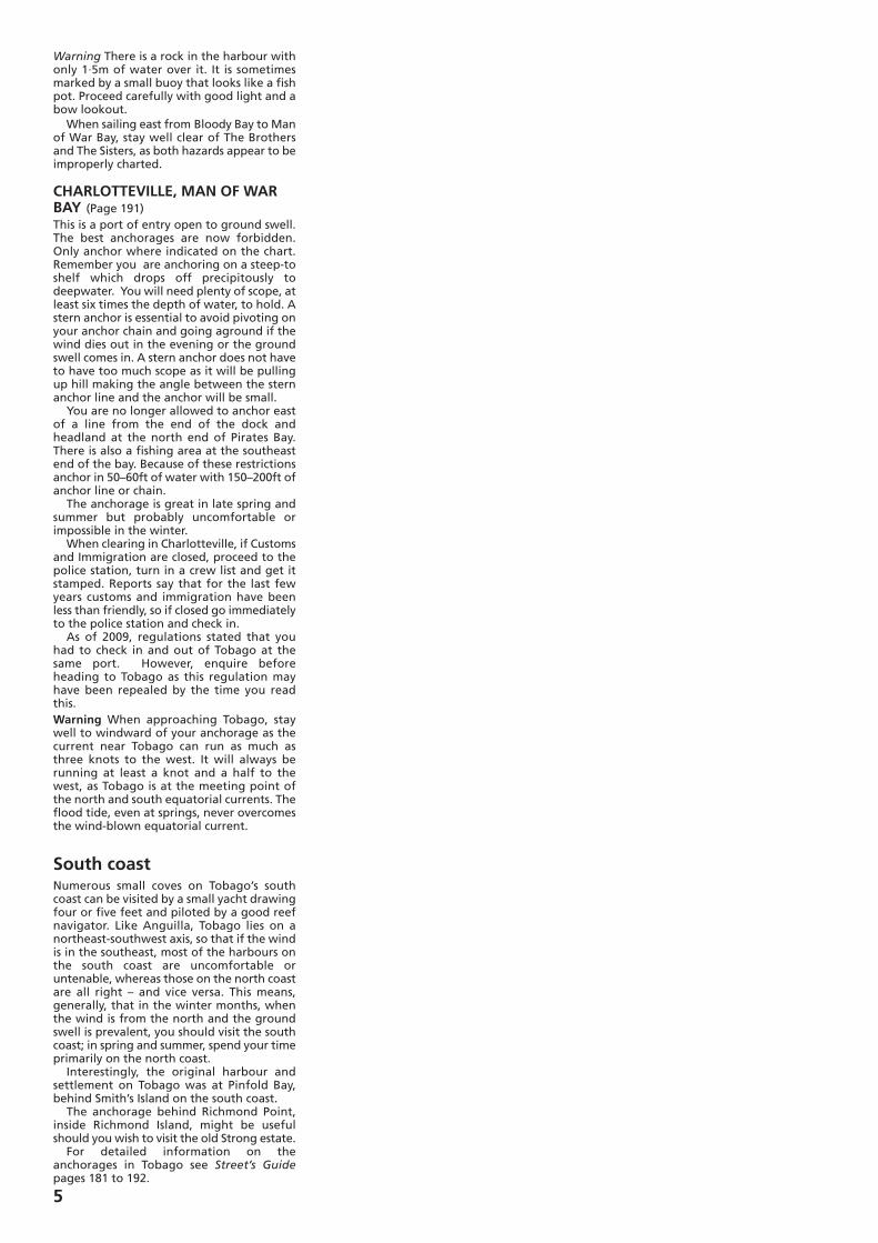
BAHAMIAN MOORBahamian moor is useful if you are anchoredwhere there is a reversing tide that willovercome the wind when the tide is runningeastwards, or anchored off a beach that isexposed to the ground swell. If you are on aBahamian moor you will swing in a circlethat is equal to the length of the boat. Once anchored, back down with the
engine, slacking the anchor line or chainuntil you have veered (eased) plenty of scope(line) then take a second anchor, carry it backto the stern, drop it, shorten up on bowanchor until you have the correct amount ofscope, then take a strain on the anchor youhave dropped off the stern (but lead the
rode through the bow chock), and secure.Now that you have moored between twoanchors there is no danger of swingingashore when the wind dies out at night.
RIG FOR DOWNWIND
Take a spare line (spare sheet or dock line) atleast the length of the boat, secure it to theend of the main boom, pull it tight andsecure the line to the goose neck, coil andhang up the excess. Once underway andrunning downwind, broad off, free it fromthe goose neck, take it forward outside allthe rigging through a bow chock and secureit to mooring cleat or anchor windlass. It isthen almost impossible to jibe. Rig theheadsail to a spinnaker pole of the oppositeside, sail down wind wing and wing. If youdo not have a spinnaker pole and thepreventer is rigged really tight, a goodhelmsman can sail slightly by the lee andkeep the headsail filled. A useful rig whenheading westward in the Virgins, Puerto Ricowestwards from Antigua. The above is a jury rig that can be done
with the material found on a bare boat. Ifyou own your own boat do a proper job asdescribed below.If heading westwards from the eastern
Caribbean to Columbia or Panama rig aproper easily rigged and unrigged mainboom preventer.
Main-boom preventer/foreguyEvery year, numerous sailors are injured, andsome are killed, as the result of inadvertantjibes. These accidents can be avoided withthe use of a preventer/foreguy on the mainboom.For downwind sailing, the first and most
essential piece of gear is a strong preventeron the main boom that can be easily riggedand unrigged.To set up an effective preventer, you need
a strong bail on the end of the main boom,preferably angled forward at about 45°.If you don’t have a suitable bail, you can
use a loop of line to make a strop. Make theloop long enough that you can wrap it twicearound the boom, tuck one end of the loopthrough the other, and work it tight. (Thetwo wraps will ensure the strop doesn’t slipalong the boom.) To make the loop, take apiece of line of the appropriate length, tiethe ends together with a sheet bend, andmouse the tails of the knot with electricaltape.
Secure a wire (or a length of high-tech linelike Spectra or Dyneema) to the bail or strop.This is the permanent part of the boompreventer. It should be about a foot shorterthan the distance from the bail to thegooseneck and have a thimble spliced intoits gooseneck end. A lashing line tied intothe thimble will allow you to snug thepreventer up to the gooseneck and tightunder the boom when it’s not in use.Lead two spinnaker-pole foreguys, one
each side of the boat, through blocks at thestemhead or the end of the bowsprit. Clipthe snap shackles to lifeline stanchionsabreast of the mast and run the other endsaft to the cockpit.To set up the preventer when you’re
sailing, all you have to do is untie the lineunder the boom from the gooseneck and clipthe snap shackle of the leeward foreguy intothe thimble eye. Make the lashing line longenough that you can tie it loosely to thelifeline and use it as a retrieval line when it’stime for a jibe.Once the wind gets on the quarter and the
boom is well eased, connect the preventerand set it up tight using a winch. If no winchis available, over-ease the mainsheet, take upon the foreguy, then re-trim the main tomake the foreguy tight. A jibe is now all butimpossible.
Key to the diagram1. Main boom2. Mainsheet3. Bail or strop4. Wire preventer5. Light line
3
Arc of Swing
BAHAMIAN MOOR
BOW AND STERN MOORING
1
45
3
2
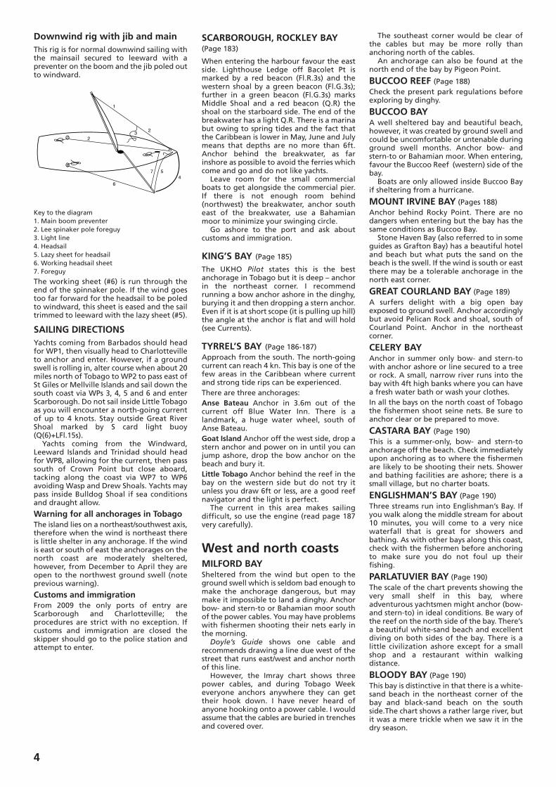
Downwind rig with jib and mainThis rig is for normal downwind sailing withthe mainsail secured to leeward with apreventer on the boom and the jib poled outto windward.
Key to the diagram1. Main boom preventer2. Lee spinaker pole foreguy3. Light line4. Headsail5. Lazy sheet for headsail6. Working headsail sheet7. Foreguy
The working sheet (#6) is run through theend of the spinnaker pole. If the wind goestoo far forward for the headsail to be poledto windward, this sheet is eased and the sailtrimmed to leeward with the lazy sheet (#5).
SAILING DIRECTIONSYachts coming from Barbados should headfor WP1, then visually head to Charlottevilleto anchor and enter. However, if a groundswell is rolling in, alter course when about 20miles north of Tobago to WP2 to pass east ofSt Giles or Mellville Islands and sail down thesouth coast via WPs 3, 4, 5 and 6 and enterScarborough. Do not sail inside Little Tobagoas you will encounter a north-going currentof up to 4 knots. Stay outside Great RiverShoal marked by S card light buoy(Q(6)+LFl.15s). Yachts coming from the Windward,
Leeward Islands and Trinidad should headfor WP8, allowing for the current, then passsouth of Crown Point but close aboard,tacking along the coast via WP7 to WP6avoiding Wasp and Drew Shoals. Yachts maypass inside Bulldog Shoal if sea conditionsand draught allow.
Warning for all anchorages in TobagoThe island lies on a northeast/southwest axis,therefore when the wind is northeast thereis little shelter in any anchorage. If the windis east or south of east the anchorages on thenorth coast are moderately sheltered,however, from December to April they areopen to the northwest ground swell (noteprevious warning).
Customs and immigrationFrom 2009 the only ports of entry areScarborough and Charlotteville; theprocedures are strict with no exception. Ifcustoms and immigration are closed theskipper should go to the police station andattempt to enter.
SCARBOROUGH, ROCKLEY BAY(Page 183)
When entering the harbour favour the eastside. Lighthouse Ledge off Bacolet Pt ismarked by a red beacon (Fl.R.3s) and thewestern shoal by a green beacon (Fl.G.3s);further in a green beacon (Fl.G.3s) marksMiddle Shoal and a red beacon (Q.R) theshoal on the starboard side. The end of thebreakwater has a light Q.R. There is a marinabut owing to spring tides and the fact thatthe Caribbean is lower in May, June and Julymeans that depths are no more than 6ft.Anchor behind the breakwater, as farinshore as possible to avoid the ferries whichcome and go and do not like yachts.Leave room for the small commercial
boats to get alongside the commercial pier.If there is not enough room behind(northwest) the breakwater, anchor southeast of the breakwater, use a Bahamianmoor to minimize your swinging circle.Go ashore to the port and ask about
customs and immigration.
KING’S BAY (Page 185)
The UKHO Pilot states this is the bestanchorage in Tobago but it is deep – anchorin the northeast corner. I recommendrunning a bow anchor ashore in the dinghy,burying it and then dropping a stern anchor.Even if it is at short scope (it is pulling up hill)the angle at the anchor is flat and will hold(see Currents).
TYRREL’S BAY (Page 186-187)Approach from the south. The north-goingcurrent can reach 4 kn. This bay is one of thefew areas in the Caribbean where currentand strong tide rips can be experienced.There are three anchorages:Anse Bateau Anchor in 3.6m out of thecurrent off Blue Water Inn. There is alandmark, a huge water wheel, south ofAnse Bateau.Goat Island Anchor off the west side, drop astern anchor and power on in until you canjump ashore, drop the bow anchor on thebeach and bury it.Little Tobago Anchor behind the reef in thebay on the western side but do not try itunless you draw 6ft or less, are a good reefnavigator and the light is perfect.The current in this area makes sailing
difficult, so use the engine (read page 187very carefully).
West and north coastsMILFORD BAYSheltered from the wind but open to theground swell which is seldom bad enough tomake the anchorage dangerous, but maymake it impossible to land a dinghy. Anchorbow- and stern-to or Bahamian moor southof the power cables. You may have problemswith fishermen shooting their nets early inthe morning.
Doyle’s Guide shows one cable andrecommends drawing a line due west of thestreet that runs east/west and anchor northof this line.However, the Imray chart shows three
power cables, and during Tobago Weekeveryone anchors anywhere they can gettheir hook down. I have never heard ofanyone hooking onto a power cable. I wouldassume that the cables are buried in trenchesand covered over.
The southeast corner would be clear ofthe cables but may be more rolly thananchoring north of the cables.An anchorage can also be found at the
north end of the bay by Pigeon Point.
BUCCOO REEF (Page 188) Check the present park regulations beforeexploring by dinghy.
BUCCOO BAYA well sheltered bay and beautiful beach,however, it was created by ground swell andcould be uncomfortable or untenable duringground swell months. Anchor bow- andstern-to or Bahamian moor. When entering,favour the Buccoo Reef (western) side of thebay.Boats are only allowed inside Buccoo Bay
if sheltering from a hurricane.
MOUNT IRVINE BAY (Pages 188) Anchor behind Rocky Point. There are nodangers when entering but the bay has thesame conditions as Buccoo Bay.Stone Haven Bay (also referred to in some
guides as Grafton Bay) has a beautiful hoteland beach but what puts the sand on thebeach is the swell. If the wind is south or eastthere may be a tolerable anchorage in thenorth east corner.
GREAT COURLAND BAY (Page 189) A surfers delight with a big open bayexposed to ground swell. Anchor accordinglybut avoid Pelican Rock and shoal, south ofCourland Point. Anchor in the northeastcorner.
CELERY BAYAnchor in summer only bow- and stern-towith anchor ashore or line secured to a treeor rock. A small, narrow river runs into thebay with 4ft high banks where you can havea fresh water bath or wash your clothes. In all the bays on the north coast of Tobagothe fishermen shoot seine nets. Be sure toanchor clear or be prepared to move.
CASTARA BAY (Page 190) This is a summer-only, bow- and stern-toanchorage off the beach. Check immediatelyupon anchoring as to where the fishermenare likely to be shooting their nets. Showerand bathing facilities are ashore; there is asmall village, but no charter boats.
ENGLISHMAN’S BAY (Page 190) Three streams run into Englishman’s Bay. Ifyou walk along the middle stream for about10 minutes, you will come to a very nicewaterfall that is great for showers andbathing. As with other bays along this coast,check with the fishermen before anchoringto make sure you do not foul up theirfishing.
PARLATUVIER BAY (Page 190) The scale of the chart prevents showing thevery small shelf in this bay, whereadventurous yachtsmen might anchor (bow-and stern-to) in ideal conditions. Be wary ofthe reef on the north side of the bay. There’sa beautiful white-sand beach and excellentdiving on both sides of the bay. There is alittle civilization ashore except for a smallshop and a restaurant within walkingdistance.
BLOODY BAY (Page 190) This bay is distinctive in that there is a white-sand beach in the northeast corner of thebay and black-sand beach on the southside.The chart shows a rather large river, butit was a mere trickle when we saw it in thedry season.
4
6
1
23
4
57
2
Warning There is a rock in the harbour withonly 1·5m of water over it. It is sometimesmarked by a small buoy that looks like a fishpot. Proceed carefully with good light and abow lookout.When sailing east from Bloody Bay to Man
of War Bay, stay well clear of The Brothersand The Sisters, as both hazards appear to beimproperly charted.
CHARLOTTEVILLE, MAN OF WARBAY (Page 191)This is a port of entry open to ground swell.The best anchorages are now forbidden.Only anchor where indicated on the chart.Remember you are anchoring on a steep-toshelf which drops off precipitously todeepwater. You will need plenty of scope, atleast six times the depth of water, to hold. Astern anchor is essential to avoid pivoting onyour anchor chain and going aground if thewind dies out in the evening or the groundswell comes in. A stern anchor does not haveto have too much scope as it will be pullingup hill making the angle between the sternanchor line and the anchor will be small. You are no longer allowed to anchor east
of a line from the end of the dock andheadland at the north end of Pirates Bay.There is also a fishing area at the southeastend of the bay. Because of these restrictionsanchor in 50–60ft of water with 150–200ft ofanchor line or chain.The anchorage is great in late spring and
summer but probably uncomfortable orimpossible in the winter.When clearing in Charlotteville, if Customs
and Immigration are closed, proceed to thepolice station, turn in a crew list and get itstamped. Reports say that for the last fewyears customs and immigration have beenless than friendly, so if closed go immediatelyto the police station and check in.As of 2009, regulations stated that you
had to check in and out of Tobago at thesame port. However, enquire beforeheading to Tobago as this regulation mayhave been repealed by the time you readthis.Warning When approaching Tobago, staywell to windward of your anchorage as thecurrent near Tobago can run as much asthree knots to the west. It will always berunning at least a knot and a half to thewest, as Tobago is at the meeting point ofthe north and south equatorial currents. Theflood tide, even at springs, never overcomesthe wind-blown equatorial current.
South coastNumerous small coves on Tobago’s southcoast can be visited by a small yacht drawingfour or five feet and piloted by a good reefnavigator. Like Anguilla, Tobago lies on anortheast-southwest axis, so that if the windis in the southeast, most of the harbours onthe south coast are uncomfortable oruntenable, whereas those on the north coastare all right – and vice versa. This means,generally, that in the winter months, whenthe wind is from the north and the groundswell is prevalent, you should visit the southcoast; in spring and summer, spend your timeprimarily on the north coast.Interestingly, the original harbour and
settlement on Tobago was at Pinfold Bay,behind Smith’s Island on the south coast.The anchorage behind Richmond Point,
inside Richmond Island, might be usefulshould you wish to visit the old Strong estate.For detailed information on the
anchorages in Tobago see Street’s Guidepages 181 to 192.
5