B.3 DA03 Maidstone Rural West - Kent · B.3 DA03 Maidstone Rural West . Maidstone Stage 1 SWMP :...
4
2012s6729 - Maidstone Stage 1 SWMP FINAL (v1.0 October 2013) vi B.3 DA03 Maidstone Rural West
Transcript of B.3 DA03 Maidstone Rural West - Kent · B.3 DA03 Maidstone Rural West . Maidstone Stage 1 SWMP :...

2012s6729 - Maidstone Stage 1 SWMP FINAL (v1.0 October 2013) vi
B.3 DA03 Maidstone Rural West
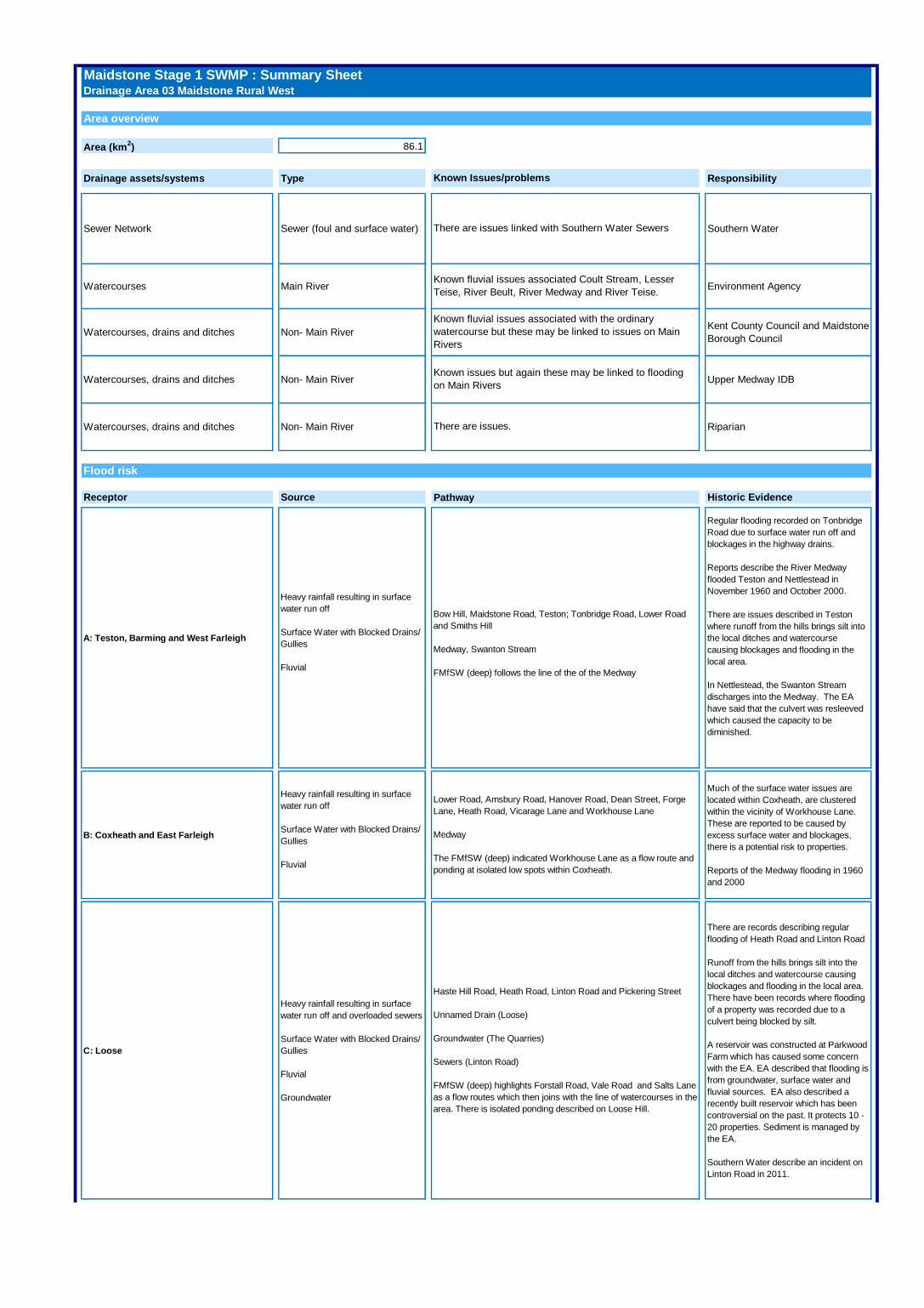
Maidstone Stage 1 SWMP : Summary SheetDrainage Area 03 Maidstone Rural West
Area overview
Area (km2) 86.1
Drainage assets/systems Type Responsibility
Sewer Network Sewer (foul and surface water) Southern Water
Watercourses Main River Environment Agency
Watercourses, drains and ditches Non- Main River Kent County Council and Maidstone
Borough Council
Watercourses, drains and ditches Non- Main River Upper Medway IDB
Watercourses, drains and ditches Non- Main River Riparian
Flood risk
Receptor Source Historic Evidence
A: Teston, Barming and West Farleigh
Heavy rainfall resulting in surface
water run off
Surface Water with Blocked Drains/
Gullies
Fluvial
Regular flooding recorded on Tonbridge
Road due to surface water run off and
blockages in the highway drains.
Reports describe the River Medway
flooded Teston and Nettlestead in
November 1960 and October 2000.
There are issues described in Teston
where runoff from the hills brings silt into
the local ditches and watercourse
causing blockages and flooding in the
local area.
In Nettlestead, the Swanton Stream
discharges into the Medway. The EA
have said that the culvert was resleeved
which caused the capacity to be
diminished.
B: Coxheath and East Farleigh
Heavy rainfall resulting in surface
water run off
Surface Water with Blocked Drains/
Gullies
Fluvial
Much of the surface water issues are
located within Coxheath, are clustered
within the vicinity of Workhouse Lane.
These are reported to be caused by
excess surface water and blockages,
there is a potential risk to properties.
Reports of the Medway flooding in 1960
and 2000
C: Loose
Heavy rainfall resulting in surface
water run off and overloaded sewers
Surface Water with Blocked Drains/
Gullies
Fluvial
Groundwater
There are records describing regular
flooding of Heath Road and Linton Road
Runoff from the hills brings silt into the
local ditches and watercourse causing
blockages and flooding in the local area.
There have been records where flooding
of a property was recorded due to a
culvert being blocked by silt.
A reservoir was constructed at Parkwood
Farm which has caused some concern
with the EA. EA described that flooding is
from groundwater, surface water and
fluvial sources. EA also described a
recently built reservoir which has been
controversial on the past. It protects 10 -
20 properties. Sediment is managed by
the EA.
Southern Water describe an incident on
Linton Road in 2011.
Lower Road, Amsbury Road, Hanover Road, Dean Street, Forge
Lane, Heath Road, Vicarage Lane and Workhouse Lane
Medway
The FMfSW (deep) indicated Workhouse Lane as a flow route and
ponding at isolated low spots within Coxheath.
Haste Hill Road, Heath Road, Linton Road and Pickering Street
Unnamed Drain (Loose)
Groundwater (The Quarries)
Sewers (Linton Road)
FMfSW (deep) highlights Forstall Road, Vale Road and Salts Lane
as a flow routes which then joins with the line of watercourses in the
area. There is isolated ponding described on Loose Hill.
Bow Hill, Maidstone Road, Teston; Tonbridge Road, Lower Road
and Smiths Hill
Medway, Swanton Stream
FMfSW (deep) follows the line of the of the Medway
Pathway
Known Issues/problems
There are issues linked with Southern Water Sewers
Known fluvial issues associated Coult Stream, Lesser
Teise, River Beult, River Medway and River Teise.
Known fluvial issues associated with the ordinary
watercourse but these may be linked to issues on Main
Rivers
Known issues but again these may be linked to flooding
on Main Rivers
There are issues.
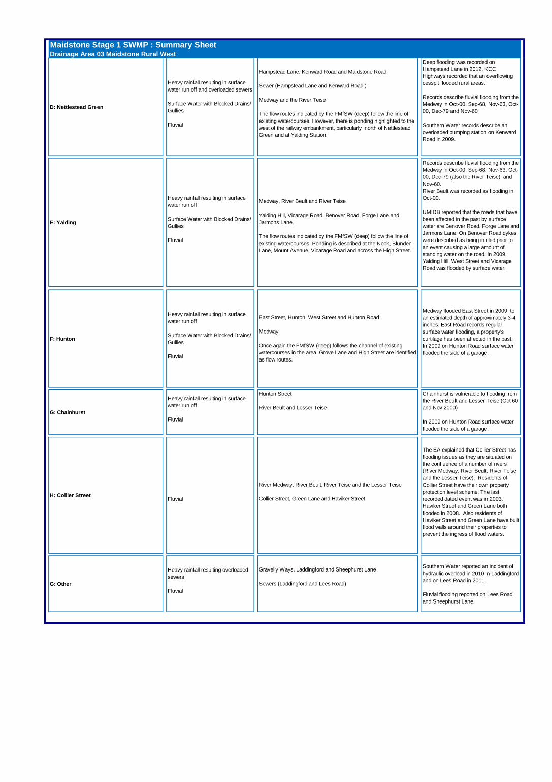
Maidstone Stage 1 SWMP : Summary SheetDrainage Area 03 Maidstone Rural West
D: Nettlestead Green
Heavy rainfall resulting in surface
water run off and overloaded sewers
Surface Water with Blocked Drains/
Gullies
Fluvial
Deep flooding was recorded on
Hampstead Lane in 2012. KCC
Highways recorded that an overflowing
cesspit flooded rural areas.
Records describe fluvial flooding from the
Medway in Oct-00, Sep-68, Nov-63, Oct-
00, Dec-79 and Nov-60
Southern Water records describe an
overloaded pumping station on Kenward
Road in 2009.
E: Yalding
Heavy rainfall resulting in surface
water run off
Surface Water with Blocked Drains/
Gullies
Fluvial
Records describe fluvial flooding from the
Medway in Oct-00, Sep-68, Nov-63, Oct-
00, Dec-79 (also the River Teise) and
Nov-60.
River Beult was recorded as flooding in
Oct-00.
UMIDB reported that the roads that have
been affected in the past by surface
water are Benover Road, Forge Lane and
Jarmons Lane. On Benover Road dykes
were described as being infilled prior to
an event causing a large amount of
standing water on the road. In 2009,
Yalding Hill, West Street and Vicarage
Road was flooded by surface water.
F: Hunton
Heavy rainfall resulting in surface
water run off
Surface Water with Blocked Drains/
Gullies
Fluvial
Medway flooded East Street in 2009 to
an estimated depth of approximately 3-4
inches. East Road records regular
surface water flooding, a property's
curtilage has been affected in the past.
In 2009 on Hunton Road surface water
flooded the side of a garage.
G: Chainhurst
Heavy rainfall resulting in surface
water run off
Fluvial
Chainhurst is vulnerable to flooding from
the River Beult and Lesser Teise (Oct 60
and Nov 2000)
In 2009 on Hunton Road surface water
flooded the side of a garage.
H: Collier StreetFluvial
The EA explained that Collier Street has
flooding issues as they are situated on
the confluence of a number of rivers
(River Medway, River Beult, River Teise
and the Lesser Teise). Residents of
Collier Street have their own property
protection level scheme. The last
recorded dated event was in 2003.
Haviker Street and Green Lane both
flooded in 2008. Also residents of
Haviker Street and Green Lane have built
flood walls around their properties to
prevent the ingress of flood waters.
G: Other
Heavy rainfall resulting overloaded
sewers
Fluvial
Southern Water reported an incident of
hydraulic overload in 2010 in Laddingford
and on Lees Road in 2011.
Fluvial flooding reported on Lees Road
and Sheephurst Lane.
Hunton Street
River Beult and Lesser Teise
East Street, Hunton, West Street and Hunton Road
Medway
Once again the FMfSW (deep) follows the channel of existing
watercourses in the area. Grove Lane and High Street are identified
as flow routes.
River Medway, River Beult, River Teise and the Lesser Teise
Collier Street, Green Lane and Haviker Street
Gravelly Ways, Laddingford and Sheephurst Lane
Sewers (Laddingford and Lees Road)
Hampstead Lane, Kenward Road and Maidstone Road
Sewer (Hampstead Lane and Kenward Road )
Medway and the River Teise
The flow routes indicated by the FMfSW (deep) follow the line of
existing watercourses. However, there is ponding highlighted to the
west of the railway embankment, particularly north of Nettlestead
Green and at Yalding Station.
Medway, River Beult and River Teise
Yalding Hill, Vicarage Road, Benover Road, Forge Lane and
Jarmons Lane.
The flow routes indicated by the FMfSW (deep) follow the line of
existing watercourses. Ponding is described at the Nook, Blunden
Lane, Mount Avenue, Vicarage Road and across the High Street.
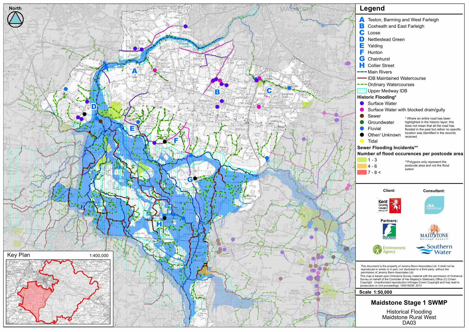
EF
H
D
G
AΒ C
This document is the property of Jeremy Benn Associates Ltd. It shall not bereproduced in whole or in part, nor disclosed to a third party, without thepermission of Jeremy Benn Associates Ltd.
North
This map is based upon Ordnance Survey material with the permission of OrdnanceSurvey on behalf of the Controller of Her Majesty's Stationery Office (C) CrownCopyright. Unauthorised reproduction infringes Crown Copyright and may lead toprosecution or civil proceedings. 100019238. 2013
Legend
1:50,000Scale
Maidstone Rural WestHistorical Flooding
3DA0
Key Plan 1:400,000
Maidstone Stage 1 SWMP
A Teston, Barming and West FarleighΒ Coxheath and East FarleighC LooseD Nettlestead GreenE YaldingF HuntonG ChainhurstH Collier StreetMain RiversIDB Maintained WatercourseOrdinary WatercoursesUpper Medway IDB
Historic Flooding*! Surface Water! Surface Water with blocked drain/gully! Sewer! Groundwater! Fluvial! Other/ Unknown! Tidal
Sewer Flooding Incidents**
1 - 34 - 67 - 8 <
Number of flood occurences per postcode area
Client: Consultant:
Partners:
* Where an entire road has beenhighlighted in the historic layer; thisdoes not mean that all the road hasflooded in the past but rather no specificlocation was identified in the recordsreceived.
**Polygons only represent thepostcode area and not the floodextent