
b 123 permitted uses in future land use categories - 25 Return to Table of Contents B. 1. PERMITTED...
55
IV - 25 Return to Table of Contents B. 1. PERMITTED USES IN FUTURE LAND USE CATEGORIES This section identifies those uses permitted in the future land use categories established within the Broward County Land Use Plan. Local government zoning as to permitted uses and densities must be in compliance with these permitted uses and the Future Broward County Land Use Plan Map (Series) designation. Local government zoning as to permitted uses which is in compliance with a certified land use plan shall be in compliance with the Broward County Land Use Plan. A certified local land use plan and land development regulations adopted by a local government may prohibit or restrict any of the land uses permitted within any land use category in the Broward County Land Use Plan. Areas designated on the Future Broward County Land Use Plan Map (Series) for particular uses are approximate. The exact boundaries for zoning will be determined by the local government within the reasonable limits of the designation on the map. Local governments will determine those uses which will be permitted, allowed by special exceptions or not permitted from those uses listed below. AGRICULTURAL USE Agricultural areas are designated on the Future Broward County Land Use Plan Map (Series), consistent with Objective 7.02.00, to promote agriculture and agricultural related uses. Residential development may occur within specific limits. Uses permitted in areas designated agricultural are as follows: 1. Agricultural and related uses may be broadly defined by the local government to include the following: cultivation of crops, groves, thoroughbred and pleasure horse ranches, fish breeding areas, tree and plant nurseries, cattle ranches, and other similar activities. 2. Residential uses at a maximum of one (1) dwelling unit per two (2) net acres or greater or one (1) dwelling unit per two and one-half (2 1/2) gross acres or greater. Land submerged by water during the majority of the year shall not count as part of the two (2) net acres, unless the submerged land is a pond entirely confined within the parcel. Clustering of dwelling units may be permitted if the following conditions are met: a. the parcel is developed under a unified development plan; b. the areas from which density is transferred are relinquished of all future development rights; and c. the arrangement of clustered dwelling units is in confor- mance with locally established development standards.
Transcript of b 123 permitted uses in future land use categories - 25 Return to Table of Contents B. 1. PERMITTED...

IV - 25
Return to Table of Contents
B. 1. PERMITTED USES IN FUTURE LAND USE CATEGORIES This section identifies those uses permitted in the future land use categories established within the Broward County Land Use Plan. Local government zoning as to permitted uses and densities must be in compliance with these permitted uses and the Future Broward County Land Use Plan Map (Series) designation. Local government zoning as to permitted uses which is in compliance with a certified land use plan shall be in compliance with the Broward County Land Use Plan. A certified local land use plan and land development regulations adopted by a local government may prohibit or restrict any of the land uses permitted within any land use category in the Broward County Land Use Plan. Areas designated on the Future Broward County Land Use Plan Map (Series) for particular uses are approximate. The exact boundaries for zoning will be determined by the local government within the reasonable limits of the designation on the map. Local governments will determine those uses which will be permitted, allowed by special exceptions or not permitted from those uses listed below. AGRICULTURAL USE Agricultural areas are designated on the Future Broward County Land Use Plan Map (Series), consistent with Objective 7.02.00, to promote agriculture and agricultural related uses. Residential development may occur within specific limits. Uses permitted in areas designated agricultural are as follows:
1. Agricultural and related uses may be broadly defined by the local government to include the following: cultivation of crops, groves, thoroughbred and pleasure horse ranches, fish breeding areas, tree and plant nurseries, cattle ranches, and other similar activities.
2. Residential uses at a maximum of one (1) dwelling unit per two (2) net acres or
greater or one (1) dwelling unit per two and one-half (2 1/2) gross acres or greater. Land submerged by water during the majority of the year shall not count as part of the two (2) net acres, unless the submerged land is a pond entirely confined within the parcel. Clustering of dwelling units may be permitted if the following conditions are met:
a. the parcel is developed under a unified development plan; b. the areas from which density is transferred are relinquished
of all future development rights; and c. the arrangement of clustered dwelling units is in confor-
mance with locally established development standards.
IV - 26
3. Recreation and open space uses. 4. Cemeteries.
5. Community facilities such as, but not limited to, schools, day care centers, religious institutions, clinics, governmental administration, police and fire facilities, libraries and civic centers not to exceed twenty (20) acres in size. Parcels zoned or otherwise approved for community facility uses consistent with existing local regulations and permits as of December 14, 1999, (the adoption date of the text amendment), and thereafter with extended, amended, renewed regulations and permits, may be developed for such uses pursuant to such regulations and permits. Community facilities parcels shall be separated by a minimum of 1,000 feet and shall be contiguous to a limited access/controlled facility or an arterial facility as designated on the Broward County Trafficways Plan.
6. Mining operations consistent with existing local regulations and permits as of
December 31, 1993, and thereafter with extended, amended or renewed permits (including permits granted as a result of a reapplication that was filed prior to expiration of the existing permit) may continue pursuant to such permits and regulations.
7. Transportation facilities.
8. a. Special Residential Facility Category (1) development as defined in the Special Residential Facilities Permitted Uses subsection of the Plan Implementation Requirements section of the Broward County Land Use Plan, subject to the requirements of this land use category for the location of one (1) dwelling unit.
b. Special Residential Facility Category (2) development as defined in
the Special Residential Facilities Permitted Uses subsection of the Plan Implementation Requirements section of the Broward County Land Use Plan, subject to the requirements of this land use category for the location of one (1) dwelling unit.
9. Communication facilities. 10. Public utilities such as, but not limited to, water and wastewater treatment plants,
pumping stations, electrical substations and electric lines and drainage facilities and structures, excluding electrical power plants.

IV - 27
COMMERCIAL USE The areas designated for commercial use on the Future Broward County Land Use Plan Map (Series), consistent with Objective 2.01.00, provide land area for business, office, retail, service and other commercial enterprises which support the resident and tourist populations of Broward County. Uses permitted in areas designated commercial are as follows: 1. Retail uses. 2. Office and business uses.
3. Wholesale, storage, light fabricating and warehouse uses, if deemed appropriate by the local jurisdiction.
4. Hotels, motels and similar lodging.
5. Recreation and open space, cemeteries, and commercial recreation uses. 6. Community facilities. 7. a. Special Residential Facility Category (2) development as defined
in the Special Residential Facilities Permitted Uses subsection of the Plan Implementation Requirements section of the Broward County Land Use Plan; subject to the allocation of two (2) reserve or flexibility units in accordance with the Special Residential Facility provisions and policies for the application of these units as contained in the “Administrative Rules Document: Broward County Land Use Plan.”
b. Special Residential Facility Category (3) development as defined
in the Special Residential Facilities Permitted Uses subsection of the Plan Implementation Requirements section of the Broward County Land Use Plan; subject to the allocation of reserve units or flexibility units in accordance with the Special Residential Facility provisions and policies for the application of these units as contained in the “Administrative Rules Document: Broward County Land Use Plan”; each flexibility or reserve unit shall permit two (2) sleeping rooms regardless of the number of kitchens or baths.
8. Non-residential Agricultural uses.
IV - 28
9. Residential uses are permitted, without the need to amend the local land use plan map, provided that the local government applies flexibility or reserve units to the parcel in the following manner:
a. The residential floor area of mixed commercial/residential
structures does not exceed 50% of the total floor area of the building; and/or
b. The first floor of mixed commercial/residential structures is
totally confined to commercial uses; and/or c. For parcels 5 acres in size or less, free-standing or mixed-
use multi-family structures are permitted; within areas designated on the County Plan as Urban Infill, Urban Redevelopment or Downtown Revitalization Areas or Chapter 163 Redevelopment Areas, free-standing or mixed-use multi-family residential uses are permitted on parcels 10 acres in size or less; and/or
d. For mixed commercial/residential developments greater
than 5 acres in size (or 10 acres within areas designated on the County Plan as Urban Infill, Urban Redevelopment or Downtown Revitalization Areas or Chapter 163 Redevelopment Areas) free-standing or mixed-use multi-family residential uses are permitted provided that the gross residential acreage does not exceed 5 acres (10 acres within areas designated on the County Plan as Urban Infill, Urban Redevelopment or Downtown Revitalization Areas or Chapter 163 Redevelopment Areas) or 40% of the total gross acreage of the commercially designated parcel, whichever is greater, and that the entire mixed commercial/residential development be governed by specific zoning regulations that establish criteria to ensure proper integration and compatibility of land uses within and surrounding the development; and/or
e. Residential units within the same structure as commercial
uses for the owner, manager or caretaker of the commercial uses may be located in areas designated commercial without the application of flexibility units or reserve units.

IV - 29
10. Recreational vehicle park sites at a maximum density of ten (10) sites per gross acre if permanent location of recreational vehicles on the site is permitted by the local land development regulations, or twenty (20) sites per gross acre if such permanent location is prohibited by the local land development regulations; subject to allocation by the local government of available flexibility or reserve units.
11. Transportation facilities. 12. Communication facilities. 13. Utilities, excluding landfills and electrical power plants. COMMERCIAL RECREATION USE Commercial Recreation areas are designated on the Future Broward County Land Use Plan Map (Series), consistent with Objective 2.03.00, to accommodate major public and private commercial recreation facilities which offer recreational opportunities to the residents and tourists of Broward County. Although some of these facilities operate as an adjunct to or an integral part of other types of development, most of these facilities were conceived as profit-making enterprises. Commercial recreation ventures in Broward County can be divided into two categories; golf courses and commercial recreation associated with structures and/or indoor facilities. Those uses permitted in areas designated commercial recreation are as follows:
1. Outdoor and indoor recreation facilities such as active recreation complexes, marinas, stadiums, jai-alai frontons, bowling alleys, golf courses, and dog and horse racing facilities.
2. Accessory facilities, including outdoor and indoor recreation facilities,
that are determined by the local government to be an integral part of and supportive to the primary recreation facility (excluding residential uses).
3. Hotels, motels and similar lodging ancillary to the primary commercial
recreation use. 4. Other active and passive recreation uses.
5. Recreational vehicle sites at a maximum density of ten (10) sites per gross acre if permanent location of recreational vehicles on the site is permitted by the local land development regulations, or twenty (20) sites per gross acre if such location is prohibited by the local land development regulations; subject to the allocation by the local government of available flexibility or reserve units.
IV - 30
COMMUNITY FACILITIES USE Community Facilities areas are designated on the Future Broward County Land Use Plan Map (Series), consistent with Objective 8.04.00, to provide a full range of regional and community uses such as educational, medical, governmental, religious, civic, cultural, judicial, and correctional facilities. Community facilities may be permitted at the discretion of the local government in areas designated residential, commercial, office park, agricultural, industrial, regional activity center and employment center. Civic and cultural buildings may also be permitted in areas designated for recreation and open space use if they are ancillary to the primary recreation use of the site. Uses permitted in areas designated community facilities are as follows:
1. Community facilities uses such as schools, churches, hospitals, governmental administration, police and fire stations, libraries, civic centers, prisons and courts, nursing homes, cemeteries, and parks and recreation facilities.
2. a. Special Residential Facility Category (2) development as defined in
the “Definitions” subsection of the Plan Implementation Require-ments section of the Broward County Land Use Plan; subject to the allocation of two (2) reserve or flexibility units in accordance with the Special Residential Facilities provisions and policies for application of these units as contained in the “Administrative Rules Document: Broward County Land Use Plan.”
b. Special Residential Facility Category (3) development as defined in
the “Definitions” subsection of the Plan Implementation Require-ments section of the Broward County Land Use Plan; subject to the allocation of reserve units or flexibility units in accordance with the Special Residential Facilities provisions and policies for application of these units as explained in the “Administrative Rules Document: Broward County Land Use Plan”; each flexibility or reserve unit shall permit two (2) sleeping rooms regardless of the number of kitchens or baths.
CONSERVATION USE Conservation areas are designated on the Future Broward County Land Use Plan Map (Series), consistent with Objective 6.02.00, to protect major reserve water supply areas and natural reservations.
IV - 31
Reserve Water Supply Areas The major reserve water supply areas include, but are not limited to, the 790 square miles of Broward County west of Levees 33, 35A, 36, L-37 and L-35. All uses, other than active outdoor recreation uses described below, in the Reserve Water Supply Areas shall be subject to authorization by the South Florida Water Management District, as set forth in applicable laws, rules and regulations. Those uses permitted in areas designated Conservation - Reserve Water Supply Areas are as follows:
1. Structures such as dikes, berms, levees, canals, ditches, locks, gates, pumping stations, fire towers, monitoring and telecommunications facilities used for flood control, drainage, water quality preservation/ enhancement, environmental protection and restoration, wetlands mitigation, mosquito control, fire control and the storage and conservation of water, notwithstanding ancillary impacts to the immediate area where construction and operational impacts will occur.
2. Active outdoor recreation uses such as hunting, fishing, boating, air boating and
off road vehicles, pursuant to State and Federal regulations. 3. Boat ramps and docks and camping facilities.
4. Passive outdoor recreational uses such as wildlife sanctuaries and feeding stations, nature centers and trails, outdoor research stations and walkways.
5. State and Federal Indian Reservations, including the Miccosukee leased area.
6. Utilities, transportation and communications facilities, specifically excluding
hazardous liquid pipelines and electrical power plants, which do not impair the natural environment or disturb the natural ecosystem of the area and which are not in conflict with applicable water management and wildlife protection policies of local, state and federal agencies.
7. Surface impoundments that store water at depths not to exceed 12 feet.
8. Construction and operation of water quality treatment facilities and areas and ancillary facilities. These may range from passive biological treatment to technologically intense forms of treatment including, but not limited to, chemical treatment/filtration facilities. Areas required to provide surge basins to hold water awaiting treatment are also allowed.
9. Structures designed to promote the storage of water underground, which may
include aquifer storage and recovery systems, pumps designed to promote groundwater recharge, and seepage management features, which may include curtain wall or other types of technology.

IV - 32
Natural Reservations Natural Reservations are designated for Conservation use on the Future Broward County Land Use Plan Map (Series) and include public lands which are conservation areas operated by contractual agreement with or managed by a federal, state, regional, local government or non-profit agencies. Natural Reservations that are designated for Conservation use on the Future Broward County Land Use Plan Map (Series) include:
a. Birch State Park (historic dunes area, coastal dune lakes, coastal hammock and mangrove area)
b. Bonnet House (mangrove and coastal strand hammock areas) c. Deerfield Island (mangrove area) d. Easterlin County Park (nature trail area) e. Fern Forest Nature Center f. Hacienda Flores (mitigation area) g. North Beach Park (conservation easement) h. Pond Apple Slough i. Secret Woods Nature Center j. Snyder Park (tropical hardwood hammock area) k. Tivoli Sand Pine l. Tradewinds South (cypress area) m. Treetops Park (hammock area) n. West Lake County Park (mangrove areas) Those uses permitted in Natural Reservation areas designated Conservation are as follows:
1. Passive outdoor recreational uses such as wildlife sanctuaries and feeding stations, nature centers and trails, outdoor research stations and walkways.
2. Uses which do not impair the natural environment or disturb the natural
ecosystem of the area and which are not in conflict with any applicable contractual agreement or management policies of the federal, state, regional, county, municipal or non-profit agency which manages the Natural Reservation.

IV - 33
ELECTRICAL GENERATION FACILITIES USE Electrical Generation Facilities Uses are designated on the Future Broward County Land Use Plan Map (Series), consistent with Objective 8.09.00, to ensure the availability of land for electrical power plants and associated ancillary uses are adequate to meet the current and future needs of Broward County’s population. Uses permitted in the areas designated Electrical Generation Facilities are as follows:
1. Electrical power plants as defined in Section IV, Plan Implementation Requirements, A. Definitions.
2. Other uses determined to be ancillary to the primary uses described in
(1). The following uses may also be permitted in the areas designated electrical generation facility as long as the location of the uses do not preclude or adversely affect the future use of the surrounding areas for electrical generation facilities: 3. Recreation and open space uses. EMPLOYMENT CENTER USES In general, Employment Center areas are designated on the Future Broward County Land Use Map (Series), consistent with Objective 3.02.00, to encourage types of development which may be compatible with residential and other less intensive land uses, and which would support high technology and service-based activities which Broward County has attracted in recent years, as well as the tourist-oriented segment of Broward County’s economy. This type of category is further refined into “Employment Center-Low” and “Employment Center-High.” The “Employ-ment Center-Low” category does not allow manufacturing uses and is designed to be inherently compatible with residential uses. The “Employment Center-High” category will allow light manufacturing uses. A. Employment Center-Low 1. Principal Uses: a. office uses b. research businesses, including medical and research laboratories c. fabrication and assembly d. hotels, motels and similar lodging e. restaurants and personal services f. community facilities g. communication facilities h. non-residential Agricultural uses
i. Residential uses are permitted without the need to amend the local land use plan map, provided that the local government applies flexibility or reserve units to the parcel in the following manner:
IV - 34
(1) For parcels 5 acres in size or less, free-standing or mixed-use
multi-family structures are permitted; within areas designated on the County Land Use Plan as Urban Infill, Urban Redevelopment or Downtown Revitalization Areas or Chapter 163 Redevelopment Areas, free-standing or mixed-use multi-family residential uses are permitted on parcels 10 acres in size or less.
(2) For mixed use developments greater than 5 acres in size (or
10 acres within areas designated on the County Land Use Plan as Urban Infill, Urban Redevelopment or Downtown Revitalization Areas or Chapter 163 Redevelopment Areas) free-standing or mixed-use multi-family residential uses are permitted provided that the gross residential acreage does not exceed 5 acres (10 acres within areas designated on the County Land Use Plan as Urban Infill, Urban Redevelopment or Downtown Revitalization Areas or Chapter 163 Rede-velopment Areas) or 40% of the total gross acreage of the employment center designated parcel, whichever is greater, and that the entire mixed use development be governed by specific zoning regulations that establish criteria to ensure proper integration and compatibility of land uses within and surrounding the development.
2. Accessory Uses (Limited to less than fifty percent (50%) of the site): a. transportation and utilities, excluding electrical power plants b. storage c. retail within buildings devoted to principal uses d. recreation and open space uses
3. Commercial and retail business uses may also be permitted if certified by the Broward County Planning Council in the local land use plan, subject to the review and approval requirements of Policy 13.01.10 and as long as the total area of these uses does not consume more than 20 percent of the employment center land designated on the Future Broward County Land Use Plan Map (Series) within a flexibility zone, and as long as the location of these uses does not preclude or adversely affect the future use of surrounding areas for employment center use.
B. Employment Center-High 1. Principal Uses: a. light manufacturing, fabrication and assembly b. office uses
IV - 35
c. research businesses, including medical and research laboratories
d. hotels, motels and similar lodging e. restaurants and personal services f. community facilities g. communication facilities h. non-residential Agricultural uses
i. Residential uses are permitted without the need to amend the local land use plan map, provided that the local government applies flexibility or reserve units to the parcel in the following manner:
(1) For parcels 5 acres in size or less, free-standing or
mixed-use multi-family structures are permitted; within areas designated on the County Land Use Plan as Urban Infill, Urban Redevelopment or Downtown Revitalization Areas or Chapter 163 Redevelopment Areas, free-standing or mixed-use multi-family residential uses are permitted on parcels 10 acres in size or less.
(2) For mixed use developments greater than 5 acres
in size (or 10 acres within areas designated on the County Plan as Urban Infill, Urban Redevelop-ment or Downtown Revitalization Areas or Chapter 163 Redevelopment Areas) free-standing or mixed-use multi-family residential uses are permitted provided that the gross residential acreage does not exceed 5 acres (10 acres within areas designated on the County Plan as Urban Infill, Urban Redevelopment or Downtown Revitalization Areas or Chapter 163 Redevelop-ment Areas) or 40% of the total gross acreage of the employment center designated parcel, whichever is greater, and that the entire mixed use development be governed by specific zoning regulations that establish criteria to ensure proper integration and compatibility of land uses within and surrounding the development.
2. Accessory Uses (Limited to less than fifty percent (50%) of the site): a. transportation and utilities, excluding electrical power plants b. storage c. retail within buildings devoted to principal uses d. recreation and open space uses

IV - 36
3. Commercial and retail business uses may also be permitted if certified by the Broward County Planning Council in the local land use plan, subject to the review and approval requirements of Policy 13.01.10 and as long as the total area of these uses does not consume more than 20 percent of the employment center land designated on the Future Broward County Land Use Plan Map (Series) within a flexibility zone, and as long as the location of these uses does not preclude or adversely affect the future use of surrounding areas for employment center use.
INDUSTRIAL USE The purpose of reserving land for industrial uses, consistent with Objective 3.01.00, is to provide opportunity for the retention and expansion of Broward County's economic base activities. Although other uses are permitted in areas designated industrial, at least 80 percent of such land area must be devoted to industrial use, such as manufacturing, warehouse distribution, research and development, or other substantial employment based activities. Uses permitted in areas designated industrial are as follows: 1. Light and heavy industrial uses.
2. Heavy commercial uses including new and used automobile, truck, motorcycle, boat and trailer display, sales, and service; newspaper, magazine, and printing plants; bakeries, carpentry, cabinet shops and other trade shops; motion picture studios; ice houses; propane gas sales and repair; and salvage yards.
3. Educational, scientific and industrial research facilities, research
laboratories, and medical or dental laboratories. 4. Office uses. 5. Transportation facilities.
6. Recreation and open space, cemeteries, and commercial recreation uses, as long as the location of these uses does not preclude or adversely affect the future use of surrounding areas for industry.
7. Community facilities. 8. Non-residential Agricultural uses.
9. Ancillary commercial uses within buildings devoted to primary industrial uses.
10. Wholesaling uses.

IV - 37
11. The following uses may also be permitted if certified by the Broward County Planning Council in the local land use plan, subject to the review and approval requirements of Policy 13.01.10 and as long as the total area of these uses does not consume more than 20 percent of the industrial land designated on the Future Broward County Land Use Plan Map (Series) within a flexibility zone, and as long as the location of these uses does not preclude or adversely affect the future use of surrounding areas for industrial uses:
a. Commercial and retail business uses. b. Hotel, motel and similar lodging. 12. Mining. 13. Communication facilities. 14. Utilities, excluding electrical power plants. 15. Residential units within the same structure as industrial uses for the owner,
manager or caretaker of the industrial uses may be located in areas designated industrial without the application of flexibility units or reserve units.
LOCAL ACTIVITY CENTER Consistent with Objective 10.03.00, the intent of the Local Activity Center land use designation is to support a balanced mix of land uses characterized by compactness, pedestrian friendly design, neighborhood-scale and framed by architecture and landscape design appropriate to local history and ecology. Development patterns within Local Activity Centers shall generally reflect planning and design principles such as walkable neighborhoods oriented around the five-minute walk, primary orientation toward public transit systems, a centrally located community-serving land use or land uses and greater integration of housing, employment, shopping and recreation at the neighborhood level. For an area to qualify as a Local Activity Center, the following criteria must be met:
1. A Local Activity Center shall be a specific geographic area not exceeding 160 gross contiguous acres, unless located within an approved Chapter 163, Florida Statutes, Redevelopment Area. At such time as 75% of the originally designated Local Activity Center is developed/redeveloped, consistent with Objective 10.03.00, an expansion to a subject Local Activity Center up to 100% may be proposed.
IV - 38
2. The density and intensity of land uses permitted within a proposed Local Activity Center shall be specified for inclusion within the Plan Implementation Requirements section of the Broward County Land Use Plan.
3. Uses proposed within a Local Activity Center shall include residential uses
and park land and/or open space. One or more other uses such as commercial, civic, institutional, or employment-based activity shall also be included within a Local Activity Center.
4. Park land must reflect no net loss of acreage of existing and designated parks
within the proposed Local Activity Center. Park and open space land may include squares, greenbelts, greenways and playgrounds; ill-defined residual areas such as buffers and berms, for purposes of this criteria, are not considered park land or open space.
5. A proposed Local Activity Center must have a geographic configuration of
appropriate depth and frontage to support the location of uses in a manner oriented around the five-minute (i.e. quarter-mile) walk. Multiple nodes of activity oriented around the five-minute (i.e. quarter-mile) walk may be included within one Local Activity Center.
6. Seventy-five percent (75%) of the land within a Local Activity Center must be
located within a quarter-mile of mass transit or multi-modal facilities or are included within an adopted plan to be located within a quarter-mile of mass transit or multi-modal facilities upon buildout of the Local Activity Center. Local governments shall ensure convenient access to mass transit, community shuttle or multi-modal facilities where such facilities are in place or planned to be in place at the time the Local Activity Center is proposed. Where such facilities are not in place or planned to be in place at the time of the proposal, the local government shall require design standards in the local land use element for a Local Activity Center that ensure that the primary priority is a safe, comfortable and attractive pedestrian environment that will allow for convenient interconnection to transit, will reduce the number of automobile trips internally and will ultimately support an integrated multi-modal transportation system.
7. A proposed Local Activity Center shall demonstrate consistency with the
goals, objectives and policies and other requirements of the Broward County Land Use Plan.
8. An interlocal agreement between the municipality and Broward County must
be executed no later than six months from the effective date of the adoption of a Local Activity Center which provides that monitoring of development activity and enforcement of permitted land use densities and intensities shall be the responsibility of the affected municipality.

IV - 39
The following areas have been designated Local Activity Centers within the Broward County Land Use Plan: Downtown Coral Springs Acreage: Approximately 138.1 acres General Location: South of Northwest 35 Street and Broken Woods Drive, north
of Northwest 31 Court, west of Northwest 90 Avenue, and east of Northwest 99 Way; bisected by University Drive and Sample Road.
Density and Intensity of Land Uses: The total impact of development growth will generate no
more than 2,802 vehicle trips at the P.M. peak hour* Residential Land Uses 2,400 high-rise† dwelling units Commercial Land Uses 1,200,000 square feet Office Land Uses 2,000,000 square feet Library 72,000 square feet School 1,600 students Government Office 100,000 square feet Hotel 750 rooms Movie Theater 80,000 square feet Recreation and Open Space Land Uses 3.0 acres minimum
*Per Institute of Transportation Engineers (ITE) traffic generation equations.
Gulfstream Park – Hallandale Beach Acreage: Approximately 65.5 acres General Location: East side of U.S.1/Federal Highway, south of Hallandale
Beach Boulevard.
__________________
† Note: High-rise units are defined as four (4) stories or more, consistent with the effective Broward County Land Development Code definition at the time of the adoption of the Broward County Land Use Plan amendment.

IV - 40
Density and Intensity of Land Uses: Residential Land Uses 1,500 high-rise† dwelling units Commercial Land Uses 750,000 square feet Office Land Uses 140,000 square feet Movie Cinema 2,500 seats Hotel 500 rooms Recreation and Open Space 1.2 acres minimum Commercial Recreation 580 maximum number of p.m. peak hour trips through trade-offs with other uses Lauderdale Lakes Downtown Acreage: Approximately 140 acres General Location: East of Northwest 43 Avenue, south of Northwest 36 Street,
west of Northwest 35 Avenue and north of Northwest 29 Street.
Density and Intensity of Land Uses: Residential Land Uses 3,000 dwelling units* Commercial Land Uses 500,000 square feet Hotel 300 rooms Community Facilities Land Uses 50,000 square feet Recreation and Open Space 5.0 acres minimum
*Consisting of 1,500 high rise† dwelling units, 500 garden apartments and 1,000 townhouses. The City shall not issue residential building permits until the execution and implementation of a legally enforceable mechanism, such as a tri-party interlocal agreement, regarding a student station fee. Additional high rise units may be substituted for garden and/or townhouse units provided that (i) not more than 3,000 total units are developed in the LAC and (ii) any such substitution is approved by the City Commission.
__________________
† Note: High-rise units are defined as four (4) stories or more, consistent with the effective Broward County Land Development Code definition at the time of the adoption of the Broward County Land Use Plan amendment.

IV - 41
Oakland Park Local Activity Center: Acreage: Approximately 148.2 acres General Location: South of Northeast 42 Street, north of Oakland Park
Boulevard, west of Northeast 13 Avenue and east of Northeast 10 Avenue.
Density and Intensity of Land Uses: Residential Land Uses 1,800 dwelling units* Commercial Land Uses 400,000 square feet Office Land Uses 125,000 square feet Community Facilities Land Uses 100,000 square feet Employment Center (High) Land Uses 200,000 square feet Recreation and Open Space Land Uses 5.47 acres minimum
(Includes the City’s proposed Downtown Park located in the 3900 block of North Dixie Highway that consists of 3.21 acres. Acquisition of the recreation and open space site was accommodated through the Broward County Safe Parks and Land Preservation Bond Program.)
*Consisting of 80 single-family homes, 120 duplex, 700 villas, 500 townhomes and 400 garden apartments. High-rise†
units may be substituted for the above units, if approved by the City Commission.
Pembroke Pines City Center Acreage: Approximately 146.37 acres General Location: Bound on the north by Pines Boulevard, on the east by Palm
Avenue and on the south by Washington Street.
__________________
† Note: High-rise units are defined as four (4) stories or more, consistent with the effective Broward County Land Development Code definition at the time of the adoption of the Broward County Land Use Plan amendment.

IV - 42
Density and Intensity of Land Uses: Residential Land Uses 1,365 dwelling units* Commercial Land Uses 265,000 square feet Office Land Uses 120,000 square feet Hotel 350 rooms Recreation and Open Space 2.5 acres minimum
*Consisting of 675 high-rise† dwelling units (of which 250 of these dwelling units would be affordable housing units**), 275 townhouse dwelling units and 415 multi-family dwelling units.
**For the purposes of the Pines City Center LAC, “Affordable Housing” shall mean housing for which monthly rents or monthly mortgage payments (including taxes and insurance) do not exceed 30 percent of an amount representing 120% of the median incomes adjusted for family size for all households within the City of Pembroke Pines; provided, however, that the definition of Affordable Housing shall also include “Workforce Housing” or any similar concept if adopted and defined as part of the Broward County Land Use Plan.
Remarks: Site is a center of governmental employment activity. Plantation Redevelopment Area - State Road 7/U.S. 441 Acreage: Approximately 345.8 acres General Location: South of the northern municipal boundary (approximately one
block north of Sunrise Boulevard) to north of the southern municipal boundary (Davie Boulevard/Peters Road), west of the eastern municipal boundary and east of Northwest 43 Avenue.
__________________
† Note: High-rise units are defined as four (4) stories or more, consistent with the effective Broward County Land Development Code definition at the time of the adoption of the Broward County Land Use Plan amendment.
IV - 43
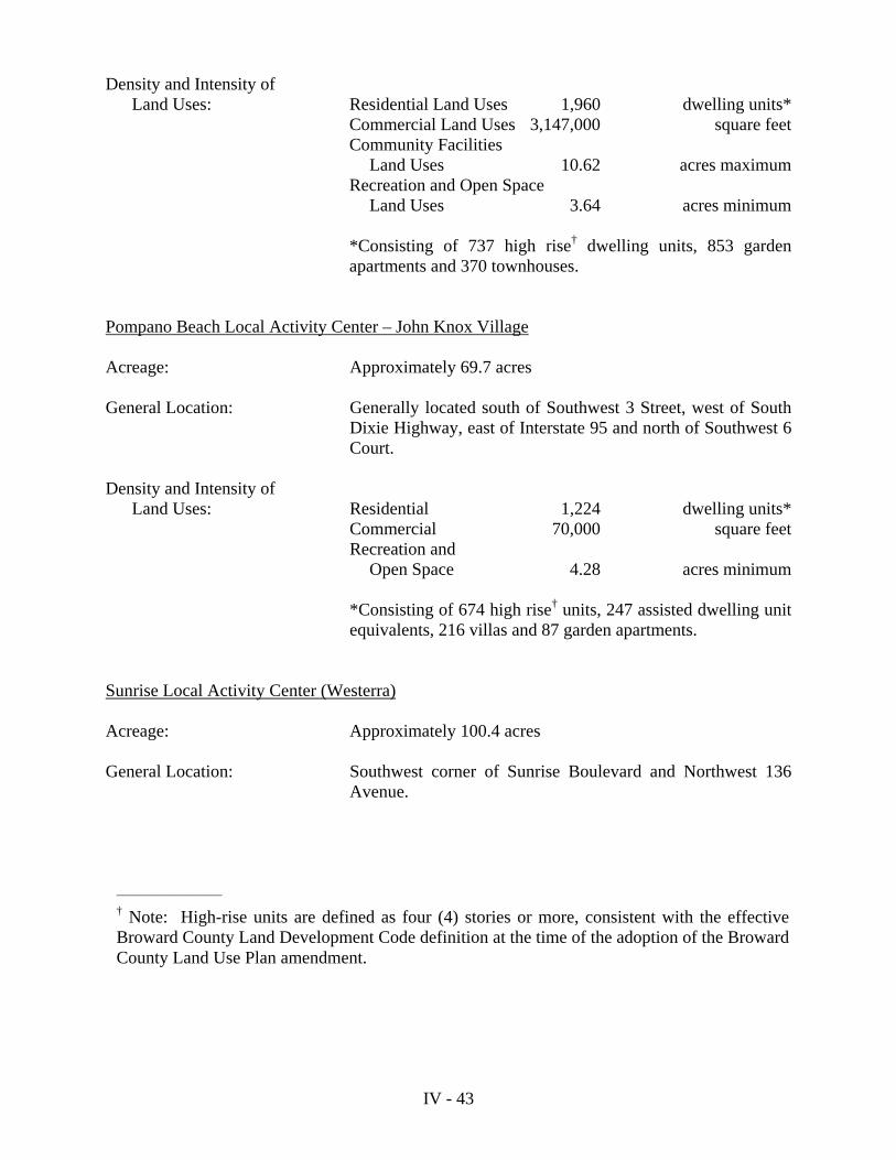
Density and Intensity of Land Uses: Residential Land Uses 1,960 dwelling units* Commercial Land Uses 3,147,000 square feet Community Facilities Land Uses 10.62 acres maximum Recreation and Open Space Land Uses 3.64 acres minimum
*Consisting of 737 high rise† dwelling units, 853 garden apartments and 370 townhouses.
Pompano Beach Local Activity Center – John Knox Village Acreage: Approximately 69.7 acres General Location: Generally located south of Southwest 3 Street, west of South
Dixie Highway, east of Interstate 95 and north of Southwest 6 Court.
Density and Intensity of Land Uses: Residential 1,224 dwelling units* Commercial 70,000 square feet Recreation and Open Space 4.28 acres minimum *Consisting of 674 high rise† units, 247 assisted dwelling unit
equivalents, 216 villas and 87 garden apartments. Sunrise Local Activity Center (Westerra) Acreage: Approximately 100.4 acres General Location: Southwest corner of Sunrise Boulevard and Northwest 136
Avenue.
__________________
† Note: High-rise units are defined as four (4) stories or more, consistent with the effective Broward County Land Development Code definition at the time of the adoption of the Broward County Land Use Plan amendment.
IV - 44
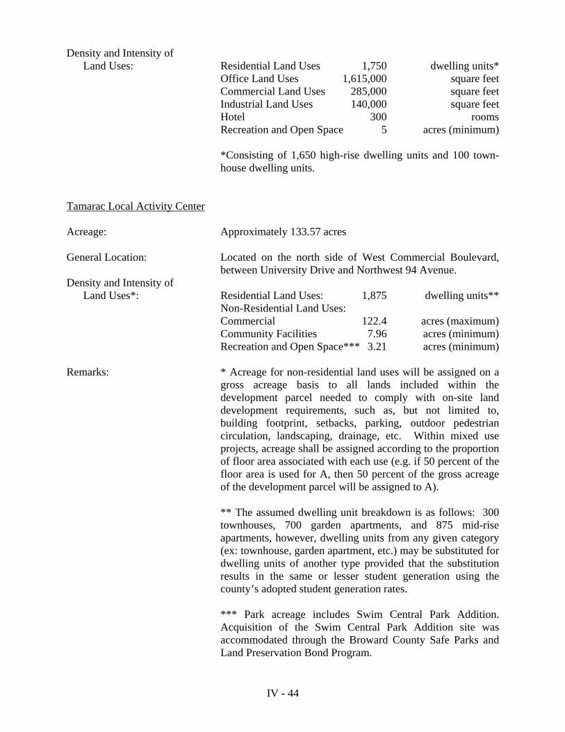
Density and Intensity of Land Uses: Residential Land Uses 1,750 dwelling units* Office Land Uses 1,615,000 square feet Commercial Land Uses 285,000 square feet Industrial Land Uses 140,000 square feet Hotel 300 rooms Recreation and Open Space 5 acres (minimum)
*Consisting of 1,650 high-rise dwelling units and 100 town- house dwelling units.
Tamarac Local Activity Center Acreage: Approximately 133.57 acres General Location: Located on the north side of West Commercial Boulevard,
between University Drive and Northwest 94 Avenue. Density and Intensity of Land Uses*: Residential Land Uses: 1,875 dwelling units** Non-Residential Land Uses: Commercial 122.4 acres (maximum) Community Facilities 7.96 acres (minimum) Recreation and Open Space*** 3.21 acres (minimum) Remarks: * Acreage for non-residential land uses will be assigned on a
gross acreage basis to all lands included within the development parcel needed to comply with on-site land development requirements, such as, but not limited to, building footprint, setbacks, parking, outdoor pedestrian circulation, landscaping, drainage, etc. Within mixed use projects, acreage shall be assigned according to the proportion of floor area associated with each use (e.g. if 50 percent of the floor area is used for A, then 50 percent of the gross acreage of the development parcel will be assigned to A).
** The assumed dwelling unit breakdown is as follows: 300
townhouses, 700 garden apartments, and 875 mid-rise apartments, however, dwelling units from any given category (ex: townhouse, garden apartment, etc.) may be substituted for dwelling units of another type provided that the substitution results in the same or lesser student generation using the county’s adopted student generation rates.
*** Park acreage includes Swim Central Park Addition.
Acquisition of the Swim Central Park Addition site was accommodated through the Broward County Safe Parks and Land Preservation Bond Program.

IV - 45
MINING USE Mining uses are designated on the future Broward County Land Use Plan Map (Series) to identify mining uses consistent with Objective 9.06.00 in order to ensure that mining operations are compatible with existing surrounding and planned land uses. Uses permitted in areas designated mining are as follows:
1. Mining, also including crushing, batching, mixing and forming of mined materials. 2. Transportation and Communication Facilities and Easements.
3. Community Facilities and Utilities, excluding electrical power plants. MIXED USE - RESIDENTIAL Within the Mixed Use – Residential categories, urban form could include several variations; vertical mixed use, where commercial/retail uses are located on the ground floor with residential uses located on upper floors. It may also include horizontal (attached) mixed use; where separate uses are located side by side in the same building. In addition, it may include horizontal (detached) mixed use; where separate uses are located in separate buildings within the same site.
a. Density and Intensity Standards Mixed Use areas shown on the Future Broward County Land Use Map (Series) according
to four (4) ranges of density and intensity:
The Low 5 Mixed Use (permits up to 5 residential dwelling units per gross acre and a FAR of 1.0 for combined development - residential and nonresidential).
The Medium 16 Mixed Use (permits up to 16 residential dwelling units per gross acre
and a FAR of 1.5 for combined development - residential and nonresidential).
The Medium/High 25 Mixed Use (permits up to 25 residential dwelling units per gross acre and a FAR of 2.0 for combined development - residential and nonresidential).
The High 50 Mixed Use (permits up to 50 residential dwelling units per gross acre
and a FAR of 2.5 for combined development - residential and nonresidential).
The residential density shall not exceed the units per acre and the floor area ratio permitted. There is a minimum of two (2) uses required within the development and a minimum percentage of 10% for any one use. Residential development is a required use. These categories may be applied to parcels up to fifty (50) gross acres in size. For example, a development on one gross acre (43,560 sq. ft.) within an M/U Low Intensity-5 category with a FAR of 1.0 could be represented as follows:

IV - 46
Figure 1 Gross Site Area = One Gross Acre * Net Site Area = 0.9 acre**
* Includes dedicated adjacent public rights-of-way ** Excludes dedicated adjacent public rights-of-way
Floor area ratio calculations are based on the Net Site Area. Net Site Area is the entire acreage of the site located inside the parcel boundary. Residential density is based on gross acreage as defined in the Plan Implementation Requirements of the Broward County Land Use Plan.
b. Design Guidelines
The design guidelines for Mixed Use – Residential shall promote an urban form which creates well integrated land use combinations, balances intensity and density, promotes the safe, interconnectivity of vehicular, pedestrian and other non-motorized movement and promotes the public realm. These guidelines may include:
Buildings should front the street. (zero or minimum setbacks are preferable).
Vehicle parking strategies which lessen conflicts with bicycles and pedestrians
and promote transit usage. (i.e. parking structures, off-site parking, reduced parking ratios, shared parking facilities and parking which does not front the street).
Other design features which promote transit (e.g. integrated transit stop, shelter or
station on site).
A circulation system designed to strengthen bicycle and pedestrian connectivity to all areas of the site/area, including recreation areas, parks, adjacent uses, transit facilities and activity nodes.
Integration of the public realm through open space or urban public plazas and/or
recreational areas. The physical separation, such as walling off neighborhoods from adjacent
development or roadways, is discouraged where it disrupts the connectivity of compatible uses, pedestrian and/or bicycle access. If a buffer is necessary, adequate landscaping could be used in place of a continuous wall.
Use
Percentage of Use
Square Footage of Use
Residential
25.5%
5 units @ 2,000 sq. ft. = 10,000 sq. ft.
Commercial
74.5%
39,204 - 10,000 = 29,204 sq. ft.
Total
100%
39,204 (residential 10,000; commercial 29,204)

IV - 47
Design guidelines shall ensure a mixed use development is compatible with surrounding land uses and/or adjacent adopted Future Land Use Plan designations. These guidelines should address the following:
Complement and support adjacent existing land uses and/or adopted Future Land
Use Plan designations through the effective use of density, massing and other design elements.
Protect the integrity of existing single family neighborhoods through design
elements which maintain consistency and/or improve the aesthetic quality of the neighborhood. (i.e. maintaining an architectural style or quality of building materials and construction predominant in the neighborhood).
Promote connectivity, open space, pedestrian and other non-motorized networks
and landscaped streetscapes. Incorporate designs which are environmentally sensitive (i.e. reduction of
impervious surfaces, alternative material for spillover parking).
c. Uses permitted under the Mixed Use – Residential categories
Under the Mixed Use – Residential categories, all uses which are permitted under the Residential, Commercial, Commercial Recreation, Community Facilities and Employment Center Uses of the Broward County Land Use Plan may be applied. There may be permitted uses within these categories which a municipality could deem inappropriate.
OFFICE PARK USE Office Park areas are designated on the Future Broward County Land Use Plan Map (Series), consistent with Objective 2.02.00, to encourage the location of planned office complexes and corporate headquarters in Broward County. Office Park areas should ensure a campus-like atmosphere with substantial buildings and ample open space. Employee services such as shopping and eating establishments should be allowed, but should be limited to areas within buildings primarily devoted to office use. Uses permitted in areas designated office park are as follows: 1. Offices for uses such as administrative, professional and business purposes. 2. Banking and financial institutions. 3. Educational, scientific and industrial research facilities, research laboratories, and
medical or dental laboratories. 4. Restaurants and personal services which are accessory to the primary office uses. 5. Community facilities.

IV - 48
6. a. Special Residential Facility Category (2) development as defined in the
Special Residential Facilities Permitted Uses subsection of the Plan Implementation Requirements section of the Broward County Land Use Plan; subject to the allocation of two (2) reserve or flexibility units in accordance with the Special Residential Facilities provisions and policies for the application of these units as contained in the “Administrative Rules Document: Broward County Land Use Plan.”
b. Special Residential Facility Category (3) development as defined in the
Special Residential Facilities Permitted Uses subsection of the Plan Implementation Requirements section of the Broward County Land Use Plan; subject to the allocation of reserve units or flexibility units in accordance with the Special Residential Facilities provisions and policies for application of these units as contained in the “Administrative Rules Document: Broward County Land Use Plan”; each flexibility or reserve unit shall permit two (2) sleeping rooms regardless of the number of kitchens or baths.
7. Utilities, excluding sanitary landfills and electrical power plants. 8. Communication facilities. 9. Non-residential Agricultural uses. 10. Recreation and open space uses. 11. Hotels, motels or similar lodging. RECREATION AND OPEN SPACE USE The primary intent of the recreation and open space category, consistent with Objective 5.01.00, is to accommodate recreation and open space uses identified within county-wide and local comprehensive plans to serve public recreation needs. In general, land uses within this category are low intensity in character with a minimum of impervious surface coverage and retain as much natural vegetation and landscape as possible. Areas designated as recreation and open space on the Future Broward County Land Use Plan Map (Series) include existing public and private park sites over five (5) acres, existing cemetery sites, and golf courses intended to remain as permanent open space. Those uses permitted in areas designated recreation and open space are as follows:
1. Passive recreational uses, including, but not limited to: nature centers and trails, scenic areas, wildlife sanctuaries and feeding stations, aquatic preserves, and picnic areas.
2. Golf courses which are intended to remain as permanent open space.
3. Camping grounds and facilities. 4. Cemeteries.

IV - 49
5. Active recreational uses, including, but not limited to: tennis courts, playgrounds, swimming pools, athletic fields and courts, beaches and bikeways. 6. Boat ramps and docks.
7. Outdoor cultural, educational and civic facilities, including, but not limited to: animal exhibits, habitats, bandshells and outdoor classrooms.
8. Civic and cultural buildings may be permitted if they are ancillary to the primary
recreation use of the site.
9. Concessions only when accessory to the above uses. Examples of such concessions are refreshment stands, pro shops, souvenir shops and rental facilities.
REGIONAL ACTIVITY CENTER The Regional Activity Center land use designation, consistent with Objective 10.02.00, is intended to encourage development or redevelopment of areas that are of regional significance. The major purposes of this designation are to facilitate mixed-use development, encourage mass transit, and non-motorized transportation, reduce the need for automobile travel, provide incentives for quality development and give definition to the urban form. This designation will only be applied to areas that are of regional significance. Examples of areas which may be appropriate for the regional activity center designation include downtown and redevelopment areas; regional employment centers, Areawide Developments of Regional Impact; centers for tourism, and areas surrounding regional community facilities such as airports, colleges and universities, convention centers or governmental complexes. For an area to qualify as a Regional Activity Center, or for an existing Regional Activity Center to be amended, the following criteria must be met:
1. The Regional Activity Center shall be a specific geographic area consisting of at least 160 gross contiguous acres. No new Regional Activity Center shall be permitted on the barrier island (the area east of the Intracoastal Waterway).
2. a. The density and intensity of land uses permitted within each Regional Activity
Center shall be specified within the Broward County Land Use Plan.
b. An interlocal agreement between the municipality and Broward County must be executed which provides that monitoring of development activity and enforcement of permitted land use densities and intensities shall be the responsibility of the affected municipality. This provision shall take effect for all areas designated “Regional Activity Center” no later than six months from the effective date of this provision (January 28, 2002).
3. Regional Activity Centers shall include mixed land uses of regional significance,
including residential uses.

IV - 50
4. Regional Activity Centers shall either be the subject of an Areawide Development of Regional Impact, centers of regional tourist activity, employment or education, or provide direct access to existing or proposed airports, ports and rail mass transportation facilities.
5. Each Regional Activity Center shall be a defined geographical area, delineated on
the Future Broward County Land Use Plan Map (Series). Boundaries for all RACs shall be determined following reasonable and logical limits incorporating tracts and parcels that are planned for development and/or redevelopment.
6. To enhance pedestrian/non-motorized activities and connectivity, Regional
Activity Centers shall integrate open space that is accessible to the public (i.e. greenways, public plazas, recreational areas) within the Regional Activity Center.
7. Each Regional Activity Center shall be governed by local land use element
policies which ensure that performance and design standards are adopted within local land development regulations that provide for an interconnected street network, a safe and attractive pedestrian environment and multi-modal transit connections.
8. Each Regional Activity Center shall be governed by local land use element
policies which provide that design standards are adopted within local land development regulations ensuring compatibility between existing and planned land uses within and adjacent to Regional Activity Centers.
9. Prior to submittal by a municipality of a Regional Activity Center amendment to
the Broward County Land Use Plan, the municipality shall ensure that the proposal has been subject to a broad public participation process, including property owners within and surrounding the RAC amendment area. The public participation process should include explanatory information concerning the RAC category and should also include a description of potential effects on individual property rights. Examples of a broad public participation process may include, but not be limited to, the following: mailed notices to affected property owners, advertised public workshops, and meetings targeting the affected property owners, business owners, residents and other stakeholders.
10. Regional Activity Centers (RACs) which are in existence at the time of the
effective date of adoption of PCT 05-8 (September 6, 2005) will not be subject to the revised provisions of this amendment. New RACs or amendments to an existing RAC which increase densities, intensities or expanded boundaries submitted after the effective date of adoption of PCT 05-8 will be subject to the revised provisions.
The following areas have been designated Regional Activity Centers within the Broward County Land Use Plan:

IV - 51
MainStreet – Coconut Creek Acreage: Approximately 500 acres General Location: Bound on the north by Wiles Road, on the south by Sample Road,
on the east by Lyons Road and on the west by State Road 7/U.S. 441.
Density and Intensity of Land Uses: Dania Beach Regional Activity Center Acreage: Approximately 1,344.0 acres General Location: Located east of Interstate 95, between Griffin Road and Sheridan
Street. Density and Intensity of Land Uses* Remarks: Chapter 163 Community Redevelopment Area, provides access to
Fort Lauderdale-Hollywood International Airport and Port Everglades, and is located around the proposed FEC commuter rail alignment.
Residential Land Uses 6,450 multi-family dwelling unitsCommercial Land Uses 3,300,000 square feetOffice Land Uses 1,094,500 square feetCommunity Facilities Uses 303,000 square feetHotel 1,300 roomsConservation 14.7 acresRecreation and Open Space Land Uses 5.0 acres minimum
Residential Land Uses 7,818 dwelling units**Hotel 640 roomsCommercial Land Uses 294.0 acres plus an additional 500,000 square feetIndustrial Land Uses 247.5 acresEmployment Center Land Uses 74.5 acresParks and Recreation Land Uses 40.5 acres minimumCommunity Facilities Land Uses 36.2 acres maximumTransportation Land Uses 6.5 acresConservation Land Uses 2.6 acres minimumUtilities Land Uses 2.5 acres maximum
IV - 52
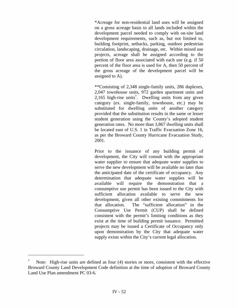
*Acreage for non-residential land uses will be assigned on a gross acreage basis to all lands included within the development parcel needed to comply with on-site land development requirements, such as, but not limited to, building footprint, setbacks, parking, outdoor pedestrian circulation, landscaping, drainage, etc. Within mixed use projects, acreage shall be assigned according to the portion of floor area associated with each use (e.g. if 50 percent of the floor area is used for A, then 50 percent of the gross acreage of the development parcel will be assigned to A).
**Consisting of 2,348 single-family units, 286 duplexes,
2,047 townhouse units, 972 garden apartment units and 2,165 high-rise units†. Dwelling units from any given category (ex. single-family, townhouse, etc.) may be substituted for dwelling units of another category provided that the substitution results in the same or lesser student generation using the County’s adopted student generation rates. No more than 3,867 dwelling units shall be located east of U.S. 1 in Traffic Evacuation Zone 16, as per the Broward County Hurricane Evacuation Study, 2001.
Prior to the issuance of any building permit of
development, the City will consult with the appropriate water supplier to ensure that adequate water supplies to serve the new development will be available no later than the anticipated date of the certificate of occupancy. Any determination that adequate water supplies will be available will require the demonstration that a consumptive use permit has been issued to the City with sufficient allocation available to serve the new development, given all other existing commitments for that allocation. The “sufficient allocation” in the Consumptive Use Permit (CUP) shall be defined consistent with the permit’s limiting conditions as they exist at the time of building permit issuance. Permitted projects may be issued a Certificate of Occupancy only upon demonstration by the City that adequate water supply exists within the City’s current legal allocation.
________________________
† Note: High-rise units are defined as four (4) stories or more, consistent with the effective Broward County Land Development Code definition at the time of adoption of Broward County Land Use Plan amendment PC 03-6.

IV - 53
Town of Davie Regional Activity Center
Acreage: Approximately 2,244 acres General Location: Between University Drive and Florida’s Turnpike, south of State
Road 84 and north of Griffin Road. Density and Intensity of Land Uses: Residential Land Uses: 11,903* dwelling units
(3,174 of the 11,903 units are additional dwelling units permitted by Broward County Land Use Plan (BCLUP) amendment PCT 10-6. These units are prohibited in areas that fall within the Airport’s 60 DNL noise contour per the Runway 9R/27L Environmental Impact Statement, December 2008 2020 Blb. These units are restricted to the following unit types: 2,150 mid-rise, 489 high rise, 300 garden apartments, 150 townhouse/duplex/villa and 85 single family homes).
Commercial Land Uses 3,532,528 square feet Industrial Land Uses 7,629,000 square feet Community Facilities Land Uses 12,388,500 square feet Recreation and Open Space 13 acres minimum
(Wes Griffin Park is restricted to Recreation/Open Space Use)
*Except upon a separate action by Town Council with super-majority vote, the number of maximum residential units shall be phased as follows: 9,787 prior to the year 2013 10,845 prior to the year 2015 11,903 prior to the year 2017
Remarks: 1. The Regional Activity Center land use designation shall
promote and encourage large-scale development and re-development as well as small parcel infill development and redevelopment that facilitates a coordinated and balanced mix of land uses, providing for: educational facilities; a wide selection of housing types for all income levels; shopping opportunities to meet the basic and expanded needs of students, residents, employees and visitors; research, training and other educational support uses; recreation; and employment opportunities including the use of mixed residential/nonresidential uses.

IV - 54
2. All industrial development within wellfield zones of
influence shall comply with the appropriate wellfield protection standards of Chapter 27, Article XIII, of the Broward County Code.
3. Site is a center of regional education and employment
activity. Fort Lauderdale Central Beach Acreage: Approximately 220 acres General Location: South of Sunrise Boulevard, north of Holiday Drive, between the
Atlantic Ocean and the Intracoastal Waterway. Density and Intensity of Land Uses: Development shall be consistent with the Fort Lauderdale Beach
Action Plan, as approved by the Broward County Commission, which restricts development growth to the equivalent of no more than 3,220 peak hour traffic trips. Peak hour trip generation rates are based on the Institute of Transportation Engineers Trip Generation Manual, Fourth Edition. The Bonnet House natural reservation shall be restricted to Conservation land uses.
List of Permitted Uses
Residential Land Uses (maximum of 5,500 dwelling units) Commercial Land Uses Recreation and Open Space Land Uses
Community Facilities Land Uses (All development shall be consistent with the Fort Lauderdale
Beach Action Plan) Remarks: Site is a center of regional tourist activity. Downtown Fort Lauderdale Regional Activity Center Acreage: Approximately 710 acres
General Location: South of Sunrise Boulevard, north of Davie Boulevard, between
U.S. 1/Federal Highway and Northwest 7 Avenue.
IV - 55
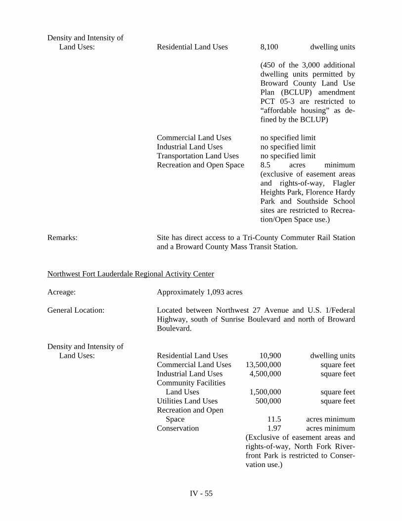
Density and Intensity of Land Uses: Residential Land Uses 8,100 dwelling units
(450 of the 3,000 additional dwelling units permitted by Broward County Land Use Plan (BCLUP) amendment PCT 05-3 are restricted to “affordable housing” as de-fined by the BCLUP)
Commercial Land Uses no specified limit Industrial Land Uses no specified limit Transportation Land Uses no specified limit Recreation and Open Space 8.5 acres minimum
(exclusive of easement areas and rights-of-way, Flagler Heights Park, Florence Hardy Park and Southside School sites are restricted to Recrea-tion/Open Space use.)
Remarks: Site has direct access to a Tri-County Commuter Rail Station
and a Broward County Mass Transit Station. Northwest Fort Lauderdale Regional Activity Center Acreage: Approximately 1,093 acres General Location: Located between Northwest 27 Avenue and U.S. 1/Federal
Highway, south of Sunrise Boulevard and north of Broward Boulevard.
Density and Intensity of Land Uses: Residential Land Uses 10,900 dwelling units Commercial Land Uses 13,500,000 square feet Industrial Land Uses 4,500,000 square feet Community Facilities Land Uses 1,500,000 square feet
Utilities Land Uses 500,000 square feet Recreation and Open Space 11.5 acres minimum Conservation 1.97 acres minimum
(Exclusive of easement areas and rights-of-way, North Fork River-front Park is restricted to Conser-vation use.)
IV - 56
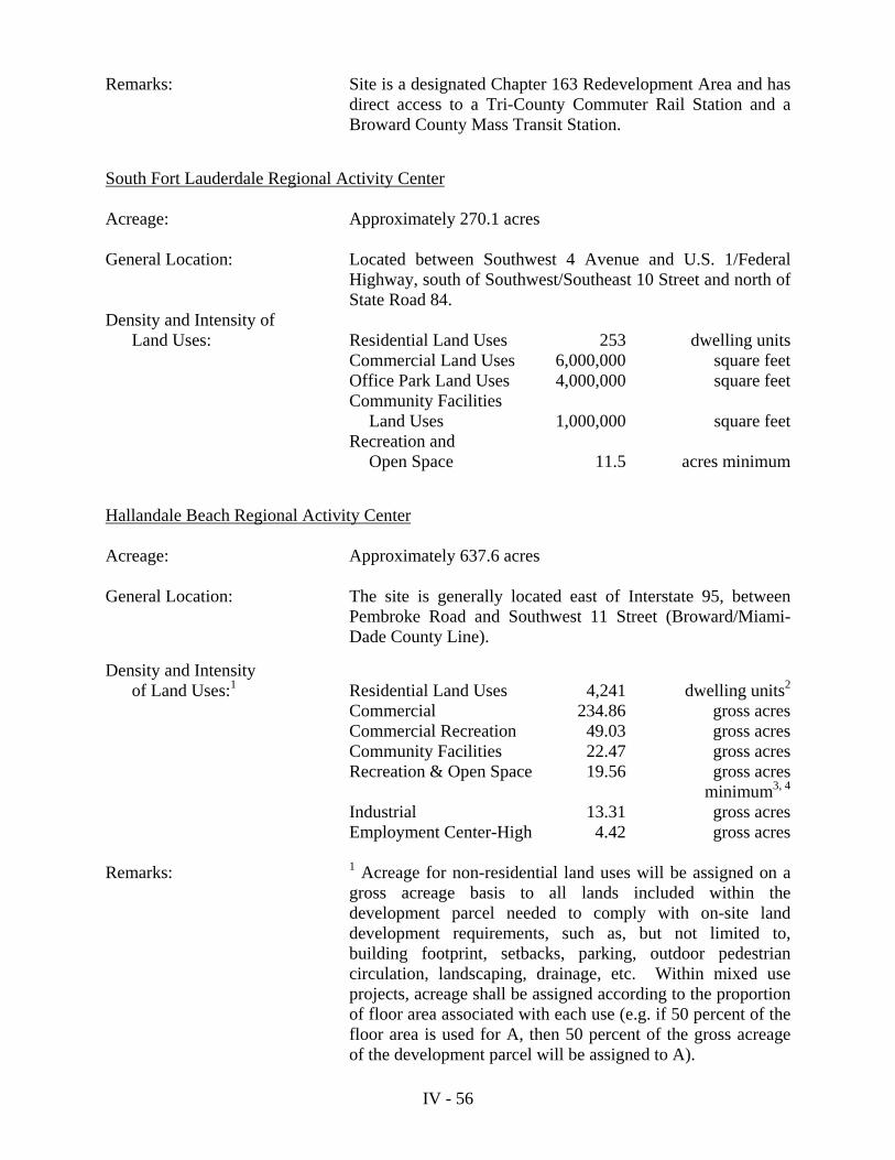
Remarks: Site is a designated Chapter 163 Redevelopment Area and has direct access to a Tri-County Commuter Rail Station and a Broward County Mass Transit Station.
South Fort Lauderdale Regional Activity Center Acreage: Approximately 270.1 acres General Location: Located between Southwest 4 Avenue and U.S. 1/Federal
Highway, south of Southwest/Southeast 10 Street and north of State Road 84.
Density and Intensity of Land Uses: Residential Land Uses 253 dwelling units Commercial Land Uses 6,000,000 square feet Office Park Land Uses 4,000,000 square feet Community Facilities Land Uses 1,000,000 square feet Recreation and Open Space 11.5 acres minimum
Hallandale Beach Regional Activity Center Acreage: Approximately 637.6 acres General Location: The site is generally located east of Interstate 95, between
Pembroke Road and Southwest 11 Street (Broward/Miami-Dade County Line).
Density and Intensity of Land Uses:1 Residential Land Uses 4,241 dwelling units2
Commercial 234.86 gross acres Commercial Recreation 49.03 gross acres Community Facilities 22.47 gross acres Recreation & Open Space 19.56 gross acres minimum3, 4 Industrial 13.31 gross acres Employment Center-High 4.42 gross acres Remarks: 1 Acreage for non-residential land uses will be assigned on a
gross acreage basis to all lands included within the development parcel needed to comply with on-site land development requirements, such as, but not limited to, building footprint, setbacks, parking, outdoor pedestrian circulation, landscaping, drainage, etc. Within mixed use projects, acreage shall be assigned according to the proportion of floor area associated with each use (e.g. if 50 percent of the floor area is used for A, then 50 percent of the gross acreage of the development parcel will be assigned to A).
IV - 57
2 Consisting of 550 single-family units, 491 duplexes, 1,200
townhomes, 1,000 garden apartments, and 1,000 mid-rise apartments. Dwelling units from any given category (ex: single-family, townhomes, etc.) may be substituted for dwelling units of another category provided that the substitution results in the same or lesser student generation using the County’s adopted student generation rates. Residential development east of U.S. 1 shall be limited to the number of units currently permitted by the Broward County Land Use Plan.
3 Resolution 2009-09 (adopted May 6, 2009) of the City of
Hallandale Beach dedicates Foster Park to the public for twenty-five (25) years as an outdoor recreation area because funding was provided through the Florida Recreation Development Assistance program (FDRAP). Additionally, if any other existing park acreage in the RAC is replaced, such replacement lands and facilities shall serve the same neighborhoods in an equivalent or improved capacity.
4 Park acreage includes the 0.4175 acres of the Foster Park
Addition. Acquisition of the site was accommodated through the Broward County Safe Parks and Land Preservation Bond Program.
Downtown Hollywood Regional Activity Center Acreage: Approximately 1,486 acres General Location: Generally located south of Sheridan Street, east of Interstate
95, west of South 17 Avenue and north of Pembroke Road. Density and Intensity of Land Uses: Residential Land Uses 15,100 dwelling units Commercial Land Uses 3,280,000 square feet Office Land Uses 1,500,000 square feet Community Facilities 390,000 square feet Open Space/Recreation 47.3 acres
(The referenced Open Space/Recreation uses shall preserve those open space and recreation land uses existing within the RAC designated area at the time of the effective date of Broward County Land Use Plan amendment PC 05-1/PCT 05-1: September 6, 2005).
IV - 58
The Office and Commercial intensities listed above shall be convertible from Office to Commercial (or vice versa) based on equivalence of traffic impacts (peak hour) as calculated by the current edition of the ITE Traffic Generation Manual. Conversions from Office to Commercial (or vice versa) shall be implemented administratively by the City, and shall be reported at least annually to the Broward County Planning Council as part of the City’s RAC monitoring obligations. The total number of PM peak hour trips generated (as calculated by the current edition of the ITE Traffic Generation Manual) will not exceed 8,026 peak hour trips. The City shall within one year adopt land development regulations that shall protect residential areas. These land development regulations will require City Commission approval of any development proposals on residentially zoned lands located inside the RAC area which seeks either: (i) To increase residential density above that permitted under
the applicable property’s zoned density; or
(ii) To introduce a non-residential use into a residentially zoned area.
The purpose and intent of these land development regulations shall be to protect established residential neighborhoods adjacent to the RAC area, while allowing appropriate redevelopment to take place.
Development within the RAC designated area shall conform to the City’s City-Wide Master Plan, as adopted into this Comprehensive Plan. The City shall complete the studies which are intended to yield further design guidelines for the Hollywood Boulevard, US 1 and Dixie Highway corridors within the RAC designated area. The City shall implement the design studies’ recommendations, as appropriate, through either land use plan amendments, amendments to land development regulations, or both.
Miramar Regional Activity Center Acreage: Approximately 2,205 acres General Location: North of Bass Creek Road between Palm Avenue and
Flamingo Road.

IV - 59
Density and Intensity of Land Uses: Residential Land Uses 7,460 dwelling units Retail Land Uses 1,836,400 square feet
Office Land Uses 1,500,000 square feet Industrial Land Uses 11,500,000 square feet Municipal Facility Land Uses 200,000 square feet
Remarks: This area is the subject of an Areawide Development of
Regional Impact. Arvida/Pompano Park North Regional Activity Center Acreage: Approximately 169.0 acres General Location: South of Atlantic Boulevard between Powerline Road and the
Seaboard Coastline Railroad. The Pompano Park North Regional Activity Center consists of that portion of the Arvida/Pompano Park Development of Regional Impact (DRI) located north of Race Track Road. The RAC is located south of Atlantic Boulevard and north of Race Track Road, between Powerline Road and the CSX Railroad and comprises approximately 169 gross acres. The area encompassed by the RAC must be zoned in a mixed zoning district that limits the density and intensity of land uses to the following: Density and Intensity of Land Uses: Office Land Uses 248,867 square feet Industrial Land Uses 1,013,250 square feet Commercial Land Uses 301,273 square feet Pompano Park South Regional Activity Center Acreage: Approximately 230.0 acres General Location: Located on the east side of Powerline Road, between
Southwest 3 Street and North Cypress Bend Drive. The Pompano Park South Regional Activity Center consisting of the Pompano Park racetrack, casino, and adjacent property. The RAC is located south of Race Track Road, between Powerline Road and the CSX Railroad, and comprises approximately 230 gross acres. The area encompassed by the RAC must be zoned in a mixed-use zoning district that limits the density and intensity of the land uses to the following:

IV - 60
Density and Intensity of Land Uses*: Residential 43 acres consisting of: 1,050 mid-rise apartment units 250 garden apartment units Commercial Recreation Land Uses 135 acres Commercial Land Uses 27 acres Office Land Uses 26 acres
*The Residential uses will consist of stand-alone residential as well as residential units as part of a mixed-use Commercial and Office development within the Commercial and Office designations. Residential units types may be re-allocated subject to a voluntary mitigation agreement with the Broward County School Board in the event of inadequate student capacity, and provided that the total number of residential units shall remain at 1,300. Acreage for non-residential land uses will be assigned on a gross acreage basis to all lands included within the development parcel needed to comply with on-site land development requirements, such as, but not limited to, building footprint, setbacks, parking, outdoor pedestrian circulation, landscaping, drainage, etc. Within mixed use projects, acreage shall be assigned according to the proportion of floor area associated with each use (e.g. if 50 percent of the floor area is used for A, then 50 percent of the gross acreage of the development parcel will be assigned to A). RESIDENTIAL USE The areas designated for residential use on the Future Broward County Land Use Map (Series), consistent with Objective 1.01.00, are intended primarily for dwellings, but other land uses related to a residential environment, including neighborhood shopping centers, neighborhood parks and schools may also be appropriate therein. Uses permitted in areas designated residential are as follows:
1. Dwelling units, subject to the density limits for a parcel as designated on the Future Broward County Land Use Plan Map (Series) or certified local land use plan map and as explained in the following subsection entitled “Residential Density.”
2. Home occupations and other uses accessory to a dwelling unit. 3. Hotels, motels and similar lodging. The maximum number of hotel, motel or
similar lodging units permitted on any parcel designated for residential use is double the maximum number of dwelling units permitted by the land use plan map designation.

IV - 61
4. Parks, golf courses and other outdoor recreational facilities, and recreational, civic, or other cultural buildings ancillary to the primary outdoor recreational use of the site.
5. Community facilities designed to serve the residential area such as schools,
day care centers, churches, clinics, nursing homes, rehabilitation centers, governmental administration, police and fire protection facilities, libraries and civic centers.
6. Public utilities, including water and wastewater treatment plants, pumping
stations, power plant substations and transmission facilities and solid waste disposal and transfer stations, excluding landfills and electrical power plants.
7. Communication facilities.
8. Agriculture.
9. Offices and/or neighborhood retail sales of merchandise or services, subject
to the review and approval requirements of Policy 1.01.05, Policy 1.01.06 and Policy 13.01.10 and the following limitations and provisions:
a. No more than a total of five percent (5%) of the area designated for
residential use on the Future Broward County Land Use Plan Map (Series) within a flexibility zone may be used for offices and/or neighborhood retail sales of merchandise or services.
b. No added contiguous area used for offices and/or neighborhood
retail sales of merchandise or services may exceed ten (10) acres. For the purpose of this provision, contiguous is defined as: attached; located within 500 feet; or separated only by streets and highways, canals and rivers, or easements.
c. Regardless of the constraints of a. and b. above, space within
residential buildings in areas designated for Medium-High (25) Residential or High (50) Residential density may be used for offices and/or retail sales of merchandise or services, as long as no more than 50% of the floor area is used for said purposes.
d. Regardless of the constraints of a. and b. above, space within
residential buildings in areas designated for Medium (16) Residential density may be used for offices, as long as no more than 50% of the floor area is used for offices.
10. Recreational vehicle park sites in the Low-Medium (10), Medium (16),
Medium-High (25) and High (50) Residential density ranges. The maxi-mum number of recreational vehicle park sites permitted is:

IV - 62
a. Equal to the maximum number of dwelling units designated for that parcel on the land use plan map if the local land development regulations allow permanent location of recreational vehicles on the sites; or
b. Double the maximum number of dwelling units designated for that
parcel on the land use plan map if the local land development regulations prohibit permanent location of recreational vehicles on the sites.
11. Special Residential Facilities; subject to: meeting one of the Category
definitions as contained in the Special Residential Facilities Permitted Uses subsection of the Plan Implementation Requirements section of the Broward County Land Use Plan; meeting density provisions by Category type stated below; and the limitations as expressed by the certified land use plan map; and if applicable, the provisions regarding the use and allocation of reserve units, flexibility units or bonus sleeping rooms as contained in the “Administrative Rules Document: Broward County Land Use Plan.”
Density Provisions:
a. Special Residential Facility Category (1) development shall count as one (1) dwelling unit each.
b. Special Residential Facility Category (2) development shall
count as two (2) dwelling units each.
c. Special Residential Facility Category (3) development shall count as one (1) dwelling unit per every two (2) sleeping rooms regardless of the number of kitchens or baths.
Residential Density a. Density Standards
Residential areas are shown on the Future Broward County Land Use Map (Series) according to eight ranges of density:
- The Estate (1) Residential category permits up to one (1) dwelling unit
per gross acre.
- The Low (2) Residential category permits up to two (2) dwelling units per gross acre.
- The Low (3) Residential category permits up to three (3) dwelling units
per gross acre.

IV - 63
- The Low (5) Residential category permits up to five (5) dwelling units
per gross acre.
- The Low-Medium (10) Residential category permits up to ten (10) dwelling units per gross acre.
- The Medium (16) Residential category permits up to sixteen (16)
dwelling units per gross acre.
- The Medium-High (25) Residential category permits up to twenty-five (25) dwelling units per gross acre.
- The High (50) Residential category permits up to fifty (50) dwelling units
per gross acre. Other land use categories and land uses are subject to density standards as follows:
- Residential development within the Agricultural land use category is subject to the density standards and provisions contained within the Agricultural Permitted Uses subsection of the Plan Implementation Requirements section of this plan.
- Special Residential Facilities are subject to the density standards
contained within applicable land use categories in the Permitted Uses subsection of the Plan Implementation Requirements section of this plan.
- Recreational vehicle sites are subject to the density standards contained
within applicable land use categories in the Permitted Uses subsection of the Plan Implementation Requirements section of this plan.
- Hotels, motels and similar lodging are subject to the density standards
contained within applicable land use categories in the Permitted Uses subsection of the Plan Implementation Requirements section of this plan.
b. Density Calculation
All references to density within the Broward County Land Use Plan mean gross density. Gross density means the number of dwelling units existing or proposed within an area, divided by the gross acreage of the area. Gross acreage means the total number of acres in an area, including acreage used or proposed for streets, lakes, waterways, and other proposed land uses permitted in residential areas by the Broward County Land Use Plan. Any existing live-aboard vessels which conformed to the regulations in effect when such vessels were included within the definition of “dwelling unit,” that become nonconforming by the enactment of Text Amendment PCT 98-5 shall be removed or discontinued as a dwelling unit within five (5) years of the effective date of Text Amendment PCT 98-5. (Effective Date: September 7, 1998)

IV - 64
Calculations of acreage covered by different land use categories on the Future Broward County Land Use Plan Map (Series) will necessarily be approximate, due to the scale of the map. Where edges of land use categories are close to property lines, streets, transmission lines or other existing lines, edges should be construed to follow those lines. A lake or canal should be construed as having been assigned the same land use category as that assigned to adjacent unsubmerged land. The Intracoastal Waterway, North and South Lakes in Hollywood, Sylvan Lake, Lake Santa Barbara, New River, Middle River, and the rivers and canals of the primary drainage system as identified within this plan shall not, however, be construed as having credit toward residential density.
c. Arrangement of Dwelling Units
Any arrangement of dwelling units on a parcel of land designated for residential use is compatible with the Broward County Land Use Plan as long as the maximum number of dwelling units permitted within the parcel is not exceeded. For example, the Broward County Land Use Plan does not regulate whether a developer uses 100 acres of land designated for Low (5) Residential density to build 500 single family homes or whether the same 100 acres are used to build a 500 unit high-rise structure, with the balance of the land maintained as permanent open space. The distribution of units will be determined by local zoning and land development regulations.
d. Dashed-Line Areas
Selected Developments of Regional Impact, planned unit developments and partially completed large scale developments, are identified on the Future Broward County Land Use Plan Map (Series) by dashed lines circumscribing their edges. For each of these areas, the maximum overall density in dwelling units per acre is the number which appears in the circle inside the dashed line. That number can be multiplied by the number of acres inside the dashed line, including areas not designated for residential use, to ascertain the maximum number of dwelling units allowable within the dashed line. The dwelling units that are permitted within areas circumscribed by a dashed line may only be applied within the boundaries of the circumscribed area and may not be transferred. Additional dashed-line areas may be designated on the Future Broward County Land Use Plan Map (Series) through amendments to the plan consistent with the provisions of this section.
e. Flexibility Units
“Flexibility units” mean the difference between the number of dwelling units permitted within a flexibility zone by the Future Broward County Land Use Plan Map (Series) and the number of dwelling units permitted within the flexibility zone by a local government’s certified future land use plan map.
Since the certified local land use plan map may be more restrictive than the Future Broward County Land Use Plan Map (Series), available flexibility units may be utilized by a local government to rearrange residential densities consistent with Policy 1.02.01 and Policy 13.01.10.

IV - 65
Rearrangement of residential densities utilizing flexibility units will be administered within “flexibility zones.” The boundaries of and rules governing “flexibility zones” and rearrangement of residential densities therein, as referenced in Policy 1.02.02, will be established, subject to the provisions of Policy 13.01.10, within the “Administrative Rules Document: Broward County Land Use Plan.”
The maximum number of dwelling units permitted in a flexibility zone by the local land use plan map shall not exceed the number of dwelling units permitted in the flexibility zone by the Future Broward County Land Use Plan Map (Series). Allocations of Flexibility Units shall be subject to the following restrictions:
(1) Within areas east of the Intracoastal Waterway or west of the “urban infill” area
boundary line as designated on the Broward County Land Use Plan as of the effective date of this Policy (November 5, 2004), in no instance shall allocations of Flexibility Units result in a residential density greater than twenty five (25) dwelling units per gross acre for the residentially designated parcel or portion of a non-residentially designated parcel to be developed with residential use, or exceed one hundred percent (100%) of the maximum number of dwelling units indicated for the parcel by the local land use plan map, whichever resulting residential density is less.
(2) Allocations of Flexibility Units for “affordable housing,” special residential
facilities, and areas designated “Regional Activity Center” as defined within the Broward County Land Use Plan, regardless of the provisions referenced in 1. above, shall be exempt from this provision;
(3) This provision shall not apply to the action of a local government whereby
Flexibility Units were approved pursuant to the Broward County Land Use Plan and Administrative Rules prior to the effective date of this provision (November 5, 2004).
f. Reserve Units
“Reserve units” mean additional permitted dwelling units equal to two percent (2%) of the total number of dwelling units permitted within a flexibility zone by the Future Broward County Land Use Plan Map (Series).
Local governments may establish provisions within their land use plans, consistent with Policy 1.01.03 and Policy 13.01.10 of this Plan, to allocate residential densities, utilizing reserve units, which exceed those shown on the local land use plan map.
Allocation of reserve units will be administered within “flexibility zones” and not require amendment of the certified local land use plan. The boundaries of and rules governing “flexibility zones” and allocation of reserve units therein, as referenced in Policy 1.02.02, will be established, subject to the provisions of Policy 13.01.10, within the “Administrative Rules Document: Broward County Land Use Plan.”

IV - 66
The number of reserve units in a flexibility zone will be fixed at the adoption of the Future Broward County Land Use Plan Map (Series). Allocations of Reserve Units shall be subject to the following restrictions:
(1) Within areas east of the Intracoastal Waterway or west of the “urban infill” area
boundary line as designated on the Broward County Land Use Plan as of the effective date of this Policy (November 5, 2004), in no instance shall allocations of Reserve Units result in a residential density greater than twenty five (25) dwelling units per gross acre for the residentially designated parcel or portion of a non-residentially designated parcel to be developed with residential use, or exceed one hundred percent (100%) of the maximum number of dwelling units indicated for the parcel by the local land use plan map, whichever resulting residential density is less.
(2) Allocations of Reserve Units for “affordable housing,” special residential facilities
and areas designated “Regional Activity Center” as defined within the Broward County Land Use Plan, regardless of the provisions referenced in 1. above, shall be exempt from this provision.
(3) This provision shall not apply to the action of a local government whereby Reserve
Units were approved pursuant to the Broward County Land Use Plan and Administrative Rules prior to the effective date of this provision.
g. Redevelopment in Coastal High Hazard Area
Local certified land use plans may permit the redevelopment of residentially designated areas, including existing hotel uses, located within the coastal high hazard area which were subject to past decreases in density resulting from the adoption of the 1977 or 1989 Broward County Land Use Plan. Such redevelopment shall be limited to the actual built density/intensity (number of dwelling units and building square footage) and meet all public safety codes in effect at the time of redevelopment including building code, flood elevation and hurricane evacuation standards. Building square footage may be increased by one percent for every two percent reduction in the number of dwelling units subject to local land development regulations addressing building bulk, shadow and form. Local certified land use plans shall also comply with the natural resource protection policies addressing the protection of beaches, rivers and marine resources enumerated under Objective 9.03.00 of the Broward County Land Use Plan.
RURAL ESTATES Areas are designated Rural Estates on the Future Broward County Land Use Plan Map (Series) consistent with Objective 7.01.00 to protect the semi-rural character and lifestyle of existing low density residential estate areas. Rural estate areas are characterized by residential estates, horse ranches and related agricultural uses. The maximum permitted density within this category is one unit per acre. Limited community facility and utility uses are permitted for the purposes of serving the rural estate communities. Application of flexibility/reserve units and commercial flexibility is not permitted within areas designated Rural Estates.
IV - 67
Uses permitted in areas designated Rural Estates are as follows:
1. Dwelling units at a maximum of one unit per gross acre with no clustering permitted.
2. Home occupations and other uses accessory to a dwelling unit.
3. Open space and recreation uses designed to serve the residential area.
4. Community facilities designed to serve the residential area limited to schools,
day care centers, churches, clinics, governmental administration, police and fire protection facilities, libraries and civic centers not to exceed five acres in size. Notwithstanding the aforesaid, public schools shall not be subject to the five (5) acre restriction.
5. Public utilities limited to water and wastewater treatment plants, pumping
stations, telecommunications facilities, electrical substations and transmission lines and drainage facilities and structures.
6. Agricultural uses including cultivation of crops, groves, thoroughbred and
pleasure horse ranches, private game preserves, fish breeding areas, tree and plant nurseries, cattle ranches and similar activities.
7. Cemeteries.
RURAL RANCHES Areas are designated Rural Ranches on the Future Broward County Land Use Plan Map (Series) consistent with Objective 7.01.00 to protect the semi-rural character and lifestyle of existing low density rural ranch areas. Rural ranch areas are characterized by residential estates, horse ranches and related agricultural uses. The maximum permitted density within this category is one unit per two and one-half gross acres or one unit per two net acres. Limited community facility and utility uses are permitted for the purposes of serving the rural ranch communities. Application of flexibility/reserve units and commercial flexibility is not permitted within areas designated Rural Ranches. Uses permitted in areas designated Rural Ranches are as follows:
1. A maximum of one unit per two and one-half gross acres or one unit per two net acres with no clustering permitted.
2. Home occupations and other uses accessory to a dwelling unit.
3. Open space and recreation uses designed to serve the residential area.

IV - 68
4. Community facilities designed to serve the residential area limited to schools, day
care centers, churches, clinics, governmental administration, police and fire protection facilities, libraries and civic centers not to exceed five acres in size. Notwithstanding the aforesaid, public schools shall not be subject to the five (5) acre restriction.
5. Public utilities limited to water and wastewater treatment plants, pumping stations,
telecommunications facilities, electrical substations and electric lines and drainage facilities and structures.
6. Agricultural uses including cultivation of crops, groves, thoroughbred and pleasure
horse ranches, private game preserves, fish breeding areas, tree and plant nurseries, cattle ranches and similar activities.
7. Cemeteries.
TRANSIT ORIENTED CORRIDOR The following areas have been designated Transit Oriented Corridors within the Broward County Land Use Plan: Davie Transit Oriented Corridor Acreage: Approximately 903.7 acres General Location: South side of Interstate 595 between State Road 7/U.S. 441 and
Florida’s Turnpike. Density and Intensity of Land Uses:
Residential Land Uses 6,428 dwelling units*Industrial/Flex Land Uses 3,600,000 square feetOffice Land Uses 1,700,000 square feetCommercial Land Uses 600,000 square feetHotel 750 roomsOpen Space 120 acres minimum**
Remarks: *Consisting of 1,800 high-rise dwelling units, 2,650 mid-rise
dwelling units, 1,250 garden apartments and 500 townhouse dwelling units (228 mobile homes currently exist).
At least 15 percent of the residential units shall be provided as
affordable as defined in Article 8 of the Broward County Land Use Plan, and the affordability of the units shall be maintained for a period of 15 years. No development plan for this project shall be approved unless a declaration of restrictive covenants, a plat note or other form of enforceable restriction acceptable to the City is included therein which provides assurance that this affordable housing requirement will be met.
IV - 69
**Open space shall include but not be limited to parks and open
space, stormwater retention ponds, drainage easements, landscaped areas and other pervious areas fulfilling the goal of water recharge into the aquifer.
Downtown Pompano Transit Oriented Corridor (DP-TOC) Acreage: Approximately 272.8 acres General Location: Generally bound on the north by Northwest 6 Street/Northwest 6
Court, on the south by Atlantic Boulevard/Southwest 2 Street, on the east by Northeast 5 Avenue, and on the west by Northwest 10 Avenue.
Density and Intensity of Land Uses: Residential Land Uses 1,368 dwelling units* Commercial Land Uses 4,387,220 square feet Office Land Uses 2,835,557 square feet Community Facilities 1,459,260 square feet Utilities 95,832 square feet Hotel 300 rooms Recreation and Open Space 2.1 acres (minimum)** *Consisting of 143 single-family dwelling units, 236 townhomes and
989 multi-family dwelling units. **If any existing park acreage in the TOC is replaced, such
replacement lands and facilities shall serve the same neighborhoods in an equivalent or improved capacity.
Design principles and procedures will apply to all development and
redevelopment within the boundaries of the proposed DP-TOC, as follows:
Guiding Design Principles and Procedures: All Applicants with development proposals in the DP-TOC will be
required to attend a mandatory pre-design workshop with the CRA and City Urban Designers prior to Site Plan or Master Plan submittal for official review. Ensuring compatibility with adjacent properties in regard to both zoning designation and existing development will be the focus of the preliminary design meeting. In all cases, the best approach to respecting and designing for the existing context and optimizing compatibility with adjacent properties will be identified. Guiding principles will include specific focus on the following:
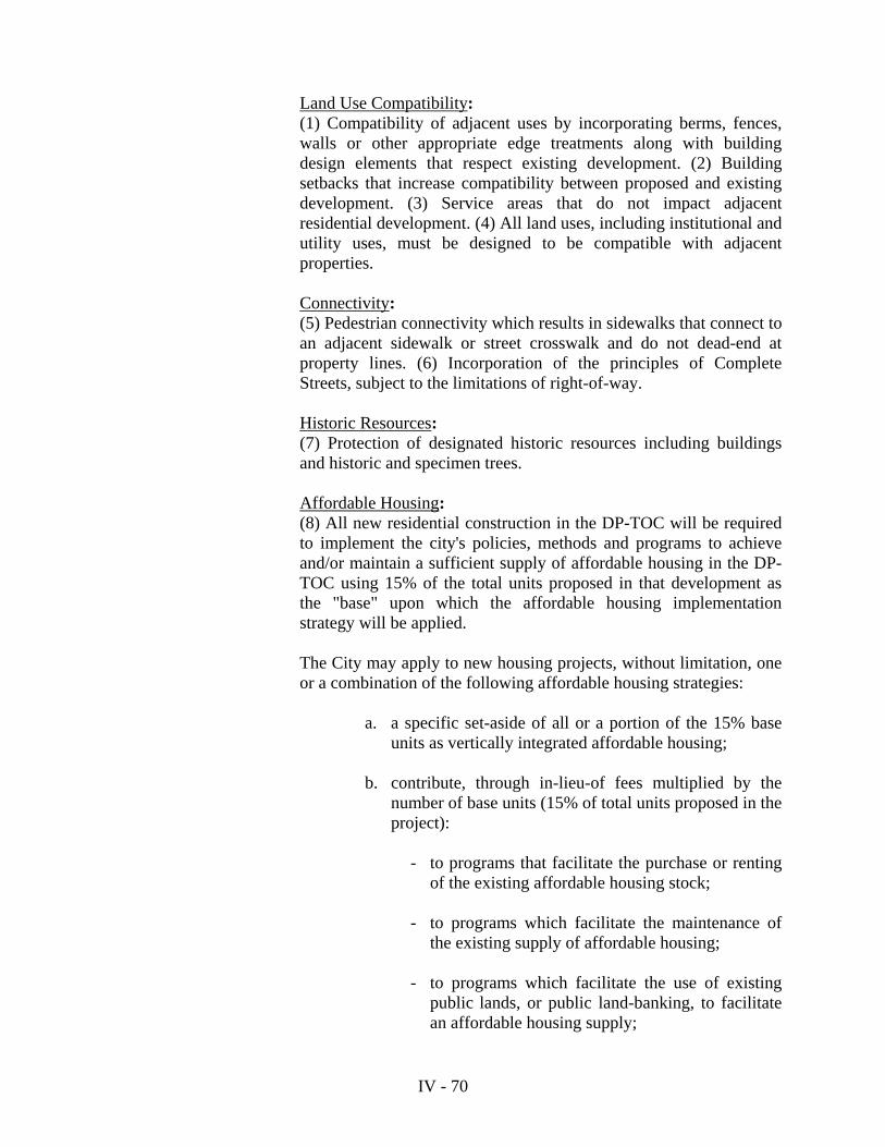
IV - 70
Land Use Compatibility: (1) Compatibility of adjacent uses by incorporating berms, fences,
walls or other appropriate edge treatments along with building design elements that respect existing development. (2) Building setbacks that increase compatibility between proposed and existing development. (3) Service areas that do not impact adjacent residential development. (4) All land uses, including institutional and utility uses, must be designed to be compatible with adjacent properties.
Connectivity: (5) Pedestrian connectivity which results in sidewalks that connect to
an adjacent sidewalk or street crosswalk and do not dead-end at property lines. (6) Incorporation of the principles of Complete Streets, subject to the limitations of right-of-way.
Historic Resources: (7) Protection of designated historic resources including buildings
and historic and specimen trees. Affordable Housing: (8) All new residential construction in the DP-TOC will be required
to implement the city's policies, methods and programs to achieve and/or maintain a sufficient supply of affordable housing in the DP-TOC using 15% of the total units proposed in that development as the "base" upon which the affordable housing implementation strategy will be applied.
The City may apply to new housing projects, without limitation, one
or a combination of the following affordable housing strategies: a. a specific set-aside of all or a portion of the 15% base
units as vertically integrated affordable housing; b. contribute, through in-lieu-of fees multiplied by the
number of base units (15% of total units proposed in the project):
- to programs that facilitate the purchase or renting of the existing affordable housing stock;
- to programs which facilitate the maintenance of
the existing supply of affordable housing; - to programs which facilitate the use of existing
public lands, or public land-banking, to facilitate an affordable housing supply;

IV - 71
- to other programs or initiatives designed and
implemented by the city to address specific affordable housing market needs and challenges in the DP-TOC that may arise including but not limited to, strategies that reduce the cost of housing production; promote affordable housing development; prevent displacement; and promote transit amongst low income populations.
Hollywood State Road 7/U.S. 441 Transit Oriented Corridor Acreage: Approximately 980.3 acres General Location: Located along both sides of State Road 7/U.S. 441 between the
northern and southern City of Hollywood boundaries. Density and Intensity of Land Uses: Commercial 15,000,000 square feet Office 2,000,000 square feet Community Facilities 1,000,000 square feet Industrial 1,000,000 square feet Hotel 2,500 rooms Residential* 5,309 dwelling units consisting of: 2,400 single family homes,
2,400 townhomes and 509 garden apartments.
*Dwelling units from any given category (ex: single family,
townhomes, etc.) may be substituted for dwelling units of another category provided that the substitution results in the same or lesser student generation using the County’s adopted student generation rates. No new residential development shall be constructed in the TOC within the 60+ Ldn contour located north of Griffin Road.
Lauderhill State Road 7/U.S. 441 Transit Oriented Corridor Acreage: Approximately 483.7 acres
General Location: West of State Road 7/U.S. 441 between Northwest 29 Avenue and Sunrise Boulevard and east of State Road 7/U.S. 441 between Northwest 19 Street and Sunrise Boulevard.

IV - 72
Density and Intensity of Land Uses:
Residential Land Uses 6,262 dwelling unitsCommercial Land Uses 5,229,208 square feetIndustrial Land Uses 1,491,908 square feetRecreation and Open Space 128.8 acres minimum
Margate Transit Oriented Corridor Acreage: Approximately 1,184.3 acres
General Location: South of Sample Road and approximately ½ mile north of Cypress Creek Road, bisected by State Road 7/U.S. 441.
Miramar Transit Oriented Corridor Acreage: Approximately 439.7 acres General Location: Located east of Southwest 66 Avenue and bound on the north by
Pembroke Road, on the east by State Road 7/U.S. 441, and on the south by County Line Road.
Density and Intensity of Land Uses:
Residential Land Uses 3,406 dwelling units*Office Land Uses 2,500,000 square feetCommercial Land Uses 2,500,000 square feetHotel 250 roomsParks 61.31 acres minimum**
Density and Intensity of Land Uses:
Commercial Land Uses 4,454,894 square feetIndustrial Land Uses 1,830,884 square feetOffice Land Uses 1,371,159 square feetResidential Land Uses 3,565 dwelling units*Hotel 555 roomsRecreation and Open Space 35 acres (minimum)
Remarks:
*At least 15 percent (277 dwelling units) of the 1,849 additional, unbuilt residential units shall be provided as affordable as defined in Article 8 of the Broward County Land Use Plan, and the affordability of the units shall be maintained for the period of time required in such article. No development plan for this project shall be approved unless a declaration of restrictive covenants, a plat note or other form of enforceable restriction acceptable to the City is included therein which provides assurance that this affordable housing requirement will be met.

IV - 73
West Park State Road 7/U.S. 441 Transit Oriented Corridor Acreage: Approximately 88.0 acres General Location: East of State Road 7/U.S. 441 between Pembroke Road and Southwest
41 Street (the Broward/Miami-Dade County Line).
Density and Intensity of Land Uses:
Residential Land Uses 1,500 dwelling units*Commercial Land Uses 500,000 square feetOffice Land Uses 575,000 square feetHotel 200 rooms
Remarks: *Consisting of 1,000 high-rise† dwelling units, 450 garden apartment
dwelling units and 50 townhouse dwelling units. Wilton Manors Transit Oriented Corridor Acreage: Approximately 114.2 acres General Location: Generally located between Northeast 11 Avenue and Northeast 15/16
Avenue, and between the South Fork of the Middle River and the North Fork of the Middle River.
Density and Intensity of Land Uses: Residential Land Uses 519 dwelling units* Hotel 172 rooms Commercial Land Uses 538,200 square feet Industrial Land Uses 71,600 square feet Transportation 7.8 acres Recreation and Open Space 6.9 acres (minimum)* † Note: High-rise units are defined as four (4) stories or more, consistent with the effective Broward County Land Development Code definition at the time of the adoption of the Broward County Land Use Plan amendment.
Remarks: *Consisting of 1,883 mid-rise units, 659 (3-bedroom) townhouse units, 623 single-family units, 209 (2-bedroom) garden apartment units, and 32 mobile homes. **Park acreage includes Snake Warrior’s Island Park (55 acres), Miramar Athletic Park (5.71 acres), and the City’s proposed Miramar Athletic Park Addition (0.6 acres). Acquisition of the Miramar Athletic Park Addition site was accommodated through the Broward County Safe Parks and Land Preservation Bond Program.
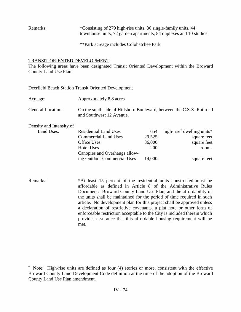
IV - 74
Remarks: *Consisting of 279 high-rise units, 30 single-family units, 44
townhouse units, 72 garden apartments, 84 duplexes and 10 studios. **Park acreage includes Colohatchee Park. TRANSIT ORIENTED DEVELOPMENT The following areas have been designated Transit Oriented Development within the Broward County Land Use Plan: Deerfield Beach Station Transit Oriented Development
Acreage: Approximately 8.8 acres General Location: On the south side of Hillsboro Boulevard, between the C.S.X. Railroad
and Southwest 12 Avenue.
Density and Intensity of Land Uses:
Residential Land Uses
654
high-rise† dwelling units*
Commercial Land Uses 29,525 square feetOffice Uses 36,000 square feetHotel Uses 200 roomsCanopies and Overhangs allow-ing Outdoor Commercial Uses
14,000
square feet
† Note: High-rise units are defined as four (4) stories or more, consistent with the effective Broward County Land Development Code definition at the time of the adoption of the Broward County Land Use Plan amendment.
Remarks:
*At least 15 percent of the residential units constructed must be affordable as defined in Article 8 of the Administrative Rules Document: Broward County Land Use Plan, and the affordability of the units shall be maintained for the period of time required in such article. No development plan for this project shall be approved unless a declaration of restrictive covenants, a plat note or other form of enforceable restriction acceptable to the City is included therein which provides assurance that this affordable housing requirement will be met.

IV - 75
Hollywood Transit Oriented Development
Acreage: Approximately 40.4 acres General Location: East side of the C.S.X. Railroad, between Sheridan Street and Taft
Street.
Remarks:
At least 20% of the total dwelling units (210 dwelling units) must be “workforce-income” affordable housing as defined in Section 420.5095, Florida Statutes, for those persons having a total anticipated income for the household that is not more than 140% of the area median income, adjusted for household size.
† Note: High-rise units are defined as four (4) stories or more, consistent with the effective Broward County Land Development Code definition at the time of the adoption of the Broward County Land Use Plan amendment.
Density and Intensity of Land Uses:
Commercial Land Uses 300,000 square feetOffice Land Uses 299,000 square feetHigh-rise† Residential Land Uses 550 dwelling unitsMulti-Family Residential Land Uses 500 dwelling unitsHotel 150 roomsTransportation Uses (Parking for Tri-Rail Station) 280,000 square feet 793 spaces (minimum)
Notes:
1. Sheridan Stationside Village is directly served by a Tri-Rail Station.
2. Pursuant to Agreement between Stationside Village Associates and FDOT, 793 parking spaces are obligated for the Tri-Rail Station.
3. The non-residential FAR is 0.218.
4. Prior to the issuance of building permits for more than 500 residential units, a minimum of 100,000 square feet of commercial (retail and/or office) square footage must be under construction.
5. Public park/Oak Hammock: Minimum 6 acres.

IV - 76
Sunrise Transit Oriented Development (Metropica) Acreage: Approximately 92.2 acres General Location: North side of Sunrise Boulevard, along both sides of Northwest 136
Avenue.
TRANSPORTATION USE Existing airports, Port Everglades, and existing and proposed expressways are designated transportation on the Future Broward County Land Use Plan Map (Series) consistent with Objective 12.03.00. Those uses permitted in areas designated transportation are as follows: Port Everglades Transportation Area Shipping, warehousing and, with the exception of residential uses, all other uses which may be permitted by the Broward County Board of County Commissioners which are consistent with tourism, international trade, and maritime commerce. Air Transportation Areas Airports and related facilities designed primarily to serve the needs of airport users and airport employees, airport and aircraft operation and maintenance facilities, cargo distribution terminals, transit warehousing, other compatible uses, and those land uses, except permanent residences, permitted in the recreation and open space, commercial recreation and agricultural land use categories. Expressways Uses of an impermanent nature such as agriculture, nurseries, grazing, non-required parking, open storage and parks are permitted in proposed expressways. Such provisions are intended to provide owners of property within proposed expressways with limited uses that do not interfere with the long term public goal of acquiring rights-of-way for expressway purposes. No principal building may be permitted, nor may any land use which impedes the future construction of an expressway be allowed. Proposed expressways shall have an underlying residential land use designation unless bordered on both sides by non-residential land use designations. The underlying density credited to the expressway shall be equal to the density of the adjacent residential land use designation. In cases where the proposed expressway is bordered by residential land use designations of different densities, the adjacent density shall apply up to the mid-point of the right-of-way. Residential units may not be constructed within the proposed expressway. However, the densities accruing to the proposed expressway may be transferred to adjacent parcels if the owner dedicates the right-of-way to a governmental agency for expressway uses.
Density and Intensity of Land Uses:
Commercial Land Uses 485,000 square feetOffice Land Uses 785,000 square feetHigh-Rise† Residential Land Uses 2,500 dwelling unitsTownhouse Residential Land Uses 300 dwelling units

IV - 77
If a formal determination has been made by the Broward County Board of County Commissioners that the proposed expressway will not be constructed, the land uses permitted within the expressway corridor shall be those permitted by the adjacent land use designation as determined by the appropriate local government through the Planning Council (re)certification process. UTILITIES USE Utilities are designated on the Future Broward County Land Use Plan Map (Series), consistent with Objective 8.05.00, to ensure the availability of land necessary to provide an adequate level of utility service to meet the current and future needs of Broward County. Utilities are also allowed in areas designated residential, commercial, office park, industrial, employment center, regional activity center and agricultural. Uses permitted in the areas designated utilities are as follows: 1. Utilities such as water and wastewater treatment plants, pumping stations,
electrical substations, solid waste disposal and transfer stations, excluding electrical power plants.
2. Other uses determined to be ancillary to the primary uses described in (1).
The following uses may also be permitted in the areas designated utilities as long as the location of these uses does not preclude or adversely affect the future use of the surrounding areas for utility facilities:
3. Recreation and open space uses. 4. Non-residential Agricultural uses. 5. Communication facilities.

IV - 78
B. 2. COMMUNICATION FACILITIES Communication facilities such as television and radio stations and relay structures and telephone facilities are not specifically designated on the Future Broward County Land Use Plan Map (Series) as a separate category. Such facilities may be permitted in areas designated under the following categories: 1. Residential 2. Commercial 3. Industrial 4. Office Park 5. Employment Center 6. Agricultural 7. Regional Activity Center 8. Utilities 9. Rural Estates and Rural Ranches 10. Mining B. 3. SPECIAL RESIDENTIAL FACILITIES The Broward County Land Use Plan defines categories of Special Residential Facilities, in accordance with Broward County Ordinance 85-92, for the purpose of determining permitted locations and density standards. Special Residential Facilities development such as group homes and foster care facilities are defined by category type below and are subject, when applicable, to the Special Residential Facilities provisions and allocation of reserve, flexibility, or bonus sleeping rooms as contained in the “Administrative Rules Document: Broward County Land Use Plan.” In order to facilitate implementation of this section, each local government may permit a maximum of one hundred (100) “bonus” sleeping rooms, consistent with Broward County Ordinance 85-92, that are permanently dedicated to Special Residential use without allocating density. Special residential facilities are not specifically designated on the Future Broward County Land Use Plan Map (Series) as a separate land use category. Special residential facilities are permitted within limitations as stated in the Permitted Uses section of this plan in the following land use categories: 1. Residential 2. Commercial 3. Office Park 4. Agricultural 5. Community Facilities Broward County does not encourage local governments to locate special residential facilities in commercial, office park or community facilities areas. Special residential facilities should be integrated into residential neighborhoods. However, due to the need to locate special residential facilities, the Broward County Land Use Plan recognizes that, in some instances, local governments may have need to allocate special residential facilities in these areas.

IV - 79
Definitions of Special Residential Facilities Categories: SPECIAL RESIDENTIAL FACILITY, CATEGORY (1) - means a housing facility which is licensed by the State of Florida for no more than eight (8) individuals who require treatment, care, rehabilitation or education. The facility is usually referred to as a group home. This includes individuals who are elderly, dependent children, physically disabled, developmentally disabled or individuals not overtly of harm to themselves or others. The facility provides a family living environment including supervision and care necessary to meet the physical, emotional and social needs of the individuals. It may or may not provide education or training. There may be more than one kitchen within the housing facility. There may be more than one Special Residential Facility Category (1) development on a parcel. SPECIAL RESIDENTIAL FACILITY, CATEGORY (2) - means a housing facility which is licensed by the State of Florida for nine (9) to sixteen (16) non-elderly individuals who require treatment, care, rehabilitation or education. This includes individuals who are dependent children, physically disabled, developmentally disabled or individuals not overtly of harm to themselves or others. The facility provides a family living environment including supervision and care necessary to meet the physical, emotional and social needs of the individuals. It may or may not provide education or training. There may be more than one kitchen within the housing facility. There may be more than one Special Residential Facility Category (2) development on a parcel. SPECIAL RESIDENTIAL FACILITY, CATEGORY (3) – means
(a) Any housing facility licensed by the State of Florida for more than sixteen (16) non-elderly individuals who require treatment, care, rehabilitation or education. This includes individuals who are dependent children, physically disabled, develop-mentally disabled or individuals not overtly of harm to themselves or others; or
(b) Any housing facility licensed by the State of Florida for more than eight (8) unrelated
elderly individuals; or
(c) Governmentally subsidized housing facilities entirely devoted to care of the elderly, dependent children, the physically handicapped, developmentally disabled or individuals not overtly of harm to themselves or others; or
(d) Any not-for-profit housing facility for unrelated elderly individuals; or
(e) Any housing facility which provides a life-care environment. A life-care environ-
ment shall include, but is not limited to, creation of a life estate in the facility itself and provision of off-site or on-site medical care.


![Zoning Districts, Land Uses, and Development Standards24-13 AGRICULTURE ZONES 16 TABLE 24-13-1 PERMITTED LAND USES IN THE AGRICULTURE ZONES [1] [2] Key P Permitted use, subject to](https://static.fdocuments.net/doc/165x107/5eda1fbdb3745412b570cec1/zoning-districts-land-uses-and-development-standards-24-13-agriculture-zones-16.jpg)
