Ayn el-Mraysseh, A Shrinking Space of Public Practices and Social Relation
7
Ayn el-Mraysseh, A Shrinking Space of Public Practices and Social Relations Antoine Atallah Department of Architecture and Design AUB [email protected] I. INTRODUCTION This paper documents and analyzes the ways in which groups of urban dwellers negotiate their presence in the city on the basis of particular images or memories of spaces that they nurture and try to preserve in their practice of their neighbor- hood. It takes as a case study the area of Ayn el-Mraysseh, a sector of Municipal Beirut’s northern coast which can be roughly defined from the Eastern edge of the AUB to the Ayn el-Mraysseh Mosque and from the Corniche road to Clemen- ceau Street, with particular emphasis on the coastal area. Fieldwork for this paper was conducted between April and June 2009. Ayn el-Mraysseh went through a long process of transformation which ultimately led, from the 70’s onwards, to the gradual loss of much of its social dynamism and sea- oriented culture. The demographics of the area changed, as many of its original inhabitants left which severed deeply rooted social relations. The public social practices spreading along the coast were greatly reduced, as the space where they took place shrunk, the locus of different activities being de- stroyed, abandoned or transformed drastically by the newco- mers to the neighborhood. In this process, real estate develop- ment played an important role in changing the area’s environ- mental characteristics and displacing more of its inhabitants. My aim in this paper is to study how these changes in the built environment and shifts of demographics have affected the practices and social relations of its inhabitants. I will ap- proach Ayn el-Mraysseh as a space of memory and attachment to a lost golden age, where a number of people who consider themselves the original inhabitants of the area strive to keep old practices and relations in an ever shrinking set of spaces and social networks. Equally important is how most of these inhabitants choose to inscribe themselves in the future of the area, and the ways they adapt, resist or follow the development trend that is dominant around them. II. SCOPE AND METHODOLOGY My research dealt extensively with the memory and opinions of people. I needed to have extensive personal contact with the people of the area and relied on interviews as the main medium through which I collected the research material. In the course of open discussions, a number of respondents were asked to draw a mental map of Ayn el-Mraysseh as they re- membered it. Their illustrations revealed places of significance for each individual as spaces of certain practices, to be com- pared with the current functioning of the neighborhood. My area of research was originally centered on the residential quarters to the south of Ayn el-Mraysseh. The an- swers of my respondents however led me to re-center my re- search around the coastal area of the neighborhood, along the Dar el-Mraysseh Street as it is there that most spaces of prac- tices turned out to be located. Since my work considers Ayn el-Mraysseh as a place of memory, the time frame in which I worked is important to define. The “old” Ayn el-Mraysseh the inhabitants keep refer- ring to lies before 1974, the year of the final extension of the Corniche which cut most of the neighborhood from its privi- leged access to the sea [2]. This ushered the decline of the neighborhood along with the advent of the civil war (1975) the year after, which caused the emigration of a large part of its inhabitants, and brought in many war refugees and the rule of militias [3]. A second accelerated phase of decline came after the war, in the1990’s when Ayn el-Mraysseh became prime land for high-end developments, which destroyed even more of the old fabric and forced the immigration of more of its inhabi- tants. Thus, the old Ayn el-Mraysseh refers to the pre-1974 period of its “golden age”, seen in contrast to the period of sig- nificant transformations extending from1974 to date. My study sample is constituted of a group of people who consider themselves the original inhabitants of Ayn el- Mraysseh. These “ahl el mantaka” the “people of the region” as they call themselves, constitute a group with loosely defined boundaries. According to some, it is constituted of families that have settled in the area since the 19 th century while for others,
-
Upload
antoine-atallah -
Category
Documents
-
view
218 -
download
0
description
Paper published for the FEA Student Conference
Transcript of Ayn el-Mraysseh, A Shrinking Space of Public Practices and Social Relation
Ayn el-Mraysseh, A Shrinking Space of Public
Practices and Social Relations
Antoine Atallah Department of Architecture and Design
AUB
I. INTRODUCTION
This paper documents and analyzes the ways in which
groups of urban dwellers negotiate their presence in the city on
the basis of particular images or memories of spaces that they
nurture and try to preserve in their practice of their neighbor-
hood. It takes as a case study the area of Ayn el-Mraysseh, a
sector of Municipal Beirut’s northern coast which can be
roughly defined from the Eastern edge of the AUB to the Ayn
el-Mraysseh Mosque and from the Corniche road to Clemen-
ceau Street, with particular emphasis on the coastal area.
Fieldwork for this paper was conducted between April and
June 2009.
Ayn el-Mraysseh went through a long process of
transformation which ultimately led, from the 70’s onwards, to
the gradual loss of much of its social dynamism and sea-
oriented culture. The demographics of the area changed, as
many of its original inhabitants left which severed deeply
rooted social relations. The public social practices spreading
along the coast were greatly reduced, as the space where they
took place shrunk, the locus of different activities being de-
stroyed, abandoned or transformed drastically by the newco-
mers to the neighborhood. In this process, real estate develop-
ment played an important role in changing the area’s environ-
mental characteristics and displacing more of its inhabitants.
My aim in this paper is to study how these changes in
the built environment and shifts of demographics have affected
the practices and social relations of its inhabitants. I will ap-
proach Ayn el-Mraysseh as a space of memory and attachment
to a lost golden age, where a number of people who consider
themselves the original inhabitants of the area strive to keep
old practices and relations in an ever shrinking set of spaces
and social networks. Equally important is how most of these
inhabitants choose to inscribe themselves in the future of the
area, and the ways they adapt, resist or follow the development
trend that is dominant around them.
II. SCOPE AND METHODOLOGY
My research dealt extensively with the memory and
opinions of people. I needed to have extensive personal contact
with the people of the area and relied on interviews as the main
medium through which I collected the research material. In the
course of open discussions, a number of respondents were
asked to draw a mental map of Ayn el-Mraysseh as they re-
membered it. Their illustrations revealed places of significance
for each individual as spaces of certain practices, to be com-
pared with the current functioning of the neighborhood.
My area of research was originally centered on the
residential quarters to the south of Ayn el-Mraysseh. The an-
swers of my respondents however led me to re-center my re-
search around the coastal area of the neighborhood, along the
Dar el-Mraysseh Street as it is there that most spaces of prac-
tices turned out to be located.
Since my work considers Ayn el-Mraysseh as a place
of memory, the time frame in which I worked is important to
define. The “old” Ayn el-Mraysseh the inhabitants keep refer-
ring to lies before 1974, the year of the final extension of the
Corniche which cut most of the neighborhood from its privi-
leged access to the sea [2]. This ushered the decline of the
neighborhood along with the advent of the civil war (1975) the
year after, which caused the emigration of a large part of its
inhabitants, and brought in many war refugees and the rule of
militias [3]. A second accelerated phase of decline came after
the war, in the1990’s when Ayn el-Mraysseh became prime
land for high-end developments, which destroyed even more of
the old fabric and forced the immigration of more of its inhabi-
tants. Thus, the old Ayn el-Mraysseh refers to the pre-1974
period of its “golden age”, seen in contrast to the period of sig-
nificant transformations extending from1974 to date.
My study sample is constituted of a group of people
who consider themselves the original inhabitants of Ayn el-
Mraysseh. These “ahl el mantaka” the “people of the region”
as they call themselves, constitute a group with loosely defined
boundaries. According to some, it is constituted of families that
have settled in the area since the 19th century while for others,
it includes a wider selection of people that have settled well
before the civil war of 1975. I thus selected as respondents
people who were old enough to have known the “old” Ayn-el
Mraysseh and who have remained in their area.
III. SHRINKING PUBLIC DOMAIN AND PRACTICES
The location of Ayn el-Mraysseh on the coast gave it its sea-
oriented character, itself confirmed by the inhabitant’s adoption
of activities revolving around the sea. On the mental maps I
gathered, most people drew extensively on the coast and along
Dar Mraysseh Street, with a near total absence of significant
places inland, beyond the mention of a few family houses. We
can conclude from this, and from the answers of people who
were asked about it, that public social practices were concen-
trated along the coast, the inland being a residential quarter,
where interaction happened in the private realm of the house
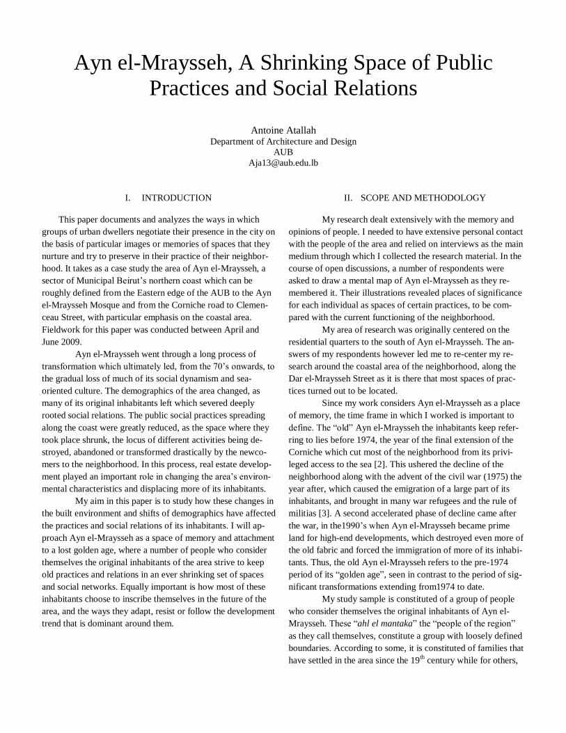
when people visited one another (Fig.1).
To the west of my site, where Café Jamal now stands,
were concentrated 3 beaches, Jamal, Normandie and YMCA
beaches. All three had their own quays and were private, albeit
affordable to most inhabitants of the area (Fig.2). A bit further
up, at the edge of the formerly truncated Avenue de Paris, was
Café Fontana visited by men of the area and people all over
Beirut and known for its colored lights, singers and belly danc-
ers which Ibrahim Nejm and Florence Serof remembered could
be seen from the coast. Then came the neighborhood’s fishing
harbor, where the fishermen gathered, kept and prepared their
nets and boats, and often lived in shacks on the rocks. Further
to the east were two quays owned by the Kaddoura and the
Nsouli buildings, which were private but easily accessed by
anyone, as Ebitsam Akl and Zuheir Rawda recall. Next to the
Ayn el-Mraysseh mosque, was a boy’s school,
Figure 1. Ebtisam Akl’s mental map showing a concentration of
activities on the coast and along Dar Mraysseh Street
run by the Committee of Islamic Education as well as the
training grounds of the Najeh Sports Club visited by the youth.
Finally, the large extent of sea rocks offered space for play and
family gatherings around “fish grilled on the spot”, as Jamilah
Assaf remembers. That was especially the case on a large un-
built area located between the harbor and the beaches that also
acted as a playground. The other side of Dar Mraysseh Street
had its share of activities, with a number of night clubs such as
the “222 discotheque”, a coffee shop located in the Seblini
house, popular among the men of the area and a number of
shacks offering food for the fishermen (fig.4).
Figure 2. Picture of Jamal Beach taken from the quays of the
Normandie Beach. (Courtesy of Ibrahim Nejm’s collection).
Figure 3. Recent picture of Café Jamal taken from the highway
which took away the beaches’ access to the sea
When the Corniche was built in 1974, it severed the
neighborhood from the sea. The Fontana was destroyed along
with the boy’s school. The three beaches didn’t give on the
water anymore, lost their “raison d’être” and died out, with
only Bains Jamal barely surviving, converted into a café
(fig.3). The Kaddoura and Nsouli buildings were amputated of
their quays, and most of the sea rocks disappeared under the
road. Only the harbor remained, as the lobbying of Lebanon’s
Fishermen’s Union forced the city planners to bridge above the
entrance of the harbor, allowing for an access to and from the
sea [4]. The loss of leisure activities on the coast affected simi-
lar functions on Dar Mraysseh Street and all discotheques
closed down. Later on, the fishermen’s café and the food stands
would end up destroyed in the later development rush of the
1990’s. This led the commercial activities to shift to the Cor-
niche road, which became the busiest axis in the neighborhood.
The inhabitants thus lost their strong connection to the sea [2],
which was part of their daily life: “we had the water at the foot
of the bed, now we have concrete” said Mounir el-Sayyed.
Most importantly, Ayn el-Mraysseh lost its public component
as most spaces of public interaction disappeared or became
impracticable.
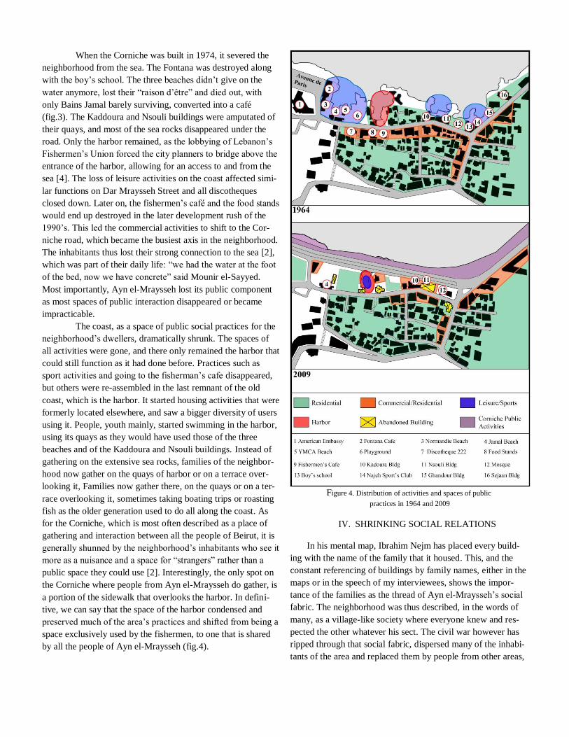
The coast, as a space of public social practices for the
neighborhood’s dwellers, dramatically shrunk. The spaces of
all activities were gone, and there only remained the harbor that
could still function as it had done before. Practices such as
sport activities and going to the fisherman’s cafe disappeared,
but others were re-assembled in the last remnant of the old
coast, which is the harbor. It started housing activities that were
formerly located elsewhere, and saw a bigger diversity of users
using it. People, youth mainly, started swimming in the harbor,
using its quays as they would have used those of the three
beaches and of the Kaddoura and Nsouli buildings. Instead of
gathering on the extensive sea rocks, families of the neighbor-
hood now gather on the quays of harbor or on a terrace over-
looking it, Families now gather there, on the quays or on a ter-
race overlooking it, sometimes taking boating trips or roasting
fish as the older generation used to do all along the coast. As
for the Corniche, which is most often described as a place of
gathering and interaction between all the people of Beirut, it is
generally shunned by the neighborhood’s inhabitants who see it
more as a nuisance and a space for “strangers” rather than a
public space they could use [2]. Interestingly, the only spot on
the Corniche where people from Ayn el-Mraysseh do gather, is
a portion of the sidewalk that overlooks the harbor. In defini-
tive, we can say that the space of the harbor condensed and
preserved much of the area’s practices and shifted from being a
space exclusively used by the fishermen, to one that is shared
by all the people of Ayn el-Mraysseh (fig.4).
Figure 4. Distribution of activities and spaces of public
practices in 1964 and 2009
IV. SHRINKING SOCIAL RELATIONS
In his mental map, Ibrahim Nejm has placed every build-
ing with the name of the family that it housed. This, and the
constant referencing of buildings by family names, either in the
maps or in the speech of my interviewees, shows the impor-
tance of the families as the thread of Ayn el-Mraysseh’s social
fabric. The neighborhood was thus described, in the words of
many, as a village-like society where everyone knew and res-
pected the other whatever his sect. The civil war however has
ripped through that social fabric, dispersed many of the inhabi-
tants of the area and replaced them by people from other areas,
from the south and eastern suburbs [3]. Few of the original
inhabitants came back, and nowadays, according to Mukhtar
Seblini, only around 20% of the people living in Ayn el-
Mraysseh were born in it and are considered “men el mantaka”
by those that remained.
Most disliked are the foreigners, mainly from the Arab
Gulf, who live in the new high rise luxury buildings that were
built starting the1990’s and who “have no sentiments for Ayn
el-Mraysseh, who are here to enjoy the view and nothing more”
as Ibrahim Nejm said. “You don’t see them, not even on their
balconies, they have bought the land from people that had their
lives here, to spend a few leisure days every year”, said Mukh-
tar Seblini. As for the Lebanese who settled from other areas,
they are still seen as foreigners, often with distrust.
Indeed, whether the “new comers”, as they are often
called, settled during the war or in the 1990’s onwards, there is
little interaction between them and the original inhabitants. It is
very often the “new comers” to the neighborhood who choose
to reduce interaction with the neighborhood around them. That
is most clearly represented by the new residential towers that
stand high above the street, behind tall walls and whose inhabi-
tants most often enter and leave by car, rarely using the main
pedestrian entrance which anyways faces the cornice and turns
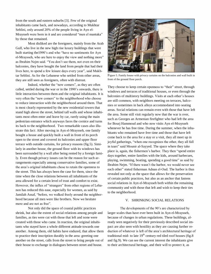
its back to the neighborhood. Two remarkable cases also illu-
strate this fact: After moving in Ayn el-Mraysseh, one family
bought a house and quickly built a wall in front of its porch
open to the street and covered its balconies and upper floor
terrace with outside curtains, for privacy reasons (fig.5). Simi-
larly in another house, the ground floor with its windows has
been surrounded by a wall after being rented by a foreign fami-
ly. Even though privacy issues can be the reason for such ar-
rangements especially among conservative families, some of
the area’s original inhabitants chose to retain the openness to
the street. This has always been the case for them, since the
time when the close relations between all inhabitants of the
area allowed for a certain level of trust and comfort to exist.
However, the influx of “strangers” from other regions of Leba-
non has reduced this ease, especially for women, as said by
Jamilah Assaf, “before, we walked freely around the neighbor-
hood because all men were like brothers. Now we hesitate
more and are not as free”.
Not only did the space of coastal public practices
shrink, but also the extent of social relations among people and
families, as ties were cut with those that left and none were
created with those who came. In reaction, the original inhabi-
tants who stayed have a whole different attitude towards one
another. Among them, old habits have endured, that allow them
to practice their inscription durably in the area: greeting one
another on the street, calls from the street to bring people out of
their house to exchange in dialogues between street and house.
Figure 5. Family house with privacy curtains on the balconies and wall built in
front of the ground floor porch.
They choose to keep certain openness to “their” street, through
windows and terraces of traditional houses, or even through the
balconies of multistory buildings. Visits at each other’s houses
are still common, with neighbors meeting on terraces, balco-
nies or sometimes in back alleys accommodated into seating
areas. Social relations can remain even with those that have left
the area. Some still visit regularly now that the war is over,
such as Georges an Armenian firefighter who had left the area
for Bourj Hammoud and who now visits Ayn el-Mraysseh
whenever he has free time. During the summer, when the inha-
bitants who remained have free time and those that have left
come back to the area for a stay or a visit, they all meet up in
joyful gatherings, “when one recognizes the other, they all fall
in tears” said Mounir al-Sayyed. The space where they take
place is, again, the fishermen’s harbor. They then “spend entire
days together, entire families with the kids, around barbecues,
playing, swimming, boating, spending a good time” as said by
Ibrahim Nejm. “If there wasn’t the harbor, we would never see
each other” stated fisherman Adnan el-Oud. The harbor is thus
revealed not only as the space that allows for the preservation
of certain public practices, but also as an anchor that fastens
social relations in Ayn el-Mraysseh both within the remaining
community and with those that left and wish to keep their ties
to the neighborhood.
V. SHRINKING SOCIAL RELATIONS
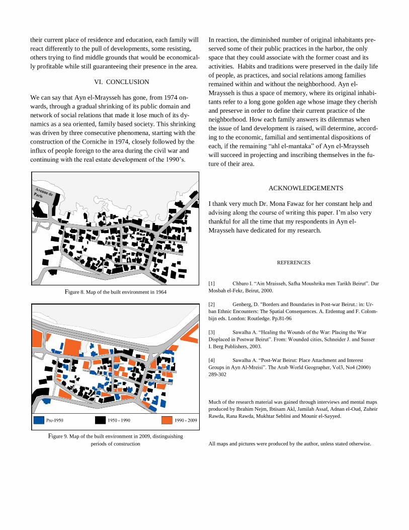
The developments of the 90’s are characterized by
larger scales than have ever been built in Ayn el-Mraysseh,
because of changes in urban regulations. These buildings, al-
ready seen negatively for their previously described social im-
pact are also seen with hostility as they are causing further re-
duction of whatever is left of the area’s architectural heritage of
traditional mid- to late 19th century red tiled roof houses (fig.8
and fig.9). We can see the current interest the inhabitants give
to their architectural heritage, and their will to protect it, as
aeaction against the dire danger faced by what little is left of it.
Concurrently, the inhabitants, who see themselves as being in
danger of extinction in their own area, project their state of
emergency in the danger of destruction faced by their built en-
vironment, the most physical expression of their presence in
the area. The old houses have thus become both representations
of the area’s memory that needs to be saved, and representa-
tional objects of the inhabitants of Ayn el-Mraysseh.
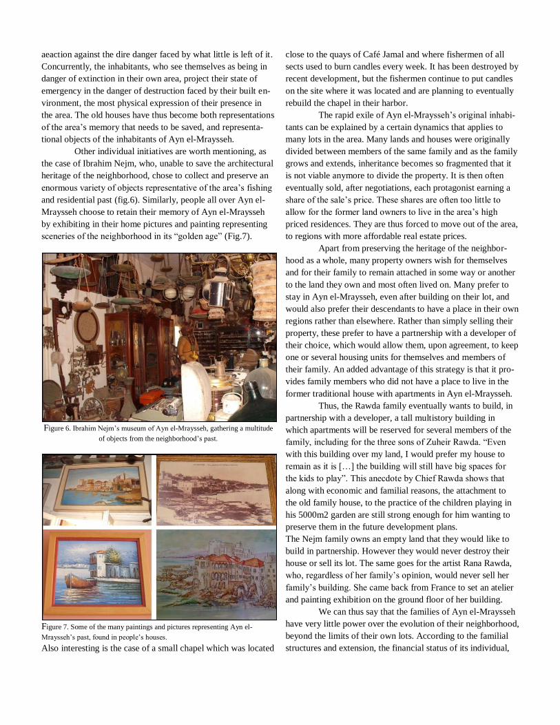
Other individual initiatives are worth mentioning, as
the case of Ibrahim Nejm, who, unable to save the architectural
heritage of the neighborhood, chose to collect and preserve an
enormous variety of objects representative of the area’s fishing
and residential past (fig.6). Similarly, people all over Ayn el-
Mraysseh choose to retain their memory of Ayn el-Mraysseh
by exhibiting in their home pictures and painting representing
sceneries of the neighborhood in its “golden age” (Fig.7).
Figure 6. Ibrahim Nejm’s museum of Ayn el-Mraysseh, gathering a multitude
of objects from the neighborhood’s past.
Figure 7. Some of the many paintings and pictures representing Ayn el-
Mraysseh’s past, found in people’s houses.
Also interesting is the case of a small chapel which was located
close to the quays of Café Jamal and where fishermen of all
sects used to burn candles every week. It has been destroyed by
recent development, but the fishermen continue to put candles
on the site where it was located and are planning to eventually
rebuild the chapel in their harbor.
The rapid exile of Ayn el-Mraysseh’s original inhabi-
tants can be explained by a certain dynamics that applies to
many lots in the area. Many lands and houses were originally
divided between members of the same family and as the family
grows and extends, inheritance becomes so fragmented that it
is not viable anymore to divide the property. It is then often
eventually sold, after negotiations, each protagonist earning a
share of the sale’s price. These shares are often too little to
allow for the former land owners to live in the area’s high
priced residences. They are thus forced to move out of the area,
to regions with more affordable real estate prices.
Apart from preserving the heritage of the neighbor-
hood as a whole, many property owners wish for themselves
and for their family to remain attached in some way or another
to the land they own and most often lived on. Many prefer to
stay in Ayn el-Mraysseh, even after building on their lot, and
would also prefer their descendants to have a place in their own
regions rather than elsewhere. Rather than simply selling their
property, these prefer to have a partnership with a developer of
their choice, which would allow them, upon agreement, to keep
one or several housing units for themselves and members of
their family. An added advantage of this strategy is that it pro-
vides family members who did not have a place to live in the
former traditional house with apartments in Ayn el-Mraysseh.
Thus, the Rawda family eventually wants to build, in
partnership with a developer, a tall multistory building in
which apartments will be reserved for several members of the
family, including for the three sons of Zuheir Rawda. “Even
with this building over my land, I would prefer my house to
remain as it is […] the building will still have big spaces for
the kids to play”. This anecdote by Chief Rawda shows that
along with economic and familial reasons, the attachment to
the old family house, to the practice of the children playing in
his 5000m2 garden are still strong enough for him wanting to
preserve them in the future development plans.
The Nejm family owns an empty land that they would like to
build in partnership. However they would never destroy their
house or sell its lot. The same goes for the artist Rana Rawda,
who, regardless of her family’s opinion, would never sell her
family’s building. She came back from France to set an atelier
and painting exhibition on the ground floor of her building.
We can thus say that the families of Ayn el-Mraysseh
have very little power over the evolution of their neighborhood,
beyond the limits of their own lots. According to the familial
structures and extension, the financial status of its individual,
their current place of residence and education, each family will
react differently to the pull of developments, some resisting,
others trying to find middle grounds that would be economical-
ly profitable while still guaranteeing their presence in the area.
VI. CONCLUSION
We can say that Ayn el-Mraysseh has gone, from 1974 on-
wards, through a gradual shrinking of its public domain and
network of social relations that made it lose much of its dy-
namics as a sea oriented, family based society. This shrinking
was driven by three consecutive phenomena, starting with the
construction of the Corniche in 1974, closely followed by the
influx of people foreign to the area during the civil war and
continuing with the real estate development of the 1990’s.
Figure 8. Map of the built environment in 1964
Figure 9. Map of the built environment in 2009, distinguishing
periods of construction
In reaction, the diminished number of original inhabitants pre-
served some of their public practices in the harbor, the only
space that they could associate with the former coast and its
activities. Habits and traditions were preserved in the daily life
of people, as practices, and social relations among families
remained within and without the neighborhood. Ayn el-
Mraysseh is thus a space of memory, where its original inhabi-
tants refer to a long gone golden age whose image they cherish
and preserve in order to define their current practice of the
neighborhood. How each family answers its dilemmas when
the issue of land development is raised, will determine, accord-
ing to the economic, familial and sentimental dispositions of
each, if the remaining “ahl el-mantaka” of Ayn el-Mraysseh
will succeed in projecting and inscribing themselves in the fu-
ture of their area.
ACKNOWLEDGEMENTS
I thank very much Dr. Mona Fawaz for her constant help and
advising along the course of writing this paper. I’m also very
thankful for all the time that my respondents in Ayn el-
Mraysseh have dedicated for my research.
REFERENCES
[1] Chbaro I. “Ain Mraisseh, Safha Moushrika men Tarikh Beirut”. Dar
Mosbah el-Fekr, Beirut, 2000.
[2] Genberg, D. "Borders and Boundaries in Post-war Beirut.: in: Ur-
ban Ethnic Encounters: The Spatial Consequences. A. Erdentug and F. Colom-
bijn eds. London: Routledge. Pp.81-96
[3] Sawalha A. “Healing the Wounds of the War: Placing the War
Displaced in Postwar Beirut”. From: Wounded cities, Schneider J. and Susser
I. Berg Publishers, 2003.
[4] Sawalha A. “Post-War Beirut: Place Attachment and Interest
Groups in Ayn Al-Mreisi”. The Arab World Geographer, Vol3, No4 (2000)
289-302
Much of the research material was gained through interviews and mental maps
produced by Ibrahim Nejm, Ibtisam Akl, Jamilah Assaf, Adnan el-Oud, Zuheir
Rawda, Rana Rawda, Mukhtar Seblini and Mounir el-Sayyed.
All maps and pictures were produced by the author, unless stated otherwise.
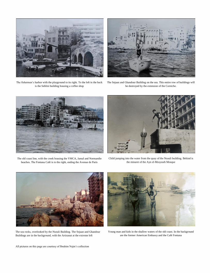
The fishermen’s harbor with the playground to its right. To the left in the back
is the Seblini building housing a coffee shop
The old coast line, with the creek housing the YMCA, Jamal and Normandie
beaches. The Fontana Café is to the right, ending the Avenue de Paris
The sea rocks, overlooked by the Nsouli Building. The Sejaan and Ghandour
Buildings are in the background, with the Artisanat at the extreme left
All pictures on this page are courtesy of Ibrahim Nejm’s collection
The Sejaan and Ghandour Building on the sea. This entire row of buildings will
be destroyed by the extension of the Corniche.
Child jumping into the water from the quay of the Nsouli building. Behind is
the minaret of the Ayn el-Mraysseh Mosque
Young man and kids in the shallow waters of the old coast. In the background
are the former American Embassy and the Café Fontana