
Automated reference point determination at radio...
16
Automated reference point determination at radio telescopes Slide 1 18.05.2016 A contribution to the Global Geodetic Observing System Laboratory for Industrial Metrology Prof. Dr.-Ing. Cornelia Eschelbach| LUMINAR - End of Project Workshop – 18.-19. May 2016
Transcript of Automated reference point determination at radio...

Automated reference point determination at radio telescopes
Slide 1 18.05.2016
A contribution to the Global Geodetic Observing System
Laboratory for Industrial Metrology
Prof. Dr.-Ing. Cornelia Eschelbach| LUMINAR - End of Project Workshop – 18.-19. May 2016

Agenda
1. Introduction
2. Reference point determination with HEIMDALL
3. Uncertainty budgeting
4. Results of reference point determination during CONT14
5. Outlook
Slide 2 18.05.2016 Prof. Dr.-Ing. Cornelia Eschelbach| LUMINAR - End of Project Workshop – 18.-19. May 2016

1. Introduction
Global Geodetic Observing System (GGOS)
• Geodetic infrastructure for monitoring of the shape, the gravity field and the rotational model of the Earth
• Combination of different geodetic techniques, different models and different approaches to ensure long-term, precise monitoring of the geodetic observables
• Providing a stable and accurate global reference frame
United Nations resolution on the importance of a global terrestrial reference frame for sustainable development
Slide 3 18.05.2016 Prof. Dr.-Ing. Cornelia Eschelbach| LUMINAR - End of Project Workshop – 18.-19. May 2016

1. Introduction
Global Geodetic Reference Frame
• Combining results from different space geodetic techniques
• Very Long Baseline Interferometry (VLBI)
• Global Navigation Satellite System (GNSS)
• Doppler Orbitography and Radiopositioning Integrated by Satellite (DORIS)
• Satellite Laser Ranging (SLR) / Lunar Laser Ranging (LLR)
• Co-location stations as connection
Local-tie vectors between the reference points of the space geodetic techniques
• Requirements for the local-tie vector
• High accuracy of about 1 mm
• Continuously determined to investigate time-stability
• Automations in measurement and determination process
Slide 4 18.05.2016 Prof. Dr.-Ing. Cornelia Eschelbach| LUMINAR - End of Project Workshop – 18.-19. May 2016
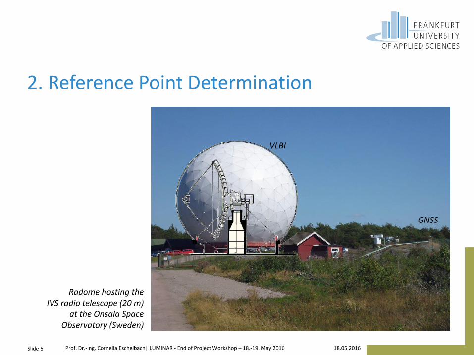
2. Reference Point Determination
Radome hosting the IVS radio telescope (20 m)
at the Onsala Space Observatory (Sweden)
Slide 5 18.05.2016 Prof. Dr.-Ing. Cornelia Eschelbach| LUMINAR - End of Project Workshop – 18.-19. May 2016
VLBI
GNSS

2. Reference Point Determination
HEIMDALL
• OpenSource Software implemented in Java
• HyperSQL for central data storage
• Components
• Sensor communication
• Observation schedule based on VLBI-schedule
• Coordinate-based bundle adjustment
• IVS-reference point determination
• Analysis of time series / filter
Slide 6 18.05.2016 Prof. Dr.-Ing. Cornelia Eschelbach| LUMINAR - End of Project Workshop – 18.-19. May 2016

2. Reference Point Determination
Calculation model
• IVS-RP definition: orthogonal projection of the secondary axis onto the primary axis
• Real-time capable model
𝐏RP estimated from 𝐏Obs-trajectory
𝐏RP IVS-reference point 𝐄cc axis offset 𝛾 non-orthogonality 𝜃 and 𝜙 axis tilting O𝛼 and O𝜀 orientation angle
Slide 7 18.05.2016 Prof. Dr.-Ing. Cornelia Eschelbach| LUMINAR - End of Project Workshop – 18.-19. May 2016
Tely
'y
b
Ebeneyx ''
a
a
1,1P
2,1P
cce
Telx
Telz
O
Azimutachse
Elevationsachse
'z
'x
Obsx
Obsz
Obsy
RPP
Px'
2/
reference point
azim
uth
axis
Tely
'y
b
Ebeneyx ''
a
a
1,1P
2,1P
cce
Telx
Telz
O
Azimutachse
Elevationsachse
'z
'x
Obsx
Obsz
Obsy
RPP
Px'
2/
elevation axis
azimuth axis
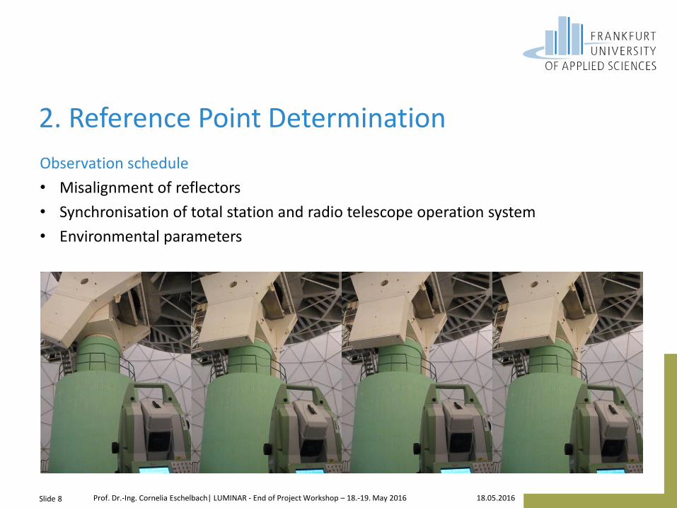
2. Reference Point Determination
Observation schedule
• Misalignment of reflectors
• Synchronisation of total station and radio telescope operation system
• Environmental parameters
Slide 8 18.05.2016 Prof. Dr.-Ing. Cornelia Eschelbach| LUMINAR - End of Project Workshop – 18.-19. May 2016

2. Reference Point Determination
Coordinate-based bundle adjustment
• Conversion of polar measurements to Cartesian spatial coordinates of each stand point
• Conforme spatial parameters coordinate transformation
• Valid for stand points that are unrelated to the plumb line
• Independent of reference frame
All calculations in the global reference frame
Slide 9 18.05.2016 Prof. Dr.-Ing. Cornelia Eschelbach| LUMINAR - End of Project Workshop – 18.-19. May 2016

3. Uncertainty budgeting
Stochastic model for a polar measurement system
• Manufacture's calibration procedure
• Geometric compensation model suggested by Hughes et. al. (2011)
• Compensation model for the measurement process
28 uncertainty parameters
• 16 for instrument geometry
• 12 for measurement process
Slide 10 18.05.2016 Prof. Dr.-Ing. Cornelia Eschelbach| LUMINAR - End of Project Workshop – 18.-19. May 2016
𝑎𝛷,0, 𝑎𝛷,1, 𝑏𝛷,1, 𝑎𝛷,2, 𝑏𝛷,2, 𝜉𝛷
𝑎𝛩,1, 𝑏𝛩,1, 𝑎𝛩,2, 𝑏𝛩,2, 𝜉𝛩
𝛩
𝛷 𝑒𝛩,𝛷, 𝑡𝑑,𝑦, 𝑡𝑑,𝑧, 𝜅, 𝜈
𝜆, μ, 𝜉𝑑
𝑐𝑥0,𝑐𝑦0
, 𝑐𝑧0
𝜁𝑑 ,𝜁𝛩,𝜁𝛷
𝜏𝑑,𝜏𝛩,𝜏𝛷
Yaw − axis
Laser − beam 𝑑
Pitch − axis
Pitch angle encoder
Yaw angle encoder Reflector
© J Geo DOI 10.1007/s00190-016-0887-8

3. Uncertainty budgeting
Time-dependent stochastic model
• Statistical temporal dependencies
• Persistance of a series expressed by auto-covariance function
Slide 11 18.05.2016 Prof. Dr.-Ing. Cornelia Eschelbach| LUMINAR - End of Project Workshop – 18.-19. May 2016
© J Geo DOI 10.1007/s00190-016-0887-8

3. Uncertainty budgeting
Synchronizing
• Latency time of polar observations: time lag between angle and distance measurement of the total station
• Synchronization error between total station and radio telescope
Influence included by using Monte Carlo simulation
Slide 12 18.05.2016 Prof. Dr.-Ing. Cornelia Eschelbach| LUMINAR - End of Project Workshop – 18.-19. May 2016
© J Geo DOI 10.1007/s00190-016-0887-8

4. Results of reference point determination
CONT14
• 15-day-long VLBI campagne in May 2014 yielded in 15 collateral reference point determinations
• 20 m radio telescope at the Onsala Space Observatory covered by a radome
• Network realization consisting of eleven fixed points inside the radome and several stand points outside the radome for connection the IGS reference point
Slide 13 18.05.2016 Prof. Dr.-Ing. Cornelia Eschelbach| LUMINAR - End of Project Workshop – 18.-19. May 2016
© J Geo DOI 10.1007/s00190-016-0887-8

4. Results of reference point determination
CONT14
• Recursive parameter estimation
• Stability check
• Time series includes prior information
• Maximum uncertainty of the hyper confidence ellipsoid of the reference point 𝑢max, 95 % = 0.5 mm
Reliable results fulfill requirements < 1 mm
Slide 14 18.05.2016 Prof. Dr.-Ing. Cornelia Eschelbach| LUMINAR - End of Project Workshop – 18.-19. May 2016
© J Geo DOI 10.1007/s00190-016-0887-8

5. Outlook
Local-tie measurement
• Reference point determination of IVS radio telescope
• Connection to the local network
• Determination of reference points of several other techniques
CONT14 local-tie vector (VLBI-GNSS) at ONSALA better than 1 mm
Slide 15 18.05.2016 Prof. Dr.-Ing. Cornelia Eschelbach| LUMINAR - End of Project Workshop – 18.-19. May 2016

Thank you for your attention
Slide 16 18.05.2016 Prof. Dr.-Ing. Cornelia Eschelbach| http://fra-uas.de/metrology


