AutoCAD - Autodeskimages.autodesk.com/apac_korea_main/files/autocad_civil...Leading the way in the...
6
AutoCAD ® Civil 2010 Give your productivity a boost.
Transcript of AutoCAD - Autodeskimages.autodesk.com/apac_korea_main/files/autocad_civil...Leading the way in the...

AutoCAD®
Civil 2010
Give your productivity a boost.

Coordinate System TransformationsDrawing transformations used to be time-consuming and error-prone. Using AutoCAD Civil, surveyors can quickly convert local northings and eastings to defined coordinate systems from around the world. Use sea-level scale factors and grid-scale factors to quickly transform local coordinates to projected coordinate systems.
Traverse and Least Squares AdjustmentsAutoCAD Civil provides surveyors with tools and settings to simplify traverse adjustments. You can choose the type of error to analyze and which adjustment method to use by selecting the Crandall rule, compass rule, transit rule, or least squares. Surveyors can also perform a traverse analysis using both horizontal and vertical adjustment methods. Easily view traverse information using graphical on-screen displays or in field book notation style for easier editing. Map CheckMore quickly evaluate errors and omissions within legal descriptions or platted labels using the interactive map check function.
Parcel LayoutGenerate parcels by converting existing AutoCAD polylines or by using flexible layout tools to automatically size parcels based on frontage offset, minimum width, and minimum and maximum depths. Use the intelligent topology to manage parcels so that a change to one parcel is automatically reflected in neighboring parcels.
AutoCAD Civil software, the better AutoCAD software for civil engineering design and construction documentation, helps civil engineering technicians, drafters, and surveyors complete projects faster. Boost productivity and help streamline time-consuming design tasks. Deliver more consistent and better coordinated construction documentation with design and drafting that stays synchronized. Accelerate learning in a familiar AutoCAD environment.
Import Survey DataEasily convert and process proprietary raw survey data directly into AutoCAD Civil. Automate line work for planimetric or topographic creation—with or without field book file formatting—using the AutoCAD Civil field-to-finish process.
PointsHarness and manage the power of points by using description keys, styles, and point groups. Points can be imported multiple ways, providing the flexibility to work with various data sources. As data is imported, users can automatically populate point groups with simple or sophisticated querying methods.
Coordinate SystemsWork with more than 4,000 real-world coordinate systems to more accurately georeference your AutoCAD Civil design data.
Whether you work on land development, transportation, or environmental projects, AutoCAD Civil software is the right choice for your organization, providing integrated surveying, design, and documentation tools.
Not Just Faster: Higher Quality Reduce the time it takes for survey tasks, design, and documentation creation, and implement changes easily and more accurately so you can realize improved results faster.
On Schedule and on Budget Work in a familiar AutoCAD® environment with tools and processes you already know. With design and drafting that remain synchronized in AutoCAD Civil, the entire team can work from the same up-to-date project data, so everyone stays better coordinated throughout all project phases, helping to avoid costly errors or omissions.
Leading the way in the delivery of field to finish, AutoCAD® Civil software provides a comprehensive solution for civil engineering projects.
Setting the Course for High-Quality Design

Help streamline project workflows by automating time-consuming tasks that keep design and drafting data synchronized.
Tools Purpose-Built for Design
Preliminary Design Pull in aerial imagery and terrain models from the Google Earth™ application; import road centerlines, pipe networks, and wetlands boundaries using Autodesk spatial data format (SDF); and then use the purpose-built design tools to lay out preliminary road and lot designs—all without hiring a survey crew.
SurfacesAutoCAD Civil software supports large surface models while maintaining dynamic relationships to source data, including points, contours, breaklines, corridor models, and grading objects. Once generated, the surface can be used to display contours, catchment areas, flow paths, elevation and slope analysis, and 3D render-ready views.
GradingTeam members can use the powerful daylighting and grade projection tools to generate surface models for any type of grading projection. You also get easy-to-use graphical and tabular grading manipulation tools for use in the development of any surface.
Corridor ModelingCorridor modeling combines horizontal and vertical geometric constraints with customizable cross sectional components called subassemblies to create a dynamic model of roads and other transportation systems. Use the included subassemblies—ranging from travel lanes, sidewalks, and ditches to complex lane components—or create your own to match any conceivable design standard. AutoCAD Civil software also provides an interactive intersection builder that helps to create complex models that remains dynamic as your designs change.
Criteria-Based Geometric DesignQuickly lay out dynamic plan and profile alignment geometry with local design criteria that you specify. These constraints remain in place when using interactive “best fit,” PI-based (point of intersection), or highly flexible element-based layout approaches.
Pipes Use rule-based tools to lay out sanitary and storm drainage systems. Make changes to pipes and structures using graphical or numerical input, and conduct interference checks. Plot and complete final drafting of the pipe network in plan, profile, and section views, and share pipe network information, such as invert elevations, size, slope, and type with external analysis applications or compatible Autodesk products such as AutoCAD Civil 3D.
Earthwork CalculationsAs the coordination between engineers and contractors becomes increasingly important, mass haul diagrams continue to be a vital tool for planning the movement, amount, and placement of material during construction. Use AutoCAD Civil to generate mass haul diagrams for computing the distance over which cut and fill can balance, the amount of material to be moved, the direction of movement, and the identification of borrow pits and dump sites.
Multiple design updates. All deliverables coordinated.
Better Communicate Winning Ideas. Quickly and efficiently convey designs to the public, review boards, and other stakeholders.
Model. Use the intelligent and dynamic tools to more quickly make a design change at any stage of the project.
Reports. When a change to the design is made, all the crucial information for your reports and tables update as well.
Documentation. The model automatically reflects any changes to drafting and annotation throughout the project.
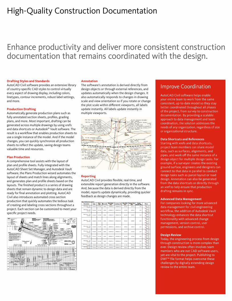
Improve CoordinationAutoCAD Civil software helps enable your entire team to work from the same consistent, up-to-date model so they stay better coordinated throughout all phases of the project, from survey to construction documentation. By providing a scalable approach to data management and team coordination, the solution addresses the needs of any organization, regardless of size or organizational structure.
Data Shortcuts and References Starting with xrefs and data shortcuts, project team members can share model data, such as surfaces, alignments, and pipes, and work off the same instance of a design object for multiple design tasks. For example, if a surveyor creates the existing ground surface, engineers and designers can connect to that data in parallel to conduct design tasks such as parcel layout or road design. Annotation can also be generated from the data shortcuts or directly through an xref to help ensure that production drafting remains in sync.
Advanced Data Management For companies looking for more advanced data management for civil engineering workflow, the addition of Autodesk Vault technology enhances the data shortcut functionality with advanced change management, version control, user permissions, and archive control.
Design Review Today, the engineering process from design through construction is more complex than ever. Design review often involves team members who are not CAD software users, yet are vital to the project. Publishing to DWF™ file format helps overcome these challenges by digitally extending design review to the entire team.
Enhance productivity and deliver more consistent construction documentation that remains coordinated with the design.
High-Quality Construction Documentation
Drafting Styles and StandardsAutoCAD Civil software provides an extensive library of country-specific CAD styles to control virtually every aspect of drawing display, including colors, linetypes, contour increments, robust label settings, and more.
Production Drafting Automatically generate production plans such as fully annotated section sheets, profiles, grading plans, and more. Most important, drafting can be generated across multiple drawings by using xrefs and data shortcuts or Autodesk® Vault software. The result is a workflow that enables production sheets to use a single instance of the model. And if the model changes, you can quickly synchronize all production sheets to reflect the update, saving design teams valuable time and resources.
Plan Production A comprehensive tool assists with the layout of plan and profile sheets. Fully integrated with the AutoCAD Sheet Set Manager, and Autodesk Vault software, the Plans Production wizard automates the layout of sheets and match lines along alignments, and generates plan and profile sheets based on the layouts. The finished product is a series of drawing sheets that remain dynamic to design data and are ready for final annotation and plotting. AutoCAD Civil also introduces automated cross section production that quickly automates the tedious task of creating and labeling cross sections throughout a project. Each section can be customized to meet your specific project needs.
Annotation The software’s annotation is derived directly from design objects or through external references, and updates automatically when the design changes. It also automatically responds to changes in drawing scale and view orientation so if you rotate or change the plot scale within different viewports, all labels update instantly. All labels update instantly in multiple viewports.
Reporting AutoCAD Civil provides flexible, real-time, and extensible report generation directly in the software. And, because the data is derived directly from the model, reports update dynamically, providing quicker feedback as design changes are made.
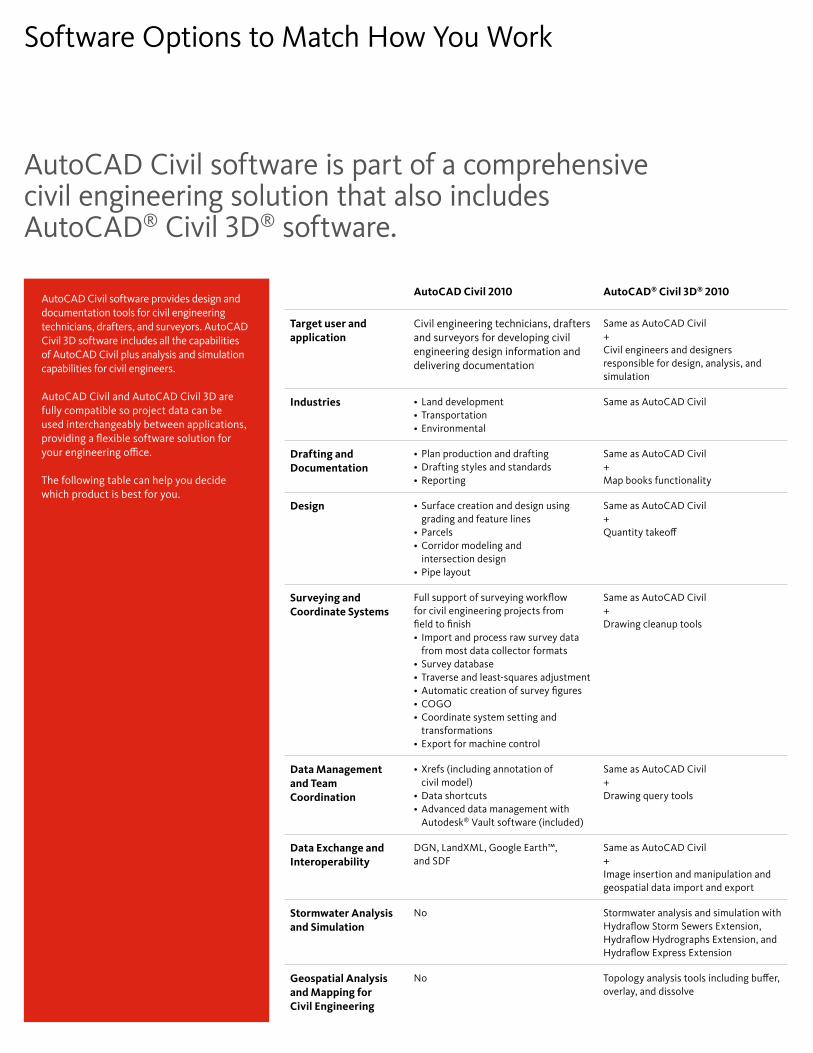
AutoCAD Civil software is part of a comprehensive civil engineering solution that also includes AutoCAD® Civil 3D® software.
Software Options to Match How You Work
AutoCAD Civil 2010 AutoCAD® Civil 3D® 2010
Target user and application
Civil engineering technicians, drafters and surveyors for developing civil engineering design information and delivering documentation
Same as AutoCAD Civil +Civil engineers and designers responsible for design, analysis, and simulation
Industries Land development•Transportation•Environmental•
Same as AutoCAD Civil
Drafting and Documentation
Plan production and drafting•Drafting styles and standards•Reporting•
Same as AutoCAD Civil+Map books functionality
Design Surface creation and design using •grading and feature linesParcels• Corridor modeling and •intersection designPipe layout•
Same as AutoCAD Civil+Quantity takeoff
Surveying and Coordinate Systems
Full support of surveying workflow for civil engineering projects from field to finish
Import and process raw survey data •from most data collector formats Survey database•Traverse and least-squares adjustment•Automatic creation of survey figures•COGO• Coordinate system setting and •transformationsExport for machine control•
Same as AutoCAD Civil+Drawing cleanup tools
Data Management and Team Coordination
Xrefs (including annotation of •civil model)Data shortcuts • Advanced data management with •Autodesk® Vault software (included)
Same as AutoCAD Civil + Drawing query tools
Data Exchange and Interoperability
DGN, LandXML, Google Earth™, and SDF
Same as AutoCAD Civil+Image insertion and manipulation and geospatial data import and export
Stormwater Analysis and Simulation
No Stormwater analysis and simulation with Hydraflow Storm Sewers Extension, Hydraflow Hydrographs Extension, and Hydraflow Express Extension
Geospatial Analysis and Mapping for Civil Engineering
No Topology analysis tools including buffer, overlay, and dissolve
AutoCAD Civil software provides design and documentation tools for civil engineering technicians, drafters, and surveyors. AutoCAD Civil 3D software includes all the capabilities of AutoCAD Civil plus analysis and simulation capabilities for civil engineers.
AutoCAD Civil and AutoCAD Civil 3D are fully compatible so project data can be used interchangeably between applications, providing a flexible software solution for your engineering office.
The following table can help you decide which product is best for you.

Using AutoCAD Civil, we are able to immediately confirm the design intent with real life applicability and to better coordinate the inextricable relationship between Planning/Urban Design and Architecture.
— Thomas M. Gallas Executive Vice President Torti Gallas and Partners Inc.
Learn More or PurchaseAccess specialists worldwide who can provide product expertise, a deep understanding of your industry, and value that extends beyond your software purchase. To purchase AutoCAD Civil software, contact an Autodesk Premier Solutions Provider or Autodesk Authorized Reseller. Locate a reseller near you at www.autodesk.com/reseller.
Autodesk Learning and EducationFrom instructor-led or self-paced classes to online training or education resources, Autodesk offers learning solutions to fit your needs. Get expert guidance at an Autodesk Authorized Training Center (ATC®) site, access learning tools online or at your local bookstore, and validate your experience with Autodesk certifications. Learn more at www.autodesk.com/learning.
Autodesk Services and SupportAccelerate return on investment and optimize productivity with innovative purchase methods, companion products, consulting services, and support from Autodesk and Autodesk authorized partners. Designed to get you up to speed and keep you ahead of the competition, these tools help you make the most of your software purchase-no matter what industry you are in. Learn more at www.autodesk.com/servicesandsupport.
Autodesk SubscriptionGet the benefits of increased productivity, predictable budgeting, and simplified license management with Autodesk® Subscription. You get any new upgrades of your Autodesk software and any incremental product enhancements, if these are released during your Subscription term. In addition, you get exclusive license terms available only to Subscription members. A range of community resources, including web support direct from Autodesk technical experts, self-paced training, and e-Learning, help extend your skills and make Autodesk Subscription the best way to optimize your investment. Learn more at www.autodesk.com/subscription.
Autodesk is committed to sustainability. This brochure is printed on 25 percent postconsumer waste recycled paper.
Autodesk, AutoCAD, ATC, Civil 3D, and DWF are registered trademarks or trademarks of Autodesk, Inc., and/or its subsidiaries and/or affiliates in the USA and/or other countries. All other brand names, product names, or trademarks belong to their respective holders. Autodesk reserves the right to alter product offerings and specifications at any time without notice, and is not responsible for typographical or graphical errors that may appear in this document. © 2009 Autodesk, Inc. All rights reserved. BR0A1-000000-MZ51