Author's personal copy - INPE · RINDAT is a cloud-to-ground lightning detection network covering...
7
This article appeared in a journal published by Elsevier. The attached copy is furnished to the author for internal non-commercial research and education use, including for instruction at the authors institution and sharing with colleagues. Other uses, including reproduction and distribution, or selling or licensing copies, or posting to personal, institutional or third party websites are prohibited. In most cases authors are permitted to post their version of the article (e.g. in Word or Tex form) to their personal website or institutional repository. Authors requiring further information regarding Elsevier’s archiving and manuscript policies are encouraged to visit: http://www.elsevier.com/copyright
-
Upload
phunghuong -
Category
Documents
-
view
213 -
download
0
Transcript of Author's personal copy - INPE · RINDAT is a cloud-to-ground lightning detection network covering...

This article appeared in a journal published by Elsevier. The attachedcopy is furnished to the author for internal non-commercial researchand education use, including for instruction at the authors institution
and sharing with colleagues.
Other uses, including reproduction and distribution, or selling orlicensing copies, or posting to personal, institutional or third party
websites are prohibited.
In most cases authors are permitted to post their version of thearticle (e.g. in Word or Tex form) to their personal website orinstitutional repository. Authors requiring further information
regarding Elsevier’s archiving and manuscript policies areencouraged to visit:
http://www.elsevier.com/copyright

Author's personal copy
Relationship between cloud-to-ground discharge and penetrativeclouds: A multi-channel satellite application
Luiz A.T. Machado a,⁎, Wagner F.A. Lima a, Osmar Pinto Jr. a, Carlos A. Morales b
a Instituto Nacional de Pesquisas Espaciais, Rodovia Pres. Dutra, km 40, Cachoeira Paulista/SP-12630-000, Brazilb Instituto de Astronomia, Geofísica e Ciências Atmosféricas., Rua do Matão, 1226-Cidade Universitária-Sao Paulo/SP-05508-090, Brazil
a r t i c l e i n f o a b s t r a c t
Article history:Received 29 November 2007Received in revised form 20 August 2008Accepted 6 October 2008
This work presents a relationship between atmospheric cloud-to-ground discharges andpenetrative convective clouds. It combines Infrared and Water Vapor channels from the GOES-12 geostationary satellite with cloud-to-ground discharge data from the Brazilian IntegratedLightning Detection Network (RINDAT) during the period from January to February 2005. Thedifference between water vapor and infrared brightness temperature is a tracer penetratingclouds. Due to the water vapor channel's strong absorption, this difference is positive only duringovershooting cases, when convective clouds penetrate the stratosphere. From this difference andthe cloud-to-ground, discharge measured on the ground by RINDAT, it was possible to adjustexponential curves that relate the brightness temperature difference from these two channels tothe probability of occurrence of cloud-to-ground discharges, with a very large coefficient ofdetermination. If WV-IR brightness temperature difference is greater than−15 K there is a largepotential for cloud-to-ground discharge activity. As this difference increases the cloud-to-grounddischarge probably increases, for example: if this difference is equal to zero, the probability ofhavingat least one cloud-to-grounddischarge is 10.9%, 7.0% for two, 4.4% for four, 2.7% for eight and1.5% for sixteen cloud-to-ground discharges. Through this process, was developed a scheme thatestimates the probability of occurrence of cloud-to-ground discharge over all the continentalregion of South America.
© 2008 Elsevier B.V. All rights reserved.
Keywords:LightningPenetrative clouds
1. Introduction
Multispectral satellite analysis has demonstrated its abilityto depict cloud top features. The combination of water vaporand infrared window channels to describe deep convectiveclouds has been largely used; for instance, Medaglia et al.(2005) used these channels from geostationary satellites todevelop the Global Convective Diagnostic. Schmetz et al.(1997) noted through simultaneous observation of theMETEOSAT infrared window and water vapor channels anda line-by-line radiative transfer model that differences greater
than zero degrees between both channels are related toconvective clouds with high vertical extension. The simula-tions show that the larger brightness temperatures in thewater vapor channel are due to stratospheric water vapor,which absorbs radiation from overshooting tops and emitsradiation at a higher stratospheric temperature. Adler andMack (1986) studying the cloud top dynamics also foundstorm tops above the tropopause. Fritz and Laszlo (1993) alsonoted a brightness temperature from thewater vapor channelwarmer than from the infrared window channel over a regionassociated with deep convection. Kurino (1997) showed thatthe difference between both brightness temperatures can bevery useful in defining heavy precipitation related to deepconvection. Reudenbach et al. 2001 use this difference todiscriminate deep convection from thick Cirrus clouds. Stevaket al. (2007) used the higher spatial resolution images fromthe MODIS sensor to investigate the correlation between
Atmospheric Research 93 (2009) 304–309
⁎ Corresponding author. Instituto Nacional de Pesquisas Espaciais, Centrode Previsão de Tempo e Estudos Climáticos, Divisão de Satélites e SistemasAmbientais, Rodovia Pres. Dutra, km 40, Cachoeira Paulista/SP-12630-000,Brazil. Tel.: +55 12 31869399; fax: +55 12 31869291.
E-mail address: [email protected] (L.A.T. Machado).
0169-8095/$ – see front matter © 2008 Elsevier B.V. All rights reserved.doi:10.1016/j.atmosres.2008.10.003
Contents lists available at ScienceDirect
Atmospheric Research
j ourna l homepage: www.e lsev ie r.com/ locate /atmos

Author's personal copy
cloud top temperature and the water vapor-infrared windowdifference. They consider that a positive difference is possibleif each storm top generates some amount of moisture in thestratosphere, or by pre-existent stratospheric moisture in alayer above the cloud top. They found some cases that agreewith the previous results, where the positive difference is wellcorrelated with the minimal cloud top temperature. However,one case did not agree; the larger difference was notcorrelated with the minimal temperature. They also suggestthat different ice emissivity for each channel can in somecases explain these differences. Wang (2007), using a three-dimensional non-hydrostatic cloud model studied penetrat-ing convective clouds. He suggests that moisture plumes inthe stratosphere above convective clouds are generated bygravity waves and large instability over the cloud top due toconvection inside the storm.
The main goal of this study is to test the hypotheses thatthe difference between the water vapor and infrared channelcan be used as a tracer of penetrative clouds, and those cloudsare related to cloud-to-ground discharge.
Section 2 describes the data and the methodologyemployed in this study. Section 3 presents the resultsobtained, comparing satellite data and cloud-to-grounddischarge occurrence, and finally Section 4 presents theconclusion.
2. Methodology
Schmetz et al. (1997) suggested that positive differencesbetweenwater vapor and infrared brightness temperature areonly possible when deep convective clouds penetrate in thetropopause, moistening the stratosphere. The infrared islocated in the window channel; a region of the electromag-netic spectrumwhere the earth atmosphere's slightly absorbs
terrestrial radiation. However, the water vapor channel hasstrong absorption features and the brightness temperaturereported by this channel is nearly always colder than thatmeasured in the infrared channel. Therefore, the differencebetween the water vapor and infrared window channels isnormally negative, except if penetrating clouds go throughthe tropopause, moistening the stratosphere and then, as thetemperature increases in this layer, the difference can bepositive. In these cases, these positive differences are relatedto overshooting, which is normally associated with high deepconvective cloud tops with a large amount of ice, chieflyresponsible for the development of an electrical field insidethe clouds. The atmospheric cloud-to-ground discharges arethe response of the accumulated charges inside the cloud thatcan breakdown the dielectric air (Pinto et al., 2004). Thecenter of charges (positive and negative) is formed by severalcloud microphysical processes that transfer positive andnegative charges during the formation of cloud droplets,rain drops and ice particles (MacGorman and Rust, 1998).Moreover, observational studies revealed that lightning isassociated with glaciation, and the flash rate increases as thevolume of precipitation-sized ice particles in themixed-phaseregion increases and updraft strengthens (Baker et al., 1995;Petersen and Rutledge, 1998). The mixed phase clouds wereobserved to occur occasionally up to the homogeneous icenucleation and cloud electrification processes can extend upto the higher levels of the clouds (Heymsfield and Miloshe-vich, 1993).
Therefore, these very deep and high extended clouds areresponsible for a very large rate of cloud-to-ground dis-charges (Abdoulaev et al., 2001). The difference betweenthese two brightness temperatures can be used as a proxy forvery deep convection clouds (overshooting cases) associatedwith frequent lightning. Considering these features, we will
Fig. 1. a) Location of RINDAT sensors and the institution responsible for each sensor. b) Number of cloud-to-ground discharges per day on November 1st 2007, andlightning detection efficiency contour lines within the 20, 60, and 90%.
305L.A.T. Machado et al. / Atmospheric Research 93 (2009) 304–309

Author's personal copy
combine satellite with cloud-to-ground discharge data tocheck this hypothesis and quantify this relationship.
2.1. The RINDAT network
RINDAT is a cloud-to-ground lightning detection networkcovering the south and southeast parts of Brazil. The RINDAToperates at LF/VLF, with an average sensor baseline of300 km. It is a consortium of Brazilian electricity companiesand research institutes. RINDAT technology is based on LPATS(Lightning Position and Tracking System) and IMPACT(Improved Accuracy Using Combined Technology) sensorsfor locating lightning sources at medium and long ranges.More details about RINDAT can be found in Pinto (2003).During the period analyzed, the network was composed of 24sensors (8 Impact and 16 LPATS sensors), as indicated inFig. 1a. Data from the sensors are sent to a central processorwhere they are disseminated and stored and later reprocessedto recover data losses from possible delays in communicationlinks. The data employed in this study consist of time andlocation of the cloud-to-ground electrical discharges fromJanuary to February 2005. RINDAT is able to locate cloud–ground discharges with an average location accuracy of 500mfor flashes occurring inside the network. Fig. 1b shows thedetection efficiency contours. This work used only theinformation for Sao Paulo State that is inside the area withdetection efficiency higher than 90%.
2.2. GOES 12
The infrared (IR) 10.2–11.2 μm and the water vapor (WV)6.5–7.0 μm channels from GOES-12 were employed tocalculate the penetrating clouds. The data employed in this
studywere images (Full Disk, Northern Hemisphere Extendedand Southern Hemisphere) available every 30 min coveringthe period from January to February 2005. IR and WVchannels have the same resolution (4 km at the subsatellitepoint) and projection, therefore the overlay is straightforwardand the difference between the channels is easily performed.We have used full resolution images in the satellite projectionto perform the channel differences. The time of each imagenormally corresponds to the time of the first image scan line.In this work we did not use the image time but the specifictime of each scan line to combine precisely with the cloud-to-ground discharge.
2.3. Probability of occurrence
Inside the 90% lightning detection efficiency region weapplied the following methodology: For each image pixeldifference (WV-IR) we searched for the occurrence of cloud-to-ground discharge reported by RINDAT, 7.5 min before orafter the time of the scan line, in a region with a 10 km radiuscentered on the pixel position. Fig.1b shows an example of thenumber of cloud-to-ground discharge per pixel for one daywithin the 20, 60, and 90% detection efficiency contour lines.
Statistical analysis was performed for the WV-IR differ-ences in the temperature interval between −15 K to +3 K.This interval was chosen considering the significant lightningoccurrence observed in the dataset. This information wasseparated in 1-deg intervals and the total number of cloud-to-ground discharge occurrences computed, the amount of timewhen at least j cloud-to-ground discharge occurred (LDj
i—
occurrence in the WV-IR bin interval i) and the amount oftime that no cloud-to-ground discharge was reported (NLDi—
no occurrence in the WV-IR bin interval i).
Fig. 2. a) Spatial distribution of the cloud-to-ground discharges occurring February 2005 in Sao Paulo State. b) Spatial distribution of the relative frequency of WV-IR brightness temperature differences greater than −3 K, in February 2005 in Sao Paulo State.
306 L.A.T. Machado et al. / Atmospheric Research 93 (2009) 304–309
Author's personal copy
The probability to have at least j cloud-to-grounddischarge occurrence Pi(≥ j)for each temperature bin interval(i) was defined as
Pi zjð Þ = LDijLDij + NLDi
ð1Þ
Inside the region analyzed we reported 189,577 cloud-to-ground discharge occurrences, 119,703 in January and 69,874in February.
3. Results
We have focused the analyses of cloud-to-ground dis-charge occurrences over the State of Sao Paulo, where RINDAThas 90% flash detection efficiency. We also computed thefrequency of occurrence of WV-IR differences greater than−3 K. This threshold was used because it corresponds to theWV-IR brightness temperature difference in which 50% oflightning cases occur (see Fig. 3). Fig. 2a shows the spatialdistribution of monthly cloud-to-ground discharge occur-rences during February of 2005 (the grid corresponds to aCartesian projection spaced by 0.04°). Fig. 2b presents thespatial distribution, at the same projection, of the relativefrequency (one corresponds to the maximum occurrence) ofthe WV-IR greater than −3 K. The majority of lightningoccurs in the eastern region of the Sao Paulo State, aroundlarge cities, such as Sao Paulo, and near the orographic region.The interesting result, however, is the similarity of WV-IRspatial distribution and lightning occurrence, showing thatthis difference is well connected to penetrative clouds andconsequently associated with cloud-to-ground discharge.
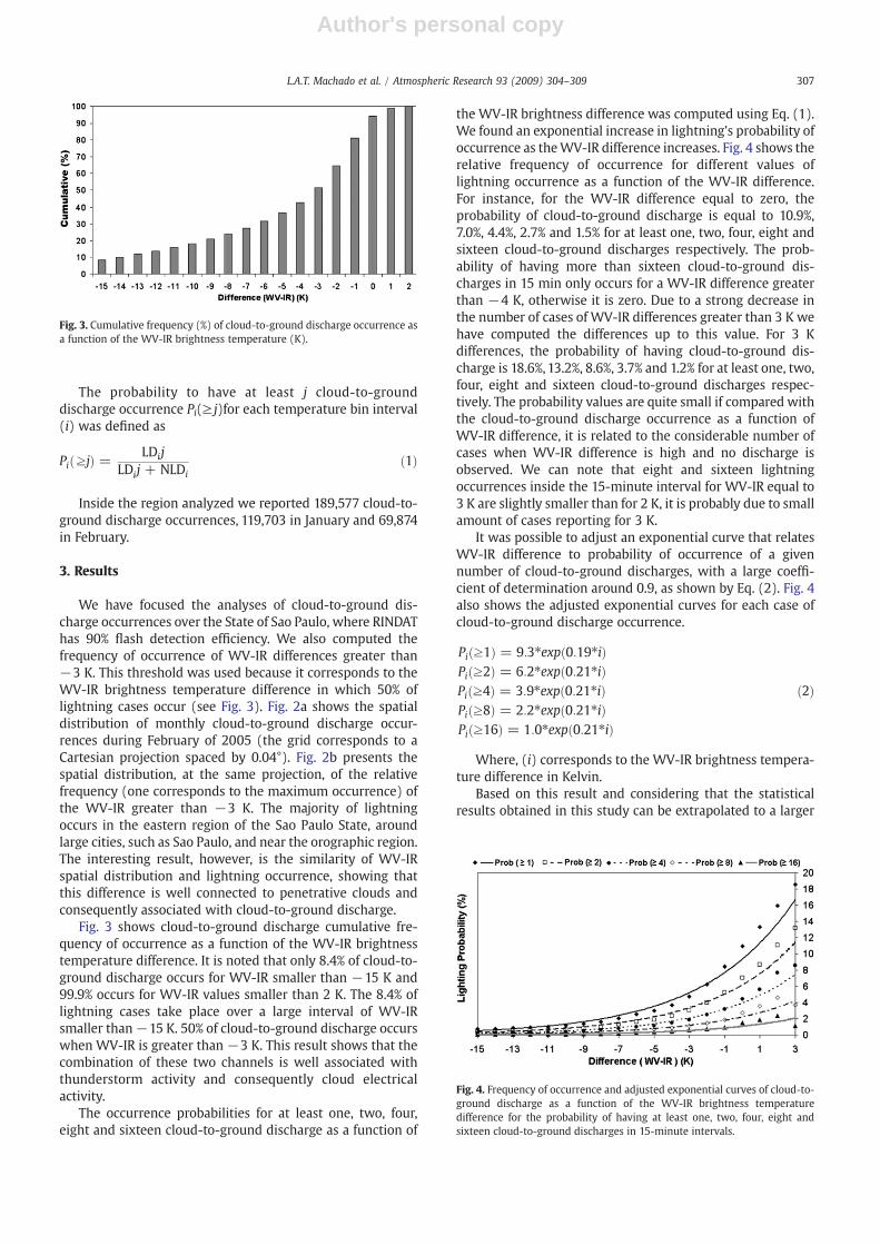
Fig. 3 shows cloud-to-ground discharge cumulative fre-quency of occurrence as a function of the WV-IR brightnesstemperature difference. It is noted that only 8.4% of cloud-to-ground discharge occurs for WV-IR smaller than −15 K and99.9% occurs for WV-IR values smaller than 2 K. The 8.4% oflightning cases take place over a large interval of WV-IRsmaller than−15 K. 50% of cloud-to-ground discharge occurswhen WV-IR is greater than −3 K. This result shows that thecombination of these two channels is well associated withthunderstorm activity and consequently cloud electricalactivity.
The occurrence probabilities for at least one, two, four,eight and sixteen cloud-to-ground discharge as a function of
the WV-IR brightness difference was computed using Eq. (1).We found an exponential increase in lightning's probability ofoccurrence as theWV-IR difference increases. Fig. 4 shows therelative frequency of occurrence for different values oflightning occurrence as a function of the WV-IR difference.For instance, for the WV-IR difference equal to zero, theprobability of cloud-to-ground discharge is equal to 10.9%,7.0%, 4.4%, 2.7% and 1.5% for at least one, two, four, eight andsixteen cloud-to-ground discharges respectively. The prob-ability of having more than sixteen cloud-to-ground dis-charges in 15 min only occurs for a WV-IR difference greaterthan −4 K, otherwise it is zero. Due to a strong decrease inthe number of cases of WV-IR differences greater than 3 K wehave computed the differences up to this value. For 3 Kdifferences, the probability of having cloud-to-ground dis-charge is 18.6%, 13.2%, 8.6%, 3.7% and 1.2% for at least one, two,four, eight and sixteen cloud-to-ground discharges respec-tively. The probability values are quite small if compared withthe cloud-to-ground discharge occurrence as a function ofWV-IR difference, it is related to the considerable number ofcases when WV-IR difference is high and no discharge isobserved. We can note that eight and sixteen lightningoccurrences inside the 15-minute interval for WV-IR equal to3 K are slightly smaller than for 2 K, it is probably due to smallamount of cases reporting for 3 K.
It was possible to adjust an exponential curve that relatesWV-IR difference to probability of occurrence of a givennumber of cloud-to-ground discharges, with a large coeffi-cient of determination around 0.9, as shown by Eq. (2). Fig. 4also shows the adjusted exponential curves for each case ofcloud-to-ground discharge occurrence.
Pi z1ð Þ = 9:3⁎exp 0:19⁎ið ÞPi z2ð Þ = 6:2⁎exp 0:21⁎ið ÞPi z4ð Þ = 3:9⁎exp 0:21⁎ið ÞPi z8ð Þ = 2:2⁎exp 0:21⁎ið ÞPi z16ð Þ = 1:0⁎exp 0:21⁎ið Þ
ð2Þ
Where, (i) corresponds to the WV-IR brightness tempera-ture difference in Kelvin.
Based on this result and considering that the statisticalresults obtained in this study can be extrapolated to a larger
Fig. 3. Cumulative frequency (%) of cloud-to-ground discharge occurrence asa function of the WV-IR brightness temperature (K).
Fig. 4. Frequency of occurrence and adjusted exponential curves of cloud-to-ground discharge as a function of the WV-IR brightness temperaturedifference for the probability of having at least one, two, four, eight andsixteen cloud-to-ground discharges in 15-minute intervals.
307L.A.T. Machado et al. / Atmospheric Research 93 (2009) 304–309

Author's personal copy
region, we estimate the probability of occurrence of cloud-to-ground discharge for all continental South America. But theseremain to be validated; the verification of these assertions canonly be evaluated when the RINDAT network has beenimproved with more sensors covering the other regions.Fig. 5 shows an example of the operational product, usingGOES 12 images and the number of cloud-to-grounddischarges per pixel in 15-minute intervals reported by theRINDAT network for the same time.We can note the similarityof the results even outside the region of large detectionefficiency. For this case shown in Fig. 5 we have computed deprobability of detection and false alarm. There were 7319 pix-els with at least one cloud-to-ground discharge, 85.8% ofthese pixels had WV-IRN0 K, and the 14.2% remaining of thepixels hadWV-IRb0. The probability of detection is very high,however, the false alarm rate is also very high, this is thereason for the probability to have at least one cloud-to-ground discharge forWV-IRN0 K is only 10.9% (see Fig. 4). Forthis case the false alarm rate for WV-IRN0 is 74.9% however,for WV-IRN5 K is only 14.8%. The considerable reduction inthe false alarm rate for larger WV-IR difference suggests thatthe lower WV-IR difference also includes the decay stage ofthe penetrative clouds when the updrafts is considerablyreduced but the cloud top still remain penetrative.
4. Conclusions
This study combines water vapor and infrared windowchannels to detect cloud-to-ground discharges. The WV-IRbrightness temperature difference can be used as a proxy for
deep convection.Wehave found that values greater than−15Kare associatedwith penetrative cloudswith potential for cloud-to-ground discharge activity. As the brightness temperaturedifference increases, the probability of lightning increases.These differences are also associated with the probability tohave a specific number of cloud-to-grounddischarges per pixel.For instance, if this difference is equal to zero, the probability ofhaving at least one cloud-to-ground discharge is 10.9%, 7.0% fortwo, 4.4% for four, 2.7% for eight and 1.5% for sixteen cloud-to-ground discharges. The probability of cloud-to-ground dis-charge can be expressed as an exponential function of theWV-IR brightness temperature difference.
The physical process behind these results is that WV-IRvalues greater than −15 K are associated with deepconvective clouds close to the tropopause or penetratingstorm tops in the stratosphere (overshooting clouds). Thus,these clouds contain large amounts of ice and highlyextended, therefore having a considerable potential for stronglightning activity. The probability of cloud-to-ground dis-charge as a function of the WV-IR difference is a combinationof a high probability of detection and false alarm rate. Furtherstudies should be made to investigate if additional informa-tion about cloud life stage can reduce the false alarm rate.
Based on these results it is possible to estimate theprobability of cloud-to-ground discharge using GOES imagesover South America over the region not covered by theRINDAT network. This result should be tested over othercontinental regions to determine if the statistical resultsobtained over this region can be extrapolated to all othercontinental regions and seasons.
Fig. 5. a) Probability of lightning occurrence for November 6th 2006 at 03:30 GMT. b) Number of cloud-to-ground discharges per pixel 7.5 min before and after03:30 GMT on the same day.
308 L.A.T. Machado et al. / Atmospheric Research 93 (2009) 304–309

Author's personal copy
Acknowledgements
We would like to thank RINDAT for providing the repro-cessed data and NOAA for providing GOES satellite images. Weacknowledge the review comments.
References
Abdoulaev, S., Marques, V.S., Pinheiro, F.M.A., Martinez, E.F.A., Lenskaia, O.,2001. Analysis of mesoscale system using cloud-to-ground flash data.Braz. J. Geophys. 19 (1), 75–95.
Adler, R.F., Mack, R.A., 1986. Thunderstorm cloud top dynamics as inferred fromsatellite observations and a cloud top parcel model. J. Atmos. Sci. 43 (18),1945–1960.
Baker, M.B., Christian, H.J., Latham, J., 1995. A computational study of therelationships linking lightning frequency and other thundercloudparameters. Q. J. R. Meteorol. Soc. 121, 1525–1548.
Fritz, S., Laszlo, I., 1993. Detection of water vapor in the stratosphere over veryhigh clouds in the tropics. J. Geophys. Res. 98 (D12), 22959–22967.
Heymsfield, A.J., Miloshevich, L.M., 1993. Homogenous ice nucleation andsupercooled liquid water in orographic wave clouds. J. Atmos. Sci. 50,2335–2353.
Kurino, T., 1997. A satellite infrared technique for estimating “Deep/Shallow”
precipitation. Adv. Space Res. 19 (3), 511–514.
MacGorman, D.R., Rust, W.D., 1998. The Electrical Nature of Storms. OxfordUniversity Press, New York.
Medaglia, C.M., Adamo, C., Formenton, M., Piccolo, F., 2005. Nowcasting ofconvective cells over Italian Peninsula. Adv. Geoscie. 2, 173–176.
Petersen, W.A., Rutledge, S.A., 1998. On the relationships between cloud-to-ground lightning and convective rainfall. J. Geophys. Res. Atmos.103 (D12),14025–14040.
Pinto Jr., O., 2003. The Brazilian Lightning Detection Network: A HistoricalBackground and Future Perspectives, Proceedings of VII InternationalSymposium on Lightning Protection (SIPDA). Curitiba, Brazil.
Pinto Jr., O., Saba, M.M.F., Pinto, I.R.C.A., Tavares, F.S.S., Solorzano, N.N.,Naccarato, K.P., Taylor, M., Pautet, P.D., Holzworth, R.H., 2004. Thunder-storm and lightning characteristics associated with sprites in Brazil.Geophys. Res. Lett. 31 (13), 13103–13106.
Reudenbach, C., Heinemann, G., Heuel, E., Bendix, J., Winiger, M., 2001.Investigation of summertime convective rainfall in Western Europebased on a synergy of remote sensing data and numerical models.Meteor. Atmosph. Phys. 76, 23–41.
Schmetz, J., Tjemkes, S.A., Gube, M., Van de Berg, L., 1997. Monitoring deepconvection and convective overshooting. Adv. Space Res. 19 (3), 433–441.
Stevak, M., Rabin, R.M., Wang, P.K., 2007. Contribution of the MODISinstrument to observations of deep convective storms and stratosphericmoisture detection in GOES and MSG imagery. Atmos. Res. 83, 505–518.
Wang, P.K., 2007. The thermodynamic structure atop a penetratingconvective thunderstorm. Atmos. Res. 83, 254–262.
309L.A.T. Machado et al. / Atmospheric Research 93 (2009) 304–309