AUSTRALIAN NOTICES TO MARINERS to Mariners/2017...This edition of Notices to Mariners includes all...
33
AUSTRALIAN NOTICES TO MARINERS Notices 1004 - 1053 The Hydrographer and Staff of the Australian Hydrographic Service wish all users of Australian Navigational Products a Merry Christmas, a Happy New Year and safe, successful voyages in 2018. Published fortnightly by the Australian Hydrographic Service Australian Notices to Mariners are the authority for correcting charts and publications published by the Australian Hydrographic Service covering Australia, Papua New Guinea, Solomon Islands, Australian Antarctic Territory and Timor-Leste. Commodore B.K. BRACE RAN Hydrographer of Australia SECTIONS. I. Australian Notices to Mariners, including blocks and notes. II. Hydrographic Reports. III. Navigational Warnings. SUPPLEMENTS. I. Tracings II. Cumulative List of Australian Notices to Mariners. III. Cumulative List of Temporary and Preliminary Australian Notices to Mariners. IV. Temporary and Preliminary Notices in force. V. Amendments to Admiralty List of Lights and Fog Signals (Vol K), Radio Signals (NP 281(2), 282, 283(2), 285, 286(4)) and Sailing Directions (NP 9, 13, 14, 15, 33, 34, 35, 36, 39, 44, 51, 60, 61, 62, 100, 136). © Commonwealth of Australia 2017 This work is copyright. Apart from any use permitted under the Copyright Act 1968, no part may be reproduced by any process, adapted, communicated or commercially exploited without prior written permission from The Commonwealth represented by the Australian Hydrographic Service. 1 December 2017 Edition 24
-
Upload
truongkhue -
Category
Documents
-
view
230 -
download
1
Transcript of AUSTRALIAN NOTICES TO MARINERS to Mariners/2017...This edition of Notices to Mariners includes all...

AUSTRALIANNOTICES TO MARINERS
Notices 1004 - 1053The Hydrographer and Staff of the Australian Hydrographic Service
wish all users of Australian Navigational Products a Merry Christmas,a Happy New Year and safe, successful voyages in 2018.
Published fortnightly by the Australian Hydrographic Service
Australian Notices to Mariners are the authority for correcting charts and publications published by theAustralian Hydrographic Service covering Australia, Papua New Guinea, Solomon Islands, AustralianAntarctic Territory and Timor-Leste.
Commodore B.K. BRACE RANHydrographer of Australia
SECTIONS.
I. Australian Notices to Mariners, including blocks and notes.II. Hydrographic Reports.III. Navigational Warnings.
SUPPLEMENTS.
I. TracingsII. Cumulative List of Australian Notices to Mariners.III. Cumulative List of Temporary and Preliminary Australian Notices to
Mariners.IV. Temporary and Preliminary Notices in force.V. Amendments to Admiralty List of Lights and Fog Signals (Vol K),
Radio Signals (NP 281(2), 282, 283(2), 285, 286(4)) and SailingDirections (NP 9, 13, 14, 15, 33, 34, 35, 36, 39, 44, 51, 60, 61, 62, 100, 136).
© Commonwealth of Australia 2017
This work is copyright. Apart from any use permitted under the Copyright Act 1968, no part may bereproduced by any process, adapted, communicated or commercially exploited without prior writtenpermission from The Commonwealth represented by the Australian Hydrographic Service.
1 December 2017 Edition 24
Australian Hydrographic Service
Text in blue contains links to relevant information. Click on the text to navigate to or execute linked information.

AHP 18
IMPORTANT NOTICE
This edition of Notices to Mariners includes all significant information affecting AHS products which theAHS has become aware of since the last edition. All reasonable efforts have been made to ensure theaccuracy and completeness of the information, including third party information, on which these updatesare based. The AHS regards third parties from which it receives information as reliable, however theAHS cannot verify all such information and errors may therefore exist. The AHS does not accept liabilityfor errors in third party information.
GENERAL INSTRUCTIONS
The substance of these notices should be inserted on the charts affected.
Bearings are referred to the true compass and are reckoned clockwise from North; those relating tolights are given as seen by an observer from seaward. Positions quoted in notices relate to WGS84 which is the horizontal datum for all charts produced by theAustralian Hydrographic Service.The range quoted for a light is its nominal range. Depths are with reference to the chart datum of each chart. Heights are above mean high water springsor mean higher high water, as appropriate.
The capital letter (P) or (T) after the number of any notice denotes a preliminary or temporary noticerespectively, which are contained separately at the end of the permanent notices.
REPORTING OF DANGERS
Mariners are particularly requested to notify the AUSTRALIAN HYDROGRAPHIC SERVICE, LockedBag 8801 Wollongong, NSW 2500 (Fax 02-4223 6599, e-mail [email protected] or,alternatively by filling in and submitting the Hydrographic Notes forms located on the web site –www.hydro.gov.au), immediately on the discovery of new dangers or suspected dangers to navigation. For changes or defects in aids to navigation notify AusSAR (Fax 02-6230 6868 or [email protected]).
AUTHORISED USECopies of Australian notices are available free of charge from the Australian Hydrographic Service(AHS) website (www.hydro.gov.au) and through the eNotices (email) service(www.hydro.gov.au/enotices/enotices.htm).
Individual Notices may be copied for the purpose of inserting Notice substance on official charts andpublications. Paper copies may be printed by chart agents and distributed to customers on a costrecovery basis. Participating chart agents are listed on the AHS website as providing a 'Paper Noticesto Mariners’ service (www.hydro.gov.au/webapps/jsp/agents/agents-list.jsp). Copies of the noticesmay not be sold for profit without prior written agreement.

I
1 December 2017 3
NUMERICAL INDEX OF NOTICES TO MARINERS
Edition No 24
Notices Aus Chart, INT Chart, ENC Cell, AHP, BA Pubs1004 Products - New Charts, New Editions, Withdrawn Charts1005 Amendment to Seafarers Handbook for Australian Waters - 4th Edition1006 Aus 1981007 Aus 2021008 Aus 200, 202, 2031009 Aus 1941010 Aus 244, 245, 2461011 Aus 2301012 Aus 258, 8291013 Aus 3671014 Aus 293, 2991015 Aus 321016 Aus 1141017 Aus 58, 601018 Aus 721019 Aus 9201020 Aus 4603, 4722, INT 603, 7221021 Aus 4708, 4723, INT 708, 7231022 Aus 1271023 Aus 143, 1581024 Aus 153, 1571025 Aus 173, 795, 4644, INT 6441026 Aus 8001027 Aus 1681028(T) Aus 2221029(T) Aus 191, 489, 808, 4643, INT 6431030(T) Aus 489, 809, 810, 4643, INT 6431031(T) Aus 200, 2021032(T) Aus 200, 2021033(T) Aus 194, 1951034(T) Aus 826, 8271035(T) Aus 2401036(T) Aus 240, 815, 8171037(T) Aus 2351038(T) Aus 248, 367, 820, 8221039(T) Aus 2561040(T) Aus 111, 112, 117, 7541041(T) Aus 1191042(T) Aus 314, 319, 4721, 4722, INT 721, 7221043(T) Aus 4708, 4723, INT 708, 7231044(T) Aus 1431045(T) Aus 144, 150, 154, 1581046(T) Aus 153, 1571047(T) Aus 1571048(T) Aus 144, 1581049(T) Aus 1411050(T) Aus 1571051(T) Aus 1571052(T) Aus 143, 7881053(T) Aus 177, 792

I
1 December 2017 4
NUMERICAL INDEX OF CHARTS AFFECTED
Edition No 24
Aus Chart Notices Aus Chart NoticesAus 32 1015 Aus 820 1038(T)Aus 58 1017 Aus 822 1038(T)Aus 60 1017 Aus 826 1034(T)Aus 72 1018 Aus 827 1034(T)Aus 111 1040(T) Aus 829 1012Aus 112 1040(T) Aus 920 1019Aus 114 1016 Aus 4603 1020Aus 117 1040(T) Aus 4643 1029(T), 1030(T)Aus 119 1041(T) Aus 4644 1025Aus 127 1022 Aus 4708 1021, 1043(T)Aus 141 1049(T) Aus 4721 1042(T)Aus 143 1023, 1044(T), 1052(T) Aus 4722 1020, 1042(T)Aus 144 1045(T), 1048(T) Aus 4723 1021, 1043(T)Aus 150 1045(T)Aus 153 1024, 1046(T)Aus 154 1045(T)Aus 157 1024, 1046(T), 1047(T), 1050(T),
1051(T)Aus 158 1023, 1045(T), 1048(T)Aus 168 1027 INT Chart NoticesAus 173 1025 INT 603 1020Aus 177 1053(T) INT 643 1029(T), 1030(T)Aus 191 1029(T) INT 644 1025Aus 194 1009, 1033(T) INT 708 1021, 1043(T)Aus 195 1033(T) INT 721 1042(T)Aus 198 1006 INT 722 1020, 1042(T)Aus 200 1008, 1031(T), 1032(T) INT 723 1021, 1043(T)Aus 202 1007, 1008, 1031(T), 1032(T)Aus 203 1008Aus 222 1028(T)Aus 230 1011Aus 235 1037(T)Aus 240 1035(T), 1036(T)Aus 244 1010Aus 245 1010Aus 246 1010Aus 248 1038(T)Aus 256 1039(T)Aus 258 1012Aus 293 1014Aus 299 1014Aus 314 1042(T)Aus 319 1042(T)Aus 367 1013, 1038(T)Aus 489 1029(T), 1030(T)Aus 754 1040(T)Aus 788 1052(T)Aus 792 1053(T)Aus 795 1025Aus 800 1026Aus 808 1029(T)Aus 809 1030(T)Aus 810 1030(T)Aus 815 1036(T)Aus 817 1036(T)

I
1 December 2017 5
1004 AUSTRALIA - Products - New Charts, New Editions, Withdrawn ChartsUKHO , Australian Hydrographic Service
New ChartsChart Title and Geographical limits Scale Publication Date RemarksNIL
New Electronic Navigation Chart (Aus ENC)Cell Name Title Publication Date RemarksNIL
New Editions and Withdrawn ChartsChart Title Scale Publication Date RemarksNIL
Admiralty publicationNP No Title Date RemarksNP281(2) Admiralty List of Radio Signals.
Maritime Radio Stations.The Americas, Far East and Oceania.
30/11/2017 The 2016/17 Edition is cancelled.
NP33 Philippine Islands Pilot. Sixth Edition 2017. 07/12/2017 The NP33 Fifth Edition 2014 is cancelled.
Chart permanently withdrawnCharts listed above as withdrawn no longer meet chart carriage requirements and should be marked as "superseded" andreplaced with the new chart/ new edition listed prior to passage through the area covered by the new chart.
When placing orders with a chart agent between notice of forthcoming edition and its publication, mariners should advisewhether their order pertains to the current edition or the new edition.
For further details refer to the AHS website at www.hydro.gov.au for new edition and new chart stock arrival information.
1005 AUSTRALIA - Product - Amendment to Seafarers Handbook for Australian Waters - 4th EditionDepartment of Agriculture and Water Resources , Australian Bureau of Meteorology , Royal Australian Navy
Chapter 9 – Meteorological Broadcasts - paragraph 9.4 page 151
Replace table with accompanying block
Chapter 9 – Marine Radio - Voice - paragraph 9.4.1 page 151
Replace table with accompanying block
Chapter 9 – Forecasts and Warnings - pages 154 to 155
Replace with accompanying pages
Chapter 11 – MARs reporting - pages 209 to 213
Replace with accompanying pages
Chapter 11 – Torres Strait Quarantine Zone - page 221
Replace with accompanying page
Chapter 11 – Australian Defence Force contacts - paragraph 11.11.7 - page 231
Replace table with accompanying block

I
1 December 2017 6
1006 AUSTRALIA - NEW SOUTH WALES - Botany Bay - Kogarah Bay - Light beaconNSW Roads and Maritime Services
Aus 198 [198/2017]Insert starboard lateral light beacon, Fl.G.3s, without topmark 34° 00'.067 S 151° 07'.257 E
1007 AUSTRALIA - NEW SOUTH WALES - Port Jackson - Mort Bay - DepthsPort Authority of New South Wales
Aus 202 [954/2017]Insert contour, between 33° 51'.349 S
33° 51'.365 S33° 51'.368 S33° 51'.356 S
151° 11'.287 E151° 11'.312 E151° 11'.361 E151° 11'.390 E
depth, 13m, semi enclosed by contour to N 33° 51'.097 S 151° 11'.427 E
Replace depth, 39m, with depth, 13m 33° 51'.36 S 151° 11'.29 E
Delete contour, between 33° 51'.40 S33° 51'.36 S
151° 11'.36 E151° 11'.39 E

I
1 December 2017 7
1008 AUSTRALIA - NEW SOUTH WALES - Port Jackson - Clarkes Point to Lane Cove River - DepthsPort Authority of New South Wales
Aus 200 [770/2017]Insert depth, 18m, and extend contour N to enclose 33° 49'.829 S 151° 09'.065 E
depth, 14m, and extend contour SW to enclose 33° 50'.077 S 151° 09'.851 Econtour, between 33° 50'.597 S
33° 50'.560 S33° 50'.503 S33° 50'.510 S
151° 10'.580 E151° 10'.590 E151° 10'.554 E151° 10'.640 E
Delete depth, 21m 33° 49'.83 S 151° 09'.08 Edepth, 29m 33° 50'.13 S 151° 09'.86 Econtour, between 33° 50'.60 S
33° 50'.42 S33° 50'.51 S
151° 10'.58 E151° 10'.48 E151° 10'.64 E
Aus 202 [1007/2017]Insert depth, 22m 33° 50'.130 S 151° 09'.843 E
depth, 14m, enclosed by contour 33° 50'.077 S 151° 09'.851 Edepth, 14m, and extend contour S to enclose 33° 50'.170 S 151° 10'.110 Econtour, between 33° 50'.597 S
33° 50'.560 S33° 50'.503 S33° 50'.510 S
151° 10'.580 E151° 10'.590 E151° 10'.554 E151° 10'.640 E
depth, 2m, enclosed by danger circle, with legend Obstn 33° 50'.357 S 151° 10'.788 E
Delete depth, 29m 33° 50'.13 S 151° 09'.86 Edepth, 07m 33° 50'.16 S 151° 10'.11 Econtour, between 33° 50'.60 S
33° 50'.42 S33° 50'.51 S
151° 10'.58 E151° 10'.48 E151° 10'.64 E
depth, 112m 33° 50'.50 S 151° 10'.57 Edepth, 3m 33° 50'.08 S 151° 09'.87 E
Aus 203 [813/2017]Insert depth, 18m, and extend contour N to enclose 33° 49'.829 S 151° 09'.065 E
depth, 22m 33° 50'.130 S 151° 09'.843 Edepth, 14m, enclosed by contour 33° 50'.077 S 151° 09'.851 Edepth, 14m, and extend contour S to enclose 33° 50'.170 S 151° 10'.110 E
Delete depth, 21m 33° 49'.83 S 151° 09'.08 Edepth, 29m 33° 50'.13 S 151° 09'.86 E
1009 AUSTRALIA - NEW SOUTH WALES - Port Kembla - DepthsPort Authority of New South Wales
Aus 194 [771/2017]Insert accompanying block 34° 27'.15 S 150° 53'.70 E
1010 AUSTRALIA - QUEENSLAND - Gladstone - Golding Channel - NavaidsMaritime Safety Queensland
Aus 244 [775/2017]Amend light to, F.Bu (F Day) 23° 51'.27 S 151° 18'.74 E
Aus 245 [815/2017]Replace beacon, with light beacon, F.Bu & Fl.R.4s (F Day), with port lateral
topmark 23° 51'.87 S 151° 19'.80 E
Aus 246 [775/2017]Replace beacon, with light beacon, F.Bu & Fl.R.4s (F Day), with port lateral
topmark 23° 51'.87 S 151° 19'.80 E
I
1 December 2017 8
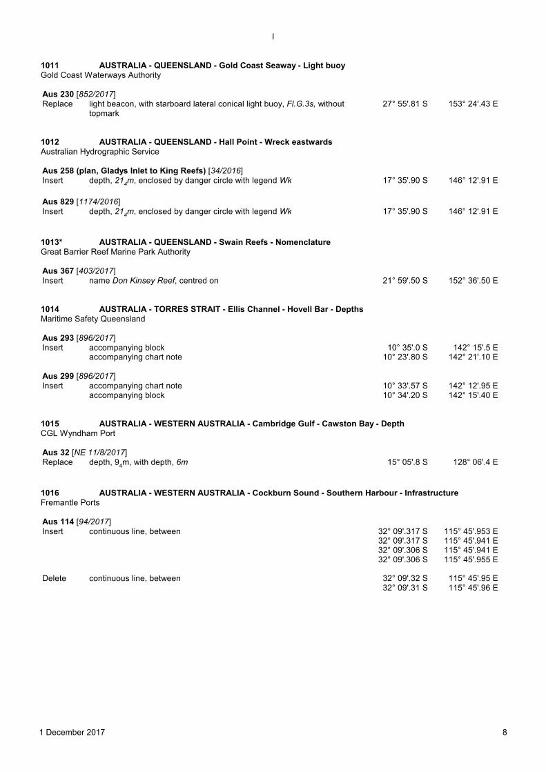
1011 AUSTRALIA - QUEENSLAND - Gold Coast Seaway - Light buoyGold Coast Waterways Authority
Aus 230 [852/2017]Replace light beacon, with starboard lateral conical light buoy, Fl.G.3s, without
topmark 27° 55'.81 S 153° 24'.43 E
1012 AUSTRALIA - QUEENSLAND - Hall Point - Wreck eastwardsAustralian Hydrographic Service
Aus 258 (plan, Gladys Inlet to King Reefs) [34/2016]Insert depth, 214m, enclosed by danger circle with legend Wk 17° 35'.90 S 146° 12'.91 E
Aus 829 [1174/2016]Insert depth, 214m, enclosed by danger circle with legend Wk 17° 35'.90 S 146° 12'.91 E
1013* AUSTRALIA - QUEENSLAND - Swain Reefs - NomenclatureGreat Barrier Reef Marine Park Authority
Aus 367 [403/2017]Insert name Don Kinsey Reef, centred on 21° 59'.50 S 152° 36'.50 E
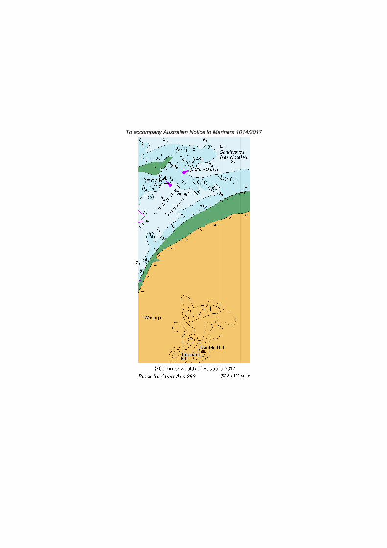
1014 AUSTRALIA - TORRES STRAIT - Ellis Channel - Hovell Bar - DepthsMaritime Safety Queensland
Aus 293 [896/2017]Insert accompanying block 10° 35'.0 S 142° 15'.5 E
accompanying chart note 10° 23'.80 S 142° 21'.10 E
Aus 299 [896/2017]Insert accompanying chart note 10° 33'.57 S 142° 12'.95 E
accompanying block 10° 34'.20 S 142° 15'.40 E
1015 AUSTRALIA - WESTERN AUSTRALIA - Cambridge Gulf - Cawston Bay - DepthCGL Wyndham Port
Aus 32 [NE 11/8/2017]Replace depth, 94m, with depth, 6m 15° 05'.8 S 128° 06'.4 E
1016 AUSTRALIA - WESTERN AUSTRALIA - Cockburn Sound - Southern Harbour - InfrastructureFremantle Ports
Aus 114 [94/2017]Insert continuous line, between 32° 09'.317 S
32° 09'.317 S32° 09'.306 S32° 09'.306 S
115° 45'.953 E115° 45'.941 E115° 45'.941 E115° 45'.955 E
Delete continuous line, between 32° 09'.32 S32° 09'.31 S
115° 45'.95 E115° 45'.96 E

I
1 December 2017 9
1017 AUSTRALIA - WESTERN AUSTRALIA - Dampier - Pilot boarding placePilbara Ports Authority Notice D15/2017
Aus 58 [362/2017]Move pilot boarding place
to20° 28'.60 S
20° 28'.600 S116° 44'.25 E
116° 44'.300 Epilot boarding place to
20° 38'.50 S20° 38'.500 S
116° 38'.98 E116° 39'.000 E
Aus 60 [780/2017]Move pilot boarding place
to20° 38'.50 S
20° 38'.500 S116° 38'.98 E
116° 39'.000 E
1018 AUSTRALIA - WESTERN AUSTRALIA - Point Murat - Depths; infrastructureAustralian Hydrographic Service
Aus 72 (plan, Mauds Landing) [604/2017]Insert accompanying block B 23° 08'.70 S 113° 48'.80 E
Aus 72 (plan, Point Murat Wharf) [604/2017]Insert accompanying block A 21° 49'.05 S 114° 11'.70 E
1019 INDIAN OCEAN - Christmas Island - Flying Fish Cove - Mooring buoysLINX Cargo Care Group
Aus 920 (plan, Flying Fish Cove) [551/2016]Insert accompanying block 10° 25'.6 S 105° 40'.1 E
Delete lit radio tower 10° 25'.99 S 105° 41'.07 Elit radio tower 10° 25'.99 S 105° 41'.11 E
1020 INDIAN OCEAN - North Australian Basin - Light buoy movedAustralian Bureau of Meteorology
Aus 4603 (INT 603) [821/2017]Move light buoy
to15° 01'.4 S15° 01'.2 S
117° 56'.7 E118° 04'.4 E
Aus 4722 (INT 722) [731/2017]Move light buoy
to15° 01'.4 S15° 01'.2 S
117° 56'.7 E118° 04'.4 E
1021 INDIAN OCEAN - Roo Rise - Light buoyAustralian Bureau of Meteorology
Aus 4708 (INT 708) [696/2017]Insert special conical light buoy, Fl.Y.2s, without topmark 14° 02'.8 S 110° 01'.7 E
Delete light buoy 13° 59'.3 S 110° 00'.3 E
Aus 4723 (INT 723) [968/2017]Insert special conical light buoy, Fl.Y.2s, without topmark 14° 02'.8 S 110° 01'.7 E
Delete light buoy 13° 59'.3 S 110° 00'.3 E
1022 AUSTRALIA - SOUTH AUSTRALIA - Encounter Bay - BeaconDepartment for Transport, Energy and Infrastructure SA
Aus 127 (plan, King Head to Port Elliot) [971/2017]Insert beacon, with special topmark 35° 34'.21 S 138° 36'.63 E

I
1 December 2017 10
1023 AUSTRALIA - VICTORIA - Port Phillip - Pinnace Channel - Light buoysParks Victoria Notice 292/2017
Aus 143 [906/2017]Insert special cylindrical light buoy, Fl(4)Y.12s, with topmark 38° 15'.35 S 144° 50'.70 E
special cylindrical light buoy, Fl(4)Y.12s, with topmark 38° 15'.69 S 144° 49'.58 E
Aus 158 [866/2017]Insert special cylindrical light buoy, Fl(4)Y.12s, with topmark 38° 15'.347 S 144° 50'.697 E
special cylindrical light buoy, Fl(4)Y.12s, with topmark 38° 15'.693 S 144° 49'.581 E
1024 AUSTRALIA - VICTORIA - Port Phillip - Corio Bay - Light buoysFormer Notice - 238(T)/2017 is cancelledParks Victoria Notice 117/2017, Notice 295/2017
Aus 153 [169/2017]Insert special conical light buoy, Fl.Y.5s RGYC CB3, with topmark 38° 07'.601 S 144° 23'.549 E
special conical light buoy, Fl.Y.5s RGYC CB4, with topmark 38° 07'.725 S 144° 22'.159 Especial conical light buoy, Fl.Y.5s RGYC CB5, with topmark 38° 06'.211 S 144° 22'.940 E
Amend light buoy to, Fl.Y.5s RGYC CB6 38° 06'.50 S 144° 24'.00 Elight buoy to, Fl.Y.5s RGYC CB1 38° 05'.56 S 144° 24'.20 Elight buoy to, Fl.Y.5s RGYC CB2 38° 07'.62 S 144° 24'.18 E
Delete light buoy 38° 08'.46 S 144° 22'.87 Elight buoy 38° 08'.52 S 144° 22'.15 Elight buoy 38° 06'.23 S 144° 22'.76 E
Aus 157 [827/2017]Insert special conical light buoy, Fl.Y.5s RGYC CB3, with topmark 38° 07'.601 S 144° 23'.549 E
special conical light buoy, Fl.Y.5s RGYC CB4, with topmark 38° 07'.725 S 144° 22'.159 Especial conical light buoy, Fl.Y.5s RGYC CB5, with topmark 38° 06'.211 S 144° 22'.940 E
Amend light buoy to, Fl.Y.5s RGYC CB6 38° 06'.50 S 144° 24'.00 Elight buoy to, Fl.Y.5s RGYC CB1 38° 05'.56 S 144° 24'.20 Elight buoy to, Fl.Y.5s RGYC CB2 38° 07'.62 S 144° 24'.18 E
Delete light buoy 38° 08'.46 S 144° 22'.87 Elight buoy 38° 08'.52 S 144° 22'.15 Elight buoy 38° 06'.23 S 144° 22'.76 E
1025 AUSTRALIA - TASMANIA - Bruny Island - Cape Bruny - Light range amendedAustralian Maritime Safety Authority
Aus 173 [788/2017]Amend light range to, 15M 43° 29'.6 S 147° 08'.8 E
Aus 795 [867/2017]Amend light range to, 15M 43° 29'.6 S 147° 08'.8 E
Aus 4644 (INT 644) [867/2017]Amend light range to, 15M 43° 29'.6 S 147° 08'.8 E
1026 AUSTRALIA - TASMANIA - Furneaux Group - Isabella Island - DepthsA Phillips
Aus 800 [285/2017]Insert depth, 45m, enclosed by contour, with legend Rep (2017) 40° 08'.52 S 147° 56'.72 E

I
1 December 2017 11
1027 AUSTRALIA - TASMANIA - River Tamar - Long Reach to Haystack Point - NavaidsAustralian Hydrographic Service
Aus 168 [514/2017]Insert beacon 41° 11'.467 S 146° 55'.053 E
Amend light beacon to, Q(4) R.6s No18 41° 20'.40 S 147° 04'.80 Elight beacon to, Fl.R.3s No20 41° 19'.84 S 147° 03'.74 Elight to, VQ(3)G.5s 41° 20'.76 S 147° 04'.60 Elight beacon to, Fl.G.3s 2M No1 41° 08'.59 S 146° 53'.46 Ebearing to, 144·2° 41° 08'.70 S 146° 53'.92 Elight beacon to, F.R.3m 3M 41° 10'.85 S 146° 56'.73 E
Delete beacon 41° 11'.48 S 146° 55'.01 E
Aus 168 (inset, Tamar Island to Launceston) [514/2017]Amend light beacon to, Fl.R.3s No16 41° 22'.28 S 147° 04'.90 E
bearing to, 339·7° 41° 24'.22 S 147° 06'.96 E
Delete beacon 41° 22'.59 S 147° 05'.45 E

I
1 December 2017 12
1028(T)/2017 AUSTRALIA - NEW SOUTH WALES - Clarence River - Yamba - Shoaling chartedFormer Notice - 823(P)/2016 is cancelledPort Authority of New South Wales
Cancel this notice on receipt.
Chart formerly affected - Aus 222
1029(T)/2017 AUSTRALIA - NEW SOUTH WALES - Kiama - Light range reducedNSW Roads and Maritime Services
The light, Fl(4) 20s 36m 16M (34° 40'.31 S 150° 51'.75 E), has been altered to Fl(4) 20s 36m 9M
Chart temporarily affected - Aus 191 - Aus 489 - Aus 808 - Aus 4643 (INT 643)
1030(T)/2017 AUSTRALIA - NEW SOUTH WALES - Newcastle - Live firingDepartment of Defence
Military exercise area Williamtown Air Weapons Range R574 will be activated for air to air live firing from 5 December to 7December 2017 in the airspace bounded by:
33° 09'.00 S 152° 06'.00 E thence on the minor arc of a circle of 25M radius centred on 32° 48'.00 S 151° 50'.00 E to 32°44'.50 S 152° 19'.50 E, 32° 36'.00 S 153° 24'.25 E, thence the minor arc of a circle of 80M radius centred on 32° 48'.00 S151° 50'.00 E to 33° 03'.00 S 153° 23'.00 E, 33° 17'.00S 153° 11'.00, 33° 25'.00 S 152° 18'.67, 33° 09'.00 S 152° 06'.00.
Mariners are advised to navigate with caution in the area.
Chart temporarily affected - Aus 489 - Aus 809 - Aus 810 - Aus 4643 (INT 643)
1031(T)/2017 AUSTRALIA - NEW SOUTH WALES - Port Jackson - Milsons Point - Harbour works completedFormer Notice - 325(T)/2017 is cancelledPort Authority of New South Wales
Cancel this notice on receipt.
Chart formerly affected - Aus 200 - Aus 202
1032(T)/2017 AUSTRALIA - NEW SOUTH WALES - Port Jackson - Glebe Island - Harbour works completedFormer Notice - 789(T)/2017 is cancelledPort Authority of New South Wales
Cancel this notice on receipt.
Chart formerly affected - Aus 200 - Aus 202
1033(T)/2017 AUSTRALIA - NEW SOUTH WALES - Port Kembla - Dredging operations completed; light restoredFormer Notice - 680(T)/2015 is cancelledPort Authority of New South Wales
Cancel this notice on receipt.
Chart formerly affected - Aus 194 - Aus 195
1034(T)/2017 AUSTRALIA - QUEENSLAND - Cape Bowling Green - Light buoy off station eastwardsFormer Notice - 912(T)/2014 is cancelledAustralian Institute of Marine Science
The isolated danger light buoy, Fl(2)5s (19° 18'.12 S 147° 37'.05 E), is off station; a special pillar light buoy, Fl(4).Y 19s,exists in position 19° 18'.06 S 147° 37'.23 E.
Chart temporarily affected - Aus 826 - Aus 827

I
1 December 2017 13
1035(T)/2017 AUSTRALIA - QUEENSLAND - Great Sandy Strait - Dream Island - Beacon destroyedMaritime Safety Queensland Notice 460(T)/2017
The starboard lateral beacon (25° 36'.82 S 152° 57'.47 E) has been destroyed; a starboard lateral buoy exists in situ.
Chart temporarily affected - Aus 240
1036(T)/2017 AUSTRALIA - QUEENSLAND - Inskip Point - Light unlitMaritime Safety Queensland Notice 461(T)/2017
The rear lead light, Iso.Bu.2s (25° 48'.67 S 153° 03'.81 E), is unlit.
Chart temporarily affected - Aus 240 - Aus 815 - Aus 817
1037(T)/2017 AUSTRALIA - QUEENSLAND - Mooloolaba - ShoalingFormer Notice - 873(T)/2017 is cancelledMaritime Safety Queensland Notice 479(T)/2017
A shoal patch exists from the end of the eastern breakwater (26° 40'.74 S 153° 07'.95 E) extending in a westerly directiontowards the centreline of the channel with least depths as follows:Postion Depth26° 40'.74 S 153° 07'.89 E 2.2m26° 40'.76 S 153° 07'.94 E 1.1m
Mariners are advised to navigate with caution in the area.
Chart temporarily affected - Aus 235
1038(T)/2017 AUSTRALIA - QUEENSLAND - Shoalwater Bay - Live firing completedFormer Notice - 801(T)/2017 is cancelledMaritime Safety Queensland Notice 310(T)/2017
Cancel this notice on receipt.
Chart formerly affected - Aus 248 - Aus 367 - Aus 820 - Aus 822
1039(T)/2017 AUSTRALIA - QUEENSLAND - Townsville - Sea Channel - Light buoy restoredFormer Notice - 988(T)/2017 is cancelledMaritime Safety Queensland Notice 476/2017
Cancel this notice on receipt.
Chart formerly affected - Aus 256
1040(T)/2017 AUSTRALIA - WESTERN AUSTRALIA - Direction Bank to Garden Island - Military exercise completedFormer Notice - 882(T)/2017 is cancelledDepartment of Defence
Cancel this notice on receipt.
Chart formerly affected - Aus 111 - Aus 112 - Aus 117 - Aus 754
1041(T)/2017 AUSTRALIA - WESTERN AUSTRALIA - Esperance - Bandy Creek Boat Harbour - Harbour workscompleted
Former Notice - 995(T)/2017 is cancelledDepartment of Transport WA Notice 121/2017
Cancel this notice on receipt.
Chart formerly affected - Aus 119

I
1 December 2017 14
1042(T)/2017 INDIAN OCEAN - Osborn Passage - Seismic surveyMV Polarcus Naila
MV Polarcus Naila, with a 9260m towed array, and support vessels Mermaid Searcher and Empress are conducting aseismic survey in an area bounded by the following positions:12° 30'.34 S 124° 50'.59 E12° 40'.35 S 124° 50'.58 E12° 40'.32 S 124° 45'.60 E12° 52'.25 S 124° 45'.58 E13° 18'.55 S 124° 25'.52 E12° 54'.70 S 123° 49'.55 E12° 43'.35 S 123° 49'.57 E12° 26'.69 S 124° 00'.14 E12° 04'.38 S 124° 25'.07 E11° 53'.38 S 124° 31'.83 E12° 14'.50 S 125° 00'.58 E12° 30'.35 S 125° 00'.61 E.
Vessels will display appropriate colours and shapes
Mariners are advised to navigate with caution in the area. 6M clearance requested.
Chart temporarily affected - Aus 314 - Aus 319 - Aus 4721 (INT 721) - Aus 4722 (INT 722)
1043(T)/2017 INDIAN OCEAN - Roo Rise - Light buoy recoveredFormer Notice - 885(T)/2017 is cancelledAustralian Bureau of Meteorology
Cancel this notice on receipt.
Chart formerly affected - Aus 4708 (INT 708) - Aus 4723 (INT 723)
1044(T)/2017 AUSTRALIA - VICTORIA - Patterson River - Light unlitParks Victoria Notice 307(T)/2017
The light, Fl(3) R.5s 5M (38° 04'.38 S 145° 07'.18 E), is unlit.
Chart temporarily affected - Aus 143
1045(T)/2017 AUSTRALIA - VICTORIA - Port Phillip - South Channel to Yarra River - Dredging operations completedFormer Notice - 886(T)/2017 is cancelledPort of Melbourne Corporation Notice 297/2017
Cancel this notice on receipt.
Chart formerly affected - Aus 144 - Aus 150 - Aus 154 - Aus 158
1046(T)/2017 AUSTRALIA - VICTORIA - Port Phillip - Corio Bay - DredgingVictorian Regional Channels Authority 298(T)/2017
The dredge Machiavelli with support vessels will be conducting dredging operations directly east of Corio Channel in thevicinity of temporary light buoy, F.Iso.G.3s No5, (38° 06'.20 S 144° 22'.68 E).
Vessels will display appropriate lights and shapes and monitor VHF Ch 12.
Spoil will be deposited in the spoil ground (38° 02'.95 S 144° 34'.00 E) northeast of Point Wilson.
Mariners are advised to navigate with caution in the area.
Chart temporarily affected - Aus 153 - Aus 157

I
1 December 2017 15
1047(T)/2017 AUSTRALIA - VICTORIA - Port Phillip - Bird Rock - Light beacon relitFormer Notice - 908(T)/2016 is cancelledParks Victoria Notice 305/2017
Cancel this notice on receipt.
Chart formerly affected - Aus 157
1048(T)/2017 AUSTRALIA - VICTORIA - Port Phillip - Port Lonsdale - Light beacon relitFormer Notice - 1002(T)/2016 is cancelledParks Victoria Notice 296/2017
Cancel this notice on receipt.
Chart formerly affected - Aus 144 - Aus 158
1049(T)/2017 AUSTRALIA - VICTORIA - Port Phillip - Port Fairy - Dredging operationsTransport Safety Victoria Notice 312(T)/2017
The dredge MSV 12085 is conducting dredging operations in the entrance to Port Fairy (38° 23'.35 S 142° 14'.95 E).
Mariners are advised to navigate with caution in the area.
Chart temporarily affected - Aus 141
1050(T)/2017 AUSTRALIA - VICTORIA - Port Phillip - Corio Bay - Light beacon relitFormer Notice - 1004(T)/2016 is cancelledParks Victoria Notice 314/2017
Cancel this notice on receipt.
Chart formerly affected - Aus 157
1051(T)/2017 AUSTRALIA - VICTORIA - Port Phillip - Wedge Point - Light buoy restoredFormer Notice - 488(T)/2017 is cancelledParks Victoria Notice 315/2017
Cancel this notice on receipt.
Chart formerly affected - Aus 157
1052(T)/2017 AUSTRALIA - VICTORIA - Torquay - Fish aggregating devicesVictorian Fisheries Authority
Five special light buoys, Fl.Y.5s, will be deployed between December and May in vicinity of position 38° 20'.01 S 144° 22'.43E.
Chart temporarily affected - Aus 143 - Aus 788
1053(T)/2017 AUSTRALIA - TASMANIA - Macquarie Harbour - King Point - Beacon establishedMaritime and Safety Tasmania Notice 147/2017
A beacon exists in position (42° 12'.62 S 145° 20'.45 E). This will be upgraded to a west cardinal beacon shortly.
Chart temporarily affected - Aus 177 - Aus 792

II
1 December 2017 16
HYDROGRAPHIC REPORTS
Locality Report Ship/Authority Observer
TAS-Isabella Island Depth SY Hetairos A Phillips

III
1 December 2017 17
NAVIGATION WARNINGS
The Australian Hydrographic Service will no longer compile Section III of the Australian Notices to Mariners. For the most up todate navigation warnings please refer to:
AMSA Navigation Warningshttp://amsa.gov.au/search-and-rescue/distress-and-safety-comms/msi/msi-email/index.asp
New Zealand Notices to Mariners (Navarea XIV warnings)http://www.linz.govt.nz/sea/maritime-safety/notices-mariners

To accompany Australian Notice to Mariners 1014/2017
SANDWAVESThe seabed in this area consists ofsandwaves which cause variations in actualdepth to those charted. If mariners areunsure of the condition of the seabed in aparticular area, local information should besought prior to crossing.
Note for chart Aus 293
To accompany Australian Notice to Mariners 1014/2017
SANDWAVESThe seabed in this area consists ofsandwaves which cause variations in actualdepth to those charted. If mariners areunsure of the condition of the seabed in aparticular area, local information should besought prior to crossing.
Note for chart Aus 299

Page 151
Page 151
Page 231
To accompany Australian Notice to Mariners 1005/2017

154
Australian Seafarers HandbookSeafarers Handbook for Australian Waters
Australian high seas forecast areas
9.4.2 Forecasts
Routine coastal waters forecasts1. Routine coastal waters forecasts and observation reports are for areas within 60 nautical miles of the coast.
They are generally issued twice a day with updates at other times if weather conditions change significantly from those forecasts. The BOM provides forecasts up to four days ahead.
High seas forecasts2. Routine High Seas Forecasts are issued twice daily for sea areas surrounding Australia. The Australian High
Seas areas extend from the coastline to the limits shown in the diagram below.
9.4.3 Warnings
1. Warnings are issued by the BOM under the following categories:
Warning Category Wind Strength
Strong Wind Warning: 26 - 33 knots
Gale Warning: 34 - 47 knots
Storm Force Wind Warning: 48 - 63 knots
Hurricane Force Wind Warning: >64 knots
Warnings for coastal waters2. Warnings for coastal waters are issued whenever strong winds, gales, storm force or hurricane force winds
are expected. Warnings are renewed every six hours.
Station Coastal Waters Areas
Broadcast Times
VMC: QLD, NSW, VIC, TAS, SA, NT
Every hour commencing 0000 EST
VMV: QLD Gulf, NT, WA, SA
Every hour commencing 0000 WST
180°
180°
170°E
170°E
160°E
160°E
150°E
150°E
140°E
140°E
130°E
130°E
120°E
120°E
110°E
110°E
100°E
100°E
90°E
90°E
80°E
80°E
0° 0°
10°S 10°S
20°S 20°S
30°S 30°S
40°S 40°S
50°S 50°S
Mercator projection standard parallel 22º 30' S
WESTERN
NORTH EASTERN
SOUTH EASTERN
NORTHERN
© Copyright Commonwealth of Australia 2017, Bureau of Meteorology
To accompany Australian Notice to Mariners 1005/2017
155
Chapter Nine
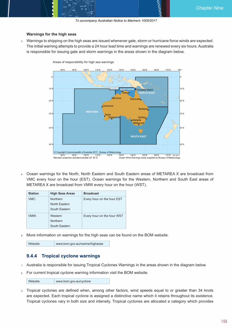
Warnings for the high seas3. Warnings to shipping on the high seas are issued whenever gale, storm or hurricane force winds are expected.
The initial warning attempts to provide a 24 hour lead time and warnings are renewed every six hours. Australia is responsible for issuing gale and storm warnings in the areas shown in the diagram below.
!
!
!
!
!
!
!
!
!
!
!
PerthSydney
Darwin
Broome
Brisbane
AdelaideMelbourne
Esperance
Carnarvon
Townsville
Thursday Island
WESTERN
SOUTH EAST
NORTH EASTNORTHERN
180°
180°
170°E
170°E
160°E
160°E
150°E
150°E
140°E
140°E
130°E
130°E
120°E
120°E
110°E
110°E
100°E
100°E
90°E
90°E
80°E
80°E
0° 0°
10°S 10°S
20°S 20°S
30°S 30°S
40°S 40°S
50°S 50°S
Mercator projection standard parallel 22º 30' S Ocean Wind Warnings areas supplied by Bureau of MeteorologyOct 2017
© Copyright Commonwealth of Australia 2017, Bureau of Meteorology
Areas of responsibility for high sea warnings
4. Ocean warnings for the North, North Eastern and South Eastern areas of METAREA X are broadcast from VMC every hour on the hour (EST). Ocean warnings for the Western, Northern and South East areas of METAREA X are broadcast from VMW every hour on the hour (WST).
Station High Seas Areas Broadcast
VMC: NorthernNorth Eastern South Eastern
Every hour on the hour EST
VMW: Western Northern South Eastern
Every hour on the hour WST
5. More information on warnings for the high seas can be found on the BOM website.
Website: www.bom.gov.au/marine/highseas
9.4.4 Tropical cyclone warnings
1. Australia is responsible for issuing Tropical Cyclones Warnings in the areas shown in the diagram below.
2. For current tropical cyclone warning information visit the BOM website.
Website: www.bom.gov.au/cyclone
3. Tropical cyclones are defined when, among other factors, wind speeds equal to or greater than 34 knots are expected. Each tropical cyclone is assigned a distinctive name which it retains throughout its existence. Tropical cyclones vary in both size and intensity. Tropical cyclones are allocated a category which provides
To accompany Australian Notice to Mariners 1005/2017

209
Chapter Eleven
• have information available regarding timber components, such as history of refits etc.
• contain/confine pets or animals on board
Website: www.agriculture.gov.au/biosecurity/avm/vessels/non-commercial-vessels
11.9.5 Cruise vessels
1. The Department of Agriculture and Water Resources considers cruise vessels to be a high biosecurity risk. Under the Biosecurity Act 2015 (Cth), cruise vessels must submit the following documents to the department prior to entering Australian ports or waters:
• Pre-Arrival Reporting (PAR’s) should be submitted within 96 -12 hours of the estimated time of arrival (ETA) of the vessel at the first Australian port of call.
• Ballast water reports are to be submitted with the PAR, no later than 12 hours before a vessel enters Australia.
• A human health form must be submitted 12 hours prior to arrival at every subsequent port outlining any new illnesses and/or deaths on board since their last assessment/inspection.
• A Live Plants Conveyances Log must be submitted prior the voyage, detailing all live plants on board the vessel, location and the condition and maintenance history.
2. To assist industry to plan cruise itineraries for the next cruise season in advance (up to two years), all proposed itineraries must also be submitted to the Maritime Travellers Processing Committee (MTPC) for approval by the Commonwealth Government agencies concerned.
3. The MTPC can be contacted at:
Website: www.border.gov.au/Trav/Ente/Avia/Maritime/cruise-ships
11.9.6 Vessel clearance fees and charges
1. Services provided by the Department of Agriculture and Water Resources to manage incoming international vessels; and returning Australian vessels, are administered through cost-recovered arrangements, as per the Biosecurity Cost Recovery Implementation Statement 2015. For information on relevant fees for vessel clearances see:
Website: www.agriculture.gov.au/fees/charging-guidelines
11.9.7 Biosecurity reporting obligations
1. Delivery of biosecurity inspection services is a crucial part of the Department of Agriculture and Water Resources business that regulates approximately 17,000 commercial vessels and 1,000 non-commercial vessels (such as itinerant yachts) per year.
2. Pre-arrival information, and changes, for maritime conveyances (vessels) must be reported in a form approved by the Director of Biosecurity, which is the Maritime Arrivals Reporting System (MARS). Electronic offline forms can be used where there is limited connectivity, but they do not constitute the approved form. Your reporting obligations are met once your information has been submitted in MARS.
3. MARS is an online web portal to be used by commercial vessel masters and shipping agents to submit pre-arrival documents required of all international vessels seeking Australian biosecurity clearance. MARS has functionality to view information related to the status of your vessel.
To accompany Australian Notice to Mariners 1005/2017
210
Seafarers Handbook for Australian Waters
• Vessel Operator Responsibilities: The operator of the vessel is obligated to accurately report information in accordance with Section 193 of the Biosecurity Act 2015. This information must be lodged in MARS no later than 12 hours prior to arrival.
• Shipping Agent Responsibilities: Where the vessel operator uses a shipping agent, the agent is responsible for lodgement of accurate and timely information into MARS. The agent must ensure that this information is a true and correct representation of the reports provided by the vessel operator, and that any changes have been confirmed with the operator.
• Any changes in circumstances during the voyage in Australian waters must be reported to the department as soon as practicable.
4. There is now a single source of information for biosecurity directions and advice for each voyage. This is the Biosecurity Status Document (BSD). The BSD is auto generated in MARS and is version controlled to reflect any reported changes to directions or status occurring during a voyage. It uses a traffic light system as a visual cue to alert the user regarding the vessel status and any associated directions or advice issued by the department.
5. The BSD document will be emailed to the port agent (and master where there is an email address) any time conditions change and will include:
• approval to berth
• certificate of pratique
• ballast water and non-first point of entry approvals
• treatment directions
Accessing MARS6. MARS a secure portal environment and accessible only through registration which will provide and a user
name and the password. Access to information will be based on security permissions. Access to the portal will be via the Department of Agriculture and Water Resources website.
What commercial vessel types need to use MARS• Cruise
• General cargo
• Barges
• Break bulk
• Heavy lift
• Tugs
• Tankers
A key policy initiative, the Vessel Compliance Scheme7. One of the key policy initiatives being developed in conjunction with MARS is the Vessel Compliance Scheme
(VCS). This compliance scheme provides a transparent and flexible regime for improved compliance by vessel operators. The core objective of the VCS is to provide greater visibility to clients on what department officers look for when they board a vessel and the consequences of failing to comply with these requirements.
8. An efficient and effective compliance scheme is essential to ensuring resources are targeted at vessels that present the greatest risk to the favourable pest and disease status of Australia. The key aim of this scheme is providing a framework of ‘informed compliance’ where vessels understand the department’s requirements and seek to comply in order to receive reduced intervention and costs. This encourages vessel masters and agents to comply with the department’s requirements, reducing inadvertent and opportunistic non- compliance and
• Tankers
• Livestock carriers
• Containers
• Ro-Ros
• Government and Military
• Fishing
To accompany Australian Notice to Mariners 1005/2017

211
Chapter Eleven
create an effective penalty mechanism for deliberate non-compliance. Vessels that continue to demonstrate high levels of non-compliance will be still be able to visit Australia, but will be subject to increased fees and intervention.
9. The Department of Agriculture and Water Resources has produced a number of publications to help vessel masters and agents prepare for biosecurity inspection.
Website: www.agriculture.gov.au/biosecurity/avm/vessels/mars/vessel-compliance
11.9.8 Ballast water management
1. Each year about 150 million tonnes of ballast water is discharged in Australian waters from overseas vessels. Australian scientists have identified over 200 introduced marine species in Australian coastal waters, most of which have been translocated from overseas ports to Australian ports via shipping. A number of these organisms have become harmful to Australia’s marine environment, threatening fisheries, aquaculture, tourism industries and public health.
2. Unlike other major pollutants of the oceans that can eventually be cleaned up, harmful aquatic organisms and pathogens, once established, are virtually impossible to eradicate and can have serious and permanent consequences.
3. The impact from harmful aquatic organisms threatens marine and estuarine environments in Australia and around the world.
4. The shipping industry operates within a highly regulated environment established by the IMO. The International Convention for the Control and Management of Ships Ballast Water and Sediments (BWM Convention) was adopted by a Diplomatic Conference at IMO in February 2004. The BWM Convention aims to prevent the potentially devastating effects of the transfer of harmful aquatic organisms through ballast water discharge.
5. The BWM Convention will enter into force 12 months after 30 IMO Member States; representing 35 percent of world merchant shipping tonnage have ratified the Convention. Australia has signed the Convention subject to ratification and as a signatory is obliged to refrain from actions that would defeat the object and purpose of the Convention.
6. Under the BWM Convention, ballast water exchange in the open sea will be progressively replaced by ballast water treatment using onboard ballast water management systems (BWMS). The feasibility of this replacement is related to the effectiveness of the treatment of ballast water and the probability aquatic organisms have of surviving after the treated ballast water is discharged into the sea. In addition, the exchange of ballast is not always feasible in areas that do not meet the requirements of depth and distance from land.
7. It is important that officers and crew are familiar with the procedures for managing ballast, whether that be by exchange or treatment. Regular training must be undertaken with the aim to minimise possible safety hazards, for example during the exchange of ballast water as this operation can directly influence the safety of the vessel.
Website: www.agriculture.gov.au/biosecurity/avm/vessels/ballast
11.9.9 Mandatory ballast water management requirements
1. The Conveyances and Ports Section of the Department of Agriculture and Water Resources - the Australian Government’s lead agency for the regulation of ballast water taken up outside Australia’s Territorial Sea (TS).
2. On 1 July 2001, after extensive consultation with the IMO and the shipping industry, Australia implemented mandatory ballast water management requirements requiring vessels to achieve a 95 percent volumetric exchange of ballast water.
To accompany Australian Notice to Mariners 1005/2017

212
Seafarers Handbook for Australian Waters
3. All internationally plying vessels intending to discharge ballast water anywhere inside the Australian TS are required to manage their ballast water in accordance with Australia’s Ballast Water Management Requirements.
4. The Australian Ballast Water Management Requirements provide guidance on how vessel operators should manage ballast water when operating within Australian seas in order to comply with the Biosecurity Act 2015. They also align to the International Convention for the Control and Management of Ships’ Ballast Water and Sediments 2004 (the Ballast Water Management Convention), which entered into force internationally on 8 September 2017.
5. Full details of the Australian ballast water management requirements may be downloaded from the Department of Agriculture and Water Resources website.
Website: www.agriculture.gov.au/biosecurity/avm/vessels/ballast/australian-ballast-water-management-requirements
6. Australia does not require any action by the Master that imperils the lives of seafarers or the safety of the ship.
7. All commercial vessels arriving in Australia from international waters are required to submit a Pre-Arrival Report (PAR) to the Department of Agriculture and Water Resources 12-96 hours prior to arrival at an Australian port. The PAR may be submitted electronically, which is the department’s preferred method of submission (ePAR), or by email or fax (PAR) to the Maritime National Coordination Centre (MNCC).
8. Masters / agents who do not submit the PAR to the Department of Agriculture and Water Resources will not be given formal biosecurity clearance to enter port. This will cause delays to the vessel and additional charges will be incurred by the vessel.
9. The PAR requires Masters to declare whether or not they intend to discharge ballast in Australian waters and whether accurate records of ballast exchanges have been maintained.
10. Vessel Masters may also submit an Australian Ballast Water Management Summary Sheet (ABWMS) to the Department of Agriculture and Water Resources MNCC. The ABWMS requires replaces the previous versions of this form which were known as the “AQIS Ballast Log and the AQIS Ballast Water Summary” and requires details about ballast water uptake ports, mid ocean exchanges and intended Australian discharge locations.
11. Vessels are not permitted to discharge ballast water in Australian waters until the Department of Agriculture and Water Resources has verified and confirmed that appropriate ballast exchanges have been conducted. Ballast verification can occur prior to arrival by submitting the ABWMS to the MNCC for assessment prior to arrival or alternatively an onboard verification can be conducted by biosecurity officers following arrival.
12. Completed originals of both the PAR and ABWMS, including any comments by biosecurity officers on the back of the forms, must be retained on the vessel for a period of two years and provided to the Department of Agriculture and Water Resources on request.
13. Vessels cannot discharge ballast water without written permission from the Department of Agriculture and Water Resources.
14. Vessels that are eligible for PDC (Pratique Documentary Clearance) may be required to undergo an onboard ballast water verification at no further charge, provided ballast water exchanges and documentation are deemed as compliant by a biosecurity officer. This activity may be conducted at a first or subsequent port of arrival. Notification of inspection times will be given through the ship’s agent.
To accompany Australian Notice to Mariners 1005/2017
213
Chapter Eleven
11.9.10 Ballast water management using type-approved ballast water management systems
1. Once the BWM Convention enters into force, Australia will recognise the IMO’s approval process and accept discharge from BWMS that have received Type Approval. Prior to the Convention entering into force, vessels arriving in Australian waters are required to continue to manage their ballast water in accordance with Australia’s current ballast water requirements but can apply to use Type Approved BWMS on future voyages. Applications will only be considered on a case by case basis.
2. Ship agents and vessel operators are requested to notify the Department of Agriculture and Water Resources of any arriving vessels fitted with a BWMS with intended use to satisfy Australia’s current ballast water management requirements. Specific information (including vessel details, type of BWMS, BWMS certification, discharge intentions and voyage details) will need to be provided to the Department of Agriculture and Water Resources as soon as possible, but at least 10 working days prior to arrival and cooperation will be sought from the vessel upon arrival in the form of providing access for biosecurity officers to assist in the verification. The intention of the verification inspection is to determine whether the crew is familiar with the operation of the system and that it has been operated in accordance with systems stated operating parameters and the ships’ ballast water management plan. If the vessel meets the Department of Agriculture and Water Resources verification requirements it will be granted approval to use the BWMS on future visits to Australia.
3. For further information on Australia’s Ballast Water Management Requirements and ballast water reporting requirements can be obtained by contacting the National Seaports Program in the Department of Agriculture and Water Resources.
National Seaports Program: Maritime National Coordination Centre:
Email: [email protected] [email protected]
Telephone: +61 409 604 543 (mobile) / 1800 020 504 (Aust only) 1300 004 605 (Aust only)
Fax: 1300 005 882
Website: www.agriculture.gov.au/biosecurity/avm/vessels
To accompany Australian Notice to Mariners 1005/2017

221
Chapter Eleven
• dispose of all animal waste in a manner approved by the Department of Agriculture and Water Resources
• provide immediate notification if any animal on board becomes ill, dies or escapes
11.9.23 Torres Strait biosecurity travel regulations
1. Commonwealth Biosecurity regulations apply in the Torres Strait that prevent certain goods such as fresh produce, live plants and animals from travelling southward within the region and from the region to mainland Australia.
2. All vessels over seven metres which have been in the Torres Strait and are returning to mainland Australia must report to the Department of Agriculture and Water Resources 12 to 96 hours before making landfall on the mainland. After biosecurity assessment, masters will be issued with a notification number. Masters are required to record this number in their vessel’s logbook for auditing purposes. Vessels transiting the Torres Strait in the main shipping channel and not travelling into and stopping in the Torres Strait are exempt from these requirements. The Department of Agriculture and Water Resources can be contacted on VHF CH 16 on Thursday Island or through harbour authorities at most mainland ports. Masters are strongly advised to contact the Department on Thursday Island or Cairns, prior to travelling into the Torres Strait for further biosecurity information.
3. For more information:
TelephoneThursday Island:Cairns:
+61 7 42120185+61 7 1800 900 090 (select option 1, then option 6)
Website: www.agriculture.gov.au/biosecurity/australia/naqs/torres-strait
Torres Strait Special Biosecurity Zones
11.10 Military Information
11.10.1 Military firing practice and exercise areas
1. Military practice areas are published in the Commonwealth Government Gazette and the Designated Airspace Handbook (published on Air Services Australia website). Restricted and dangerous areas with associated airspace coordinates and chartlets are published on the Australian Hydrographic Service (AHS) website.
Notification of warnings2. As clear range procedures are followed no broadcast warnings will be issued in respect of weapons firing
practices in the areas depicted in Notice to Mariners No 9 and in this section major exercises will be the
To accompany Australian Notice to Mariners 1005/2017

To accompany Australian Notice to Mariners 1009/2017
To accompany Australian Notice to Mariners 1014/2017

To accompany Australian Notice to Mariners 1014/2017

To accompany Australian Notice to Mariners 1018/2017

To accompany Australian Notice to Mariners 1018/2017

To accompany Australian Notice to Mariners 1019/2017