AUSAIA GEOOGICA SUEY OGAISAIO - Geoscience … e Ausaia Geoogica Suey Ogaisaio (AGSO as a o is suy...
46
AUSTRALIAN GEOLOGICAL SURVEY ORGANISATION Marine Geoscience and Petroleum Geology Program AGSO RECORD 1993/48 DEEP STRUCTURE OF THE SOUTHERN NORTH WEST SHELF: OFFSHORE CANNING BASIN (SNOWS-3) PRE-CRUISE REPORT. H.M.J. Stagg & J. Leven • •• I 11 1 11 - * R 9 3 0 4 8 1 0 1 * Australian Geological Survey Organisation
Transcript of AUSAIA GEOOGICA SUEY OGAISAIO - Geoscience … e Ausaia Geoogica Suey Ogaisaio (AGSO as a o is suy...

AUSTRALIAN GEOLOGICAL SURVEY ORGANISATION
Marine Geoscience and Petroleum Geology Program
AGSO RECORD 1993/48
DEEP STRUCTURE OF THE SOUTHERN NORTH WEST SHELF:OFFSHORE CANNING BASIN (SNOWS-3) PRE-CRUISE REPORT.
H.M.J. Stagg & J. Leven
••• I 11 1 11- * R 9 3 0 4 8
1
0 1 * Australian Geological Survey Organisation

•••
DEPARTMENT OF PRIMARY INDUSTRIES AND ENERGY^•
•Minister for Resources: Hon. Michael LeeSecretary: Greg Taylor^ •
••
AUSTRALIAN GEOLOGICAL SURVEY ORGANISATION^•
•Executive Director: Roye Rutland^ •
•C Commonwealth of Australia^ •
•ISSN: 1039-0073 •ISBN: 0 642 19367 3
This work is copyright. Apart from any fair dealings for the purposes of study,research, criticism or review, as permitted under the Copyright Act, no part may bereproduced by any process without written permission. Copyright is the responsibilityof the Executive Director, Australian Geological Survey Organisation. Inquiriesshould be directed to the Principal Information Officer, Australian GeologicalSurvey Organisation, GPO Box 378, Canberra City, ACT, 2601.
•••
••••
••••••
Australian Geological Survey Organisation^ •

CONTENTS
EXECUTIVE SUMMARY^ 1
INTRODUCTION^ 4
EXPLORATION HISTORY^ 5
PHYSIOGRAPHY^ 7
GEOLOGY OF THE OFFSHORE CANNING BASIN^ 8
HYDROCARBON POTENTIAL^ 13
GENERAL OBJECTIVES AND SPECIFIC PROBLEMS^ 16
PROPOSED PROGRAM FOR SNOWS-3^ 18
REFERENCES^ 20
APPENDICES
1. Executive Summary from SNOWS-1 post-cruise report^ 23
2. Executive Summary from SNOWS-2 post-cruise report^ 25
3. Wells to be tied on SNOWS-3^ 27
4. Way points for SNOWS-3^ 30
5. Seismic acquisition parameters^ 32
6. Equipment to be utilised on SNOWS-3^ 33
7. Companies consulted^ 34
Australian Geological Survey Organisation
•
FIGURES
•••
1. Regional geological setting of the North West Shelf (Stagg, 1993)^ 35 ••
2. Regional and deep-seismic lines in the offshore Canning Basin^ 36 •3. Offshore Canning Basin, bathymetry and wells^ 37 •4. Dredge sites on northern Exmouth Plateau, Rowley Terrace, Scott Plateau •
(Exon & others, 1991)^ 38 •5. Offshore Canning Basin, structural elements^ 39 •6. Offshore Canning Basin, stratigraphic table (Poll, 1983; Lipski & Beattie,
1992)^ 40 ••
7. SNOWS-3 proposed seismic lines, overlain on bathymetry^ 41 •8. SNOWS-3 proposed seismic lines, overlain on tectonic elements^ 42 •
••••••••••••••••••
Australian Geological Survey Organisation^ •

••• EXECUTIVE SUMMARY•• In mid-1991, the Bureau of Mineral Resources (BMR; now the Australian Geological Survey
Organisation, AGSO) commenced a program of deep-seismic acquisition on the southern• North West Shelf with the intention of providing a regional framework data set for explorers
in this highly prospective segment of Australia's continental margin. In particular, the• program aims to:
• • Determine the broad regional structural framework of the southern North West Shelf by• examining the boundaries between the major structural elements;
• • Determine the deep crustal structure of the region;
• • Assess the control of deep structure on the development of the major hydrocarbon fields
• and plays, and in particular the structural and depositional effects resulting fromreactivation of these structures; and
•• Acquire a set of high-quality seismic tie lines linking the deeper exploration wells
• throughout the region, to allow regional seismic correlations.
To address these aims, a multi-cruise program was devised during which deep-seismic data• are being recorded. The first survey, SNOWS-1 (for Southern North West Shelf; AGSO
Survey 101; Stagg, Brassil, & others,1991) was concentrated in the Barrow and Dampier• Sub-basins and inner Exmouth Plateau. 1654 km of good-quality seismic data tied to 20
•exploration wells were recorded and processed; these data frequently show basin structuredown to a depth of at least 10 s two-way time (TWT). The second survey, SNOWS-2
• (AGSO Survey 110; Stagg & Survey 110 Shipboard Party, 1992), acquired more than 2800km of high-quality deep seismic data along 13 lines in the Beagle, Dampier, and Barrow Sub-
• basins, and over the full width of the Exmouth Plateau in mid-1992. These lines were tied to21 exploration wells, of which 3 were also tied during SNOWS-I, and again show reflections
• down to 12 s TWT.• In the second half of 1993, the Marine Geosciences and Petroleum Geology Program• (MGPG) at AGSO will continue this program with the third survey in the area, to be known
as SNOWS-3. The survey will be concentrated in the offshore Canning Basin, and will tie in• with the SNOWS-2 survey to the southwest in the Beagle Sub-basin, and the 1993 Browse
• Basin survey to the northeast. The survey will tie the principal exploration wells in the regionand is expected to acquire at least 3000 km of data along long regional lines; the program
• allows for up to 3500 km of data to be recorded. As part of the MGPG program of acquiringdeep crustal transects across the margin adjacent to the North West Shelf, the opportunity
• will be taken to record at least one margin transect from near the coast out to Ocean DrillingProgram Site 765 on the southeast Argo Abyssal Plain.
• Recording parameters for the survey will include a 4800 m streamer, configured with 192 x25 m active groups; the record length will be 16 seconds, and the sample interval 2 msec.
• The seismic source will be provided by tuned airgun arrays of total capacity 49 litres, firedevery 50 metres to give 48-fold CDP coverage. These parameters are the same as were used
• on the SNOWS-1 and SNOWS-2 surveys.
•• Australian Geological Survey Organisation

Navigation for the survey will be provided by differential Global Positioning System (DGPS),using shore reference stations in Western Australia. Full differential coverage should beachieved for the entire survey and it is estimated that positional accuracy should be betterthan +/- 10 metres.
Proposed deep seismic profiles
The proposed lines for SNOWS-3 total 3491 km and tie 6 exploration wells, of which onewas also tied on SNOWS-2, and ODP Site 765 on the Argo Abyssal Plain. A brief outline ofthe location and function of each line is as follows (110/ prefix lines are from SNOWS-2; BB/prefix lines are the programmed lines for the Browse Basin deep-seismic survey):
SNOWS3-A: (555 km; ties to Lacepede-1A, lines SNOWS3-G, H, K, L, BB-F, G, H):Palaeozoic dip line, Leveque Platform - Fitzroy Trough - Broome Platform - SamphireDepression - Wallal Depression. Due to shallow water in the southwest, it will probably notbe possible to continue this line on to the Lambert Shelf.
SNOWS3-B: (347 km; ties to lines SNOWS3-C, I, K„ BB-G, I): Palaeozoic dip line,Leveque Platform - Fitzroy Trough - Broome Platform.
SNOWS3-C: (150 km; ties to lines SNOWS3-B, G, H): Palaeozoic dip line, margin ofBroome Platform - Samphire Depression - Wallal Depression - Lambert Shelf margin.
SNOWS3-D: (465 km; ties to lines SNOWS3-G, H, J, K, L, BB-J, 110/4, 5, 7, 8):Mesozoic strike and tie line from southwest extension of Browse Basin - Rowley Sub-basin -northern flank of Bedout High - northern Beagle Sub-basin. This line is the remaining link inthe major strike line that extends for the length of the North West Shelf.
SNOWS3-E: (138 km; ties to ODP Site 765, lines SNOWS3-H, K): Short strike line onoceanic crust in southeast Argo Abyssal Plain between magnetic anomalies M25 and M26.Although of low priority from the exploration viewpoint, this line will provide deep crustaldata across a major oceanic fracture zone.
SNOWS3-F: (159 km; ties to Keraudren-1, Lagrange-1, lines SNOWS3-G, H): Mesozoic?dip line, Lambert Shelf - Bedout Sub-basin - Bedout High.
SNOWS3 -G: (343 km; ties to Minilya-1, Lagrange-1, lines SNOWS3-A, C, D, F, H, K,110/4, 5, 6, 8): Beagle Sub-basin - Bedout High - Broome Platform. This line is designed toprovide an orthogonal crossing of the major N-S trending structures that comprise the?transform dislocation between the northern Carnarvon Basin (Beagle Sub-basin) and RowleySub-basin.
SNOWS3-H: (480 km; ties to Lagrange-1, ODP Site 765, lines SNOWS3-A, C, D, E, F,G): Prime offshore Canning Basin transect, Samphire/Wallal Depressions - Bedout Sub-basin- Bedout High - Rowley Sub-basin - Argo Abyssal Plain.
SNOWS3-I, J: (combined length 222 km; ties to lines SNOWS3-B, D): Mesozoic dip line,outer Broome Platform - Rowley Sub-basin.
2
Australian Geological Survey Organisation
SNOWS3-K: (388 km; ties to East Mermaid-1, lines SNOWS3-A, B, D, E, G): Mesozoicdip line, Broome Platform - Rowley Sub-basin - Argo Abyssal Plain.
•^SNOWS3-L: (244 km; ties to Wamac-1, lines SNOWS3-A, B, D): Palaeozoic strike andMesozoic dip line, Fitzroy Trough - Rowley Sub-basin.
3
Australian Geological Survey Organisation

INTRODUCTION
The North West Shelf is a general term that refers to the suite of geologic provinces• comprising the continental margin of northwest Australia, approximately from Northwest
Cape to Darwin, a distance of some 2000 km and encompassing an area (including marginal• plateaux) of approximately 800 000 krn 2 (Fig. 1). The principal sedimentary basins are, from
• south to north, the northern Carnarvon, offshore Canning, Browse, and Bonaparte Basins.While the majority of the sedimentary fill in most of these basins is of Mesozoic age, all of the
• basins probably began forming in the Palaeozoic.
• As production of hydrocarbons from Bass Strait dwindles, the North West Shelf is certain tobecome the major source of hydrocarbons in Australia. To date, the principal discoveries are
• oil and gas in the Barrow Sub-basin, gas/condensate and more recently oil in the Dampier• Sub-basin, gas/condensate in the Browse Basin, and oil and gas in the Bonaparte Basin.
1989 estimates suggest that the region contains undiscovered resources of 40-500 million• kilolitres (280-3200 million barrels) of crude oil, 240-1300 billion cubic metres (8- 45 tcf) of
saleable gas, and 55-440 million kilolitres (350-2800 million barrels) of condensate, primarily• in the Carnarvon, Browse, and Bonaparte Basins (BMR, 1989).
• While portions of the North West Shelf have been quite intensively explored since the 1960's• (particularly the Barrow-Dampier Sub-basins and parts of the Bonaparte Basin), there has
been very little recent revision of its regional structural framework using modern extensional• tectonic concepts, and large parts of the region, particularly the offshore Canning Basin,
•remain relatively under-explored. The Marine Geoscience and Petroleum Geology Programat the Australian Geological Survey Organisation (AGSO), as part of its study program on
• the North West Shelf, is acquiring regional deep seismic data across and between the majorsedimentary basins, with the aim of improving our understanding of the linkages between the
• major structural elements and allowing revision of the gross structure of the region. Thisinformation is considered to be critical in developing new exploration strategies, and will aid
• future basin framework and resource studies in the region.
• To address the structural framework problems of the North West Shelf, a series of deep-• seismic surveys using the AGSO research vessel Rig Seismic have been planned during a 4-
year period. The program is as follows:
• 1. Vulcan Sub-basin and adjacent areas - 1900 km of deep seismic data - completedNovember-December, 1990 (O'Brien & Williamson, 1990).
2. Bonaparte Basin (Petrel Sub-basin) - 2090 km of deep seismic data - completed April-• May, 1991 (Wilcox & Ramsay, 1991).
• 3. Northern Carnarvon Basin (Exmouth-Barrow-Dampier-Beagle Sub-basins and Exmouth• Plateau; SNOWS-1) - 1654 km of deep seismic data - completed May-June, 1991 (Stagg,
Brassil, & others, 1991; Appendix 1).••••
4
Australian Geological Survey Organisation

•••
4. Northern Carnarvon Basin (Beagle-Dampier-Barrow Sub-basins; Exmouth Plateau;SNOWS-2) -2868 km of deep seismic data completed in June-July, 1992 (Stagg &Survey 110 Shipboard Party, 1992; Appendix 2).
5. Timor Sea - 3611 km of deep-seismic data acquired in January-March 1993 (Pigram,1992b). 730 km of this survey were shot in the Timor Sea Australia-Indonesia Zone ofCooperation Area A for Nopec Australia.
6. Bonaparte Basin (Malita Graben and Petrel Sub-basin) - 3602 km of deep-seismic data,acquired during May, 1993 (Pigram, 1992a).
7. Browse Basin - approximately 3000 km of deep-seismic data to be acquired during June,1993 (Symonds, 1993).
8. Offshore Canning Basin (SNOWS-3) - 3000+ km of deep-seismic data scheduled forrecording in either July-August or September-October, 1993 (subject of this report).^•
9. Timor Sea in-fill program - 3000+ km of deep-seismic data, scheduled for recordingduring the period January-August, 1994.
10. Northern Scott Plateau - Roti Basin-Browse Basin - 3000+ km of deep-seismic datascheduled for recording in November-December, 1993.
11. Offshore Canning Basin in-fill and eastern Exmouth Plateau (SNOWS-4) - 3000+ km ofdeep-seismic data, scheduled for recording during the period January-August, 1994.
12. Gascoyne and Exmouth Sub-basins (SNOWS-5) - 3000+ km of deep-seismic data,scheduled for recording during the period January-August, 1994.^ •
By the end of the survey program outlined here, there will be available a network ofapproximately 30000 km of deep-seismic data (recorded at up to 16 seconds TWT) for all ofthe major basins of the North West Shelf, from Northwest Cape to the Timor Sea.
PREVIOUS EXPLORATION
The most intense exploration on the North West Shelf has been in the northern CarnarvonBasin and in the Timor Sea, where a number of significant oil and gas fields have beendiscovered. The discovery of giant gas fields in the Dampier Sub-basin of the northernCarnarvon Basin by the Woodside-Burmah Group in 1971 greatly spurred the explorationeffort.
In the offshore Canning Basin there have been three phases of petroleum exploration, withactivity peaks in the early 1970s and early 1980s; the third round of activity commenced in1987.
••
5
Australian Geological Survey Organisation^ •
•••••••••
•••••
•••
••
••••
SEISMIC
Compared to the northern Carnarvon Basin and Timor Sea, the offshore Canning Basin hasonly been sparsely explored with somewhat more than 40 000 km of multichannel seismic(MCS) data being recorded since the late 1960s. Few of these surveys extend into deepwater. The early seismic surveys were conducted by BOCAL from the 1960's to the early1970's, and subsequently by AMAX, BP, Esso, and Hematite. The early exploration phasemainly comprised regional seismic acquisition with a few detailed surveys. The early 1980sexploration phase included some high-quality seismic surveys in the nearshore areas,especially on the flanks of the Fitzroy Trough, but only limited exploration further offshore.Two regional seismic surveys by the Japan National Oil Corporation in 1987 and 1988 haveprovided a valuable regional seismic grid of some 10500 km in the offshore Canning Basin(Japan National Oil Corporation LJNOC], 1988, 1989; Fig. 2).
EXPLORATION WELLS (Fig. 3)
Six wells were drilled between 1970 and 1973 during the first exploration phase and a furtherseven wells were drilled between 1980 and 1984 in the second phase. The drilling targetswere Mesozoic and Late Palaeozoic clastic reservoirs within the largest known potentialtraps. Of the seven wells drilled in the second exploration phase, four tested potentialcarbonate plays and three tested clastic intervals. The only wells in the offshore CanningBasin to provide any encouragement to exploration were Perindi-1 in the nearshore part ofthe Fitzroy Trough (minor oil show in a Permian reservoir) and Phoenix-1 on the BedoutHigh (minor gas show in a Triassic reservoir). Phoenix-2, sited to further delineate thePhoenix-1 shows, was unsuccessful.
DREDGING (Fig. 4)
The continental margin adjacent to the offshore Canning Basin is steep and, north of theExmouth Plateau, deeply incised by canyons. The sedimentary section was sharply cleaved atthe time of margin breakup, and this, in combination with the physiography, makes themargin an attractive target for seabed dredging. Since the late 1970s, four research cruiseshave successfully sampled this margin, as follows:
1979 Bundesanstalt fur Geowissenschaften und Rohstoffe (BGR) Sonne Research Cruise SO-8 (von Stackelberg & others, 1980; Exon & others, 1982): northern margin of ExmouthPlateau.
1986 BMR Survey 56 (Exon & Williamson, 1988; von Rad & others, 1990): northern marginof Exmouth Plateau.
1990 BMR Survey 95 (Exon & Ramsay, 1990): northern margin of Exmouth Plateau.
1990 BMR Survey 96 (Colwell, Graham, & others, 1990): margins of the Rowley Terraceand Scott Plateau.
In addition to the reports referred to above, a major geological synthesis of the margin iscurrently underway at AGSO, with the results due to be published in a forthcoming issue ofthe AGSO Journal of Australian Geology & Geophysics.
6
Australian Geological Survey Organisation
••••
•••
OCEAN DRILLING PROGRAM (Fig. 3)
During 1988, Legs 122 and 123 of the Ocean Drilling Program (ODP; von Rad, Haq &others, 1992; Gradstein, Ludden & others, 1992) both drilled sites on the northwestAustralian continental margin that are relevant to the SNOWS-3 program.
ODP Sites 759-761 and 764, drilled on the Wombat Plateau (on the northern margin of theExmouth Plateau) were designed to evaluate the syn-rift and post-rift structural andpalaeoenvironmental evolution of eastern Gondwanaland (von Rad & others, 1992). Ofpartciular relevance to exploration on the North West Shelf was the coring of an UpperTriassic (Rhaetian) reef complex in Site 764 (Williamson & others, 1989), a discovery whichpotentially opens up an entirely new range of plays for rocks of this age on the North WestShelf.
ODP Site 765, on the southeast corner of the Argo Abyssal Plain, was drilled with multipleobjectives (Appendix 3); the most relevant of the objectives to the SNOWS-3 program wasdetermination of the age of onset of sea-floor spreading. Initial biostratigraphy fromsediments overlying basement gave an Early Cretaceous age, 20 Ma younger than expected(Gradstein, Ludden, & others, 1990). However, subsequent re-analysis and modelling of themagnetic lineations, radiometric age dating of the basement basalts, and furtherbiostratigraphic studies have resulted in the onset of sea-floor spreading now being •
interpreted at shortly prior to anomaly M26 time (163 Ma), approximately at the Callovian-Oxfordian boundary (Fullerton & others, 1989; Sager & others, 1992). Site 765 will be tiedby deep-seismic lines during SNOWS-3.
PHYSIOGRAPHY
CONTINENTAL SHELF
The continental shelf of the southern half of the North West Shelf has an arcuate outlinebounded by the coastline and the slope break at about 200m depth (Fig. 3). The shelf isapproximately 200 km wide in the southwest and narrows to approximately 150 km north ofBroome. Between Dampier and Broome, the continental shelf is relatively featureless,forming a gently sloping plain with slopes generally less than 0.25°. The De Grey River,which discharges near Port Hedland, has had relatively little effect on the bathymetry of thecontinental shelf. Northwest of Broome, the shelf shallows onto the Leveque Platform. Inthis region, the bathymetry is more complex, reflecting the structural control of the basementfaults associated with the Leveque Platform. On the western edge of the platform, slopesexceeding 0.25° are interpreted as the seafloor expression of the Beagle Bay Fault.
CONTINENTAL SLOPE
The width of the continental slope varies between 150 and 200 km. Stagg and Exon (1981)divided this region into an upper slope between the 200 and the 3000 m isobaths, termed theRowley Terrace, and a lower slope between the 3000 and the 5000 m isobaths with gradientsof up to 200 . The Rowley Shoals is a prominent physiographic feature of the Rowley
7
Australian Geological Survey Organisation
•••••

••Terrace. These three coral cays (Mermaid, Clerke, and Imperieuse Reefs) have developed as
• present-day pinnacle reefs, with diameters of about 20 kilometres in water depths exceeding
• 300 m, on the upper continental slope.
• The Swan Canyon is another major physiographic feature of this part of the continental slope,separating the Rowley Terrace from the Emu Spur on the northeastern Exmouth Plateau.
• This north-trending canyon debouches onto the Argo Abyssal Plain and has an axial slope of
• up to 6° and side-wall slopes in excess of 20°.
• CONTINENTAL RISE AND ARGO ABYSSAL PLAIN
4111^Oceanward of the offshore Canning Basin, the continental rise is extremely narrow,particularly northwest of the Rowley Shoals and east of the Swan Canyon. In this region, theArgo Abyssal Plain comes closest to the coastline, separating the Scott Plateau to the
• northeast from the Exmouth Plateau to the southwest. The Argo Abyssal Plain is generallyflat, with a gentle southeasterly slope of about 0.02°. The deepest portion (5730 m) is
• adjacent to the continental rise in the southeast (Stagg & Exon, 1981).
•
• GEOLOGY OF THE OFFSHORE CANNING BASIN
• REGIONAL SETTING (Fig. 1)
• The gross structure of the North West Shelf comprises a series of NE-SW trending passive• margin rift basins of Late Palaeozoic and Mesozoic age (comprising the Westralian Super-
basin; Yeates & others, 1986) that overlie three major NW-SE intra-cratonic basins of mainly• Early Palaeozoic age (the Carnarvon, Canning, and Bonaparte Basins). The Canning Basin is
by far the largest of the Early Palaeozoic basins, and occupies a central position along• Australia's northwest margin. While most of the basin lies onshore, seismic data confirm its
• presence beneath the continental shelf, although the full offshore extent is unknown due tothe oceanwards-thickening Mesozoic section.
This report will continue to use the name 'offshore Canning Basin' in describing the region;• however, it should be acknowledged that we are in fact dealing with 'stacked' basins. The
boundary between the intra-cratonic and passive margin systems can probably best be takenin the Late Carboniferous at the time of the Alice Springs Orogeny.
•STRUCTURAL ELEMENTS (Fig. 5)
•The main structural elements of the offshore Canning Basin can be most simply separated
• into those belonging to the intra-cratonic and the passive margin systems.
Intra-cratononic:
• Fitzroy Trough: This major sedimentary sub-basin has in the past also been referred toas the Fitzroy Graben, a name which has caused some confusion with regard to its
• geological origins. Detailed analysis of modern and deep seismic data show that theFitzroy Trough is an asymmetrical WNW-trending rift that formed by periods of crustal
•
•8
Australian Geological Survey Organisation

extension in the latest Middle to Late Devonian, the Carboniferous, and the Permian(Drummond & others, 1991). The Fitzroy Trough is bounded on its northeastern flankby the Lennard Shelf and the Precambrian Kimberley Basin onshore, and by the shallowbasement of the Leveque Platform offshore, and to the southwest by the Jurgurra Terraceand the shallow Broome Platform. Along strike, the Fitzroy Trough is contiguous withthe Gregory Sub-basin to the southeast, while to the northwest its limits are uncertain.The total sediment fill is at least 10-12 km, most of which had accummulated by the endof the Permian.
• Broome Platform (also known as the Broome Swell or Broome Arch): This is a majorWNW-trending, largely unfaulted, intra-basin high that separates the major FitzroyTrough to the northeast from the minor Walls] and Samphire Depressions and WillaraSub-basin to the southwest. Along strike to the southeast, the Broome Platform iscontiguous with the Crossland Platform, which separates the Gregory Sub-basin to thenortheast from the Kidson Basin to the southwest. As with the offshore limits of theFitzroy Trough, the northwestern boundary of the Broome Platform is over-printed bythe northeasterly fault trends of the Westralian Super-basin. Sediment cover over theBroome Platform is generally less than 2000 m.
• Willara Sub-basin; Samphire Depression; Wallal Depression: These three small sub-basins or depressions in the southwest Canning Basin contain relatively minor thicknessesof Palaeozoic sediments. Offshore they are overlain by the Mesozoic Bedout Sub-basin,while to the southeast they merge with the major Kidson Sub-basin of the southernmostCanning Basin.
Passive Margin (Westralian Super-basin)
The principal passive margin elements of the offshore Canning Basin are the Bedout andRowley Sub-basins and the intervening Bedout High (which may be a continuation of theBroome Platform). To the southwest, the boundary with the Beagle Sub-basin is somewhatarbitrary, but is usually taken at a down-to-the-west system of faults, the North Turtle Hinge.In the northeast, the boundary of the Rowley Sub-basin with the Browse Basin is alsoarbitrary, being taken at the narrowing of the rift system between the Leveque Platform to thesoutheast and the shallow basement of the southern Scott Plateau to the northwest.
The tectonics and structure of the Bedout and Rowley Sub-basins are quite different(Horstman & Purcell, 1988). The Bedout Sub-basin was a depocentre that was active in thePermian and Triassic, as well as during the Mesozoic and Tertiary, and the structures withinit were principally caused by Triassic tectonism. This sub-basin is largely 'enclosed', by theBroome Platform to the northeast, by thinning onshore to the southeast and southwest, andby the Bedout High to the north.
In contrast to the Bedout Sub-basin, while the Rowley Sub-basin may also have beenaccumulating significant amounts of sediment in the Permo-Triassic, it is primarily a Jurassic-Cretaceous feature. The sub-basin is bounded by structurally high areas to the south (BedoutHigh), southeast (Broome Platform), and north (Scott Plateau), but is open to the northeast(Browse Basin), southwest (Beagle Sub-basin), and to the northwest where the sub-basinwas breached at the time of margin breakup in the Jurassic. While this lack of present-dayenclosure may appear to reduce the possibility of good-quality source rocks accummulating,
9
Australian Geological Survey Organisation
••
••S

it is possible that, prior to breakup, the basin was bounded to the northwest by a structuralhigh which was subsequently rifted away, in which case pre-breakup palaeoenvironments mayhave been restricted. Although modern high-quality seismic data are sparse in the RowleySub-basin, the data that are available indicate that structuring in the centre of the basin isrelatively subdued, while the basin margins are extensively faulted and folded, indicating thatthe region has been subjected to both extension and compression or strike-slip movement.
TECTONIC EPISODES
Horstman & Purcell (1988) described three tectonic episodes that can be recognised in thehistory of the offshore Canning Basin, as follows:
1. In the Late Carboniferous, as part of the Alice Springs orogeny, faulting established a• basin system in which thick Permo-Triassic sediments subsequently accumulated. While
this period of deposition is principally known from the Bedout Sub-basin, it is quite• possible that similar sediments were also deposited in the Rowley Sub-basin.
• 2. A second major tectonic episode, in the Late Permian to Early Triassic, involved• extensive uplift, faulting, and volcanism. This episode has been named the 'Bedout
Movement' (Forman & Wales, 1981), since it is most pronounced in the Bedout Sub-• basin and on the Bedout High. It has also been interpreted as the onset of the final rifling
phase that culminated in the breakup of Australia from an unknown northern landmass in• the Middle Jurassic. A similar faulting episode probably occurred along much of the
• North West Shelf; however, elsewhere it is probably largely obscured by the largethickness of sediment that accumulated in the Westralian Super-basin during the Triassic
• and Jurassic.
• 3. The final significant phase of tectonism that affected the offshore Canning Basin occurred
• in the Jurassic and was associated with final margin breakup. In the Early Jurassic, the'Fitzroy Movement' produced some faulting and an erosional surface at the top of the
• Triassic that provides a regional seismic marker. Otherwise, the Bedout Sub-basinappears to have been relatively stable throughout the Jurassic, and the so-called Callovian
• 'breakup unconformity', prominent elsewhere on the North West Shelf, is not apparent inseismic data over large areas of the basin (although it is evident in some wells, such as
• Lacepede-1 and East Mermaid-1). The Jurassic rifting that is evident both in the northern• Carnarvon Basin and in the Browse Basin, is also evident on the eastern margin of the
Rowley Sub-basin, where faulting of this age is interpreted to abruptly terminate the• underlying, orthogonal Early Palaeozoic trends.
•••••••• 10
• Australian Geological Survey Organisation

STRATIGRAPHY (Fig. 6)
For the purpose of discussion in this pre-cruise report, the geological sequences of theoffshore Canning Basin have been divided into ten units, based on well correlations andonshore geological data (Brown & others, 1984; Forman & Wales, 1981) and the JNOCstudies (JNOC, 1988, 1989).
The following unconformities are common (but not ubiquitous) in the wells in the offshoreCanning Basin:
• Devonian to CarboniferousC3 Lower to Upper Carboniferous• within the Lower PermianCI Permian to Triassic• Triassic to JurassicCI Middle to Upper Jurassic• Cretaceous to Tertiary.
In the offshore Fitzroy Trough, wells have penetrated the Devonian section, but elsewhereoffshore wells have seldom drilled pre-Triassic rocks.
Basement.
Although no Precambrian rocks have been sampled in wells in the offshore Canning Basin,Precambrian basement rocks have been drilled in several wells in adjacent areas. Thesebasement rocks fall into two categories: metamorphic and volcanic. Banded iron formationand basic igneous rocks were intersected in the south Bedout Sub-basin and north TurtleArch (Forman & Wales, 1981). Goldwyer-1 on the Broome Platform encountered volcanicbasement rocks, and Leveque-1 on the Leveque Platform bottomed in gabbroic basement.Metamorphic basement was encountered in the Tappers Inlet-1, Meda-1 and Napier-4 wellson the Lennard Shelf and in the Thangoo-1 and Parda-1 wells onshore on the BroomePlatform.
Ordovician
The Lower Ordovician section consists of clastics (Nambeet and Goldwyer Formations) andcarbonates (Willara and Nita Formations). This shallow marine sequence has beenintersected in several onshore wells, and is thought to have been distributed widely in theonshore Canning Basin where it has a maximum drilled thickness of at least 3000 m.However, regional southeastwards tilting of the basin in the Late Ordovician to Devonianresulted in erosion and extensive removal of the upper part of this sequence.
Silurian to Early Devonian
The Early Devonian section in the onshore Canning Basin is dominated by continentalsediments of the Carribuddy Formation (evaporites) and the Tandalgoo Red Beds; theseformations are mainly restricted to the Kidson Sub-basin, the Broome Platform, and thesouthern flank of the Fitzroy Trough. The overlying marginal marine sandstone and siltstoneof the Poulton Formation is restricted to the Fitzroy Graben and Lennard Shelf.
11
Australian Geological Survey Organisation
S

Late Devonian - Early Carboniferous
Late Devonian sediments are characterised by the platform reef complex of the PillaraLimestone and the Nullara carbonate cycles within the onshore Canning Basin (Playford,1984). Offshore, the Pillara Limestone has been intersected in three wells on the offshoreextension of the Lennard Shelf (Kambara-1, Perindi-1, and Minjin-1), and seismic datasuggest that this sequence is also developed within the offshore Fitzroy Trough.
Early Carboniferous rocks were intersected in three wells in the offshore Canning Basin(Pearl-1, Lacepede-1A, and Wamac-1). This sequence is the equivalent of the regressiveclastic Fairfield Group and Anderson Formation onshore. In Pearl-1, the Early Carboniferoussequence consists wholly of shale, whereas in the other wells, the sequence is a non-marinesandstone characterised by a high content of calcareous matrix.
Onshore this sequence correlates with the well-known reef complexes of the Lennard Shelf,where reef development was fault-controlled; the associated lithologies include evaporites,shale, siltstones, sandstones, and carbonates.
Late Carboniferous to Late Permian
The Grant Formation consists of a substantial thickness of Late Carboniferous to EarlyPermian glacial fine- to coarse-grained sandstones. These are thickest in the Fitzroy Troughwhere the maximum thickness exceeds 2 km. The Early to Middle Permian post-glacialPoole Sandstone and Noonkanbah Formation, and the Late Permian Liveringa Group, aredominantly composed of sandstones and siltstones with minor limestone, and have majordepocentres in the Fitzroy Trough (>2000 m) and in the ICidson Sub-basin. Sediments of thisage are also interpreted to underlie the Bedout Sub-basin (Lipsld & Beanie, 1992). Offshorethis sequence has been sampled by Perindi-1. Deposition was interrupted in the Late Permianby igneous and tectonic activity.
Triassic
Within the Fitzroy Trough, the Early to Middle Triassic is represented by the marine BlinaShale and the deltaic Erskine Sandstone. Further offshore, the time-equivalent Locker Shaleand Keraudren Formation (which correlates with the Mungaroo Formation of the northernCarnarvon Basin) have a maximum thickness of about 2000 m. A major depocentredeveloped offshore in the Triassic, but a substantial thickness of this sequence has beensubsequently removed by erosion. The Late Triassic is areally more restricted, and onlapsonto the Leveque and Broome Platforms. The sequence was drilled in Barcoo-1 in theRowley Sub-basin, where it consists largely of• claystone and limestone, and also in theBedout Sub-basin, where it is dominantly composed of deltaic or fluvial sandstone (Lipski &Beattie, 1992).
Early to Middle Jurassic
This interval is widely distributed in the offshore Canning Basin as a fluvial to deltaicsandstone with minor coal, mudstone, and limestone (the Bedout Formation of Lipski &Beanie, 1992). It correlates with the Wallal Sandstone in the onshore Canning Basin. Age
12
Australian Geological Survey Organisation
equivalents of this sequence are generally absent in the northern Carnarvon Basin.
Late Jurassic to Early Cretaceous
The Late Jurassic sequence in the offshore Canning Basin consists dominantly of fine elasticsediments (siltstones and claystones) and is correlated with the Jarlemai Siltstone in theonshore Canning Basin. The Early Cretaceous sequence consists of a range of argillaceoussediments (claystones, siltstones, and sandstones) deposited in the marine environment of thenewly formed ocean. The Mermaid Formation is dominated by sandstones on the LennardShelf, where it correlates with the Broome Sandstone (maximum drilled thickness of 300 monshore), whereas mudstones dominate the Early Cretaceous sequence in the Rowley Sub-basin.
Late Cretaceous
The Late Cretaceous sequence consists of calcareous claystones and limestones, withinterbedded sandstones. This sequence thickens northwestwards with a maximum drilledthickness of 1091 m in East Mermaid-1 in the Rowley Sub-basin. Two units have beenidentified offshore. The lower unit, the Toolonga Calcilutite, is an argillaceous limestone thatwas deposited in a middle to outer shelf marine environment. The upper unit, the MiriaFormation, is a calcareous muds tone which was deposited in a shallow marine to littoralenvironment subsequent to a late Campanian to early Maastrichtian regression.
Paleocene to Holocene
Monotonous carbonates dominate the Cainozoic section on the North West Shelf, withcalcareous mudstones and limestone being the main lithologies in the offshore Canning Basin.This unnamed sequence progades oceanwards and exceeds 1000 m thickness in the RowleySub-basin. Knowledge of the Oligocene to Holocene is scant, due to lack of cored samples.The ODP drill holes yielded such cores, but lie outside the basin.
HYDROCARBON POTENTIAL
In contrast to neighbouring North West Shelf basins, the majority of Canning Basinexploration activity has taken place onshore with Palaeozoic traps being the principal targets.Although more than 200 wells have been drilled in the basin, only 13 of these have beendrilled offshore. Apart from minor oil staining in Permian sediments in Perindi-1 in theFitzroy Trough and in Triassic sediments in Phoenix-1 on the Bedout High, all the offshorewells have been dry. Onshore, there have been 8 minor oil discoveries, the largest of which(and also the first) was at Blina-1 on the northern flank of the Fitzroy Trough in 1981(Passmore, 1991).
While the hydrocarbon potential of the offshore Canning Basin does not currently generatehigh interest, this is not entirely justified, given the very low level of exploration in the region,particularly with regard to wells drilled. Although there has been a dearth of hydrocarbonindications in wells in the basin, the recent encouragement provided by the sub -economic oildiscovery in Nebo-1 in the Beagle Sub-basin (the first significant hydrocarbon discovery in
13
Australian Geological Survey Organisation
••

that sub-basin) should re-generate exploration interest in the offshore Canning Basin,particularly in the west.
Compared to the other basins of the North West Shelf, the offshore Canning Basin includes awide variety of geological settings and a commensurate variation in potential hydrocarbonplay types. These settings include:
• Offshore Fitzroy Trough: a Palaeozoic continental rift basin, with plays that are closeanalogies to the onshore Fitzroy Trough.
• Offshore Broome Platform: a large area of relatively shallow basement; successful playsneed to invoke migration over considerable distances from the deeper parts of the basinand stratigraphic or structural traps on the platform margins.
• Offshore Wallal/Samphire Depressions: Palaeozoic depocentres of limited depth and arealextent and low hydrocarbon potential.
• Bedout Sub-basin: a largely Mesozoic 'enclosed' sub-basin that is underlain by anunknown thickness of Palaeozoic rocks and has potential for both structural andstratigraphic traps.
• Bedout High: structurally positive area of Mesozoic rocks, also underlain by an unknownthickness of Palaeozoic rocks.
• Rowley Sub-basin: a major Mesozoic depocentre, probably with underlying Palaeozoicrocks. While the the present-day configuration of the basin is breached, this may not havebeen the case prior to Jurassic margin breakup. The Rowley Sub-basin is the only part ofthe offshore Canning Basin that bears a close resemblance to the the main hydrocarbon-bearing Mesozoic sub-basins elsewhere on the North West Shelf. Late Triassic biohermrocks, dredged from the outer margin, suggest a possible reef play.
Given the differences between the offshore Canning Basin and other basins of the North WestShelf, it is obvious that straightforward application of play concepts from adjacent areas isinappropriate.
The lack of wells drilled in the offshore Canning Basin (5 in the offshore Fitzroy Trough, 1 inthe Rowley Sub-basin, 1 in the Bedout Sub-basin, and 4 on the Bedout High; Fig. 3) makesassessment of the hydrocarbon potential of the basin very speculative. The followingsummary of the source, reservoir, and seal distribution and quality is compiled from those fewwells and should be therefore treated with caution.
SOURCE ROCKS & MATURITY
Four Palaeozoic and four Mesozoic units have been assessed by JNOC for hydrocarbonsource potential (JNOC, 1989). These units are of Ordovician, Devonian, LowerCarboniferous, Upper Carboniferous to Permian, Triassic, Lower to Middle Jurassic, UpperJurassic, and Cretaceous ages.
No offshore wells penetrate the Ordovician section in the region. Onshore, however, the
14
Australian Geological Survey Organisation

••
•••
••
Goldwyer Formation and the Devonian reefs are considered to be good source rocks. TheDevonian rocks generally have low TOC values, but may be extensive in the offshore FitzroyTrough, where their source rock potential is unknown.
Offshore, the Lower Carboniferous equivalent of the Laurel Formation has higher TOCvalues but the kerogen content is mainly gas-prone. The Upper Carboniferous to Permianequivalent of the Grant Formation has relatively poor TOC values. Although the overlyingNoonkanbah Formation was not evaluated by JNOC, extrapolation from onshore suggeststhat this formation may provide a good potential source, if it has been preserved withsufficient thickness in the deeply subsided parts of the Fitzroy Trough and Rowley Sub-basin.
The source potential of the Triassic Locker Shale and Keraudren Formations has beenassessed on the basis of analyses of samples from the Keraudren-1 and Phoenix-1 and -2wells. The Locker Shale consists of sandstones and mudstones from a shallow marineenvironment, and has relatively high TOC values. The Keraudren Formation (a lateralequivalent of the Mungaroo Formation in the northern Carnarvon Basin) is sandstone-dominated and was deposited in deltaic and fluvial environments. The Keraudren Formationhas poor TOC values and is gas prone.
The Lower to Middle Jurassic sandstones and mudstones were deposited in a deltaic tofluvial environment. The shale ratio is interpreted to increase seawards, and the mudstoneshave relatively high TOC values with gas-prone kerogens. However, the Ethology isdominantly sandstone, which limits the source volume.
The thick marine Upper Jurassic claystones which are a prolific source rock over most of theNorth West Shelf are also assessed to have good to excellent source rock potential in theoffshore Canning Basin. However, in this region the sequence is generally thin, reducing thecapacity of the sequence to generate hydrocarbons. In the near-shore wells, the UpperJurassic is sandstone-dominated.
The Lower Cretaceous section of marine claystones and sandstones, contrasts with the UpperCretaceous section of limestones and calcareous claystones. The claystones generally havefair to good TOC values, with the Lower Cretaceous being particularly rich, but gas prone.
The geothermal gradient tends to be lower in the offshore extension of the Fitzroy Troughand the Rowley Sub-basin (2.0 to 2.5°C/100m) and higher (3.0 to 4.0°C/100m) aboveshallow basement. The Cretaceous and Upper Jurassic sequences are generally considered tobe immature. The Lower Jurassic is also immature, except in the Rowley Sub-basin where itis thought to be early mature due to the greater depth of burial. The Triassic sequence isconsidered to be mature where it occurs in the Rowley Sub-basin.
RESERVOIR AND SEAL
Commercial production from minor onshore hydrocarbon fields in the northern CanningBasin comes from Devonian carbonates and from Permian and Carboniferous sandstones.These sequences are also present in the nearshore part of the basin, where they were thetargets of Perindi-1, Pearl-1, Kambara-1, and Minjin-1. Further offshore, Palaeozoic targetsare probably too deeply buried to constitute a valid exploration target (Horstman & Purcell,1988).
15^ •
Australian Geological Survey Organisation^ •

•••• In the main offshore part of the basin, Late Palaeozoic and Mesozoic reservoirs are probably
•the main exploration targets. Permian (Liveringa Group), Triassic (Keraudren Group), andperhaps Jurassic sands appear to be widespread. The Keraudren Formation (equivalent of the
• Mungaroo Formation), in particular, appears to be a good prospect (Lipski & Beattie, 1992).Upper Cretaceous and Tertiary carbonates have good porosity and permeability, but are
• unlikely to be adequately sealed.
Adequate regional seals appear to be present. These seals include the Lower Triassic Locker• Shale (also a potential source rock), the Early-Middle Jurassic Bedout Formation (the
equivalent to this interval is usually absent elsewhere on the southern North West Shelf), and• the Upper Tithonian to Neocomian Muderong Shale equivalent that was deposited in the
margin-wide marine transgression after margin breakup.•• GENERAL OBJECTIVES & SPECIFIC PROBLEMS•
The broad objectives of the program are the same as those applied to SNOWS-1 and• SNOWS-2, namely:• [71 To determine the regional structural framework by examining the boundaries between• major structural elements along key transects of the shelf.
• To determine the deep crustal structure and its relationship to the development of the
• adjacent continental margin.
• CI To assess the effect of deep structure on the development of the major fields andpetroleum plays in the region, and in particular the structural and depositional effects
• resulting from Tertiary reactivation of these deep structures.
• To provide modern regional seismic well-tie data to allow basin-wide seismic• correlations.
• At a more specific level, the following problems can be addressed by regional deep-seismicdata:
•
• 1. Detachment models: Recent models of the formation of passive continental marginspropose that the formation of sedimentary basins takes place by extension above and
• below sub-horizontal detachment faults in the crust (Lister & others, 1986). Where arethe primary detachment surfaces beneath the offshore Canning Basin, and what were the
• azimuths, ages, and amounts of extension in each phase of basin formation?
• 2. Interaction of extension episodes of different ages: Given that there are two separate• and orthogonal extension episodes involved in the formation of the offshore Canning
Basin (NE-SW in the ?Early Palaeozoic in the onshore and nearshore Canning Basin;• NW-SE in the Late Palaeozoic-Mesozoic in the overlying Westralian Super-basin), how
have these two detachment systems interacted? What are the similarities with the• comparable situation in the Bonaparte Basin (Petrel Sub-basin and Malita Graben-Sahul•
•16
• Australian Geological Survey Organisation

Platform) and can development in the two areas be related?
3. Strike-slip movements: Strike-slip motion and wrenching appear to have been majorinfluences on the development of structures throughout the North West Shelf (forexample, in the adjacent Beagle Sub-basin); can such structures also be identified in theoffshore Canning Basin?
4. Limits of Palaeozoic sediments: What is the northwesterly extent of the EarlyPalaeozoic sediments that underlie the Rowley Sub-basin (Fitzroy Trough) and BedoutSub-basin (Wallal and Samphire Embayments)?
5. Fitzroy Trough deep structure: BMR has previously acquired deep seismic lines acrossthe onshore Fitzroy Trough and proposed a model for formation of the trough(Drummond & others, 1988). Is this model supported by deep seismic data in theoffshore extension of the trough, or does it require modification (this has relevance toonshore exploration)?
6. Broome Platform deep structure: What is the deep structure of the Broome Platform,and how and why did such a major feature develop in the centre of the Canning Basin?Could the Broome Platform have developed into a marginal plateau if the EarlyPalaeozoic Canning Basin extension proceeded to continental breakup? Is there potentialfor stratigraphic traps for hydrocarbons on the flanks of the platform?
7. Development of Bedout Sub-basin: The Bedout Sub-basin is quite different in its settingto the other Late Palaeozoic-Mesozoic sub-basins of the North West Shelf. How andwhy did this sub-basin develop and what bearing does this development have on itshydrocarbon potential?
8. Development of the Bedout High: The Bedout High has apparently been structurallypositive at least as far back as the Early Mesozoic. This structure is the site of a majordislocation in the Westralian Superbasin rift system and obviously has major significance.What are the origins of the Bedout High and what controlling influences has it had onbasin development?
9. Control of Canning Basin on northern Exmouth Plateau margin: Extension of thetrends of the Canning Basin offshore suggest that it has had a controlling influence on thesubsequent development of the northern margin of the Exmouth Plateau. What is thenature of this control, if it is indeed real?
10.Rowley Sub-basin: The Rowley Sub-basin is the major Mesozoic depocentre in theoffshore Canning Basin and therefore, by analogy with other basins on the North WestShelf, it should be the most prospective sub-basin in the area, albeit in deep water.Modern seismic coverage of this sub-basin is minimal and only one well has been drilledon the flank of the sub-basin. How did the Rowley Sub-basin form; how can thisdevelopment be related to the formation of the Argo Abyssal Plain; and does the sub-basin have serious hydrocarbon potential? Why is the centre of the sub-basin only mildlystructured, whereas the flanks show extensive structuring? The outer flank of the RowleySub-basin was 'breached' at margin breakup in the Middle Jurassic - was the basinrestricted prior to this breaching?
17
Australian Geological Survey Organisation

11. Argo Abyssal Plain: What are the fundamental crustal structures that have caused thepresent-day configuration of the Argo Abyssal Plain, with its deep southeastwardsindentation into the continental margin? What crustal structure has produced the sharpcleaving of the outer margin of the Rowley Sub-basin and the abrupt transition fromcontinental to oceanic crust?
PROPOSED PROGRAM FOR SNOWS-3
The proposed lines for SNOWS-3 are shown in Figure 7. These lines total 3491 km and tie 6exploration wells, of which one was also tied on SNOWS-2, and ODP Site 765 on the ArgoAbyssal Plain. A brief outline of the location and function of each line is as follows (110/prefix lines were recorded during SNOWS-2; BB/ prefix lines are programmed to berecorded during the Browse Basin deep-seismic survey):
SNOWS3-A: (555 km; ties to Lacepede-1A, lines SNOWS3-G, H, K, L, BB-F, G, H):Palaeozoic dip line, Leveque Platform - Fitzroy Trough - Broome Platform - SamphireDepression - Wallal Depression. Due to shallow water in the southwest, it will probably notbe possible to continue this line on to the Lambert Shelf.
SNOWS3-B: (347 km; ties to lines SNOWS3-C, I, K„ BB-G, I): Palaeozoic dip line,Leveque Platform - Fitzroy Trough - Broome Platform.
SNOWS3-C: (150 km; ties to lines SNOWS3-B, G, H): Palaeozoic dip line, margin ofBroome Platform - Samphire Depression - Wallal Depression - Lambert Shelf margin.
SNOWS3-D: (465 km; ties to lines SNOWS3-G, H, J, K, L, BB-J, 110/4, 5, 7, 8):Mesozoic strike and tie line from southwest extension of Browse Basin - Rowley Sub-basin -northern flank of Bedout High - northern Beagle Sub-basin. This line is the remaining link inthe major strike line that extends for the length of the North West Shelf.
SNOWS3-E: (138 km; ties to ODP Site 765, lines SNOWS3-H, K): Short strike line onoceanic crust in southeast Argo Abyssal Plain between magnetic anomalies M25 and M26.Although of low priority from the exploration viewpoint, this line will provide deep crustaldata across a major oceanic fracture zone.
SNOWS3-F: (159 km; ties to Keraudren-1, Lagrange-1, lines SNOWS3-G, H): Mesozoic?dip line, Lambert Shelf - Bedout Sub-basin - Bedout High.
SNOWS3-G: (343 km; ties to Minilya-1, Lagrange-1, lines SNOWS3-A, C, D, F, H, K,110/4, 5, 6, 8): Beagle Sub-basin - Bedout High - Broome Platform. This line is designed toprovide an orthogonal crossing of the major N-S trending structures that comprise the?transform dislocation between the northern Carnarvon Basin (Beagle Sub-basin) and RowleySub-basin.
SNOWS3-H: (480 km; ties to Lagrange-1, ODP Site 765, lines SNOWS3-A, C, D, E, F,G): Prime offshore Canning Basin transect, Samphire/Wallal Depressions - Bedout Sub-basin
18
Australian Geological Survey Organisation

- Bedout High - Rowley Sub-basin - Argo Abyssal Plain.
SNOWS3-I, J: (combined length 222 km; ties to lines SNOWS3-B, D): Mesozoic dip line,outer Broome Platform - Rowley Sub-basin.
SNOWS3-K: (388 km; ties to East Mermaid-1, lines SNOWS3-A, B, D, E, G): Mesozoicdip line, Broome Platform - Rowley Sub-basin - Argo Abyssal Plain.
SNOWS3-L: (244 km; ties to Wamac-1, lines SNOWS3-A, B, D): Palaeozoic strike andMesozoic dip line, Fitzroy Trough - Rowley Sub-basin.
00
19
Australian Geological Survey Organisation

REFERENCES
Brown, S.A., Boserio, I.M., Jackson, K.S., & Spence, K.W., 1984 - The geological evolutionof the Canning Basin - implications for petroleum exploration. In Purcell, P.G. (ed.) TheCanning Basin, W.A., Proceedings of the Geological Society of Australia/PetroleumExploration Society Australia Symposium, Perth, 1984, 85-96.
Bureau of Mineral Resources, 1989 - Australia's petroleum potential. In Petroleum inAustralia, The First Century, Australian Petroleum Exploration Association Publication,48-90.
Colwell, J.B., Graham, T.L., & others, 1990 - Stratigraphy of Australia's NW continentalmargin (Project 121-26) post-cruise report for BMR Survey 96. Bureau of MineralResources Australia Record, 1990/85 (unpub.)
Drummond, B.J., Etheridge, M.A., Davies, P.J., & Middleton, M.F., 1988 - Half-grabenmodel for the structural evolution of the Fitzroy Trough, Canning Basin, and implications forresource exploration. APEA Joum., 28(1), 76-86.
Drummond, B.J., Sexton, M.J., Barton, T.J., & Shaw, R.D., 1991 - The nature of faultingalong the margins of the Fitzroy Trough, and implications for the tectonic development of thetrough. Exploration Geophysics, 22, 111-116.
Exon, N.F., Colwell, J.B., Williamson, P.E., & Bradshaw, M.T., 1991 - Reefal complexes inMesozoic sequences: Australia's North West Shelf region. Proceedings of IndonesianPetroleum Association, 20th Annual Convention, October 1991, 51-66.
Exon, N.F., von Rad, U., & von Stackelberg, U., 1982 - The geological development of thepassive margins of the Exmouth Plateau off northwest Australia. Marine Geology, 47,131-152.
Exon, N.F. & Ramsay, D.C., 1990 - BMR cruise 95: Triassic and Jurassic sequences of thenorthern Exmouth Plateau and offshore Canning Basin. Bureau of Mineral ResourcesAustralia Record, 1990/57 (unpub.).
Exon, N.F. & Williamson, P.E., 1988 - Preliminary post-cruise report: Rig Seismic ResearchCruises 7 & 8: sedimentary basin framework of the northern and western Exmouth Plateau.Bureau of Mineral Resources Australia Record, 1988/30 (unpub.).
Forman, D.J. & Wales, D.W. (Compilers), 1981 - Geological evolution of the Canning Basin,Western Australia. Bureau of Mineral Resources Australia Bulletin, 210.
Fullerton, L.G., Sager, W.W., & Handshumacher, D.W., 1989 - Late Jurassic - EarlyCretaceous evolution of the eastern Indian Ocean adjacent to northwest Australia. Joum.Geophys. Res., 94, 2937-2953.
Gradstein, F.M., Ludden, J.N., & others, 1990 - Proceedings of the Ocean DrillingProgram, Initial Reports, 123. College Station, TX (Ocean Drilling Program). 716 pp.
20
Australian Geological Survey Organisation

Gradstein, F.M., Ludden, J.N., & others, 1992 - Proceedings of the Ocean DrillingProgram, Scientific Results, 123. College Station, TX (Ocean Drilling Program), 846 pp.
Horstman, E.L. & Purcell, P.G., 1988 - The offshore Canning Basin - a review. In Purcell,P.G. & R.R. (Eds), The North West Shelf Australia, Proceedings of Petroleum ExplorationSociety Australia Symposium, Perth, 1988, 253-257.
Japan National Oil Corporation, 1988 - Geological and geophysical study of the offshoreCanning Basin in the Northwest Shelf of Australia. Japan National Oil Corporation Report(unpub.).
Japan National Oil Corporation, 1989 - Geological and geophysical study of the northeasternpart of the offshore Canning Basin on the Northwest Shelf of Australia. Japan National OilCorporation Report (unpub.).
Lipski, P. & Beattie, B., 1992 - A Triassic play in the eastern Bedout Sub-basin. Oil & GasAustralia, July, 1992, 24-26.
Lister, G.S., Etheridge, M.A., & Symonds, P.A., 1986 - Application of the detachment faultmodel to the formation of passive continental margins. Geology, 14, 246-250.
O'Brien, G.W. & Williamson, P.E., 1990 - Research cruise proposal. Vulcan Graben, TimorSea: deep crustal structure, structural reactivation, aeromagnetics, and hydrocarbonmigration. Bureau of Mineral Resources Australia Record 1990/91.
Passmore, V.L., 1991 - Promising hydrocarbon potential seen in Canning Basin off Australia.Oil & Gas Journal, Aug. 26, 1991, 65-70.
Pigram, C.J., 1992a - Deep structure of the east Malita Graben region - western Arafura andnorthern Timor Seas. Bureau of Mineral Resources Australia Record, 1992/94 (unpub.).
Pigram, C.J., 1992b - Deep structure of the Joint Development Zone and adjacent areas,Timor Sea: cruise proposal. Bureau of Mineral Resources Australia Record, 1992/95(unpub.).
Poll, J., 1983 - On-shore Canning Basin - an historical perspective. PESA Journal, 3, 11-20.
Sager, W.W., Fullerton, L.G., Buffler, R.T., & Handschumacher, D.W., 1992 - Argo AbyssalPlain magnetic lineations revisited: implications for the onset of seafloor spreading andtectonic evolution of the eastern Indian Ocean. In Gradstein, F.M., Ludden, J.N., & others,Proceedings ODP, Scientific Results, 123, College Station, TX (Ocean Drilling Program),659-669.
Stagg, H.M.J., 1993 - Tectonic elements of the North West Shelf Australia, scale 1:2500000.Australian Geological Survey Organisation, Canberra.
Stagg, H.M.J., Brassil, F.M., & Survey 101 Shipboard Party, 1991 - Deep structure of thesouthern North West Shelf: post-cruise report. Bureau of Mineral Resources Australia
21
Australian Geological Survey Organisation

••
Record, 1991/79 (unpub.).•
• Stagg, H.M.J. & Exon, N.F., 1981 - Geology of the Scott Plateau and Rowley Terrace offnorthwestern Australia. Bureau of Mineral Resources Australia Bulletin, 213.
0Stagg, H.M.J., & Survey 110 Shipboard Party, 1992 - Deep structure of the southern North
• West Shelf: SNOWS-II (Survey 110) post-cruise report. Bureau of Mineral ResourcesAustralia Record, 1992/60 (unpub.).
• Symonds, P.A., 1993 - Deep structure of the Browse Basin region, North West Shelf,Australia: cruise proposal. Bureau of Mineral Resources Australia Record, 1993/40
• (unpub.).
von Rad, U., Exon, N.F., & Haq, B.U., 1992 - Rift-to-drift history of the Wombat Plateau,• northwest Australia: Triassic to Tertiary Leg 122 results. In von Rad, U., Haq, B.U., &
others, Proceedings. ODP, Scientific Results, 122, College Station, TX (Ocean Drilling• Program), 765-800.
• von Rad, U., Haq, B.U., & others, 1992 - Proceedings of the Ocean Drilling Program,
• Scientific Results, 122. College Station, TX (Ocean Drilling Program), 934 pp.
• Von Rad, U., Schott, M., Exon, N.F., Mutterlose, J., Quilty, P.G., & Thurow, J.W., 1990 -Mesozoic sedimentary and volcanic rocks dredged from the northern Exmouth Plateau:
• petrography and microfacies. BMR Journ. Aust. Geol. & Geophys.,11, 449-472.
• von Stackelberg, U., Exon, N.F., von Rad, U., Quilty, P., Shafik, S., Beiersdorf, H., Seibertz,• E., & Veevers, J.J., 1980 - Geology of the Exmouth and Wallaby Plateaus off northwest
Australia: sampling of seismic sequences. BMR Joum. Aust. Geol. & Geophys., 5, 113-140.•
Willcox, J.B. & Ramsay, D.C., 1991 - Deep structure of the Bonaparte Basin region Petrel• Sub-basin cruise: operational report. Bureau of Mineral Resources Australia, Record,
• 1991/45 (unpub.).
0^Williamson, P.E., Exon, N.F., ul Hag, B., von Rad, U., & Leg 122 Shipboard ScientificParty, 1989 - A North West Shelf Triassic reef play: results from ODP Leg 122. APEA
• Joum., 29 (1), 328-344.
• Yeates, A.N., Bradshaw, M.T., Dickins, J.M., Brakel, A.T., Exon, N.F., Langford, R.P.,• Mulholland, S.M., Totterdell, J.M., & Yeung, M., 1986 - The Westralian Superbasin: an
Australian link with Tethys. International Symposium on Shallow Tethys, 2, 199-213.0
•
•22
Australian Geological Survey Organisation

APPENDIX 1EXECUTIVE SUMMARY FROM SNOWS-I
(From BMR Record 1991/79)
While the northern Carnarvon Basin of the southern North West Shelf is one of Australia'smost hydrocarbon-rich provinces, relatively little is known of its deep structure and thecontrol this deep structure has on hydrocarbon occurrences. BMR Rig Seismic Survey 101was designed to acquire deep-crustal seismic data along a series of dip and strike lines in theregion, with the following aims:
CI To determine the broad regional structural framework of the southern North West Shelfby examining the boundaries between the major structural elements;
El To determine the deep crustal structure of the southern North West Shelf and itsrelationship to the development of the continental margin; and
To assess the control of deep structure on the development of the major hydrocarbonfields and plays in the region, and in particular the structural and depositional effectsresulting from reactivation of these structures.
It is recognised that at least two cruises of deep-crustal seismic acquisition are needed toaddress these problems adequately on the southern North West Shelf (northern CarnarvonBasin and offshore Canning Basins). Survey 101, which departed Port Hedland on May 11and arrived in Fremantle on June 10, 1991, was concentrated in the northern CarnarvonBasin. Technical difficulties prevented extension of the cruise into the offshore CanningBasin, as was originally intended.
During Survey 101, a total of 1654 km of presumably high-quality deep seismic data wererecorded along 6 dip and 4 strike lines in the Dampier, Barrow, and Exmouth Sub-basins.These lines were tied to 20 exploration wells, thereby providing valuable modern regional tiesof the principal seismic horizons throughout the region.
The seismic data were recorded from a 4800 m streamer, configured with 192 x 25 m activegroups. The record length was 16 seconds, and the sample interval 4 msec. The seismicsource consisted of dual 'sleeve' airgun arrays with a total volume of 501 (3000 in 3). Shotswere fired every 50 m at a ship speed of 4.5 knots, giving 48-fold coverage. Both streamerand airguns were towed at 10-11 m depth. Streamer noise levels were uniformly low, beinggenerally less than 5-6 microbars for the first 32 channels, and less than 3 microbars forchannels 33-192.
Navigation for the survey was provided by differential Global Positioning System (DGPS),using a shore reference station at Broome and a real-time satellite data link. DGPS data wererecorded for 95.4% of the survey; during almost all the remaining time, stand-alone GPS wasavailable. While detailed analysis of the navigation data has not yet been done, it is estimatedthat absolute positional accuracy should be better than +/- 10 metres.In the Dampier Sub-basin, three dip lines were recorded, in the northwest, centre, andsouthwest of the sub-basin. These lines extended from the southern basin boundary to theinner Exmouth Plateau. Two dip lines were recorded across the Barrow Sub-basin, with one
23
Australian Geological Survey Organisation
of the lines being extended to Jupiter-1 on the crest of the Exmouth Plateau. Shallow waterat the near-shore ends of these lines precluded their being continued to the landward basinmargin. In the Exmouth Sub-basin, a single dip line was recorded from the southernExmouth Plateau to North West Cape, parallel to, and south of the Long Island TransferFault. Three linked strike lines were recorded from the Exmouth Sub-basin along the lengthof the Barrow and Dampier depocentres into the Beagle Sub-basin, to tie together the diplines and to image the generally NW-SE cross trends at depth; these cross-trends (transferfault direction) have probably had a major influence on the present-day structure of thesouthern North West Shelf. Advantage was taken of available transit time to record asecond, shorter tie line from the Kangaroo Syncline to the deep-water Exmouth Sub-basin.
As the Tertiary carbonates on the North West Shelf make the area notoriously difficult forthe recording of seismic data, particularly in shallow water, it was anticipated that only grossstructural information would be visible in the monitor sections. This turned out to be thecase and, while definite primary reflections can be identified down to 5-6 seconds TWT onsome lines, strong water column and interbed reverberations generally overwhelm any deepinformation in the unprocessed data. The only open-file deep seismic data from the northernCarnarvon Basin (two lines across the central Dampier Sub-basin) show reflections down to10- 12 s TWT, with a shorter streamer and smaller seismic source than were used inSurvey 101. We are therefore confident that, given the low streamer noise levels prevailingduring the survey, the processed data should reveal valuable information on the basin-formingstructures in the region.
24
Australian Geological Survey Organisation

fb
APPENDIX 2EXECUTIVE SUMMARY FROM SNOWS-2
(From BMR Record 1992/60)
In mid-1991, the Bureau of Mineral Resources (BMR) commenced a program of deep-seismic acquisition on the southern North West Shelf with the intention of providing aregional data set for explorers in this highly prospective segment of Australia's continentalmargin. In particular, the program has the following aims:
O To determine the broad regional structural framework of the southern North West Shelfby examining the relationships between the major structural elements;
O To determine the deep crustal structure of the region;
O To assess the influence of deep structure on the development of the major hydrocarbonfields and plays, and in particular the structural and depositional effects resulting fromreactivation of these structures; and
O To acquire a set of high-quality seismic tie lines linking the deeper exploration wellsthroughout the region to allow regional seismic correlations.
To address these aims, a multi-cruise program was devised. The first cruise, SNOWS-1 (forsouthern North West shelf; BMR Survey 101), undertaken in mid-1991, was concentrated inthe Barrow and Dampier Sub-basins and inner Exmouth Plateau. 1654 km of high-qualityseismic data were recorded and processed; these data frequently show basin structure downto a depth of at least 10 s two-way time (TWT).
During SNOWS-2 (BMR Survey 110), undertaken in June-July 1992 and summarised here, atotal of 2868 km of apparently high-quality deep-seismic data was recorded along 15 lines inthe Beagle, Dampier, and Barrow Sub-basins, and extending across the Exmouth Plateau.These lines were tied to 21 exploration wells.
The seismic data were recorded from a 4800 m streamer, configured with 192 x 25 m activegroups. The record length was 16 seconds, and the sample interval 2 msec. The seismicsource consisted of dual 'sleeve gun' arrays with a total volume of 49.2 litres (3000 cu in).Shots were fired every 50 m at a ship speed of 4.5-5.0 knots, providing 48-fold coverage.Streamer noise levels were low, with the rms noise on most channels being less than 1.5microbars.
Navigation for the survey was provided by differential Global Positioning System (DGPS),using shore reference stations at Dampier and Perth. Full differential coverage was achievedfor >98% of the survey. During this time, it is estimated that positional accuracy is probablybetter than +1- 10 metres.
For operational and scientific reasons, the lines recorded during SNOWS-2 can be consideredin four stages, as follows:
25
Australian Geological Survey Organisation

Stage 1 (1239.3 km; 8 wells) was concentrated in the Beagle Sub-basin, and was the highestpriority work. The seven lines of this stage extended the coverage of SNOWS-1 to thenortheast, and also tied with the proposed SNOWS-3 program in the offshore Canning Basin.The lines extend into the northwest corner of the Bedout Sub-basin, to the southwesternflank of the Bedout High, and to the inner flank of the Exmouth Plateau. They weredesigned, where possible, to be orthogonal to the principal trends of the sub-basin.
Stage 2 (462.9 km; 3 wells; 1 well also tied on Stage 3) consists of two co-linear strike lineslinking the outer parts of the northern Carnarvon Basin. These lines are parallel to the strikeline recorded along the depositional axis of the Dampier Sub-basin and join the SNOWS-1strike line recorded on the inner flank of the Exmouth Plateau. They are designed to imagepostulated NW-SE oriented cross trends (transfer faults and accommodation zones) at depth.
Stage 3 (591.6 km; 9 wells; 1 well also tied on Stage 2) consists of two dip lines in thecentral Barrow Sub-basin and one dip line in the Dampier Sub-basin. All three lines extend tothe inner half of the Exmouth Plateau and fill some of the gaps left after SNOWS - 1. TheDampier Sub-basin line had to be terminated with only the northwestern half of the linerecorded, due to a conflict with commercial drilling and seismic activity.
Stage 4 (574.8 km; 2 wells) concentrated on the central and outer Exmouth Plateau, and wasprincipally designed to complete the North West Shelf to Gascoyne Abyssal Plain transectthat was commenced on SNOWS-1. Spare time near the end of the survey allowed the Stage3 dip line in the southwest Dampier Sub-basin to be extended northwest to the ExmouthPlateau Arch.
As with the SNOWS-1 data, only gross structural information is visible in the field monitors,particularly in shallow water, due to the extensive primary and interbed multiples generatedfrom Tertiary carbonates and a highly reflective seabed. However, as the SNOWS-1 datashow crustal reflections down to at least 10 s TWT on several lines, we are confident that theSNOWS-2 data will be of at least the same standard at depth. In addition, the 2 ms sampleperiod used on SNOWS-2 (vs 4 ms on the earlier survey) should ensure an improved shallowsection.
With the acquisition and processing of the SNOWS-1 and SNOWS-2 data, there will shortlybe available to industry a grid of 4523 km of regional deep-crustal seismic lines tied to 38exploration wells and covering all of the northern Carnarvon Basin and the central ExmouthPlateau.
26
Australian Geological Survey Organisation

APPENDIX 3WELLS TO BE TIED ON SNOWS-3
Well locations are specified in W0S84.
Well:^East Mermaid-1Basin Element:^Rowley Sub-basinLocation:^170 09' 56.0" S 1190 49' 25.8" EOperator:^Shell Development (Australia) Pty LtdTD Date:^8 Oct 1973TD Drilled:^4067 mWater Depth:^399 mStatus:^DryShows:^DryObjective:^AnticlineOldest Sequence Drilled: Lower JurassicSummary:^East Mermaid-1 penetrated a section ranging in age from Recent toLower Jurassic. Due to poor hole conditions and technical difficulties the well wassuspended before it penetrated the 'IT seismic horizon. The absence of hydrocarbons in thewell is attributed to the lack of source rocks within migration distance of the well.
Well:^Keraudren-1Basin Element:^Bedout Sub-basinLocation:^180 54' 22.4" S 119 0 09' 19.9" EOperator:^Hematite PetroleumTD Date:^12 Dec 1973TD Drilled:^3844 mWater Depth:^95mStatus:^DryShows:^Fluorescence, minor gasObjective:^Test of relatively complete Mesozoic-Tertiary section, overlyingbasement of inferred Permian rocks.Oldest Sequence Drilled: Middle TriassicSummary:^Keraudren-1 penetrated a section ranging in age from Lower Tertiary oryounger to early Middle Triassic. Wireline log interpretation indicates that the poroussandstones in the well are all 100% water-saturated. No significant hydrocarbon shows wererecorded. Disappointing results and mechanical difficulties led to the decision to abandon thewell prior to the planned total depth of 4600 m.
27
Australian Geological Survey Organisation

Well:Basin Element:Location:Operator:TD Date:TD Drilled:Water Depth:Status:Shows:Objective:
Lacepede-1AFitzroy Trough170 05' 13.4" S 121 0 26' 45.9" EBurmah Oil Company of Australia Ltd15 Aug 19702286m59mDryTrace gasStratigraphic test of the section in a closed anticline.
Oldest Sequence Drilled: Upper PermianSummary:^The well penetrated a Tertiary to Lower Jurassic section consisting ofcarbonates, siltstones, claystones, and sandstones. The Jurassic section unconformablyoverlies highly compacted Upper Permian interbedded sandstone, siltstone, and shale. Nosignificant shows of hydrocarbons were encountered. Slight increases in the background gasreadings occurred within the Jurassic and Permian sections. However, no fluorescence wasobserved and the wireline log indicated 100% water saturation throughout. The wellconfirmed the presence of thick, porous, and permeable potential reservoirs in the LowerCretaceous and Jurassic sections. In addition, the Mesozoic contains thick shale sectionswhich could prove to be potential source rocks.
Well:^Lagrange-1Basin Element:^Bedout HighLocation:^180 16' 22.5" S 119 0 18' 11.9" EOperator:^BP Petroleum Devopment Australia Pty LtdTD Date:^4 Jan 1983TD Drilled:^3260 mWater Depth:^146.9mStatus:^DryShows:^DryObjective:^Primary objective was to test sandstones of the Upper Triassic UpperKeraudren Formation. Secondary targets were the Lower to Middle Jurassic DepuchFormation and speculative Palaeozoic sediments below the Top Permian unconformity.Oldest Sequence Drilled: Upper PermianSummary:^Neither the Upper Keraudren Formation objective nor the DepuchFormation contained hydrocarbons. The Palaeozoic target was not reached due to anunexpected thick volcanic section.
28
Australian Geological Survey Organisation

Well:^Minilya-1Basin Element:^Bedout HighLocation:^180 19' 23.9" S 1180 44' 01.4" EOperator:^Woodside/Burmah Oil NLTD Date:^30 Aug 1974TD Drilled:^2400 mWater Depth:^146mStatus:^DryShows:^Trace gasObjective:^Fault-controlled positive feature near the Bedout-Beagle hinge zone.Oldest Sequence Drilled: JurassicSummary:^Minilya-1 penetrated a sedimentary section ranging in age fromCainozoic to Jurassic (Bajocian). Only traces of gas were recorded from the Cretaceous andJurassic sections and all porous intervals were found to be water-saturated. The Jurassicsandstones which were the principal objective showed variable but mainly good porosity,with the average porosity being 26%.
Well:^Wamac-1Basin Element:^Fitzroy TroughLocation:^170 14' 20.9" S 121 0 29' 34.2 EOperator:^Amax PetroleumTD Date:8 Oct 1973TD Drilled:^2764 mWater Depth:^76 mStatus:^DryShows:^Fluorescence, minor gasObjective:^Test of the sedimentary section on the Wamac structure (?fault block).Oldest Sequence Drilled: Upper PalaeozoicSummary:^No hydrocarbon shows were recorded in the Mesozoic section duemostly to the lack of closed structure in the Mesozoic, and possibly also in the UpperPalaeozoic. Low porosity and negligible permeability may have been responsible for the lackof hydrocarbon indications in the Palaeozoic.
Well:^ODP Site 765Basin Element:^Argo Abyssal PlainLocation:^150 58' 32.4" S 1170 34' 29.4" EOperator:^Ocean Drilling ProgramTD Date:^September/October 1988 (multiple holes)TD Drilled:^6919.2 mWater Depth:^5717 m (average)Objective:^Elucidate palaeoceanography, sedimentology, and magmatic processesrelated to the rifting of the early Indian Ocean; constrain rift to drift history of one of theworld's oldest oceanic basins; improve the Mesozoic time scale; provide a geochemicalreference section of old oceanic crust.Summary:^The principal rsult from Site 765 that is relevant to the SNOWS-3 studyis that the age of onset of spreading in the Argo Abyssal Plain is now estimated to be shortlyprior to anomaly M26 time (163 Ma), approximately at the Callovian-Oxfordian boundary.
29
Australian Geological Survey Organisation

•
• Line Way Pt
APPENDIX 4WAY POINTS FOR SNOWS-3
Latitude^Longitude Comments
• A 1 15 19 44.7 122 33 00.2 SQLA 2 17 05 13.4 121 26 45.9 Lacepede-1A
• A 3 19 33 39.9 119 45 08.6 EOL
0 B 1 15 40 59.4 121 48 00.5 SOL2 18 13 21.4 119 53 46.4 EOL
• 1 18 13 21.4 119 53 46.4 SQL2 19 30 16.2 119 26 17.1 EOL•1 15 48 58.1 120 53 53.3 SQL• 2 18 28 48.0 117 31 48.0 SQL
E 1 15 30 32.1 118 38 53.3 SQL• E 2 15 58 32.5 117 34 29.3 ODP Site 765E 3 16 01 04.6 117 28 20.0 EOL•
• F 1 19 33 30.8 118 58 51.8 SQLF 2 18 54 22.4 119 09 19.9 Keraudren-1
• F 3 18 1622.5 119 18 11.9 Lagrange-1F 4 18 09 43.8 119 19 48.7 EOL•G 1 18 10 48.6 120 47 32.8 SQL• G 2 18 16 22.5 119 18 11.9 Lagrange-1
• GG
34
18 19 23.918 23 14.6
118 44 01.4117 33 36.0
Minilya-1EOL•
H 1 19 20 32.4 120 08 12.5 SOL• H 2 18 1622.5 119 1811.9 Lagrange-1H 3 17 3927.5 118 46 11.8 Course changeH 4 15 58 32.5 117 34 29.3 ODP Site 765
• H 5 15 50 53.6 117 28 53.3 EOL
• I 1 17 59 11.6 120 10 05.6 SQL2 17 31 36.4 119 16 54.1 EOL
• 12
17 31 36.416 42 30.7
119 16 54.1118 37 34.2
SQLEOL
K 1 18 17 50.3 120 41 53.2 SQL• K 2 17 09 56.0 119 49 25.8 East Mermaid-1
• K 3 16 58 00.0 119 43 00.0 Course changeK 4 15 28 23.6 118 33 20.0 EOL
•^30
Australian Geological Survey Organisation

L 1 17 19 27.5 121 40 50.2 SOLL 2 17 14 20.9 121 29 34.2 Wamac-1L 3 16 19 19.6 119 38 52.4 EOL
31
Australian Geological Survey Organisation

APPENDIX 5SEISMIC ACQUISITION PARAMETERS
Seismic Cable Configuration
active streamer length - 4800 m
group length - 25 m
no. channels - 192
Seismic Source
Airgun capacity^49.2 litres (3000 cu in)
Airgun pressure^1800 psi (normal)1600 psi (minimum)
Shot interval^50 m
Shot rate^19.4s @ 5 lcn21.6 s @ 4.51cn
aLi
Standard -4800%
Recording Parameters
Record length -^16sSample interval -^2 ms
32
Australian Geological Survey Organisation
•••
APPENDIX 6EQUIPMENT TO BE UTILISED ON SNOWS-II
^ ••
FJORD Instruments seismic receiving array: 6.25 m, 12.5 m, 18.75 m, or 25 m group lengths;up to 288 channels; up to 6000 m active streamer length.^ •
Syntron RCL-3 cable levelers; individual remote control and depth readout
Haliburton Geophysical Service 32 x 2.46 litre airguns in two 16-gun arrays; normaloperating array is two x 10 guns, giving a total of 49.2 litres normal operating volume
Air compressor system: 6 x A-300 Price compressors, each providing 300 scfm at 2000 psi(62 litres/min at 14 MPa)
Digital seismic acquisition system designed and built by BMR: 16-bit floating point, SEG-Youtput on cartridge tape
Raytheon echo-sounders: 3.5KHz (2 kW) 16-transducer sub-bottom profiler, and 12 KHz(2 kW) precision echo-sounder
Geometries 0801/803 magnetometer/gradiometer
Bodenseewerk Geosystem KSS-31 marine gravity meter
Racal 'Skyfix' differential UPS
Magnavox T-Set stand-alone UPS receiver
Magnavox MX 1107RS and MX 1142 transit satellite receivers
Magnavox MX 610D and Raytheon DSN 450 dual axis sonar dopplers; Ben paddle log
Sperry, Arrna-Brown, and Robertson gyro-compasses
33
•••••••
Australian Geological Survey Organisation^ •

•••
APPENDIX 7• ORGANISATIONS CONSULTED DURING PROGRAM PLANNING•
The following organisations were consulted during planning of the SNOWS-3 program. We• are grateful to those organisations who responded.
• Exploration Companies
• Amoco Production Company (Australia and USA)• Ampol Exploration Ltd
Apache International• BHP Petroleum Pty Ltd
•BP Developments Australia LtdBridge Oil Ltd
• Command Petroleum Holdings LtdConoco Australia Ltd
• Conoco IncCrusader Ltd
• Esso Australia Ltd• Hadson Energy Ltd
Hardy Petroleum Ltd• Idemitsu Oil Development Co Ltd
Kufpec Australia Pty Ltd• Marathon Petroleum Australia Ltd
• MIM Petroleum Exploration LtdMobil Exploration & Producing Australia Pty Ltd
• Norcen International LtdOPIC Australia Pty Ltd
• Phillips Australian Oil CompanySagasco Resources Ltd
• Santos Ltd• Shell Australia Ltd
West Australian Petroleum Pty Ltd• Western Mining Corporation
Woodside Offshore Petroleum Pty Ltd•• Government Bodies
• Bureau of Resource SciencesDepartment of Conservation & Land Management, WA
• Petroleum Division, Department of Mines, WAPetroleum Division, Department of Primary Industries & Energy
0
0
• 34
Australian Geological Survey Organisation
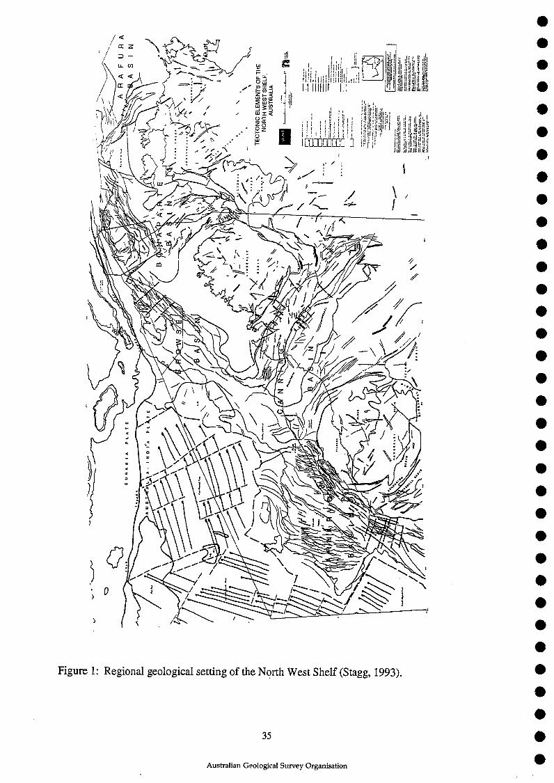
11•1
11,,
EU
RA
S IA
P
LA
TE
.4*
‘^\ I
1,1/
.,, \^
• ',
..1^
I•
N.
`1 /
-^I
Id•,
••
•
TECTO
NIC
ELE
MEN
TS O
F TH
EN
ORTH
WEST
SH
ELF
,AU
STR
ALI
A
L-1
N.1
• • •
• • •
• • •
• • •
• • •
• • •
• • •
• • •
411 •
• • •
• • •
• •

Figure 2: Regional seismic lines in the offshore Canning Basin. Lines shown with shot-pointsymbols in the southwest are AGSO Survey 110 (SNOWS-2); lines with shot-point symbolsnorth of 180 S are AGSO Survey 95 ('Triassic Reefs' project); remaining lines (no shot-pointsymbols) are Japan National Oil Corporation 1987 and 1988 surveys.
36
Australian Geological Survey Organisation

15
re
en%
.'-
--■
r-C-- S
cott
Plat
eau
15 I
X O
E
-_r-
Arg
o A
byss
al P
lain
MO
OM
OU
E
10 e
n 11
19—^
.0-c
ouw
e^4.
4A.v
ely,
i+^
—18
Si O
M
040
00r•-
---T
hili
tioz
+',i
.^
+m
oo
11 ^
I
•___
•c,1
0^.4
1-1s
ar m
aw I
+w
ar^
Im
4)
cd • —••■
. a0
, ,71
5+
ma
t I
•0"i-
c),,-
^
.11^.
^
--^20
0
10 m
ins
X r41 0
0Z S
IMI
+ V
rtki
kot r
as+
44
.31
I^
4:6a
me
I+
Am
?t^
I
sALIM
IP ?
+ta
me
sI
•T
s 1^
1
+m
aw
t^
+so
rra
TR
U 1
4)-I
ssan
asi I
+ra
sa I
44
01.
1w•a
ule
3148
81i1
8H
IM I
.41
120/
E1:1
1AM
UN
T I^
4.^
tOn
tall
ant
14:
14ga
l*".
..9RI
M N
NW 1
4..
.m i
44
E g
r I
•W
HIZ
MO
H I
+m
a t
+CaL
MO
ITV
INIk
klk
1
29
SI
NS
+m
azy
11^
1a
.....1"
••-..
+MO
OI
I m
an
2a S
I B
MIX
E^11
9 X
I N
E12
9 O
a am
122
NI
EX^
122
St11
7 XI
etE
• •
• •
• •
• •
• •
• •
• •
• •
• • •
• • •
• • •
• • •
• •

Are
a of
kn
own
Tri
assi
c re
efs
and
hig
h-r
esol
uti
ond
etai
led
sei
smic
su
rvey
Are
a of
pre
sum
ed J
ura
ssic
ree
fs
Sei
smic
sec
tion
-OD
D-
Bat
hym
etri
c co
nto
ur
(m)
95
/6
B
MR
cru
ise 9
5 s
eis
mic
pro
file
•2
8
MR
cru
ise 9
5 d
red
ge h
au
l
0 P
etr
ole
um
exp
lora
tio
n w
ell;
OD
P d
rillh
ole
0
BM
R c
ruis
e 9
6 d
red
ge
hau
l
• •
• •
• •
• •
• •
• •
• •
• •
• •
• •
• •
• •
• •
• •
• •
• •
• •
F.D3 0 0 ao
CA)
Cr)^
00
Fo ‘.< ao 4 0

77-
1500
085
113 O
S ON
1800
005
005
113 N
I ON
=111
• • •
• • •
• • •
• • al
• • •
• • •
• • •
• • •
• • •
• • •
• • •
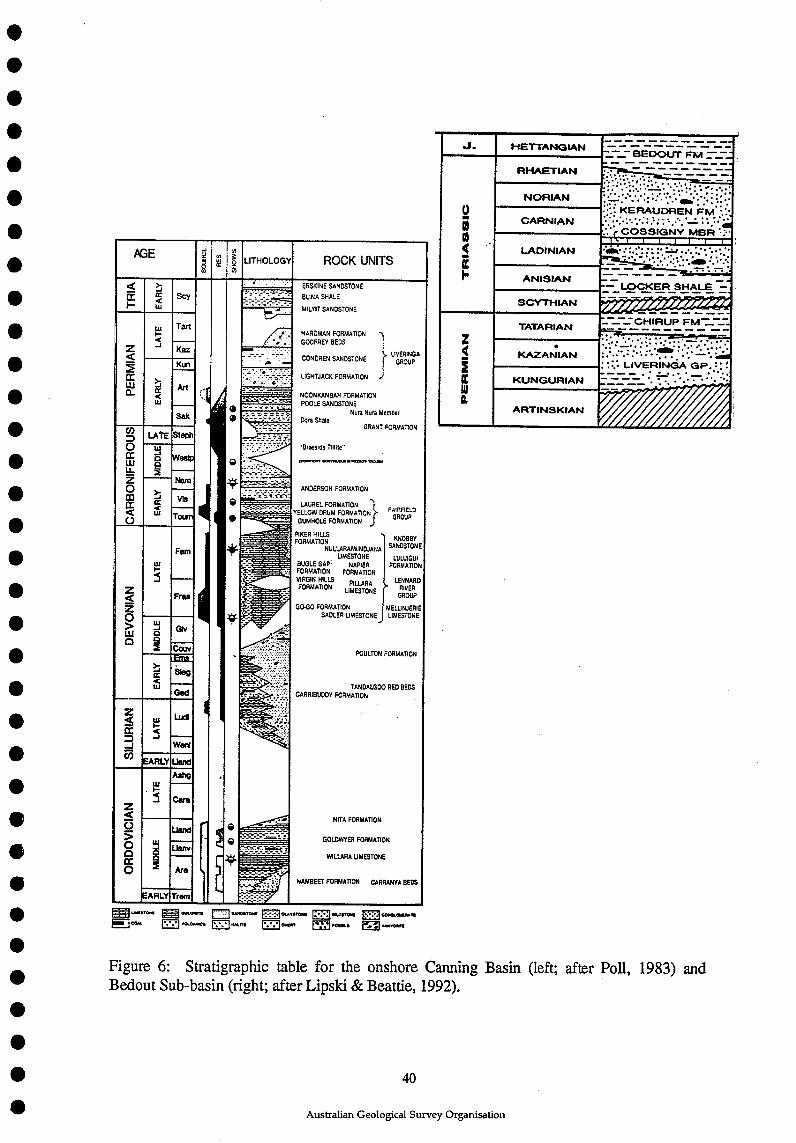
•
•
• Bedout Sub-basin (right; after Lipski & Beattie, 1992).Figure 6: Stratigraphic table for the onshore Canning Basin (left; after Poll, 1983) and
=13.owrom Ejounrce. 5121 WTSTONII
Caen Ezzi MM.215I FiCC-1COMI.CUMAITI
ulon,M11
•••
AGE u,^.w^LITHOLOGY^ROCK UNITS
>.-1
Ii.!
ERSKINE SANDSTONE
1.-' -^BLINA SHALE
---.---1-:- ----•-^MILYIT SANDSTONE
HARDMAN FORMATIONGODFREY BEDS
LivERinonGROUP
Z<
CCLII
F-<-J
Tart
KazCONDREN SANDSTONE
>.-.1ui
KunLIGHTJACK FORMATION
Art --^___________ ^NOONKANBAH FORMATIONPOOLE SANDSTONECBMGBenegr_
Sak Nera Nura Member• MEM Dora Shale
• ITIMM^ GRANT FORMATIONCOD0IliU-Z003CC<0
uktE StePh"Braeside Tillile"
MOM. GOVII0"11111.1131.110.■
--- -
CC a
90 West
Nern
Vie101111
›..-,
470- ANDERSON FORMATION
0 ^— ^LAUREL FORMATION FiggWMigil_^YELLOW DRUM FORMATION^FAIRFIELD-----7-4"^GUMHOLE FORMATION^J^GROUP
PIKER HILLSFORMATION
^7:7E-t7-a.^NULLARAMINDJANA=--,^ ,--ir-7,1,•_^UMESTONE
•EF•7--.=-E•-.Bi.^BUGLE GAP^NAPIERFORMATION^FORMATIONVIRGIN HILLS^PILLARAFORMATION^LIMESTONE
GO-GO FORMATIONSADLER LIMESTONE
=.716.V.'
-^POULTON
- i"Y. :-=̂
TANDALGOOCARRIBUDDY FORMATION
•
KNOBBYSANDSTONE
LULUIGUIFORMATION
LENNARDRIVER
GROUP
MELLINJERIELIMESTONE
FORMATION
RED BEDS
Z<Z0>LLIC1
LUI-5
Fam
_._...
Fru
1.'. Ij0g2
MI
Couv------
›--ICC<LU
•slog
Gad
Z<■•••cc=-I0
tO1.■5 ___ %,.." .11^
NITA FORMATION
Wad
EARLY hand
Z<0>
CC0
toI-S
Ash;
Care
g -.•-..2
ii -^ --:^GOLDWYEFI FORMATION
AreWILLARA LIMESTONE4. • -7.-=-=- •• Z•-• - •=-7.-
J- - -_^NAMBEET FORMATION^CARRANYA BEDS
TramEARLY
- HETTANGIAN^--- - -- -- - --_-- BEDOUT FM —
RHAETIAN- -- -- _- --^
NORIAN•••••
..•^•^. •2 CARNIAN
.::: KERAUDREN FM".•••••'.'::.1 ::'•^.......:.::::•tb •• COSSIGIVN; MBA t:-
0 Ift LAOIN1AN
.
CI —^• - • -ANISIANI. _ - -- - -
-^-7...LOCKER SHALE --
SCYTHIAN
TATARIAN
Z .It ICAZANIAN
2C KUNGUFIIANIII
ARTINSKIAN r - A1
••••••••••••••••••••••
•••^40•^Australian Geological Survey Organisation

Figure 7: Proposed SNOWS-3 seismic lines overlain on bathymetry. Lines shown with shot-point symbols are existing AGSO Survey 95 and Survey 110 data. Lines shown with theprefix 'BB-' are lines to be shot on the Browse Basin deep-seismic survey (Symonds, 1993).
41
Australian Geological Survey Organisation
••
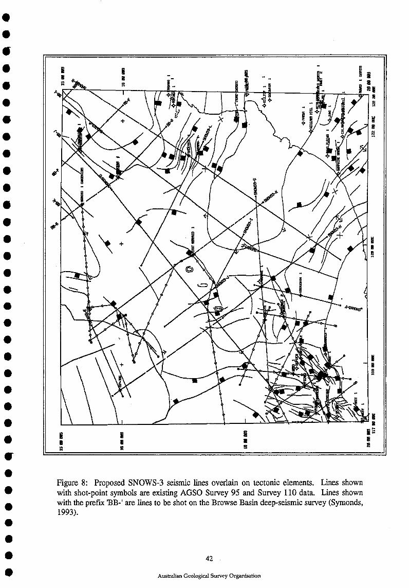
Figure 8: Proposed SNOWS-3 seismic lines overlain on tectonic elements. Lines shownwith shot-point symbols are existing AGSO Survey 95 and Survey 110 data. Lines shownwith the prefix 'BB-' are lines to be shot on the Browse Basin deep-seismic survey (Symonds,1993).
42
Australian Geological Survey Organisation