Augmented reality and perception of analogue and digital...
31
Augmented reality and perception of analogue and digital images and maps Piotr A. Werner Spatial Information Systems Laboratory Faculty of Geography & Regional Studies University of Warsaw Warsaw, Poland email: [email protected]
Transcript of Augmented reality and perception of analogue and digital...

Augmented reality and perception of analogue and digital images and maps
Piotr A. Werner
Spatial Information Systems Laboratory
Faculty of Geography & Regional Studies
University of Warsaw
Warsaw, Poland
email: [email protected]
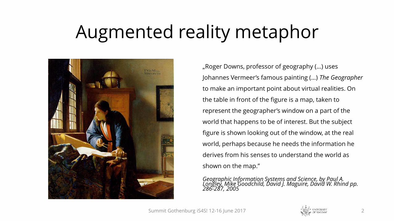
Augmented reality metaphor
„Roger Downs, professor of geography (…) uses
Johannes Vermeer’s famous painting (…) The Geographer
to make an important point about virtual realities. On
the table in front of the figure is a map, taken to
represent the geographer’s window on a part of the
world that happens to be of interest. But the subject
figure is shown looking out of the window, at the real
world, perhaps because he needs the information he
derives from his senses to understand the world as
shown on the map.”
Geographic Information Systems and Science, by Paul A. Longley, Mike Goodchild, David J. Maguire, David W. Rhind pp. 286-287, 2005
Summit Gothenburg iS4S! 12-16 June 2017 2

Printed map is yet important but there is rising challenge of growing use of mobile (digital) maps.
Courtesy, students of University of Warsaw, May 2016
Facebook, courtesy, B.Murgante, November 2015
Summit Gothenburg iS4S! 12-16 June 2017 3

• Maps, as spatial notations of the reality surrounded us, are linked to the process of
civilization changes since the earliest times…
• … the question of map ontogenesis is the question of human-milieu relation. Optimal
solution of this issue results from integrated human structures: somatic,
psychological and mental, revealing during the actions in the environment, including
also the creative and useful role of vision of the map.
• (…) map (…) is oriented information entity based on unity of three concepts: system
(target), model (information) and image (transmission) tria iuncta in uno.
Source: T.Chrobak, December 2015
Definition of map is changing
Discussion about digital map and its usefulness in information society
(Commission of Geoinformatics, Polish Academy of Arts and Sciences)
Summit Gothenburg iS4S! 12-16 June 2017 4
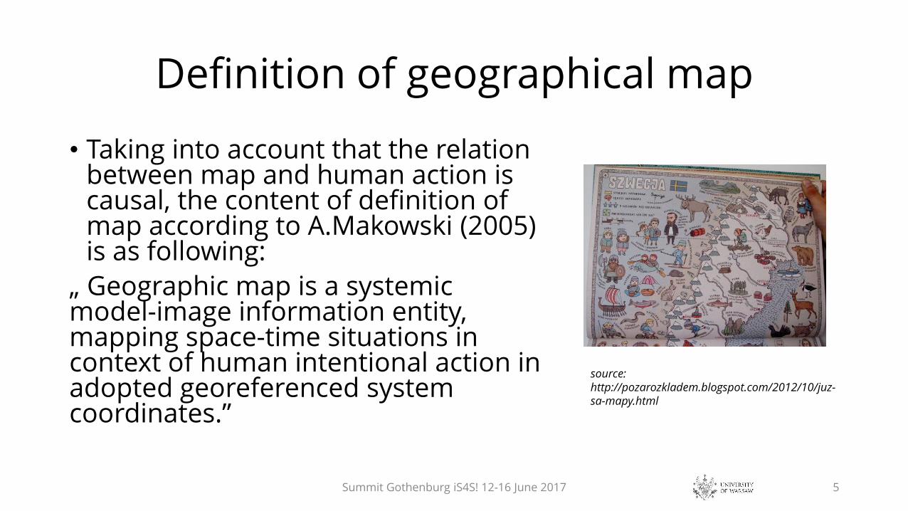
Definition of geographical map
• Taking into account that the relation between map and human action is causal, the content of definition of map according to A.Makowski (2005) is as following:
„ Geographic map is a systemic model-image information entity, mapping space-time situations in context of human intentional action in adopted georeferenced system coordinates.”
Summit Gothenburg iS4S! 12-16 June 2017 5
source: http://pozarozkladem.blogspot.com/2012/10/juz-sa-mapy.html

Geospatialdatabase
Printed Map2D
Mobile Map2D+T [A/I]
Visualization of digital map /computer/
2D, 2D+T, 2D+H, 2D+H+T, 3D, 3D+T, [A/I]
SciVis: Geovisualizations, Multimedia Maps
2D, 2D+T, 2D+H, 2D+H+T, 3D, 3D+T, [A/I]
Orthophotomap [A/I]
Virtual Globe3D [A/I]
Map instances
Summit Gothenburg iS4S! 12-16 June 2017
Legend:
2D, 3D: spatial dimensions
T: time
H: height/depth
A: animation
I: interaction
SciVis: scientific visualization
Source (overworked & changed):
T.Chrobak, 2015
P.J.Kowalski, 2014
6

Analogue map (hardcopy - printed paper map)
• Almost all map instances characterize interaction and feedbacks
to geospatial database.
• They make possible update of the digital maps, but only hardcopy i.e.
printout of map is finished product and seems completely separated from
mother, geospatial database.
• Update of hardcopy needs restart of the whole production process, and the
feedback with geospatial database is limited or does not exist.
• Interaction of hardcopy with digital devices is minimal…
Summit Gothenburg iS4S! 12-16 June 2017
Field /teren/Acquisition
/pozyskiwanie/Archiving
/archiwizacja/Analysis /analiza/
Display /mapa na ekranie/
Print /druk/
Classic processing of spatial data in Geographic Information Systems
7

Hardcopy (printed paper map)
• People still buy and use printed (paper) maps, despite of the digital technologies
expansion. They still buy and read newspapers, books or display their scans on digital
devices.
• „the separate problem is fact, that during the travel using GPS device, the large number of users come
to conclusion, that paper map may (and absolutely should in any case), calmly lie in a backpack. The
GPS information completely support orientation in the hardest terrain. Even if the digital map is not
very detailed in the device or presents only the waypoints.”
source: http://www.gpsmaniak.com/new/mapy-papier.htm
Summit Gothenburg iS4S! 12-16 June 2017 8
Image: MapBox/OpenStreetMap contributorsThe million-plus amateur cartographers who
volunteer their time to plot roads, streets, and even shrubbery…

Analogue map (hardcopy, printed map)
If paper map yet is not the niche product, one should at leastattempt to diagnose the several reasons of this situation:
• First habits, shaped during the curricular and extracurriculareducation i.e. formal and tacit knowledge of printed maps,atlases and guidebooks…
• Second lack of WiFi or GPS signal (regardless of reason)…
• Third lack of knowledge and skills which make possible a vistageneration of digital (professional) map by the users fromaccessible sources in net and ever more widely available softwareand geolocation tools.
Summit Gothenburg iS4S! 12-16 June 2017 9
West Greenland – the marginal zone of the inland-ice near ArfersiorfikfiordFirst Polish Greenland expedition 1937 of the Geographical Society in Lviv (Lwów)

Analogue map (hardcopy, printed map)/continued/If paper map yet is not the niche product, one should at least attempt to diagnose the severalreasons of this situation:
• Fourth psychological human mechanism belief in „durability” of printed image, which isavailable any time without additional equipment…
• Fifth hardcopy, printout map documents the state of real world in defined point of time andmay be the proof (according to law) to any public or individual decisions, actions, projects andclaims…
…
• N-th one can enumerate the several other reasons (I have, for sure, omitted them), e.g.
• Historical documentation…
• Aesthetical values of map as the work of art.
• etc…
Summit Gothenburg iS4S! 12-16 June 2017 10
Pieniny Mountains – tourist mapPolish Military Geographical Institute,
1937
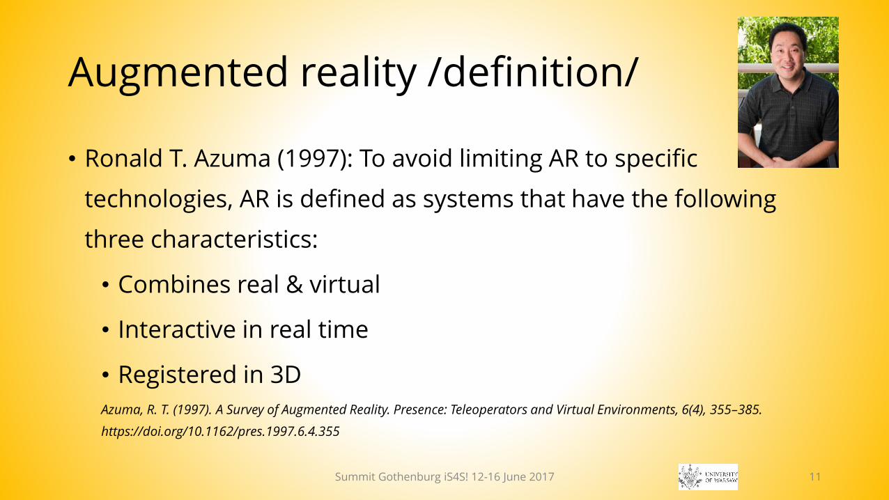
Augmented reality /definition/
• Ronald T. Azuma (1997): To avoid limiting AR to specific
technologies, AR is defined as systems that have the following
three characteristics:
• Combines real & virtual
• Interactive in real time
• Registered in 3D
Azuma, R. T. (1997). A Survey of Augmented Reality. Presence: Teleoperators and Virtual Environments, 6(4), 355–385.
https://doi.org/10.1162/pres.1997.6.4.355
Summit Gothenburg iS4S! 12-16 June 2017 11

Augmented Reality AR
• AR is dynamic overlay of digital, virtual
images and information concerning real
environment, which is observed.
• Images and virtual information change
constantly while observer is moving.
• AR means to integrate synthetic information
into the real environment.
• The overlay of spatially-registered computer
graphics over a live image of the real-world
Summit Gothenburg iS4S! 12-16 June 2017 12
Traugutta St. in Warsaw, Poland: now and before 1915

AR application (according to Pardel,2009)• Geolocation – GPS: Geographic Information Systems, Location Based Services marine & air traffic,
• Security and military applications,• Interactive maps: display & interactive analysis of terrain, interactive 3D
maps, landscape visualizations,• Building Information Modeling (BIM): visualization & modeling of buildings
and urban fabric,• Support for visitors: displaying tags & labels of observed objects,• Simulations: flight & drive simulators,• Virtualization of conferences,• Entertainment & education,• Newest: Google graphics geolocation using images of terrain objects search by images
Summit Gothenburg iS4S! 12-16 June 2017 13
Ponte Luís I, Porto, Portugal

AR classification• Two different augmented reality display concepts exist to superimpose
graphics onto the user’s view of the real world:
• Video see-through and optical see-through head-mounted displays (HMD) have
been the traditional output technologies for augmented reality applications for
almost forty years.
• SAR spatial augmented reality approach
• New display paradigms exploit large spatially-aligned optical elements, such as mirror
beam combiners, transparent screens, or holograms, as well as video projectors.
• In many situations, SAR displays are able to overcome technological and
ergonomic limitations of conventional AR systems
Bimber, O., & Raskar, R. (2005). Spatial augmented reality merging real and virtual worlds. Norwood Mass.
Summit Gothenburg iS4S! 12-16 June 2017 14
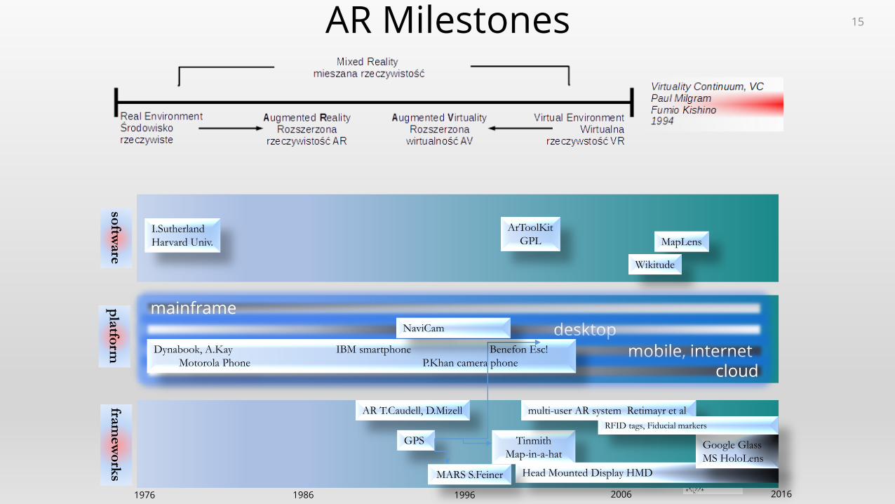
desktop
software
platform
frameworks
20161986 19961976 2006
I.Sutherland
Harvard Univ.
AR T.Caudell, D.Mizell
mainframe
mobile, internet cloud
Dynabook, A.Kay IBM smartphone Benefon Esc!
Motorola Phone P.Khan camera phone
GPS Tinmith
Map-in-a-hat
ArToolKit
GPL MapLens
Wikitude
NaviCam
Head Mounted Display HMD
Google Glass
MS HoloLens
multi-user AR system Retimayr et al
RFID tags, Fiducial markers
MARS S.Feiner
AR Milestones 15
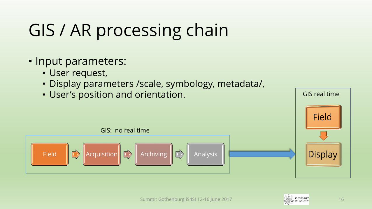
GIS / AR processing chain
• Input parameters:• User request,• Display parameters /scale, symbology, metadata/,• User’s position and orientation.
Field Acquisition Archiving Analysis
GIS: no real time
GIS real time
Summit Gothenburg iS4S! 12-16 June 2017 16

Combination of GIS & AR
Indoor/Outdoor exploration of geographical data.
Augmented Map (AM) Exploration of geospatial data directly from real or
virtual (digital) world Augmented Virtuality.
Augmented Territory (AT) additional information during exploration of
natural (or anthropogenic) environment Augmented Reality
These types are designed and implemented into applications (e.g. GPS navigation).
Bimber, O., & Raskar, R. (2005). Spatial augmented reality merging real and virtual worlds. Norwood Mass
Summit Gothenburg iS4S! 12-16 June 2017 17

How to include hardcopies (printed paper maps) into to chain of digital world?
• So far AR predominantly is related with mobile (digital) maps and there are
„few practical applications” (except navigation)
• Ann Morrison (2011) experimented with augmented reality (AR) using a magic
lens over a paper map using smartphones.
• „Maps are one of the main application categories for mobile AR. The focus is in
augmentation of physical maps with useful and interesting real-time information.
Paper maps have a large static surface and AR can provide a see-through lens
without forcing the user to watch map data only through the small `keyhole` of
the display”
Morrison, A. et al. (2011). Collaborative use of mobile augmented reality with paper maps. Computers & Graphics, 35(4), 789–799. http://doi.org/10.1016/j.cag.2011.04.009
Summit Gothenburg iS4S! 12-16 June 2017 18

Some findings…
• … points out, that type and layout of physical map
undergone augmented reality operation (augmented map)
affect its efficiency while using mobile devices (through
spatial pattern analysis and ways of users’ interaction).
• „…technical difficulties have mostly prevented (…) studies of outdoor AR use in uncontrolled environments.”
• „The maps act as mediation objects for multimodal discourses providing resources such as a context and facilitation for embodied communication.”
Summit Gothenburg iS4S! 12-16 June 2017 19
source: Morrison, A. et al. (2011) Collaborative use of mobile augmented reality with paper maps. Computers & Graphics, 35(4), 789–799. http://doi.org/10.1016/j.cag.2011.04.009
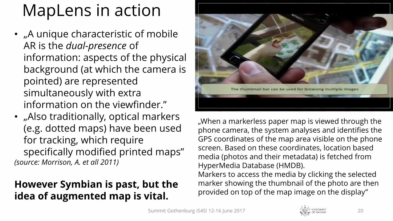
MapLens in action
Summit Gothenburg iS4S! 12-16 June 2017 20
• „A unique characteristic of mobile AR is the dual-presence of information: aspects of the physical background (at which the camera is pointed) are represented simultaneously with extra information on the viewfinder.”
• „Also traditionally, optical markers (e.g. dotted maps) have been used for tracking, which require specifically modified printed maps”
(source: Morrison, A. et all 2011)
However Symbian is past, but the idea of augmented map is vital.
„When a markerless paper map is viewed through thephone camera, the system analyses and identifies the GPS coordinates of the map area visible on the phone screen. Based on these coordinates, location based media (photos and their metadata) is fetched from HyperMedia Database (HMDB). Markers to access the media by clicking the selectedmarker showing the thumbnail of the photo are thenprovided on top of the map image on the display”

Other examples… LBS games ≡ geocaching ≡ orienteering?
Summit Gothenburg iS4S! 12-16 June 2017 21
Instruments: smartphone, GPS, application; map, compass /source: Wikipedia/

Yet another example… not exactly but almost paper…
• Avenza PDF map (http://www.pdf-maps.com)
Summit Gothenburg iS4S! 12-16 June 2017 22

Gartner Identifies the Top Strategic Technology Trends
Summit Gothenburg iS4S! 12-16 June 2017 23
Gartner 2012 Gartner 2016
connected world merging the physical and virtual
worlds
interface trends emergence of the digital mesh
analytical advances algorithmic business
new digital frontiers new IT reality, the new architecture
and platform
Gartner 2017
Artificial Intelligence and Advanced Machine Learning
Intelligent Apps
Intelligent Things
Virtual Reality and Augmented Reality
Digital Twins
Blockchains and Distributed Ledgers
Conversational Systems
Mesh App and Service Architecture
Digital Technology Platforms
Adaptive Security Architecture

Gartner's 2016 Hype Cycle for Emerging Technologies
Summit Gothenburg iS4S! 12-16 June 2017 24

Types of Mobile Augmented Realitysource: Khan, A. et al. (2015). Rebirth of Augmented Reality-Enhancing Reality via Smartphones. Bahria University Journal of Information & Communication Technology, 8(1), 110.
Marker based AR
Indoor applications• Template markers• 2D barcodeThis reality type uses visual marker known as fiducial or AR card to determine center, orientation and range of coordinate system. The system detect marker, identify and calculate pose of the object with help of computer vision techniques
Marker-less/Gravimetric AR
Outdoor applications
• Marker-less AR utilizes GPS (geopositioning), compass and other related sensors
• Augmented reality browsers help users to navigate between POIs (Point of Interests) appear on camera view for exploring AR contents based on location and context.
Summit Gothenburg iS4S! 12-16 June 2017 25
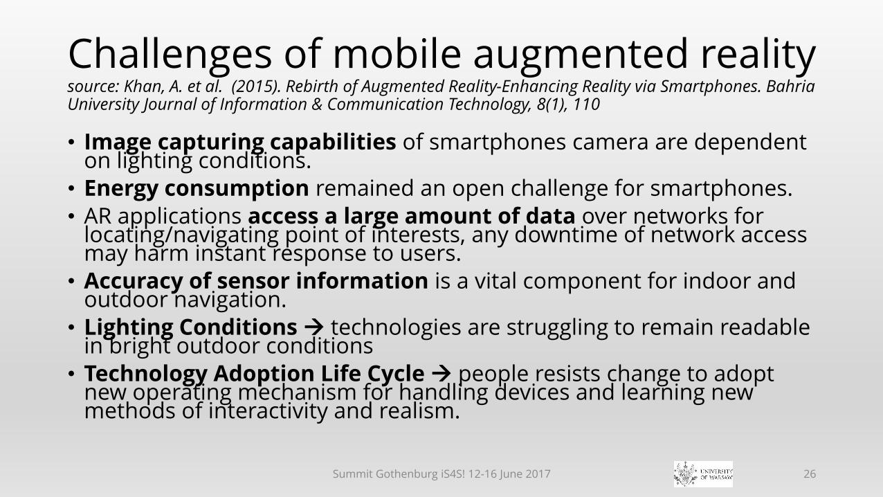
Challenges of mobile augmented realitysource: Khan, A. et al. (2015). Rebirth of Augmented Reality-Enhancing Reality via Smartphones. Bahria University Journal of Information & Communication Technology, 8(1), 110
• Image capturing capabilities of smartphones camera are dependent on lighting conditions.
• Energy consumption remained an open challenge for smartphones.
• AR applications access a large amount of data over networks for locating/navigating point of interests, any downtime of network access may harm instant response to users.
• Accuracy of sensor information is a vital component for indoor and outdoor navigation.
• Lighting Conditions technologies are struggling to remain readable in bright outdoor conditions
• Technology Adoption Life Cycle people resists change to adopt new operating mechanism for handling devices and learning new methods of interactivity and realism.
Summit Gothenburg iS4S! 12-16 June 2017 26

Does the digital era herald the end of history?source: http://www.bbc.com/news/technology-32315449 [Accessed 27 April 2015]
• The loss of this data could plunge the world into a "digital dark age", warns "father of the internet" Vint Cerf - one of the inventors of the net's language and architecture.
• Most of our photos, videos, conversations, research and writings are now stored as strings of ones and noughts - distributed throughout the world. [And after all maps!!! Auth.]
•An electromagnetic pulse (EMP) …, could easily wipe out entire electricity networks and effectively bring civilisation to a crashing halt.
• We're only just beginning to understand how important this data is and what the consequences might be if we lost it
Summit Gothenburg iS4S! 12-16 June 2017 27

Target: inclusion of paper map or analogue image into the chain of digital devices use
• If there is no mobile operator coverage ...
• If there is no wireless coverage ...
• If for any reason there is no GPS signal on the smartphone ...
• But, the battery is still charged; and in the pocket a paper(augmented) map; and maybe a compass (analogue) on thewatch strap ¡
Summit Gothenburg iS4S! 12-16 June 2017 28
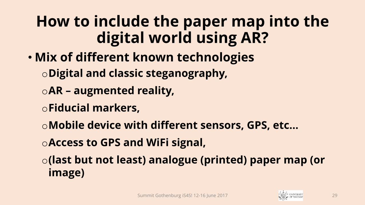
How to include the paper map into the digital world using AR?
• Mix of different known technologies
oDigital and classic steganography,
oAR – augmented reality,
oFiducial markers,
oMobile device with different sensors, GPS, etc…
oAccess to GPS and WiFi signal,
o(last but not least) analogue (printed) paper map (or image)
Summit Gothenburg iS4S! 12-16 June 2017 29
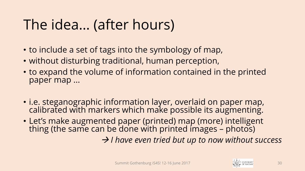
The idea… (after hours)
• to include a set of tags into the symbology of map,
• without disturbing traditional, human perception,
• to expand the volume of information contained in the printed paper map ...
• i.e. steganographic information layer, overlaid on paper map, calibrated with markers which make possible its augmenting.
• Let’s make augmented paper (printed) map (more) intelligent thing (the same can be done with printed images – photos)
I have even tried but up to now without success
Summit Gothenburg iS4S! 12-16 June 2017 30
Thank You for patience and audience
Summit Gothenburg iS4S! 12-16 June 2017 31


![Mutative Media, IT, Social Power - Changing Reality through media perception [virtual and augmented reality]](https://static.fdocuments.net/doc/165x107/55ad6a411a28ab1f718b4892/mutative-media-it-social-power-changing-reality-through-media-perception-virtual-and-augmented-reality.jpg)