Attachment E, Riparian Vegetation Study Downstream of the
32
Attachment E Riparian Vegetation Study Downstream of the Proposed Susitna-Watana Dam (February 2013)
Transcript of Attachment E, Riparian Vegetation Study Downstream of the

Attachment E Riparian Vegetation Study Downstream of the Proposed Susitna-Watana Dam (February 2013)

Susitna-Watana Hydroelectric Project
(FERC No. 14241)
Riparian Vegetation Study Downstream of the
Proposed Susitna-Watana Dam
Prepared for
Alaska Energy Authority
Prepared by
ABR, Inc.—Environmental Research & Services
February 2013

FINAL REPORT RIPARIAN VEGETATION
Susitna-Watana Hydroelectric Project Alaska Energy Authority FERC Project No. 14241 Page i February 2013
TABLE OF CONTENTS
1. Introduction ........................................................................................................................1
2. Study Objectives.................................................................................................................1
3. Study Area ..........................................................................................................................2
4. Methods ...............................................................................................................................2
4.1. Deviations from the 2012 Study Plan ......................................................................2
4.2. Geomorphic Units, Vegetation Types, and Soils .....................................................3
4.3. Historic Vegetation Plots .........................................................................................4
4.4. Integrated Terrain Unit Mapping .............................................................................5
5. Results .................................................................................................................................5
5.1. Geomorphic Units, Vegetation Types, and Soils .....................................................5
5.2. Additional Observations ..........................................................................................6
5.2.1. Ice Processes ............................................................................................ 6
5.2.2. Beaver Activity ........................................................................................ 6
5.3. Historic Vegetation Plots .........................................................................................6
5.4. Integrated Terrain Unit Mapping .............................................................................6
6. Discussion............................................................................................................................7
7. References ...........................................................................................................................8
8. Tables ................................................................................................................................10
9. Figures ...............................................................................................................................14
LIST OF TABLES
Table 1. Descriptions of common geomorphic units sampled in the Riparian Vegetation Study
area, Susitna River floodplain, Alaska, 2012. ....................................................................... 11
Table 2. Descriptions of common Viereck et al. (1992) Level IV vegetation classes sampled in
the Riparian Vegetation Study area, Susitna River floodplain, Alaska, 2012. ..................... 12
Table 3. Descriptions of common soil subgroups sampled in the Riparian Vegetation Study area,
Susitna River floodplain, Alaska, 2012. ............................................................................... 13

FINAL REPORT RIPARIAN VEGETATION
Susitna-Watana Hydroelectric Project Alaska Energy Authority FERC Project No. 14241 Page ii February 2013
LIST OF FIGURES
Figure 1. Study area and locations of completed 2012 field study plots for the Riparian
Vegetation Study, Susitna-Watana Hydroelectric Project, Alaska. ...................................... 15
Figure 2. Open Balsam Poplar Forest showing the sapling (left) and timber (right) successional
stages, Riparian Vegetation Study area, Susitna River floodplain, Alaska, 2012. ............... 16
Figure 3. Open Spruce–Paper Birch forest, Riparian Vegetation Study area, Susitna River
floodplain, Alaska, 2012. ...................................................................................................... 17
Figure 4. Large Umbel Meadow, Riparian Vegetation Study area, Susitna River floodplain,
Alaska, 2012. Vegetation in photo is approximately 1.5–2.0 meters (4.9–6.6 feet) tall....... 18
Figure 5. Typic Cryofluvents at a river bank exposure, Riparian Vegetation Study area, Susitna
River floodplain, Alaska, 2012. ............................................................................................ 19
Figure 6. Oxyaquic Cryorthents on an active cobble bar showing water table at 35 centimeter
(14 inches) below soil surface, Riparian Vegetation Study area, Susitna River floodplain,
Alaska, 2012. ........................................................................................................................ 20
Figure 7. Ice scar on balsam poplar, Riparian Vegetation Study area, Susitna River floodplain,
Alaska. Scientist in photo is ~1.9 meter (6.2 feet) tall. ......................................................... 21
Figure 8. Recent ice gouging and ice bull-dozing on a mid-river gravel bar, Riparian Vegetation
Study area, Susitna River, Alaska, 2012. .............................................................................. 22
Figure 9. Aerial view of beaver pond complex, Riparian Vegetation Study area, Susitna River
floodplain, Alaska, 2012. ...................................................................................................... 23
Figure 10. Beaver impoundment showing older, vegetated dam with breach recently maintained
by beavers, Riparian Vegetation Study area, Susitna River floodplain, Alaska, 2012. ........ 24
Figure 11. ITU mapping area within the Riparian Vegetation Study area, Middle Susitna River,
Alaska, 2012. ........................................................................................................................ 25

FINAL REPORT RIPARIAN VEGETATION
Susitna-Watana Hydroelectric Project Alaska Energy Authority FERC Project No. 14241 Page iii February 2013
LIST OF ACRONYMS AND SCIENTIFIC LABELS
Abbreviation Definition
AEA Alaska Energy Authority
ALA University of Alaska Museum of the North Herbarium
AVC Alaska Vegetation Classification
cm centimeter
EC electrical conductivity
ELS Ecological Land Survey
FERC Federal Energy Regulatory Commission
ft feet/foot
GIS Geographic Information System
GPS global positioning system
ha hectare(s)
in inch(es)
ILP Integrated Licensing Process
ITU Integrated Terrain Unit
m meter(s)
mm millimeter(s)
Mat-Su Matanuska-Susitna Borough
NEPA National Environmental Policy Act
NRCS Natural Resources Conservation Service
Project Susitna-Watana Hydroelectric Project
RIFS Riparian Instream Flow Study
RM river mile
USDA U.S. Department of Agriculture

FINAL REPORT RIPARIAN VEGETATION
Susitna-Watana Hydroelectric Project Alaska Energy Authority FERC Project No. 14241 Page iv February 2013
EXECUTIVE SUMMARY
The data collected for this study, in combination with the data collected for the Riparian Instream
Flow Study (RIFS), will provide the baseline information from which predictive models will be
developed to assess likely changes in riparian ecosystems downstream of the proposed dam. A
thorough understanding of how the proposed Project activities would affect hydrologic processes
and riparian ecosystems downstream of the dam will be critical for developing best-management
practices, assessing potential impacts to wildlife, and preparing adequate FERC documentation
of Project effects.
The Riparian Vegetation Study is designed as a multi-year study, with work to be conducted in
2012 through 2014. In 2012, the primary goals of the study were to perform reconnaissance-level
sampling to characterize local-scale riparian ecosystems (riparian ecotypes) downstream from
the proposed Watana Dam site and to begin the process of mapping riparian ecotypes, wetlands,
and wildlife habitats in the study area (see Figure 1). Specific objectives of the 2012 Riparian
Vegetation Study included:
Collect vegetation and soils data to characterize those physical and ecological processes
downstream from the Watana Dam site that are likely to affect riparian areas;
Collect field-verification data to facilitate the classification and mapping of riparian
ecotypes and wildlife habitat types in the study area;
Assess the feasibility of relocating historic (1980s and 1990s) vegetation sampling plots
in the Susitna River floodplain; and
Begin preliminary mapping of riparian ecotypes using an Integrated Terrain Unit (ITU)
approach.
Field work was conducted over a 10-day period between 23 June and 3 July 2012. Data were
collected at 87 field plots sampled along 28 transects (Figure 1). A total of 19 geomorphic units,
28 vegetation classes (Level IV of the Alaska Vegetation Classification [AVC]), and 15 soil
subgroups were sampled in the field. Evidence of ice effects in the floodplain were commonly
observed, including tree-bole scarring (up to 4–6 meters above ground level) on the upstream
side of trees, ice gouging and ice “bull-dozing” along banks and gravel bars, large displaced
stones, and “mowing” of vegetation. Beaver activity also was commonly recorded, including
chewed and felled trees and shrubs, dams and lodges, and impounded waterbodies.
Locations of the 30 historic vegetation sampling plots were digitized from the pin-pricks on the
original aerial images, converted into ArcGIS compatible format, and overlaid in a GIS on recent
aerial imagery of the Susitna River floodplain. Attempts to relocate several of these historic plots
by navigating to the general area using a hand-held GPS and searching for the wooden stake that
was placed to mark each plot were unsuccessful. Additionally, nine historic plots appeared to be
presently located in active river channels, either because of natural changes in the floodplain and
channel reconfiguration over time or spatial errors associated with the conversion of the
coordinates from the original aerial images to ArcGIS.
Lastly, preliminary ITU mapping of riparian ecotypes, by photointerpretation of recent aerial
imagery available for the study area, was conducted in 2012. The preliminary mapping area
includes a 2,580 ha (6,376 acre) section of the middle river between approximately river miles
118 and 141 (river miles from data collected in 1981). This stretch of the river is covered by the

FINAL REPORT RIPARIAN VEGETATION
Susitna-Watana Hydroelectric Project Alaska Energy Authority FERC Project No. 14241 Page v February 2013
Matanuska-Susitna Borough aerial imagery collected in mid- to late summer 2011. This imagery
provides the best color signatures for mapping since it was collected at full vegetation green-up.
As noted above, the ITU data collected in 2012 represent only the first year of work in a multi-
year mapping study for the Project. The data from 2012 will be combined with those collected in
2013 and 2014 to prepare complete ITU maps for the riparian areas in the Susitna River
downstream of the proposed dam site.
Of the 19 geomorphic units sampled in 2012, the most common were Braided Inactive Overbank
Deposit (n=19 occurrences), Meander Inactive Overbank Deposit (n=16), Braided Active
Overbank Deposit (n =15), Meander Active Overbank Deposit (n=6), and Braided Coarse Active
Channel Deposit (n=5).
Of the 28 Level IV AVC vegetation classes sampled in 2012, the most common were Open
Balsam Poplar Forest (n=12 occurrences), Open Spruce–Paper Birch Forest (n=7), Partially
Vegetated (n=6), Closed Balsam Poplar Forest (n=6), and Open Tall Alder Scrub (n=5). Less
common vegetation types included Large Umbel Meadow, Open Low Shrub Birch–Ericaceous
Shrub Bog, and Subarctic Lowland Sedge Meadow. The AVC provides a useful vegetation-
structure-based classification for Alaska. However, the AVC is not designed to classify early and
mid-successional vegetation communities. For example, a number of distinct early and mid-
successional plant communities were observed, and these would sometimes be classified within
one Level IV AVC vegetation class (e.g., Open Balsam Poplar Forest). To differentiate the full
range of early and mid-successional vegetation types on the Susitna River floodplain, some new
vegetation classes were created for this study based on the Level IV AVC classification system.
Of the 15 soil subgroups sampled in 2012, the most common were Typic Cryofluvents (n=19
occurrences), Oxyaquic Cryofluvents (n=12), Typic Cryorthents (n=5), Aquic Cryofluvents
(n=4), and Oxyaquic Cryorthents (n=4).

FINAL REPORT RIPARIAN VEGETATION
Susitna-Watana Hydroelectric Project Alaska Energy Authority FERC Project No. 14241 Page 1 February 2013
1. INTRODUCTION
The Alaska Energy Authority (AEA) is preparing a License Application that will be submitted to
the Federal Energy Regulatory Commission (FERC) for the Susitna-Watana Hydroelectric
Project (Project) using the Integrated Licensing Process (ILP). The Project is located on the
Susitna River, an approximately 300-mile-long river in Southcentral Alaska. The Project’s dam
site would be located at river mile (RM) 184.
The Riparian Vegetation Study is a multi-year effort, initiated in 2012. This report provides the
results of the 2012 work, as outlined in the 2012 Riparian Study plan (AEA 2012a). This study
provided data to inform the Revised Study Plan (RSP) filed with FERC in 2012 (AEA 2012b),
and will be incorporated into the Exhibit E of the License Application, and FERC’s National
Environmental Policy Act (NEPA) analysis for the Project license.
In 2012, reconnaissance-level field surveys were conducted, in close collaboration with the
Riparian Instream Flow Study (RIFS), to collect current data on vegetation and soils to (1)
characterize the baseline physical and ecological processes operating in riparian areas
downstream of the proposed dam site, and (2) provide ground-reference data for use in the
mapping of local-scale riparian ecosystems (riparian ecotypes) and wildlife habitats in the study
area (see Study Area below). Additionally, efforts were made to relocate historic (1980s)
sampling sites for the study of vegetation succession in the Susitna River floodplain (AEA
2011). After the field studies, in fall and winter 2012, the preliminary mapping of riparian
vegetation in the study area was initiated.
2. STUDY OBJECTIVES
Construction and operation of the proposed Project would alter the natural flow regime of the
Susitna River. The data collected for this study, in collaboration with the data collected for the
RIFS and the studies of groundwater, ice processes, and fluvial geomorphology downstream of
the proposed dam site, will provide the baseline information from which predictive models will
be developed to assess likely changes in riparian ecosystems downstream of the proposed dam.
A thorough understanding of how alternative operational scenarios for the Project would affect
hydrologic processes and riparian ecosystems downstream of the dam will be critical for
assessing potential impacts to riparian vegetation, wildlife habitats, and wetlands, and for
preparing adequate documentation of potential Project effects during the licensing process.
The primary goals of the Riparian Vegetation Study in 2012 were to perform reconnaissance-
level field sampling to characterize riparian ecotypes downstream from the Watana Dam site,
and to begin the process of mapping riparian ecotypes in the study area. Specific objectives of
the 2012 Riparian Vegetation Study included the following:
Collect vegetation and soils data to characterize the physical and ecological processes
downstream from the Watana Dam site that are likely to affect riparian areas;
Collect ground-reference data for use in the classification and mapping of riparian
ecotypes and wildlife habitat types in the Project study area;

FINAL REPORT RIPARIAN VEGETATION
Susitna-Watana Hydroelectric Project Alaska Energy Authority FERC Project No. 14241 Page 2 February 2013
Assess the feasibility of relocating the historic successional vegetation study plots studied
in the 1980s and 1990s (McKendrick et al. 1982; Helm and Collins 1997); and
Conduct preliminary mapping of riparian ecotypes using an Integrated Terrain Unit (ITU)
mapping approach.
The 2012 study plan for the Riparian Vegetation Study (AEA 2012a) described the objectives
and methods for mapping existing vegetation and wildlife habitats in riparian areas downstream
from the proposed dam. Since that time, in consultation with AEA and resource management
agencies, the mapping of wetlands has been added as an additional task for the Riparian
Vegetation Study (see RSP Section 11.6 in AEA 2012b).
3. STUDY AREA
In 2012, the study area included those downstream areas in which Project-induced changes to
flow and river levels (stage) were thought most likely to occur. For 2012, the study area extended
downstream from the proposed dam site to the town of Willow (RM 46), and laterally from
approximately the edge of flowing waters in the Susitna River to 200 meters into adjacent upland
terrain (Figure 1). In 2013-2014, the study area may be extended, both the downstream extent
and the lateral boundary, based on the results of the open-water flow routing model (R2 2013).
The final study area will be determined before the 2013 field season, as described in RSP Section
11.6 of AEA (2012b).
4. METHODS
Based on previous Ecological Land Survey (ELS) studies in Alaska (see Jorgenson et al. 2003),
riparian study plots were sampled along transects located in the Upper, Middle, and Lower
Susitna River Segments to collect detailed ground-reference data on site characteristics,
environmental variables, successional vegetation, and soils to facilitate the ITU mapping of
riparian ecotypes. After the field season in 2012, we used ITU methods (see Integrated Terrain
Unit Mapping below) to initiate the mapping of riparian ecotypes in the study area.
4.1. Deviations from the 2012 Study Plan
The 2012 study plan for the Riparian Vegetation Study indicated that preliminary mapping of
riparian ecotypes was to be conducted prior to the 2012 field season, time permitting. The
primary objective was to allow for field verification of the early-stage mapping of riparian
ecotypes. However, high-resolution imagery was not available for mapping until May 2012,
approximately one month prior to the commencement of field work. As a result, only preliminary
ITU mapping was conducted in 2012. In 2013 and 2014, however, the preliminary mapping of
riparian ecotypes, wildlife habitats, and wetlands will be completed for field verification in the
subsequent field seasons. Thus, the lack of completion of the preliminary mapping prior to, and
following the 2012 field surveys will not affect the quality or accuracy of final riparian ecotype,
wildlife habitat, and wetland maps.

FINAL REPORT RIPARIAN VEGETATION
Susitna-Watana Hydroelectric Project Alaska Energy Authority FERC Project No. 14241 Page 3 February 2013
4.2. Geomorphic Units, Vegetation Types, and Soils
In 2012, field work was conducted over a 10-day period from June 23–July 3. Transect locations
were stratified across the study area using a gradient-directed sampling scheme (Austin and
Heyligers 1989) to document the range of ecological conditions present and acquire the spatially
explicit data needed to interpret riparian ecosystem development. Intensive sampling was
conducted along toposequences (transects) stratified within three areas of the Susitna River: the
Middle River (upstream of the confluence with the Chulitna and Talkeetna rivers at
approximately RM 98), Lower River – Upper (between the Chulitna/Talkeetna confluence and
approximately RM 69), and Lower River – Middle (RMs 69 to 41). We avoided sampling
upriver of approximately RM 140 due to unresolved land access questions at the time of the
survey.
Data were collected at 87 study plots along 28 transects (Figure 1). Along each transect, 5–10
plots (approximately 10meter [33-foot] radius) were typically sampled, each in a distinct
vegetation type or image spectral signature identifiable on aerial photographs. Study plot
locations were selected subjectively by the field crew leader, choosing homogenous patches of
vegetation (~0.5 – 0.75 hectare, minimum area) and avoiding ecotones (areas of transition
between vegetation types). Plots were spaced to sample throughout the entire length of each
transect and avoid “pseudoreplication” (i.e., sampling the same or very similar vegetation and
soils in more than one plot on a single transect). Plot locations were pin-pricked on aerial
photographs/satellite imagery, and coordinates (including approximate elevations) were obtained
with global positioning system (GPS) receivers (accuracy ±5 meters [16 feet]). At each plot,
geology, hydrology, soil stratigraphy, soil chemistry, vegetation structure, and plant cover were
described or measured (see below). Digital photos were taken at each plot, including landscape
and groundcover views, and photos of the soil-pit face. At the end of the day, weather permitting,
a flyover of each transect was completed and an oblique aerial photograph of each study plot was
taken.
Geologic and surface-form variables recorded included physiography, geomorphic unit, slope,
aspect, surface form, and height of any microrelief. Hydrologic variables measured included
depth of water above or below ground surface, depth to saturated soil, pH, and electrical
conductivity (EC). Ground-surface variables included percent frost boils and surface fragments.
Water quality measurements (pH and EC) were made using Oakton portable meters that were
calibrated daily with standard solutions.
General soils data were collected from shallow soil plugs or pits (40–50 centimeters [16–20
inches] deep) at each plot. Soil data collected at each plot included depth to lithic contact, depth
of surface organic matter, cumulative thickness of all organic horizons, percent coarse fragments,
cumulative thickness of volcanic ash, cumulative thickness of loess, depth to upper boundary of
coarse fragments (>15 percent by volume), presence of cryoturbation, presence of effervescence
using a dilute acid solution, and depth of thaw (an indicator of calcium carbonate in soils). When
water was not present, EC and pH were measured from a saturated soil paste. Soil texture was
assessed by hand texturing, using a 2 millimeters (0.08 inches) mesh sieve to remove coarse
fragments. A single simplified texture (i.e., loamy, sandy, ashy, organic) was assigned to
characterize the dominant texture in the top 40 centimeters (16 inches) of soil at each plot for
ecotype classification.

FINAL REPORT RIPARIAN VEGETATION
Susitna-Watana Hydroelectric Project Alaska Energy Authority FERC Project No. 14241 Page 4 February 2013
A complete soil stratigraphy was described at 1 to 2 plots per transect. With the exception of the
depth requirements of soil pits, soil descriptions followed standard Natural Resources
Conservation Service (NRCS) protocols (Soil Survey Division Staff 1993, Schoeneberger et al.
2002). Soils were classified to the subgroup level using the 11th edition of the Keys to Soil
Taxonomy (Soil Survey Staff 2010). Soil pits for full stratigraphic descriptions were dug to at
least 50 centimeter (20 inches) plus the thickness of surface and buried organic layers combined
(see below), to a maximum depth of 70 centimeters (28 inches). In stratified soils (e.g.,
floodplains), stratifications were grouped into broader horizons and denoted as such with notes
describing the interbedded soil materials. Buried organic horizons ≥1.0 centimeters (0.4 inch)
thick were designated as unique horizons, while those horizons <1.0 centimeter (0.4 inch) were
grouped with adjacent mineral soils with descriptive notes included. At plots where complete soil
stratigraphy was not recorded, a rapid soil stratigraphy was recorded instead. Rapid soil
stratigraphy descriptions included horizon top and bottom depths, texture, and field horizonation.
Color and pH were recorded opportunistically if required for classification to soil subgroup.
Vegetation composition and structure data were collected semi-quantitatively (visual cover
estimates) for all vascular and dominant non-vascular plant species. In addition, data were
recorded for several specific categories of non-vascular plants, including percent Sphagnum
species, percent feathermoss, and percent combined Cladonia/Cladina species. If total live cover
of a species or category was <10 percent or >90 percent, the percent cover was visually
estimated to the nearest 1 percent. When total cover ranged between 10–90 percent, individual
cover values were estimated to the nearest 5 percent. Isolated individuals or species comprising
very low cover were assigned a cover value of 0.1 percent. Total cover of each plant growth
form (e.g., tall shrub, dwarf shrub, lichen) was estimated independently of the cover estimates
for individual species. Data were cross-checked in the field to ensure that the summed cover
value for individual species within a growth form category was similar to the total cover
estimated for that growth form. Vegetation structure type (e.g., Low Scrub, Broadleaf Forest)
and Alaska Vegetation Classification (AVC) Level IV vegetation class (Viereck et al. 1992) were
also recorded. Taxonomic nomenclature was based on Viereck and Little (2007) for trees and
shrubs, and Hultén (1968) for all other vascular taxa. Voucher specimens were collected for
verification of plants that were difficult to identify in the field. Dominant vascular species that
could not be identified in the field were sent for verification to Carolyn Parker, University of
Alaska Museum of the North Herbarium (ALA), Fairbanks. Nomenclature for bryophytes and
lichens followed the National Plants Database (USDA NRCS 2012). Identification of mosses and
lichens during field sampling was limited to dominant, readily identifiable species. Dominant
cryptogams that could not be identified in the field were collected and were sent to moss and
lichen experts at the Komarov Botanical Institute, St. Petersburg, Russia, for identification.
Tree cores of 1–2 individual trees (characteristic size, dominant species in stand) were collected
slightly above the root crown using an increment borer for use in aging forested stands and
geomorphic surfaces. In shrub stands, full stem sections including the root crown were collected
for aging.
4.3. Historic Vegetation Plots
Locations of the 30 historic (1980s) vegetation plots (henceforth referred to as historic vegetation
plots) from McKendrick et al. (1982) were digitized from the pin-pricks on the original aerial
images, converted into ArcGIS compatible format, and overlaid in a Geographic Information

FINAL REPORT RIPARIAN VEGETATION
Susitna-Watana Hydroelectric Project Alaska Energy Authority FERC Project No. 14241 Page 5 February 2013
System (GIS) on recent aerial imagery of the study area. Upon review of the locations, nine
historic vegetation plots appeared to be presently located in active river channels. This is
attributed to either (1) natural changes in the floodplain and channel configuration through time,
or (2) spatial errors associated with the conversion of the location coordinates from original
aerial images to ArcGIS. Of the remaining 21 historic vegetation plots, relocation of five plots
was attempted by navigating to the general area of each plot using a hand-held GPS and
searching for the wooden stake that was placed to mark each plot.
4.4. Integrated Terrain Unit Mapping
ITU mapping is an integrated approach to mapping landscape elements. It is a mulitvariate
mapping process in which the map polygon boundaries for terrain units or ITU variables are
adjusted so that there is increased coincidence between the boundaries and occurrences of
interdependent ITU variables such as geology, hydrography, physiography, soils, and vegetation
units (Jorgenson et al. 2003; 2009). The ITU mapping approach—to be used for the formal
2013–2014 Riparian Vegetation Study—is based on methods and concepts developed for ELS
studies conducted in tundra, boreal forest, and coastal regions in Alaska over the past 15 years
(see Jorgenson et. al. 2003 for an example study in Southcentral Alaska). The ITU mapping
approach to be used for the Riparian Vegetation Study will involve mapping terrain units such as
vegetation type, poplar size class (e.g., pole, timber, large timber), fluvial geomorphology, and
surface-form types (macrotopography and microtopography), and then combining them into
units with ecological importance (in this case riparian ecotypes, wetlands, and wildlife habitats).
More details on the methods to be used for the formal 2013–2014 Riparian Vegetation Study are
found in RSP Section 11.6 in AEA (2012b). In 2012, ITU methods were used to initiate the
mapping of riparian ecotypes in the study area.
5. RESULTS
5.1. Geomorphic Units, Vegetation Types, and Soils
A total of 19 geomorphic units were sampled during the 2012 field survey. The most common
types were Braided Inactive Overbank Deposit (n=19 occurrences), Meander Inactive Overbank
Deposit (n=16), Braided Active Overbank Deposit (n=15), Meander Active Overbank Deposit
(n=6), and Braided Coarse Active Channel Deposit (n=5). Definitions of the common
geomorphic units recorded in the study area are provided in Table 1.
A total of 28 AVC Level IV vegetation classes (Viereck et al. 1992; henceforth referred to as
Level IV vegetation classes) were sampled during the 2012 field trip. The most common types
were Open Balsam Poplar Forest (n=12 occurrences; Figure 2), Open Spruce–Paper Birch Forest
(n=7; Figure 3), Partially Vegetated (n=6), Closed Balsam Poplar Forest (n=6), and Open Tall
Alder Shrub (n=5). Definitions of commonly recorded Level IV vegetation classes are provided
in Table 2. Less common vegetation types included Large Umbel Meadow (Figure 4), Open Low
Shrub Birch–Ericaceous Shrub Bog, and Subarctic Lowland Sedge Meadow.
The AVC provides a useful vegetation-structure-based classification for Alaska. However, the
AVC is not designed to classify early and mid-successional vegetation communities. For
example, a number of distinct early and mid-successional plant communities were observed in

FINAL REPORT RIPARIAN VEGETATION
Susitna-Watana Hydroelectric Project Alaska Energy Authority FERC Project No. 14241 Page 6 February 2013
the field, and these would sometimes be classified within one Level IV vegetation class (e.g.,
Open Balsam Poplar Forest; see Figure 2). To differentiate the full range of early and mid-
successional vegetation types on the Susitna River floodplain, it was necessary to create some
new vegetation classes for this study. These new types were defined based on existing AVC
Level IV vegetation types and, for the early successional types, followed the types described by
Helm and Collins (1997).
A total of 15 soil subgroups (Soil Survey Staff 2010) were sampled during the 2012 field survey.
The most common types were Typic Cryofluvents (n=19 occurrences; Figure 5), Oxyaquic
Cryofluvents (n=12), Typic Cryorthents (n=5), Aquic Cryofluvents (n=4), and Oxyaquic
Cryorthents (n=4; Figure 6). Definitions of common soil subgroups found in the study area are
provided in Table 3.
5.2. Additional Observations
5.2.1. Ice Processes
Evidence of ice processes was common throughout the study area, including tree-bole scarring
(up to 4–6 meter [13–20 feet] above ground level on the upstream side of trees; Figure 7), ice
gouging and “bull-dozing” along banks and gravel bars (Figure 8), large displaced stones, and
“mowing” of vegetation.
5.2.2. Beaver Activity
Signs of beaver activity were observed throughout the study area, particularly in the Middle
River and Lower River – Middle Susitna River segments where beavers often formed dams in
inactive side channels and sloughs of the river (Figure 9). Observations of beaver activity
included chewed and felled trees and shrubs, dams and lodges, and impoundments. Several
older, large (10–30 meters [33–98 feet] across, and 1–2 meters [3.3–6.6 feet] high) vegetated
beaver dams were also observed that showed evidence of recent maintenance by beavers (Figure
10).
5.3. Historic Vegetation Plots
None of the five historic vegetation plots could be relocated by navigating by GPS to the general
area of the plot and searching for the wooden marker stake at the plot center. It was unclear if
this inability to find the wooden stakes was related to (1) the wooden stakes having been
washed/scraped away or buried by sediment, (2) spatial errors associated with the conversion of
the location coordinates from aerial images to ArcGIS and then to GPS coordinates, (3) the
wooden stakes having decomposed over the past approximately 30 years, or a combination of
these factors.
5.4. Integrated Terrain Unit Mapping
Preliminary ITU mapping of riparian ecotypes was initiated after the field season in 2012.
Boundary delineation was conducted by interpretation of recent aerial imagery available for the
study area and by making use of the ground-reference data collected in summer 2012, which is
tagged to specific imagery signatures. For this preliminary mapping effort, the mapping was

FINAL REPORT RIPARIAN VEGETATION
Susitna-Watana Hydroelectric Project Alaska Energy Authority FERC Project No. 14241 Page 7 February 2013
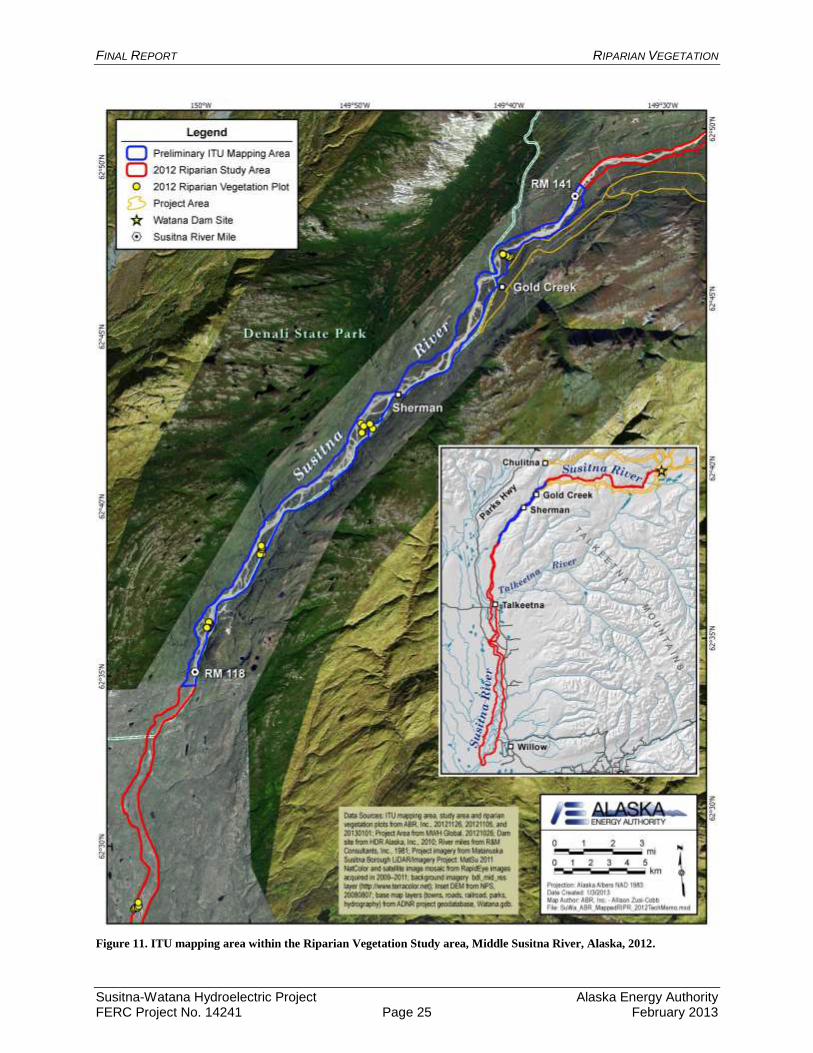
limited to a section of the Middle River approximately between RMs 118 and 141 (Figure 11)
that is covered by the Matanuska-Susitna Borough (Mat-Su) aerial imagery collected in mid- to
late summer 2011; this imagery provides the best color signatures for mapping because the
imagery was collected at full vegetation green-up. Color signatures downstream of RM 118 in
areas of the Mat-Su aerial imagery collected earlier (late spring/early summer) are not consistent
with the mid- to late summer imagery because these areas were collected prior to full vegetation
green-up, which makes consistent and accurate interpretation of imagery signatures across the
entire study area difficult. The final preliminary mapping area used in 2012 comprises 2,580 ha
(6,376 acres). It is anticipated that the preliminary ITU mapping (see RSP Section 11.6.4.3 in
AEA 2012b) between RMs 118 and 141, which was initiated in 2012, will be completed in 1Q
2013.
The preliminary ITU mapping was conducted on-screen in ArcGIS using a minimum mapping
size of 1 acre for terrestrial map polygons and 0.25 acre for water bodies. ITU map polygons
were attributed with geomorphology (e.g., Braided Active Overbank Deposit); surface form
(e.g., Mid-channel Bar); vegetation class (e.g., Open Balsam Poplar Forest), and poplar size class
(e.g., pole, timber, large timber). Riparian vegetation was mapped to the Level IV of the AVC
(Viereck et al. 1992) with adjustments, as needed, for early successional riparian stages
following Helm and Collins (1997). Following the mapping, in 2013, the ITU codes will be
aggregated into a set of preliminary riparian ecotypes based on the combination of ITUs that best
represents the local-scale riparian habitats in the mapping area.
6. DISCUSSION
The collection of riparian vegetation field data and the preliminary ITU mapping efforts in 2012
represent the first year of work in a multi-year study of riparian vegetation for the Project. The
data from 2012 will be combined with those collected in 2013 and 2014 to prepare complete
vegetation, wildlife habitat, and wetland maps for riparian areas downstream of the proposed
dam site. The data collected in 2012 also served as a guide for planning the 2013 and 2014 field
programs for this study, as described in RSP Section 11.6 (AEA 2012b).
As noted above, the final study area boundaries for the Riparian Vegetation Study will be
determined in consultation between AEA and the resource management agencies during 2Q 2013
(i.e., before the 2013 field season) (see RSP Section 11.6 in AEA 2012b).
During the fieldwork in 2012, 19 geomorphic units, 28 vegetation classes, and 15 soil subgroups
were sampled. During the field surveys, physical evidence of ice effects and beaver activity were
commonly observed in the Susitna River floodplain. Field surveys will continue in 2013 and
2014 to collect additional ground-reference data to support ITU mapping throughout the study
area, and to support the modeling of natural vegetation succession pathways for riparian areas
along the Susitna River (see RSP Section 11.6 in AEA 2012b).
To date, the relocation of some of the historic vegetation plots surveyed in the 1980s and 1990s
was not successful. Nine plots appeared to be presently located in active river channels as the
result of either natural changes in the floodplain and channel configuration through time, or
spatial errors associated with the conversion of the location coordinates from original aerial
images. At five other plots, the wooden marker stakes could not be relocated.

FINAL REPORT RIPARIAN VEGETATION
Susitna-Watana Hydroelectric Project Alaska Energy Authority FERC Project No. 14241 Page 8 February 2013
7. REFERENCES
AEA (Alaska Energy Authority). 2011. Pre-Application Document: Susitna–Watana
Hydroelectric Project FERC Project No. 14241. December 2011. Prepared for the Federal
Energy Regulatory Commission, Washington, DC.
AEA. 2012a. Riparian Study Plan: Susitna-Watana Hydroelectric Project FERC Project No.
14241. May 2012. Prepared by the Alaska Energy Authority, Anchorage, Alaska.AEA.
2012b. Revised Study Plan: Susitna-Watana Hydroelectric Project FERC Project No.
14241. December 2012. Prepared for the Federal Energy Regulatory Commission by the
Alaska Energy Authority, Anchorage, Alaska.
Austin, M. P., and P. C. Heyligers. 1989. Vegetation survey design for conservation: Gradsect
sampling of forests in northeastern New South Wales. Biological Conservation 50: 13–
32.
Helm, D. J., and W. B. Collins. 1997. Vegetation succession and disturbance on a boreal forest
floodplain, Susitna River, Alaska. Canadian Field-Naturalist 111:553–566.
Hultén, E. 1968. Flora of Alaska and neighboring territories. Stanford University Press,
Stanford, CA. 1,008 pp.
Jorgenson, M.T., J.E. Roth, M. Emers, S.F. Schlentner, D.K. Swanson, E.R. Pullman, J.S.
Mitchell, and A.S. Stickney. 2003. An ecological land survey in the Northeast Planning
Area of the National Petroleum Reserve–Alaska, 2002. Report for ConocoPhillips
Alaska, Inc., Anchorage, AK and Anadarko Petroleum Corp, Anchorage AK, by ABR,
Inc., Fairbanks, AK. 128 pp.
Jorgenson, M.J., J.E. Roth, P.F. Miller, M.J. Macander, M.S. Duffy, A.F. Wells, G.V. Frost, and
E.R. Pullman. 2009. An ecological land survey and landcover map of the Arctic Network.
Natural Resource Report NPS/ARCN/NRTR—2009/270. National Park Service, Fort
Collins, Colorado. 307 pp.
McKendrick, J. D., W. Collins, D. Helm, J. McMullen, and J. Koranda. 1982. Susitna
Hydroelectric Project environmental studies, Phase I final report, Subtask 7.12—Plant
ecology studies. Report prepared by University of Alaska, Agricultural Experiment
Station, Palmer, for Alaska Power Authority, Anchorage. 124 pp. + appendix. [APA Doc.
No. 1321].
R2 Resource Consultants, Inc., GW Scientific, Brailey Hydrologic, and Geovera. Open Water
HEC-RAS Flow Routing Model. Prepared for the Alaska Energy Authority, Anchorage,
Alaska.
Schoeneberger, P.J., Wysocki, D.A., Benham, E.C., and Broderson, W.D. (editors), 2002. Field
book for describing and sampling soils, Version 2.0. Natural Resources Conservation
Service, National Soil Survey Center, Lincoln, NE.
Soil Survey Division Staff. 1993. Soil survey manual. Soil Conservation Service. U.S.
Department of Agriculture Handbook 18.
Soil Survey Staff. 2010. Keys to Soil Taxonomy. 11th ed. USDA-Natural Resources
Conservation Service, Washington, D.C.

FINAL REPORT RIPARIAN VEGETATION
Susitna-Watana Hydroelectric Project Alaska Energy Authority FERC Project No. 14241 Page 9 February 2013
USDA NRCS (U.S. Department of Agriculture, Natural Resources Conservation Service). 2012.
The PLANTS Database. National Plant Data Team, Greensboro, NC 27401-4901 USA.
Available online at http://plants.usda.gov (accessed 17 June 2012).
Viereck, L. A., C. T. Dyrness, A. R. Batten, and K. J. Wenzlick. 1992. The Alaska Vegetation
Classification. Pacific Northwest Research Station, U.S. Forest Service, Portland, OR.
Gen. Tech. Rep. PNW-GTR-286. 278 pp.
Viereck, L. A., and E. L. Little. 2007. Alaska Trees and Shrubs, 2nd
Edition. University of Alaska
Press, Fairbanks, AK. 359 pp.

FINAL REPORT RIPARIAN VEGETATION
Susitna-Watana Hydroelectric Project Alaska Energy Authority FERC Project No. 14241 Page 10 February 2013
8. TABLES

FINAL REPORT RIPARIAN VEGETATION
Susitna-Watana Hydroelectric Project Alaska Energy Authority FERC Project No. 14241 Page 11 February 2013
Table 1. Descriptions of common geomorphic units sampled in the Riparian Vegetation Study area, Susitna River
floodplain, Alaska, 2012.
Geomorphic Unit Description
Braided Active Overbank Deposit Vertical accretion deposits on low portions of the overbank environment in close proximity to the braided river channels. The deposits are comprised of silts and fine sands that have a laminar, interbedded structure formed by changes in velocity and deposition during waxing and waning floods. Frequent flooding and sedimentation prevents organic matter accumulation. Fine-grained material must be >40 cm (16 in) thick and organic layers comprise less than 10% of the thickness.
Braided Coarse Active Channel Deposit Lateral accretion deposits formed in regularly flooded braided channels where flow is separated by mid-channel islands. Riverbed material can range from gravelly to cobbly sands, while lateral accretion deposits along point bars typically are less rocky and sandier.
Braided Inactive Overbank Deposit Vertical accretion deposits formed on higher portions of the overbank environment in close proximity to braided river channels. Areas are subject to infrequent flooding (approximately every 5–25 years). Comprised of interbedded organics, silts and fine sands. Deposit is >40 cm (16 in) thick and organic layers comprise 10–90% of the top 40 cm (16 in).
Meander Active Overbank Deposit Similar to braided active overbank deposits but it occurs along meandering or anastomosing river channels.
Meander Inactive Overbank Deposit Similar to braided inactive overbank deposits but it occurs along meandering or anastomosing river channels.

FINAL REPORT RIPARIAN VEGETATION
Susitna-Watana Hydroelectric Project Alaska Energy Authority FERC Project No. 14241 Page 12 February 2013
Table 2. Descriptions of common Viereck et al. (1992) Level IV vegetation classes sampled in the Riparian Vegetation
Study area, Susitna River floodplain, Alaska, 2012.
Vegetation Class Description
Closed Balsam Poplar Forest Closed (>60% tree cover) riverine forests dominated by Populus balsamifera. Commonly associated species include Viburnum edule, Rosa acicularis, Alnus crispa, Alnus tenuifolia, Artemisia tilesii, and Aster sibiricus.
Open Balsam Poplar Forest Open (25–60% tree cover) riverine forests dominated by Populus balsamifera. Commonly associated species include Alnus tenuifolia, Viburnum edule, Mertensia paniculata, Equisetum arvense, and Calamagrostis canadensis.
Open Spruce–Paper Birch Forest
Upland, lowland, or riverine forests with an open (25–60% cover) canopy co-dominated by Betula papyrifera and Picea glauca. Commonly associated species include Viburnum edule, Rosa acicularis, Ribes triste, Streptopus amplexifolius, Dryopteris dilatata americana, Trientalis europaea arctica, Epilobium angustifolium, and Lycopodium annotinum.
Open Tall Alder Shrub Riverine and lowland stands of open (25–75% shrub cover) tall shrub (>1.5 m [4.9 ft] tall) dominated or co-dominated by Alnus sinuata, A. tenuifolia, and/or A. crispa (riverine). Commonly associated species include Salix alaxensis, Artemisia tilesii, Populus balsamifera, Salix barclayi, and Calamagrostis canadensis.
Partially Vegetated Sites where vegetation is poorly established and total live cover is 5–30%. Commonly associated species include Salix alaxensis, Populus balsamifera, Artemisia tilesii, Equisetum variegatum, Astragalus alpinus, Epilobium latifolium, and Dryas drummondii.
Large Umbel Meadow Forb-dominated meadows in which Heracleum lanatum is the dominate forb. Commonly associated species include Polemonium acutiflorum, Mertensia paniculata, Calamagrostis canadensis, Thalictrum sparsiflorum, Epilobium angustifolium, and Botrychium lunaria.

FINAL REPORT RIPARIAN VEGETATION
Susitna-Watana Hydroelectric Project Alaska Energy Authority FERC Project No. 14241 Page 13 February 2013
Table 3. Descriptions of common soil subgroups sampled in the Riparian Vegetation Study area, Susitna River floodplain,
Alaska, 2012.
Table arranged hierarchically (from least specific to most specific) beginning with soil order (e.g., Entisols), suborder (e.g., Fluvents), great group (e.g., Cryofluvents), and subgroup (e.g., Aquic Cryofluvents).
Soil subgroup Description
Entisols Soils that are weakly developed and lack any subsurface diagnostic horizons. If a surface horizon enriched with humus (A horizon) has developed, it is typically thin and overlies a soil solum with little to no illuvial pedogenesis.
Fluvents Entisols that have buried soil horizon(s) with an appreciation of organic carbon typically resulting from flooding events.
Cryofluvents Fluvents that have formed in a cryic soil temperature regime. Soils in the cryic temperature regime have a mean annual soil temperature at 50 cm (20 in) below the soil surface between 0 and 8°C but do not have permafrost.
Aquic Cryofluvents Cryofluvents that have within 50 cm (20 in) of the soil surface redoximorphic features resulting from saturated anaerobic soil conditions.
Oxyaquic Cryofluvents Cryofluvents that do not remain saturated, but experience periods of saturation within 100 cm (39 in) of the mineral soil surface in normal years for 20 or more consecutive days, or 30 or more cumulative days.
Typic Cryofluvents Cryofluvents that are typical for this great group.
Orthents Entisols that do not meet the taxonomic requirements for any other suborder of Entisols. These soils are either young deposits, or typically occur in areas either prone to erosion on naturally unstable landscape positions or sometimes due to intensive land use management practices.
Cryorthents Orthents that occur in a cryic soil temperature regime. Soils in the cryic temperature regime have a mean annual soil temperature at 50 cm (20 in) below the soil surface between 0 and 8° C but do not have permafrost.
Oxyaquic Cryorthents Cryorthents that that do not remain saturated, but experience periods of saturation within 100 cm of the mineral soil surface in normal years for 20 or more consecutive days, or 30 or more cumulative days.
Typic Cryorthents Cryorthents that are typical for this great group.

FINAL REPORT RIPARIAN VEGETATION
Susitna-Watana Hydroelectric Project Alaska Energy Authority FERC Project No. 14241 Page 14 February 2013
9. FIGURES

FINAL REPORT RIPARIAN VEGETATION
Susitna-Watana Hydroelectric Project Alaska Energy Authority FERC Project No. 14241 Page 15 February 2013
Figure 1. Study area and locations of completed 2012 field study plots for the Riparian Vegetation Study, Susitna-
Watana Hydroelectric Project, Alaska.

FINAL REPORT RIPARIAN VEGETATION
Susitna-Watana Hydroelectric Project Alaska Energy Authority FERC Project No. 14241 Page 16 February 2013
Figure 2. Open Balsam Poplar Forest showing the sapling (left) and timber (right) successional stages, Riparian
Vegetation Study area, Susitna River floodplain, Alaska, 2012.
.

FINAL REPORT RIPARIAN VEGETATION
Susitna-Watana Hydroelectric Project Alaska Energy Authority FERC Project No. 14241 Page 17 February 2013
Figure 3. Open Spruce–Paper Birch forest, Riparian Vegetation Study area, Susitna River floodplain, Alaska, 2012.

FINAL REPORT RIPARIAN VEGETATION
Susitna-Watana Hydroelectric Project Alaska Energy Authority FERC Project No. 14241 Page 18 February 2013
Figure 4. Large Umbel Meadow, Riparian Vegetation Study area, Susitna River floodplain, Alaska, 2012. Vegetation in
photo is approximately 1.5–2.0 meters (4.9–6.6 feet) tall.

FINAL REPORT RIPARIAN VEGETATION
Susitna-Watana Hydroelectric Project Alaska Energy Authority FERC Project No. 14241 Page 19 February 2013
Figure 5. Typic Cryofluvents at a river bank exposure, Riparian Vegetation Study area, Susitna River floodplain, Alaska,
2012.
Dark horizontal lines (red arrows) indicate layers of organic material buried by periodic past sedimentation events. Orange and
grayish layers (blue arrows) are riverine sands and silts. Cobbly/gravelly layer (between orange lines) indicates historic large,
powerful flood event. The cobbly layer at the bottom of the pit represents the original cobble bar surface (below green line).
Shovel in photo is approximately 1 meter (3.3 feet) tall.

FINAL REPORT RIPARIAN VEGETATION
Susitna-Watana Hydroelectric Project Alaska Energy Authority FERC Project No. 14241 Page 20 February 2013
Figure 6. Oxyaquic Cryorthents on an active cobble bar showing water table at 35 centimeter (14 inches) below soil
surface, Riparian Vegetation Study area, Susitna River floodplain, Alaska, 2012.

FINAL REPORT RIPARIAN VEGETATION
Susitna-Watana Hydroelectric Project Alaska Energy Authority FERC Project No. 14241 Page 21 February 2013
Figure 7. Ice scar on balsam poplar, Riparian Vegetation Study area, Susitna River floodplain, Alaska. Scientist in photo
is ~1.9 meter (6.2 feet) tall.

FINAL REPORT RIPARIAN VEGETATION
Susitna-Watana Hydroelectric Project Alaska Energy Authority FERC Project No. 14241 Page 22 February 2013
Figure 8. Recent ice gouging and ice bull-dozing on a mid-river gravel bar, Riparian Vegetation Study area, Susitna
River, Alaska, 2012.
Ice gouge
Ice bull-dozed
mounds

FINAL REPORT RIPARIAN VEGETATION
Susitna-Watana Hydroelectric Project Alaska Energy Authority FERC Project No. 14241 Page 23 February 2013
Figure 9. Aerial view of beaver pond complex, Riparian Vegetation Study area, Susitna River floodplain, Alaska, 2012.
Beaver dams

FINAL REPORT RIPARIAN VEGETATION
Susitna-Watana Hydroelectric Project Alaska Energy Authority FERC Project No. 14241 Page 24 February 2013
Figure 10. Beaver impoundment showing older, vegetated dam with breach recently maintained by beavers, Riparian
Vegetation Study area, Susitna River floodplain, Alaska, 2012.
Breach in dam recently
patched by beavers
Older, vegetated dam
FINAL REPORT RIPARIAN VEGETATION
Susitna-Watana Hydroelectric Project Alaska Energy Authority FERC Project No. 14241 Page 25 February 2013
Figure 11. ITU mapping area within the Riparian Vegetation Study area, Middle Susitna River, Alaska, 2012.