
ATTACHMENT B-1 Pre-Design Investigation Logs - … Landfill 2/Attachment B...ATTACHMENT B-1...
38
ATTACHMENT B-1 Pre-Design Investigation Logs (for locations that were re-sampled in April 2016)
Transcript of ATTACHMENT B-1 Pre-Design Investigation Logs - … Landfill 2/Attachment B...ATTACHMENT B-1...

ATTACHMENT B-1 Pre-Design Investigation Logs(for locations that were re-sampled in April 2016)

FILLFILL
FILL
FILL
FILL
FILL
FILL
(0'-0.3') Dry, brown, SILT, little fine sand, organics (ML)(0.3'-2.2') Dry, brown, SILT, little fine sand, trace fine gravel, trace clay(ML)
(2.2'-4.4') Moist, brown, medium to fine SAND, some coarse to fine gravel,trace silt (SP)
(4.4'-5') Moist, dark brown, medium to fine SAND, little silt, trace clay (SM)
(5'-6') Wet, brown, medium to fine SAND, trace silt (SM)
(6'-8') Wet, black, medium to fine granular material with metallic sheen,very fine black silt
(8'-10') Wet, gray, SILT, some coarse to fine gravelObserved wet, gray, coarse to medium sand lense (ML) at 9.0 ft bgs
0.0
0.0
GP
GP
60/46
60/43
S-1
S-2
0.019
0.006
Drillers: John Chase, Bobby Orsini
Drilling Date: Start: 6/23/2015 End: 6/23/2015
Borehole Coordinates:
N 392,374.82 E 900,716.13
Surface Elevation (ft.): 76.2
Total Depth (ft.): 20Drilling Method/Rig: Direct Push/Geoprobe 7822DT
Drilling Contractor: Geosearch, Inc.
Abandonment Method: Bentonite Chips
Field Screening Instrument: PID and Jerome meters
Logged By: G. Barr, J. Kocis
DRILLING METHODS:HSASSAHAARDTRFRMRRCCTJETDDTC
Hollow Stem AugerSolid Stem AugerHand AugerAir RotaryDual Tube RotaryFoam RotaryMud RotaryReverse CirculationCable ToolJettingDrivingDrill Through Casing
OTHER:AGS -
ASCSBXNXGPHPSSSTWS
------------
SAMPLING TYPES:
Above GroundSurface
Auger/Grab SampleCalifornia Sampler1.5" Rock Core2.1" Rock CoreGeoprobeHydro PunchSplit SpoonShelby TubeWash Sample
---------
REMARKS
Reviewed by: G. Barr Date: 11/02/2015
EXPLANATION OF ABBREVIATIONS
Elev.Depth
(ft.)
MaterialDescription
Sam
ple
Rec
over
y(I
nche
s)
SampleNumber
Sam
ple
Typ
e
PID
Rea
ding
(ppm
v)
Jero
me
Hg
Rea
ding
(m
g/m
3)
Gra
phic
Log
Str
atum
Des
igna
tion
76.2
71.2
66.2
0
5
SB-LF2-15
B O R E H O L E L O GSheet 1 of 2
Client: Mallinckrodt US LLC
Project Location: Orrington, Maine
Project Name: Orrington Remediation Site
Project Number: BR0292
GE
OS
YN
TE
C B
L_N
O B
LOW
S P
ID/J
ER
OM
E O
RR
ING
TO
N T
EM
PLA
TE
.GP
J C
DM
_MA
.GD
T 1
1/2
4/15

FILL
ML
ML
GM
(10'-13') Wet, gray-black, medium to fine granular material and very finesilt
(13'-15') Moist, light brown, SILT, little medium to fine gravel, trace finesand (TILL)
(15'-17') Moist, light brown SILT, little medium to fine gravel, trace finesand (TILL)
(17'-20') Moist, gray, coarse to medium GRAVEL, little silt, trace fine sand(TILL)
End of exploration at 20 ft bgs
0.0
0.0
GP
GP
60/44
60/48
S-3
S-4
0.000
0.000
Elev.Depth
(ft.)
MaterialDescription
Sam
ple
Rec
over
y(I
nche
s)SampleNumber
Sam
ple
Typ
e
PID
Rea
ding
(ppm
v)
Jero
me
Hg
Rea
ding
(m
g/m
3)
Gra
phic
Log
Str
atum
Des
igna
tion
66.2
61.2
56.2
51.2
10
15
20
25
SB-LF2-15
B O R E H O L E L O GSheet 2 of 2
Client: Mallinckrodt US LLC
Project Location: Orrington, Maine
Project Name: Orrington Remediation Site
Project Number: BR0292
GE
OS
YN
TE
C B
L_N
O B
LOW
S P
ID/J
ER
OM
E O
RR
ING
TO
N T
EM
PLA
TE
.GP
J C
DM
_MA
.GD
T 1
1/2
4/15

(0'-15') See SB-LF2-15 boring log for lithologic description.
Drillers: John Chase, Bobby Orsini
Drilling Date: Start: 06/26/2015 End: 06/26/2015
Borehole Coordinates:
N 392,374.82 E 900,716.13
Surface Elevation (ft.): 76.2
Total Depth (ft.): 20Drilling Method/Rig: Direct Push/Geoprobe 7822DT
Drilling Contractor: Geosearch, Inc.
Abandonment Method: Bentonite Chips
Field Screening Instrument: PID and Jerome meters
Logged By: G. Barr, J. Kocis
DRILLING METHODS:HSASSAHAARDTRFRMRRCCTJETDDTC
Hollow Stem AugerSolid Stem AugerHand AugerAir RotaryDual Tube RotaryFoam RotaryMud RotaryReverse CirculationCable ToolJettingDrivingDrill Through Casing
OTHER:AGS -
ASCSBXNXGPHPSSSTWS
------------
SAMPLING TYPES:
Above GroundSurface
Re-sample at 15-20 ft bgs due to potential smearing of shallowermaterial on original samples. Offset ~1.5 East of original location.Soil boring SB-LF2-15A was not performed.
Auger/Grab SampleCalifornia Sampler1.5" Rock Core2.1" Rock CoreGeoprobeHydro PunchSplit SpoonShelby TubeWash Sample
---------
REMARKS
Reviewed by: Date:
EXPLANATION OF ABBREVIATIONS
Elev.Depth(ft.)
MaterialDescription
Sam
ple
Rec
over
y(I
nche
s)
SampleNumber
Sam
ple
Typ
e
PID
Rea
ding
(ppm
v)
Jero
me
Hg
Rea
ding
(m
g/m
3)
Gra
phic
Log
Str
atum
Des
igna
tion
76.2
71.2
66.2
0
5
SB-LF2-15B
B O R E H O L E L O GSheet 1 of 2
Client: Mallinckrodt US LLC
Project Location: Orrington, Maine
Project Name: Orrington Remediation Site
Project Number: BR0292
GE
OS
YN
TE
C B
L_N
O B
LOW
S P
ID/J
ER
OM
E O
RR
ING
TO
N T
EM
PLA
TE
.GP
J C
DM
_MA
.GD
T 6
/6/1
6

ML (15'-20') Moist, light brown, SILT and coarse to fine gravel, trace fine sand
End of Boring at 20 ft bgs
0.0 0.000GP S-1 60/36
Elev.Depth(ft.)
MaterialDescription
Sam
ple
Rec
over
y(I
nche
s)SampleNumber
Sam
ple
Typ
e
PID
Rea
ding
(ppm
v)
Jero
me
Hg
Rea
ding
(m
g/m
3)
Gra
phic
Log
Str
atum
Des
igna
tion
66.2
61.2
56.2
51.2
10
15
20
25
SB-LF2-15B
B O R E H O L E L O GSheet 2 of 2
Client: Mallinckrodt US LLC
Project Location: Orrington, Maine
Project Name: Orrington Remediation Site
Project Number: BR0292
GE
OS
YN
TE
C B
L_N
O B
LOW
S P
ID/J
ER
OM
E O
RR
ING
TO
N T
EM
PLA
TE
.GP
J C
DM
_MA
.GD
T 6
/6/1
6

FILL
(0-5') See SB-LF5-15 boring log for lithologic description.
(5-6') Moist, dark brown-dark gray-black, coarse-fine SAND, little silt. (SW)
End of Exploration at 6' BGS.
0.0GP 12/11S-1 0.000
Drillers: J. Emma, M. Rash
Drilling Date: Start: 7/20/2015 End: 7/20/2015
Borehole Coordinates:
N 392,374.82 E 900,716.13
Surface Elevation (ft.): 76.19
Total Depth (ft.): 6Drilling Method/Rig: DPT/Geoprobe 6620DT
Drilling Contractor: Geosearch, Inc.
Abandonment Method: Backfilled with bentonite chips
Field Screening Instrument: PID, Jerome MVA
Logged By: P. Donohue
DRILLING METHODS:HSASSAHAARDTRFRMRRCCTJETDDTC
Hollow Stem AugerSolid Stem AugerHand AugerAir RotaryDual Tube RotaryFoam RotaryMud RotaryReverse CirculationCable ToolJettingDrivingDrill Through Casing
OTHER:AGS -
ASCSBXNXGPHPSSSTWS
------------
SAMPLING TYPES:
Above GroundSurface
Sampled discretely from 5-6' BGS for Hg speciation. The JeromeMVA readings indicated represent the highest recorded values inthat range.Offset of SB-LF1-15, 1' north of original boring location.
Auger/Grab SampleCalifornia Sampler1.5" Rock Core2.1" Rock CoreGeoprobeHydro PunchSplit SpoonShelby TubeWash Sample
---------
REMARKS
Reviewed by: E. Ashley Date: 10/23/2015
EXPLANATION OF ABBREVIATIONS
Elev.Depth
(ft.)
MaterialDescription
Sam
ple
Rec
over
y(I
nche
s)
SampleNumber
Sam
ple
Typ
e
PID
Rea
ding
(ppm
v)
Jero
me
Hg
Rea
ding
(m
g/m
3)
Gra
phic
Log
Str
atum
Des
igna
tion
76.2
71.2
66.2
0
5
SB-LF2-15C
B O R E H O L E L O GSheet 1 of 1
Client: Mallinckrodt US LLC
Project Location: Orrington, Maine
Project Name: Orrington Remediation Site
Project Number: 5000-110260
GE
OS
YN
TE
C B
L_N
O B
LOW
S P
ID/J
ER
OM
E L
F2.
GP
J C
DM
_MA
.GD
T 1
0/19
/15

FILL
FILL
FILL
FILL
FILL
(0'-1') Moist, brown, medium to fine SAND, some silt little medium to finegravel (SW-SM)
(1'-4.6') Moist, brown-gray, medium to fine SAND, trace silt (SW)
(4.6'-5') Moist, black, graphite-like material
(5'-7.2') Wet, brown, SILT, some fine sand, little wood debris (ML)
(7.2'-10') Moist, gray, coarse to fine GRAVEL, some silt, little fine sand(GM)
0.0
0.0
GP
GP
60/44
60/30
S-1
S-2
0.000
0.000
Drillers: John Chase, Bobby Orsini
Drilling Date: Start: 06/24/2015 End: 06/24/2015
Borehole Coordinates:
N 392,384.94 E 900,783.28
Surface Elevation (ft.): 77.4
Total Depth (ft.): 19Drilling Method/Rig: Direct Push/Geoprobe 7822DT
Drilling Contractor: Geosearch, Inc.
Abandonment Method: Bentonite Chips
Field Screening Instrument: PID and Jerome meters
Logged By: G. Barr, J. Kocis
DRILLING METHODS:HSASSAHAARDTRFRMRRCCTJETDDTC
Hollow Stem AugerSolid Stem AugerHand AugerAir RotaryDual Tube RotaryFoam RotaryMud RotaryReverse CirculationCable ToolJettingDrivingDrill Through Casing
OTHER:AGS -
ASCSBXNXGPHPSSSTWS
------------
SAMPLING TYPES:
Above GroundSurface
VOCs and chloropicrin collected at 1-2 ft and 2-3 ftAuger/Grab SampleCalifornia Sampler1.5" Rock Core2.1" Rock CoreGeoprobeHydro PunchSplit SpoonShelby TubeWash Sample
---------
REMARKS
Reviewed by: G. Barr Date: 11/02/2015
EXPLANATION OF ABBREVIATIONS
Elev.Depth
(ft.)
MaterialDescription
Sam
ple
Rec
over
y(I
nche
s)
SampleNumber
Sam
ple
Typ
e
PID
Rea
ding
(ppm
v)
Jero
me
Hg
Rea
ding
(m
g/m
3)
Gra
phic
Log
Str
atum
Des
igna
tion
77.4
72.4
67.4
0
5
SB-LF2-23
B O R E H O L E L O GSheet 1 of 2
Client: Mallinckrodt US LLC
Project Location: Orrington, Maine
Project Name: Orrington Remediation Site
Project Number: BR0292
GE
OS
YN
TE
C B
L_N
O B
LOW
S P
ID/J
ER
OM
E O
RR
ING
TO
N T
EM
PLA
TE
.GP
J C
DM
_MA
.GD
T 1
1/2
4/15

FILL
ML
ML
GM
(10'-12') Moist, gray-brown, SILT and medium to fine SAND, little mediumto fine gravel, trace clay (ML/GM)
(12'-15') Moist, brown, SILT, some fine sand, little medium to fine gravel(TILL)Observed medium sand lense (SP) at 13.6-13.7 ft bgs
(15'-17') Moist, brown, SILT, some fine sand, little medium to fine gravel(TILL)
(17'-19') Moist, gray, coarse to fine GRAVEL, some fine sand, trace silt(TILL)
End of exploration at 20 ft bgs.
0.0
0.0
GP
GP
60/42
60/44
S-3
S-4
0.000
0.000
Elev.Depth
(ft.)
MaterialDescription
Sam
ple
Rec
over
y(I
nche
s)SampleNumber
Sam
ple
Typ
e
PID
Rea
ding
(ppm
v)
Jero
me
Hg
Rea
ding
(m
g/m
3)
Gra
phic
Log
Str
atum
Des
igna
tion
67.4
62.4
57.4
52.4
10
15
20
25
SB-LF2-23
B O R E H O L E L O GSheet 2 of 2
Client: Mallinckrodt US LLC
Project Location: Orrington, Maine
Project Name: Orrington Remediation Site
Project Number: BR0292
GE
OS
YN
TE
C B
L_N
O B
LOW
S P
ID/J
ER
OM
E O
RR
ING
TO
N T
EM
PLA
TE
.GP
J C
DM
_MA
.GD
T 1
1/2
4/15

FILL
(0-2') See SB-LF2-23 boring log for lithologic descriptions.
(2-3') Dry, brown, coarse-fine SAND, trace medium-fine rounded gravel,trace silt. (SW)
End of Exploration/advancement at 3' BGS.
0.0GP 12/12S-1 0.000
Drillers: J. Emma, M. Rash
Drilling Date: Start: 7/20/2015 End: 7/20/2015
Borehole Coordinates:
N 392,384.94 E 900,783.28
Surface Elevation (ft.): 77.36
Total Depth (ft.): 3Drilling Method/Rig: DPT/Geoprobe 6620DT
Drilling Contractor: Geosearch, Inc.
Abandonment Method: Backfilled with bentonite chips
Field Screening Instrument: PID, Jerome MVA
Logged By: P. Donohue
DRILLING METHODS:HSASSAHAARDTRFRMRRCCTJETDDTC
Hollow Stem AugerSolid Stem AugerHand AugerAir RotaryDual Tube RotaryFoam RotaryMud RotaryReverse CirculationCable ToolJettingDrivingDrill Through Casing
OTHER:AGS -
ASCSBXNXGPHPSSSTWS
------------
SAMPLING TYPES:
Above GroundSurface
Sampled discretely from 2-3' BGS for Hg speciation. Offset ofSB-LF2-23, 1' west of original boring location. The Jerome MVAreadings indicated represent the highest recorded values in thatrange.
Auger/Grab SampleCalifornia Sampler1.5" Rock Core2.1" Rock CoreGeoprobeHydro PunchSplit SpoonShelby TubeWash Sample
---------
REMARKS
Reviewed by: E. Ashley Date: 10/23/2015
EXPLANATION OF ABBREVIATIONS
Elev.Depth
(ft.)
MaterialDescription
Sam
ple
Rec
over
y(I
nche
s)
SampleNumber
Sam
ple
Typ
e
PID
Rea
ding
(ppm
v)
Jero
me
Hg
Rea
ding
(m
g/m
3)
Gra
phic
Log
Str
atum
Des
igna
tion
77.4
72.4
67.4
0
5
SB-LF2-23B
B O R E H O L E L O GSheet 1 of 1
Client: Mallinckrodt US LLC
Project Location: Orrington, Maine
Project Name: Orrington Remediation Site
Project Number: 5000-110260
GE
OS
YN
TE
C B
L_N
O B
LOW
S P
ID/J
ER
OM
E L
F2.
GP
J C
DM
_MA
.GD
T 1
0/19
/15

FILL
FILL
FILL
FILL
FILL
FILLFILL
(0'-0.4') Top Soil
(0.4'-2') Dry, red brown-brown, fine SAND, some silt (SM)
(2'-4.6') Dry, light brown, SAND with gravel and silt, trace clay (SM)
(4.6'-5') Moist, gray, medium to fine SAND, some clay, trace gravel (SC)
(5'-8.3') Moist, gray, medium to fine SAND, some clay, some gravel (SC)
(8.3'-8.5') Moist, dark gray, SILT, wood debris (ML)(8.5'-10') Moist, red brown, SILT, wood debris (ML)
0.0
0.0
GP
GP
60/44
60/42
S-1
S-2
0.000
0.000
Drillers: John Chase, Eric Woodward
Drilling Date: Start: 06/16/2015 End: 06/16/2015
Borehole Coordinates:
N 392,470.45 E 900,808.17
Surface Elevation (ft.): 73.4
Total Depth (ft.): 18Drilling Method/Rig: Direct Push/Geoprobe 7822DT
Drilling Contractor: Geosearch, Inc.
Abandonment Method: Bentonite Chips
Field Screening Instrument: PID and Jerome meters
Logged By: G. Barr, J. Kocis
DRILLING METHODS:HSASSAHAARDTRFRMRRCCTJETDDTC
Hollow Stem AugerSolid Stem AugerHand AugerAir RotaryDual Tube RotaryFoam RotaryMud RotaryReverse CirculationCable ToolJettingDrivingDrill Through Casing
OTHER:AGS -
ASCSBXNXGPHPSSSTWS
------------
SAMPLING TYPES:
Above GroundSurface
Auger/Grab SampleCalifornia Sampler1.5" Rock Core2.1" Rock CoreGeoprobeHydro PunchSplit SpoonShelby TubeWash Sample
---------
REMARKS
Reviewed by: G. Barr Date: 11/02/2015
EXPLANATION OF ABBREVIATIONS
Elev.Depth
(ft.)
MaterialDescription
Sam
ple
Rec
over
y(I
nche
s)
SampleNumber
Sam
ple
Typ
e
PID
Rea
ding
(ppm
v)
Jero
me
Hg
Rea
ding
(m
g/m
3)
Gra
phic
Log
Str
atum
Des
igna
tion
73.4
68.4
63.4
0
5
SB-LF2-24
B O R E H O L E L O GSheet 1 of 2
Client: Mallinckrodt US LLC
Project Location: Orrington, Maine
Project Name: Orrington Remediation Site
Project Number: BR0292
GE
OS
YN
TE
C B
L_N
O B
LOW
S P
ID/J
ER
OM
E O
RR
ING
TO
N T
EM
PLA
TE
.GP
J C
DM
_MA
.GD
T 1
1/2
4/15

FILL
FILL
FILL
FILL
GW
GW
SW
(10'-11') Moist, dark brown, SILT, trace organics (OL)
(11'-13') Moist, dark brown, SILT, trace organics (OL)
(13'-13.5') Moist, gray, CLAY (CL)
(13.5'-14') Moist, gray, CLAY, some silt, some gravel, little fine sand (CL)
(14'-15') Moist, light gray-brown, GRAVEL, some coarse to fine sand,some silt (TILL)
(15'-16') Moist, light gray-brown, GRAVEL, some coarse to fine sand,some silt (TILL)
(16'-18') Moist, light gray, medium to fine SAND (TILL)
End of exploration at 20 ft bgs.
0.0
0.0
GP
GP
60/42
60/30
S-3
S-4
0.000
0.000
Elev.Depth
(ft.)
MaterialDescription
Sam
ple
Rec
over
y(I
nche
s)SampleNumber
Sam
ple
Typ
e
PID
Rea
ding
(ppm
v)
Jero
me
Hg
Rea
ding
(m
g/m
3)
Gra
phic
Log
Str
atum
Des
igna
tion
63.4
58.4
53.4
48.4
10
15
20
25
SB-LF2-24
B O R E H O L E L O GSheet 2 of 2
Client: Mallinckrodt US LLC
Project Location: Orrington, Maine
Project Name: Orrington Remediation Site
Project Number: BR0292
GE
OS
YN
TE
C B
L_N
O B
LOW
S P
ID/J
ER
OM
E O
RR
ING
TO
N T
EM
PLA
TE
.GP
J C
DM
_MA
.GD
T 1
1/2
4/15

FILL
(0-2') See SB-LF2-24 boring logs for lithologic descriptions.
(2-3') Moist, brown, SILT, some fine sand, little coarse-fine sub-angularand angular gravel, trace clay. (ML)
End of Exploration at 3' BGS.
0.0GP 12/12S-1 0.000
Drillers: J. Emma, M. Rash
Drilling Date: Start: 7/20/2015 End: 7/20/2015
Borehole Coordinates:
N 392,470.45 E 900,808.17
Surface Elevation (ft.): 73.37
Total Depth (ft.): 3Drilling Method/Rig: DPT/Geoprobe 6620DT
Drilling Contractor: Geosearch, Inc.
Abandonment Method: Backfilled with bentonite chips
Field Screening Instrument: PID, Jerome MVA
Logged By: P. Donohue
DRILLING METHODS:HSASSAHAARDTRFRMRRCCTJETDDTC
Hollow Stem AugerSolid Stem AugerHand AugerAir RotaryDual Tube RotaryFoam RotaryMud RotaryReverse CirculationCable ToolJettingDrivingDrill Through Casing
OTHER:AGS -
ASCSBXNXGPHPSSSTWS
------------
SAMPLING TYPES:
Above GroundSurface
Sampled discretely from 2-3' BGS for Hg speciation. Offset ofSB-LF2-24. 1' east of original boring location. The Jerome MVAreadings indicated represent the highest recorded values in thatrange.
Auger/Grab SampleCalifornia Sampler1.5" Rock Core2.1" Rock CoreGeoprobeHydro PunchSplit SpoonShelby TubeWash Sample
---------
REMARKS
Reviewed by: E. Ashley Date: 10/23/2015
EXPLANATION OF ABBREVIATIONS
Elev.Depth
(ft.)
MaterialDescription
Sam
ple
Rec
over
y(I
nche
s)
SampleNumber
Sam
ple
Typ
e
PID
Rea
ding
(ppm
v)
Jero
me
Hg
Rea
ding
(m
g/m
3)
Gra
phic
Log
Str
atum
Des
igna
tion
73.4
68.4
63.4
0
5
SB-LF2-24B
B O R E H O L E L O GSheet 1 of 1
Client: Mallinckrodt US LLC
Project Location: Orrington, Maine
Project Name: Orrington Remediation Site
Project Number: 5000-110260
GE
OS
YN
TE
C B
L_N
O B
LOW
S P
ID/J
ER
OM
E L
F2.
GP
J C
DM
_MA
.GD
T 1
0/19
/15

FILL
FILL
FILL
FILL
FILL
FILL
(0'-1.25') Moist, brown, medium to fine SAND and SILT trace fine gravel,organics (SM)
(1.25'-2.5') Moist, brown, SILT and coarse to fine SAND, little medium tofine gravel (ML)
(2.5'-5') Moist, brown, coarse to fine SAND, trace silt (SW-SM)Observed a tan clay seam at 3.75 ft bgs and black sand material at 5 ftbgs
(5'-6.75') Wet, black, medium to fine graphite-like material
(6.75'-8.75') Wet, gray-brown, medium to fine SAND, trace silt, tracemedium gravel (SP-SM)
(8.75'-10') Wet, brown, SILT, some some coarse to fine sand, trace finegravel, trace organics (ML)Observed an organic seam at 9.75 ft bgs
0.0
0.0
GP
GP
60/41
60/43
S-1
S-2
0.000
0.000
Drillers: John Chase, Bobby Orsini
Drilling Date: Start: 06/22/2015 End: 06/22/2015
Borehole Coordinates:
N 392,419.77 E 900,799.72
Surface Elevation (ft.): 78.4
Total Depth (ft.): 20Drilling Method/Rig: Direct Push/Geoprobe 7822DT
Drilling Contractor: Geosearch, Inc.
Abandonment Method: Bentonite Chips
Field Screening Instrument: PID and Jerome meters
Logged By: J.Gillen, J.Kocis
DRILLING METHODS:HSASSAHAARDTRFRMRRCCTJETDDTC
Hollow Stem AugerSolid Stem AugerHand AugerAir RotaryDual Tube RotaryFoam RotaryMud RotaryReverse CirculationCable ToolJettingDrivingDrill Through Casing
OTHER:AGS -
ASCSBXNXGPHPSSSTWS
------------
SAMPLING TYPES:
Above GroundSurface
Jerome reading for 5-6.75 ft bgs = 0.017 mg/m3Driller notes hole"tightened" at ~12 to 14 ftJerome reading at 11.5 ft bgs= 0.003 mg/m3Native material encountered at 12.5 ftSampling ended at 17 ft
Auger/Grab SampleCalifornia Sampler1.5" Rock Core2.1" Rock CoreGeoprobeHydro PunchSplit SpoonShelby TubeWash Sample
---------
REMARKS
Reviewed by: J. Gillen Date: 11/18/2015
EXPLANATION OF ABBREVIATIONS
Elev.Depth
(ft.)
MaterialDescription
Sam
ple
Rec
over
y(I
nche
s)
SampleNumber
Sam
ple
Typ
e
PID
Rea
ding
(ppm
v)
Jero
me
Hg
Rea
ding
(m
g/m
3)
Gra
phic
Log
Str
atum
Des
igna
tion
78.4
73.4
68.4
0
5
SB-LF2-25
B O R E H O L E L O GSheet 1 of 2
Client: Mallinckrodt US LLC
Project Location: Orrington, Maine
Project Name: Orrington Remediation Site
Project Number: BR0292
GE
OS
YN
TE
C B
L_N
O B
LOW
S P
ID/J
ER
OM
E O
RR
ING
TO
N T
EM
PLA
TE
.GP
J C
DM
_MA
.GD
T 1
1/3
0/15

FILL
ML
ML
ML
(10'-12.5') Wet, gray-blck, coarse to fine SAND, little gravel little silt(SP-SM)
(12.5'-15') Wet, gray-brown, SILT, some coarse to fine sand, tracefractured rock (TILL)
(15'-18') Moist, brown-gray, SILT, some coarse to fine sand, trace mediumto fine gravel, trace fractured rock (TILL)
(18'-20') Moist, brown-gray, SILT, some coarse to fine sand, some mediumto fine gravel, little fractured rock (TILL)
End of exploration at 20 ft bgs.
0.0
0.0
GP
GP
60/47
60/46
S-3
S-4
0.000
0.000
Elev.Depth
(ft.)
MaterialDescription
Sam
ple
Rec
over
y(I
nche
s)SampleNumber
Sam
ple
Typ
e
PID
Rea
ding
(ppm
v)
Jero
me
Hg
Rea
ding
(m
g/m
3)
Gra
phic
Log
Str
atum
Des
igna
tion
68.4
63.4
58.4
53.4
10
15
20
25
SB-LF2-25
B O R E H O L E L O GSheet 2 of 2
Client: Mallinckrodt US LLC
Project Location: Orrington, Maine
Project Name: Orrington Remediation Site
Project Number: BR0292
GE
OS
YN
TE
C B
L_N
O B
LOW
S P
ID/J
ER
OM
E O
RR
ING
TO
N T
EM
PLA
TE
.GP
J C
DM
_MA
.GD
T 1
1/3
0/15

FILL
FILL
FILL
FILL
FILL
FILL
FILL
(0'-2') Dry, light brown, SILT, little gravel, trace fine sand, trace clay (ML)
(2'-3.3') Dry, dark yellowish brown, medium to fine SAND, trace fine gravel(SP)
(3.3'-3.8') Black, medium to fine coarse granular material with metallicsheen(3.8'-5') Moist, yellowish brown-grayish brown fine SAND, trace coarse tofine gravel (SP/SC)Observed a clay layer at 4.0 ft bgs
(5'-6') Moist, grayish brown, coarse to fine SAND and CLAY, some coarseto fine gravel, trace organics (SW/SC)
(6'-7.5') Moist, dark brown, wood debris, little gravel
(7.5'-10') Moist-wet, light gray, fine SAND, some coarse to fine gravel, littlesilt, little clay (SW)
0.0
0.0
GP
GP
60/48
60/36
S-1
S-2
0.000
0.000
Drillers: John Chase, Eric Woodward
Drilling Date: Start: 06/18/2015 End: 06/18/2015
Borehole Coordinates:
N 392,399.30 E 900,806.92
Surface Elevation (ft.): 77.9
Total Depth (ft.): 25Drilling Method/Rig: Direct Push/Geoprobe 7822DT
Drilling Contractor: Geosearch, Inc.
Abandonment Method: Bentonite Chips
Field Screening Instrument: PID and Jerome meters
Logged By: G. Barr, J. Kocis
DRILLING METHODS:HSASSAHAARDTRFRMRRCCTJETDDTC
Hollow Stem AugerSolid Stem AugerHand AugerAir RotaryDual Tube RotaryFoam RotaryMud RotaryReverse CirculationCable ToolJettingDrivingDrill Through Casing
OTHER:AGS -
ASCSBXNXGPHPSSSTWS
------------
SAMPLING TYPES:
Above GroundSurface
Borehole reading 08:53 PID:0.0, Jerome:0.0, 4-gas:0.0,0.0,20.9,0.0~10 ft bgs increase pressure on Geoprobe~19-20 ft bgs, very high pressure increase on Geoprobe
Auger/Grab SampleCalifornia Sampler1.5" Rock Core2.1" Rock CoreGeoprobeHydro PunchSplit SpoonShelby TubeWash Sample
---------
REMARKS
Reviewed by: G. Barr Date: 11/02/2015
EXPLANATION OF ABBREVIATIONS
Elev.Depth
(ft.)
MaterialDescription
Sam
ple
Rec
over
y(I
nche
s)
SampleNumber
Sam
ple
Typ
e
PID
Rea
ding
(ppm
v)
Jero
me
Hg
Rea
ding
(m
g/m
3)
Gra
phic
Log
Str
atum
Des
igna
tion
77.9
72.9
67.9
0
5
SB-LF2-26
B O R E H O L E L O GSheet 1 of 2
Client: Mallinckrodt US LLC
Project Location: Orrington, Maine
Project Name: Orrington Remediation Site
Project Number: BR0292
GE
OS
YN
TE
C B
L_N
O B
LOW
S P
ID/J
ER
OM
E O
RR
ING
TO
N T
EM
PLA
TE
.GP
J C
DM
_MA
.GD
T 1
1/2
4/15

FILL
FILL
FILL
FILL
ML
(10'-11.4') Wet, light gray, fine SAND, some coarse to fine gravel, somesilt, little clay (SW)
(11.4-15) Moist, yellowish brown, SILT, some clay, some coarse to finegravel (ML)
(15'-16') Moist, yellowish brown, SILT, some clay, some coarse to finegravel (ML)
(16'-20') Moist, gray, SILT, some coarse to fine gravel, little clay (ML)
(20'-25') Moist to wet, gray, SILT, some coarse to fine gravel, little mediumto fine sand, trace clay (TILL)
End of exploration at 25ft bgs
0.0
0.0
0.0
GP
GP
GP
60/40
60/60
60/54
S-3
S-4
S-5
0.000
0.000
0.000
Elev.Depth
(ft.)
MaterialDescription
Sam
ple
Rec
over
y(I
nche
s)SampleNumber
Sam
ple
Typ
e
PID
Rea
ding
(ppm
v)
Jero
me
Hg
Rea
ding
(m
g/m
3)
Gra
phic
Log
Str
atum
Des
igna
tion
67.9
62.9
57.9
52.9
10
15
20
25
SB-LF2-26
B O R E H O L E L O GSheet 2 of 2
Client: Mallinckrodt US LLC
Project Location: Orrington, Maine
Project Name: Orrington Remediation Site
Project Number: BR0292
GE
OS
YN
TE
C B
L_N
O B
LOW
S P
ID/J
ER
OM
E O
RR
ING
TO
N T
EM
PLA
TE
.GP
J C
DM
_MA
.GD
T 1
1/2
4/15

(0-10') See SB-LF2-26 boring log for lithologic description.
Drillers: J. Emma, J. Haines
Drilling Date: Start: 7/17/2015 End: 7/17/2015
Borehole Coordinates:
N 392,397.77 E 900,807.02
Surface Elevation (ft.): 77.84
Total Depth (ft.): 22Drilling Method/Rig: DPT/Geoprobe 6620DT
Drilling Contractor: Geosearch, Inc.
Abandonment Method: Backfilled with bentonite chips
Field Screening Instrument: PID, Jerome MVA
Logged By: P. Donohue
DRILLING METHODS:HSASSAHAARDTRFRMRRCCTJETDDTC
Hollow Stem AugerSolid Stem AugerHand AugerAir RotaryDual Tube RotaryFoam RotaryMud RotaryReverse CirculationCable ToolJettingDrivingDrill Through Casing
OTHER:AGS -
ASCSBXNXGPHPSSSTWS
------------
SAMPLING TYPES:
Above GroundSurface
Sampled discretely from 21-22' BGS for VOCs, chloropicrin,PCBs, and cadmium. Offset of SB-LF2-26, 1' from original boringlocation. The Jerome MVA readings indicated represent thehighest recorded values in that range.
Auger/Grab SampleCalifornia Sampler1.5" Rock Core2.1" Rock CoreGeoprobeHydro PunchSplit SpoonShelby TubeWash Sample
---------
REMARKS
Reviewed by: E. Ashley Date: 10/23/2015
EXPLANATION OF ABBREVIATIONS
Elev.Depth
(ft.)
MaterialDescription
Sam
ple
Rec
over
y(I
nche
s)
SampleNumber
Sam
ple
Typ
e
PID
Rea
ding
(ppm
v)
Jero
me
Hg
Rea
ding
(m
g/m
3)
Gra
phic
Log
Str
atum
Des
igna
tion
77.8
72.8
67.8
0
5
SB-LF2-26B
B O R E H O L E L O GSheet 1 of 2
Client: Mallinckrodt US LLC
Project Location: Orrington, Maine
Project Name: Orrington Remediation Site
Project Number: 5000-110260
GE
OS
YN
TE
C B
L_N
O B
LOW
S P
ID/J
ER
OM
E L
F2.
GP
J C
DM
_MA
.GD
T 1
0/19
/15

ML
(10-21') See SB-LF2-26 boring log for lithologic description.
(21-22') Moist, gray-dark gray, SILT, some clay, little coarse-fine angularand rounded gravel, little coarse-fine sand. (ML)
End of Exploration at 22' BGS.
0.0GP 12/12S-1 0.000
Elev.Depth
(ft.)
MaterialDescription
Sam
ple
Rec
over
y(I
nche
s)SampleNumber
Sam
ple
Typ
e
PID
Rea
ding
(ppm
v)
Jero
me
Hg
Rea
ding
(m
g/m
3)
Gra
phic
Log
Str
atum
Des
igna
tion
67.8
62.8
57.8
52.8
10
15
20
25
SB-LF2-26B
B O R E H O L E L O GSheet 2 of 2
Client: Mallinckrodt US LLC
Project Location: Orrington, Maine
Project Name: Orrington Remediation Site
Project Number: 5000-110260
GE
OS
YN
TE
C B
L_N
O B
LOW
S P
ID/J
ER
OM
E L
F2.
GP
J C
DM
_MA
.GD
T 1
0/19
/15

FILL
FILLFILL
FILL
FILL
FILL
(0'-2.5') Dry, brown, SILT, some fine sand, little medium to fine gravel (ML)
(2.5'-2.8') Granular black material(2.8'-3.8') Moist, dark brown, medium to fine SAND, trace fine gravel (SW)
(3.8'-5') Moist, dark brown, fine SAND and SILT, some medium to finegravel (ML)
(5'-6') Moist, dark brown, medium to fine SAND, trace coarse to fine gravel(SP)
(6'-10') Moist, yellow-brown, SILT, little fine gravel, little clay (ML)Observed wood debris at 8.5-9 ft and 9.8-10 ft bgs
0.0
0.0
GP
GP
60/46
60/34
S-1
S-2
0.000
0.000
Drillers: John Chase, Eric Woodward
Drilling Date: Start: 06/18/2015 End: 06/18/2015
Borehole Coordinates:
N 392,444.98 E 900,845.65
Surface Elevation (ft.): 78.8
Total Depth (ft.): 15Drilling Method/Rig: Direct Push/Geoprobe 7822DT
Drilling Contractor: Geosearch, Inc.
Abandonment Method: Bentonite Chips
Field Screening Instrument: PID and Jerome meters
Logged By: G. Barr, J. Kocis
DRILLING METHODS:HSASSAHAARDTRFRMRRCCTJETDDTC
Hollow Stem AugerSolid Stem AugerHand AugerAir RotaryDual Tube RotaryFoam RotaryMud RotaryReverse CirculationCable ToolJettingDrivingDrill Through Casing
OTHER:AGS -
ASCSBXNXGPHPSSSTWS
------------
SAMPLING TYPES:
Above GroundSurface
Auger/Grab SampleCalifornia Sampler1.5" Rock Core2.1" Rock CoreGeoprobeHydro PunchSplit SpoonShelby TubeWash Sample
---------
REMARKS
Reviewed by: G. Barr Date: 11/02/2015
EXPLANATION OF ABBREVIATIONS
Elev.Depth
(ft.)
MaterialDescription
Sam
ple
Rec
over
y(I
nche
s)
SampleNumber
Sam
ple
Typ
e
PID
Rea
ding
(ppm
v)
Jero
me
Hg
Rea
ding
(m
g/m
3)
Gra
phic
Log
Str
atum
Des
igna
tion
78.8
73.8
68.8
0
5
SB-LF2-28
B O R E H O L E L O GSheet 1 of 2
Client: Mallinckrodt US LLC
Project Location: Orrington, Maine
Project Name: Orrington Remediation Site
Project Number: BR0292
GE
OS
YN
TE
C B
L_N
O B
LOW
S P
ID/J
ER
OM
E O
RR
ING
TO
N T
EM
PLA
TE
.GP
J C
DM
_MA
.GD
T 1
1/2
4/15

FILL
FILL
(10'-13') Moist, yellow-brown, SILT, little fine gravel, little clay (ML)
(13'-15') Moist, light gray-brown, SILT and fine SAND, some coarse to finegravel (ML)
End of exploration at 15 ft bgs.
0.0GP 60/29S-3 0.000
Elev.Depth
(ft.)
MaterialDescription
Sam
ple
Rec
over
y(I
nche
s)SampleNumber
Sam
ple
Typ
e
PID
Rea
ding
(ppm
v)
Jero
me
Hg
Rea
ding
(m
g/m
3)
Gra
phic
Log
Str
atum
Des
igna
tion
68.8
63.8
58.8
53.8
10
15
20
25
SB-LF2-28
B O R E H O L E L O GSheet 2 of 2
Client: Mallinckrodt US LLC
Project Location: Orrington, Maine
Project Name: Orrington Remediation Site
Project Number: BR0292
GE
OS
YN
TE
C B
L_N
O B
LOW
S P
ID/J
ER
OM
E O
RR
ING
TO
N T
EM
PLA
TE
.GP
J C
DM
_MA
.GD
T 1
1/2
4/15

(0-10') See boring log SB-LF2-28 for lithologic description.
Drillers: J. Emma, M. Rash
Drilling Date: Start: 7/20/2015 End: 7/20/2015
Borehole Coordinates:
N 392,444.98 E 900,845.65
Surface Elevation (ft.): 78.77
Total Depth (ft.): 17Drilling Method/Rig: DPT/Geoprobe 6620DT
Drilling Contractor: Geosearch, Inc.
Abandonment Method: Backfilled with bentonite chips
Field Screening Instrument: PID, Jerome MVA
Logged By: P. Donohue
DRILLING METHODS:HSASSAHAARDTRFRMRRCCTJETDDTC
Hollow Stem AugerSolid Stem AugerHand AugerAir RotaryDual Tube RotaryFoam RotaryMud RotaryReverse CirculationCable ToolJettingDrivingDrill Through Casing
OTHER:AGS -
ASCSBXNXGPHPSSSTWS
------------
SAMPLING TYPES:
Above GroundSurface
Sampled discretely from 16-17' BGS for VOCs, chloropicrin,PCBs, and cadmium. Offset of SB-LF2-28, 1' from original boringlocation. Due to low recovery, it took 4 offset attempts to collectenough volume for analysis. The Jerome MVA readings indicatedrepresent the highest recorded values in that range.
Auger/Grab SampleCalifornia Sampler1.5" Rock Core2.1" Rock CoreGeoprobeHydro PunchSplit SpoonShelby TubeWash Sample
---------
REMARKS
Reviewed by: E. Ashley Date: 10/23/2015
EXPLANATION OF ABBREVIATIONS
Elev.Depth
(ft.)
MaterialDescription
Sam
ple
Rec
over
y(I
nche
s)
SampleNumber
Sam
ple
Typ
e
PID
Rea
ding
(ppm
v)
Jero
me
Hg
Rea
ding
(m
g/m
3)
Gra
phic
Log
Str
atum
Des
igna
tion
78.8
73.8
68.8
0
5
SB-LF2-28B
B O R E H O L E L O GSheet 1 of 2
Client: Mallinckrodt US LLC
Project Location: Orrington, Maine
Project Name: Orrington Remediation Site
Project Number: 5000-110260
GE
OS
YN
TE
C B
L_N
O B
LOW
S P
ID/J
ER
OM
E L
F2.
GP
J C
DM
_MA
.GD
T 1
0/19
/15

SM
(10-16') See boring log SB-LF2-28 for lithologic description.
(16-17') Moist-wet, gray, coarse-fine SAND and SILT, some coarse-fineangular gravel. (SM)
End of Exploration at 17' BGS.
0.0GP 12/4S-1 0.000
Elev.Depth
(ft.)
MaterialDescription
Sam
ple
Rec
over
y(I
nche
s)SampleNumber
Sam
ple
Typ
e
PID
Rea
ding
(ppm
v)
Jero
me
Hg
Rea
ding
(m
g/m
3)
Gra
phic
Log
Str
atum
Des
igna
tion
68.8
63.8
58.8
53.8
10
15
20
25
SB-LF2-28B
B O R E H O L E L O GSheet 2 of 2
Client: Mallinckrodt US LLC
Project Location: Orrington, Maine
Project Name: Orrington Remediation Site
Project Number: 5000-110260
GE
OS
YN
TE
C B
L_N
O B
LOW
S P
ID/J
ER
OM
E L
F2.
GP
J C
DM
_MA
.GD
T 1
0/19
/15
FILL
FILL
FILL
FILL
FILL
FILL
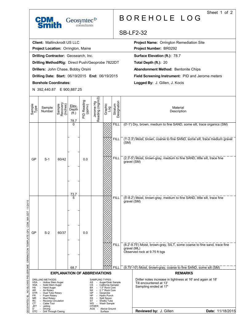
(0'-1') Dry, brown, medium to fine SAND, some silt, trace organics (SM)
(1'-2.3') Moist, brown, coarse to fine SAND, some silt, trace medium gravel(SM)
(2.3'-5') Moist, brown-gray, medium to fine SAND, little silt, trace finegravel (SM)
(5'-8.2') Moist, brown-gray, medium to fine SAND, little silt, trace finegravel (SM)
(8.2'-9.75') Moist, brown-gray, SILT, some coarse to fine sand, trace finegravel (ML)Observed rock at 9.75 ft bgs
(9.75'-10') Moist, brown-gray, coarse to fine SAND, some silt (SM)
0.0
0.0
GP
GP
60/42
60/37
S-1
S-2
Drillers: John Chase, Bobby Orsini
Drilling Date: Start: 06/19/2015 End: 06/19/2015
Borehole Coordinates:
N 392,440.87 E 900,887.25
Surface Elevation (ft.): 78.7
Total Depth (ft.): 20Drilling Method/Rig: Direct Push/Geoprobe 7822DT
Drilling Contractor: Geosearch, Inc.
Abandonment Method: Bentonite Chips
Field Screening Instrument: PID and Jerome meters
Logged By: J. Gillen, J. Kocis
DRILLING METHODS:HSASSAHAARDTRFRMRRCCTJETDDTC
Hollow Stem AugerSolid Stem AugerHand AugerAir RotaryDual Tube RotaryFoam RotaryMud RotaryReverse CirculationCable ToolJettingDrivingDrill Through Casing
OTHER:AGS -
ASCSBXNXGPHPSSSTWS
------------
SAMPLING TYPES:
Above GroundSurface
Driller notes increase in tightness at 16' and again at 18'Till encountered at 13'Sampling ended at 17'
Auger/Grab SampleCalifornia Sampler1.5" Rock Core2.1" Rock CoreGeoprobeHydro PunchSplit SpoonShelby TubeWash Sample
---------
REMARKS
Reviewed by: J. Gillen Date: 11/18/2015
EXPLANATION OF ABBREVIATIONS
Elev.Depth
(ft.)
MaterialDescription
Sam
ple
Rec
over
y(I
nche
s)
SampleNumber
Sam
ple
Typ
e
PID
Rea
ding
(ppm
v)
Jero
me
Hg
Rea
ding
(m
g/m
3)
Gra
phic
Log
Str
atum
Des
igna
tion
78.7
73.7
68.7
0
5
SB-LF2-32
B O R E H O L E L O GSheet 1 of 2
Client: Mallinckrodt US LLC
Project Location: Orrington, Maine
Project Name: Orrington Remediation Site
Project Number: BR0292
GE
OS
YN
TE
C B
L_N
O B
LOW
S P
ID/J
ER
OM
E O
RR
ING
TO
N T
EM
PLA
TE
.GP
J C
DM
_MA
.GD
T 1
1/2
4/15

FILL
FILL
ML
MLSM
ML
ML
(10'-11.5') Moist, gray-brown, coarse to fine SAND, little silt, trace finegravel (SW-SM)
(11.5'-13') Wet, gray, coarse to fine SAND and SILT, trace fine to mediumgravel (SM)
(13'-15') Wet, brown-gray, SILT and medium to fine SAND, trace finegravel (TILL)Observed stone at 14.5 ft bgs
(15.'-15.2') Wet, brown-gray, SILT, and medium to fine sand, trace finegravel (TILL)(15.2'-16.3') Wet, gray-brown, coarse to fine SAND, little silt (TILL)
(16.3'-19') Wet, brown-gray, SILT, and coarse to fine sand, trace finegravel (TILL)Observed rock at 17.4 ft bgs and 19 ft bgs
(19'-20') Wet, gray-brown, SILT, some coarse to fine sand (TILL)
End of exploration at 20 ft bgs.
0.0
0.0
GP
GP
60/42
60/41
S-3
S-4
Elev.Depth
(ft.)
MaterialDescription
Sam
ple
Rec
over
y(I
nche
s)SampleNumber
Sam
ple
Typ
e
PID
Rea
ding
(ppm
v)
Jero
me
Hg
Rea
ding
(m
g/m
3)
Gra
phic
Log
Str
atum
Des
igna
tion
68.7
63.7
58.7
53.7
10
15
20
25
SB-LF2-32
B O R E H O L E L O GSheet 2 of 2
Client: Mallinckrodt US LLC
Project Location: Orrington, Maine
Project Name: Orrington Remediation Site
Project Number: BR0292
GE
OS
YN
TE
C B
L_N
O B
LOW
S P
ID/J
ER
OM
E O
RR
ING
TO
N T
EM
PLA
TE
.GP
J C
DM
_MA
.GD
T 1
1/2
4/15

(0-10') See SB-LF2-32 boring log for lithologic descriptions.
Drillers: J. Emma, M. Rash
Drilling Date: Start: 7/20/2015 End: 7/20/2015
Borehole Coordinates:
N 392,440.87 E 900,887.25
Surface Elevation (ft.): 78.68
Total Depth (ft.): 17Drilling Method/Rig: DPT/Geoprobe 6620DT
Drilling Contractor: Geosearch, Inc.
Abandonment Method: Backfilled with bentonite chips
Field Screening Instrument: PID, Jerome MVA
Logged By: P. Donohue
DRILLING METHODS:HSASSAHAARDTRFRMRRCCTJETDDTC
Hollow Stem AugerSolid Stem AugerHand AugerAir RotaryDual Tube RotaryFoam RotaryMud RotaryReverse CirculationCable ToolJettingDrivingDrill Through Casing
OTHER:AGS -
ASCSBXNXGPHPSSSTWS
------------
SAMPLING TYPES:
Above GroundSurface
Sampled discretely from 16-17' BGS for VOCs, chloropicrin,PCBs, and cadmium. Offset of SB-LF2-32, 1' from original boringlocation. The Jerome MVA readings indicated represent thehighest recorded values in that range.
Auger/Grab SampleCalifornia Sampler1.5" Rock Core2.1" Rock CoreGeoprobeHydro PunchSplit SpoonShelby TubeWash Sample
---------
REMARKS
Reviewed by: E. Ashley Date: 10/23/2015
EXPLANATION OF ABBREVIATIONS
Elev.Depth
(ft.)
MaterialDescription
Sam
ple
Rec
over
y(I
nche
s)
SampleNumber
Sam
ple
Typ
e
PID
Rea
ding
(ppm
v)
Jero
me
Hg
Rea
ding
(m
g/m
3)
Gra
phic
Log
Str
atum
Des
igna
tion
78.7
73.7
68.7
0
5
SB-LF2-32B
B O R E H O L E L O GSheet 1 of 2
Client: Mallinckrodt US LLC
Project Location: Orrington, Maine
Project Name: Orrington Remediation Site
Project Number: 5000-110260
GE
OS
YN
TE
C B
L_N
O B
LOW
S P
ID/J
ER
OM
E L
F2.
GP
J C
DM
_MA
.GD
T 1
0/19
/15

ML
(10-16') See SB-LF2-32 boring log for lithologic descriptions.
(16-17') Moist, gray-tan, SILT, some coarse-fine angular and roundedgravel, some medium-fine sand, little clay. (ML)
End of Exploration at 17' BGS.
0.0GP 12/12S-1 0.000
Elev.Depth
(ft.)
MaterialDescription
Sam
ple
Rec
over
y(I
nche
s)SampleNumber
Sam
ple
Typ
e
PID
Rea
ding
(ppm
v)
Jero
me
Hg
Rea
ding
(m
g/m
3)
Gra
phic
Log
Str
atum
Des
igna
tion
68.7
63.7
58.7
53.7
10
15
20
25
SB-LF2-32B
B O R E H O L E L O GSheet 2 of 2
Client: Mallinckrodt US LLC
Project Location: Orrington, Maine
Project Name: Orrington Remediation Site
Project Number: 5000-110260
GE
OS
YN
TE
C B
L_N
O B
LOW
S P
ID/J
ER
OM
E L
F2.
GP
J C
DM
_MA
.GD
T 1
0/19
/15

FILL
FILL
FILL
FILL
FILL
FILL
FILL
FILL
(0'-0.7') Dry, brown, SILT, little fine sand, trace roots (ML)
(0.7'-1.9') Dry, light brown-gray, SILT, little gravel, trace fine sand (ML)
(1.9'-4.5') Dry, dark brown, fine SAND, some gravel, little silt, little clay(SP)
(4.5'-5') Moist, dark gray, medium to fine SAND, little gravel, little silt, littleclay (SM/SC)(5'-6') Moist, dark gray, SILT, some coarse to fine gravel, some clay, littlefine sand (ML)
(6'-7.3') Moist, dark yellowish brown, SILT, little clay, trace fine gravel (ML)
(7.3'-9.2') Moist, light gray-brown, medium to fine SAND, little silt, tracefine gravel (SW/SM)
(9.2'-10') Moist, dark brown, SILT, some clay, trace fine gravel, traceorganics (OL)
0.0
0.0
GP
GP
60/54
60/42
S-1
S-2
0.000
0.000
Drillers: John Chase, Bobby Orsini
Drilling Date: Start: 06/17/2015 End: 06/17/2015
Borehole Coordinates:
N 392,486.25 E 900,909.15
Surface Elevation (ft.): 75.3
Total Depth (ft.): 25Drilling Method/Rig: Direct Push/Geoprobe 7822DT
Drilling Contractor: Geosearch, Inc.
Abandonment Method: Bentonite Chips
Field Screening Instrument: PID and Jerome meters
Logged By: G. Barr, J. Kocis
DRILLING METHODS:HSASSAHAARDTRFRMRRCCTJETDDTC
Hollow Stem AugerSolid Stem AugerHand AugerAir RotaryDual Tube RotaryFoam RotaryMud RotaryReverse CirculationCable ToolJettingDrivingDrill Through Casing
OTHER:AGS -
ASCSBXNXGPHPSSSTWS
------------
SAMPLING TYPES:
Above GroundSurface
0-5 ft bgs - pressure on Geoprobe5-10 ft bgs - increased pressure~12 ft bgs - very high pressure15-20 ft bgs - very high pressure
Auger/Grab SampleCalifornia Sampler1.5" Rock Core2.1" Rock CoreGeoprobeHydro PunchSplit SpoonShelby TubeWash Sample
---------
REMARKS
Reviewed by: G. Barr Date: 11/02/2015
EXPLANATION OF ABBREVIATIONS
Elev.Depth
(ft.)
MaterialDescription
Sam
ple
Rec
over
y(I
nche
s)
SampleNumber
Sam
ple
Typ
e
PID
Rea
ding
(ppm
v)
Jero
me
Hg
Rea
ding
(m
g/m
3)
Gra
phic
Log
Str
atum
Des
igna
tion
75.3
70.3
65.3
0
5
SB-LF2-35
B O R E H O L E L O GSheet 1 of 2
Client: Mallinckrodt US LLC
Project Location: Orrington, Maine
Project Name: Orrington Remediation Site
Project Number: BR0292
GE
OS
YN
TE
C B
L_N
O B
LOW
S P
ID/J
ER
OM
E O
RR
ING
TO
N T
EM
PLA
TE
.GP
J C
DM
_MA
.GD
T 1
1/2
4/15

SW
SW
SW
GW
GW
SC
(10'-12.5') Moist-wet, yellowish brown-grayish brown, fine SAND, little silt
(12.5'-15') Moist-wet, gray-reddish brown, coarse to fine SAND, andcoarse to fine gravel, little silt, little clay (TILL)
(15'-18') Moist, dark grayish brown, coarse to fine SAND, some gravel(TILL)
(18'-20') Wet, dark brown, coarse to fine GRAVEL, some fine sand, littlesilt, little clay (TILL)
(20'-21.2') Wet, dark brown, coarse to fine GRAVEL, some fine sand, littlesilt, little clay (TILL)
(21.2'-25') Wet, gray, fine SAND, little clay (TILL)
End of exploration at 25 ft bgs.
0.0
0.0
0.0
GP
GP
GP
60/36
60/60
60/
S-3
S-4
S-5
0.000
0.000
0.000
Elev.Depth
(ft.)
MaterialDescription
Sam
ple
Rec
over
y(I
nche
s)SampleNumber
Sam
ple
Typ
e
PID
Rea
ding
(ppm
v)
Jero
me
Hg
Rea
ding
(m
g/m
3)
Gra
phic
Log
Str
atum
Des
igna
tion
65.3
60.3
55.3
50.3
10
15
20
25
SB-LF2-35
B O R E H O L E L O GSheet 2 of 2
Client: Mallinckrodt US LLC
Project Location: Orrington, Maine
Project Name: Orrington Remediation Site
Project Number: BR0292
GE
OS
YN
TE
C B
L_N
O B
LOW
S P
ID/J
ER
OM
E O
RR
ING
TO
N T
EM
PLA
TE
.GP
J C
DM
_MA
.GD
T 1
1/2
4/15

(0-10') See SB-LF2-35 boring log for lithologic descriptions.
Drillers: J. Emma, M. Rash
Drilling Date: Start: 7/20/2015 End: 7/20/2015
Borehole Coordinates:
N 392,486.25 E 900,909.15
Surface Elevation (ft.): 75.3
Total Depth (ft.): 16Drilling Method/Rig: DPT/Geoprobe 6620DT
Drilling Contractor: Geosearch, Inc.
Abandonment Method: Backfilled with bentonite chips
Field Screening Instrument: PID, Jerome MVA
Logged By: P. Donohue
DRILLING METHODS:HSASSAHAARDTRFRMRRCCTJETDDTC
Hollow Stem AugerSolid Stem AugerHand AugerAir RotaryDual Tube RotaryFoam RotaryMud RotaryReverse CirculationCable ToolJettingDrivingDrill Through Casing
OTHER:AGS -
ASCSBXNXGPHPSSSTWS
------------
SAMPLING TYPES:
Above GroundSurface
Sampled discretely from 15-16' BGS for VOCs, chloropicrin,PCBs, and cadmium. The Jerome MVA readings indicatedrepresent the highest recorded values in that range.Offset of SB-LF1-35, 1' from original boring location.
Auger/Grab SampleCalifornia Sampler1.5" Rock Core2.1" Rock CoreGeoprobeHydro PunchSplit SpoonShelby TubeWash Sample
---------
REMARKS
Reviewed by: E. Ashley Date: 10/23/2015
EXPLANATION OF ABBREVIATIONS
Elev.Depth
(ft.)
MaterialDescription
Sam
ple
Rec
over
y(I
nche
s)
SampleNumber
Sam
ple
Typ
e
PID
Rea
ding
(ppm
v)
Jero
me
Hg
Rea
ding
(m
g/m
3)
Gra
phic
Log
Str
atum
Des
igna
tion
75.3
70.3
65.3
0
5
SB-LF2-35B
B O R E H O L E L O GSheet 1 of 2
Client: Mallinckrodt US LLC
Project Location: Orrington, Maine
Project Name: Orrington Remediation Site
Project Number: 5000-110260
GE
OS
YN
TE
C B
L_N
O B
LOW
S P
ID/J
ER
OM
E L
F2.
GP
J C
DM
_MA
.GD
T 1
0/19
/15

SWG
(10-15') See LB-LF2-35 boring log for lithologic descriptions.
(15-16') Wet-saturated, gray, coarse-fine SAND and coarse-fine angularGRAVEL, little silt. (SWG)
End of Exploration at 16' BGS.
0.0GP 12/12S-1 0.000
Elev.Depth
(ft.)
MaterialDescription
Sam
ple
Rec
over
y(I
nche
s)SampleNumber
Sam
ple
Typ
e
PID
Rea
ding
(ppm
v)
Jero
me
Hg
Rea
ding
(m
g/m
3)
Gra
phic
Log
Str
atum
Des
igna
tion
65.3
60.3
55.3
50.3
10
15
20
25
SB-LF2-35B
B O R E H O L E L O GSheet 2 of 2
Client: Mallinckrodt US LLC
Project Location: Orrington, Maine
Project Name: Orrington Remediation Site
Project Number: 5000-110260
GE
OS
YN
TE
C B
L_N
O B
LOW
S P
ID/J
ER
OM
E L
F2.
GP
J C
DM
_MA
.GD
T 1
0/19
/15

FILL
FILL
FILL
FILL
FILL
(0'-2.3') Moist, brown, SILT, little fine sand, little medium to fine gravel,organics (ML)
(2.3'-5') Moist, brown, medium to fine SAND, trace medium to fine gravel,trace silt (SP-SM)
(5'-7.3') Wet, brown, medium to fine SAND, little medium to fine gravel,little silt (SP-SM)
(7.3'-9') Moist, brown, SILT, little clay, trace fine sand (ML)
(9'-10') Moist, brown, medium to fine SAND, little fine gravel, trace silt(SP-SM)
0.0
0.0
GP
GP
60/36
60/36
S-1
S-2
0.000
0.000
Drillers: John Chase, Bobby Orsini
Drilling Date: Start: 06/25/2015 End: 06/25/2015
Borehole Coordinates:
N 392,452.66 E 900,909.56
Surface Elevation (ft.): 78.0
Total Depth (ft.): 20Drilling Method/Rig: Direct Push/Geoprobe 7822DT
Drilling Contractor: Geosearch, Inc.
Abandonment Method: Bentonite Chips
Field Screening Instrument: PID and Jerome meters
Logged By: G. Barr, J. Kocis
DRILLING METHODS:HSASSAHAARDTRFRMRRCCTJETDDTC
Hollow Stem AugerSolid Stem AugerHand AugerAir RotaryDual Tube RotaryFoam RotaryMud RotaryReverse CirculationCable ToolJettingDrivingDrill Through Casing
OTHER:AGS -
ASCSBXNXGPHPSSSTWS
------------
SAMPLING TYPES:
Above GroundSurface
VOCs and Chloropicrin samples collected at 6-7 ft bgs and 7-8 ftbgsoff-set after 5 ft bgs - 1 ft bgs North
Auger/Grab SampleCalifornia Sampler1.5" Rock Core2.1" Rock CoreGeoprobeHydro PunchSplit SpoonShelby TubeWash Sample
---------
REMARKS
Reviewed by: G. Barr Date: 11/02/2015
EXPLANATION OF ABBREVIATIONS
Elev.Depth
(ft.)
MaterialDescription
Sam
ple
Rec
over
y(I
nche
s)
SampleNumber
Sam
ple
Typ
e
PID
Rea
ding
(ppm
v)
Jero
me
Hg
Rea
ding
(m
g/m
3)
Gra
phic
Log
Str
atum
Des
igna
tion
78.0
73.0
68.0
0
5
SB-LF2-36
B O R E H O L E L O GSheet 1 of 2
Client: Mallinckrodt US LLC
Project Location: Orrington, Maine
Project Name: Orrington Remediation Site
Project Number: BR0292
GE
OS
YN
TE
C B
L_N
O B
LOW
S P
ID/J
ER
OM
E O
RR
ING
TO
N T
EM
PLA
TE
.GP
J C
DM
_MA
.GD
T 1
1/2
4/15

FILL
GM-GC
CL
GM-GC
SP
SP
(10'-12.2') Wet, gray, SILT, trace fine sand (ML)
(12.2'-14.4') Moist, gray-brown, coarse to fine GRAVEL, little fine sand,trace silt, trace clay (TILL)
(14.4'-15') Moist, gray, CLAY, trace fine sand, trace silt (TILL)
(15'-19') Wet, gray, medium to fine GRAVEL, little fine sand, trace silt(TILL)
(19'-20') Moist, brown-gray, fine SAND, trace silt (TILL)
(20'-25') Wet, brown, medium to fine SAND (TILL)
End of exploration at 25 ft bgs.
0.0
0.0
0.0
GP
GP
GP
60/26.4
60/24
60/4
S-3
S-3
S-4
0.000
0.000
0.000
Elev.Depth
(ft.)
MaterialDescription
Sam
ple
Rec
over
y(I
nche
s)SampleNumber
Sam
ple
Typ
e
PID
Rea
ding
(ppm
v)
Jero
me
Hg
Rea
ding
(m
g/m
3)
Gra
phic
Log
Str
atum
Des
igna
tion
68.0
63.0
58.0
53.0
10
15
20
25
SB-LF2-36
B O R E H O L E L O GSheet 2 of 2
Client: Mallinckrodt US LLC
Project Location: Orrington, Maine
Project Name: Orrington Remediation Site
Project Number: BR0292
GE
OS
YN
TE
C B
L_N
O B
LOW
S P
ID/J
ER
OM
E O
RR
ING
TO
N T
EM
PLA
TE
.GP
J C
DM
_MA
.GD
T 1
1/2
4/15

FILL
FILL
FILL
FILL
FILL
FILL
FILL
(0-1') Moist, reddish brown, fine SAND and SILT, trace clay, trace roots.(SM)
(1-4.5') Moist-wet, gray-olive, SILT, some clay, little fine sand. (ML)
(4.5-5') Moist, gray, coarse-fine SAND, little silt. (SW)
(5-6') Same as 4.5-5' BGS.
(6-7') Wet, dark gray-black, medium-fine SAND, little silt, tracemedium-fine angular gravel. (SP)
(7-9.5') Wet, dark gray-olive gray, SILT, little clay, little medium-finerounded gravel, little medium-fine sand. (ML)
(9.5-10') Wet, light tan, with orange streaks, SILT, some coarse-fineangular gravel with clay, little medium-fine sand. (ML)
0.0
0.0
0.0
0.0
0.0
0.0
0.9
0.5
0.0
0.0
GP
GP
60/32
60/46
S-1
S-2
0.000
0.000
Drillers: J. Emma, M. Rash
Drilling Date: Start: 7/8/2015 End: 7/8/2015
Borehole Coordinates:
N 392,396.76 E 900,667.82
Surface Elevation (ft.): 71.44
Total Depth (ft.): 20Drilling Method/Rig: DPT/Geoprobe 6620DT
Drilling Contractor: Geosearch, Inc.
Abandonment Method: Backfilled with bentonite chips
Field Screening Instrument: PID, Jerome MVA
Logged By: P. Donohue
DRILLING METHODS:HSASSAHAARDTRFRMRRCCTJETDDTC
Hollow Stem AugerSolid Stem AugerHand AugerAir RotaryDual Tube RotaryFoam RotaryMud RotaryReverse CirculationCable ToolJettingDrivingDrill Through Casing
OTHER:AGS -
ASCSBXNXGPHPSSSTWS
------------
SAMPLING TYPES:
Above GroundSurface
Sampled continuously for Hg (XRF/DMA) to 20' BGS. The JeromeMVA readings indicated represent the highest recorded values inthat range.
Auger/Grab SampleCalifornia Sampler1.5" Rock Core2.1" Rock CoreGeoprobeHydro PunchSplit SpoonShelby TubeWash Sample
---------
REMARKS
Reviewed by: E. Ashley Date: 10/23/2015
EXPLANATION OF ABBREVIATIONS
Elev.Depth
(ft.)
MaterialDescription
Sam
ple
Rec
over
y(I
nche
s)
SampleNumber
Sam
ple
Typ
e
PID
Rea
ding
(ppm
v)
Jero
me
Hg
Rea
ding
(m
g/m
3)
Gra
phic
Log
Str
atum
Des
igna
tion
71.4
66.4
61.4
0
5
SB-LF2-43
B O R E H O L E L O GSheet 1 of 2
Client: Mallinckrodt US LLC
Project Location: Orrington, Maine
Project Name: Orrington Remediation Site
Project Number: 5000-110260
GE
OS
YN
TE
C B
L_N
O B
LOW
S P
ID/J
ER
OM
E L
F2.
GP
J C
DM
_MA
.GD
T 1
0/19
/15

FILL
ML
ML
(10-12.5') Same as 9.5-10' BGS, wet-saturated. Driller noted tighter drillingconditions at 12' BGS, increasing to 20' BGS.
(12.5-15') Wet, gray-light gray, SILT, some clay, little coarse-fine sand,little medium-fine angular gravel. (ML)
(15-20') Same as 12.5-15' BGS.
End of Exploration at 20' BGS.
0.0
0.0
0.0
0.0
0.0
0.0
0.0
0.0
0.0
0.0
GP
GP
60/59
60/40
S-3
S-4
0.000
0.000
Elev.Depth
(ft.)
MaterialDescription
Sam
ple
Rec
over
y(I
nche
s)SampleNumber
Sam
ple
Typ
e
PID
Rea
ding
(ppm
v)
Jero
me
Hg
Rea
ding
(m
g/m
3)
Gra
phic
Log
Str
atum
Des
igna
tion
61.4
56.4
51.4
46.4
10
15
20
25
SB-LF2-43
B O R E H O L E L O GSheet 2 of 2
Client: Mallinckrodt US LLC
Project Location: Orrington, Maine
Project Name: Orrington Remediation Site
Project Number: 5000-110260
GE
OS
YN
TE
C B
L_N
O B
LOW
S P
ID/J
ER
OM
E L
F2.
GP
J C
DM
_MA
.GD
T 1
0/19
/15

FILL
FILL
FILL
(0-0.5') Dry, dark brown, coarse-fine SAND, trace silt, trace finesub-angular gravel, trace organics. (SW)(0.5-4') Dry, brown-light tan, medium-fine SAND, little silt, littlemedium-fine angular gravel. (SP)
(4-5') Dry-moist, gray-brown, coarse-fine SAND and coarse-fine angularGRAVEL trace silt. (SW)
(5-10') Insufficient Recovery. See SB-LF2-57A for lithologic descriptiondetails.
0.0
0.0
0.0
0.0
0.0
0.0
0.0
0.0
0.0
0.0
GP
GP
60/24
60/9
S-1
S-2
0.000
0.000
Drillers: J. Emma, J. Haines
Drilling Date: Start: 7/17/2015 End: 7/17/2015
Borehole Coordinates:
N 392,346.87 E 900,649.73
Surface Elevation (ft.): 75.9
Total Depth (ft.): 15Drilling Method/Rig: DPT/Geoprobe 6620DT
Drilling Contractor: Geosearch, Inc.
Abandonment Method: Backfilled with bentonite chips
Field Screening Instrument: PID, Jerome MVA
Logged By: P. Donohue
DRILLING METHODS:HSASSAHAARDTRFRMRRCCTJETDDTC
Hollow Stem AugerSolid Stem AugerHand AugerAir RotaryDual Tube RotaryFoam RotaryMud RotaryReverse CirculationCable ToolJettingDrivingDrill Through Casing
OTHER:AGS -
ASCSBXNXGPHPSSSTWS
------------
SAMPLING TYPES:
Above GroundSurface
Sampled continuously for Hg (XRF/DMA) to 15' BGS. The JeromeMVA readings indicated represent the highest recorded values inthat range.
Auger/Grab SampleCalifornia Sampler1.5" Rock Core2.1" Rock CoreGeoprobeHydro PunchSplit SpoonShelby TubeWash Sample
---------
REMARKS
Reviewed by: E. Ashley Date: 10/23/2015
EXPLANATION OF ABBREVIATIONS
Elev.Depth
(ft.)
MaterialDescription
Sam
ple
Rec
over
y(I
nche
s)
SampleNumber
Sam
ple
Typ
e
PID
Rea
ding
(ppm
v)
Jero
me
Hg
Rea
ding
(m
g/m
3)
Gra
phic
Log
Str
atum
Des
igna
tion
75.9
70.9
65.9
0
5
SB-LF2-57
B O R E H O L E L O GSheet 1 of 2
Client: Mallinckrodt US LLC
Project Location: Orrington, Maine
Project Name: Orrington Remediation Site
Project Number: 5000-110260
GE
OS
YN
TE
C B
L_N
O B
LOW
S P
ID/J
ER
OM
E L
F2.
GP
J C
DM
_MA
.GD
T 1
0/19
/15

ML
ML
(10-13.5') Moist, brown-tan, SILT and medium-fine SAND, little coarse-fineangular and sub-angular gravel. Driller noted tighter conditions at 12' BGS.(ML)
(13.5-15') Moist, gray, SILT, some coarse-fine sand, some coarse-fineangular gravel, little clay. (ML)
End of Exploration at 15' BGS.
0.0
0.0
0.0
0.0
0.0
GP 60/60S-3 0.000
Elev.Depth
(ft.)
MaterialDescription
Sam
ple
Rec
over
y(I
nche
s)SampleNumber
Sam
ple
Typ
e
PID
Rea
ding
(ppm
v)
Jero
me
Hg
Rea
ding
(m
g/m
3)
Gra
phic
Log
Str
atum
Des
igna
tion
65.9
60.9
55.9
50.9
10
15
20
25
SB-LF2-57
B O R E H O L E L O GSheet 2 of 2
Client: Mallinckrodt US LLC
Project Location: Orrington, Maine
Project Name: Orrington Remediation Site
Project Number: 5000-110260
GE
OS
YN
TE
C B
L_N
O B
LOW
S P
ID/J
ER
OM
E L
F2.
GP
J C
DM
_MA
.GD
T 1
0/19
/15

FILL
FILL
FILL
ML
(0-5') See SB-LF2-57 for lithologic descriptions.
(5-6') Moist, brown, coarse-fine SAND, little silt. (SW)
(6-6.5') Wet, black, SILT, some clay, trace coarse-fine sand. (MH)
(6.5-7') Wet, dark gray-brown, medium-fine SAND and SILT, trace fineangular gravel. (SM)(7-10') Wet-moist, gray with black and red streaks, SILT and coarse-fineSAND, little clay, little medium-fine angular gravel. (ML)
End of Exploration at 10' BGS.
0.0
0.0
0.0
0.0
0.0
GP 60/50S-1 0.000
Drillers: J. Emma, J. Haines
Drilling Date: Start: 7/17/2015 End: 7/17/2015
Borehole Coordinates:
N 392,346.87 E 900,649.73
Surface Elevation (ft.): 75.9
Total Depth (ft.): 10Drilling Method/Rig: DPT/Geoprobe 6620DT
Drilling Contractor: Geosearch, Inc.
Abandonment Method: Backfilled with bentonite chips
Field Screening Instrument: PID, Jerome MVA
Logged By: P. Donohue
DRILLING METHODS:HSASSAHAARDTRFRMRRCCTJETDDTC
Hollow Stem AugerSolid Stem AugerHand AugerAir RotaryDual Tube RotaryFoam RotaryMud RotaryReverse CirculationCable ToolJettingDrivingDrill Through Casing
OTHER:AGS -
ASCSBXNXGPHPSSSTWS
------------
SAMPLING TYPES:
Above GroundSurface
Sampled discretely from 5-10' BGS for Hg (XRF/DMA). Offset ofSB-LF2-57, 1' from original boring location. The Jerome MVAreadings indicated represent the highest recorded values in thatrange.
Auger/Grab SampleCalifornia Sampler1.5" Rock Core2.1" Rock CoreGeoprobeHydro PunchSplit SpoonShelby TubeWash Sample
---------
REMARKS
Reviewed by: E. Ashley Date: 10/23/2015
EXPLANATION OF ABBREVIATIONS
Elev.Depth
(ft.)
MaterialDescription
Sam
ple
Rec
over
y(I
nche
s)
SampleNumber
Sam
ple
Typ
e
PID
Rea
ding
(ppm
v)
Jero
me
Hg
Rea
ding
(m
g/m
3)
Gra
phic
Log
Str
atum
Des
igna
tion
75.9
70.9
65.9
0
5
10
SB-LF2-57A
B O R E H O L E L O GSheet 1 of 1
Client: Mallinckrodt US LLC
Project Location: Orrington, Maine
Project Name: Orrington Remediation Site
Project Number: 5000-110260
GE
OS
YN
TE
C B
L_N
O B
LOW
S P
ID/J
ER
OM
E L
F2.
GP
J C
DM
_MA
.GD
T 1
0/19
/15

SW
(0-7') No sample collected. See SB-LF2-57 boring logs for lithologicdescriptions.
(7-8') Wet, tan-light brown, coarse-fine SAND, little silt, little finesub-angular gravel, trace clay. (SW)
End of Exploration at 8' BGS.
0.0GP 12/12S-1 0.000
Drillers: J. Emma, M. Rash
Drilling Date: Start: 8/10/2015 End: 8/10/2015
Borehole Coordinates:
N 392,346.87 E 900,649.73
Surface Elevation (ft.): 75.9
Total Depth (ft.): 8Drilling Method/Rig: DPT/Geoprobe 6620DT
Drilling Contractor: Geosearch, Inc.
Abandonment Method: Backfilled with bentonite chips
Field Screening Instrument: PID, Jerome MVA
Logged By: P. Donohue
DRILLING METHODS:HSASSAHAARDTRFRMRRCCTJETDDTC
Hollow Stem AugerSolid Stem AugerHand AugerAir RotaryDual Tube RotaryFoam RotaryMud RotaryReverse CirculationCable ToolJettingDrivingDrill Through Casing
OTHER:AGS -
ASCSBXNXGPHPSSSTWS
------------
SAMPLING TYPES:
Above GroundSurface
Sampled discretely from 7-8' BGS for VOCs, chloropicrin, PCBs,and cadmium. Offset of SB-LF2-56, 1' northeast of original boringlocation. The Jerome MVA readings indicated represent thehighest recorded values in that range.
Auger/Grab SampleCalifornia Sampler1.5" Rock Core2.1" Rock CoreGeoprobeHydro PunchSplit SpoonShelby TubeWash Sample
---------
REMARKS
Reviewed by: E. Ashley Date: 10/23/2015
EXPLANATION OF ABBREVIATIONS
Elev.Depth
(ft.)
MaterialDescription
Sam
ple
Rec
over
y(I
nche
s)
SampleNumber
Sam
ple
Typ
e
PID
Rea
ding
(ppm
v)
Jero
me
Hg
Rea
ding
(m
g/m
3)
Gra
phic
Log
Str
atum
Des
igna
tion
75.9
70.9
65.9
0
5
SB-LF2-57B
B O R E H O L E L O GSheet 1 of 1
Client: Mallinckrodt US LLC
Project Location: Orrington, Maine
Project Name: Orrington Remediation Site
Project Number: 5000-110260
GE
OS
YN
TE
C B
L_N
O B
LOW
S P
ID/J
ER
OM
E L
F2.
GP
J C
DM
_MA
.GD
T 1
0/26
/15


