Attachment A Preliminary Sketch Plans
49
Preliminary Sketch Plan: Isabella Weir – wetland design 35 Attachment A Preliminary Sketch Plans
Transcript of Attachment A Preliminary Sketch Plans

Preliminary Sketch Plan: Isabella Weir – wetland design 35
Attachment A Preliminary Sketch Plans


Preliminary Sketch Plan: Isabella Weir – wetland design
Attachment B Landscape Masterplan


Preliminary Sketch Plan: Isabella Weir – wetland design
Attachment C Geotechnical Report

Alluvium Pty Ltd
Isabella Pond Upgrade
Preliminary Geotechnical Investigation
29 February 2016

This page has been left intentionally blank


Coffey Geotechnics Pty Ltd ABN: 93 056 929 483 ii
Table of contents
1. Introduction .................................................................................................................................. 1 2. The site ........................................................................................................................................ 1 3. Method of investigation ............................................................................................................... 2 4. Results of investigation ............................................................................................................... 2
4.1. Subsurface conditions ....................................................................................................... 2 4.2. Laboratory testing ............................................................................................................. 3
5. Discussion and recommendations .............................................................................................. 3 5.1. Earthworks ........................................................................................................................ 3
5.1.1. Excavations .......................................................................................................... 3 5.1.2. Surface water and groundwater ........................................................................... 3 5.1.3. Presence of fill ...................................................................................................... 4
5.2. Preliminary retaining wall foundation design ..................................................................... 4 5.2.1. Shallow foundations ............................................................................................. 4 5.2.2. Deep foundations ................................................................................................. 4
Important information about your Coffey Report
Tables
Table 1 - Summary of Subsurface Conditions Table 2 - Summary of Laboratory Test Results
Figures
Figure 1 - Investigation Location Plan
Appendices
Appendix A - Engineering Borehole Logs and Explanation Sheets Appendix B - Laboratory Test Results
Isabella Pond Upgrade – Preliminary Geotechnical Investigation
Coffey GEOTFYSH09888AA-AB 29 February 2016
1
1. Introduction
This report presents the results of a preliminary geotechnical investigation carried out by Coffey Geotechnics Pty Ltd (Coffey) at Isabella Pond, located in the suburb of Monash, ACT.
The investigation was commissioned by Alluvium Pty Ltd and carried out in general accordance with our proposal, reference “GEOTFYSH09888AA-AA”, dated 25 November 2015.
We understand that the proposed upgrade works at the Isabella Pond are to include the creation of stormwater treatment wetland areas towards the northern and southern banks of the pond. The works will require the construction of retaining wall(s) set about 20-30 m from the current bank alignment within the pond.
The aim of the investigation was to assess the subsurface conditions surrounding the pond to provide preliminary comment on the likely conditions along the proposed retaining wall alignments.
2. The site
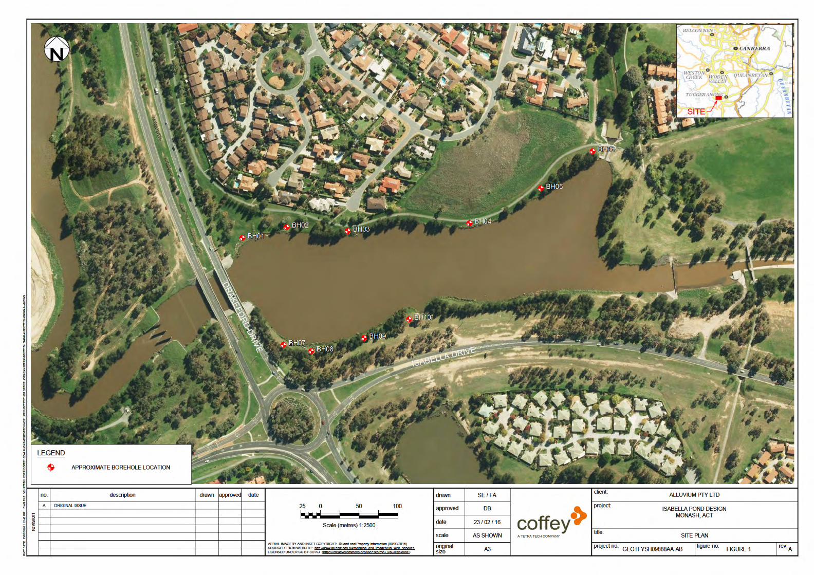
The site is located to the north east of the intersection of Isabella Drive and Drakeford Drive, 1 km SE from the centre of Tuggeranong, and is classified as Block 26, Section 55 Monash. The lake and the surrounding footpath area occupies an area of 99.5 Ha. The site is bounded to the north by houses, to the west by Drakeford Drive, to the south by Isabella Drive and to the east by vacant land / parkland.
Figure 1 shows the site and the borehole locations.
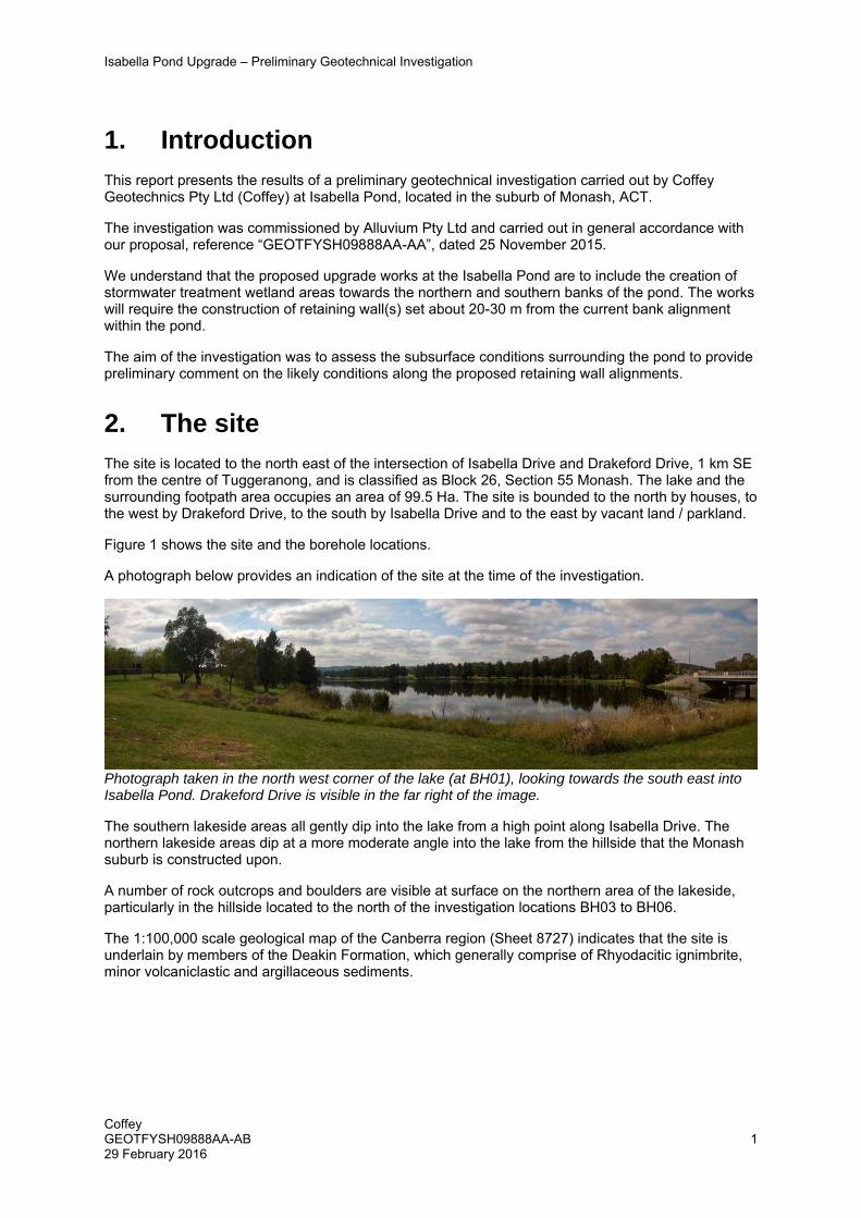
A photograph below provides an indication of the site at the time of the investigation.
Photograph taken in the north west corner of the lake (at BH01), looking towards the south east into Isabella Pond. Drakeford Drive is visible in the far right of the image.
The southern lakeside areas all gently dip into the lake from a high point along Isabella Drive. The northern lakeside areas dip at a more moderate angle into the lake from the hillside that the Monash suburb is constructed upon.
A number of rock outcrops and boulders are visible at surface on the northern area of the lakeside, particularly in the hillside located to the north of the investigation locations BH03 to BH06.
The 1:100,000 scale geological map of the Canberra region (Sheet 8727) indicates that the site is underlain by members of the Deakin Formation, which generally comprise of Rhyodacitic ignimbrite, minor volcaniclastic and argillaceous sediments.


Isabella Pond Upgrade – Preliminary Geotechnical Investigation
Coffey GEOTFYSH09888AA-AB 29 February 2016
4
5.1.3. Presence of fill
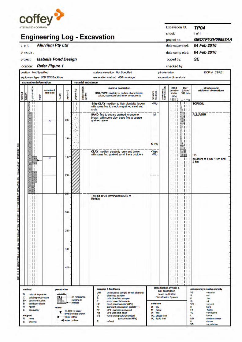
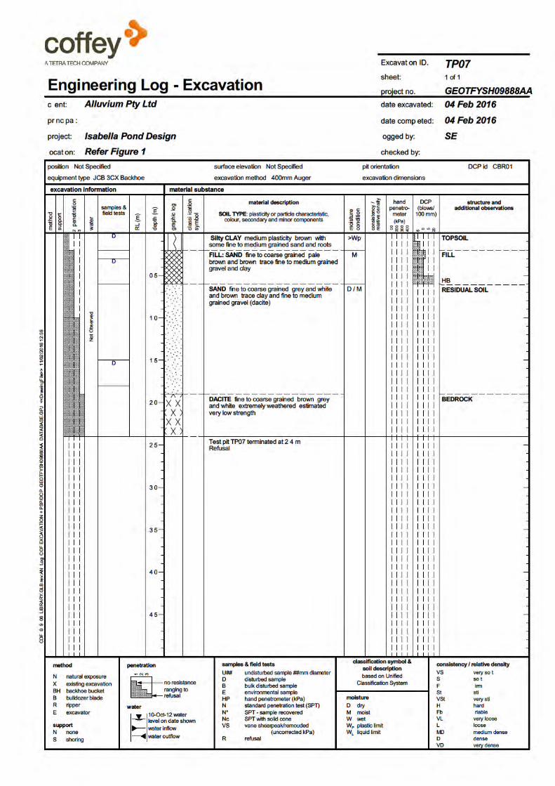
Fill was noted five of the boreholes across the site, observed to comprise of sands and clays with silts, gravels, cobbles and boulders. The presence of fill across the site is expected to be related to filling / raising works to create the current shoreline.
Unless there are records confirming that the fill has been compacted in accordance with an engineering specification, the existing fill should be classified as uncontrolled and should not be used as foundation for structures due to the potential for differential settlement.
5.2. Preliminary retaining wall foundation design
Coffey is aware that this project is in the concept stage and has not been informed of the type of retaining wall foundations that are proposed.
The advice provided below is preliminary in nature and is based upon the results of the boreholes that were excavated on the bank of Isabella Pond upto 30 m away from the proposed retaining wall location.
5.2.1. Shallow foundations
The use of pad or strip footings for support of the proposed retaining wall may be feasible where the footings are to be located within the Unit 3 Alluvial Soils, Unit 4 Residual Soils or the Unit 5 Bedrock. Pad or strip footings may be proportioned based on the following preliminary allowable bearing pressures:
Unit 3 Alluvial Soils or Unit 4 Residual Soils 100 kPa;
Unit 5 Weathered Bedrock 500 kPa.
The above values assume all footings extend a minimum of 0.5 m into the geotechnical units mentioned above. To reduce the potential for differential settlement between footings, we recommend that all footings are founded within the same geotechnical unit. Footings proportioned in accordance with the above recommendations should have load induced settlements of no greater than 1% of the footing width.
The recommended allowable bearing pressures provided above assumes that all bearing surfaces are clean and free from spoil and other soft / loose material, and free from water at the time of placement of concrete. We recommend that concrete for pad or strip footings be poured or a blinding layer of concrete be placed on any founding surfaces as soon as practical to limit the disturbance to the surface and any likely degradation of the exposed materials.
On excavation, should the ground conditions differ from those outlined above, then further advice should be sought from Coffey.
5.2.2. Deep foundations
Where uncontrolled filling is present to an uneconomical depth or where design loads exceed the above provided preliminary allowable bearing pressures; piled footings may be required to transfer loads to the underlying Unit 5 bedrock.
For limit state design, the design ultimate geotechnical pile capacity is derived by applying a geotechnical strength reduction factor (Φg) to the ultimate geotechnical pile capacity assessed using the preliminary ultimate shaft resistance and end bearing values provided below, for the Unit 5 weathered bedrock.

Isabella Pond Upgrade – Preliminary Geotechnical Investigation
Coffey GEOTFYSH09888AA-AB 29 February 2016
5
Ultimate End Bearing 1500 kPa;
Ultimate Shaft Resistance 100 kPa;
Elastic Modulus 50 MPa;
In accordance with AS2159-2009, Φg is dependent on an Average Risk Rating (ARR) which takes into account various geotechnical uncertainties, foundation system redundancy, construction supervision, quantity and type of pile testing.
Testing may provide the degree of confidence required to achieve a higher Φg value and more economical design. Coffey will review the final Φg selection at the detailed design stage.
Limit state design also required assessment of the serviceability performance of the foundation system, including pile group interactions effect. This should be carried out by an experienced geotechnical professional using well-established and soundly based methods. The modulus value given above can be used, though the accuracy of settlement prediction is dependent on construction methods as well as material stiffness, both of which can involve considerable uncertainty. Settlement predictions can have a large margin for error, and in some cases serviceability pile load testing should be completed when foundation settlement is critical to the structure’s performance.

Important information about your Coffey Report
As a client of Coffey you should know that site subsurface conditions cause more construction problems than any other factor. These notes have been prepared by Coffey to help you interpret and understand the limitations of your report.
Your report is based on project specific criteria
Your report has been developed on the basis of your unique project specific requirements as understood by Coffey and applies only to the site investigated. Project criteria typically include the general nature of the project; its size and configuration; the location of any structures on the site; other site improvements; the presence of underground utilities; and the additional risk imposed by scope-of-service limitations imposed by the client. Your report should not be used if there are any changes to the project without first asking Coffey to assess how factors that changed subsequent to the date of the report affect the report's recommendations. Coffey cannot accept responsibility for problems that may occur due to changed factors if they are not consulted. Subsurface conditions can change
Subsurface conditions are created by natural processes and the activity of man. For example, water levels can vary with time, fill may be placed on a site and pollutants may migrate with time. Because a report is based on conditions which existed at the time of subsurface exploration, decisions should not be based on a report whose adequacy may have been affected by time. Consult Coffey to be advised how time may have impacted on the project. Interpretation of factual data
Site assessment identifies actual subsurface conditions only at those points where samples are taken and when they are taken. Data derived from literature and external data source review, sampling and subsequent laboratory testing are interpreted by geologists, engineers or scientists to provide an opinion about overall site conditions, their likely impact on the proposed development and recommended actions. Actual conditions may differ from those inferred to exist, because no professional, no matter how qualified, can reveal what is hidden by earth, rock and time. The actual interface between materials may be far more gradual or abrupt than assumed based on the facts obtained. Nothing can be done to change the actual site conditions which exist, but steps can be taken to reduce the impact of unexpected conditions. For this reason, owners should retain the services of Coffey through the development stage, to identify
variances, conduct additional tests if required, and recommend solutions to problems encountered on site.
Your report will only give preliminary recommendations
Your report is based on the assumption that the site conditions as revealed through selective point sampling are indicative of actual conditions throughout an area. This assumption cannot be substantiated until project implementation has commenced and therefore your report recommendations can only be regarded as preliminary. Only Coffey, who prepared the report, is fully familiar with the background information needed to assess whether or not the report's recommendations are valid and whether or not changes should be considered as the project develops. If another party undertakes the implementation of the recommendations of this report there is a risk that the report will be misinterpreted and Coffey cannot be held responsible for such misinterpretation. Your report is prepared for specific purposes and persons
To avoid misuse of the information contained in your report it is recommended that you confer with Coffey before passing your report on to another party who may not be familiar with the background and the purpose of the report. Your report should not be applied to any project other than that originally specified at the time the report was issued.

Important information about your Coffey Report
Interpretation by other design professionals
Costly problems can occur when other design professionals develop their plans based on misinterpretations of a report. To help avoid misinterpretations, retain Coffey to work with other project design professionals who are affected by the report. Have Coffey explain the report implications to design professionals affected by them and then review plans and specifications produced to see how they incorporate the report findings. Data should not be separated from the report*
The report as a whole presents the findings of the site assessment and the report should not be copied in part or altered in any way. Logs, figures, drawings, etc. are customarily included in our reports and are developed by scientists, engineers or geologists based on their interpretation of field logs (assembled by field personnel) and laboratory evaluation of field samples. These logs etc. should not under any circumstances be redrawn for inclusion in other documents or separated from the report in any way. Geoenvironmental concerns are not at issue
Your report is not likely to relate any findings, conclusions, or recommendations about the potential for hazardous materials existing at the site unless specifically required to do so by the client. Specialist equipment, techniques, and personnel are used to perform a geoenvironmental assessment. Contamination can create major health, safety and environmental risks. If you have no information about the potential for your site to be contaminated or create an environmental hazard, you are advised to contact Coffey for information relating to geoenvironmental issues. Rely on Coffey for additional assistance
Coffey is familiar with a variety of techniques and approaches that can be used to help reduce risks for all parties to a project, from design to construction. It is common that not all approaches will be necessarily dealt with in your site assessment report due to concepts proposed at that time. As the project progresses through design towards construction, speak with Coffey to develop alternative approaches to problems that may be of genuine benefit both in time and cost. Responsibility
Reporting relies on interpretation of factual information based on judgement and opinion and has a level of uncertainty attached to it, which is far less exact than the design disciplines. This has often resulted in claims being lodged against consultants, which are unfounded. To help prevent this problem, a number of clauses have been developed for use in contracts, reports and other documents. Responsibility clauses do not transfer appropriate liabilities from Coffey to other parties but are included to identify where Coffey's responsibilities begin and end. Their use is intended to help all parties involved to recognise their individual responsibilities. Read all documents from Coffey closely and do not hesitate to ask any questions you may have. * For further information on this aspect reference should be made to "Guidelines for the Provision of Geotechnical information in Construction Contracts" published by the Institution of Engineers Australia, National headquarters, Canberra, 1987.

Figures

This page has been left intentionally blank

Appendix A - Engineering Borehole Logs and Explanation Sheets


This page has been left intentionally blank

Appendix B - Laboratory Test Results


This page has been left intentionally blank