At Street Level
33
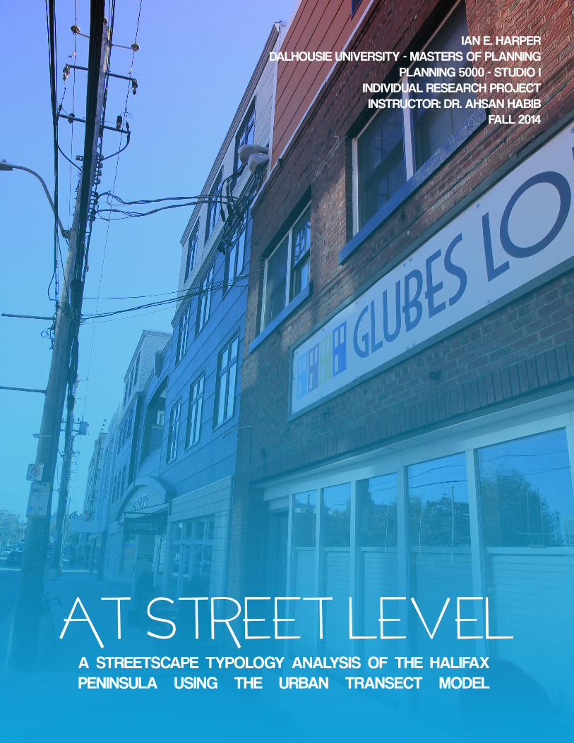
AT STREET LEVEL A STREETSCAPE TYPOLOGY ANALYSIS OF THE HALIFAX PENINSULA USING THE URBAN TRANSECT MODEL IAN E. HARPER DALHOUSIE UNIVERSITY - MASTERS OF PLANNING PLANNING 5000 - STUDIO I INDIVIDUAL RESEARCH PROJECT INSTRUCTOR: DR. AHSAN HABIB FALL 2014
-
Upload
ian-harper -
Category
Documents
-
view
214 -
download
0
Transcript of At Street Level
AT STREET LEVELA STREETSCAPE TYPOLOGY ANALYSIS OF THE HALIFAX PENINSULA USING THE URBAN TRANSECT MODEL
IAN E. HARPERDALHOUSIE UNIVERSITY - MASTERS OF PLANNING
PLANNING 5000 - STUDIO I INDIVIDUAL RESEARCH PROJECTINSTRUCTOR: DR. AHSAN HABIB
FALL 2014

“IN THE ‘URBAN’ ENVIRONMENT, THERE ARE MANY CONFLICTING
DEMANDS PLACED ON THE STREET SYSTEM, INCLUDING THOSE OF
PASSENGER CARS, TRUCKS, TRANSIT VEHICLES, CYCLISTS AND PEDESTRIANS.
IT IS IMPORTANT TO RECOGNIZE THAT THE STREET SYSTEM MUST BE
EFFECTIVELY SHARED. RIGHTS-OF-WAY IN THE ‘URBAN’ ENVIRONMENT MUST
ALSO SERVE OTHER NON-TRAFFIC NEEDS SUCH AS UTILITIES, LIGHTING,
ENVIRONMENTAL FEATURES, AND STREETSCAPING.”
(HALIFAX REGIONAL MUNICIPALITY, 2013, P. A12)

COVER PAGE: GOTTINGEN STREET (SOUTH)
&
FIRST PAGE INSET: HYDROSTONE VILLAGE, NORTHEND HALIFAX
IMAGE SOURCES: HARPER, 2014

Beautiful, welcoming, and safe streets can define a healthy and vibrant urban core; likewise, dark, unsafe and barren streetscapes can define failing or detested urban centres. “Well-designed streets can be a vital resource in social, economic and cultural terms; they can be the main component of our public realm and a core element of local and national identity” (The Scottish Government, 2010, p. 1). This study investigated streetscapes on the Halifax Peninsula, focusing on case studies of ‘Urban Centre’ and ‘Urban Core’ areas based on Duany & Plater-Zyberk’s Urban Transect Model. This micro-project was limited by duration (three weeks) and resources (single researcher).
The goal of the study is to1. Identify urban typology and characteristics (based on the Urban Transect Model) of the Halifax Peninsula, specifically in the commercial and mixed-use streetscape.2. Identify recommended actions to improve overall sustainability in Halifax through examples of effective urban streetscapes from North America.
STUDY AREAThe Halifax Peninsula is located in Halifax County, Nova Scotia, Canada. As of 2011, the Peninsula was home to 73,295 residents, 45.3% of the population make use of an automobile to get to work, 16.8% use public transit, 2.4% cycle, and 28.7% walk to work.
The north-end corridors of Gottingen Street and Agricola Street were investigated as case studies of Urban Centre zones. Downtown Halifax was analysed as an example of an Urban Core zone.
POLICY CONTEXTThe streetscapes on the Halifax Peninsula are primarily affected by two policy documents that resulted from the 2008 HRMbyDesign policy; the Downtown Halifax Master Planning Strategy (DHMPS) presents designs for the urban core, while the Centre Plan examines the areas around Agricola Street and Gottingen Street. Each policy provides the guiding principles for their respective areas, and suggests designs
that are sensitive to the surrounding buildings and community. The supplementary Schedule 1: Design Guidelines (associated with the DHMPS) lays out design guidelines for each of the nine precincts of the downtown core.
FINDINGSGottingen Street and Agricola Street share many characteristics that define their streetscapes, including:• Low- to medium-density commercial or mixed-use
buildings with commercial at grade,• Primarily flat-roof construction,• Moderately wide sidewalks of approximately 11
feet, • Automobile oriented street lighting,• Limited street trees,• Limited public seating options, and• Parallel on-street parking.
Gottingen Street possesses higher density and more-mixed use buildings than Agricola Street, including new mixed-use condominiums of six storeys. Gottingen is also experiencing rapid change, with new businesses recently affecting the streetscape; however, there still remain many vacant storefronts and lots. These vacancies provide Halifax with opportunities to implement the elements of streetscape design suggested by current policies.
Downtown Halifax possess the tallest buildings on the Peninsula, the widest variety of architectural styles, set-backs, and streetscape typologies. The DHMPS identifies nine precincts in the downtown core, each with different defining elements of the streetscape. Consistently, however, the downtown core possesses:• Medium- to high-density mixed-use buildings with
commercial at grade,• Primarily flat-roof construction (except in historic
districts or isolated heritage properties), and• Wide sidewalks (greater than 11 feet).
Some precincts, such as the Barrington Street Heritage Conservation District (BSHCD), have elements that differentiate the streetscape from other areas:• Distinctive street signs in the district,• Antique-style pedestrian-scale lighting within the
district.,• Brick or detailed sidewalks, and• Consistent with historical precedent, eight
SUMMARY
i

buildings per block with at least one storefront window per building.
Case studies of other cities around the world have found that effective urban streetscapes present the following characteristics: • Very wide sidewalks, in excess of 10 feet,• Abundant street-trees,• Priority given to pedestrians, not automobiles,• Frequent and varied public seating options,• Pedestrian-scale lighting, and• Diverse and interesting store-fronts at grade.
RECOMMENDATIONSThe guidelines expressed by planning policies, if fully implemented, would generate attractive and functional streetscapes. To date, however, many elements are missing.
1. The first recommendation is to implement street-trees as a required element for all future development along Gottingen and Agricola Street. Implement where feasible within the Downtown Core.
According to Allan Jacobs, in his book Great Streets, “trees can transform a street more easily than any other physical improvement. Moreover, for many people, trees are the most important single characteristic of a good street” (1993, p.293). Street trees are widely missing from the case study transects, yet possess many benefits. In fact, the Halifax Urban Forest Master Plan identifies Agricola and Gottingen Street as target areas for street-tree planting.
2. The second recommendation is to implement supporting policies to further promote infill development on the Halifax Peninsula. HRMbyDesign promotes infill development as an alternative to the greenfield development that is facilitating low-density suburban development in Halifax. Gottingen Street, with the abundance of vacant lots and properties, currently presents an excellent opportunity for infill development.
3. Integrate design elements, such as frequent and varied seating options, pedestrian-scale lighting, and pedestrian-oriented signage, to promote active pedestrian use of urban centres on Halifax.
With the implementation of these recommendations, the use of the design guidelines set forth in HRMbyDESIGN, the DHMPS and the Centre Plan, and consideration of the characteristics identified in international examples, the Gottingen and Agricola streetscapes can be improved to offer an excellent urban environment for the residents of Halifax. As Charles Montgomery stated, “aesthetics matter. We walk farther when streets feel safe and interesting” (2013, p. 189). If Halifax can implement these recommendations and improve the aesthetics of the streets, it can use the“redesigned streetscapes [to] encourage a culture of walking” (Halifax, 2014, p. 5), thereby reducing automobile use and the associated greenhouse gas emissions. Ultimately, Halifax is presented with an immediate opportunity to implement the strategies they have created; the question is, will the city seize it?
Figure A: Pedestrians walk along Gottingen Street, past the new EDNA eatery. This is one of the few blocks that possess street trees (Harper, 2014).
ii
IntroductionObjectivesMethodologyThe Urban Transect ModelStudy AreaElements of a StreetscapePolicies and PracticesThe Halifax Policy ContextT-5 Urban Centre Zone StudiesGottingen StreetAgricola StreetExamples of T-5 Urban Centre ZonesCook Street Village, Victoria, British ColumbiaSkaneateles, New York, USAT-6 Urban Core Zone StudyDowntown HalifaxExamples of T-6 Urban Core ZonesPortland, Oregon, USAMadison, Wisconsin, USAStreetscapes and SustainabilityWhere From Here?Implementation RecommendationsWorks Cited
TABLE OF CONTENTS12223446
811
1314
15
181920212324

TABLE OF FIGURES111235567
7999
10101212121313131414141617171718
1818
18
19
19
19192022
22
Figure 1: North Michigan Avenue, “Magnificent Mile,” Chicago, Illinois.Figure 2: Champs-Élysées, Paris, France. Figure 3: Side-street in Germany.Figure 4: The Urban Transect ModelFigure 5: Project study area, including Gottingen and Agricola Streets (T-5) and Downtown Halifax (T-6)Figure 6: East Houston Street, New York CityFigure 7: East Houston Street (Whole Foods), New York CityFigure 8: Suggested building masses for HalifaxFigure 9: Suggested building typologies by Urban Transect for HalifaxFigure 10 : How HRMbyDESIGN suggests implementing infill development in Halifax, including scaling to abutting propertiesFigure 11: Gottingen Street near Falkland, looking north, Halifax, circa 1957Figure 12: Gottingen Street at night circa 1962Figure 13: New storefronts on southern Gottingen StreetFigure 14: Gottingen Street, near Portland PlaceFigure 15: Looking north along Gottingen Street, that lacks significant variation or engaging details. Figure 16: Looking north up Agricola StreetFigure 17: Look south along Agricola StreetFigure 18: South Agricola StreetFigure 19: Cook Street Village in Victoria, BCFigure 20: Cook Street Village Store FrontFigure 21: Sidewalk Streetscape in Cook Street Village Figure 22: Downtown SkaneatelesFigure 23: Downtown SkaneatelesFigure 24: Downtown SkaneatelesFigure 25: Looking north up Barrington StreetFigure 26: Distinct street signs and lamp posts distinguish the Barrington Heritage Conservation DistrictFigure 27: Brunswick Street, looking north, along podium of new 19twenty buildingFigure 28: Brunswick Street, looking north towards Cogswell Street Figure 29: Portland’s waterfront in 1898, when Portland was the major northwest portFigure 30: Downtown Portland has very wide sidewalks, well-scaled buildings, street trees and pedestrian scale lighting. Figure 31: Transit-oriented mid-rise development in the Pearl District of PortlandFigure 32: Pioneer Place in Downtown Portland, with pedestrian scale lighting, wide ornamental sidewalks, and transit-oriented developmentFigure 33: State Street is the primary downtown “strip” of Madison, and is known for its local shops and restaurantsFigure 34: Ranked the most walkable city (in the United States) in 2007, Madison has a low accident rate for pedestrians and “tons of walking paths.” State Street has many curbside restaurantsFigure 35: Another section of State Street, again showing the many street trees, public seating, variety of store-fronts and wide sidewalksFigure 36: Wider sidewalks, public seating, and pedestrian scale lighting should be consider in Halifax Table 1: Average Customer Expenditures by Mode of Travel and Type of EstablishmentFigure 37: UFMP Implementation Strategy for the North EndFigure 38: What goes here? Vacant lot on Gottingen Street presents excellent opportunity to improve the streetscape, including commercial at grade and new street trees

Beautiful, welcoming, and safe streets can define a healthy and vibrant urban core; likewise, dark, unsafe and barren streetscapes can define failing or underutilized urban centres. “Well-designed streets can be a vital resource in social, economic and cultural terms; they can be the main component of our public realm and a core element of local and national identity” (The Scottish Government, 2010, p. 1). Famous streetscapes around the world are defined by how the different elements are combined to engage individuals, typically beyond the automobile. Examples include “The Magnificent Mile” in Chicago, Illinois (renowned as “… one of North America’s greatest shopping streets. It runs along Michigan [Avenue] through the heart of Chicago” (Di Serio, 2007))(Figure 1), Champs-Élysées, Paris (one of the most famous grand boulevards, known for its many cafés, shops, monuments and wide pedestrian walkways)(Jagannath, 2014)(Figure 2), or many of the old streets of Europe (Figure 3).
These districts each have different typologies and distinct elements that make them famous, attractive streetscapes; however, they are all linked by the variety of uses they offer to all users. “Movement along a street is vital, but it should not be considered independently of the street’s other functions. The need to cater [to cars] is well understood by designers, but the passage of people on foot and cycle has often been neglected. Walking and cycling are important modes of travel, offering a more sustainable alternative to the car, making a positive contribution to the overall character of a place, public health, social interaction and to tackling [greenhouse gas reductions]” (The Scottish Government, 2010, p. 8).
Furthermore, studies have shown that patrons that arrive by foot or by bicycle visit commercial retailers and restaurants more frequently and spend more per month, contributing more to the local economy at a lower infrastructural cost (Maus, 2012; Clifton, Morrissey, & Ritter, 2012). The scale of some of the aforementioned streetscape examples are lingering examples of the City Beautiful Movement grand avenues, something generally absent from the Halifax context. The grand avenues allow for a greater variety of transportations to be allotted designated travel areas. Narrower streets create
greater competition for space, which has typically been afforded to automobile traffic that has defined the modern cityscape. Yet, the most popular and attractive streetscapes frequently do not offer priority to automobile traffic, instead provide human-scale elements to attract pedestrians and cyclists.
Figure 1: North Michigan Avenue, “Magnificent Mile,” Chicago, Illinois (Illinois in Focus, n.d.)
Figure 2: Champs-Élysées, Paris, France (Rejseguide365, 2014).
Figure 3: Side-street in Germany (DesktopNexus.com).
INTRODUCTION
1

The study will1. Identify urban typology and characteristics (based on the Urban Transect Model) of the Halifax Peninsula, specifically within the commercial and mixed-use streetscape.2. Identify recommended actions to improve overall sustainability in Halifax through examples of effective urban streetscapes from around the world.
To systematically respond to and achieve the objectives, the following methodology was used:
1. Catalog characteristics through site visits that differentiate each urban “transect” on the Halifax Peninsula. These characteristics include, but are not limited to, building heights, set-backs, building materials, open space, sidewalk widths and treatments, landscaping, and variety of uses.
a. Urban form will be cataloged through photographs, and reviewed for similarities and differences to determine the characteristics that define Halifax’s urban transects. b. Passive observation will be used to distinguish how urban form affects the use of space between transects. c. Global Information Systems (GIS) will be used to map study area and identified transect locations on the Peninsula.
2. Conduct a literature review and gather examples of effective urban streetscapes from North America and the world to establish potential policy or form changes to improve sustainability in the region, including economic and social vitality.
a. The literature review will include analysis of planning theory from Jane Jacobs, Andrès Duany and Elizabeth Plater-Zyberk, Charles Montgomery and others. b. The streetscape examples will be gathered from journals, Internet sources, and prior personal experience.
The Urban Transect Model was popularized in the 1990s with the rise of Andrès Duany and Elizabeth Plater-Zyberk’s New Urbanist Theory. “To systemize the analysis and coding of traditional patterns, a prototypical American rural-to-urban transect has been divided into six Transect Zones, or T-zones, for application on zoning maps” (Center for Applied Transect Studies, 2013). The variety of built environments is the “…basis for organizing the components of the built world: building, lot, land use, street, and all of the other physical elements of the human habitat. In each human habitat along the rural to urban Transect, ‘immersive’ environments are created - places that have an integrity and coherence about them because of their particular combinations of element” (Duany & Plater-Zyberk, 2014).
This study will only make use of the T-5 and T-6 (Urban Centre and Urban Core) transects of the model (Figure 4). “Depending on the place, there may be fewer or more T-zones determined by analysis. For example, most towns do not have a T-6 Urban Core Zone” (CATS, 2013). T-5, or the Urban Centre Zone, refers to areas with predominantly medium-density buildings of six or less storeys. The T-6, or Urban Core Zone, is predominantly high-density buildings of greater than six-storeys (Price, 2008). The Urban Transect Model emphasizes not only building mass by zone, but also how each transect should scale into the next to provide a transition rather than abrupt shifts from low-density to high-density.
Figure 4: The Urban Transect Model (Ford, 2012).
OBJECTIVES
METHODOLOGY
THE URBAN TRANSECT MODEL
2
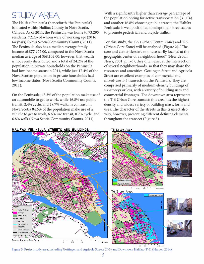
The Halifax Peninsula (henceforth ‘the Peninsula’) is located within Halifax County in Nova Scotia, Canada. As of 2011, the Peninsula was home to 73,295 residents, 72.2% of whom were of working age (20 to 64 years) (Nova Scotia Community Counts, 2011). The Peninsula also has a median average family income of $77,922.00, compared to the Nova Scotia median average of $68,102.00; however, that wealth is not evenly distributed and a total of 24.2% of the population in private households on the Peninsula had low income status in 2011, while just 17.4% of the Nova Scotian population in private households had low income status (Nova Scotia Community Counts, 2011).
On the Peninsula, 45.3% of the population make use of an automobile to get to work, while 16.8% use public transit, 2.4% cycle, and 28.7% walk; in contrast, in Nova Scotia 84.6% of the population make use of a vehicle to get to work, 6.6% use transit, 0.7% cycle, and 6.8% walk (Nova Scotia Community Counts, 2011).
With a significantly higher than average percentage of the population opting for active transportation (31.1%) and another 16.8% choosing public transit, the Halifax Peninsula is well positioned to adapt their streetscapes to promote pedestrian and bicycle traffic.
For this study, the T-5 (Urban Centre Zone) and T-6 (Urban Core Zone) will be analysed (Figure 2). “The core and center tiers are not necessarily located at the geographic center of a neighbourhood” (New Urban News, 2001, p. 1-6); they often exist at the intersection of several neighbourhoods, so that they may share the resources and amenities. Gottingen Street and Agricola Street are excellent examples of commercial and mixed-use T-5 transects on the Peninsula. They are comprised primarily of medium-density buildings of six-storeys or less, with a variety of building uses and commercial frontages. The downtown area represents the T-6 Urban Core transect; this area has the highest density and widest variety of building mass, form and uses. The character of the streets in this transect also vary, however, presenting different defining elements throughout the transect (Figure 5).
STUDY AREA
Figure 5: Project study area, including Gottingen and Agricola Streets (T-5) and Downtown Halifax (T-6) (Harper, 2014).
3

There are many elements that contribute to a streetscape, from the roofs all the way down to the material of the street and sidewalks. Many argue that the most important element of a commercial/mixed-use urban area is the storefronts. For example, “the storefront, arguably the most important segment of a commercial building, is often the portion that pedestrians and drivers notice most. … [It] establishes the visual relationship between the interior of a shop and the sidewalk, and presents the character of a business” (Portland Main Streets, 2011, p. 7). Consideration should go into every element of the storefront, including lighting, doors, signage, façade material, and windows. Other key elements play into the character of a streetscape:
• Thescaleandpositioningofstreetlights;• Thefrequency,varietyandstyleofseating;• Thesurfaceandwidthofsidewalks;• Thevegetationsizeandvariety;and• Theuseofstreetartorotherengagingelements.
Street to street, district to district, and city to city, these elements are all connected differently to provide an engaging (or not) streetscape. It is the effective combination of these elements to facilitate human engagement and interaction that creates the most memorable, attractive and sustainable streetscapes.
No two streets are identical; our interactions with the various elements on a daily basis are affected by the variations in the streetscape. “The issues around good street design are highly dependent on context and may vary considerably in their nature and complexity from one circumstance to another” (The Scottish Government, 2010, p. 11). To ensure that all streets are safe, accessible, and enjoyable, tools such as design standards and guidelines can be used. Halifax, formerly the Halifax Regional Municipality (HRM), has a series of design guidelines to govern streets, sidewalks, storm-water, lighting, trees and other streetscape elements (the full document can be accessed here: http://www.halifax.ca/designcon/design/documents/PartA-DesignGuidelines.pdf). The
purposes of these guidelines are “to provide uniform standards for the construction of infrastructure within [Halifax]” (Halifax Regional Municipality, 2013, p. A4).
Halifax General Principles for Design of Streets (HRM, 2013, p. A13)
• Streetlayout,design,andcontrolshouldexpress and reinforce street function.• Theoverallstreetnetworkshouldincludestreets designed to accommodate through traffic, in addition to local streets. • Localstreetsshouldbelinkedtohigherclassification streets in a way that provides good access to other parts of the community and region, and minimizes the chances of the local streets’ use by through traffic.• Landusesalongstreetsintendedtocarrythrough traffic should be selected and designed to minimize their sensitivity to adverse effects of traffic. When possible, uses that can benefit from the greater accessibility and public exposure that non-local streets provide should be the ones located on such streets.• Strategiesforreducingautodependencebothby residents and by others are legitimate tools of traffic management for local streets.
The primary guidelines set forth by Halifax still give significant emphasis to efficient vehicular movement with little mention of alternative modes of transportation. Only the final statement provides a non-committal nod to pedestrian and bicycle traffic. However, “on January 7, 1997, the HRM Council endorsed as policy the Transportation Association of Canada’s ‘A New Vision for Urban Transportation’…. [This policy suggests designers]:
• Planforincreaseddensitiesandmoremixedland use.• Promotewalkingasthepreferredmodeforperson trips.• Increaseopportunitiesforcyclingasanoptional mode of travel” (HRM, 2013, p. A14).
In contrast, the Scottish Government also distinguishes “roads” as spaces designed for the efficient flow of traffic, while “streets” are places for social interaction and economic activity where through traffic and parking should be discouraged. They requires that streets be considered “places” and that changes to
ELEMENTS OF A STREETSCAPE
POLICIES & PRACTICES
4
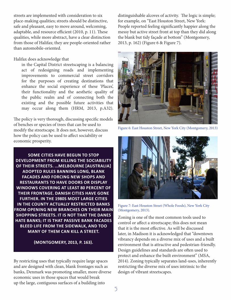
streets are implemented with consideration to six place-making qualities; streets should be distinctive, safe and pleasant, easy to move around, welcoming, adaptable, and resource efficient (2010, p. 11). These qualities, while more abstract, have a clear distinction from those of Halifax; they are people-oriented rather than automobile-oriented.
Halifax does acknowledge thatin the Capital District streetscaping is a balancing act of redesigning roads and implementing improvements to commercial street corridors for the purposes of creating destinations that enhance the social experience of these ‘Places’, their functionality and the aesthetic quality of the public realm and of connecting both the existing and the possible future activities that may occur along them (HRM, 2013, p.A32).
The policy is very thorough, discussing specific models of benches or species of trees that can be used to modify the streetscape. It does not, however, discuss how the policy can be used to affect sociability or economic prosperity.
By restricting uses that typically require large spaces and are designed with clean, blank frontages such as banks, Denmark was promoting smaller, more diverse economic uses in those spaces that would break up the large, contiguous surfaces of a building into
distinguishable alcoves of activity. The logic is simple; for example, on “East Houston Street, New York: People reported feeling significantly happier along the messy but active street front at top than they did along the blank but tidy façade at bottom” (Montgomery, 2013, p. 162) (Figure 6 & Figure 7).
Zoning is one of the most common tools used to control or affect a streetscape; this does not mean that it is the most effective. As will be discussed later, in Madison it is acknowledged that “downtown vibrancy depends on a diverse mix of uses and a built environment that is attractive and pedestrian-friendly. Design guidelines and standards are often used to protect and enhance the built environment” (MSA, 2014). Zoning typically separates land-uses, inherently restricting the diverse mix of uses intrinsic to the design of vibrant streetscapes.
SOME CITIES HAVE BEGUN TO STOP DEVELOPMENT FROM KILLING THE SOCIABILITY OF THEIR STREETS. ...MELBOURNE [AUSTRALIA]
ADOPTED RULES BANNING LONG, BLANK FACADES AND FORCING NEW SHOPS AND
RESTAURANTS TO HAVE DOORS OR DISPLAY WINDOWS COVERING AT LEAST 80 PERCENT OF THEIR FRONTAGE. DANISH CITIES HAVE GONE FURTHER. IN THE 1980S MOST LARGE CITIES
IN THE COUNTY ACTUALLY RESTRICTED BANKS FROM OPENING NEW BRANCHES ON THEIR MAIN SHOPPING STREETS. IT IS NOT THAT THE DANES HATE BANKS; IT IS THAT PASSIVE BANK FACADES
BLEED LIFE FROM THE SIDEWALK, AND TOO MANY OF THEM CAN KILL A STREET.
(MONTGOMERY, 2013, P. 163).
Figure 6: East Houston Street, New York City (Montgomery, 2013)
Figure 7: East Houston Street (Whole Foods), New York City (Montgomery, 2013).
5

THE HALIFAX POLICY CONTEXTHalifax’s urban design document, HRMbyDesign (2008), produced two planning documents that directly affect the study area: the Downtown Halifax Master Planning Strategy and the Centre Plan.
• Create economic development opportunities through new, clear, predictable and expedient approval processes;• Result in walkable and complete neighbourhoods;• Focus growth, change, and density on vacant and underutilized land (“opportunity sites”) and along major urban corridors;• Protect the character and scale of existing neighbourhoods;• Ensure that patterns of land use and transit/active transportation are mutually supportive;• Reduce HRM’s environmental footprint through the reduction in energy and resource consumption associated with dense and walkable communities;• Improve housing affordability and housing options; and,• Keep the cost of municipal services low (and thereby protect the residential tax rate) by focusing growth in areas with existing infrastructure and services.
CENTRE PLAN GOALS
1. A Sustainable Downtown: promotion of a compact, intensified and walkable downtown; strategies to promote sustainable settlement patterns,
building design and environmentally sustainable development practices.2. A Living Downtown: create distinct neighbourhoods while supporting
the creation of residential opportunities, including desirable high-density neighbourhoods with a variety of housing choices that are supported by
high quality community, streetscape and open space amenities.3. A Distinct Downtown: maintain a distinctive downtown by preserving
and reinforcing the elements that impart a sense of history, culture and a distinct natural setting.
4. A Beautiful Downtown: restore the pursuit of longevity, civic pride, visual appeal, and inspiring qualities to the design, improvement and
construction of streets, open spaces and buildings.5. A Connected Downtown: strengthen the visual and physical
connections between historical and natural assets, and civic and open space destinations in the downtown; create similar connections to
surrounding districts and neighbourhoods outside the downtown, in particular along major transit nodes and corridors.
6. A Vibrant Downtown: create a vibrant downtown by developing policies and procedures that encourage a broad mix of land uses, the required
infrastructure and the necessary critical mass to support a creative and exciting economic, cultural and social community.
SIX PRINCIPLES OF THE DOWNTOWN PLAN
Figure 8: Suggested building masses for Halifax (Halifax Regional Municipality, 2012)
6

Halifax indicates that the “appropriate building typologies” for the ‘Urban Centre Zone’ include continuous and stacked housing (such as row- or town-houses), low-rise podium form types, and mid-rise form types. Similarly, the appropriate typologies for the ‘Urban Core Zone’ are low-rise podium form types and mid-rise form types, with the potential for high-rise form types (Figure 9) (Halifax Regional Municipality, 2012).
In order to provide scaling and sensitivity to abutting properties, the HRMbyDESIGN design guidelines suggest the use of the tower-and-podium design, popular in Vancouver, British Columbia,
to ensure that the streetscape retains a pedestrian scale (Halifax, April, 2014); the podium, or base of the tower, extends out to the street and offers a smaller-scale massing, while the tower is set-back behind the base, and rises up to provide density.
Furthermore, the policy seeks to promote infill development, rather than greenfield development (Figure 10); infill development involves building on vacant lots, or re-developing underutilized lots, within an existing urban area, while greenfield developments are built on previously undeveloped land. Gottingen and Agricola Street are identified as “development hotspots” for infill development in the Centre Plan. Currently, Gottingen Street alone has four vacant lots and an empty car garage; it is easy to see why it is an ideal corridor for infill development.
HRMbyDesign seeks to provide the design guidelines and governing principles to future development in Halifax, and specifically on the Peninsula. “In the ‘urban’ environment, there are many conflicting demands placed on the street system, including those of passenger cars, trucks, transit vehicles, cyclists and pedestrians. It is important to recognize that the street system must be effectively shared. Rights-of-way in the ‘urban’ environment must also serve other non-traffic needs such as utilities, lighting, environmental features, and streetscaping” (Halifax Regional Municipality, 2013, p. A12). The guidelines call for inclusive mobility (all modes of transportation should be accommodated), the appropriate scale of buildings, a mix of uses in each neighbourhood, complete streetscapes, the infill of vacant lots in the urban environment, and community engagement (Halifax, April, 2014). According to Complete Streets for Canada, “a Complete Street is designed for all ages, abilities, and modes of travel. On Complete Streets, safe and comfortable access for pedestrians, bicycles, transit users and the mobility-impaired is not an afterthought, but an integral planning feature” (Complete Streets for Canada, 2012).
Figure 9: Suggested building typologies by Urban Transect for Halifax (Halifax Regional Municipality, 2012).
Figure 10 : How HRMbyDESIGN suggests implementing infill development in Halifax, including scaling to abutting properties (Halifax Regional Municipality, 2012).
7

GOTTINGEN S T R E E T
HARPER, 2014
T-5: URBAN CENTRE ZONE

Gottingen Street is located just north of the downtown core (Figure 5). The area has a long and tumultuous history, but has always had some commercial character. “When military property prevented the extension of Brunswick Street north of North Street,… Gottingen [Street] became the main artery of Halifax’s expanding North End. In the late 1800s and early 1900s, north Gottingen attained prestige as a residential address, and south Gottingen became a bustling centre of commerce ” (Oostveen, 2010). Unfortunately, the area was decimated by the Halifax Explosion in 1917, and many of the historic buildings were lost; the street was rebuilt with the grid pattern and general form seen today. While the area retained its commercial character (Figure 11, Figure 12), “after the Second World war, owing to demographic trends and unsuccessful urban planning, the area surrounding south Gottingen began to deteriorate, so that by the 1970s it presented an unflattering image of urban decay” (Oostveen, 2010).
Gottingen Street continued to decline in the latter half of the twentieth century due to urban renewal “slum” clearance (Roth, 2013). In more recent years, the area has begun to see reinvestment and redevelopment, often associated with gentrification. Several new mixed-use condominium buildings and commercial vendors have opened, particularly along the southern stretch of Gottingen Street. These changes are beginning to transform the streetscape, bringing new densities, storefronts, and materials to the area (Figure 13).
The surrounding area is comprised of a diverse mix of commercial, residential, community, and institutional uses within a varied built environment. According to Halifax, land uses include: various commercial, service, institutional and community uses; low to medium rise residential apartments on Gottingen Street and lower density housing forms on Maitland Street (Anguish, 2014). “Restaurants, retailers, an organic food store and a TV station have moved in, aided by the North End Business Association’s peeling away of the area’s stigma. Agricola is bustling and Gottingen is beginning to look like it did in
GOTTINGEN STREET
Figure 13: New storefronts on southern Gottingen Street (Harper, 2014).
Figure 11: Gottingen Street near Falkland, looking north, Halifax, circa 1957 (Oostveen, 2010)
Figure 12: Gottingen Street at night circa 1962 (Oostveen, 2010)
9
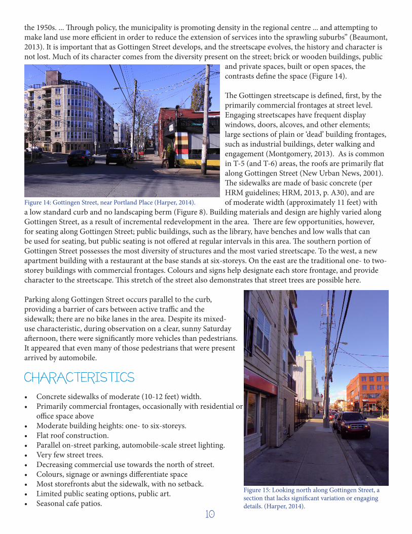
the 1950s. ... Through policy, the municipality is promoting density in the regional centre ... and attempting to make land use more efficient in order to reduce the extension of services into the sprawling suburbs” (Beaumont, 2013). It is important that as Gottingen Street develops, and the streetscape evolves, the history and character is not lost. Much of its character comes from the diversity present on the street; brick or wooden buildings, public
and private spaces, built or open spaces, the contrasts define the space (Figure 14).
The Gottingen streetscape is defined, first, by the primarily commercial frontages at street level. Engaging streetscapes have frequent display windows, doors, alcoves, and other elements; large sections of plain or ‘dead’ building frontages, such as industrial buildings, deter walking and engagement (Montgomery, 2013). As is common in T-5 (and T-6) areas, the roofs are primarily flat along Gottingen Street (New Urban News, 2001). The sidewalks are made of basic concrete (per HRM guidelines; HRM, 2013, p. A30), and are of moderate width (approximately 11 feet) with
a low standard curb and no landscaping berm (Figure 8). Building materials and design are highly varied along Gottingen Street, as a result of incremental redevelopment in the area. There are few opportunities, however, for seating along Gottingen Street; public buildings, such as the library, have benches and low walls that can be used for seating, but public seating is not offered at regular intervals in this area. The southern portion of Gottingen Street possesses the most diversity of structures and the most varied streetscape. To the west, a new apartment building with a restaurant at the base stands at six-storeys. On the east are the traditional one- to two- storey buildings with commercial frontages. Colours and signs help designate each store frontage, and provide character to the streetscape. This stretch of the street also demonstrates that street trees are possible here.
Parking along Gottingen Street occurs parallel to the curb, providing a barrier of cars between active traffic and the sidewalk; there are no bike lanes in the area. Despite its mixed-use characteristic, during observation on a clear, sunny Saturday afternoon, there were significantly more vehicles than pedestrians. It appeared that even many of those pedestrians that were present arrived by automobile.
• Concrete sidewalks of moderate (10-12 feet) width.• Primarily commercial frontages, occasionally with residential or
office space above• Moderate building heights: one- to six-storeys. • Flat roof construction.• Parallel on-street parking, automobile-scale street lighting.• Very few street trees.• Decreasing commercial use towards the north of street.• Colours, signage or awnings differentiate space• Most storefronts abut the sidewalk, with no setback. • Limited public seating options, public art.• Seasonal cafe patios.
CHARACTERISTICS
Figure 15: Looking north along Gottingen Street, a section that lacks significant variation or engaging details. (Harper, 2014).
Figure 14: Gottingen Street, near Portland Place (Harper, 2014).
10

A G R I C O L A S T R E E T
HARPER, 2014
T-5: URBAN CENTRE ZONE

HARPER, 2014
Agricola Street, like Gottingen Street, is located in the north end of Halifax, and is a medium-density primarily commercial use corridor. Present-day Agricola is known for its farmers markets, local-sourced restaurants and craft breweries. The streetscape is very similar to Gottingen, if not at a slightly smaller scale (Figure 16 and Figure 17). There are fewer buildings taller than four-storeys along Agricola than on Gottingen Street, largely due to the more residential character of the immediately surrounding neighbourhood.
The setbacks are more consistent along Agricola than along Gottingen Street, while elements such as awnings, signs, benches and tables serve to break up façade into smaller segments, welcoming pedestrian traffic (Figure 17). There are also more public seating options along Agricola, such as benches or planters. The widths and materials of sidewalks are nearly identical on Agricola Street when compared to Gottingen. The more southern portion of the street, however, has much nsidewalks (approximately 4 feet) separated from the street by a landscaping berm (Figure 18).
The current land use bylaw (LUB) for this area separates land uses, sets minimum requirements for parking, the setback distances between buildings, and maximum building heights. “These zoning tools do little to encourage complete communities with a mix of uses, walkable streets, and protection of established neighbourhoods. Phase 1 of the Centre Plan proposes updating the existing LUB to accommodate opportunities for well-designed development on this key corridor, while protecting the character and scale of surrounding neighbourhoods” (HRMbyDesign, 2013).
• Primarily two-storey commercial buildings, with no setback from sidewalks.
• Parallel curbside parking. • Automobile-scale lighting.• A variety of awnings and signs that extend from storefront to
provide a more visually engaging sight-line. • Approximately 8 to 10 feet wide concrete sidewalks. Southern
Agricola has 4 foot sidewalks with landscaping berm next to street.
AGRICOLA STREET
CHARACTERISTICS
Figure 16: Looking north up Agricola Street (Harper, 2014). Figure 17: Looking south along Agricola Street (Harper, 2014)
Figure 18: South Agricola Street (Harper, 2014)
12

Cook Street Village in Victoria, British Columbia is located approximately 2 kilometers south of the Downtown Core (Inner Harbour). The density and proximity to the downtown core of Cook Street Village is very similar to that of both Gottingen Street and Agricola Street in Halifax. “Because of the Village's pedestrian friendly streets, its small town atmosphere, and its proximity to the downtown, the area surrounding The Cook Street Village is one of Victoria's most popular destinations for…people seeking a home to purchase” (Cook Street Village Community). Cook Street Village is renowned for its social environment, boutique shops and cafes, tree-lined streets, and pedestrian and bicycle friendly space. Sidewalks are wide and often separated from the traffic by landscaping and trees, giving it a healthy and green atmosphere (Figure 19). The sidewalks use semi-permeable paver stones to reduce runoff, which is further reduced by the landscaping and trees.
The buildings are typically two to four storeys, with commercial foundations and residential upper-floors. The mix of retail shops, restaurants and cafes, and groceries provide engaging and varied storefronts and facades (Figure 20 and Figure 21). The streetscape also provides a variety of seating options and natural alcoves that foster a sense of sociability. All of these characteristics and elements combine to create a vibrant and well-used streetscape urban centre streetscape.
Set backs in Cook Street Village are larger than along Gottingen Street or Agricola because of the combination of wide-sidewalks, large landscaping berms, and street-trees (Figure 21). However, the set backs, in this case, provide more public space and seating options to users of the space, rather than creating private or inaccessible space. The many street trees buffer the public space from the road and provide parking screens.
EXAMPLES OF T-5 URBAN CENTRE ZONESCOOK STREET VILLAGE, VICTORIA , BC
Figure 19: Cook Street Village in Victoria, BC (Colliers Canada, 2014)
Figure 20: Cook Street Village Store Front (Colliers Canada, 2014)
Figure 21: Sidewalk Streetscape in Cook Street Village (CityHub, 2014)
13
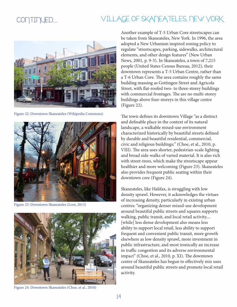
Another example of T-5 Urban Core streetscapes can be taken from Skaneateles, New York. In 1996, the area adopted a New Urbanism inspired zoning policy to regulate “streetscapes, parking, sidewalks, architectural elements, and other design features” (New Urban News, 2001, p. 9-5). In Skaneateles, a town of 7,215 people (United States Census Bureau, 2012), their downtown represents a T-5 Urban Centre, rather than a T-6 Urban Core. The area contains roughly the same building massing as Gottingen Street and Agricola Street, with flat-roofed two- to three-storey buildings with commercial frontages. The are no multi-storey buildings above four-storeys in this village centre (Figure 22).
The town defines its downtown Village “as a distinct and definable place in the context of its natural landscape, a walkable mixed-use environment characterized historically by beautiful streets defined by durable and beautiful residential, commercial, civic and religious buildings;” (Choe, et al., 2010, p. VIII). The area uses shorter, pedestrian-scale lighting and broad side-walks of varied material. It is also rich with street-trees, which make the streetscape appear healthier and more welcoming (Figure 23). Skaneateles also provides frequent public seating within their downtown core (Figure 24).
Skaneateles, like Halifax, is struggling with low density sprawl. However, it acknowledges the virtues of increasing density, particularly in existing urban centres: “organizing denser mixed-use development around beautiful public streets and squares supports walking, public transit, and local retail activity....[while] less dense development also means less ability to support local retail, less ability to support frequent and convenient public transit, more growth elsewhere as low density sprawl, more investment in public infrastructure, and most ironically an increase in traffic congestion and its adverse environmental impact” (Choe, et al., 2010, p. XI). The downtown centre of Skaneateles has begun to effectively mix uses around beautiful public streets and promote local retail activity.
VILLAGE OF SKANEATELES, NEW YORK
Figure 24: Downtown Skaneateles (Choe, et al., 2010)
Figure 23: Downtown Skaneateles (Looi, 2013)
Figure 22: Downtown Skaneateles (Wikipedia Commons)
CONTINUED....
14

D O W N T O W N H A L I F A X
T-6: URBAN CORE ZONEHARPER, 2014

The urban core of Halifax contains the highest densities and tallest buildings. It is bounded to the north by Cogswell Avenue and to the south by South Street. The western boundary is ragged, but is generally bounded by Brunswick Street and Citadel Hill. It is the urban core area that provides the best opportunity for dense, mixed-use communities that can effectively reduce per-capita green-house gas emissions (Montgomery, 2013; Owen, 2009). Montgomery refers to Alex Boston, a project manager on the North Vancouver Climate Action Plan, and his straightforward metric: “if the city [is] going to reduce its carbon foot print, it [needs] to give lots more people a chance to do a lot more things closer together. This [does] not necessarily mean building a mini-Manhattan. It [means] weaving more apartments, more town houses, more shops, and more jobs along…the city’s central spine” (Montgomery, 2013, p. 267).
Halifax’s downtown core contains districts, like the Historic Properties and the Barrington Heritage District, and has many streetscapes that present a distinct character. This section will attempt to identify the unifying characteristics that define the T-6 region of the Peninsula. According to Duany and Plater-Zyberk, the T-6 region should contain the widest sidewalks, structured parking, setbacks no greater than ten feet, and commercial frontages at street-level (New Urban News, 2001, p. 1-7). Furthermore, a key portion of the secondary Downtown Halifax Master Planning Strategy states that “The streetscape experience will be improved through redevelopment which incorporates active street level shops and activities. Infill development and redesigned streetscapes will encourage a culture of walking” (Halifax, 2014, p. 5). Figure 25 shows the variety of building forms and heights found in the T-6 zone of Halifax, with commercial storefronts at grade.
Much like the T-5 zone, buildings within the urban core (with the exception of historic landmark buildings and churches) have flat roofs. The area contains the tallest buildings on the peninsula, and the widest variety of architectural styles and building materials. HRMbyDESIGN and the Downtown Plan propose implementing density bonusing in the downtown core to trade increased density for public amenity, such as parks or public art (Halifax Regional Municipality, 2012).
HRMbyDESIGN identifies nine distinct precincts within the downtown, including: southern waterfront, Barrington Street south, Spring Garden Road, lower central downtown, Barrington Street Heritage Conservation District, upper central downtown, historic properties, Cogswell area, and the North End Gateway. Each precinct has a distinct character, and a slightly different streetscape. As a part of the Downtown Halifax LUB, Schedule S1 serves as a design manual for the previously identified precincts.
Some of the precincts identified in HRMbyDESIGN more closely resemble a T-5 Urban Centre Zone, such as Spring Garden Road. Many others, such as Barrington Street and the North End Gateway are distinct T-6 Zones.
The Barrington Street Heritage Conservation District (BSHCD) has a distinct character from the rest of the
Figure 25: Looking north along Barrington Street (Harper, 2014).
DOWNTOWN HALIFAX
16

urban core, despite sharing many characteristics. Elements such as historic style lamp posts or distinct street signs help distinguish the district from its surrounding (Figure 26). Schedule S1, subsection 2.5(e) states that new development within the BSHCD shall “respect the typical streetscape rhythm comprised of up to eight buildings in each block with one or more bay widths in each building” (p. 4). The HCD exemplifies the importance of preserving the historical character of culturally important areas, while promoting continued use and development. The Barrington HCD is currently the only Conservation District in Halifax. “The heritage
value of Barrington Street lies in the historical and architectural significance of its buildings and civic open spaces and its evolution as Halifax’s principal downtown commercial street over the 250 years from settlement to today” (Halifax, 2014).
The North End Gateway has seen significant re-development recently. Still under construction, the area has rapidly changed into a high-density mixed-use section, with uses that include residential units, hotel units, restaurants, cafes, and office space. The new 19twenty rental apartment building is in its final stages of construction, with the finishing touches added to the commercial space at grade (Figure 27). Located immediately next door is the Hampton Inn and Homewood Suites hotel complex, which also features commercial space at grade. Across the street, the much older Brunswick Heights Apartments are being renovated to add new commercial space; the commercial spaces will be built directly to the sidewalk and will provide a pedestrian-scale podium behind which the taller towers will rise (Figure 28). This new development has dramatically altered the streetscape, but will provide increased commercial destinations and more residents; the development has already began to improve the quality and width of the pedestrian infrastructure (Figure 27).
Figure 26: Distinct street signs and lamp posts distinguish the Barrington Heritage Conservation District (Harper, 2014)
While some parallel street parking is provided, most of the parking along the Northern Gateway is below grade to preserve the streetscape. The design guidelines “permit surface parking lots only when they are an accessory use and are in compliance with the Land Use By-Law and design guidelines” (2009, p. 6).
Figure 27: Brunswick Street, looking north, along podium of new 19twenty building (Harper, 2014).
Figure 28: Brunswick Street, looking north towards Cogswell Street (Harper, 2014).
17

Much like Halifax, Portland began as an important port city. The city’s urban core, therefore, formed around the industrial working harbour (Figure 29). Despite a devastating fire, there remain many historic industrial buildings in the downtown area, specifically within the now re-developed Pearl District.
Later, in the late 1800s, Portland formed one of the largest streetcar systems, which helped shape the development along a grid-pattern we see today (Metro, 2012). However, like many cities around the world, the rise of the personal automobile cause Portland to abandon streetcars in 1941 (Metro, 2012). What makes Portland so different from most North American cities is its reinvestment in the streetcar system; in 2001, Portland re-opened a streetcar system to service their central business district (CBD) (Portland Streetcar, 2014) (Figure 30 and Figure 32). Following an initial investment of $95 million USD to reinstall the streetcars, the system contributed $778,480,000 USD back into the economy (Hovee & Jordan, 2008).
As can be seen from the examples, many of the buildings in Portland’s downtown core have either been restored and re-purposed or have been scaled and built with sensitivity to abutting properties (Figure 31). Halifax, too, had a once successful streetcar line. Perhaps re-investing in a streetcar system that services the CBD can invigorate economic investment and development in the area, while promoting pedestrian and transit-oriented development and associated streetscapes.
EXAMPLES OF T-6 URBAN CORE ZONESDOWNTOWN PORTLAND, OREGON, USAHighly successful mixed-use, transit-oriented port-city urban core
Figure 29: Portland’s waterfront in 1898, when Portland was the major northwest port (Oregon Historical Society, 2002).
Figure 30: Downtown Portland has very wide sidewalks, well-scaled buildings, street trees and pedestrian scale lighting. (Armstrong, 2010).
Figure 31: Transit-oriented mid-rise development in the Pearl District of Portland (Clarke, 2010).
Figure 32: Pioneer Place in Downtown Portland, with pedestrian scale lighting, wide ornamental sidewalks, and transit-oriented development (Wikipedia Commons)
18
DOWNTOWN MADISON, WISCONSIN, USAMedium -sized lake-side city, renowned for its excellent streetscapes
Figure 33: State Street is the primary downtown “strip” of Madison, and is known for its local shops and restaurants (Brink, 2014)
Figure 34: Ranked the most walkable city (in the United States) in 2007, Madison has a low accident rate for pedestrians and “tons of walking paths.” (Castillo, 2013; Fagen, 2012).
Figure 35: Another section of State Street, again showing the many street trees, public seating, variety of store-fronts and wide sidewalks (Lydon, 2006).
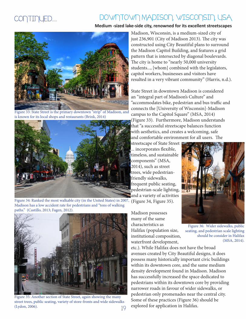
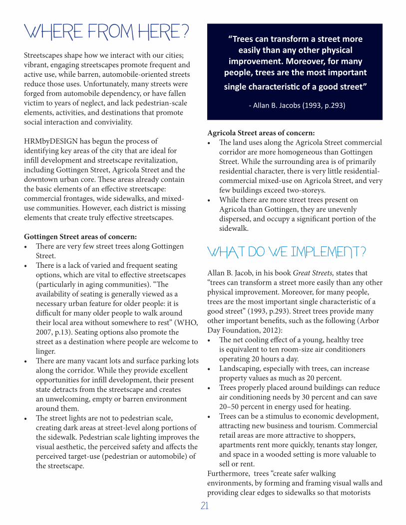
Madison, Wisconsin, is a medium-sized city of just 236,901 (City of Madison 2013). The city was constructed using City Beautiful plans to surround the Madison Capitol Building, and features a grid pattern that is intersected by diagonal boulevards. The city is home to “nearly 50,000 university students..., [whom] combined with the legislators, capitol workers, businesses and visitors have resulted in a very vibrant community” (Harris, n.d.).
State Street in downtown Madison is considered an “integral part of Madison’s Culture” and “accommodates bike, pedestrian and bus traffic and connects the [University of Wisconsin]-Madison campus to the Capitol Square” (MSA, 2014) (Figure 33). Furthermore, Madison understands that “a successful streetscape balances function with aesthetics, and creates a welcoming, safe and comfortable environment for all users. The streetscape of State Street ... incorporates flexible, timeless, and sustainable components” (MSA, 2014), such as street trees, wide pedestrian-friendly sidewalks, frequent public seating, pedestrian-scale lighting, and a variety of activities (Figure 34, Figure 35).
Madison possesses many of the same characteristics as Halifax (population size, institutional composition, waterfront development, etc.). While Halifax does not have the broad avenues created by City Beautiful designs, it does possess many historically important civic buildings within its downtown core, and the same medium density development found in Madison. Madison has successfully increased the space dedicated to pedestrians within its downtown core by providing narrower roads in favour of wider sidewalks, or pedestrian only promenades near the central city. Some of these practices (Figure 36) should be explored for application in Halifax.
Figure 36: Wider sidewalks, public seating, and pedestrian scale lighting
should be consider in Halifax (MSA, 2014).
CONTINUED....
19

STREETSCAPES & SUSTAINABILITYThe scale, appearance, and design of a street often dictate how, and how often, it is used. For example, a street that is designed with a variety of seating, pedestrian-scale lighting, and a mix of commercial, social or institutional uses, will likely attract more pedestrian traffic consistently throughout the day. In contrast, a street designed with automobile-scale lighting, expansive commercial or industrial land-uses (such as car lots), and limited seating, is likely to attract primarily automobile traffic, and only during business hours. Montgomery notes that “…the power of scale and design to open or close the doors of sociability is undeniable. ... We cannot be forced together. The richest social environments are those in which we feel free to edge closer together or move apart as we wish”(Montgomery, 2013, pp. 135-136). Furthermore, Jane Jacobs acknowledged that “on successful city streets, people must appear at different times. This time is considered on a small scale, hour by hour through the day” (Jacobs, 1961, p. 152).
Essentially, effective streetscapes improve the sociability of a space, the conviviality of a city, and can help to reduce greenhouse gas emissions by increasing pedestrian traffic. In the case of streetscapes, it appears to follow an if you build it they will come process: “‘We found that if you make more road space, you get more cars. If you make more bike lanes, you get more bikes. If you make more space for people, you get more people and of course then you get more public life’” (Jan Gehl, in Montgomery, 2013, p. 151).
The North American city, like many cities around the world, is suffering the lingering affects of automobile addiction like a bad hangover; they have been left with many streetscapes that are barren, dangerous, and unfriendly. All over the continent, magnificent examples of car-oriented strip-mall development can be found. Unfortunately, “aesthetics matter. We walk farther when streets feel safe and interesting” (Montgomery, 2013, p. 189); aesthetics are sorely lacking from these automobile-oriented streets. These large-block, automobile-oriented streets actively discourage pedestrian usage, which has negative impacts of the health of residents, the environment, and the economy.
Building for automobile transportation can also have a negative effect on the economy. Recent studies show that pedestrians and cyclists spend more per month and visit retailers more frequently in a month than automobile users (Table 1, Maus, 2012).
“The big-boxing of a city block harms the physical health of people living nearby, especially the elderly. Seniors who live among long stretches of dead frontage have actually been found to age more quickly than those who live on blocks with plenty of doors, windows, porch stoops, and destinations. Because supersize architecture and blank stretches of sidewalk push their daily destinations beyond walking distance, they get weaker and slower, they socialize less outside
the home, and they volunteer less.”
- Charles Montgomery (2013, p. 163)
Table 1: Average Customer Expenditures by Mode of Travel and Type of Establishment (Maus, 2012).
20
Streetscapes shape how we interact with our cities; vibrant, engaging streetscapes promote frequent and active use, while barren, automobile-oriented streets reduce those uses. Unfortunately, many streets were forged from automobile dependency, or have fallen victim to years of neglect, and lack pedestrian-scale elements, activities, and destinations that promote social interaction and conviviality.
HRMbyDESIGN has begun the process of identifying key areas of the city that are ideal for infill development and streetscape revitalization, including Gottingen Street, Agricola Street and the downtown urban core. These areas already contain the basic elements of an effective streetscape: commercial frontages, wide sidewalks, and mixed-use communities. However, each district is missing elements that create truly effective streetscapes.
Gottingen Street areas of concern: • There are very few street trees along Gottingen
Street.• There is a lack of varied and frequent seating
options, which are vital to effective streetscapes (particularly in aging communities). “The availability of seating is generally viewed as a necessary urban feature for older people: it is difficult for many older people to walk around their local area without somewhere to rest” (WHO, 2007, p.13). Seating options also promote the street as a destination where people are welcome to linger.
• There are many vacant lots and surface parking lots along the corridor. While they provide excellent opportunities for infill development, their present state detracts from the streetscape and creates an unwelcoming, empty or barren environment around them.
• The street lights are not to pedestrian scale, creating dark areas at street-level along portions of the sidewalk. Pedestrian scale lighting improves the visual aesthetic, the perceived safety and affects the perceived target-use (pedestrian or automobile) of the streetscape.
Agricola Street areas of concern: • The land uses along the Agricola Street commercial
corridor are more homogeneous than Gottingen Street. While the surrounding area is of primarily residential character, there is very little residential-commercial mixed-use on Agricola Street, and very few buildings exceed two-storeys.
• While there are more street trees present on Agricola than Gottingen, they are unevenly dispersed, and occupy a significant portion of the sidewalk.
WHAT DO WE IMPLEMENT? Allan B. Jacob, in his book Great Streets, states that “trees can transform a street more easily than any other physical improvement. Moreover, for many people, trees are the most important single characteristic of a good street” (1993, p.293). Street trees provide many other important benefits, such as the following (Arbor Day Foundation, 2012): • The net cooling effect of a young, healthy tree
is equivalent to ten room-size air conditioners operating 20 hours a day.
• Landscaping, especially with trees, can increase property values as much as 20 percent.
• Trees properly placed around buildings can reduce air conditioning needs by 30 percent and can save 20–50 percent in energy used for heating.
• Trees can be a stimulus to economic development, attracting new business and tourism. Commercial retail areas are more attractive to shoppers, apartments rent more quickly, tenants stay longer, and space in a wooded setting is more valuable to sell or rent.
Furthermore, trees “create safer walking environments, by forming and framing visual walls and providing clear edges to sidewalks so that motorists
WHERE FROM HERE? “Trees can transform a street more easily than any other physical
improvement. Moreover, for many people, trees are the most important single characteristic of a good street”
- Allan B. Jacobs (1993, p.293)
21

better distinguish between their environment and one shared with people... [Furthermore] businesses on treescaped streets show 12% higher income streams, which is often the essential competitive edge needed for main street store success, versus competition from plaza discount store prices” (Burden, 2006).
Figure 37: UFMP Implementation Strategy for the North End (Halifax Regional Municipality, UFMP, 2012).
Gottingen and Agricola Streets are identified in the Urban Forest Master Plan (UFMP) for tree-planting projects. Agricola was scheduled for 2013 completion, but little progress has been made, and Gottingen Street is scheduled for this year (Figure 37)(Halifax Regional Municipality, UFMP, 2012). According to the UFMP, the main commercial district of the central Peninsula (comprised of Gottingen and Agricola) currently has just a 4% canopy cover by trees (p. 300). Street trees have a nearly instantaneous effect on the streetscape, and have many known benefits; both Gottingen and Agricola Streets could be improved by their addition.
Gottingen Street currently provides the greatest opportunity for significant change. New businesses are beginning to open, bringing diversity and activity to the street; the formerly abandoned car garage has been purchased and is being renovated into a climbing gym, while the former Marquee Club will be
re-opening as a new Seahorse Tavern (known for its live music and social environment). Further north, however, many vacant lots still exist, and are excellent opportunities to implement infill development that is conscious to the needs of the surrounding neighbourhood, scaled to abutting properties, and that provides excellent and pedestrian-scaled streetscapes.
The policies and guidelines defined in the Centre Plan, Downtown Halifax Master Planning Strategy and the Urban Forest Master Plan provide the framework for improving, developing and revitalizing the urban neighbourhoods of the Peninsula. The examples of transect-specific development discussed earlier show design elements that could be considered in the Halifax context. Ultimately, Halifax is presented with an immediate opportunity to implement the strategies they have created; the question is, will the city seize the opportunity?
?
Figure 38: What goes here? Vacant lot on Gottingen Street presents excellent opportunity to improve the streetscape, including commercial at grade and new street trees (Harper, 2014).
“Great streets do not just happen. Overwhelmingly, the best streets derive from a conscious act of conception and creation of the
streets as a whole.”
- Allan B. Jacobs (1993, p. 213)
22

IMPLEMENTATION RECOMMENDATIONS
1. The first recommendation is to implement street-trees as a required element for all future development along Gottingen and Agricola Street; implement where feasible within the Downtown Core.
2. The second recommendation is to implement supporting policies to further promote infill development on the Halifax Peninsula. HRMbyDesign promotes infill development as an alternative to the greenfield development that is facilitating low-density suburban development in Halifax. Gottingen Street, with an abundance of vacant lots and properties, currently presents an excellent opportunity for infill development.
3. Finally, all new development in the urban areas of the Halifax Peninsula should integrate design elements, such as frequent and varied seating options, pedestrian-scale lighting, and pedestrian-oriented signage, to promote active pedestrian use of urban centres on Halifax.
HARPER, 2014

Anguish, B. (2014, June 17). Item No. 8.1.1. Halifax, Nova Scotia, Canada. Retrieved from http://www.halifax.ca/ Commcoun/west/documents/140617hwcc811.pdf
Armstrong, F. (2010). Portland. Wordpress Blog. Retrieved from: https://forrestarmstrong.files.wordpress. com/2010/03/portland.jpg
Beaumont, H. (2013, August 8). Pushed out by gentrification? Rising housing costs in Halifax’s north end are putting the squeeze on that diverse neighbourhood. The Coast. Retrieved from The Coast Web Site: http://www.thecoast.ca/halifax/pushed-out/Content?oid=3958457
Brink, R. V. (2014, July 16). Cities That Surprise: Madison, Wisconsin. The Frisky. Retrieved from: http://www. thefrisky.com/2014-07-16/cities-that-surprise-madison-wisconsin/
Burden, D. (2006). 22 Benefits of Urban Street Trees. Michigan: Glatting Jackson, Walkable Communities Inc.
Castillo, J. (2013). 25 Most Pedestrian Oriented And “Walkable” Cities. Geography and Travel. Retrieved from List 25: http://list25.com/25-most-pedestrian-oriented-and-walkable-cities/
Center for Applied Transect Studies. (2013). The Transect . Retrieved from CATS Web Site: http://transect.org/ transect.html
Choe, J. Y., Griffin, J., Griffin, J., Smith, R., Song, H., & Watson, C. (2010, December 17). Strategies for Sustainable Skaneateles. Notre Dame, Indiana, United States: University of Notre Dame. Retrieved November 24, 2014, from https://architecture.nd.edu/assets/76786/online_2011_02_21_book_ final_reduced_part1.pdf
City of Madison. (2013). Demographics. City of Madison DPCED: Economic Development. Retrieved from: http://www.cityofmadison.com/dpced/economicdevelopment/demographics/211/
CityHub. (2014). Cook Street Village. Retrieved November 19, 2014, from City Hub Web Site: http://cityhub.ca/ sites/victoria/files/images/3780_3424_.jpg
Clarke, D. (2010). Move LA, Part 2. LA Visions. Retrieved from: http://lavisions.blogspot.ca/2010/05/move-la- part-2.html
Clifton, K., Morrissey, S., & Ritter, C. (2012, May-June). Business Cycles: Catering to the Bicycling Market. Transportation Research News(280), 26-30.
Colliers Canada. (2014). Cook Street Properties. Retrieved November 19, 2014, from Colliers Canada Web Site: http://www.collierscanada.com/services/PropertyFile .ashx?src=p&lid=e277941eda9048c58ea47fa554b29b91&bid=ebfb5e10d526489d96f56a9720236091
Complete Streets for Canada. (2012). Home. Retrieved November 24, 2014, from Complete Streets for Canada: policy and design hub for building safe and inviting streets for all: http://completestreetsforcanada.ca/
Cook Street Village Community. (n.d.). About The Village. Retrieved November 19, 2014, from The Cook Street Village: http://www.cookstreetvillage.ca/village.php
WORKS CITED
24

Di Serio, L. (2007). The Most Awesome Streetscapes Of The World. Retrieved November 18, 2014, from Diserio: http://www.diserio.com/streetscapes.html
Duany, A., & Plater-Zyberk, E. (2014). The Urban Transect. Retrieved November 17, 2014, from Duany, Plater- Zyberk & Company Web Site: http://www.dpz.com/Initiatives/Transect
Fagen, Adam. (2012, June 21). “Looking up State Street.” Madison 2012. Retrieved from: https://www.flickr.com/ photos/afagen/8008828435/in/photostream/
Ford, J. (2012, January 20). Great Places in Balance With Nature: Beyond Low Impact Development. Retrieved from Planetizen: http://www.planetizen.com/node/54053
Halifax. (2014). Heritage Districs. Retrieved November 22, 2014, from Heritage Properties: http://www.halifax. ca/heritage-properties/BarringtonStreet.php
Halifax. (2014). Halifax Open Data. Retrieved from Halifax Open Data web site: http://catalogue.hrm.opendata. arcgis.com/datasets
Halifax Regional Municipality. (2012, April 5). HRMbyDESIGN: The Centre Plan. Halifax, Nova Scotia, Canada. Retrieved from http://www.halifax.ca/planhrm/documents/OpeningPresentation4-Apr-12.pdf
Halifax Regional Municipality. (2012). Urban Forest Master Plan. Halifax: Halifax Regional Municipality.
Halifax Regional Municipality. (2013). Municipal Design Guidelines. Retrieved November 19, 2014, from http:// www.halifax.ca/designcon/design/documents/PartA-DesignGuidelines.pdf
Halifax Regional Municipallity. (2009). Schedule S-1: Design Manual. Halifax: HRM.
Harris, G. (n.d.). Madison Streetscapes Highlight Vibrant Community. Retrieved November 26, 2014, from Landscape Online: http://landscapeonline.com/research/article/10957
Hovee, E., & Jordan, T. (2008). Streetcar-Development Linkage: The Portland Streetcar Loop. Vancouver, Washington: E. D. Hovee & Company, LLC.
Illinois in Focus. (n.d.). View of the Magnificent Mile and the Old Water Tower near the Hancock Center. Retrieved from Illinois in Focus: http://www.illinoisinfocus.com/the-magnificent-mile-and-near-north .html
Jacobs, A. B. (1993). Good Streets. Cambridge: MIT Press.
Jacobs, J. (1961). The Death and Life of Great American Cities. New York: Vintage Books.
Jagannath, T. (2014, February 16). Art In The Urban Streetscape. Retrieved November 18, 2014, from Urban Times: https://urbantimes.co/2014/02/art-in-the-urban-streetscape/
Lydon, M. (2006, February 17). Mad for Madison. New Urban Progress. Retrieved from: http:// newurbanprogress.blogspot.ca/2006_02_01_archive.html
25

Maus, J. (2012, July 6). Study shows biking customers spend more. Retrieved November 19, 2014, from Bike Portland Web Site: http://bikeportland.org/2012/07/06/study-shows-biking-customers-spend- more-74357
Montgomery, C. (2013). Happy City. Vancouver: Doubleday Canada.
MSA Professional Services. (2014). State Street Reconstruction. What We Do? Retrieved from: http://www.msa- ps.com/What-We-Do/Projects-By-State/State-Street-Reconstruction.aspx
New Urban News. (2001). New Urbanism: Comprehensive Report & Best Practices Guide (Second ed.). (R. Steuteville, Ed.) Ithaca, NY: New Urban Publications, Inc.
Nova Scotia Community Counts (2011). Halifax Peninsula. Tabulated using Statistics Canada (2012). Halifax, Nova Scotia (Code 1209) and Nova Scotia (Code 12) (table). Census Profile. 2011 Census. Statistics Canada Catalogue no. 98-316-XWE. Ottawa. Released October 24, 2012. http://www12.statcan. gc.ca/census-recensement/2011/dp-pd/prof/index.cfm?Lang=E (accessed November 12, 2014).
Oostveen, L. (2010, November 10). From the Vaults: Gottingen Street. Retrieved November 19, 2014, from Spacing:Atlantic: http://spacing.ca/atlantic/2010/11/12/from-the-vaults-gottingen-street/
Oregon Historical Society. (2002). East Portland Waterfront, 1898. Catalogue no. OrHi 925. Retrieved from: http://oregonhistoryproject.org/articles/historical-records/east-portland-waterfront-1898/#. VHdpWfldV8E
Owen, D. (2009). Green Metropolis. New York: Riverhead Books.
Portland Main Streets. (2011). Portland Main Street Design Handbook: A guide to neighborhood commercial district revitalization. Portland: Emerick Architects, P.C.Price, G. (2008, December 14). Where is this? Retrieved from Price Tags: http://pricetags.wordpress. com/2008/12/14/where-is-this/
Rejseguide365. (2014). CHAMPS-ELYSÉES: Visit the beautiful Avenue des Champs-Elysées. Retrieved from: http://www.rejseguide365.dk/paris/champs-elysees/ Roth, N. (2013). North End Halifax in Transition: A current examination of change and redevelopment on Gottingen Street. Planning . Halifax: Dalhousie Univeristy.
The Scottish Government. (2010). Designing Streets. Retrieved November 18, 2014, from Scottish Government Web Site: http://www.scotland.gov.uk/resource/doc/307126/0096540.pdf
United States Census Bureau. (2012). American Fact Finder. Retrieved November 22, 2014, from US Department of Finance: http://factfinder2.census.gov/faces/nav/jsf/pages/community_facts.xhtml World Health Organization. (2007). Global Age-friendly Cities: A Guide. Geneva: WHO Press.
26