At - environmentclearance.nic.in · SRI SAI MANASA NATURE TECH (P) LIMITED Hyderabad-500 038. 2...
77
STANDARD TEMPLATE FORM-1 PRE FEASIBILITY REPORT ENVIRONMENT MANAGEMENT PLAN & APPROVED MINING PLAN For Colour Granite Mine of SRI. U. ANJANEYULU (MINE LEASE AREA: 1.00 ha.) At Sy. No: 187 GULAPALEM VILLAGE VIRAKARUR MANDAL, ANANTHAPUR DISTRICT, ANDHRA PRADESH Prepared By SRI SAI MANASA NATURE TECH (P) LIMITED Hyderabad-500 038.
Transcript of At - environmentclearance.nic.in · SRI SAI MANASA NATURE TECH (P) LIMITED Hyderabad-500 038. 2...

STANDARD TEMPLATE
FORM-1
PRE FEASIBILITY REPORT
ENVIRONMENT MANAGEMENT PLAN
&
APPROVED MINING PLAN
For
Colour Granite Mine of
SRI. U. ANJANEYULU
(MINE LEASE AREA: 1.00 ha.)
At Sy. No: 187
GULAPALEM VILLAGE
VIRAKARUR MANDAL,
ANANTHAPUR DISTRICT,
ANDHRA PRADESH
Prepared By
SRI SAI MANASA NATURE TECH (P) LIMITED Hyderabad-500 038.


2
STANDARD TEMPLATE FOR EVALUATION OF ALL PROJECTS/ ACTIVITIES
S.No Information required Information to be furnished by the
proponent
1. Name of the project or activity Proposed Colour Granite Mine of U. ANJANEYULU
2. Name of the organization/owner. U. Anjaneyulu
3. Address for communication
S/o. Pedda Peddanna D. No: 13/189, Kasapuram Road, Valmiki Nagar, Guntakal, Ananthapur District , Andhrapradesh - 515801
4. Telephone numbers 9440686659
5. Email ID of the organization or contact
person [email protected]
6. Location of the Proposed project or
activity
Sy. No: 187 Gulapalem Village Vajrakarur Mandal Ananthapur District Andhra Pradesh
7. Appraisal Category (B2 or B1) Category B2
8. Nearest habitation and distance from
the project or activity Gulapalem - 0.7 km- West
9. Installed capacity / Production
Capacities
784 m3/annum (Maximum Production in
five years)
10. Specify the Fuel (Coal / CNG /
biomass/Others) and quantity
required
Diesel- 300 lpcd; DG set - 180 KVA
11. Details of Land use/Land Cover The Q.L area is a small hillock in the form
of Dyke. Present land use is waste land
with scrub. After prevailing of mining
operations the land use will change to
mining/ burrow areas.
12. Occupancy, ownership of the land in
which the activity is proposed:
(Government land / Private land /
Forest land /Revenue land /Temple
land /leased land/ land belongs to
other Department)
Government Land
13. If it is a Forest land, the following
details shall be furnished:
(Whether it is a Reserved forest /
Not Applicable

3
Protected forest/Demarcated forest/
National Parks/Sanctuaries/any land
in possession of Forest Department.)
(The village map with Sy. No. indicating
nearest forest boundary line from the
site shall be enclosed)
14. Total investment of the
project/activity. Rs. 45 lakh
a. Funds allocated for EMP (capital cost
and recurring cost per annum)
Rs. 1.13 Lakh (Capital Cost)
Rs. 2.13 Lakh(Recurring Cost)
15. Brief description of the project with
special reference to specific pollution
and its control measures.
During mining operations fugitive
dust emissions will be generated.
Water sprinkling will be adopted.
Noise levels may be increased during
operations and impact due to noise
will be controlled by providing ear
muffs or ear plugs to workers.
Vibrations levels will be minimum due
to shot hole drilling and blasting will
be only for short duration.
Garland drains will be provided all
along the dumps.
Solid waste generated for next 5 years
will be dumped in the SW side of
quarry lease area
16. Compliance report on the following :
i. Status of compliance of the
conditions and environmental
safeguards stipulated in the earlier
clearance letters.
Present proposal is for Environmental
Clearance
ii. Details of the court cases, if any,
pending in any Court of Law
against the project as well as any
directions passed by the Court
relating to the project directly or
indirectly.
No court case is pending against the
proposed project
iii. Details of the notices, if any, given
to the project under Section 5 of
the Environmental (Protection)
Act, 1986 and Section 18 of the Air
(Prevention & Control of Pollution)
Act, 1981.
No

4
17 Whether the project attracts the
provisions laid under the OM
dt.16.11.2010 issued by the MoEF,
GOI, w.r.t. violation of EIA Notification,
2006 and its amendments there of ?
(Yes / No)
No
Present stage and status of the Project : New Mine.
18 Name of the Consultant: M/s. Sri Sai Manasa Nature Tech
Private Limited

I
II
FORM 1
(I) Basic Information
Sl.No. Item Details
1. Name of the project/s Proposed Colour Granite mine of Sri. U. Anjaneyulu
2. S.No. in the schedule Item- 1(a) Mining of Minerals
3. Proposed capacity /area /length/ tonnage to be handled/ command area/ lease area/number of wells to be drilled.
784 m3/ annum (Maximum Production in five years); Mining Lease area : 1.00 Hectares
4. New/Expansion/Modernization New
5. Existing Capacity/Area etc. Not Applicable
6. Category of Project i.e. ‘A’ or ‘B’ Category ‘B’ (B2)
7. Does it attract the general condition? If yes, please specify.
No
8. Does it attract the specific condition? If yes, please specify. No
9. Location
Plot/Survey/Khasra No. Village Tehsil District State
150 05’ 31.05” N 770 22’ 57.38” E Sy. No: 187 Gulapalem Village Vajrakarur Mandal Ananthapur District Andhra Pradesh
10. Nearest railway station/Port along with distance in km.
Gunthakal Railway station – 9 km (N) Satya Sai Airport(Puthaparthi)-113km(SE)
11. Nearest Town, city, district Headquarters along with distance in kms.
Gunthaka – 8 km(N) Ananthapur District – 45 km (SE)
12. Village Panchayats, Zilla Parishad, Municipal Corporation, Local body (complete postal addresses with telephone nos. to be given)
Gulapalem Village Panchayat / Gunthakal Muncipality
13. Name of the applicant U. Anjaneyulu
14. Registered Address S/o. Pedda Peddanna D. No: 13/189, Kasapuram Road, Valmiki Nagar, Guntakal, Ananthapur District , Andhrapradesh - 515801

III
15. Address for correspondence: Name Designation (Owner/Partner /CEO) E-mail Telephone No. Fax No.
U. Anjaneyulu Proprietor [email protected] 9440686659 Nil 7YM4P94O
16. Details of Alternative Sites examined, if any. Location of these sites should be shown on a topo sheet.
The mineral being extracted is site specific and hence no alternative sites were examined.
17. Interlinked Projects Nil
18. Whether separate application of interlinked project has been submitted? Not applicable
19. If yes, date of submission Not applicable
20. If no, reason Not applicable
21. Whether the proposal involves approval/clearance under: if yes, details of the same and their status to be given. i. The Forest (Conservation) Act,
1980? ii. The Wildlife (Protection) Act, 1972? iii. The C.R.Z. Notification, 1991?
No.
22. Whether there is any Government Order/Policy relevant /relating to the site?
Yes. .
1. Mining Plan approval Letter Number 2441/MP-ATP/2015,dated 19.11.2015 -Joint Director of Mines & Geology, Hyderabad.
23. Forest land involved (hectares) No forest land is involved
24. Whether there is any litigation pending against the project and/or land in which the project is propose to be set up? a) Name of the Court b) Case No. c) Orders/directions of the Court, if any
and its relevance with the proposed project.
No litigation or court case is pending against the proposed project.

IV
(II) Activity
1. Construction, operation or decommissioning of the Project involving actions, which
will cause physical changes in the locality (topography, land use, changes in water
bodies, etc.)
S.No.
Information/Checklist
confirmation
Yes/No
Details thereof (with approximate
quantities/rates, wherever
possible) with source of
information data
1.1 Permanent or temporary change in
land use, land cover or topography
including increase in intensity of
land use (with respect to local land
use plan)
Yes
There will be permanent change in land use and topography due to the proposed activity.
Present land use is waste land with scrubs. This will be changed to mining / burrow area.
Topography of the lease area is a small hill. Dyke with gently slope towards NW & SE with a dip of 5-6 degrees.
1.2 Clearance of existing land, vegetation
and buildings? No
There are no buildings and
vegetation is sparse in lease area.
1.3 Creation of new land uses?
Yes Present land use will be changed
with commencement of mining
activities. After completion of mining
activities, the mined out pit will be
back filled with waste material.
1.4 Pre-construction investigations e.g.
bore houses, soil testing? Yes
Preliminary investigations have
been carried out at the QL area and
mining plan has been prepared.
1.5 Construction works? Yes Office room and rest shelters will be
constructed in the ML area.
1.6 Demolition works? No
There are no buildings in the quarry
lease area. Hence, no demolition
works envisaged.
1.7
Temporary sites used for
construction works or housing of
construction workers?
No Not envisaged.
1.8
Above ground buildings, structures
or earthworks including linear
structures, cut and fill or
excavations
Yes
Mining of granite will be carried out
by opencast semi mechanized
method.

V
1.9 Underground works including mining
or tunneling? No
The mining will be carried out by Open cast semi mechanized mining method. No underground mining or tunneling is envisaged.
1.10 Reclamation works? Yes In proposed lease area, reclamation will be taken up after economically viable depth is explored.
1.11 Dredging? No Not applicable
1.12 Offshore structures? No Not applicable
1.13 Production and manufacturing
processes?
Yes About 784 m3/annum of Colour Granite will be mined. Mining will be carried out by opencast semi mechanized method by using an excavator, tippers, compressors and jackhammers.
1.14 Facilities for storage of goods or
materials? Yes
Stock yard and waste dump yard facilities are identified for storage of goods and materials in ML area.
1.15 Facilities for treatment or disposal of
solid waste or liquid effluents? Yes
Waste will be dumped in the South
west side of the lease area.
1.16 Facilities for long term housing of
operational workers? No Not envisaged
1.17 New road, rail or sea traffic during
construction or operation?
Yes Additional traffic will be created due to the movement of mined granite blocks.
Haul roads will be paved in the lease area for movement of trucks. No new rail network or sea route is proposed for the mining project. Existing road network will be used.
1.18 New road, rail, air waterborne or other
transport infrastructure including new
or altered routes and stations, ports,
airports etc?
No
Existing facilities will be used. No
other major road, rail, air
waterborne transport network is
envisaged for the mining project.
1.19 Closure or diversion of existing
transport routes or infrastructure
leading to changes in traffic
movements?
No
No closure or diversion of existing
transport routes or infrastructure is
involved during mining operation.
1.20 New or diverted transmission lines or
pipelines? No Not envisaged.
1.21 Impoundment, damming, culverting,
realignment or other changes to the
hydrology of watercourses or
aquifers?
No
Not envisaged.

VI
1.22 Stream crossings? No No seasonal nalas are passing
through the mining lease area.
1.23 Abstraction or transfers of water
from ground or surface waters? Yes
Water required for the mining
activities will be sourced through
water tankers..
1.24 Changes in water bodies or the land
surface affecting drainage or run-off? No
There are no perennial/ seasonal
watercourses exist in this area.
1.25
Transport of personnel or materials
for construction, operation or
decommissioning?
No
The mined out minerals will be
transported to consumers by
trucks
1.26
Long-term dismantling or
decommissioning or restoration
works?
No Not envisaged.
1.27
Ongoing activity during
decommissioning which could have
an impact on the environment?
No Not envisaged.
1.28 Influx of people to an area in either
temporarily or permanently? No
No influx of people is envisaged
as the total manpower required
during operational stage is 24
including labor
1.29 Introduction of alien species? No Not envisaged.
1.30 Loss of native species or genetic
diversity? No Not envisaged.
1.31 Any other actions? No Not envisaged.
2. Use of Natural resources for construction or operation of the Project (such as
land, water, materials or energy, especially any resources which are
non-renewable or in short supply) :
S. No. Information/checklist
confirmation Yes/No
Details thereof (with
approximate quantities /rates,
wherever possible) with source
of information data
2.1 Land especially undeveloped or
agricultural land (ha) Yes
The quarry lease area is
Government land. No cultivation is
carried out in quarry lease area
2.2 Water (expected source &
competing users) unit: KLD Yes
Total water requirement of the
mining operations is about 10.0
KL per day. Water will be sourced
through water tankers or nearby
Villages.

VII
2.3 Minerals (MT) No
Not applicable
2.4
Construction material–stone,
aggregates, sand/ soil (expected
source – MT)
Yes
Common office room and rest
shelter is proposed. Requirement
of small quantities construction
materials are sourced from nearby
areas.
2.5 Forests and timber (source – MT)
No Not applicable
2.6
Energy including electricity and fuels
(source, competing users) Unit: fuel
(MT), energy (MW)
Yes
This is open cast semi mechanized
mining. 300 liters/day of Diesel
will be used for quarrying
operations. A common DG set of
180 kvA is used
2.7
Any other natural resources (use
appropriate standard units)
No Not applicable
3. Use, storage, transport, handling or production of substances or materials which
could be harmful to human health or the environment or raise
concerns about actual or perceived risks to human health.
S. No. Information/ Checklist
confirmation Yes/ No
Details thereof (with approximate quantities /rates, wherever possible) with source
of information data 3.1 Use of substances or materials,
which are hazardous (as per MSIHC
rules) to human health or the
environment (flora, fauna, and water
supplies) Yes
Special explosives and silent non
explosive demolishing agents will
be used for blasting. Portable
magazine will be located at a safe
distance from the quarry. Rules
and regulations laid down for safe
storage and handling of explosives
as per explosives Act will be
strictly followed.
3.2
Changes in occurrence of disease or
affect disease vectors (e.g. insect or
water borne diseases)
No Not envisaged.
3.3 Affect the welfare of people e.g. by
changing living conditions? Yes
The proposed activity will provide
employment to the nearby village
thereby increasing their
economical status.

VIII
3.4
Vulnerable groups of people who
could be affected by the project e.g.
hospital patients, children, the
elderly etc.,
No Not envisaged.
3.5 Any other causes No Not envisaged.
4. Production of solid wastes during construction or operation or decommissioning
(MT/month)
S. No. Information/Checklist
confirmation Yes/No
Details there of (with approximate quantities/ rates,
wherever possible) with source of information data
4.1 Spoil, overburden or mine wastes
Yes
Total mine waste of about 109364
m3 will be generated during the
five years. Solid waste will be
dumped in South west side of the
area.
4.2 Municipal waste (domestic and or
commercial wastes) Yes
Very little quantity from office and
rest shelters.
4.3 Hazardous wastes (as per Hazardous
Waste Management Rules) Yes
Used oil will be disposed as per the
Hazardous waste management
rules.
4.4 Other industrial process wastes No Not envisaged
4.5 Surplus product No Not envisaged
4.6 Sewage sludge or other sludge from
effluent treatment No Not envisaged
4.7 Construction or demolition wastes No Not envisaged
4.8 Redundant machinery or equipment No Not envisaged
4.9 Contaminated soils or other
materials No Not envisaged
4.10 Agricultural wastes No Not Generated the agriculture
waste
4.11 Other solid wastes No Not envisaged

IX
5. Release of pollutants or any hazardous, toxic or noxious substances to air
(Kg/hr)
S. No. Information/Checklist
confirmation Yes/ No
Details thereof (with approximate quantities/rates,
wherever possible) with source of information data
5.1
Emissions from combustion of
fossil fuels from stationary or mobile
sources Yes
Emissions will be generated for
HEMM used for mining activities
and from trucks used for
transportation activities
5.2 Emissions from production processes Yes
Fugitive dust will be generated
from mining activities. Adequate
control measures like water
sprinkling will be taken to control
fugitive dust.
5.3 Emissions from materials handling
including storage or transport Yes
Emissions will be generated from
blasting and transport.
5.4
Emissions from construction
activities including plant and
equipment
No No major construction activities
are envisaged.
5.5
Dust or odors from handling of
materials including construction
materials, sewage and waste Yes
Dust will be generated during
mining and transportation of
materials. However, odor is not
envisaged.
5.6 Emissions from incineration of waste No Not envisaged
5.7 Emissions from burning of waste in open air (e.g. slash materials, construction debris)
No Not envisaged
5.8 Emissions from any other sources No Not envisaged
6. Generation of Noise and Vibration, and Emissions of Light and Heat:
S. No. Information/Checklist
confirmation Yes/ No
Details thereof (with approximate quantities/rates,
wherever possible) with source of information data
6.1 From operation of equipment e.g.
engines, ventilation plant, crushers Yes
Noise will be generated from
transport vehicles, machinery and
drilling operations.
6.2 From industrial or similar processes No Not envisaged
6.3 From construction or demolition No No major construction/
demolitions are envisaged
X
6.4 From blasting or piling Yes
Noise will be generated during
blasting operation, which will be
instantaneous in nature.
6.5 From construction or operational
traffic Yes
Noise will be generated from the
trucks deployed for transportation
of mined material
6.6 From lighting or cooling systems No Not envisaged
6.7 From any other sources No Not envisaged
7. Risks of contamination of land or water from releases of pollutants into the
ground or into sewers, surface waters, groundwater, coastal waters or the sea:
S. No. Information/Checklist
confirmation Yes/ No
Details thereof (with approximate quantities/ rates, wherever possible) with source
of information data
7.1 From handling, storage, use or
spillage of hazardous materials No Not envisaged.
7.2
From discharge of sewage or other
effluents to water or the land
(expected mode and place of
discharge)
No Not envisaged.
7.3 By deposition of pollutants emitted to
air into the land or into water No Not envisaged.
7.4 From any other sources No -
7.5
Is there a risk of long term build up of
pollutants in the environment from
these sources? No -
8. Risk of accidents during construction or operation of the Project, which could affect
human health or the environment
S. No. Information/Checklist
confirmation Yes/No
Details thereof (with approximate quantities/rates,
wherever possible) with source of information data
8.1 From explosions, spillages, fires etc.
from storage, handling, use or
production of hazardous substances
No Explosives used for blasting will be
stored at a safe distance from the
quarry. Rules and regulations laid
down for safe storage and handling
of explosives as per the explosives
act will be strictly followed.
XI
8.2 From any other causes No Not envisaged.
8.3 Could the project be affected by
natural disasters causing
environmental damage
(e.g. floods, earthquakes, landslides,
cloudburst etc.)?
No Not envisaged.
9. Factors which should be considered (such as consequential development) which
could lead to environmental effects or the potential for cumulative impacts with
other existing or planned activities in the locality.
S. No. Information/Checklist
confirmation Yes/No
Details thereof (with approximate quantities/ rates, wherever
possible) with source of information data
9.1 Lead to development of supporting
facilities, ancillary development or
development stimulated by the project
which could have impact on the
environment e.g. :
Supporting infrastructure (roads,
power supply, waste or
wastewater treatment, etc.)
Housing
Development
Extractive industries
Supply industries
Other
Yes
Supporting and ancillary
development will take place.
Not envisaged.
9.2 Lead to after-use of the site, which
could have an impact on the
environment
Yes Reclamation will be done with
backfilling the waste into mined
out pit. Afforestation will be done
by spreading the soil on backfilled
area. Hence there will be positive
impact on the mine lease area.
9.3 Set a precedent for later developments Yes Ancillary industries will be
developed as a consequence.
9.4 Have cumulative effects due to
proximity to other existing or
planned projects with similar effects
Yes Dust accumulation on the roads.

XII
(III) Environmental Sensitivity
S. No. Areas Name/
Identity
Aerial distance (within
15km.) Proposed
project location
boundary
1.
Areas protected under
international conventions,
national or local legislation for
their ecological, landscape,
cultural or other related value.
Nill None
2. Areas which are important or
sensitive for ecological reasons
- Wetlands, watercourses or
other water bodies, coastal
zone, biospheres, mountains,
forests.
Reserved Forest
Water Bodies
Tungabhadra High Level
Canal -
Pedda Vanka -
None
6.03 km W
8.58 km W
3. Areas used by protected,
important or sensitive
species of flora or fauna for bre
eding, nesting, foraging,
resting, over wintering,
migration
None -
4. Inland, coastal, marine or
underground waters None -
5. State, National boundaries
Andhra – Karnataka
25 Km – West
6. Routes or facilities used by the
public for access to recreation
or other tourist, pilgrim area
None -
7. Defense installations None -
8. Densely populated or built-up
area None ---
9. Areas occupied by sensitive
man-made land uses hospitals,
schools, places of worship,
community facilities)
Hospitals, schools and
temples are available in
the surrounding villages
Hospitals, schools and
temples are available in
the surrounding villages

XIII
10. Areas containing important,
high
quality or scarce resources
(ground water resources,
surface resources, forestry,
agriculture, fisheries, tourism,
minerals)
None -
11. Areas already subjected to
pollution or environmental
damage. (those where existing
legal environmental standards
are exceeded)
None -
12. Areas susceptible to natural
hazard which could cause the
project to
present environmental
problems (earthquakes,
subsidence, landslides, erosion,
flooding or extreme or
adverse climatic conditions)
None -

IND
EX TO
SU
RV
EY
OF IN
DIA
TO
PO
SH
EETS
PR
OJEC
T :Sri U
.Anjaneyulu (1.00 H
a.)
Vajrakaru
r (M), A
nan
tapu
r (D)
Sy. N
o. 18
7, G
ulapalem
(V)
An
dh
ra Prad
esh
SC
ALE
12
34
5KM
0
TITLE :
PR
EPA
RED
BY
SR
I SA
I MA
NA
SA
NA
TU
RE TEC
H P
VT. LTD
.H
YD
ERA
BA
DS
S M
N T
NLeg
end
Ro
ad
Settlem
ents
Rail
Forest
Stream
s/Tanks
Co
ntou
rs
Min
e Lease AreaS
howing 10 km
Radius
Topographical M
ap
57
E3
Fig 7
.1 :
57
E4
57
1
57
E75
7E11
57
E85
7E12
57
F9
57
Mine Lease A
rea
77° 25'
77° 25'
15° 05'15° 05'
77° 20'
77° 25'
FF
5


PRE-FEASIBILITY REPORT
2
1.0EXECUTIVE SUMMARY
1.1 Introduction
The proposed mining lease area of Sri. U Anjaneyulu is located at Sy.No. 184 of Gulapalem
Village Vajrakarur Mandal, Ananthapur District, Andhra Pradesh in an extent of 1.00 ha. The
mine lease was granted to Sri. U Anjaneyulu for a period of 20 years.
The proposed area is not fit for agriculture and technical report from Department of
Mines and Geology indicate that the subject area has granite deposits. The salient features of
the project are given Table 1.1.
Table 1.1
Salient features of the project
Project name Proposed Colour Granite mine of
Sri. U Anjaneyulu
Mining Lease Area 1.00 ha
Location of mine
Sy. No: 187
Gulapalem Village
Vajrakarur Mandal
Ananthapur District
Andhra Pradesh
Minerals of mine Colour Granite Mining
Proposed production of mine 784 m3/Annum (Maximum production of 5 years)
Method of mining Opencast semi mechanized method
Drilling/Blasting Line Drilling is proposed Blasting is proposed but will
be done in a controlled manner.
No of working days 300 days
Water demand 10.0 KLD
Sources of water Water will be supplied from water tankers
Man power Total 24
Solid Waste 109364 m3
of waste will be generated during planned
five years
Nearest railway station Gunthakal Railway station – 9 km due North t Direction
from the mine lease area
Nearest airport Satya Sai airport is 113 km due SE from the mine
lease area
Project Cost Rs. 45 lakhs

PRE-FEASIBILITY REPORT
3
2.0 INTRODUCTION OF THE PROJECT/ BACKGROUND INFORMATION
2.1 Identification of Project and Project Proponent
The proposed project area is found to have good deposits of Colour granite. Granite is
used as a construction material for flooring, coverings and cladding, making of
kitchen articles, sculptures, etc.
2.2 Brief Information about the Project
The mining lease area of 1.00 ha is located in Government land. Open cast semi
mechanized mining is followed and it has been proposed to produce approximately
784 m3/ annum of Colour granite. The nearest habitation, Gulapalem Village is located
at a distance of 0.7 km due South East side from lease area.
U. Anjaneyulu has filed an application for quarry lease for
Colour over an extent of 1.00 ha, in Sy.No.187 of Gulapalem Village
Vajrakarur Mandal Ananthapur District, Andhra Pradesh to the Assistant Director
of MinesGeology,Ananthapur.
The Director of Mines & Geology, Hyderabad has decided to grant a quarry lease in
favor of Sri. U. Anjaneyulu for a period of 20 years subject to submission of
Approved Mining Plan within a period of 6 months from the date of issue.
2.3 Need for the Project and Its Importance to the Country or Region
The demand for granite increased due to rapid industrialization and growth in
infrastructure. So the number of granite producing quarries is increasing in India.
Granite is the chief material for the export industries like monuments, flooring slabs,
Kitchen articles, sculptures & export. Based on the demand of Granite, the lessee
intends to produce the required quantity of Colour Granite for domestic market.
As per EIA notification 2006 the project falls under Category- B, the proponent is
submitting the proposal to get Clearance for production capacity of 784 m3/ annum of
granite blocks from SEAC, SEIAA, A.P for the purpose of grant of quarry lease.

PRE-FEASIBILITY REPORT
4
2.4 Demands-Supply Gap
The demand and supply for the Colour granite is growing which makes a lot of scope
for revenue generation. Once the stone is obtained after quarrying it is further
processed and supplied to industries.
India is amongst the leading exporter countries of stones in the world. The major
importers of Indian stones are USA, China, UK, Italy, Belgium, Germany, UAE,
Hong Kong, Spain, Taiwan, Netherlands, Canada, Turkey, France, Russia and CIS
countries. The growth is continuing and the demand for marble, granite, sandstone
and other dimensional stones and stone products is anticipated to grow at around 15%
CAGR.
2.5 Domestic/ Export Markets
Although granite is a minor mineral, it is a major contributor in foreign exchange
earnings. India is a major exporter of natural stone and granite, which is the second
largest foreign exchange earner for India besides iron ore in minerals category.
2.6 Employment Generation
Proposed mining is semi-mechanized method and this project operation will provide
livelihood to the 58 workers. It will provide employment to the people residing in
vicinity.
3.0 PROJECT DESCRIPTION
3.1 Type of Project Including Interlinked and Interdependent Projects, If Any.
The proposed Colour Granite mine is of 1.00 ha. No interlinked projects were
associated with this project.

PRE-FEASIBILITY REPORT
5
3.2 Location
The mining lease area is located in Sy.No. 187 of Gulapalem
Village, Vajrakarur Mandal, Kurnool District, Andhra Pradesh. The mining lease area
falls in Survey of India.
Toposheet No. : 57 E/8
Location of the mining lease in Ananthapur District is shown in Figure – 1.
Google Image of Mine lease area is enclosed as Figure-2.

PRE-FEASIBILITY REPORT
6
FIGURE – 1
LOCATION MAP

PRE-FEASIBILITY REPORT
7
FIGURE – 2
GOOGLE IMAGE OF MINE LEASE AREA
3.3 Details of Alternate Sites
No alternate site was considered as the project is mineral specific and site specific.
3.4 Size or magnitude of operation
The proposed mine has lease over an area of 1.00 ha and the production rate is
533m3/Annum. The lessee follows open cast semi mechanized mining.
Production parameters
The Mineral production target for five years is given in Table 3.1

PRE-FEASIBILITY REPORT
8
Table 3.1
Year wise Granite Production Programme
Year Bench
Height
Volume
m3
Production
m3
Granite Waste
1st year 6m 6,030 784 5,247
2nd year 6m 6,030 784 5,247
3rd year 6m 6,030 784 5,247
4th year 6m 6,030 784 5,247
5th year 6m 6,030 784 5,247
Total 30,150 3,920 26,235
* Source: Mine plan
3.5 Geology and Reserves
3.5.1 Regional Geological setup
The Geological formations in the Anantapur District can broadly be divided in
distinct and well-marked groups and older group of Metamorphic rocks belonging
to Archean and Younger group of Sedimentary rocks belonging to the Proterozoic
age the later cover part of Devanakonda block. The remaining parts of District is
Occupied by Archean rocks which consist of Schist, Gneisses, Quartz veins and
basic dykes. The Archean rocks have suffered considerable degree of tectonic
disturbances, as a result of which the rocks have been metamorphosed and
recrystallized.
Stratigraphic Sequences established in the area as follows:
Geological age Lithology
Recent Alluvium
Pleistocene Laterite
---------------------------------Unconformity-----------------------------------------
Younger intrusive, epidote veins, quartz veins and
reefs.
Pegmatite’s veins of Alkali Feldspar granite and
syenite Dolerite / Gabbro / Basalt dykes Leuco
Granite. Nebulitic to homophonous biotite granite

PRE-FEASIBILITY REPORT
9
Peninsular gneissic
complex
(Migmatite group)
Nebulitic to homophonous
Hornblende Granite and Leuco Hornblende granite
Archeans Biotite Granite Gneiss, Hornblende Granite Gneiss,
Porphyritic Hornblende Granite.
3.5.2 Local Geology
The Colour Granite in the Distinct form of occurrence as dolerite dyke swarms in
either side of the Grey granites & Gneisses. The Subject area belongs to a hillock
extended in EW & NW direction and gently sloping towards South direction with
Colour Granite Sheet Rock intruded as Dolerite dyke. The rock is highly puckered,
sheared and faulted and has schistosity trending between WNW & ESE with moderate
to steep dips in either Easterly and Westerly directions. The peninsular gneissic
complex comprises gneisses (migmatite), gray granite, and Pink Granite and Gneissic
granite. The gneiss in general show banding due to alteration of light colored quartzo-
feldspathic minerals and dark colored biotite or hornblende minerals. These rocks
may be separated in to two distinct groups namely the massive foliated types occur as
low dome shaped hillocks. The intrusive relationship of the granite rock is evident by
the presence of tongues and apophyges within the older rocks and the occurrence of
xenoliths of the older rocks within the granite.
* (Source: Mining plan)
3.5.3 Exploration
1) Present Status:
It is an applied and recommended area for grant. The Preliminary survey has
been done. There is a old pit in the QL applied area with a size of 25x10x1.5mts
LxBxD. Previous lessee developed and has taken sample stones from this pit. The
Q.L applied area does not contain any forest cover. The area does not consist any
wild life.
2) Future Programme:
The applicant wishes to take up following steps towards future program:
1) Continue and conduct regular quarrying operations in systematic manner and
intensify production of Colour granite blocks along N-S direction.
2) Conduct the prospecting operations simultaneously at various places to study

PRE-FEASIBILITY REPORT
10
the behavior pattern of the Colour granite and the textural and color
variations based on the study suitable decision relating to commencement of
exploratory mining.
3) Locate other suitable buyers of local, inland abroad.
4) Develop afforestation in 7.5mts buffer zone all around the lease area by
filing up the area with solid waste to support the vegetation on the barren
rock zone.
5) To maintain safe distance as per mining laws to the public structures
adjacent to the leased area.
3.5.4 Reserves
Geological reserves are given below in Table 3.2.
Table 3.2-Details of Reserves
Category Reserves @
13% in M³
Rock Wastage@
87% in M³
Proved 13,310 89,078
Probable 4,096 27,408
Possible 4,096 27,408
Total 21,502 1,43,894
Reserves of the buffer zone:
Total Mineable Reserves= 1257069 m3
Total Mineable Reserves of Colour Granite in applied area= 16342 m3
Total mineral waste available in QL applied area= 1682696 m3
Life of Quarry: Life of the Quarry: Mineable reserves/Annual production=16342/784=20.8
years
*(Source: Mining plan)

PRE-FEASIBILITY REPORT
11
3.6 PROJECT DESCRIPTION WITH PROCESS DETAILS
3.6.1 Method of Mining
a) Type of Mining:
Open cast method of mining is carried out in this mine by manually and semi
mechanization by using compressor operated jack hammer drills, excavators, and
dumper etc, Transportation will be made by trucks to dispatching point.
b) Brief Description: (Existing method of working)
The mining operations are carried out by semi-mechanization as open cast mining.
Hydraulic excavator and compresses operated jack hammers were used for cutting the
rock. Close spaced drilling of 0.2m was adopted along a straight line and charged with
low explosives to avoid feather cracks.
c) Removal / Excavation of O.B. and other Quarry Waste:
There is no overburden on the deposit. Boulders are exposed on top of the Colour
granite. The North-West side of the area is selected for dump yard for next five years
and the waste will be stocked in the dump yard as earmarked in plate No.4. Step
dumping will be resorted. This material can be utilized to fill the pits after quarry
operations are over. When the dumps reach their optimum height suitable greenery
will be grown on these dumps to stabilize them.
d) Separation of large primary Blocks from the mother rock by pre-splitting
(Primary):
The mining will be followed in the form of linear cut method. This involves loosing of
the primary block from mother rock. Hence primary cutting will be done by line
drilling method where close spaced parallel holes along straight line will be made.
Line drilling method is used for separation of primary blocks.
i. Once the free face is developed in working place, the primary cuts are taken up over a
maximum length of 10m to a width of 3m and to a depth of 6m depends upon the
joints availability. These dimensions are confirmed as for field studies. Primary block
will be cut into secondary blocks by Jackhammer drilling and wedge cutting and this
block will be dislodged from in-situ position by an excavator.
ii. Line drilling method will be used for cutting the primary blocks which involve drilling
and blasting.

PRE-FEASIBILITY REPORT
12
iii. The holes are charged with low explosive cartridge like gun powder and non-delay
detonators for smooth blasting.
iv. The use of delay detonates causes fragmentation and cracks in rocks. The non
detonating cords are inserted into the holes and the holes are stemmed with muck and
plugged at the mouth and fired.
v. Thus the block will separate from the mother rock, which is pulled off from the face
with cranes or shovel.
e) Sub-Division of large Primary Blocks into Secondary Block:
This will be done drilling close spaced holes (along a line) down to the depth and the
secondary block will be removed easily by just pulling it with the help of proclain. Close
spaced holes will be drilled to the half the length of the block on either side of it by using
wedges blocks can be separated.
f) Production of Commercial Blocks:-
Major boulders exposed are used for small size marketable blocks. After primary
separation the rock mass will be carefully examined to avoid hair line cracks, mineral
segregations and veins etc., the dressing of the rough blocks will be made by chipping the
edges and geometrically equating the edges of the block at the dressing yard. The rough
blocks obtained after primary cut it will be dressed for obtained good geometric shape of
granite. Thus the commercial blocks are produced.
g) Extent of Mechanisation
The machinery used to carry out the mining operations are given Table 3.3
Table 3.3Mining Machinery
S. No. Name of the Machinery Capacity No’s
1. Excavator
Bucket Capacity- 1m3.
Boom Length - 7m
Model: Tata Hitachi-200Lc
3
2. Air Compressor 50 CFM 1
3. Jack Hammer 3
4. Tipper 17 tones 3
*(Source: Mining plan)

PRE-FEASIBILITY REPORT
13
3.7 Raw Material Required Along With Estimated Quantity, Likely Source,
Marketing Area of Final Product/S, Mode of Transport of Raw Material and
Finished Product
No raw material will be required in the proposed project. The operation involves the
extraction of Colour granite and dumping in stock yard. The dressed dimensional
granite will be transported through hired trucks to the granite market
3.7.1 Use of Mineral
Colour granite will be used in domestic market. Its hard nature made it a very suitable
and durable material for most Civil Engineering and Construction works. It is used in
different ways.
3.7.2 Processing
Processing of Colour granite is not involved.
3.8 Resource Optimization/ Recycling and Reuse
Not envisaged.
3.9 Availability of Water Its Source, Energy/ Power Requirement and Source
3.9.1 Water Requirement
Water is required only for drinking purposes, green belt, wire saw cutting and dust
suppression. The number of working people is around 24 so the total water
requirement will be around 10.0 KLD. This water will be supplied from tankers/bore
wells of nearby area.
Table 3.4: Water Requirement
Enduse Quantity (KLD)
Dust suppression 3.0
Green Belt Development 3.0
Domestic Use 2.5
Process(Wire Saw Cutting) 1.5
Total 10.0

PRE-FEASIBILITY REPORT
14
3.10 QUANTITY OF WASTES TO BE GENERATED (LIQUID AND SOLID)
AND SCHEME FOR THEIR MANAGEMENT/ DISPOSAL
3.10.1 Solid Waste Generation& its Disposal
About 87% of the material from granite production is going to be generated as rock waste.
About 109364 m3
(5247m3 per
annum) generated waste will be dumped along the South West
side of the quarry lease applied area with the dumping area of 26235 m2 with height of up
to 15mts.
* (Source: Mine Plan)
3.10.2 Liquid Effluent
No liquid effluent will be generated at the mine site. The domestic wastewater generated will
be sent to septic tanks followed by soak pits.
4.0 SITE ANALYSIS
4.1 Connectivity
4.1.1 Nearest Railway Station
Gunthakal railway station 9 km due North direction from the mine lease
4.1.2 Nearest Airport
Satya Sai airport (Puthaparthi) is 113 km due South East from the mine lease area
4.2 LANDFORM, LANDUSE AND LAND OWNERSHIP
The mining lease is located in Government land. The QL applied area is a small
hillock in the form of Dyke with gently slope towards South & South East with a dip
of 5-6 degrees.

PRE-FEASIBILITY REPORT
15
4.3 Topography
Topographically the QL applied area is a Prediment in the form of Dyke with gently
slope towards South & South East with a dip of 5-6 degrees. The QL area extended in
EW direction in the form of Dolerite Dyke. It is generally elevated in the middle of
the Dyke. Broadly dendritic to sub dendritic drainage is observed. The hillock feature
is elevated towards West and sloping towards East and South direction. The hillock is
made up of clusters of medium size boulders of Colour Granite out crops. Major
dykes are running with an average width of 25 to 30mts striking EW & NW
direction. This dyke is consisting of sheet rock is exposed on the higher elevations
which is suitable for Quarrying.
5.0 PLANNING BRIEF
5.1 Planning Concept
It is proposed to produce 784 m3/annum of Colour granite from the proposed
mining lease.
5.2 Population projection
The project will employ mostly workers from nearby villages. There will not be
any increase in population due to the project.
5.3 Land use planning
The project is located in 1.00 Ha. of Government land. There will be change in
land use as the granite will be excavated. After the exhaustion of granite, the pit will
be backfilled with the waste generated
5.4 Assessment of Infrastructure Demand (Physical & Social)
On the basis of the preliminary site visit, the infrastructure demand in the
villages was assessed on the basis of need and priority. The assessment will be
made in the socio economic survey &will be submitted at the time of final
presentation regarding EC.

PRE-FEASIBILITY REPORT
16
5.5 Amenities/Facilities
Office, Rest shelter, first aid room, workshop will be constructed.
6.0 PROPOSED INFRASTRUCTURE
6.1 Industrial Area (Processing Area)
No infrastructure is proposed.
6.2 Residential Area (Non Processing Area)
As the local persons will be given employment, no residential area/ housing is
proposed within the mining lease area.
6.3 Green Belt
Green belt will be developed along the boundaries of mine lease area.
6.4 Sewerage System
The domestic wastewater generated will be sent to septic tanks followed by
soak pits.
6.5 Industrial Waste Management
Not applicable.
6.6 Solid Waste management
About 87% of the material from granite production is going to be generated as solid
waste 5247 m3 of granite waste is produced per year.
The waste will be dumped within lease area towards EW side and will be backfilled
into the mined out pit at the end of the mining.

PRE-FEASIBILITY REPORT
17
7.0 REHABILITATION AND RESETTLEMENT (R&R) PLAN
There will be no displacement of houses. Hence rehabilitation and resettlement is not
envisaged.
8.0 ANALYSIS OF PROPOSAL (FINAL RECOMMENDATIONS)
8.1 Financial and Social Benefits with Special Emphasis on the Benefit to the Local
People Including Tribal Population, If Any, In the Area.
Although granite is a minor mineral, it is a major contributor in foreign exchange
earnings. India is the second largest exporter of raw granite after China and ahead
of Brazil and South Africa.
This project will also provide employment to local people helping them earn
livelihood.
>>>>>>>> O <<<<<<<<<<


ENVIRONMENT MANAGEMENT PLAN
PROJECT : Sri.U. Anjaneyulu
(Colour Granite Mine)
PRODUCTION : 784 m3/ Annum
LOCATION : Sy. No. 187 of Gulapalem Village,
Vajrakarur Mandal, Ananthapur District, Andhra Pradesh.
________________________________________________________________________
Environmental Management Measures specific to the above subject mine are detailed under
the following heads
1. Air Environment
2. Noise Environment
3. Water Environment
4. Land Environment
5. Solid Waste Generation
6. Transportation
7. Green Belt Development
8. Land management Measures
9. Social Welfare Measures
10. Occupational Health measures
11. Budget for Environmental Plan
1. AIR ENVIRONMENT
a) Sources of Air Pollution
Main pollution from the subject Mine is Dust/ Particulate Matter/ Fugitive dust.
The following are the identified sources of emission of dust during mining
activity:
Line Drilling
Block cutting
Excavation
Dressing
Loading and Transportation
Dumping
Production per annum: 784 m3
(Highest in 5 years)
Total Waste generation: 26,235 m3 for five years.
(* Source Mining Plan)

b) Air Pollution Control Measures
The measures proposed for implementation are listed below
1. Water sprinkling will be done for dust suppression using Water Tankers having
provision of sprinkling on dump yards and haul roads will be used.
2. Dust Masks will be provided for the workers based on work area
One DG set 180 KvA will be provided at the site. Low noise DG set (with noise
absorbing enclosures) will be considered. DG set will be operated based on the
operation activity i.e wire saw cutting and is not continuous operation.
2. NOISE ENVIRONMENT
i) Sources of Noise
Noise produced from Mining operations is not continuous. The levels of noise are
different based on the activity workers are exposed to.
Identified sources of noise from the mine are listed below.
Source of Noise
Drilling Operations
Blasting Operations
Dressing Operations
Machinery operation i.e. Excavator, Tipper movement and DG set.
The mining operations will be carried out for one shift.
ii) Noise Protection Measures
Hearing protection devices (Ear plugs and ear muffs) will be provided to
the drill machine operations and dumper drivers.
Development of greenbelt in the periphery of mine which cover an area of 900 sq.m
and width of 7.5 m to act as barrier between core and buffer zones.
WATER ENVIRONMENT
i) Sources of Water Pollution
The area/activity which has potential resulting in water pollution are identified
and listed below:

Sources of Water Pollution
1. Water Consumption
2. Possibility of Siltation from waste dump yard
3. Ground water level
ii) Water Consumption
Water consumption in the mine is mainly in the following areas and is estimated
to be 10.0 KLD @ day. Water will be sourced from local villages. Water
balance is given below
Water Balance (10.0 KLD/day)
Water Requirement Total Requirement (KLD)
Dust suppression 4.0
Greenbelt Development 3.0
Domestic Usage 2.5
Process(Wire Saw Cutting) 1.5
Total Water Requirement(KLD) 10.0
3.1 Water Pollution control Measures
The following water pollution control measures will be implemented to minimize
impacts due to the above listed issues
Waste Water generation
The only wastewater generation from the Mine is from domestic use. Septic tank
followed by soak pit will be provided for treating the domestic wastewater
4. LAND ENVIRONMENT
I) Areas of Considered
The Identified aspects which can cause impact due to mining operations are
listed below
Land Use
Solid waste generation
Transportation
Green belt

II) Land Use:
The category of the mining lease area is Government land which is covered with shrubs.
5 Solid Waste generation:
Solid waste generation from the mine in the next five years and for the life of mine is given
below
Solid Waste generation – m3
Next Five Years Life of the Mine
Waste 26235 109364
6. Transportation
Transportation activity within the mining lease area is mainly for
transportation of overburden by tippers from the mine pit to the dump yard.
The length of the haulage road is approximately 200 m and varies with
progress/ increase of mine area.
Total mine waste generation from mine is estimated to be about 1682696 m3
for life of the mine.
7. Green belt Development
As per the conservation of Mineral and Mines Act, it is required to leave a
barrier of 7.5 m width all along the mining lease area. This area totaling to
about 4 Ha will be developed under greenbelt.
8. Land management Measures
A) Reclamation of mined out area and conceptionual plan.
Mined out area will be backfilled with the waste generated during life of
mine
B) Solid waste management
Solid waste generated from the mine will be disposed to dump yard
located at Northern and Southern side.
C) Green Belt Development programme
The total area which will be brought under afforestation during the life of
the mine will be 20mts.

7.5 m barrier Zone area : 20mts.
Total No. of plants :20
9. SOCIAL WELFARE MEASURES
The mine will provide employment to 26 persons and equal number of persons
will be employed indirectly for transportation and other activities. Local persons
will be given preference.
10. OCCUPATIONAL HEALTH MEASURES
Fugitive dust, noise and fines may affect the health of workers. Safety of employee
during operation will be taken care as per mine regulations act 1961. To avoid any
adverse effects on the health of workers due to dust & noise, the following
measures will be implemented:
Provision of rest shelters for mine workers with amenities like drinking
water, fans, toilets etc.
Personal protection equipment like helmets, dust masks, hand gloves, ear
plugs will be provided to workers
Dust suppression of haul road.
First – Aid facilities within lease area.
Height, slope and width of dump development as per the approved
Mining plan.
Regular medical examination for the employees.

11. BUDGET FOR ENVIRONMENT MANAGEMENT PLAN
Total cost for the proposed project is 45 lakhs. Budget allocated for EMP is 1.13Lakh
(Capital Cost), 2.13Lakh (Recurring Cost).
Budget for Environmental Management Plan (Rs)
Sl no Work name Unit Cost Total fixed
cost Rs.
Recurring cost
with periodicity
Rs
1 Safety shoe 500 - 13,000
2 Helmet 100 - 2,600
3 Hand gloves 30 - 1,560
4 Ear plugs 10 - 2,600
5 Cloth for protection from dust 20 - 5,200
6 Gunny bags for drill hole
coverage Lump sum - 10,000
7 Dust Masks 300 - 23,400
8 Construction of Retaining Wall 26,600 -
9 Construction of garland drain
(Hard ground) 9,120 5,000
10 Check Dam
20,000 5,000
11 Water sprinkling
- 50,000
12 Green belt establishment
57,400 10,000
13 Medical examination
- 5,200
14 Environmental Monitoring
- 40,000
15 Social welfare Activities 40,000
Total 1,13,120 213560
MINING PLAN

I .J
) -' )
APPLICANT
U.Anjaneyulu S/o Sri U.Pedda Peddanna
D.No.13/189, Kasapuram Road,
Valmiki Nagar Guntakal,
Anantapur(Dist)
fAPPROVED
Prepared by
P. Vee ran Goud, M.Sc., R.Q.P.
RQP/DMG/HYD/060/2002 D.No.4-1308 Kalyandurg Road Ananatapur. (A.P.) CELL: 9440686659

I. )
., ....
\ .. ..., ) ....., I ...
)
)
in consultation with me and I under stood for implementation of the same.
Date: 09-11-15
Place: Ananatapur
1

,l ,. l \? "" I
.; I ....
I ....
:: )
,__)
_)
_)
)
This is to Granite Conservation and
Geology,Hyderbad mining plan for Colour
Granite over an extent of 1.000 HECTARE . In Sy.No.187of GULAPALEM VILLAGE
VAJRAKARUR MANDAL,ANANTAPUR District A.P and Sri U.Anjaneyulu S/o Sri
U.Pedda Peddanna has agreed to implement the same.
The provisions of other Acts and Regulations as applicable have been
observed in preparation of the mining plan. How ever specific permission if required,
the applicant will approach all such authorities including Director General of Mines
Safety.
Certify further that the information furnished in the mining Plan is true and
correct to the best of my knowledge.
Date : 09-11-15
Place : Ananatapur.
2
!"a lure of the R Q P
( P.Veeran Goud )
f ,
r ~
~ I -)
Jl
-)
)
J
... ~
SI.NO:
II
Ill
IV
v VI
VII
VII
VIII
IX
X
PLATE-1
PLATE- 2
PLATE -3
PLATE-3A
PLATE-4
PLATE -5
EXPLORATION
RESERVES
MINING
DRILLING & BLASTING
SCHEME OF WASTE MANAGEMENT PLAN
SITE SERVICES
ENVIRONMENTAL MANAGEMENT PLAN
ANY OTHER RELEVENT INFORMATION
LIST OF PLATES
LOCATION CUM KEY PLAN
LEASE SKETCH
SURFACE GEOLOGICL PLAN
GEOLOGICAL SECTION
YEAR WISE WORKING PLAN & SECTIONS
ENVIRONMENT PLAN
LIST OF ANNEXURES
ANNEXURE- I Photographs of the Area
ANNEXURE- II Grant proceendigs of the D M G Hyderaba.
ANNEXURE -Ill ADM & G work order.
3
PAGE NO
1
2
3
5
7
7
Scale
1.50000
14
16
15
16
20
1/5 Inch- 1 Chain
1:1000
1: 1000
1:1000
1:5000

I
~
)
• !f'l\
I -., , )
)
COLOUR GRANIT Sy.No.1870F GULA ~¥!~. ~~
(
ANANATAPUR
INTRODUCTION:
Sri U.Anjaneyulu S/o Sri U.Pedda Peddanna has filed an application
for grant of Q.L. of Colour Granite over an extent of 1.000 HECTARE.In Sy.No.187of
GULAPALEM VILLAGE VAJRAKARUR MANDAL, ANANATAPUR District in the office
of the Assistant Director of Mines and Geology Ananatapur on 06-01-2009. The
Director of Mines and Geology, Andhra Pradesh has granted Q.L. over an extent of
1.000 HECTARE . In Sy.No.187 of GULAPALEM VILLAGE VAJRAKARUR MANDAL
ANANATAPUR District subject to the condition that the applicat should submit the
approved Mining Plan within a period of six months from the date of the issue of the
Notice No2074/R4-1/09,dt.24.04.2009. The Quarry lease deed was executed before
the Asst Director of Mines of Geology, Anantapur, vide proceedings
No:195/Q2/CG/2009, Dt: 22.06.2009. The Submission of Mining Plan is a pre
requisite for grant of Quarry lease as per APMMC Rule 12 (S)(c) 1966. read with
Granite Conservation and Development rule17of1999. The proposed mining plan
covers a scientific and systematic assesment of the deposit which indicates the
details of conservation of the deposit and protection of environment in and around
the mining area. The survey comprises of Topographical Survey, Large Scale
Mapping with contours. The applicant is in granite business for the last 5 years. The
applicant is having vast experience in Quarrying. He is now applying for grant of
Q.L. for Colour granite occurring in Sy.No.187 of GULAPALEM VILLAGE
VAJRAKARUR MANDAL ANANATAPUR District.This survey enables the lessee to
take up the exploration of Colour granite in a systematic manner and plan future
expansion programme.
GENERAL INFORMATION:
Name and Address of the Applicant: U.Anjaneyulu S/o Sri U.Pedda Peddanna D.No.13/189, Kasapuram Road, Valmiki Nagar
This Mining Plan is Approved s.bjecttotfae Guntakal, Co•d~IOos/StJpwatioos indicated in the Mintoi Anantapur(Dist)
Plsu1 Appro\•al Letter No~/tif.-.~/t):t.{<-\ Uat.: tJ • • l.~:. J.~0l,lt \rj 4 .
P.PULl .. Al fl'H --...... ~ Ptpul)' Dirtctor of Mines i.llU ~~·
KUW..O k _.

I \
lJI
r )
r
_)
]
Name and Address of RQ Mining Plan
eeran Gaud, M.Sc., R.Q.P.
0.4-1304
2.
~·
5
Type of Granite
Status of Applicant
Colour Granite
Individual
Period for which the Quarry is required
LOCATION AND ACCESSIBILITY
20 years
a) Location Map
b)
The area granted for grant of Quarry Lease for colour granite falls in
Topo Sheet NO: 57 E/8 in Survey of India and falls on Latitude
15° 05' 31.05" and Longitude 77°22' 57.38".
Details of Area:
The area falls in semi arid zone of peninsular India. The aridity is
characterised by low annual precipitation of 570mm. Wind velocity is 19
Km per hour. Temperature fluctuations are seasonal vary from 16°C to
40° C.
Table-1
Survey Extent
Status of State District Mandai Village in No.
Hecters occupancy
Andhra Ana nata pur Sy.No.
1.000 Government Vajrakarur GULAPALEM
Pradesh 187 Land (Barren)
INFRASTRURE :
a) Road Net Work: The applied area can be approached after traveling
32 kms from Anantapur to Pamidi on NH 44 Via Garladinne and Kalluru and
a North-West diversion will be taken and again after traveling 28 kms via
Sorakayalapeta a North-East diversion will be taken at Vajrakarur and
after traveling 8.0 kms a metal road of 2.0 Kms leads to the applied Q.L
area.The applied is 1.0 Km North-East of Gulapalem Village.The applied
area has got good accessibility as the Vajrakarur to Guntakal tar road is 2.0
Kms to the quarry site.
\
J
,,:.
' ~ )
J
)
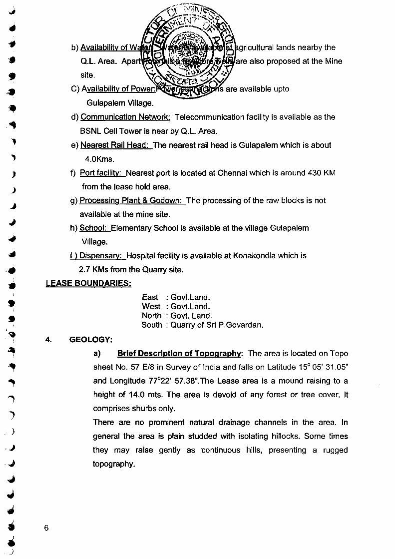
d) Communication Network: Telecommunication facility is available as the
BSNL Cell Tower is near by Q.L. Area.
e) Nearest Rail Head: The nearest rail head is Gulapalem which is about
4.0Kms.
f) Port facility: Nearest port is located at Chennai which is around 430 KM
from the lease hold area.
g) Processing Plant & Godown: The processing of the raw blocks is not
available at the mine site.
h) School: Elementary School is available at the village Gulapalem
Village.
I ) Dispensary: Hospital facility is available at Konakondla which is
2.7 KMs from the Quarry site.
LEASE BOUNDARIES:
4.
6
GEOLOGY:
East : Govt. Land. West : Govt.Land. North : Govt. Land. South : Quarry of Sri P.Govardan.
a) Brief Description of Topography: The area is located on Topo
sheet No. 57 E/8 in Survey of India and falls on Latitude 15° 05' 31.05"
and Longitude 77°22' 57.38".The Lease area is a mound raising to a
height of 14.0 mts. The area is devoid of any forest or tree cover. It
comprises shurbs only.
There are no prominent natural drainage channels in the area. In
general the area is plain studded with isolating hillocks. Some times
they may raise gently as continuous hills, presenting a rugged
topography.

')
)
)
. J
_)
_)
)
b)
Archean
c)
7
are exposed in the the
~ ....... '!..~~sents part of the Archaean Granite
Greenstone terrain of the Dharwar Craton. It has Schistose rocks of
greenstone belts. These are referred to as Archaean greenstone belts.
This has been included by the rocks of Peninsular Gneissic Complex
(PGC) which has gneisses., migamatite and migmatized granite suit of
rocks. Gneisses and migamatites include porphyroblastic hornblende
gneiss, hornblende biotite gneiss, nebulitic to homophenus hornblende
gneiss, pink and green coloured migamatitic gneiss closepet Granite
and its equivalents, namely dolerits porphyritic alkali feldspar granite
and granodiorite, belong to the Proterozoic age have intruded the
above set up. The greenstone belts, gneisses, migamatites and
younger granitoids are intruded by the mafic dyke swarms.
The stratigraphy of the region is given below.
Younger Intrusive
Peninsular Gneissic Complex
Dharwar Super Group
LOCAL GEOLOGY:
Epidote Veins Quartz veins and reefs Veins of alkali feldspar Dolerite/BasaiUGabbro Dykes Biotite Granite
Hornblend granite Biotite granite gneiss Hornblend granite gneiss Porphyritic hornblend granite
Amphibolite, Hornblend schist
The subject area belongs to a hillock raising to a height of about 14.0m
with Sheet rock and boulders from ground level. It is southern slope of
the hill range. However the granite sheet rock is well exposed without
any over burden. It represents late magmatic injection of closepet
granite.

_)
) 8
d)
""""'·.,.,..,..k in the lease area is
medium grained.
::J-==.:....=:..!.:...="-'-=:..:..:::...,=-=-~I#Rtii~~~=e: The rock is Pink colour
with light black shade. The rock is asthatically good looking.
c) Hardness :Moh's Scale : 6 - 7
d)Mineralogical compostion:
Mineralogically the Granite consists of Quartz, Plagioclase feldspar as
essential mineral and other mafics Boitite, Mica, hornblend, etc., as
accessory mineral with fine to medium grain. The Granite available in
the demarcated area is useful for Granite Cutting and Polishing
purpose.
e) Density /specific gravity : 2. 78g/cm 3
f) Water absorption capacity : 0.134%(kg/cm2)
g) Parosity : 0.36
h) Compression strength : 686kg/cm2 (in dry state)
il Abrasiveness : 6 - 7
j) Permeability : Negligible
k) Rock Quality designation : The Rock Quality desigination is
estimated to be good with RQD % between 86and 95.
I) Young modulus of elasticity: 7.729(105 kg/ cm2)
m) Degree of weathering under Hand lense/Microsco~Fresh rock
surface is unweathered and it is categorized as Grade 'A' and there are
some small joints present.
n) Glossiness: The rock takes good polishing.
The Granite available in the demarcated area is useful for
Granite Cutting and Polishing purpose.

,;,:-..
' '
)
, )
~
..J
9
5. EXPLORATION:
a) Present Status & F
The Q.l. area does not contain any forest cover. The area does not
consist any wild life.

.I
')
• ~,
:; )
J
...)
.)
.~:J
5) a) ESTIMATION AND ICAL RESOURCES: Based on the pros""-tllrW"t' nd the present exposure of the
rock, the reserves of the y the following parameters. We have taken 13.0m as pro ~-.._.. able and possible zones In this area the recovery factor is ~~tJ)J~~~~~~1nts and cracks are present in the rock.
Category
Proved
Probable
Possible
10
Influence Sectional Recovery Reserves Rock
Volume wastage Section Distance Area in
in m3 Factor @0.13 in @87% in in m m2 @13% m3 m3
A B (Ax B) 0.13 (A*B)0.13 (A*B)0.87
A-A' 67 572 38324 0.13 4982 33342
B-B' 45 572 25740 0.13 3346 22394
C-C' 67 572 38324 0.13 4982 33342
Sub- Total 13310 89078
A-A' 67 176 11792 0.13 1533 10259
B-B' 45 176 7920 0.13 1030 6890
C-C' 67 176 11792 0.13 1533 10259
Sub-Total 4096 27408
A-A' 67 176 11792 0.13 1533 10259
B-B' 45 176 7920 0.13 1030 6890
C-C' 67 176 11792 0.13 1533 10259
Sub- Total 4096 27408
Grand- Total 21502 143894
Total Colour Granite reserves = 165396m3
The Colour Granite reserves Blocked under buffer Zone = 39690m3
(lxbxh=252x7.5x21) Mineable Colour Granite reserves Salable Colour Granite reserves as 13% R.F
= 125706m3
= 16342m3

\ •
· I
-~ -· :'1
--J ..)
..,;
.J
11
b.
6.
a)
is considered as
1s way a total mineable reserves
lll.....~~~i.J. ~n,~. . area. The production is proposed
to obtain784 m3 per ye . is rate of production, the expected life of
the mine is calculated as given below.
Life of the Quarry:Mineable Reserves/Annual production
=16342/784 = 20.8 years or 21 year.
MINING:
Type of Mining: Open cast method of mining is carried out in this mine
by manually and semi mechanisation by using compressor operated
jack hammer drills, excavators, and dumper etc., Transportation will be
made by trucks to dispatching points. (Rail head/Port)
Brief Description: (Existing method of working)
The mining operations are carried out by semi-mechanisation as open
cast mining. Hydraulic excavator and compresser operated jack
hammers were used for cutting the rock. Close spaced drilling of 0.2m
was adopted along a straight line and charged with low explosives to
avoid feather cracks.

PHOTO SHOWS THE APPLIED Q.L. AREA.
12

)
. _)
c) waste:
next five
be resorted. This material can be utilised to fill the pits after quarry operations
are over. When the dumps reach their optimum height suitable greenery will
be grown on this dumps to stabilize them.
d) Separation of large prima,.Y Blocks from the mother rock by pre-splitting
(Primary cut)
e)
13
The mining will be followed in the form of linear cut method. This involves
loosing of the primary block from mother rock. Hence primary cutting will be
done by line drilling method where close spaced parallel holes along straight
line will be made. Line drilling method is used for separation of primary blocks.
i) Once the free face is developed in working place, the primary cuts is
taken up over a maximum length of 1 0 mtrs with a width of 3 mtrs and
to a depth of 6 mtrs. depends upon the joints availability. These
dimentions are confirmed as for field studies. Primary block will be cut
into secondary blocks by Jackhammer drilling and wedge cutting and
this block will be dislodged from in-situe position by an excavator.
ii) Line drilling method will be used for cutting the primary blocks which
involve drilling and blasting.
iii) The holes are charged with low explosive catridge like gun powder and
non-delay detonators for smooth blasting.
iv) The use of delay detonates causes fragmentation and cracks in rocks.
The non detonating cords are inserted into the holes and the holes are
stemmed with muck and plugged at the mouth and fired.
v) Thus the block will separate from the mother rock, which is pulled off
from the face with cranes or shovel.
Sub Division of large Primary Blocks into Secondary Block:
This will be done drilling close spaced holes (along a line) down to the depth
and the secondary block will be removed easily by just pulling it with the help
of proclain. Close spaced holes will be drilled to the half the length of the block
on either side of it by using wedges blocks can be separated.
f)
primary cut it will be dressed for obtained good geometric shape of granite.
Thus the commercial blocks are produced. ) g} EXTENT OF MECHANISATION:
a. Since it has been decided to undertake semi-mechanized mining
operations,·the following mentioned mine machinery will be deployed.
i. Excavator - One (Bucket capacity 1m3, Boom length, 7m,
Model: Tata Hitachi 200Lc)
ii. 50 CFM- AIR compressors - One
iii. Jack Hammers - three units.
iv. 17 Tonnes Tippers- 3 Nos.
Minor Tools: Chisels, Crowbars, Pick of axes spades and hammers of
different sizes. )
h) Employment Potential: Taking 25 working days in a month, there will )
be 300 working days in a year. The expected output of raw material per
day is about 2 to 3 CBM on an average. Based on the demands from
the purchasers, labour force will be increased.
i) Loading Equipment: Loading of the blocks will be made by chain .. pulley with the help of crane or procline by the skilled labourers to the
hired trucks to transport the material to the nearest ports/ destination of
l customer.
J j) Organisation Chart of the Quarry:
The applicant will appoint following employees at this mine.
1. Mines Manager: Diploma in Mining - with second class Mines
Manager Certificate.
2. Blaster Cum Mate S.S.C. with blaster certificate holder
3. Excavator Operator : 1 No.
4. Compressor Operator: 1 No.
5. Tipper Operators 2 Nos.
6. Drillers 2 Nos.
14

• •
;f) ....
~)
~)
)
" )
_)
J
15
k)
I)
m)
n)
7)
7.
8 .
hammer drills.
utilised during the
Details of Production so far mined from beginning of Quarry.
The production has not been started due to some financial problems of
the lessee .
Labour to be Employed:
Daily 10 members of labours to be employed in this Mines. Drinking
water and first aid facilities were provided in this area.
Quantum of Excavation (08 & Granite):
During this five years operations a total rock mass of 30155m3
will be excavated and 3920 cum of granite Blocks will be recoverable
from this rock mass and remaining material of about 26235m3 will go
as mineral waste.
Scheme Development and Production for the First Five Years Plan
period:
The scheme of development and production for the first five years has
been planned taking into consideration the nature of the deposit within
the lease area.lt is observed that the sheet rock is exposed on Eastern
side (near pit-3) of the Q.L area without any overburden and therefore
the development of the quarry is confined towards Eastern side (near
pit-3)of the Q.L area.The proposed year wise working area is
demarcated on plan and section and it is enclosed as plate no. 4.
a) Year wise Development: There is a vertical and free face is available on
Eastern side (near pit-3)of theQ.L area. So the Eastern side (near pit-3)of the
Q.L area is selected to work for next five years production. It is envisaged to
produce 784m3 of salable granite blocks in each year. To raise this target
production about 6031 m3 of rock mass has to be mined. The site inspection
reveals that the Eastern side (near pit-3)of the Q.L area is suitable for
development during first 5 years programme. Most of this area is covered by
the sheet rock from top to bottom. Year wise quarry development schedule is

•
...
16
nd waste generation details are
ctC'I~~~~~~"' 1ngs will be carried out over a length of
35 mts with Width of 15 mts.The benches will be oriented in North-South
direction and obtained about 784 m3 of granite blocks and 524 7m3 of waste
granite in this year.
2"d year: In second year, the production of granite blocks will be obtained by
advancing the Western side two benches of first year workings towards West
to a distance of 15m without changing the orientation of the benches. In this
year about 784m3 of granite blocks and 5247 m3 of granite waste will
generate.
3rd year: In third year, the production of granite blocks will be obtained by
advancing the Western side two benches of second year workings towards
West to a distance of 15m without changing the orientation of the benches. In
this year about 784m3 of granite blocks and 5247 m3 of granite waste will
generate.
4th year: In fourth year, the production of granite blocks will be obtained by
advancing the Western side two benches of third year workings towards West
to a distance of 15m without changing the orientation of the benches. In this
year about 784m3 of granite blocks and 5247m3 of granite waste will
generate.
5th year: In fifth year, the production of granite blocks will be obtained by
advancing the Western side two benches of fourth year workings towards
West to a distance of 15 m without changing the orientation of the benches. In
this year about 784m3 of granite blocks and 5247 m3 of granite waste will
generate.
During this five years operations a total rock mass of 30155m3 will be
excavated and 3920 cum of granite Blocks will be recoverable from this rock
mass and remaining material of about 26235m3 will go as mineral waste.

r
• J
/ ·· )...:) ' · . ..... ,. R.' .. , ,.-.--r:·. :· ..... 1 '- ~ •, ,.: 2 ~'<w ~ r'·(. ·""' ... ~ . ,.,_.
~· .. '" "' " 11 ....... . " I , .... ••i "' "•
~ """'~ '' ~ f' ......_ _. ,, ' I
~ ll.. tf~ ~ -.. ' ' .
wise aranite oroduct HlJ 0 1 ~~' )./. · ·~~~ -~r~ ~ (3 ~/~~ ..... . _/'r-,0. •. !.¥1 y~ .~J~ ~me Production mJ
Year Working Are _6 R.F . 'rliJ~ m3 Granite Waste .. 35 X 15 = 525 6m 3150 0.13 410 2741
1st year 32 X 15 = 480 6m 2880 0.13 374 2506
784 5247
35 X 15 = 525 6m 3150 0.13 410 2741
2"d year 32 X 15 = 480 6m 2880 0.13 374 2506
784 5247
35 X 15 = 525 6m 3150 0.13 410 2741
3rd year 32 X 15 = 480 6m 2880 0.13 374 2506
784 5247
35 X 15 = 525 6m 3150 0.13 410 2741
4th year 32 X 15 = 480 6m 2880 0.13 374 2506
784 5247
35 X 15 = 525 6m 3150 0.13 410 2741
5th year 32 X 15 = 480 6m 2880 0.13 374 2506
784 5247
3920 26235
b) Ma.gzine:
c)
17
Smooth blasting techniques and special explosives and silent non explosive
demolishing agent like ACCONEX will be used. An area is demarcated within
the lease area for portable magazine. This site is located at a safe distance
from the quarry, strictly adhering to the rules and regulations laid down for
safe storage and handling of the explosives as per the explosives act. The
applicant at the moment is not in possession of blasting license. He will apply
for a licence as and when it is required.
Drilling and Blasting:
Drilling and Blasting plays vital role in determining the size and shape of rough
blocks. Drilling pattern is important in developing a working face and also
preparing the rough blocks suitable for their use in appropriate processing

•
- )
•' 1\
~I
' ) ..._
d)
ii.
iii.
iv.
v.
aces in and around the area,
sures.
oles. 3 meter in case of separation
primary blocks depending on the block size. Then the drill-hole will be
vertical.
Spacing and burden: 1.5 x 3m.
Stemming and charging of the blast hole. The blast hole will be
charged with 100 grams of explosives and filled with clan pills
subsequently, the shot hole will be stemmed.
Explosive type (1) Slurry based explosives or Gun Powder.
e) Broad Blasting Parameter:
Drill-Hole patterns for primary and secondary smooth blasting. Uniform single
line, equidistant holes (line drilling) will be deployed for separation of blocks
from mother rock. In the case of sheet rock the primary drilling will be in the
form of equidistant vertical holes to take out blocks of Gang Saw.
f) Description of Processing plant if any:
There is no any processing plant.
g) Site Services:
It is proposed to provide the site services like Mines office and other statutory
constructions like rest shelter, first aid, workshed and drinking water as
required near the quarry lease. Drinking water will be supplied to the workers
from the borewell opened in the adjacent agricultural field.
Manager's Room 6m x 6m x 3m with ACC roof
Rest Room 6m x 6m x 3m with Sheet roof
Toilets
First Aid
Drinking Water
2m x 1.5m x 3m
Provision is made in the Manager's Room
Provision is made in the Rest Room
h) Market Analysis:
18
The Colour granite has got good textur colour compactnes and
polish taking nature .So it has got good demand in domestic and less in
international market. Although granite is a minor mineral it is a major
contributor in foreign exchange earningsThe lessee has contacted the buyers
•
,, ;;.:,...,
.. , ,;J
~.J
u ""
_)
0
i)
19
colour, polish, price etc.
ortant trade centers. Marketing
different from local market.
on the foreign buyers for both
restrictions imposed by some countries and competition from other countries
that have granite deposites. We have to exploit this growing international
market trend to advantage .The international market is mostly dependent on
the agents of buyers .The buyers imposed restrictions on Quality and on the
sizes. The lessee will stand to face international market demands.
International market is mainly through personalized approach with assurance
of quality and periodical visits to the buyer countries will not only help in
sustaining the clientele, but also enable us to measure up to competition and
assess international market trends. All the above details are well known to the
Lessee and all efforts will be made to face the market trend and demand to
ensure that the venture is a profitable one. The Colour granite is being
marketed lnternationaly and we can expect good market demand will continue
for years to come with improved technology.
Uses of Granite: Granites are most adaptable as interior veneers in sky
scrapers. In architecture, granites are mostly used for artistic veneers as they
enrich other aspects of buildings.
In India granite is used as kitchen platform, kitchen sink, name plates,
foundation/inaugural stones, etc., Granites ashtrays; flower vases and other
art pieces have both domestic and export markets. Other uses for dressed or
cuter shaped forms of different sizes are as flagging stones in the form of flat
slabs or rectangular or irregular shapes over steps, walk ways, parks and
terraces, parking streets and high ways or other traffic areas with rectangular
blocks.
SCHEME OF WASTE MANAGEMENT PLAN (SOLID AND LIQUID):
Solid waste generated year wise for first five years:
Sl. No. Year Total Waste Generated M3
1. 151 Year 5247
2. 2"0 Year 5247

)
j)
k)
8)
3. 3ra Year 5247
4. 5247
5. 5247
26235 ears
Mining operations are carried out on the slopes of the rocky terrain. Hence
there is no water discharge.
Dumping site particulars:
Dumping of waste will be dumped on the area enmarked as shown in plate
No.4. Waste will be stocked over a length of 35 mtrs. Width of 35 mtrs. To a
height of 21.44 mtrs., in the S-W side of the area. During the first five years
about 26235 m3 of waste material will be generated.
Estimated Waste Quantity that will be generated over the entire period:
Total Colour granite reserves =125706m3
Colour granite available in the format = 13%
Colour granite reserves = 125706 x 0.13 = 16342m3
Total Mineral waste in the area = 87%
= 125706 x 0.87 = 109364m3
ENVIRONMENTAL MANAGEMENT PLAN:
The area granted is covered by rocky out crops and bushy thorny vegetation.
There are no agricultural lands in the area.
a) Baseline Information :
i) Land use pattern : The Quarry area belongs to the Government and it is
not being used for any other use except for grazing.
ii) Flora and Fauna : The subject area is rocky terrain and does not consists
any trees or major vegetation except the presence of reptiles and other minor
wild life like rabbits, field rats etc., no major wild life exists in this area.
iii) Climate Conditions : The peak summer will be in the month of May. Highest
temperature of 41° C is recorded in the area during the month of May and the
Lowest temperature of 19° C is recorded in the month of January, 2012.
During 2010-2011 the rainfall of the area was of about 570mm.
iv) Quality of water, air and Ambient Noise Level : The Subject area is away
from Industries and Human settlements at present. So the air and water are
20
v)
vi) Human Settlement : The following villages are within 5Km radius in the
applied area. The population, distance and location of these villages with
respect to Applied Area are given in the following table.
S.No Name of the Village Population Distance Direction
(Km)
1 Gulapalem 750 1.0 S-W
2 Konakondla 1300 2.7 N-W
3 Kamalapadu 870 4.1 S-E
VII) Public Buildings, Places of Worship and Monuments: There are no public
Buildings, Places of Worship and Monuments within or near the area.
VIII) Whether the area falls under the notified area of water act. 197 4 : No
b) ENVIRONMENTAL IMPACT ASSESSMENT (NEXT FIVE YEARS)
I) Land degradation: An extent of about 2625 m2 area will be sliced down
during first five years to a depth of 12 mtrs.
II) Water quality : There are no chances for changes in quality of surface water
or ground water the quarry operations will be carried out on slope of the rocky
terrain.
iii) Quality of Air : The area is surrounded by Agricultural lands and there are
no industries nearby. Hence natural air is available in this area. There are
chances for air pollution at the time of jackhammer drilling and at the time
transportation of Mineral and Waste. But this air pollution will be controlled to
the ambient air quality standards (253 hours) i.e., S02= 120ug/m3, N02 =
120ug/m3, Suspended Particulate Mater (SPM) =500UG/m3, Respirable
Particulate Mater size < 1 Oum) (RPM) = 150ug/m3, CO= 5mg/m3 by keeping
dust collector at the jackhammer drilling site. The mine roads will be sprayed
with water, before starting the transportation of Mineral and Wastes to
minimise air pollution.
21
'

. I
,.) f"'.
··,' "'-·
:.:..) ...
~
vii)
viii)
C)
i)
the area, and therefore their~t!~~~~~~~
ENVIRONMENTAL MANAGEMENT PLAN :
nor the general surface
Proposals for Reclamation of Land Effected by mining : Care will be taken
to see that the mining operations in this area do not have any negative inpact
on the environment Reclamation and rehabilitation of the lands affected by
mining will done by back filling, soil ANELIORA TION and afforestation. This
will be taken up on need basis before the conclusion of mining operations.
The back filling of the mine starts from the Eastern end proceeds towards
Western side. Drainage will be developed along the slopes of the Mound.
Reclamation of the effected land includes back filling, Drainage development ,
spreading and fertilization of soil, levelling and revegetation etc. Care will be
taken to implement the said factors.
ii) Storage and Utilisation of Topsoil : The waste consisting of topsoil in this
area is dumped in the stock yard.
iii) Measure to control to Erosion/Sedimentation Water course : There are
not be any erosion/sedimentation in the area, because, there will not be any
water discharge from mine workings.
iv) Stabilization and vegetation of Dumps: About 26235m3 of waste material
will be generated during this plan period. This waste will be dumped on South
Western side of the area to height of 21.44m and dumps will be stabilized by
the pack wall.
v) Treatment and Disposal of water from Mine : No water will be discharged
from the mine.
vi) Measures for Projection of Historical Monuments and Rehabilitation of
Human Settlements likely to be disturbed due to Mining Activity : Does
not arise.
vii) Measures for Ground Vibrations due to Blasting : Minimum blasting will be
opted during mining. Sound due to blasts will be kept low which is not an
environmental hazard. Smooth blasting techniques and special explosives
and silent non - explosive demolishing Agent like ACCONEX will be used.
23
Muffed blasting and use
noise pollution.
viii) Socio Economic be""o~litt..\WI"'-"Ii'i«ft . : Few labours will get
employment and the royalty and sales tax due to
mining and selling of the gran l~~~~
ix) Afforestation: In every year about 50 mtrs. length of buffer zone will be
planted along the boundaries on Northern, Southern and Western side of the
area. About 33 Saplings consisting of Neem, Teak will be planted per year
over an area of 50m x 6m at 3m grid interval. Year wise plantation area is
shown in Plate No.4 ' 11) Any other Relevant information:
• Ecological relationship viz. Selanization of water and surface material is
not effected.
• Aesthitic and human interests like scenic views and vistas, wilderness
qualities, landscape qualities are not effected.
• Biological conditions like trees, crops, grass are not effected.
• Fauna, though insignificant will not be generated.
Enclosures:
Location - cum - Key Plan Plate - 1
Lease sketch Plate - 2
Surface Geological plan Plate - 3
Geological section Plate - 3A
Year wise working plan and sections Plate - 4
Environmental Plan Plate - 5
fnature of the R Q P
( P.Veeran Goud )
Prepared by: P.Veerana Goud
Reg.No.RQP/DMG/HYD/ 060/2002
)e CJ,/;o&f~o}pev Signature of theApplicant.
P.PlJLLAl~"~· l)epu~J Director of Mines and Giro~
_ Kt.JR.NOOL.
7) The Grantee should submit in the 1st year and Mining Plan within two years from the date of execution of the quarry lease deed failing which the lease will be cancelled without giving any opportunity. He should submit an ttnder taking to that effect to the Asst. Director of Mines and Geology, Anantapur before executing the lease deed.
Note: The grant is liable for cancellation should it be found that it was grossly Inequitable or was made under a mistake of fact or owin~ to misrepresentation or fraud or in excess of authority.
Encl:- (Appendix) Sd/-V.D.RAJA GOPAL.
DIRECTOR OF MINES AND GEOLOGY
~, riRECTOR OF MINES AND GEOLOGY
1) Sri U.Anjaneyulu, S/o.U.Pedda PEddanna, D.No.l3-189, Karapuram Road (BYRPAD), Valmiki NAgar, Gunta kal,Anantapur District.
2) Copy to the Zonal Joint Director of Mines and Geology, Kadapa. 3) Copy to the Assistant Director of Mines and Geology, Anantapur along with File.No.
195/Q 1/PG/09. 4) Copy to Stock File.
Fm. 7.28.4.2009.
---------
. '

,
· }
)
A PRADESH ~~~~AAJf~Jc!n'h D GEOLOGY
JES AND GEOLOGY:: ANANTAPUR. , B.Sc., Asst. Director)
DATE: 22-06-2009
Sub: Mines and Quarries - Minor Minerals - Quarry Lease for Colour ,Gr-anite over an extent of 1.000 Hect. in Sy. No: 187 of Gulapa!ern (V), Vajrakarur (M), Anantapur District - For a period of twe.nty years in favour of Sri U. Anjaneyulu - Quarry Lease Deed executed - Work Order -Issued.
Ref: 1) Procs. No: 2074/R4-1/09, Dated: 24-04-2009 of the Director of Mines and Geology, Hyderabad.
2) Lr. No: 195/Q2/CG/09, Dt: 14-05-2009 of the Assistant Director of Mines and Geology1 Anantapt:tr.
:3) Letter dt: 20-05-09 from Sri U. Anjaneyulu.
**'*** ORDER:
Through the reference 1 .:t cited 1 the Director of Mines and Geology, Hyderabad has granted a Quarry Lease for Colour Granite over an extent of 1.000 Hect. in Sy. No: 187 of Gulapalem (V), Vajarkarur (M), Anantapur District for a period of twenty years in favour of Sri U. Anjaneyulu under Rule 12 (5) (a) (i) of APMMC Rules, 1966.
Through the reference 2nd cited this office has requested the gr-antee to attend for execution of the subject Quarry Lease Deed cilong with required documents within the stipulated period. Accordingly through'fhe reference 3rd
cited the grantee has attended this office duly submitting all the required documents and requested to execute the Quarry Lease Deed today i.e. 22.06.2009.
Further the Quarry Lease Deed is executed today i.e. 22-06:-2009 in favour of Sri U. Anjaneyulu for Colour Granite over the subject area for a period of 20 years with effect from 22-06-2009 to 21-06-2029.
The lessee is hereby permitted to commence the Quarrying operations for Black Granite in the subject area as per G.C.D.R.1999 e ... APMMC Rules 1966 and the rules to be amended from time to time. The lessee should produce invariably all the accoun-ts, registersr documents, records etc. 1 in connection with the subject lease held by 5th April of every y·eat"''before trse Asst.! Director of Mines and Geology, Anantapur. The lessee should submit the Quarteriy returns in Form 'F'1 and Annual return in Form "G" to the Director of Mines and Geology! Hyderabad 1 to the Deputy Director of Mines and Geology, Kurnool and to the Assistant Director of Mines and Geology, Anantapur as required under Rule 41 of G.C.D.R.1999. The lessee should send report in Form 'F' to the Chief Inspector of Mines Safety, Dhanbad and to the Asst., Director of Mines and Geology, Anantapur as required under Rule 30 of APMMC Ru!es, 1966.
[P.T.O]
, .. ,': .....
• , :. i I . . . ... ' .
' • I
. ~ .... . . ;~· \) \ ;\ -: •' ,• I~ ,. \i
- 2 - . . ~ l • 'l . • ,,.~,~ ~ -., !
Fprther the lessee"- ·ip· ·hereby ' '-r~qu~§te~.· )o submit the scherne of prospecting report in t 'he · l-6
: · year. aiQl .. 'f.:lfihog Plan within two years: from the date of execution of Ql'raJty Le~ed failing which the lease will be cancelled without giving any o~p6.{twi1\!y :-~ 'l)er G.O.Ms.No.186 Industries 8: Commerce {M.I) Department, datect: ' 3(}.:.04-2002 and the condition imJ)Osed in the grant order. The lessee has furnished an undertaking to that effect as direCted in the grant order.
The lessee should obtain the dispatch permits from the Assista nt r irc.c..tor of Mines and Geology; Anantapur before transporting tl1e material from the leased area . The lessee should abide the conditions contained in the Anne.xure appended to the Grant order scrupulously.
To,
Asst. Director o~nd Geology, Anantapur.
\.../sri U. Anja_n~yulu, S/o Sri U. Pedda Pedd~nn~, D. No: 13-189, Kasapurarr: · Road, Valm1k1 Nagar, Guntakal, Anantapur D1stnct
Co py submitted to:
l11e Director of Mines & Geology, Hyderabad along with Quarry Lease deed for favour of in formation . ( 0 2. sets)
·n,e .~onal Joint Direc~or of Mines & Geology, Kadapa for favour of infor·mation ..
l11e Dy. Director of Mines & Geology, Kurnool along with Quarry Lease deed for· favour of information.
The Dy. Director of 1\-lines ~~Safety, Bellary for favour of information.
l11e, Dist Collector, Anantapur for favour of information.
l11e Controller General, IBM, Nagapur for favour of information.
Copy to the Labour Enforcement Officer (Central), Qr.No.533, Opp: Railway High School, Guntakal - 515 801 for favour of information.
Copy to the Tahsildar, Vajrakaru r ( M) for favour of infor·mation.
Copy to the Sarpanch, Gram Panchayat, Gulapa!em {V) for information.
' •
\ ) . ' )
I'
)-
)
)
)
)
_)

')
Dated:24-4-2009.
Sub:- Mines and Quarries - Quarry Lease for Colour Granite over an extent of 1.000 Hectares, in S.No.187 of Gulapalem Village, Vajrakarur Mandai, Anantapur District - infavour of Sri U.AnjaneyuLu Granted - Orders -issued -Regarding. l
Ref:- 1. Quarry Lease application Dt.6.1.2009 from Sri U.Anjaneylulu. 2. ADM&G, Anantapur File.No.l95/Ql/PG/09, dt. 25.2.2009.
******* <zi:.. . \....- ~ \l)) ~,...:~ '\':;)
L ~ Through the reference 131 cited Sri U.Anjaneyulu has applied for grant of quarry \)~' \ lease fot colour Granite over an extent of 1.000 Hectares in S.No.187 of Gulapalem
Village, Vajrakaru Mandai, Anantapur District for a period of 20 years with relevant ~~<1i documents. The said Quarry Lease application is received by the Assistant Director
of Mines and Geology, Anantapur on 15.1.2009.
Through the reference znd cited the Assistant Director of Mines and Geology, Anantapur has reported that the topographically the applied area is hillock with a height of about 25 mts from ground level. The granite available in the area in light to red in colour and it is hard and compact and fine to medium grained. The rock is useful for cutting and polishing purpose.
Further the Assistant Director of Mines and Geology, Anantapur has reported that S.No.187 of Gulapalem Village, Vajrakarur Mandai, Anantapur District is Government 'land. After Survey and demarcation, the Area has comes to 1.000 Hectares. The applicant has given consent to the extent and signed on the surveyed sketch.
The Tahsildar Vajrakar has issued No Objection Certificate vide LR.No.13/140/2008 dt. 20.1.2009 for grant of quarry lease over an extent of l.OOO Hectares in S.No. 187 of Gulapalem Village, Vajrakarur Mandai, Anantapur District in favour of Sri V .Anjanyelu. The land in S.No.l87 is classified as konda.
The applicant has submitted an affidavit stating that he does not possess any QUPUML under the Provisions of Andhra Pradesh Minor ,Mineral Concession Rules 1966 and Mining Concession Rules 1960.
Finally, the Assistant Director of Mines and Geology, Anantapur has recommended for grant of quarry lease for Colour Granite over an extent of 1.000 hectares in S.No. 187 of Gulapalem Village, Vajrakarur Mandai, Anantapur District in favour of Sri U.Anjaneyulu for a period of 20 years.
Further the Zonal Joint Director of Mines and Geology, Kadapa has also proposed for grant of quarry lease as recommended by the Assistant Director of Mines and Geology, Anantapur in favour of Sri U.Anjaneyulu.
\.nnt 2.

4)
,,. ) . . ,r :
', . .'1/211 ' '
1n view of tl1c above c.ircull\~t~w.es, qua}ty lease for Colour' Granite over ,..:_; ex tent of .lQQQ.._Hetiar...es._in 8.1~~1~.~ of. Gulapalem Villa~e) VaJrakarur Mandai, J' Anantapur District is here_by gran edin ~~~our of.Sri. U .~'!-j~ey(}~u ,fo~ a period of 20 years under rule 12(5)(a)(l) of Andhra J?ra(;!esh ¥mor Mtpera,l C~ncess10n Ru'iesT%6 subject to the fo llowing conditions, conditions..inentiqneg,.i-rt.the appendix enclosed to this order, other terms and copditions undl~ Qran1te 'Cob'serv'ation and Development Rules, 1999 and subsequent G.overnment order and executive instructions issued thereupon from time to time.
1. The Grantee shall pay the following amoup.ts before execution of the Quarry lease deed:
i) Dead Rent : Rs.40,000/- per hectare per annum. ii) Land Assessment: s per the rates prescribed by the Revenue Authorities. iv) Security Deposit: A sum equal ant to one year dead rent. iii) Cess on Land Assessment: At the rate of Rs.0.25 Paisa per rupee on
Land Assessment. v) Cess on Land Hold:: Rs.25/- Per Cub. Mt. on Granite.
2) The grantee shall execute the lease deed in From "G" within (60) days from the date of grant as per Rule 12(5) (e) of Andhra Pradesh Minor Mineral concession Rules, 1966.
3) The grantee shall pay Seigniorage fee in advance as detailed below and dispatch the granite under a valid dispatch permit and transit forms issued by the Asst. Director of Mines and Geology concerned
More than 270 em X 150 em in size
Rs.1750/-
Below 270 em X150 em size
Rs.1500/-
Below 75 em in size
Rs.750/- ·
The grantee shall pay the dead rent, Land Assessment and Cess on Land Assessment one month in advance i.e., before 151 March of every year during the subsistence of the lease period regularly whether formally demanded and called for or not.
5) The grantee shall pay Seigniorage Fee as per the rates prc;:scribed from time to time under schedule-! in advance for the quantity intended to be dispatched and then only dispatch the material under the dispatch the material w1der the dispatch permit and transit forms obtained from the Asst. Director of Mines and Geology, concemed. The Granteesball furnish details of dispatches immediately soon after the dispatches of material as per Rules 12(5.(h)(iii) of Andhra Pradesh Minor Mineral Concession Rules, 1966.
6)(a) The grantee should pay Seigniorage fee or deed rent which ever is higher on the minerals dispatched or consumed from the land at the rates specified under schedule-! and II as the case may be in accordance with Rule 10(1) of Andhra Pradesh Minor Miner~.t! Concession Rules, 1966.
6)(b) The Government may, during the currency of the lease, vary the rate of deed rent and Seigniorage fee and the grantee is liable to bear pay and discharge all existing and future rates, taxes, assessments etc., what so ever imposed or charged as per orders of the Government.
(. I
~-
(l
( )
~)
c! ~ ~ ,_..)
"' /~ ._) (" _)
(' .)

-~-,
..:~
·~
CERTIFICATE OF RENEWAL OF REGISTRATION AS QUALIFIED PERSON TO PREPARE MINING PLAN
UNDER RULE 14(3) OF GRANITE CONSERVATION AND DEVELOPMENT RULES 1999
* * * * * SRI. P. Veeran Goud, 5/o. Late P.Basavan Goud, R/o. 4-261-2,
Kalyanadurg Road, Behind Raja Hotel, Anantapur is hereby granted
renewal of recognition under Rule 14(3) of the Granite Conservation
and Development Rules 1999 for further period as a Qualified person
to prepare Mining Plans.
Registration Number is: j RQP I DMG I HYD I 060 I 2002

13 12 11 10 90
80 X
INDEX ITIJ ASSUMED BENCH MARK
m LEASE BOUNDARY
J--:::::::1 CONTOUR
l....YI PIT
-~ROAD I D I BUFFER ZONE
~ SECTION LINE
Jvvv I SOIL COVER
~COLOUR GRANITE
D DUMPYARD
c
, , , , , ,
, , , , , .. , ,
A- OFFICE B -FIRST AID ROOM C -STORE ROOM D -REST SHED E- TOILETS
Working Plantation
~ lstYEAR ~
~ 2ndYEAR ~
D 3 rdYEAR D I. - I 4 th YEAR D B SthYEAR ~
lCM=lOM
-Pp. VEERAN G
y
90 80
GEOLOGIS RQP / DMG/HYD/060/2007 PLATE-4
MINING PLAN FOR COLOUR GRANITE IN S.No.187 of Gulapalem (V), Vajrakarur (M)
Anantapur Dist. Extent: 1.000 Hectare.
5 YEARS WORKING PLAN
Sri U.Anjaneyulu, S/o Sri U.Pedda Peddanna, D.No: 13-189, Kasapuram Road, Valmiki Nagar, Guntakal, Anantapur District.
SCALE : 1:1000 CONTOUR INTERVAL-3.0 M

INDEX [QJ ASSUMED BENCH MARK
~ LEASE BOUNDARY
1--::::1 CONTOUR
1........-1 PIT
j ,~::-:1 ROAD
I D I BUFFER ZONE
~ SECTION LINE
lvvv I SOIL COVER
~:COLOUR GRANITE
D DUMPYARD
1CM=10M
P.VEERAN GEOLOGIST M.Sc.,
RQP / DMG/HYD/060/200:>
A
PLATE-3 MINING PLAN FOR COLOUR GRANITE
IN S.No.187 of Gulapalem (V), Vajrakarur (M) Anantapur Dist. Extent: 1.000 Hectare.
SURFACE GEOLOGICAL SCHEME Sri U.Anjaneyulu, S/o Sri U.Pedda Peddan~a, D.No: 13-189,
Kasapuram Road, Valmiki Nagar, Guntakal, Anantapur District .
SCALE : 1:1000 CONTOUR INTERVAL-3.0 M

I
I
I
I
I
I
'
'
I
I
, ,
, ,
, , , ,
, , ,
, ,
,
vvvvvv
vvvvvv v v v v
DRY -L:AI'J [!
v v v v v y
vvvvvv v v v v
I GRAZING LAND
\
\
\
vvvvvv
vvvvvv v v v v
\ GRAZING LAND
' ' ' ' ' ' ' ' ' ' ' ' ' ' ...
.vvvvvv
vvvvvv
~~:N~ v v v v
v v v
vvvvvv v v v v
FJR¥~l:AND
vvvvvv
VYVVVV
v v v v
.....,'---------'
INDEX ASSUMED BENCH MARK LEASE BOUNDARY CONTOURS
\..___,/ I PIT ~ IROAD
ULTIVATION LAND OM BUFFER ZONE
SOOM BUFFER ZONE
Pu. C2 ~J P. VEERAN dUD
GEOLOGIST M.Sc,
RQP./ DMG / HYD/060/200/
BJl¥~t.AND
- - - - - -
~ 5_,Le98jl~ev 1 • P1Si.rciNr
...
... ... ... '
' ... '
vvvvvv
vvvvvv
v v v v
' ' ... ... ' ' ' ' '
'
. .
; ~
GRAZING LAND
vvvvvv
vvvvvv
v v v v
vv. vvvv
VVVVYV
v v v v
' \ \
\
\
\
\
\
vvvvvv '
VYVVVV \
v v v y
GRAZING LAND I
I
I
I
I
I
, , D·RY~ttAND
, , , vvvvvv ,
, vvvvvv ,
v v v v , , , ,
, , , ,
lAPPROVED .
' MINING PLAN FOR COLOUR GRANITE IN S.No.187 of Gulapalem (V), Vajrakarur (M)
Anantapur Dist. Extent: 1.000 Hectare.
ENVIRONMENT PLAN
Sri U.Anjaneyulu, S/o Sri U.Pedda Peddanna, D.No: 13-189, Kasapuram Road, Valmiki Nagar, Guntakal,
Anantapur District. SCALE : 1:5000 CONTOUR INTERVAL-3.0 M