ASX: GAL DEFINED AT EMPIRE ROSE PROSPECT - Galileo Mining
12
Page 1 | 12 30 October 2018 ASX: GAL Corporate Directory Directors Non-Executive Chairman Simon Jenkins Managing Director Brad Underwood Technical Director Noel O’Brien Fast Facts Issued Capital 120.4m Share Price $0.175 Market Cap $21.1m Cash (30/09/18) $10.1m Projects Norseman Cobalt Project Fraser Range Nickel Project Contact Details T: +61 8 9463 0063 E: [email protected] W: www.galileomining.com.au NEW FRASER RANGE TARGET DEFINED AT EMPIRE ROSE PROSPECT Highlights • Anomalous nickel assays from shallow aircore drilling at the Empire Rose prospect in the Fraser Range: o 36m @ 0.20% Nickel from 18m (drill hole EARC015) Including 3m @ 0.56% Nickel from 24m o 6m @ 0.19% Nickel from 30m (drill hole EARC046) • Mafic-ultramafic host rocks indicate potential for mineralisation • Strong geophysical conductor identified in prospective structural location relative to drilling results • Follow up geophysical survey is planned to further refine targets prior to additional drilling Galileo Mining Ltd (ASX: GAL, “Galileo” or the “Company”) is pleased to announce first pass aircore drilling at the Empire Rose prospect in the Fraser Range has identified anomalous zones of nickel in mafic and ultramafic rocks similar to the rock units that occur at the Nova and Silver Knight deposits. Although the initial results are not of economic grade, the presence of a strong conductive response identified in an EM geophysical survey indicates the possibility of sulphide mineralisation at depth. A follow up IP geophysical survey is planned to refine targets prior to further drill testing. Galileo Managing Director, Brad Underwood, said the first drilling results from Galileo’s Fraser Range Nickel Project were highly encouraging and with new targets identified the Company is hopeful that a discovery could eventuate. “The Empire Rose prospect is the first area Galileo has drilled within its Fraser Range project portfolio. To have such positive results in our first drilling program is a great outcome and we hope that additional work, both at Empire Rose and at our other Fraser Range prospects, leads to the discovery of economic resources. “The drilling at Empire Rose has intersected an extensive ultramafic peridotite sill of the kind often associated with nickel deposits around the world including the deposits so far found in the Fraser Range. The EM conductor is offset and down dip of the better nickel results while the occurrence of a granulite pyroxenite lens to the south west of the conductor adds extra support to the deeper target. “The Fraser Range is a rapidly evolving new mineralised province and with two confirmed discoveries in the area we believe that the potential for further discoveries is high. “We will be actively exploring our tenements and we already have follow-up work programs planned for the Empire Rose prospect as well as first pass drilling programs planned at our northern Nightmarch and Lantern prospects”.
Transcript of ASX: GAL DEFINED AT EMPIRE ROSE PROSPECT - Galileo Mining

Page 1 | 12
30 October 2018 ASX: GAL
Corporate Directory Directors Non-Executive Chairman Simon Jenkins Managing Director Brad Underwood Technical Director Noel O’Brien Fast Facts Issued Capital 120.4m Share Price $0.175 Market Cap $21.1m Cash (30/09/18) $10.1m Projects Norseman Cobalt Project Fraser Range Nickel Project Contact Details
T: +61 8 9463 0063 E: [email protected] W: www.galileomining.com.au
NEW FRASER RANGE TARGET DEFINED AT EMPIRE ROSE
PROSPECT
Highlights
• Anomalous nickel assays from shallow aircore drilling at the Empire Rose prospect in the Fraser Range:
o 36m @ 0.20% Nickel from 18m (drill hole EARC015) Including 3m @ 0.56% Nickel from 24m
o 6m @ 0.19% Nickel from 30m (drill hole EARC046) • Mafic-ultramafic host rocks indicate potential for mineralisation • Strong geophysical conductor identified in prospective structural
location relative to drilling results • Follow up geophysical survey is planned to further refine targets
prior to additional drilling
Galileo Mining Ltd (ASX: GAL, “Galileo” or the “Company”) is pleased to announce first pass aircore drilling at the Empire Rose prospect in the Fraser Range has identified anomalous zones of nickel in mafic and ultramafic rocks similar to the rock units that occur at the Nova and Silver Knight deposits. Although the initial results are not of economic grade, the presence of a strong conductive response identified in an EM geophysical survey indicates the possibility of sulphide mineralisation at depth. A follow up IP geophysical survey is planned to refine targets prior to further drill testing. Galileo Managing Director, Brad Underwood, said the first drilling results from Galileo’s Fraser Range Nickel Project were highly encouraging and with new targets identified the Company is hopeful that a discovery could eventuate. “The Empire Rose prospect is the first area Galileo has drilled within its Fraser Range project portfolio. To have such positive results in our first drilling program is a great outcome and we hope that additional work, both at Empire Rose and at our other Fraser Range prospects, leads to the discovery of economic resources.
“The drilling at Empire Rose has intersected an extensive ultramafic peridotite sill of the kind often associated with nickel deposits around the world including the deposits so far found in the Fraser Range.
The EM conductor is offset and down dip of the better nickel results while the occurrence of a granulite pyroxenite lens to the south west of the conductor adds extra support to the deeper target.
“The Fraser Range is a rapidly evolving new mineralised province and with two confirmed discoveries in the area we believe that the potential for further discoveries is high.
“We will be actively exploring our tenements and we already have follow-up work programs planned for the Empire Rose prospect as well as first pass drilling programs planned at our northern Nightmarch and Lantern prospects”.
Page 2 | 12
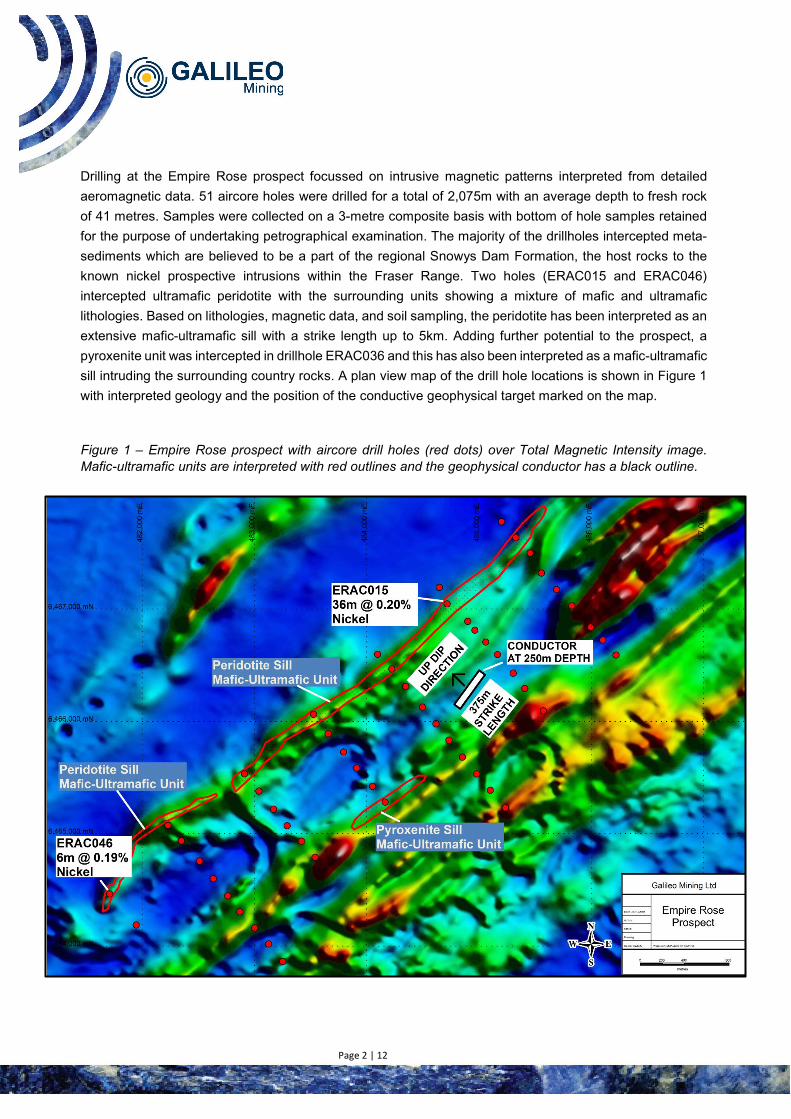
Drilling at the Empire Rose prospect focussed on intrusive magnetic patterns interpreted from detailed aeromagnetic data. 51 aircore holes were drilled for a total of 2,075m with an average depth to fresh rock of 41 metres. Samples were collected on a 3-metre composite basis with bottom of hole samples retained for the purpose of undertaking petrographical examination. The majority of the drillholes intercepted meta-sediments which are believed to be a part of the regional Snowys Dam Formation, the host rocks to the known nickel prospective intrusions within the Fraser Range. Two holes (ERAC015 and ERAC046) intercepted ultramafic peridotite with the surrounding units showing a mixture of mafic and ultramafic lithologies. Based on lithologies, magnetic data, and soil sampling, the peridotite has been interpreted as an extensive mafic-ultramafic sill with a strike length up to 5km. Adding further potential to the prospect, a pyroxenite unit was intercepted in drillhole ERAC036 and this has also been interpreted as a mafic-ultramafic sill intruding the surrounding country rocks. A plan view map of the drill hole locations is shown in Figure 1 with interpreted geology and the position of the conductive geophysical target marked on the map.
Figure 1 – Empire Rose prospect with aircore drill holes (red dots) over Total Magnetic Intensity image. Mafic-ultramafic units are interpreted with red outlines and the geophysical conductor has a black outline.

Page 3 | 12
Significant intercepts from the aircore drilling are shown in Table 1 below. Nickel assays are indicative of mafic-ultramafic rock units that have the potential to host accumulations of nickel-copper-cobalt sulphides similar to the Nova and Silver Knight deposits in the Fraser Range. While no significant sulphides have yet been identified at the Empire Rose prospect it is understood that the existence of mafic-ultramafic lithologies are a necessary feature of nickel deposits in the Fraser Range and that their occurrence at the Empire Rose prospect is a positive development.
Table 1: Empire Rose Prospect Significant Results, 0.09% Nickel lower cut
Hole_ID Prospect From (m) To (m) Interval Ni% Fe% Mg% Cr%
ERAC015 Empire Rose 18 54 36 0.20 4.54 5.99 0.05
including 24 27 3 0.56 5.77 1.96 0.04
ERAC046 Empire Rose 30 36 6 0.19 13.82 1.17 0.14 Based on 3 metre composite sample assay results, 0.09% Nickel lower cut
An electromagnetic survey undertaken at the Empire Rose prospect, designed to look for conductive rocks that might represent accumulations of nickel and copper sulphides, has identified a strong conductor down dip and offset from the high nickel values intercepted at the bedrock interface within the ultramafic unit. Interpretation of the geophysical data by Spinifex Gpx indicates that the anomaly has a strong late time response (implying a high conductivity) and has been modelled as a bedrock conductor with a restricted strike length. The conductive response was visible in two of the survey lines and did not extend beyond into the remainder of the surveyed lines on either side of the conductor. The top of the conductor is modelled at 257 metres depth, has a strike length of 375 metres, and extends at least 200 metres sub vertically with a dip of 710. The modelled conductivity is 2,100 siemens, a value within the range typically associated with sulphides.
Petrography samples sent for thin section analyses have confirmed the ultramafic rocks within drillholes ERAC015 and ERAC046 as serpentinised peridotites. Drillhole EARC036 intersected an ultramafic pyroxenite at the bottom of hole with associated mafic material up hole. The petrographic description of this rock suggested a cumulus origin with potential for magmatic nickel-copper in the unit. The pyroxenite has been interpreted as a mafic-ultramafic sill and is approximately 1km southwest of the conductor. The existence of this unit implies that other mafic-ultramafic rocks may have intruded into the prospect area at depths below the penetration capability of the initial aircore drilling.
An Induced Polarisation (IP) geophysical survey will be completed at Empire Rose prior to the start of deeper drilling. The IP survey will help to refine potentially mineralised targets prior to the commencement of relatively expensive deep drilling. Once the IP survey is complete it is anticipated that an RC drilling program of 1,000 -1,500 metres, followed by diamond drilling of approximately 500 metres, would be logical next steps to advance the prospect.
Galileo has two Joint Ventures with the Creasy Group covering 492 km2 of granted exploration licenses in the Fraser Range region of Western Australia. The tenements are prospective for magmatic nickel-copper-cobalt mineralization similar to that discovered at Nova and at Silver Knight. The presence of two significant discoveries in the Fraser Range indicates that the area is a developing mineral province and that new

Page 4 | 12
discoveries may be forthcoming in the future. Figure 2 shows the location of Galileo’s prospects and tenements in the Fraser Range, with respect to the Nova and Silver Knight deposits, and to other key tenement holders in the region.
Figure 2 – Galileo’s Fraser Range tenement holdings (blue) with Empire Rose, Nightmarch and Lantern prospect locations as marked. Silver Knight and Nova deposits are shown by mine symbols.

Page 5 | 12
Cut-off Co, ppm
Class Tonnes Mt
Co Ni Mn % % Kt % Kt
MT THIRSTY SILL 600 Indicated 10.5 0.12 12.1 0.58 60.8 0.71
Inferred 2.0 0.11 2.2 0.51 10.2 0.71 Total 12.5 0.11 14.3 0.57 71.1 0.71
1,000 Indicated 5.2 0.15 8.0 0.64 32.9 1.01 Inferred 0.8 0.15 1.2 0.52 4.1 1.09 Total 6.0 0.15 9.2 0.62 37.0 1.02
MISSION SILL 600 Inferred 7.7 0.11 8.2 0.45 35.0 0.80
1,000 Inferred 2.8 0.15 4.4 0.47 13.4 1.20 TOTAL JORC COMPLIANT RESOURCES
600 20.2 0.11 22.5 0.53 106.1 0.74 1,000 8.8 0.15 13.6 0.57 50.4 1.08
Competent Person Statement
The information in this report that relates to Exploration Results is based on information compiled by Mr Brad Underwood, a Member of the Australasian Institute of Mining and Metallurgy, and a full time employee of Galileo Mining Ltd. Mr Underwood has sufficient experience that is relevant to the styles of mineralisation and types of deposit under consideration, and to the activity being undertaken, to qualify as a Competent Person as defined in the 2012 Edition of the “Australasian Code for Reporting of Exploration Results, Mineral Resources and Ore Reserves” (JORC Code). Mr Underwood consents to the inclusion in the report of the matters based on his information in the form and context in which it appears.
Investor information: phone Galileo Mining on + 61 8 9463 0063 or email [email protected]
Media: David Tasker Managing Director Chapter One Advisors E: [email protected] T: +61 433 112 936 About Galileo Mining: Galileo Mining Ltd (ASX: GAL) is focussed on the exploration and development of cobalt and nickel resources in Western Australia. GAL holds tenements near Norseman with over 22,000 tonnes of contained cobalt, and 106,000 tonnes of contained nickel, in JORC compliant resources (see Figure 3 below). GAL also has Joint Ventures with the Creasy Group over tenements in the Fraser Range which are prospective for nickel-copper-cobalt deposits.
Figure 3: JORC Mineral Resource Estimates for the Norseman Cobalt Project (“Estimates”) (refer to ASX “Prospectus” announcement dated May 25th 2018 and accessible at http://www.galileomining.com.au/investors/asx-announcements/). Galileo confirms that all material assumptions and technical parameters underpinning the Estimates continue to apply and have not materially changed).

Page 6 | 12
Appendix 1: Empire Rose (Fraser Range) Drill Hole Collar Locations
Hole ID Prospect East North RL Dip Azimuth Depth
ERAC001 Empire Rose 482912 6465534 395 -90 Vertical 63 ERAC002 Empire Rose 483040 6465379 392 -90 Vertical 36 ERAC003 Empire Rose 483170 6465219 403 -90 Vertical 46 ERAC004 Empire Rose 483291 6465072 398 -90 Vertical 54 ERAC005 Empire Rose 485200 6467778 363 -90 Vertical 22 ERAC006 Empire Rose 485328 6467636 359 -90 Vertical 34 ERAC007 Empire Rose 485455 6467499 370 -90 Vertical 33 ERAC008 Empire Rose 485556 6467321 365 -90 Vertical 48 ERAC009 Empire Rose 485689 6467175 369 -90 Vertical 35 ERAC010 Empire Rose 485827 6467029 369 -90 Vertical 18 ERAC011 Empire Rose 485994 6466839 376 -90 Vertical 30 ERAC012 Empire Rose 486102 6466724 345 -90 Vertical 17 ERAC013 Empire Rose 486220 6466591 382 -90 Vertical 60 ERAC014 Empire Rose 484647 6467193 369 -90 Vertical 20 ERAC015 Empire Rose 484776 6467047 381 -90 Vertical 54 ERAC016 Empire Rose 484899 6466891 376 -90 Vertical 24 ERAC017 Empire Rose 484963 6466813 365 -90 Vertical 38 ERAC018 Empire Rose 485060 6466707 380 -90 Vertical 42 ERAC019 Empire Rose 485164 6466595 376 -90 Vertical 24 ERAC020 Empire Rose 485304 6466429 382 -90 Vertical 35 ERAC021 Empire Rose 485407 6466293 386 -90 Vertical 46 ERAC022 Empire Rose 485572 6466095 385 -90 Vertical 42 ERAC023 Empire Rose 484098 6466598 376 -90 Vertical 35 ERAC024 Empire Rose 484223 6466467 391 -90 Vertical 32 ERAC025 Empire Rose 484347 6466312 385 -90 Vertical 21 ERAC026 Empire Rose 484496 6466127 383 -90 Vertical 37 ERAC027 Empire Rose 484616 6465979 393 -90 Vertical 34 ERAC028 Empire Rose 484732 6465833 404 -90 Vertical 48 ERAC029 Empire Rose 484852 6465682 413 -90 Vertical 63 ERAC030 Empire Rose 484979 6465533 403 -90 Vertical 46 ERAC031 Empire Rose 485100 6465387 390 -90 Vertical 48 ERAC032 Empire Rose 485236 6465231 404 -90 Vertical 30 ERAC033 Empire Rose 483794 6465729 394 -90 Vertical 36 ERAC034 Empire Rose 483912 6465586 389 -90 Vertical 41 ERAC035 Empire Rose 484052 6465423 398 -90 Vertical 50 ERAC036 Empire Rose 484164 6465282 401 -90 Vertical 56 ERAC037 Empire Rose 482231 6465075 394 -90 Vertical 39 ERAC038 Empire Rose 482350 6464937 401 -90 Vertical 42 ERAC039 Empire Rose 482511 6464757 398 -90 Vertical 29 ERAC040 Empire Rose 482634 6464601 404 -90 Vertical 12 ERAC041 Empire Rose 482762 6464448 386 -90 Vertical 53 ERAC042 Empire Rose 482871 6464306 201 -90 Vertical 38 ERAC043 Empire Rose 483003 6464163 397 -90 Vertical 35 ERAC044 Empire Rose 483127 6464019 399 -90 Vertical 34 ERAC045 Empire Rose 483253 6463863 398 -90 Vertical 82 ERAC046 Empire Rose 481712 6464465 384 -90 Vertical 36 ERAC047 Empire Rose 481948 6464188 378 -90 Vertical 81 ERAC048 Empire Rose 483528 6466063 374 -90 Vertical 48 ERAC049 Empire Rose 483656 6465892 395 -90 Vertical 28 ERAC050 Empire Rose 483541 6464791 396 -90 Vertical 54 ERAC051 Empire Rose 483420 6464934 413 -90 Vertical 66
Easting and Northing coordinates are in GDA94 zone 51.

Page 7 | 12
Appendix 2: Galileo Mining Ltd – Fraser Range Project
JORC Code, 2012 Edition – Table 1 Section 1 Sampling Techniques and Data (Criteria in this section apply to all succeeding sections.)
Criteria JORC Code explanation Commentary
Sampling techniques
• Nature and quality of sampling (eg cut channels, random chips, or specific specialised industry standard measurement tools appropriate to the minerals under investigation, such as down hole gamma sondes, or handheld XRF instruments, etc). These examples should not be taken as limiting the broad meaning of sampling.
• Include reference to measures taken to ensure sample representivity and the appropriate calibration of any measurement tools or systems used.
• Aspects of the determination of mineralisation that are Material to the Public Report.
• In cases where ‘industry standard’ work has been done this would be relatively simple (eg ‘reverse circulation drilling was used to obtain 1 m samples from which 3 kg was pulverised to produce a 30 g charge for fire assay’). In other cases more explanation may be required, such as where there is coarse gold that has inherent sampling problems. Unusual commodities or mineralisation types (eg submarine nodules) may warrant disclosure of detailed information.
• Reverse Circulation (RC) drilling, was used to obtain one metre samples which were ground dumped in rows.
• Each one metre sample pile was spear sampled to obtain a representative 3 metre composite sample for analyses.
• QAQC standards (blank & reference) and duplicate samples were included routinely with 1 per 20 samples being a standard or duplicate.
• Samples were sent to an independent commercial assay laboratory.
• All assay sample preparation comprised oven drying, jaw crushing, pulverising and splitting to a representative assay charge pulp.
• A 25g pulped sample charge was digested using Aqua Regia (AR25/MS33) and ICP-MS was used to determine a 33 element suite: Au, Ag, Al, As, B, Ba, Bi, Ca, Cd, Ce, Co, Cr, Cu, Fe, K, La, Mg, Mn, Mo, Na, Ni, P, Pb, S, Sb, Sc, Sr, Te, Ti, Tl, V, W, Zn.
• An additional single metre sample of the last metre (EOH) drilled in each hole was spear sampled to obtain a representative sample for analyses.
• A 50g pulped sample charge from the EOH sample was assayed by Fire Assay, ICP-MS determination (FA50/MS) for Au, Pt, Pd.
• A 1g pulped sample charge was digested using Four Acid (4A/MS48) was used for a 48 element analysis suite: Ag, Al, As, Ba, Be, Bi, Ca, Cd, Ce, Co, Cr, Cs, Cu, Fe, Ga, Ge, Hf, In, K, La, Li, Mg, Mn, Mo, Na, Nb, Ni, P, Pb, Rb, Re, S, Sb, Sc, Se, Sn, Sr, Ta, Te, Th, Ti, Tl, U, V, W, Y, Zn, Zr by ICP-MS.
Drilling techniques
• Drill type (eg core, reverse circulation, open-hole hammer, rotary air blast, auger, Bangka, sonic, etc) and details (eg core diameter, triple or standard tube, depth of diamond tails, face-sampling bit or other type, whether core is oriented and if so, by what method, etc).
• RC drilling was undertaken using a 5 ½ “drill bit completed by Red Rock Drilling Pty Ltd. An RC blade Bit was used for most of the drilling with RC hammer utilised to ensure penetration to recognisable lithology of weakly

Page 8 | 12
Criteria JORC Code explanation Commentary
oxidised to fresh rock at end of hole as determined by the geologist supervising the drilling.
Drill sample recovery
• Method of recording and assessing core and chip sample recoveries and results assessed.
• Measures taken to maximise sample recovery and ensure representative nature of the samples.
• Whether a relationship exists between sample recovery and grade and whether sample bias may have occurred due to preferential loss/gain of fine/coarse material.
• Sample recoveries are visually estimated for each metre with poor or wet samples recorded in drill and sample log sheets for both single metres and composite intervals.
• The sample cyclone was routinely cleaned at the end of each 6m rod, between holes and when deemed necessary.
• No relationship has been determined between sample recoveries and grade and there is insufficient data to determine if there is a sample bias.
Logging • Whether core and chip samples have been geologically and geotechnically logged to a level of detail to support appropriate Mineral Resource estimation, mining studies and metallurgical studies.
• Whether logging is qualitative or quantitative in nature. Core (or costean, channel, etc) photography.
• The total length and percentage of the relevant intersections logged.
• Geological logging of drill holes was done on a visual preliminary basis with full logging in progress to include lithology, grainsize, mineralogy, colour and weathering.
• Logging of drill chips is qualitative and based on the presentation of the 1m samples in the chip trays.
• All drill holes were logged in their entirety
Sub-sampling techniques and sample preparation
• If core, whether cut or sawn and whether quarter, half or all core taken.
• If non-core, whether riffled, tube sampled, rotary split, etc and whether sampled wet or dry.
• For all sample types, the nature, quality and appropriateness of the sample preparation technique.
• Quality control procedures adopted for all sub-sampling stages to maximise representivity of samples.
• Measures taken to ensure that the sampling is representative of the in situ material collected, including for instance results for field duplicate/second-half sampling.
• Whether sample sizes are appropriate to the grain size of the material being sampled.
• All RC drill samples were collected using a PVC spear as 3m composites (2-3kg). Other composites of 2m and 4m and individual 1m samples were collected where required ie, at the bottom of hole.
• The samples were dried and pulverised before analysis.
• QAQC reference samples and duplicates were routinely submitted with each batch.
• The sample size is considered appropriate for the mineralisation style, application and analytical techniques used.
Quality of assay data and laboratory tests
• The nature, quality and appropriateness of the assaying and laboratory procedures used and whether the technique is considered partial or total.
• For geophysical tools, spectrometers, handheld XRF instruments, etc, the parameters used in determining the analysis including instrument make and model, reading times, calibrations factors applied and their derivation, etc.
• Nature of quality control procedures adopted (eg standards, blanks, duplicates, external
• RC Chip composite samples were analysed for a multielement suite (33 elements) by ICP-MS following an Aqua Regia digest.
• EOH RC Chip samples were analysed for a multielement suite (48 elements) by ICP-MS following a Four Acid Digest as well as for Au, Pt, Pd by Fire Assay with ICP-MS determination.
• The assay methods used are considered appropriate.

Page 9 | 12
Criteria JORC Code explanation Commentary
laboratory checks) and whether acceptable levels of accuracy (ie lack of bias) and precision have been established.
• QAQC standards and duplicates were routinely included at a rate of 1 per 20 samples
• Further internal laboratory QAQC procedures included internal batch standards and blanks
• Sample preparation was completed at Intertek Genalysis Laboratory, (Kalgoorlie) with digest and assay conducted by Intertek-Genalysis Laboratory Services (Perth).
Verification of sampling and assaying
• The verification of significant intersections by either independent or alternative company personnel.
• The use of twinned holes. • Documentation of primary data, data entry
procedures, data verification, data storage (physical and electronic) protocols.
• Discuss any adjustment to assay data.
• Field data is collected on site using a standard set of logging templates entered directly into a laptop. Data is then sent to the Galileo database manager (CSA Global - Perth) for validation and upload into the database.
• Assays are as reported from the laboratory and stored in the Company database and have not been adjusted in any way.
Location of data points
• Accuracy and quality of surveys used to locate drill holes (collar and down-hole surveys), trenches, mine workings and other locations used in Mineral Resource estimation.
• Specification of the grid system used. • Quality and adequacy of topographic control.
• Drill hole collars are surveyed with a handheld GPS with an accuracy of +/-5m which is considered sufficient for drill hole location accuracy.
• Co-ordinates are in MGA94 datum, Zone 51.
• Topographic control has an accuracy of 2m based on detailed satellite imagery derived DTM.
Data spacing and distribution
• Data spacing for reporting of Exploration Results.
• Whether the data spacing and distribution is sufficient to establish the degree of geological and grade continuity appropriate for the Mineral Resource and Ore Reserve estimation procedure(s) and classifications applied.
• Whether sample compositing has been applied.
• Drill hole spacing for the individual drill holes was grid based and first pass in nature, the holes being placed to provide a systematic pattern coverage of the geological domain/target area of interest.
• Drill spacing has been spaced on an 800m x 200m grid pattern. This spacing has been deemed adequate for first pass assessment only and is not considered sufficient to determine JORC Compliant Inferred Resources and therefore additional drilling would be required.
• Drill holes were sampled on a 3m composite basis or as 1m or 2m samples at the end of hole as required. Where anomalous values are returned, 1m samples may be submitted for assay.
Orientation of data in relation to
• Whether the orientation of sampling achieves unbiased sampling of possible structures and the extent to which this is known, considering the deposit type.
• It is unknown whether the orientation of sampling achieves unbiased sampling of possible structures as the mineralisation is hosted in soft regolith

Page 10 | 12
Criteria JORC Code explanation Commentary
geological structure
• If the relationship between the drilling orientation and the orientation of key mineralised structures is considered to have introduced a sampling bias, this should be assessed and reported if material.
material with no measurable structures recorded in drill core.
• The mineralisation occurs in highly weathered regolith material and no structures have been recorded from drilling.
• No quantitative measurements of mineralised zones/structures exist and all drill intercepts are reported as down hole length, true width unknown.
Sample security
• The measures taken to ensure sample security. • Each sample was put into a tied off calico bag and then several placed in a large plastic “polyweave” bag which was zip tied closed. For transport, sampled were placed on wooden pallets inside plastic “polyweave” “Bulk Bags” ensuring no loss of material.
• Samples were delivered directly to the laboratory in Kalgoorlie by Galileo’s freight contractor.
Audits or reviews
• The results of any audits or reviews of sampling techniques and data.
• Continuous improvement reviews of sampling techniques and procedures are ongoing. No external audits have been performed.
Section 2 Reporting of Exploration Results (Criteria listed in the preceding section also apply to this section.)
Criteria JORC Code explanation Commentary
Mineral tenement and land tenure status
• Type, reference name/number, location and ownership including agreements or material issues with third parties such as joint ventures, partnerships, overriding royalties, native title interests, historical sites, wilderness or national park and environmental settings.
• The security of the tenure held at the time of reporting along with any known impediments to obtaining a licence to operate in the area.
• The Fraser Range Project comprises four granted exploration licenses, covering 492km2
• Kitchener JV tenement E28/2064 (67% NSZ Resources Pty Ltd, 33% Great Southern Nickel Pty Ltd).
• Yardilla JV tenements: E63/1539, E63/1623, E63/1624 (67% FSZ Resources Pty Ltd, 33% Dunstan Holdings Pty Ltd)
• NSZ Resources Pty Ltd & FSZ Resources Pty Ltd are wholly owned subsidiaries of Galileo Mining Ltd.
• Great Southern Nickel Pty Ltd and Dunstan Holdings Pty Ltd are entities of Mark Creasy
• The Kitchener Area is approximately 250km east of Kalgoorlie on vacant crown land and on the Boonderoo Pastoral Station.
• The Yardilla Area is approximately 90km east of Norseman on vacant crown land and on the Fraser Range Pastoral Station.
• Both the Kitchener Area and the Yardilla Area are 100% covered by the Ngadju Native Title Determined Claim.
• The tenements are in good standing and there are no known impediments.

Page 11 | 12
Criteria JORC Code explanation Commentary
Exploration done by other parties
• Acknowledgment and appraisal of exploration by other parties.
• NA
Geology • Deposit type, geological setting and style of mineralisation.
• The target geology is magmatic sulphide mineralisation hosted in mafic-ultramafic intrusions within the Fraser Complex of the Albany-Fraser Orogeny.
• The underlying unweathered lithology is granulite facies metamorphosed and partially retrogressed sedimentary and mafic and ultramafic igneous rocks as determined by petrographic work.
Drill hole Information
• A summary of all information material to the understanding of the exploration results including a tabulation of the following information for all Material drill holes: o easting and northing of the drill
hole collar o elevation or RL (Reduced Level
– elevation above sea level in metres) of the drill hole collar
o dip and azimuth of the hole o down hole length and
interception depth o hole length.
• If the exclusion of this information is justified on the basis that the information is not Material and this exclusion does not detract from the understanding of the report, the Competent Person should clearly explain why this is the case.
• Refer to drill hole collar and intercept reporting table in the body of the report
Data aggregation methods
• In reporting Exploration Results, weighting averaging techniques, maximum and/or minimum grade truncations (eg cutting of high grades) and cut-off grades are usually Material and should be stated.
• Where aggregate intercepts incorporate short lengths of high grade results and longer lengths of low grade results, the procedure used for such aggregation should be stated and some typical examples of such aggregations should be shown in detail.
• The assumptions used for any reporting of metal equivalent values should be clearly stated.
• Weighted averaging has been used, based on the sample interval, for the reporting of drilling results.
• Aggregation procedures are described in the footnotes to the drill hole intercept table in the body of the report.
Relationship between
• These relationships are particularly important in the reporting of
• It is unknown whether the orientation of sampling achieves unbiased sampling of possible structures

Page 12 | 12
Criteria JORC Code explanation Commentary
mineralisation widths and intercept lengths
Exploration Results. • If the geometry of the
mineralisation with respect to the drill hole angle is known, its nature should be reported.
• If it is not known and only the down hole lengths are reported, there should be a clear statement to this effect (eg ‘down hole length, true width not known’).
as the mineralisation is hosted in soft regolith material with no measurable structures recorded in drill core.
• The mineralisation occurs in highly weathered regolith material and no structures have been recorded from drilling.
• No quantitative measurements of mineralised zones/structures exist, and all drill intercepts are reported as down hole length, true width unknown.
Diagrams • Appropriate maps and sections (with scales) and tabulations of intercepts should be included for any discovery being reported These should include, but not be limited to a plan view of drill hole collar locations and appropriate sectional views.
• Project location map and plan map of the drill hole locations with respect to each other and with respect to other available data. Drill hole locations have been determined with hand-held GPS drill hole collar location (Garmin GPS 78s) +/- 5m in X/Y/Z dimensions
Balanced reporting
• Where comprehensive reporting of all Exploration Results is not practicable, representative reporting of both low and high grades and/or widths should be practiced to avoid misleading reporting of Exploration Results.
• All available relevant information is presented.
Other substantive exploration data
• Other exploration data, if meaningful and material, should be reported including (but not limited to): geological observations; geophysical survey results; geochemical survey results; bulk samples – size and method of treatment; metallurgical test results; bulk density, groundwater, geotechnical and rock characteristics; potential deleterious or contaminating substances.
• Detailed 50m line spaced aeromagnetic data has been used for interpretation of underlying geology. Data was collected using a Geometrics G-823 Caesium vapor magnetometer at an average flying height of 30m.
• Moving Loop Electromagnetic (MLEM) survey data was collected on 400m loops using a Smartem V system and Jesse Deeps SQUID receiver in a 400m offset Slingram configuration collecting Z, X and Y component data at a base frequency of 1Hz.
• Maxwell software was utilised to process and model the MLEM data.
• Modelling and interpretation of geophysical data was undertaken by Spinifex Gpx Pty Ltd
• Petrography was undertaken by R.N. England Consulting Geologist
Further work • The nature and scale of planned further work (eg tests for lateral extensions or depth extensions or large-scale step-out drilling).
• Diagrams clearly highlighting the areas of possible extensions, including the main geological interpretations and future drilling areas, provided this information is not commercially sensitive.
• Dipole-Dipole IP surveying is planned at the Empire Rose Prospect aimed at further constraining the modelled MLEM conductor area as well as identify possible disseminated sulphide associated targets with the main ultramafic unit which strikes NE along the western side of the Empire Rose Prospect.


![UNLIMITED FIRE DESIGN · 2019. 7. 16. · 15.5 L [US] 4.0 gal / [UK] 3.3 gal 24.0 L [US] 6.34 gal / [UK] 5.28 gal 24.0 L [US] 6.34 gal / [UK] 5.28 gal 24.0 L [US] 6.34 gal / [UK]](https://static.fdocuments.net/doc/165x107/60cd4b6e3e1e6e269d46acb8/unlimited-fire-design-2019-7-16-155-l-us-40-gal-uk-33-gal-240-l-us.jpg)