
ASX ANNOUNCEMENT th For personal use only
17
ASX ANNOUNCEMENT 25 th Nov 2021 Barracuda PGE-Ni-Cu Project exploration update. Carnavale Resources Limited (ASX: CAV) is pleased to provide an exploration update on the Barracuda Platinum-Palladium-Nickel-Copper (PGE-Ni-Cu) Project (granted license E58/551) located 60km east of the gold mining town of Mt Magnet in the Murchison district of Western Australia. The Barracuda Project (48km 2 ) is in the fertile Windimurra mafic ultramafic layered igneous complex. Highlights • Detailed helicopter borne geophysical survey Versatile Time Domain Electro Magnetic (VTEM Max) to commence next week. • Multiple co-incident platinum and palladium geochemical anomalies defined by Pancontinental Mining Ltd (Pancon) soil sampling program with a strike length of over 4km. • Broad spaced Aerial RepTEM imagery shows conductive layers parallel to geology. • PGE-sulphide minerals identified by WA Geological Survey within the Project area 1 . • Only 1,811m of drilling ever completed by Pancon, and no drilling since 1988. 5 • No ground electromagnetic (‘EM’) or Induced Polarisation (‘IP’) geophysical surveys ever conducted. CAV has contracted UTS Geophysics Pty Ltd to fly the latest airborne EM technology (VTEM -Max) helicopter borne geophysics with the aim of identifying concealed conductors that could host PGE-Ni-Cu mineralisation. The VTEM Max system is excellent for locating discrete conductive anomalies as well as mapping lateral and vertical variations in resistivity. When conductive anomalies are present, it is possible to identify drill targets directly from the airborne results. The survey will be flown at 200m line spacing with the EM sensor at 35m for 266-line kilometres. This system provides the highest signal/noise ratio and spatial resolution of conductors. Heli VTEM has successfully defined basement mineralisation for ASX listed Pursuit Minerals Ltd at their Warrior Project adjacent to Chalice Mining Ltd’s Julimar deposit. The Julimar deposit was discovered using 200m spaced ground EM geophysics. CEO Humphrey Hale commented: “We have compiled the graphical data from early Pancon reports into our digital database and have integrated this information with recently acquired remote sensing data. The geochemistry, geophysics and geology of the tenement area supports CAV’s exploration model that the Barracuda Project has the potential to host significant PGE-Ni-Cu sulphide mineralisation similar to the Julimar Project discovered by Chalice Mining Ltd. CAV has committed to fly VTEM technology over the tenement area to search for concealed PGE-Ni-Cu mineralisation. This detailed survey will be able to see further than ever before, beneath the surface to detect conductive sulphide bodies.” For personal use only
Transcript of ASX ANNOUNCEMENT th For personal use only

ASX ANNOUNCEMENT 25th Nov 2021
Barracuda PGE-Ni-Cu Project exploration update.
Carnavale Resources Limited (ASX: CAV) is pleased to provide an exploration update on the Barracuda
Platinum-Palladium-Nickel-Copper (PGE-Ni-Cu) Project (granted license E58/551) located 60km east of
the gold mining town of Mt Magnet in the Murchison district of Western Australia. The Barracuda Project
(48km2) is in the fertile Windimurra mafic ultramafic layered igneous complex.
Highlights
• Detailed helicopter borne geophysical survey Versatile Time Domain Electro Magnetic (VTEM
Max) to commence next week.
• Multiple co-incident platinum and palladium geochemical anomalies defined by Pancontinental
Mining Ltd (Pancon) soil sampling program with a strike length of over 4km.
• Broad spaced Aerial RepTEM imagery shows conductive layers parallel to geology.
• PGE-sulphide minerals identified by WA Geological Survey within the Project area1.
• Only 1,811m of drilling ever completed by Pancon, and no drilling since 1988.5
• No ground electromagnetic (‘EM’) or Induced Polarisation (‘IP’) geophysical surveys ever
conducted.
CAV has contracted UTS Geophysics Pty Ltd to fly the latest airborne EM technology (VTEM -Max)
helicopter borne geophysics with the aim of identifying concealed conductors that could host PGE-Ni-Cu
mineralisation.
The VTEM Max system is excellent for locating discrete conductive anomalies as well as mapping lateral
and vertical variations in resistivity. When conductive anomalies are present, it is possible to identify drill
targets directly from the airborne results. The survey will be flown at 200m line spacing with the EM sensor
at 35m for 266-line kilometres. This system provides the highest signal/noise ratio and spatial resolution
of conductors.
Heli VTEM has successfully defined basement mineralisation for ASX listed Pursuit Minerals Ltd at their
Warrior Project adjacent to Chalice Mining Ltd’s Julimar deposit. The Julimar deposit was discovered
using 200m spaced ground EM geophysics.
CEO Humphrey Hale commented:
“We have compiled the graphical data from early Pancon reports into our digital database and have
integrated this information with recently acquired remote sensing data. The geochemistry, geophysics and
geology of the tenement area supports CAV’s exploration model that the Barracuda Project has the
potential to host significant PGE-Ni-Cu sulphide mineralisation similar to the Julimar Project discovered by
Chalice Mining Ltd. CAV has committed to fly VTEM technology over the tenement area to search for
concealed PGE-Ni-Cu mineralisation. This detailed survey will be able to see further than ever before,
beneath the surface to detect conductive sulphide bodies.”
For
per
sona
l use
onl
y

2
Barracuda Ni Cu PGE Project (Project)
Outcropping PGE mineralisation assaying 8.27g/t 3PGE was discovered by Pancon in 1987 on the contact
between mafic and olivine-rich ultramafic rocks. In 2016, PGE-sulphide minerals were identified in the
rocks by the Western Australia Geological Survey. CAV completed a sampling program and reported up
to 3.45g/t 4PGE in rock chips expanding on and confirming the earlier Pancon results. See CAV ASX
release 6th April 2021.
Figure 1: Location of the Barracuda PGE-Ni-Cu Project Area (E58/551)
This highly prospective area has the potential to host substantial magmatic, mafic-ultramafic intrusion-
related PGE-Ni-Cu sulphide deposits and has received no attention since Pancon drilled 1,811m of
diamond and shallow (<100m) RC holes in 19886.
Geology
The Project lies on the northwestern edge of the Windimurra igneous complex (WIC). The WIC, described
as the largest exposed single layered igneous intrusion in Australia, has been the focus of multiple field
trips and research by the GSWA and the GSA, because of correlations with the Bushveld Igneous Complex
(BIC) in South Africa and the potential for similar economic Ti-V and PGE-Ni-Cr-Cu mineralisation. The
BIC represents about 75 percent of the world's platinum and about 50 percent of the world's palladium
resources8.
For
per
sona
l use
onl
y

3
Figure 2: CAV tenement with relation to the structure and geology of the WIC
Prospectivity of the Barracuda Project Area
Exploration by Pancon in the late 1980’s delineated outcropping magmatic PGE-Cr-Ni-Cu mineralisation
within the current Barracuda project area that demonstrates that the WIC has created mineralised zones
and supports the potential for mineralisation at depth.
There are a number of references in geological research papers that provide an indication of the PGE-Cr-
Ni-Cu prospectivity of the Project. Ivanic et al. 2017 provided a comparative summary of the WIC and the
BIC showing great similarities (Table 1).
The 3D modelling (Ivanic and Brett, 2015) highlights the possibility that a significant Ultramafic Zone, up
to 3 km thick, a target for economic PGE-Ni–Cr–Cu mineralization could underlie the whole of the eastern
lobe of the WIC. The Ultramafic Zone probably extended to the surface around most of the complex prior
to deformation.
Contiguous parts of the Ultramafic Zone are modelled to be within 500 m of the surface along its north-
western margins, which underlays the project area (Figure 2). Horizons with high impedance contrasts
within this zone identified by seismic data may indicate similar lithological characteristics to the Critical
Zone of the BIC.
The detailed helicopter borne VTEM Max survey is targeting this style of concealed sulphide mineralisation
at depth.
For
per
sona
l use
onl
y

4
Table 1: WIC compared to BIC that hosts extensive economic mineralisation
Figure 3: RepTEM imagery showing EM response within tenement area aligned with Geology.
For
per
sona
l use
onl
y

5
The RepTEM aerial EM geophysical survey was flown in 2008 on 400m line spacing as part of a large-
scale regional survey. Geophysical, remote sensing EM technology has improved significantly since 2008.
The hotter colours within the RepTEM imagery (Figure 3) show more conductive elements. There appear
to be stronger conductors in the southern portion of the tenement area that are not covered by the Pancon
soil program and represent possible targets to be enhanced by the upcoming VTEM Max survey.
It is notable that there are conductive bands within the tenement package, aligned with the geology, that
can be identified in the imagery from the wide spaced regional RepTEM survey (Figure 3), even though
the RepTEM technology was flawed, and the data skewed by the strong response from saline ground
water in the surrounding areas. CAV believes that this enhances the prospectivity of the tenement area.
Upon importing the Pancon soil data into the CAV digital database CAV has contoured the Pancon soil
anomaly data for platinum and palladium in figures 4 and 5. These anomalies align with the mapped
geology and is conformable with the RepTEM imagery as shown in figure 4.
Figure 4: Platinum in soils over magnetics Figure 5: Palladium in soils over magnetics
Historical Exploration
Pancon held exploration licenses over most of the Windimurra Igneous Complex between 1985 and 1990
and targeted magmatic PGE-Ni-Cu sulphide mineralisation. Their exploration culminated in the discovery
of outcropping magmatic PGE-Cr-Ni-Cu mineralisation in October 19874 within the Project area.
Pancon initially conducted geological mapping and drainage sampling to identify and delineate PGE
anomalous catchments and favourable geology. These areas were then followed-up with traverses of
For
per
sona
l use
onl
y
6
close-spaced (10m) soil sampling (-80 mesh) on lines 200m to 800m apart. This soil assay data (Cu, Ni,
Pt, Pd) was only ever presented graphically (analogue) as stacked line profiles 6. CAV has rebuilt the digital
assay tables from the Pancon diagrams enabling advanced data manipulation and reinterpretation. It is
likely to identify new drill targets when interpreted in conjunction with results from the upcoming VTEM
survey data.
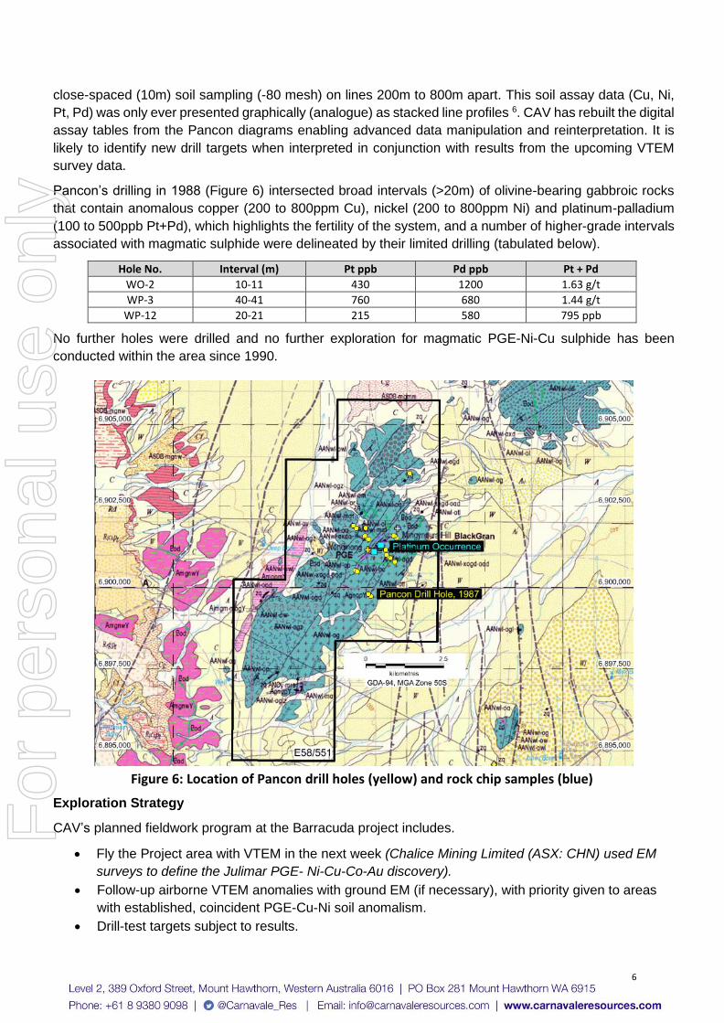
Pancon’s drilling in 1988 (Figure 6) intersected broad intervals (>20m) of olivine-bearing gabbroic rocks
that contain anomalous copper (200 to 800ppm Cu), nickel (200 to 800ppm Ni) and platinum-palladium
(100 to 500ppb Pt+Pd), which highlights the fertility of the system, and a number of higher-grade intervals
associated with magmatic sulphide were delineated by their limited drilling (tabulated below).
Hole No. Interval (m) Pt ppb Pd ppb Pt + Pd
WO-2 10-11 430 1200 1.63 g/t
WP-3 40-41 760 680 1.44 g/t
WP-12 20-21 215 580 795 ppb
No further holes were drilled and no further exploration for magmatic PGE-Ni-Cu sulphide has been
conducted within the area since 1990.
Figure 6: Location of Pancon drill holes (yellow) and rock chip samples (blue)
Exploration Strategy
CAV’s planned fieldwork program at the Barracuda project includes.
• Fly the Project area with VTEM in the next week (Chalice Mining Limited (ASX: CHN) used EM
surveys to define the Julimar PGE- Ni-Cu-Co-Au discovery).
• Follow-up airborne VTEM anomalies with ground EM (if necessary), with priority given to areas
with established, coincident PGE-Cu-Ni soil anomalism.
• Drill-test targets subject to results.
For
per
sona
l use
onl
y

7
This release is approved by the Board of Carnavale Resources Limited.
For further information contact: Ron Gajewski Humphrey Hale Chairman CEO P: +61 8 9380 9098 Competent Persons Statement
The information that relates to Exploration Results for the projects discussed in this announcement
represents a fair and accurate representation of the available data and studies; and is based on, and
fairly represents information and supporting documentation reviewed by Mr. Humphrey Hale, a
Competent Person who is a Member of The Australian Institute of Geoscientists. Mr. Hale is the Chief
Executive Officer of Carnavale Resources Limited and has sufficient experience that is relevant to the
style of mineralisation and type of deposit under consideration and to the activity being undertaken to
qualify as a Competent Person as defined in the 2012 Edition of the “Australasian Code for Reporting
of Exploration Results, Mineral Resource and Ore Reserves”. Mr. Hale consents to the inclusion in this
report of the matters based on his information in the form and context in which it appears.
Forward Looking Statements
Statements regarding Carnavale’s plans with respect to the mineral properties, resource reviews,
programs, economic studies and future development are forward-looking statements. There can be no
assurance that Carnavale’s plans for development of its mineral properties will proceed any time in the
future. There can also be no assurance that Carnavale will be able to confirm the presence of additional
mineral resources/reserves, that any mineralisation will prove to be economic or that a mine will
successfully be developed on any of Carnavale’s mineral properties.
Information relating to Previous Disclosure
Previous CAV ASX releases
Carnavale to acquire the Barracuda PGE-Ni-Cu Project in Western Australia and Placement to raise
$2.22M - 11 March 2021
Up to 3.45g/t 4PGE* in rock chips from Barracuda PGE-Ni-Cu Project initial field trip – 6th April 2021
References
BARNES, S.J., HILL, R.E.T., (Eds.) 1991. Mafic-Ultramafic Complexes of Western Australia, Sixth
International Platinum Symposium Excursion Guidebook No. 3. Geological Society of Australia (W.A.
Division). 1Ivanic, TJ 2016, A field guide to the mafic–ultramafic intrusions of the Youanmi Terrane, Yilgarn Craton:
Geological Survey of Western Australia, Record 2016/6, 61p.
Ivanic, TJ and Brett, J 2015, The Windimurra Igneous Complex, Yilgarn Craton: an Archean layered
intrusion revealed by seismic data and 3D modelling: Geological Survey of Western Australia, Record
2015/12, 28p.
Ivanic TJ, Wingate MTD, Kirkland CL, Van Kranendonk MJ and Wyche, S 2010, Age and significance of
voluminous mafic–ultramafic magmatic events in the Murchison Domain, Yilgarn Craton, Australian
Journal of Earth Sciences, 57:5, 597-614. 2 IVANIC, T.J., WINGATE, M.T.D., KIRKLAND, C.L., VAN KRANENDONK, M.J., WYCHE, S. 2010. Age
and significance of voluminous mafic-ultramafic magmatic events in the Murchison Domain, Yilgarn
Craton. Australian Journal of Earth Sciences 57, 597-614. 8R. P. SCHOUWSTRA and E. D. KINLOCH (2000). A Short Geological Review of the Bushveld Complex
(PDF). Platinum Metals Review. 44 (1): 33–39
For
per
sona
l use
onl
y

8
Pancontinental Mining Ltd. reports 3 WAMEX A21081, First Annual Report Windimurra Project June 1986 to June 1987. Company Report 4 WAMEX A23847, Second Annual Report Windimurra Project June 1987 to June 1988. Company Report 5 WAMEX A28015, Third Annual Report Windimurra Project June 1988 to June 1989. Company Report 6 WAMEX A33863, Fourth Annual Report Windimurra Project June 1989 to June 1990. Company Report 7 WAMEX reports can be viewed on the Department of Mines, Industry Regulation and Safety website and
at the following address https://www.dmp.wa.gov.au/Geological-Survey/Mineral-exploration-
Reports-1401.aspx
For
per
sona
l use
onl
y

9
Table 1. Holes drilled by Pancontinental Mining Limited 1988 (WAMEX A280156)
Hole No. Hole Type
East GDA-94
z50
North GDA-94
z50 Grid East
Grid North
Angle (deg)
Azimuth (mag)
Depth (m)
WO-1 Diamond 633771 6901478 14600 19230 -55 310 210
WO-2 Diamond 634192 6901259 14700 18766 -55 310 98
WO-3 Diamond 634465 6900904 14600 18330 -55 310 174
WO-4 Diamond 634320 6901154 14700 18601 -55 310 165
WO-5 Diamond 633370 6901809 14600 19750 -55 310 34
WO-6 Diamond 633274 6901889 14600 19875 -55 310 110
WO-7 Diamond 633652 6901576 14600 19385 -55 310 89
WP-1 RC Perc 634611 6900783 14600 18140 -55 310 51
WP-2 RC Perc 634624 6901551 15200 18620 -55 310 65
WP-3 RC Perc 634662 6901519 15200 18570 -55 310 63
WP-4 RC Perc 634601 6901570 15200 18650 -55 310 60
WP-5 RC Perc 633794 6899771 13300 18125 -55 310 62
WP-6 RC Perc 633840 6899733 13300 18065 -55 310 63
WP-7 RC Perc 633755 6899803 13300 18175 -55 310 25
WP-8 RC Perc 633350 6900528 13600 18950 -55 310 81
WP-9 RC Perc 633396 6900490 13600 18890 -55 310 75
WP-10 RC Perc 634380 6900974 14600 18440 -55 310 51
WP-11 RC Perc 634341 6901006 14600 18490 -55 310 57
WP-12 RC Perc 634197 6901255 14700 18760 -90 vertical 28
WP-13 RC Perc 633671 6901820 14800 19525 -55 310 81
WP-14 RC Perc 635093 6903499 17000 19500 -55 310 69
WP-15 RC Perc 634577 6901589 15200 18680 -55 310 100
Total (m) 1811
For
per
sona
l use
onl
y

10
JORC Code, 2012 Edition – Table 1 Section 1 Sampling Techniques and Data (Criteria in this section apply to all succeeding sections)
Criteria JORC Code explanation Commentary
Sampling techniques
• Nature and quality of sampling (e.g. cut channels, random chips, or specific specialised industry standard measurement tools appropriate to the minerals under investigation, such as down hole gamma sounds, or handheld XRF instruments, etc.). These examples should not be taken as limiting the broad meaning of sampling.
• Include reference to measures taken to ensure sample representivity and the appropriate calibration of any measurement tools or systems used.
• Aspects of the determination of mineralisation that are Material to the Public Report.
• In cases where ‘industry standard’ work has been done this would be relatively simple (e.g. ‘reverse circulation drilling was used to obtain 1 m samples from which 3 kg was pulverised to produce a 30 g charge for fire assay’). In other cases more explanation may be required, such as where there is coarse gold that has inherent sampling problems. Unusual commodities or mineralisation types (e.g. submarine nodules) may warrant disclosure of detailed information.
Drilling (Pancontinental Mining Limited, 1987-1989 WAMEX A28015)
• Pancontinental Mining Limited (Pancon) has not recorded the name of the company that conducted the drilling in their historical 1980’s annual reports.
• A total of 1811m of drilling was completed in 1988, comprising 7 diamond holes (880m) and 15 RC percussion (931m). Holes were drilled grid north (310deg magnetic) at either -55deg (diamond holes) or -60deg (RC holes). One RC hole (unsuccessful water bore) was vertical.
• Drill hole positions were recorded by Pancon relative to a surveyed local grid (no GPS system available at the time), and many have subsequently been located and positioned by Corporate & Resource Consultants Pty Ltd (CRC) using a hand-held GPS. PVC collars could still be found in many cases. Once the precise location (GDA-94) of some holes were established from recording the location of PVC collars, the location of other holes with no PVC collar protruding could then be determined to an estimated +/- 10m accuracy. This accuracy was confirmed for these unmarked holes from the RC chips located lying on the surface even though a drill hole collar could not be identified.
• RC drill cuttings were collected in a cyclone and split on-site, and the cuttings were sampled on 1m intervals. Nominal 3kg samples was sent to Genalysis in Perth for a total mix and grind and then Pt, Pd and Au determined using a 50g charge fire assay (lead collection) ICP/MS. Cu and Ni determined by single acid digest AAS.
• NQ diamond core was sawn in the field and half-core sampled on 1m intervals. Assay methods were the same as those used for the RC chips (dot point above).
• The samples were collected by Pancon staff, and the samples were always kept under the direct control of Pancon staff.
• Samples were transported to the laboratory (Genalysis) in Perth by Pancon staff.
Soils 1987 Program (Pancontinental Mining Limited, WAMEX A23847)
• Soil samples (the total number has not been determined) were collected in 1987 by
For
per
sona
l use
onl
y

11
Criteria JORC Code explanation Commentary
trained and experienced Pancon field technicians.
• Samples were collected at 10m intervals along lines spaced 200m to 800m apart.
• The samples were collected by digging and removing soil from shallow holes (~15cm deep). The soil from each sample pit was sieved to minus 165 microns using stainless steel sieves and approximately 200g of the sieved material collected in craft (paper) bags.
• The QA/QC data collected over the course of the program indicate no issues were encountered with the analytical method and assay results.
• The data (sample number, grid location, comments) was collected and stored manually (written onto sample sheets) in the field.
• Samples were assayed in Perth by Genalysis. The nominal 200g samples went through a total mix and grind and then Pt, Pd and Au determined using a 50g charge for fire assay (lead collection) ICP/MS. Cu and Ni were determined by single acid digest AAS.
Drainage Samples (Pancontinental Mining Limited)
• Drainage samples were collected by trained and experienced Pancon field technicians, at a nominal sample density of 10 sample sites per square km.
• The samples were collected by digging and removing soil from shallow holes (~10cm deep). The stream sediment from each sample pit was then sieved to minus 165 microns using a stainless-steel sieve and approximately 200g of the sieved material collected in craft (paper) bags.
• Heavy mineral trap sites were avoided as sample sites.
• The QA/QC data collected over the course of the program indicate no issues were encountered with the analytical method and assay results.
• The data (sample number, grid location, comments) was collected and stored manually in the field.
• Samples were assayed in Perth by Genalysis. The nominal 200g samples went through a total mix and grind and then Pt, Pd and Au determined using a 50g charge for fire assay (lead collection) ICP/MS. Cu and Ni determined by single acid digest AAS.
For
per
sona
l use
onl
y

12
Criteria JORC Code explanation Commentary
Rock-chip Samples (Pancontinental Mining Limited)
• Each sample is a composite of approximately 5 pieces of rock collected within a 3m radius of the recorded sample point to give a total sample weight of approximately 3kg.
• The samples were secured at the Pancon camp-site before being driven to the laboratory (Genalysis in Perth) by Pancon staff.
• The laboratory’s standard QA/QC procedures were carried out.
• The samples went through a total mix and grind and then Pt, Pd and Au was determined using a 50g charge for fire assay (lead collection) ICP/MS. Cu and Ni determined by single acid digest AAS.
• Pt, Pd, Rh, Ru, Os, Ir was determined for a few samples by 30g fire assay (nickel sulphide collection) ICP/MS.
Drilling techniques • Drill type (e.g. core, reverse circulation, open-hole hammer, rotary air blast, auger, Bangka, sonic, etc.) and details (e.g. core diameter, triple or standard tube, depth of diamond tails, face-sampling bit or other type, whether core is oriented and if so, by what method, etc.).
• RC percussion and diamond core were the drilling methods chosen by Pancon. Aircore was not considered an appropriate drilling method because of the shallow depth of weathering.
• The RC holes were drilled with a face-sampling hammer using industry practice drilling methods.
• Diamond NQ drill core was collected using double tube and all other industry practice methods.
Drill sample recovery
• Method of recording and assessing core and chip sample recoveries and results assessed.
• Measures taken to maximise sample recovery and ensure representative nature of the samples.
• Whether a relationship exists between sample recovery and grade and whether sample bias may have occurred due to preferential loss/gain of fine/coarse material.
• This information was not reported by Pancon, but recoveries were very high due to the absence of ground water, thin (<2m) or absent transported cover, absence of faults and shears, and the high competency (unbroken nature) of the gabbroic rocks.
Logging • Whether core and chip samples have been geologically and geotechnically logged to a level of detail to support appropriate Mineral Resource estimation, mining studies and metallurgical studies.
• Whether logging is qualitative or quantitative in nature. Core (or costean, channel, etc.) photography.
• Comprehensive drill logs for all holes have been reported by Pancon (WAMEX A28015).
• Cumulate terminology was used where the model proportions of olivine (o), clinopyroxene (a), orthopyroxene (b), plagioclase (p), chromite (c) and sulphide (s) were recorded for each igneous stratigraphic unit. ‘C’ was used to distinguish cumulate
For
per
sona
l use
onl
y

13
Criteria JORC Code explanation Commentary
• The total length and percentage of the relevant intersections logged.
phases from post-cumulus poikilitic phases (*). Pegmatoidal, non-cumulus units were also logged (peg).
Sub-sampling techniques and sample preparation
• If core, whether cut or sawn and whether quarter, half or all core taken.
• If non-core, whether riffled, tube sampled, rotary split, etc. and whether sampled wet or dry.
• For all sample types, the nature, quality and appropriateness of the sample preparation technique.
• Quality control procedures adopted for all sub-sampling stages to maximise representivity of samples.
• Measures taken to ensure that the sampling is representative of the in-situ material collected, including for instance results for field duplicate/second-half sampling.
• Whether sample sizes are appropriate to the grain size of the material being sampled.
• RC drill cuttings were collected in a cyclone and split on-site, and the cuttings were sampled by Pancon staff on 1m intervals. Nominal 3kg drill-chip samples were sent to Genalysis in Perth for a total mix and grind and then Pt, Pd and Au determined using a 50g charge for fire assay (lead collection) ICP/MS. Cu and Ni determined by single acid digest AAS.
• NQ diamond core was sawn in the field and half-core sampled on 1m intervals. Assay methods were the same as that used for the RC chips.
• The samples were collected by Pancon staff, and the samples were always under the direct control of Pancon staff.
• Samples were transported to the laboratory (Genalysis) in Perth by Pancon staff.
• The sample sizes were considered appropriate for early-stage exploration.
Quality of assay data and laboratory tests
• The nature, quality and appropriateness of the assaying and laboratory procedures used and whether the technique is considered partial or total.
• For geophysical tools, spectrometers, handheld XRF instruments, etc., the parameters used in determining the analysis including instrument make and model, reading times, calibrations factors applied and their derivation, etc.
• Nature of quality control procedures adopted (e.g. standards, blanks, duplicates, external laboratory checks) and whether acceptable levels of accuracy (i.e. lack of bias) and precision have been established.
• Laboratory QA/QC samples involving the use of blanks, duplicates, standards (certifies reference materials) and replicates were uses as part of in-house procedures.
• Check samples were also sent to Germany for check analyses by Pancon’s JV project partner, Degussa Ag.
Verification of sampling and assaying
• The verification of significant intersections by either independent or alternative company personnel.
• The use of twinned holes.
• Documentation of primary data, data entry procedures, data verification, data storage (physical and electronic) protocols.
• Discuss any adjustment to assay data.
• Results were verified by Pancon project management.
Location of data • Accuracy and quality of surveys • The drill collar positions were recorded
For
per
sona
l use
onl
y

14
Criteria JORC Code explanation Commentary
points used to locate drill holes (collar and down-hole surveys), trenches, mine workings and other locations used in Mineral Resource estimation.
• Specification of the grid system used.
• Quality and adequacy of topographic control.
relative to a surveyed local grid.
• Hole positions have subsequently been recorded using a hand-held GPS as the PVC collars for most holes could be located in the field trip undertaken in 2021, and the position of these holes were then used to establish the position of the survey grid to an accuracy of +/- 20m.
• The grid has now been positioned (+/- 20m) in GDA-94, Zone 50.
• Variation in topography is approximately 20m within the drill zone.
Data spacing and distribution
• Data spacing for reporting of Exploration Results.
• Whether the data spacing and distribution is sufficient to establish the degree of geological and grade continuity appropriate for the Mineral Resource and Ore Reserve estimation procedure(s) and classifications applied.
• Whether sample compositing has been applied.
• Drill holes were positioned to test specific parts of the igneous stratigraphy that gave an anomalous Cu-Ni-Pt-Pd response in the soil geochemistry.
• No ground electrical geophysical techniques (EM or IP) were used to target drill holes.
• Pancon geologists supervised all drilling.
• No resource estimation drilling was undertaken.
Orientation of data in relation to geological structure
• Whether the orientation of sampling achieves unbiased sampling of possible structures and the extent to which this is known, considering the deposit type.
• If the relationship between the drilling orientation and the orientation of key mineralised structures is considered to have introduced a sampling bias, this should be assessed and reported if material.
• Surface sampling and the positions of the drill holes, sampling techniques and the intervals sampled (all intervals drilled) are considered appropriate for the early-stage exploration of a large mafic-ultramafic igneous complex.
• Due to the shallow depth of weathering, surface depletion or enrichment of metals in the weathered zone was not considered to be a significant issue.
Sample security • The measures taken to ensure sample security.
• Chain of Custody was managed by Pancon staff. The samples were taken directly to the laboratory (Genalysis, Perth) by Pancon staff with appropriate documentation listing sample numbers, sample batches, and required analytical methods and element determinations.
Audits or reviews • The results of any audits or reviews of sampling techniques and data.
• No additional QA/QC has been conducted on the drilling as the core, RC chip residues, and the drainage, soil and rock-chip sample pulps are no longer stored and they are presumed lost due to the age of the drilling (conducted 34 years ago) and a series of company mergers and the delisting of Pancontinental Mining Limited.
• Carnavale considers the Pancon assay data to be highly reliable and accurate given the analytical method used by Pancon to determine Pt, Pd and Au – fire assay (lead collection) ICP/MS.
For
per
sona
l use
onl
y

15
Section 2 Reporting of Exploration Results (Criteria listed in the preceding section also apply to this section.)
Criteria JORC Code explanation Commentary
Mineral tenement and land tenure status
• Type, reference name/number, location and ownership including agreements or material issues with third parties such as joint ventures, partnerships, overriding royalties, native title interests, historical sites, wilderness or national park and environmental settings.
• The security of the tenure held at the time of reporting along with any known impediments to obtaining a license to operate in the area.
• E58/551 is registered to Corporate & Resource Consultants Pty Ltd and BR Legendre, and 100% ownership is to be transferred once Ministerial Approval has been granted.
• The exploration license (E58/551) is in good standing and payment of all statutory fees is managed by CRC.
• E58/551 is currently in its second year (license granted 7 July 2020) and the first year’s minimum expenditure commitment has been met.
• There are no known impediments to operating in this area.
• There are no Native Title Claims.
• The tenement area falls on two Pastoral properties – Challa and Wondinong.
Exploration done by other parties
• Acknowledgment and appraisal of exploration by other parties.
• No exploration (soil sampling, drilling) for Pt-Pd-Cu-Ni mineralisation has been undertaken within the area now covered by E58/551 since Pancon’s work in the late 1980’s.
• The area has been held by other companies, but no substantive additional exploration work appears to have been undertaken.
Geology • Deposit type, geological setting and style of mineralisation.
• The project is considered to be prospective for mafic-ultramafic hosted, magmatic, Pt-Pd-Ni-Cu sulphide deposits. Orogenic gold deposits associated with the north-trending shear-zones will also be considered and evaluated.
Drill hole Information
• A summary of all information material to the understanding of the exploration results including a tabulation of the following information for all Material drill holes:
• If the exclusion of this information is justified on the basis that the information is not Material and this exclusion does not detract from the understanding of the report, the Competent Person should clearly explain why this is the case.
• All Pancon drill hole information is on the public record and can be found in WAMEX reports A21081 (1986-1987), A23847 (1987-1988), A28018 (1988-1989) and A33863 (1990-1991).
Data aggregation methods
• In reporting Exploration Results, weighting averaging techniques, maximum and/or minimum grade truncations (e.g. cutting of high grades) and cut-off grades are usually Material and should be stated.
• Where aggregate intercepts incorporate short lengths of high-grade results and longer lengths of low-grade results, the procedure
• Carnavale is not aware of any new information or data that materially affects the information in this announcement.
• Carnavale has no reason to question the accuracy or veracity of the information reported by Pancon.
• Pancon’s chosen analytical techniques for Pt, Pd, Rh, Ru, Os and Ir are industry best-practice: fire assay (lead collection) ICP/MS for Pt and Pd, and fire assay (nickel sulphide collection) ICP/MS for Pt, Pd, Rh, Ru, Os and
For
per
sona
l use
onl
y

16
Criteria JORC Code explanation Commentary
used for such aggregation should be stated and some typical examples of such aggregations should be shown in detail.
• The assumptions used for any reporting of metal equivalent values should be clearly stated.
Ir.
• No data has been aggregated in the reporting of the historical exploration results.
• No metal equivalents have been used.
Relationship between mineralisation widths and intercept lengths
• These relationships are particularly important in the reporting of Exploration Results.
• If the geometry of the mineralisation with respect to the drill hole angle is known, its nature should be reported.
• If it is not known and only the down hole lengths are reported, there should be a clear statement to this effect (e.g. ‘down hole length, true width not known’).
• The historical drilling by Pancon was reconnaissance in nature and designed to test Cu-Ni-Pt-Pd soil anomalies in prospective mafic and ultramafic igneous rocks of the Windimurra Igneous Complex.
• The geology (lithological associations, metal associations, fractionation sequences and fractionation reversals) has been determined to be consistent with that of a large, potentially mineralised (Cu-Ni-PGE), mafic-ultramafic magmatic system.
• The initial and only phase of drilling (Pancon, 1987) was designed to investigate the potential for Ni-Cu-Pt-Pd magmatic sulphide mineralisation to be present beneath the soil anomalies, and this was confirmed by Pancon.
• The absence of historical ground electrical surveys (EM, IP) has left the potential for untested, subcropping or blind, more massive accumulations of Ni-Cu-Pt-Pd sulphide to be present within the project area.
Diagrams • Appropriate maps and sections (with scales) and tabulations of intercepts should be included for any significant discovery being reported These should include, but not be limited to a plan view of drill hole collar locations and appropriate sectional views.
• All diagrams are designed to give the reader an accurate and comprehensive overview of the project location, work-programs (completed and planned) and discovery potential as new targets are defined (e.g. geophysical anomalies).
Balanced reporting • Where comprehensive reporting of all Exploration Results is not practicable, representative reporting of both low and high grades and/or widths should be practiced to avoid misleading reporting of Exploration Results.
• Comprehensive and detailed exploration reporting by Pancon in available on the public record and can be found in WAMEX reports A21081 (1986-1987), A23847 (1987-1988), A28018 (1988-1989) and A33863 (1990-1991).
Other substantive exploration data
• Other exploration data, if meaningful and material, should be reported including (but not limited to): geological observations; geophysical survey results; geochemical survey results; bulk samples – size and method of treatment; metallurgical test results; bulk density, groundwater, geotechnical and rock characteristics; potential deleterious or contaminating substances.
• Ground-based Electrical Geophysical Surveys (IP, EM): none ever completed.
• Aeromagnetics: The WA Geological Survey state aeromagnetic data, which was downloaded from the government Data Centre, has been re-imaged to enhance features that are relevant to the geology and style of mineralisation being investigated. Flight line spacing for this data is 200m.
Further work • The nature and scale of planned • Carnavale plans to survey the area with high-
For
per
sona
l use
onl
y

17
Criteria JORC Code explanation Commentary
further work (e.g. tests for lateral extensions or depth extensions or large-scale step-out drilling).
• Diagrams clearly highlighting the areas of possible extensions, including the main geological interpretations and future drilling areas, provided this information is not commercially sensitive.
resolution helicopter-borne EM, and has reconstructed digital data files from the analogue plots of soil geochemistry (histogram line profiles) reported by Pancon (A23847).
• Both sources of data will be used to establish priority areas for follow-up ground EM surveys and the drill testing of the modelled conductive plates if considered robust investment opportunities.
For
per
sona
l use
onl
y