ASX Announcement 4 April 2018 Outstanding drilling results ... · ASX Announcement 4 April 2018...
27
ASX Announcement 4 April 2018 Outstanding drilling results further strengthen economic outlook for Montepuez graphite project High-grade, free-dig mineralisation intersected at surface, including zones of significant mineralisation outside the current mine plan Highlights • Latest drilling results highlight the world-class quality of the graphite mineralisation at Montepuez, where plant commissioning is on track for November this year • The high grades, combined with the free-dig nature of the material, will help underpin low production costs • Project development proceeding to plan with Mining Licence granted, production covered by four binding sales contracts and long-lead items ordered Battery Minerals Limited (ASX: BAT) is pleased to advise that new drilling results have highlighted the world-class quality of its Montepuez graphite project in Mozambique, with high-grade intersections of free-dig mineralisation from surface and some intersections recorded outside the current mine plan, providing scope for further increases in the graphite inventory at Montepuez. The drilling programme, which was conducted at the Elephant deposit, comprised 240 holes for 4,968 metres drilled to refusal using blade RC aircore technique. The results include: EL028A, 37 metres at 13.49% TGC from surface, EL042A, 15 metres at 14.16% TGC from surface, EL058A, 20 metres at 15.61%TGC from 2 metres, EL078A, 24 metres at 16.07% TGC from surface, EL137A, 21 metres at 16.7%TGC from 3 metres, EL140A, 27 metres at 15.03% TGC from 3 metres and EL165A, 16 metres at 15.78% TGC from surface For full details on the Elephant deposit grade control programme, please see the intercepts set out in Appendix 2 – Significant drill hole intercept table and collar details set out in Appendix 3 – Elephant grade control drill hole collar table. Battery Minerals Managing Director David Flanagan said Montepuez was making rapid progress on every level. “With our Mining Licence now secured, production covered by four binding sales contracts and long- lead items ordered, we are well on track for plant commissioning in November this year,” Mr. Flanagan said. “The project is also meeting all our feasibility study forecasts, meaning it is set to be a low-cost producer of high-quality graphite for the lithium-ion battery industry.”
Transcript of ASX Announcement 4 April 2018 Outstanding drilling results ... · ASX Announcement 4 April 2018...

ASX Announcement 4 April 2018
Outstanding drilling results further strengthen economic outlook for Montepuez graphite project
High-grade, free-dig mineralisation intersected at surface, including zones of significant mineralisation outside the current mine plan
Highlights
• Latest drilling results highlight the world-class quality of the graphite mineralisation at Montepuez, where plant commissioning is on track for November this year
• The high grades, combined with the free-dig nature of the material, will help underpin low production costs
• Project development proceeding to plan with Mining Licence granted, production covered by four binding sales contracts and long-lead items ordered
Battery Minerals Limited (ASX: BAT) is pleased to advise that new drilling results have highlighted the world-class quality of its Montepuez graphite project in Mozambique, with high-grade intersections of free-dig mineralisation from surface and some intersections recorded outside the current mine plan, providing scope for further increases in the graphite inventory at Montepuez.
The drilling programme, which was conducted at the Elephant deposit, comprised 240 holes for 4,968 metres drilled to refusal using blade RC aircore technique. The results include:
EL028A, 37 metres at 13.49% TGC from surface,
EL042A, 15 metres at 14.16% TGC from surface,
EL058A, 20 metres at 15.61%TGC from 2 metres,
EL078A, 24 metres at 16.07% TGC from surface,
EL137A, 21 metres at 16.7%TGC from 3 metres,
EL140A, 27 metres at 15.03% TGC from 3 metres and
EL165A, 16 metres at 15.78% TGC from surface
For full details on the Elephant deposit grade control programme, please see the intercepts set out in Appendix 2 – Significant drill hole intercept table and collar details set out in Appendix 3 – Elephant grade control drill hole collar table.
Battery Minerals Managing Director David Flanagan said Montepuez was making rapid progress on every level.
“With our Mining Licence now secured, production covered by four binding sales contracts and long-lead items ordered, we are well on track for plant commissioning in November this year,” Mr. Flanagan said.
“The project is also meeting all our feasibility study forecasts, meaning it is set to be a low-cost producer of high-quality graphite for the lithium-ion battery industry.”
Additional assay results are expected to be received shortly from drilling at the Buffalo deposit at Montepuez.
Figure 1: Montepuez Graphite Project location plan also showing location of the Battery Minerals Balama Graphite Project.
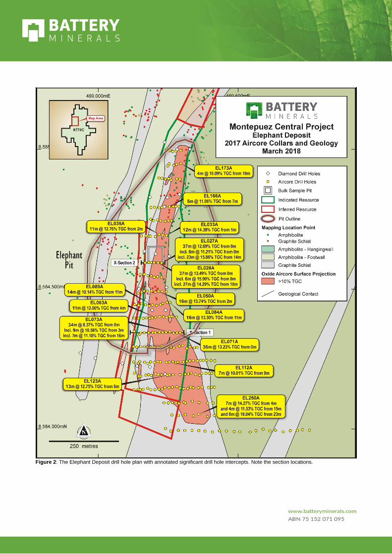
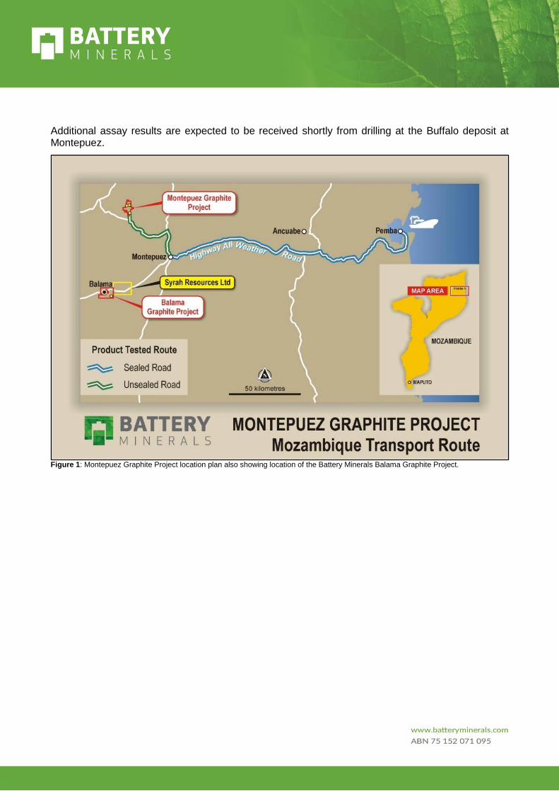
Figure 2: The Elephant Deposit drill hole plan with annotated significant drill hole intercepts. Note the section locations.
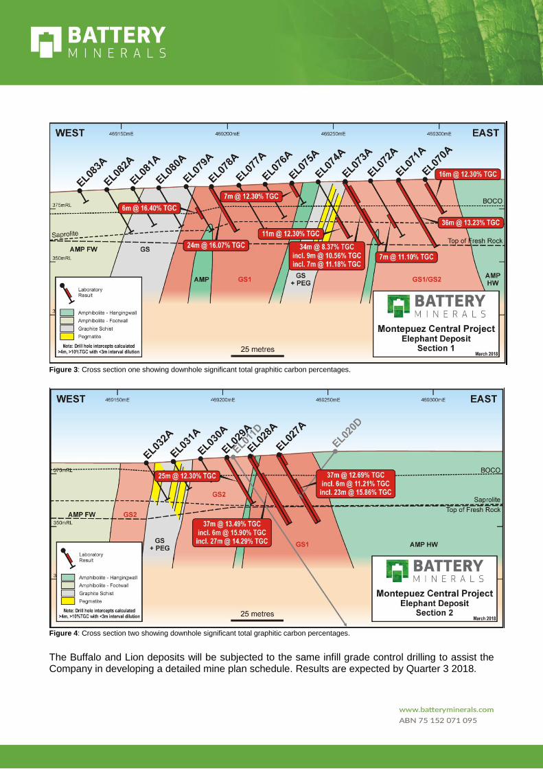
Figure 3: Cross section one showing downhole significant total graphitic carbon percentages.
Figure 4: Cross section two showing downhole significant total graphitic carbon percentages.
The Buffalo and Lion deposits will be subjected to the same infill grade control drilling to assist the Company in developing a detailed mine plan schedule. Results are expected by Quarter 3 2018.

Vanadium
Battery Minerals has disclosed comprehensive Mineral Resource estimates for the Montepuez and Balama Central Projects (see 15 February 2017 and 29 March 2018 ASX announcements for full details and Competent Person Statements). These Mineral Resource estimates included 0.28Mt of total contained V2O5. In the processing flowsheets being implemented for the Montepuez Project and contemplated for the Balama Central feasibility study, the graphite is recovered and all V2O5 reports to tailings. Both projects present a potentially significant upside commercial opportunity in the absence of any value currently attributed to the vanadium.
In response to customer interest, Battery Minerals has started test work to scope potential recovery of a saleable V2O5 concentrate from these tailings.
The Company will keep the market informed as results of the test work comes to hand.
Background Information
Battery Minerals Limited (“Battery Minerals”) is an ASX listed Australian company with two world-class graphite deposits in Mozambique, those being Montepuez and Balama Central. Battery Minerals has produced high quality graphite flake concentrate at multiple laboratories. Battery Minerals intends to commence graphite flake concentrate production from its Montepuez graphite project with first shipment in the March 2019 Quarter at export rates of 45,000 to 50,000tpa at an average flake concentrate grade of 96.7% TGC. In December 2017 and January 2018, Battery Minerals signed four binding offtake agreements for up to 41,000tpa of graphite concentrate, representing over 80% of Montepuez’s forecast annual production. The Mozambican Government has granted Battery Minerals a Mining Licence for its Montepuez graphite project and accepted the Company’s EIA for the Montepuez graphite project.
As Battery Minerals executes subsequent expansions, it expects production to grow to over 100,000 tonnes per annum graphite flake concentrate from its Montepuez graphite project by 2020.
Battery Minerals has also recently announced delivery of a scoping study on its Balama Central project, which comprises a Stage 1 production rate of 55,000tpa (B1) and Stage 2 rate of an additional ~55,000tpa (B2) for an aggregate of 110,000tpa from Balama. Balama is currently the subject of a feasibility study. Combined with Montepuez and subject to continued positive economic, social and technical investigations, Balama Central provides scope for self-funded growth from a ~50,000tpa production-rate in 2019 to more than 200,000tpa in 2022. (For full details on the Balama Central Graphite Project Scoping Study see ASX announcement dated 1st March 2018. Also see note on next page).
Investor Enquiries: Media Enquiries:
David Flanagan Managing Director, Battery Minerals Limited Tel: +61 8 6148 1000 Email: [email protected]
Paul Armstrong Read Corporate Tel: +61 8 9388 1474 Email: [email protected]
Tony Walsh Company Secretary, Battery Minerals Limited Tel: +61 408 289 476
Contact Details (Australian Office):
Ground Floor 10 Ord Street West Perth, WA 6005 Australia
Competent Persons Statement The information in this report that relates to Exploration Results is based on information compiled by Mr. Jason Livingstone, a Competent Person who is a member of both the Australian Institute of Mining and Metallurgy and the Australian Institute of Geoscientists. Mr. Jason Livingstone is a full-time employee of Battery Minerals Limited. Mr. Jason Livingstone has sufficient experience that is relevant to the style of mineralisation and type of deposit under consideration and to the activity being undertaken to qualify as a Competent Person as defined in the 2012 Edition of the ‘Australian Code for Reporting of Exploration Results, Mineral Resources and Ore Reserves’. Mr. Jason Livingstone consents to the inclusion of the matters based on his information in the form and context in which it appears. Please see BAT 15 February 2017 and 29 March 2018 ASX announcements for full details and Competent Person Statements relating to Mineral Resources and Ore Reserves.
Important Notice This ASX Announcement does not constitute an offer to acquire or sell or a solicitation of an offer to sell or purchase any securities in any jurisdiction. In particular, this ASX Announcement does not constitute an offer, solicitation or sale to any U.S. person or in the United States or any state or jurisdiction in which such an offer, tender offer, solicitation or sale would be unlawful. The securities referred to herein have not been and will not be registered under the United States Securities Act of 1933, as amended (the “Securities Act”), and ne ither such securities nor any interest or participation therein may not be offered, or sold, pledged or otherwise transferred, directly or indirectly, in the United States or to any U.S. person absent registration or an available exemption from, or a transaction not subject to, registration under the United States Securities Act of 1933.
Forward Looking Statements Statements and material contained in this document, particularly those regarding possible or assumed future performance, resources or potential growth of Battery Minerals Limited, industry growth or other trend projections are, or may be, forward looking statements. Such statements relate to future events and expectations and, as such, involve known and unknown risks and uncertainties. Such forecasts and information are not a guarantee of future performance and involve unknown risk and uncertainties, as well as other factors, many of which are beyond the control of Battery Minerals Limited. Information in this presentation has already been reported to the ASX. All references to future production and production & shipping targets and port access made in relation to Battery Minerals are subject to the completion of all necessary feasibility studies, permit applications, construction, financing arrangements, port access and execution of infrastructure-related agreements. Where such a reference is made, it should be read subject to this paragraph and in conjunction with further information about the Mineral Resources and Ore Reserves, as well as the relevant competent persons' statements.
Balama Central Scoping Study Parameters - Cautionary Statements in 1 March 2018 ASX announcement This Scoping Study has been undertaken to determine the potential viability of an open pit mine and graphite processing plant constructed onsite at the Balama Central Project and to form a view of the order of magnitude potential and a basis on which to complete further studies. The Scoping Study has been prepared to an accuracy level of ±35%. The results should not be considered a profit forecast or production forecast. The Scoping Study is a preliminary technical and economic study of the potential viability of the Balama Central Project. In accordance with the ASX Listing Rules, the Company advises it is based on low-level technical and economic assessments that are not sufficient to support the estimation of ore reserves. Further evaluation work including infill drilling and appropriate studies are ongoing and they will contribute to our ability to estimate any ore reserves or to provide any assurance of an economic development case. This study does not warrant that reserves will be reported. Other than the mineral resource upgrade in this announcement, Battery Minerals confirms that it is not aware of any new information or data that materially affects the information included in the original market announcement of 1 March 2018 and that all material assumptions and technical parameters underpinning the production estimates in the market announcements continue to apply and have not materially changed. Other than the mineral resource upgrade in this announcement, Battery Minerals confirms that the form and context in which the Scoping Study findings as presented have not been materially modified from the original market announcements. The total production target is based on Indicated resource exclusively. The Company has concluded that it has reasonable grounds for disclosing a production target. The Scoping Study is based on the material assumptions outlined elsewhere in this announcement. These include assumptions about the availability of funding. While Battery Minerals considers all the material assumptions to be based on reasonable grounds, there is no certainty that they will prove to be correct or that the range of outcomes indicated by the Scoping Study will be achieved. To achieve the range outcomes indicated in the Scoping Study, additional funding will likely be required. Investors should note that there is no certainty that Battery Minerals will be able to raise funding when needed. It is also possible that such funding may only be available on terms that dilute or otherwise affect the value of the Battery Minerals’ existing shares. It is possible that Battery Minerals could fund development of Balama Central from cashflow from its Montepuez graphite project, approximately 60kms north of Balama Central, which is currently in the early stages of construction. It is also possible that Battery Minerals could pursue other ‘value realisation’ strategies such as sale, partial sale, or joint venture of the Project. If it does, this could materially reduce Battery Minerals’ proportionate ownership of the Project. The Company has concluded it has a reasonable basis for providing the forward looking statements included in this announcement and believes that it has a reasonable basis to expect it will be able to fund the development of the Project. Given the uncertainties involved, investors should not make any investment decisions based solely on the results of the Scoping Study. Note: Battery Minerals released the results of a DFS on its Montepuez Project on 15 Feb 2017 and its Value Engineering Study results for Montepuez on 18 Oct 2017. The results Balama Central Scoping Study were released on 1 March 2018. These releases are available on Battery Minerals’ website & on ASX.
Appendix 1: JORC Code, 2012 Edition Table 1 Appendix X to Announcement: Balama Central Resource Upgrade. The Montepuez Central Graphite Project 8770C Mine License comprises an area covering 3,667Ha and is held 100% by Battery Minerals Limited via a locally owned subsidiary Suni Resources SA.
The Montepuez Central Project (MCP). This report pertains to the current grade control drilling to support detailed mine plan scheduling for the Project.
Section 1 Sampling Techniques and Data
Criteria JORC Code explanation BAT Commentary
Sampling techniques
· Nature and quality of sampling (e.g. cut channels, random chips, or specific specialised industry standard measurement tools appropriate to the minerals under investigation, such as down hole gamma sondes, or handheld XRF instruments, etc.). These examples should not be taken as limiting the broad meaning of sampling.
· Include reference to measures taken to ensure sample representivity and the appropriate calibration of any measurement tools or systems used.
· Aspects of the determination of mineralisation that are Material to the Public Report.
· In cases where ‘industry standard’ work has been done this would be relatively simple (e.g. ‘reverse circulation drilling was used to obtain 1 m samples from which 3 kg was pulverised to produce a 30 g charge for fire assay’). In other cases more explanation may be required, such as where there is coarse gold that has inherent sampling problems. Unusual commodities or mineralisation types (e.g. submarine nodules) may warrant disclosure of detailed information.
· The air core drilling was undertaken using a SHRAM RC rig with Metzke rig mounted cone splitter. A nominal 4.5 inch blade bit was used to achieve drilling penetration instead of a normal hammer bit.
· The samples were undertaken as part of grade control programme and were collected through a cone splitter with duplicate sample collected for archive and further QAQC purposes.
· The one-meter samples were collected in plastic sample bags and secured with cable ties to limit cross contamination in the shipping process to South Africa
· The one-meter samples were pulverised at the ALS preparation facility in South Africa.
Drilling techniques
· Drill type (e.g. core, reverse circulation, open-hole hammer, rotary air blast, auger, Bangka, sonic, etc.) and details (e.g. core diameter, triple or standard tube, depth of diamond tails, face-sampling bit or other type, whether core is oriented and if so, by what method, etc.).
· The drill rig used air core bit with RC sample innertube which drilled to blade refusal across the two deposits. The drill bit width was a nominal 4.5 inches.
· Elephant had a mean depth of 20.7 with a max depth of 37m
Drill sample recovery
· Method of recording and assessing core and chip sample recoveries and results assessed.
· Measures taken to maximise sample recovery and ensure representative nature of the samples.
· Sieved chip samples were collected and geologically logged and grade estimates (Visual Graphite Estimates)
· The samples were assessed for moisture and weight at the rig with data recorded in the database.
Section 1 Sampling Techniques and Data
Criteria JORC Code explanation BAT Commentary
· Whether a relationship exists between sample recovery and grade and whether sample bias may have occurred due to preferential loss/gain of fine/coarse material.
Logging · Whether core and chip samples have been geologically and geotechnically logged to a level of detail to support appropriate Mineral Resource estimation, mining studies and metallurgical studies.
· Whether logging is qualitative or quantitative in nature. Core (or costean, channel, etc.) photography.
· The total length and percentage of the relevant intersections logged.
·
· Drill holes were logged by trained and experienced geologists at the level of detail that supports the exploration report and any future inclusion in a resource estimation.
· Geological logging of all drill chips included; weathering zone, lithology, colour, mineralogy, mineralisation and visual graphite estimates.
· All data was initially captured on paper logging sheets and transferred to locked excel format tables for validation and was then loaded into the parent access database.
· All samples were sieved and stored in chip trays for archive purposes.
· The logging and reporting of graphite percentages on logs is semi-quantitative and not absolute.
Sub-sampling techniques and sample preparation
· If core, whether cut or sawn and whether quarter, half or all core taken.
· If non-core, whether riffled, tube sampled, rotary split, etc. and whether sampled wet or dry.
· For all sample types, the nature, quality and appropriateness of the sample preparation technique.
· Quality control procedures adopted for all sub-sampling stages to maximise representivity of samples.
· Measures taken to ensure that the sampling is representative of the in-situ material collected, including for instance results for field duplicate/second-half sampling.
· Whether sample sizes are appropriate to the grain size of the material being sampled.
· No subsampling has been undertaken post drilling.
· All samples were drilled dry and split through the cone splitter with a duplicate sample collected at the drill rig.
· The sampling undertaken to date is appropriate for grade control purposes and geological interpretation.
· The sampling technique is not suitable for metallurgical
or flake sizing analysis and ongoing metallurgical analysis is required. This is due to the semi pulverized nature of the sample obtained.
Quality of assay data and laboratory tests
· The nature, quality and appropriateness of the assaying and laboratory procedures used and whether the technique is considered partial or total.
· For geophysical tools, spectrometers, handheld XRF instruments, etc., the parameters used in determining the analysis including instrument make and
· Samples were submitted to ALS Johannesburg (South Africa) for sample preparation and geochemical analysis completed by ALS in Brisbane (Australia).
· Samples were sorted, oven dried at 105°C, crushed to -2-3mm and a 300g subsample taken for pulverising in an LM5 with 85% passing -75um.
· Loss on Ignition (LOI) has been determined between 105° and 1050° C. Results are reported on a dry sample basis.
Section 1 Sampling Techniques and Data
Criteria JORC Code explanation BAT Commentary
model, reading times, calibrations factors applied and their derivation, etc.
· Nature of quality control procedures adopted (e.g. standards, blanks, duplicates, external laboratory checks) and whether acceptable levels of accuracy (i.e. lack of bias) and precision have been established.
· Analysis includes Total Carbon Total Sulphur analysis by LECO, LOI TGA
· The detection limits and precision for the Total Graphitic Carbon (TGC) and Total Sulphur (TS) analysis are considered adequate for resource estimation.
· Trace element analysis was undertaken with ME-ICP85, using a borate fusion, with ICPAES determination. The suite of silicate included; Al, Ba, Ca, Cr, Fe, K, Mg, Mn, Na, P, Si, Sr, Ti, V.
· QAQC protocols include the use of; a coarse blank to monitor contamination during the preparation process, Certified Reference Material (CRM) at an insertion ratio of 1:20.
· All laboratory batch QC measures are checked for bias before final entry in the database, no bias has been identified in the results received. Duplicate samples returned good repeatability.
· The CRM TGC values range between 4-24%. The blank samples comprised 1-2kg sample of dolomitic marble quarried from a location 50km east of the project.
· Four CRM’s (GGC_01, GGC_04, GGC_05 and GGC_10) were used to monitor graphitic carbon, carbon and Sulphur.
· One base metal CRM (AMIS 346) was utilised to monitor vanadium.
Verification of sampling and assaying
· The verification of significant intersections by either independent or alternative company personnel.
· The use of twinned holes.
· Documentation of primary data, data entry procedures, data verification.
· Discuss any adjustment to assay data.
· Field work was managed on site by the Project Exploration Manager.
· No twinned drill holes studies have been undertaken on the project.
· Data entry procedures are described in the Logging section.
Location of data points
· Accuracy and quality of surveys used to locate drill holes (collar and down-hole surveys), trenches, mine workings and other locations used in Mineral Resource estimation.
· Specification of the grid system used.
· Quality and adequacy of topographic control.
· All spatial data was collected in WGS84 UTM Zone 37 South datum.
· Planned drill holes were surveyed using Garmin 62s GPS devices which typically have a ±5m error in the project area.
· Final collar locations were surveyed by GEOSURVEY utilising a differential GPS system with 0.02cm accuracy.
Data spacing and distribution
· Data spacing for reporting of Exploration Results.
· Historically all diamond drill holes were drilled at shallow angles (nominally 50°-60° towards 110-120° UTM grid east) in an attempt to drill across stratigraphy, however
Section 1 Sampling Techniques and Data
Criteria JORC Code explanation BAT Commentary
· Whether the data spacing and distribution is sufficient to establish the degree of geological and grade continuity appropriate for the Mineral Resource and Ore Reserve estimation procedure(s) and classifications applied.
· Whether sample compositing has been applied.
mineralised intercepts are not perpendicular to strike however are as close as could be obtained.
· The grade control programme, was drilled on 12.5m centers; on an east west grid 090° UTM grid will all drill holes completed at -60°
· The drill hole details are tabulated in Appendix 3.
Orientation of data in relation to geological structure
· Whether the orientation of sampling achieves unbiased sampling of possible structures and the extent to which this is known, considering the deposit type.
· If the relationship between the drilling orientation and the orientation of key mineralised structures is considered to have introduced a sampling bias, this should be assessed and reported if material.
· The drill holes were planned to test the continuity of the shallow oxide mineralisation at the Buffalo and Elephant deposits; and strike continuity of the interpreted >10% TGC zones.
Sample security
· The measures taken to ensure sample security.
· The samples are stored in the Company’s field base until laboratory dispatch, at which point the samples were transported to Pemba and air and road freighted by courier to ALS – Johannesburg, South Africa for sample preparation and then pulp couriered to ALS Brisbane Australia for geochemical analysis.
· Any visible signs of tampering are reported by the laboratory and none have been reported to date.
Audits or reviews
· The results of any audits or reviews of sampling techniques and data.
· Mr. Mark Burnett, Snowden Principal Consultant visited site in July 2016 and Shaun Searle of RungePincockMinarco (representative of Robert Dennis, CP) visited in June to July 2015 as part of their Competent Person field procedure assessment for the 15 February 2017 Mineral Resource. No issues with the field procedures or geological data gathering was identified by both Resource CP’s during their respective
Section 2 Reporting of Exploration Results
Criteria JORC Code explanation Commentary
Mineral tenement and land tenure status
· Type, reference name/number, location and ownership including agreements or material issues with third parties such as joint ventures, partnerships, overriding royalties, native title interests, historical sites, wilderness or national park and environmental settings.
· The security of the tenure held at the time of reporting along with any known
· The Montepuez Central Graphite Project 8770C Mine License comprises an area covering 3,667Ha and is held 100% by Battery Minerals Limited via a locally owned subsidiary Suni Resources SA. The license application has been applied for graphite and vanadium extraction. The prior Exploration License was 6216L.
· The mine license application was submitted on the 9th May 2017 and was granted on the 22nd March 2018.
· The Montepuez Central Project contains the Elephant, Buffalo and Lion deposits however resource and reserve estimations were limited to Elephant and Buffalo during the DFS released 15 February 2017.
Section 2 Reporting of Exploration Results
Criteria JORC Code explanation Commentary
impediments to obtaining a licence to operate in the area.
· Statutory approvals for mine development are progressing and on schedule and include the Environmental License submission, Resettlement Action Plan and DUAT (land access).
· BAT has established a good working relationship with the government departments of Mozambique and continues to build its relationship with the local community.
· The Company is not aware of any impediments relating to the licenses or area.
Exploration done by other parties
· Acknowledgment and appraisal of exploration by other parties.
· There is no record of past exploration activities on the original (6216L) exploration license and BAT has conducted all the exploration work to date.
·
· Mine License 8770C has included, VTEM airborne survey, mapping & rock chip sampling, trenching and resource-reserve drilling.
Geology · Deposit type, geological setting and style of mineralisation.
· The deposits were discovered after drill testing a series of coincident VTEM conductors and prospective stratigraphy with mapped graphitic outcrop occurrences.
· The mining concession occurs within the Xixano Complex and traverse the tectonic contacts between the Nairoto, Xixano and Montepuez Complexes. The Xixano Complex includes a variety of metasupracrustal rocks enveloping predominantly mafic igneous rocks and granulites that form the core of a regional north-northeast to south-southwest-trending synform. The paragneisses include mica gneiss and schist, quartzfeldspar gneiss, metasandstone, quartzite and marble.
· The metamorphic grade in the paragneiss is dominantly amphibolite facies, although granulite facies rocks occur locally in the region. The oldest dated rock in the Xixano Complex is a weakly deformed meta-rhyolite which is interlayed in the meta-supracrustal rocks and which gives a reliable extrusion age of 818 +/- 10 Ma.
· Graphite-bearing mica schist and gneiss are found in different tectonic complexes in the Cabo Delgado Province of Mozambique.
· Local geology comprises dolerite, meta-sediments, amphibolites, psammite with graphitic metasediments and graphitic schists.
· At Buffalo the deformation strained zone of GSQF, psammite and amphibolite exhibits brittle and brittle-ductile structures that intersect each other, the deformation zone is where graphite mineralisation is located and is part of a regional metamorphic and deformation event.
· At the nearby Elephant deposit, the metamorphic banding and foliation strike about 005° and the GSQF dips moderately steep west.
· The Montepuez deposits are disseminated with graphite dispersed within gneiss. The graphite forms as a result of high grade metamorphism of organic carbonaceous
Section 2 Reporting of Exploration Results
Criteria JORC Code explanation Commentary
matter, the protolith in which the graphite has formed may have been globular carbon, composite flakes, homogenous flakes or crystalline graphite.
· Parasitic folds in the drill core indicate the mineralization is complexly folded and steeply dipping faults and sheers have been observed.
Drill hole Information
· A summary of all information material to the understanding of the exploration results including a tabulation of the following information for all Material drill holes:
· easting and northing of the drillhole collar,
· elevation or RL (Reduced Level – elevation above sea level in metres) of the drill hole collar,
· dip and azimuth of the hole,
· down hole length and interception depth,
· hole length.
· If the exclusion of this information is justified on the basis that the information is not Material and this exclusion does not detract from the understanding of the report, the Competent Person should clearly explain why this is the case.
· A summary table of drill hole details with drill plan are listed in Appendix 3.
· All drilling, within this grade control programme has been undertaken on a nominal 25m sections and drill holes spacing on 12.5m centers.
· Graphite samples selected for laboratory analyses were determined from the field logging of Visual Graphite Estimates which include the analysis of non-mineralised (amphibolite) to better constrain the geological and grade models
Data aggregation methods
· In reporting Exploration Results, weighting averaging techniques, maximum and/or minimum grade truncations (e.g. cutting of high grades) and cut-off grades are usually Material and should be stated.
· Where aggregate intercepts incorporate short lengths of high grade results and longer lengths of low grade results, the procedure used for such aggregation should be stated and some typical examples of such aggregations should be shown in detail.
· The assumptions used for any reporting of metal equivalent values should be clearly stated.
· Nothing to report at this stage
· Drill hole intercept calculations were >4m; >10% TGC with less than 3m of internal dilution (<10% TGC)
· No chemical conversions or metal equivalent values have been applied.
Section 2 Reporting of Exploration Results
Criteria JORC Code explanation Commentary
Relationship between mineralisation widths and intercept lengths
· These relationships are particularly important in the reporting of Exploration Results.
· If the geometry of the mineralisation with respect to the drill hole angle is known, its nature should be reported.
· If it is not known and only the down hole lengths are reported, there should be a clear statement to this effect (e.g. ‘down hole length, true width not known’).
· The drill holes were drilled to assist in developing further the geological and grade models
· The geology at the Buffalo deposit is relatively well constrained with Indicated and Inferred Mineral Resources and Probable Ore Reserve Classifications.
· The dip of the orebody is steeply west and holes have been drilled eastward -50-60° to intersect the graphite mineralisation at the highest angle possible. A northerly plunge was observed during the resource evaluation process.
· The geology of the nearby Elephant deposit is less structurally complex than Buffalo and comprises a moderately steep westerly graphitic schist package bound by amphibolite and notable psammite in the southern portion of the orebody.
Diagrams · Appropriate maps and sections (with scales) and tabulations of intercepts should be included for any significant discovery being reported These should include, but not be limited to a plan view of drill hole collar locations.
· A drill hole plan and cross-section is provided in Figures1, 2 and 3.
Balanced reporting
· Where comprehensive reporting of all Exploration Results is not practicable, representative reporting of both low and high grades and/or widths should be practiced to
· The report is believed to include all representative and relevant information pertaining the planning and execution of the drilling programme being discussed.
Other substantive exploration data
· Other exploration data, if meaningful and material, should be reported including (but not limited to): geological observations; geophysical survey results; geochemical survey results; bulk samples – size and method of treatment; metallurgical test results; bulk density, groundwater, geotechnical and rock characteristics; potential deleterious or contaminating substances.
Not what has not been reported previously.

Section 2 Reporting of Exploration Results
Criteria JORC Code explanation Commentary
Further work · The nature and scale of planned further work (e.g. tests for lateral extensions or depth extensions or large-scale step-out drilling).
· Diagrams clearly highlighting the areas of possible extensions, including the main geological interpretations and future drilling areas, provided this information is not commercially sensitive.
· Further work for the MCP will focus on mine infrastructure development and the completion of the grade control drilling over the Buffalo deposit where 2600m currently remains undrilled due to impact of the wet season in late 2017.
· An additional 1000m of drilling will also target prospective oxide targets
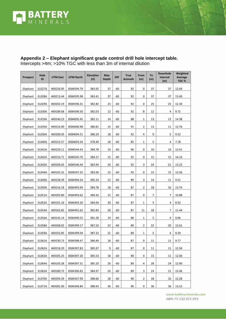
Appendix 2 – Elephant significant grade control drill hole intercept table. Intercepts >4m; >10% TGC with less than 3m of internal dilution
Prospect Hole
ID UTM East UTM North
Elevation (rl)
Max Depth
DIP True
Azimuth From (m)
To (m)
Downhole interval
(m)
Weighted Average TGC %
Elephant EL027A 469226.95 8584594.79 383.92 37 -60 92 0 37 37 12.69
Elephant EL028A 469213.44 8584595.98 383.41 37 -60 92 0 37 37 13.49
Elephant EL029A 469202.19 8584596.31 382.82 25 -60 92 0 25 25 12.30
Elephant EL030A 469189.68 8584596.50 382.03 12 -60 92 8 12 4 9.72
Elephant EL033A 469240.23 8584695.45 382.11 14 -60 88 1 13 12 14.38
Elephant EL035A 469216.90 8584696.98 380.81 15 -60 91 2 13 11 12.76
Elephant EL036A 469200.03 8584694.51 380.29 18 -60 92 4 9 5 9.52
Elephant EL040A 469152.57 8584693.34 378.49 18 -60 85 1 5 4 7.78
Elephant EL041A 469229.11 8584544.43 384.78 14 -60 96 0 10 10 12.41
Elephant EL042A 469216.71 8584545.76 384.27 15 -60 92 0 15 15 14.16
Elephant EL043A 469204.45 8584546.44 383.94 24 -60 92 3 24 21 13.22
Elephant EL044A 469192.31 8584547.25 383.06 15 -60 92 0 15 15 13.36
Elephant EL049A 469228.39 8584494.24 385.24 22 -60 89 3 14 11 9.51
Elephant EL050A 469216.18 8584493.94 384.78 18 -60 87 2 18 16 13.74
Elephant EL051A 469203.80 8584493.62 384.42 15 -60 87 0 7 7 10.88
Elephant EL052A 469191.16 8584493.20 384.04 30 -60 87 1 5 4 8.92
Elephant EL054A 469165.82 8584491.62 382.83 20 -60 87 11 18 7 11.44
Elephant EL056A 469142.14 8584490.55 381.28 19 -60 88 1 5 4 9.06
Elephant EL058A 469268.02 8584399.17 387.50 22 -60 89 2 22 20 15.61
Elephant EL059A 469255.85 8584399.04 387.32 21 -60 89 1 5 4 9.29
Elephant EL061A 469230.73 8584398.47 386.49 18 -60 87 0 11 11 9.77
Elephant EL062A 469218.20 8584397.83 385.97 9 -60 87 0 11 11 12.94
Elephant EL063A 469205.25 8584397.20 385.53 18 -60 90 4 15 11 12.00
Elephant EL064A 469193.28 8584397.31 385.20 26 -60 89 4 28 24 12.90
Elephant EL065A 469180.75 8584396.83 384.97 24 -60 89 3 24 21 13.46
Elephant EL070A 469293.59 8584347.09 388.60 18 -60 90 2 18 16 12.28
Elephant EL071A 469281.00 8584346.84 388.43 36 -60 90 0 36 36 13.23
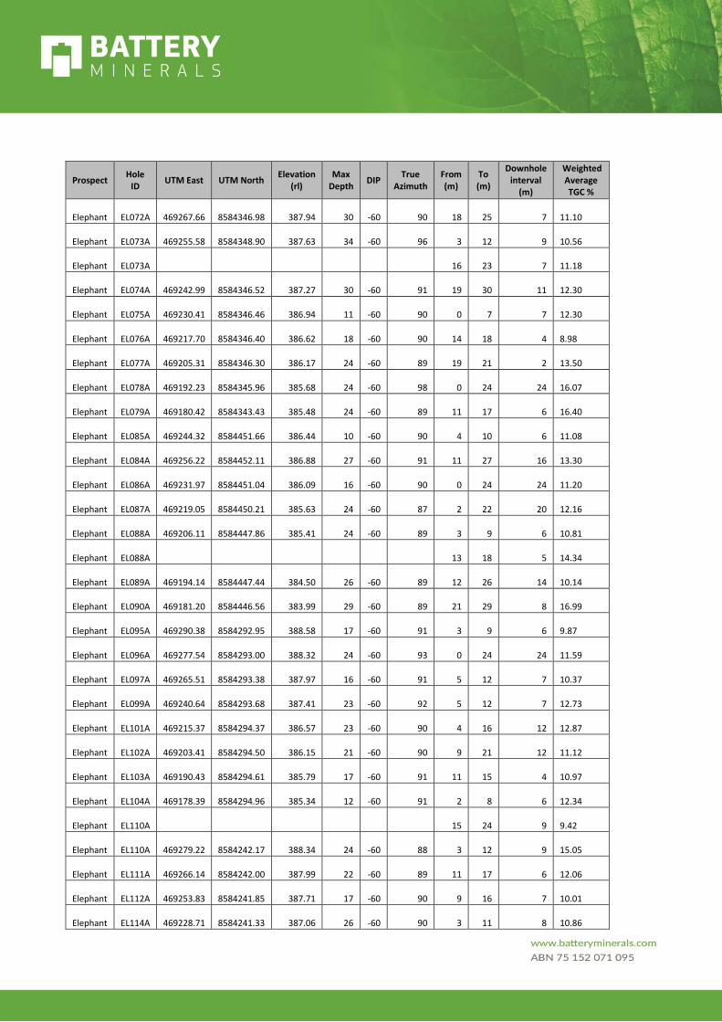
Prospect Hole
ID UTM East UTM North
Elevation (rl)
Max Depth
DIP True
Azimuth From (m)
To (m)
Downhole interval
(m)
Weighted Average TGC %
Elephant EL072A 469267.66 8584346.98 387.94 30 -60 90 18 25 7 11.10
Elephant EL073A 469255.58 8584348.90 387.63 34 -60 96 3 12 9 10.56
Elephant EL073A 16 23 7 11.18
Elephant EL074A 469242.99 8584346.52 387.27 30 -60 91 19 30 11 12.30
Elephant EL075A 469230.41 8584346.46 386.94 11 -60 90 0 7 7 12.30
Elephant EL076A 469217.70 8584346.40 386.62 18 -60 90 14 18 4 8.98
Elephant EL077A 469205.31 8584346.30 386.17 24 -60 89 19 21 2 13.50
Elephant EL078A 469192.23 8584345.96 385.68 24 -60 98 0 24 24 16.07
Elephant EL079A 469180.42 8584343.43 385.48 24 -60 89 11 17 6 16.40
Elephant EL085A 469244.32 8584451.66 386.44 10 -60 90 4 10 6 11.08
Elephant EL084A 469256.22 8584452.11 386.88 27 -60 91 11 27 16 13.30
Elephant EL086A 469231.97 8584451.04 386.09 16 -60 90 0 24 24 11.20
Elephant EL087A 469219.05 8584450.21 385.63 24 -60 87 2 22 20 12.16
Elephant EL088A 469206.11 8584447.86 385.41 24 -60 89 3 9 6 10.81
Elephant EL088A 13 18 5 14.34
Elephant EL089A 469194.14 8584447.44 384.50 26 -60 89 12 26 14 10.14
Elephant EL090A 469181.20 8584446.56 383.99 29 -60 89 21 29 8 16.99
Elephant EL095A 469290.38 8584292.95 388.58 17 -60 91 3 9 6 9.87
Elephant EL096A 469277.54 8584293.00 388.32 24 -60 93 0 24 24 11.59
Elephant EL097A 469265.51 8584293.38 387.97 16 -60 91 5 12 7 10.37
Elephant EL099A 469240.64 8584293.68 387.41 23 -60 92 5 12 7 12.73
Elephant EL101A 469215.37 8584294.37 386.57 23 -60 90 4 16 12 12.87
Elephant EL102A 469203.41 8584294.50 386.15 21 -60 90 9 21 12 11.12
Elephant EL103A 469190.43 8584294.61 385.79 17 -60 91 11 15 4 10.97
Elephant EL104A 469178.39 8584294.96 385.34 12 -60 91 2 8 6 12.34
Elephant EL110A 15 24 9 9.42
Elephant EL110A 469279.22 8584242.17 388.34 24 -60 88 3 12 9 15.05
Elephant EL111A 469266.14 8584242.00 387.99 22 -60 89 11 17 6 12.06
Elephant EL112A 469253.83 8584241.85 387.71 17 -60 90 9 16 7 10.01
Elephant EL114A 469228.71 8584241.33 387.06 26 -60 90 3 11 8 10.86
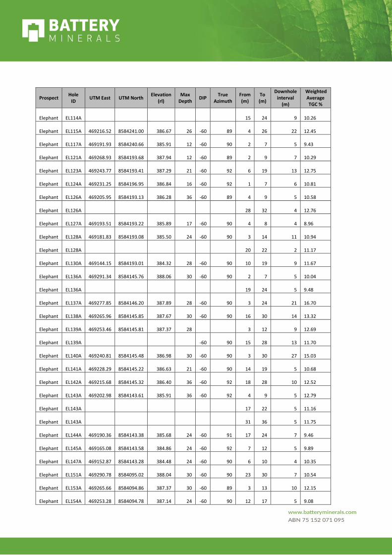
Prospect Hole
ID UTM East UTM North
Elevation (rl)
Max Depth
DIP True
Azimuth From (m)
To (m)
Downhole interval
(m)
Weighted Average TGC %
Elephant EL114A 15 24 9 10.26
Elephant EL115A 469216.52 8584241.00 386.67 26 -60 89 4 26 22 12.45
Elephant EL117A 469191.93 8584240.66 385.91 12 -60 90 2 7 5 9.43
Elephant EL121A 469268.93 8584193.68 387.94 12 -60 89 2 9 7 10.29
Elephant EL123A 469243.77 8584193.41 387.29 21 -60 92 6 19 13 12.75
Elephant EL124A 469231.25 8584196.95 386.84 16 -60 92 1 7 6 10.81
Elephant EL126A 469205.95 8584193.13 386.28 36 -60 89 4 9 5 10.58
Elephant EL126A 28 32 4 12.76
Elephant EL127A 469193.51 8584193.22 385.89 17 -60 90 4 8 4 8.96
Elephant EL128A 469181.83 8584193.08 385.50 24 -60 90 3 14 11 10.94
Elephant EL128A 20 22 2 11.17
Elephant EL130A 469144.15 8584193.01 384.32 28 -60 90 10 19 9 11.67
Elephant EL136A 469291.34 8584145.76 388.06 30 -60 90 2 7 5 10.04
Elephant EL136A 19 24 5 9.48
Elephant EL137A 469277.85 8584146.20 387.89 28 -60 90 3 24 21 16.70
Elephant EL138A 469265.96 8584145.85 387.67 30 -60 90 16 30 14 13.32
Elephant EL139A 469253.46 8584145.81 387.37 28 3 12 9 12.69
Elephant EL139A -60 90 15 28 13 11.70
Elephant EL140A 469240.81 8584145.48 386.98 30 -60 90 3 30 27 15.03
Elephant EL141A 469228.29 8584145.22 386.63 21 -60 90 14 19 5 10.68
Elephant EL142A 469215.68 8584145.32 386.40 36 -60 92 18 28 10 12.52
Elephant EL143A 469202.98 8584143.61 385.91 36 -60 92 4 9 5 12.79
Elephant EL143A 17 22 5 11.16
Elephant EL143A 31 36 5 11.75
Elephant EL144A 469190.36 8584143.38 385.68 24 -60 91 17 24 7 9.46
Elephant EL145A 469165.08 8584143.58 384.86 24 -60 92 7 12 5 9.89
Elephant EL147A 469152.87 8584143.28 384.48 24 -60 90 6 10 4 10.35
Elephant EL151A 469290.78 8584095.02 388.04 30 -60 90 23 30 7 10.54
Elephant EL153A 469265.66 8584094.86 387.37 30 -60 89 3 13 10 12.15
Elephant EL154A 469253.28 8584094.78 387.14 24 -60 90 12 17 5 9.08
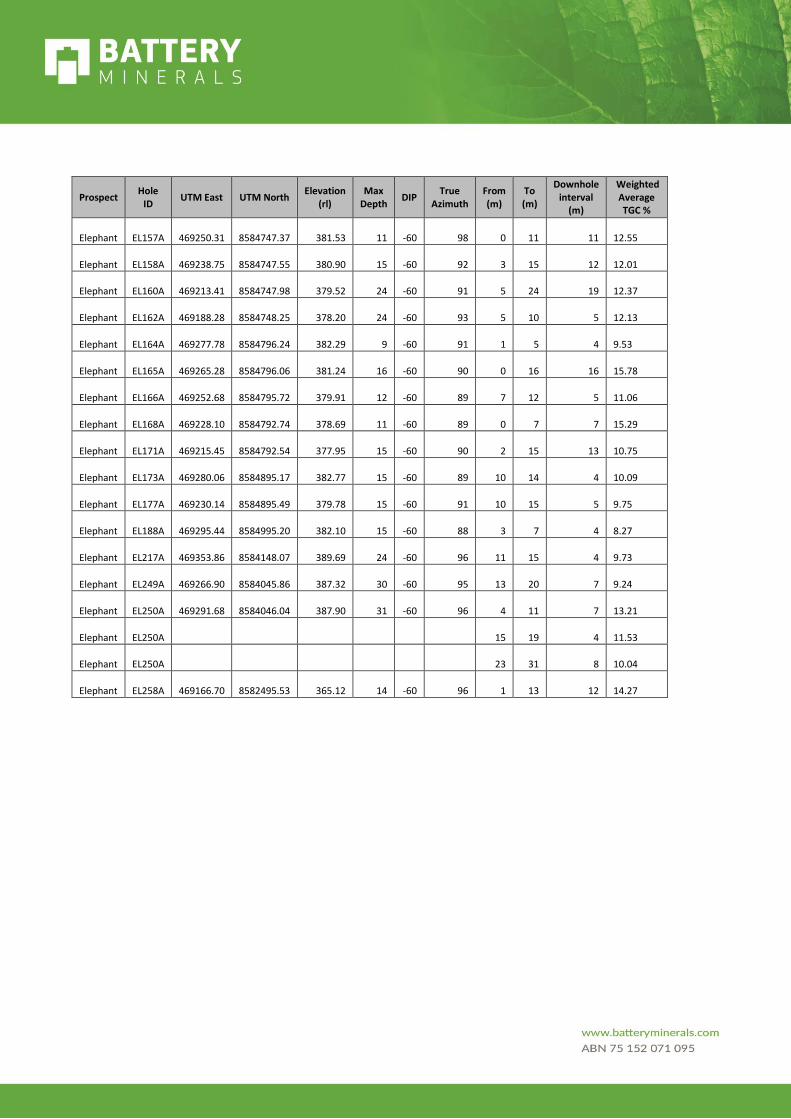
Prospect Hole
ID UTM East UTM North
Elevation (rl)
Max Depth
DIP True
Azimuth From (m)
To (m)
Downhole interval
(m)
Weighted Average TGC %
Elephant EL157A 469250.31 8584747.37 381.53 11 -60 98 0 11 11 12.55
Elephant EL158A 469238.75 8584747.55 380.90 15 -60 92 3 15 12 12.01
Elephant EL160A 469213.41 8584747.98 379.52 24 -60 91 5 24 19 12.37
Elephant EL162A 469188.28 8584748.25 378.20 24 -60 93 5 10 5 12.13
Elephant EL164A 469277.78 8584796.24 382.29 9 -60 91 1 5 4 9.53
Elephant EL165A 469265.28 8584796.06 381.24 16 -60 90 0 16 16 15.78
Elephant EL166A 469252.68 8584795.72 379.91 12 -60 89 7 12 5 11.06
Elephant EL168A 469228.10 8584792.74 378.69 11 -60 89 0 7 7 15.29
Elephant EL171A 469215.45 8584792.54 377.95 15 -60 90 2 15 13 10.75
Elephant EL173A 469280.06 8584895.17 382.77 15 -60 89 10 14 4 10.09
Elephant EL177A 469230.14 8584895.49 379.78 15 -60 91 10 15 5 9.75
Elephant EL188A 469295.44 8584995.20 382.10 15 -60 88 3 7 4 8.27
Elephant EL217A 469353.86 8584148.07 389.69 24 -60 96 11 15 4 9.73
Elephant EL249A 469266.90 8584045.86 387.32 30 -60 95 13 20 7 9.24
Elephant EL250A 469291.68 8584046.04 387.90 31 -60 96 4 11 7 13.21
Elephant EL250A 15 19 4 11.53
Elephant EL250A 23 31 8 10.04
Elephant EL258A 469166.70 8582495.53 365.12 14 -60 96 1 13 12 14.27
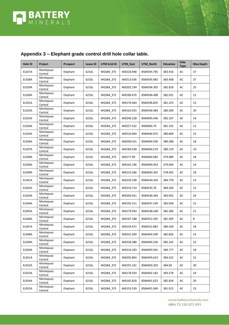
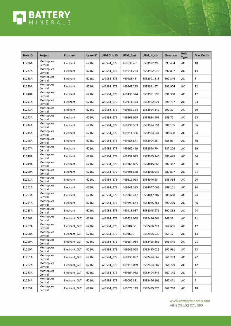
Appendix 3 – Elephant grade control drill hole collar table.
Hole ID Project Prospect Lease ID UTM Grid ID UTM_East UTM_North Elevation Hole Type
Max Depth
EL027A Montepuez Central
Elephant 6216L WGS84_37S 469226.948 8584594.785 383.916 AC 37
EL028A Montepuez Central
Elephant 6216L WGS84_37S 469213.436 8584595.982 383.408 AC 37
EL029A Montepuez Central
Elephant 6216L WGS84_37S 469202.194 8584596.305 382.818 AC 25
EL030A Montepuez Central
Elephant 6216L WGS84_37S 469189.676 8584596.498 382.031 AC 12
EL031A Montepuez Central
Elephant 6216L WGS84_37S 469176.464 8584596.835 381.253 AC 15
EL032A Montepuez Central
Elephant 6216L WGS84_37S 469163.925 8584596.984 380.369 AC 20
EL033A Montepuez Central
Elephant 6216L WGS84_37S 469240.228 8584695.446 382.107 AC 14
EL034A Montepuez Central
Elephant 6216L WGS84_37S 469227.532 8584694.79 381.332 AC 12
EL035A Montepuez Central
Elephant 6216L WGS84_37S 469216.904 8584696.975 380.809 AC 15
EL036A Montepuez Central
Elephant 6216L WGS84_37S 469200.031 8584694.509 380.288 AC 18
EL037A Montepuez Central
Elephant 6216L WGS84_37S 469189.538 8584694.519 380.129 AC 10
EL038A Montepuez Central
Elephant 6216L WGS84_37S 469177.99 8584694.082 379.489 AC 18
EL039A Montepuez Central
Elephant 6216L WGS84_37S 469165.196 8584694.054 379.049 AC 14
EL040A Montepuez Central
Elephant 6216L WGS84_37S 469152.566 8584693.342 378.492 AC 18
EL041A Montepuez Central
Elephant 6216L WGS84_37S 469229.108 8584544.434 384.778 AC 14
EL042A Montepuez Central
Elephant 6216L WGS84_37S 469216.714 8584545.76 384.269 AC 15
EL043A Montepuez Central
Elephant 6216L WGS84_37S 469204.451 8584546.444 383.942 AC 24
EL044A Montepuez Central
Elephant 6216L WGS84_37S 469192.311 8584547.249 383.058 AC 15
EL045A Montepuez Central
Elephant 6216L WGS84_37S 469179.934 8584548.248 382.384 AC 21
EL046A Montepuez Central
Elephant 6216L WGS84_37S 469167.188 8584552.295 381.495 AC 8
EL047A Montepuez Central
Elephant 6216L WGS84_37S 469154.972 8584552.883 380.169 AC 18
EL048A Montepuez Central
Elephant 6216L WGS84_37S 469241.309 8584494.509 385.856 AC 14
EL049A Montepuez Central
Elephant 6216L WGS84_37S 469228.388 8584494.236 385.242 AC 22
EL050A Montepuez Central
Elephant 6216L WGS84_37S 469216.183 8584493.942 384.777 AC 18
EL051A Montepuez Central
Elephant 6216L WGS84_37S 469203.804 8584493.623 384.422 AC 15
EL052A Montepuez Central
Elephant 6216L WGS84_37S 469191.161 8584493.203 384.04 AC 30
EL053A Montepuez Central
Elephant 6216L WGS84_37S 469178.503 8584492.182 383.578 AC 24
EL054A Montepuez Central
Elephant 6216L WGS84_37S 469165.818 8584491.623 382.834 AC 20
EL055A Montepuez Central
Elephant 6216L WGS84_37S 469153.539 8584491.069 381.912 AC 23

Hole ID Project Prospect Lease ID UTM Grid ID UTM_East UTM_North Elevation Hole Type
Max Depth
EL056A Montepuez Central
Elephant 6216L WGS84_37S 469142.141 8584490.546 381.283 AC 19
EL057A Montepuez Central
Elephant 6216L WGS84_37S 469279.339 8584399.75 387.887 AC 12
EL058A Montepuez Central
Elephant 6216L WGS84_37S 469268.018 8584399.174 387.497 AC 22
EL059A Montepuez Central
Elephant 6216L WGS84_37S 469255.852 8584399.041 387.32 AC 21
EL060A Montepuez Central
Elephant 6216L WGS84_37S 469243.17 8584398.837 386.906 AC 16
EL061A Montepuez Central
Elephant 6216L WGS84_37S 469230.729 8584398.465 386.486 AC 18
EL062A Montepuez Central
Elephant 6216L WGS84_37S 469218.196 8584397.825 385.968 AC 9
EL063A Montepuez Central
Elephant 6216L WGS84_37S 469205.247 8584397.203 385.534 AC 18
EL064A Montepuez Central
Elephant 6216L WGS84_37S 469193.277 8584397.31 385.196 AC 26
EL065A Montepuez Central
Elephant 6216L WGS84_37S 469180.747 8584396.826 384.971 AC 24
EL066A Montepuez Central
Elephant 6216L WGS84_37S 469168.284 8584396.651 384.574 AC 30
EL067A Montepuez Central
Elephant 6216L WGS84_37S 469155.636 8584396.341 384.249 AC 16
EL068A Montepuez Central
Elephant 6216L WGS84_37S 469142.705 8584396.285 383.906 AC 18
EL069A Montepuez Central
Elephant 6216L WGS84_37S 469130.377 8584395.668 383.693 AC 12
EL070A Montepuez Central
Elephant 6216L WGS84_37S 469293.587 8584347.088 388.596 AC 18
EL071A Montepuez Central
Elephant 6216L WGS84_37S 469281.004 8584346.844 388.43 AC 36
EL072A Montepuez Central
Elephant 6216L WGS84_37S 469267.656 8584346.981 387.936 AC 30
EL073A Montepuez Central
Elephant 6216L WGS84_37S 469255.582 8584348.9 387.634 AC 34
EL074A Montepuez Central
Elephant 6216L WGS84_37S 469242.987 8584346.519 387.273 AC 30
EL075A Montepuez Central
Elephant 6216L WGS84_37S 469230.409 8584346.455 386.941 AC 11
EL076A Montepuez Central
Elephant 6216L WGS84_37S 469217.698 8584346.401 386.615 AC 18
EL077A Montepuez Central
Elephant 6216L WGS84_37S 469205.306 8584346.299 386.173 AC 24
EL078A Montepuez Central
Elephant 6216L WGS84_37S 469192.227 8584345.956 385.675 AC 24
EL079A Montepuez Central
Elephant 6216L WGS84_37S 469180.418 8584343.427 385.481 AC 24
EL080A Montepuez Central
Elephant 6216L WGS84_37S 469167.63 8584345.794 384.885 AC 21
EL081A Montepuez Central
Elephant 6216L WGS84_37S 469155.443 8584346.092 384.568 AC 20
EL082A Montepuez Central
Elephant 6216L WGS84_37S 469142.762 8584345.772 384.2 AC 23
EL083A Montepuez Central
Elephant 6216L WGS84_37S 469129.828 8584343.143 383.842 AC 6
EL084A Montepuez Central
Elephant 6216L WGS84_37S 469256.224 8584452.111 386.882 AC 27
EL085A Montepuez Central
Elephant 6216L WGS84_37S 469244.317 8584451.661 386.439 AC 10
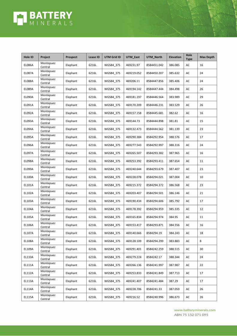
Hole ID Project Prospect Lease ID UTM Grid ID UTM_East UTM_North Elevation Hole Type
Max Depth
EL086A Montepuez Central
Elephant 6216L WGS84_37S 469231.97 8584451.042 386.085 AC 16
EL087A Montepuez Central
Elephant 6216L WGS84_37S 469219.052 8584450.207 385.632 AC 24
EL088A Montepuez Central
Elephant 6216L WGS84_37S 469206.11 8584447.856 385.406 AC 24
EL089A Montepuez Central
Elephant 6216L WGS84_37S 469194.142 8584447.444 384.498 AC 26
EL090A Montepuez Central
Elephant 6216L WGS84_37S 469181.197 8584446.564 383.989 AC 29
EL091A Montepuez Central
Elephant 6216L WGS84_37S 469170.209 8584446.231 383.529 AC 26
EL092A Montepuez Central
Elephant 6216L WGS84_37S 469157.158 8584445.681 382.62 AC 16
EL093A Montepuez Central
Elephant 6216L WGS84_37S 469144.73 8584444.898 381.81 AC 15
EL094A Montepuez Central
Elephant 6216L WGS84_37S 469132.473 8584444.562 381.139 AC 23
EL095A Montepuez Central
Elephant 6216L WGS84_37S 469290.384 8584292.954 388.576 AC 17
EL096A Montepuez Central
Elephant 6216L WGS84_37S 469277.543 8584292.997 388.316 AC 24
EL097A Montepuez Central
Elephant 6216L WGS84_37S 469265.507 8584293.382 387.965 AC 16
EL098A Montepuez Central
Elephant 6216L WGS84_37S 469253.392 8584293.411 387.654 AC 11
EL099A Montepuez Central
Elephant 6216L WGS84_37S 469240.644 8584293.679 387.407 AC 23
EL100A Montepuez Central
Elephant 6216L WGS84_37S 469228.078 8584294.021 387.004 AC 10
EL101A Montepuez Central
Elephant 6216L WGS84_37S 469215.372 8584294.372 386.568 AC 23
EL102A Montepuez Central
Elephant 6216L WGS84_37S 469203.407 8584294.501 386.146 AC 21
EL103A Montepuez Central
Elephant 6216L WGS84_37S 469190.434 8584294.606 385.792 AC 17
EL104A Montepuez Central
Elephant 6216L WGS84_37S 469178.392 8584294.959 385.335 AC 12
EL105A Montepuez Central
Elephant 6216L WGS84_37S 469165.834 8584294.974 384.95 AC 11
EL106A Montepuez Central
Elephant 6216L WGS84_37S 469153.417 8584293.871 384.556 AC 16
EL107A Montepuez Central
Elephant 6216L WGS84_37S 469140.666 8584294.19 384.243 AC 18
EL108A Montepuez Central
Elephant 6216L WGS84_37S 469128.109 8584294.299 383.883 AC 8
EL109A Montepuez Central
Elephant 6216L WGS84_37S 469291.401 8584242.259 388.515 AC 30
EL110A Montepuez Central
Elephant 6216L WGS84_37S 469279.224 8584242.17 388.344 AC 24
EL111A Montepuez Central
Elephant 6216L WGS84_37S 469266.136 8584241.997 387.987 AC 22
EL112A Montepuez Central
Elephant 6216L WGS84_37S 469253.833 8584241.849 387.713 AC 17
EL113A Montepuez Central
Elephant 6216L WGS84_37S 469241.407 8584241.484 387.29 AC 17
EL114A Montepuez Central
Elephant 6216L WGS84_37S 469228.706 8584241.33 387.059 AC 26
EL115A Montepuez Central
Elephant 6216L WGS84_37S 469216.52 8584240.996 386.673 AC 26

Hole ID Project Prospect Lease ID UTM Grid ID UTM_East UTM_North Elevation Hole Type
Max Depth
EL116A Montepuez Central
Elephant 6216L WGS84_37S 469203.863 8584240.842 386.294 AC 16
EL117A Montepuez Central
Elephant 6216L WGS84_37S 469191.933 8584240.661 385.907 AC 12
EL118A Montepuez Central
Elephant 6216L WGS84_37S 469179.27 8584240.45 385.477 AC 26
EL119A Montepuez Central
Elephant 6216L WGS84_37S 469166.597 8584240.196 385.074 AC 30
EL120A Montepuez Central
Elephant 6216L WGS84_37S 469297.46 8584196.513 388.411 AC 30
EL121A Montepuez Central
Elephant 6216L WGS84_37S 469268.931 8584193.682 387.935 AC 12
EL122A Montepuez Central
Elephant 6216L WGS84_37S 469256.495 8584193.571 387.684 AC 7
EL123A Montepuez Central
Elephant 6216L WGS84_37S 469243.768 8584193.407 387.285 AC 21
EL124A Montepuez Central
Elephant 6216L WGS84_37S 469231.247 8584196.951 386.843 AC 16
EL125A Montepuez Central
Elephant 6216L WGS84_37S 469218.899 8584193.367 386.647 AC 14
EL126A Montepuez Central
Elephant 6216L WGS84_37S 469205.95 8584193.127 386.281 AC 36
EL127A Montepuez Central
Elephant 6216L WGS84_37S 469193.514 8584193.223 385.886 AC 17
EL128A Montepuez Central
Elephant 6216L WGS84_37S 469181.826 8584193.084 385.497 AC 24
EL129A Montepuez Central
Elephant 6216L WGS84_37S 469156.425 8584193.064 384.576 AC 18
EL130A Montepuez Central
Elephant 6216L WGS84_37S 469144.152 8584193.005 384.323 AC 28
EL131A Montepuez Central
Elephant 6216L WGS84_37S 469131.469 8584192.775 383.966 AC 30
EL132A Montepuez Central
Elephant 6216L WGS84_37S 469168.975 8584192.974 385.052 AC 21
EL133A Montepuez Central
Elephant 6216L WGS84_37S 469154.061 8584240.337 384.757 AC 21
EL134A Montepuez Central
Elephant 6216L WGS84_37S 469141.608 8584240.082 384.352 AC 24
EL135A Montepuez Central
Elephant 6216L WGS84_37S 469129.34 8584239.848 383.901 AC 12
EL136A Montepuez Central
Elephant 6216L WGS84_37S 469291.335 8584145.761 388.062 AC 30
EL137A Montepuez Central
Elephant 6216L WGS84_37S 469277.85 8584146.199 387.89 AC 28
EL138A Montepuez Central
Elephant 6216L WGS84_37S 469265.957 8584145.852 387.669 AC 30
EL139A Montepuez Central
Elephant 6216L WGS84_37S 469253.455 8584145.812 387.365 AC 28
EL140A Montepuez Central
Elephant 6216L WGS84_37S 469240.81 8584145.479 386.982 AC 30
EL141A Montepuez Central
Elephant 6216L WGS84_37S 469228.289 8584145.216 386.634 AC 21
EL142A Montepuez Central
Elephant 6216L WGS84_37S 469215.678 8584145.319 386.398 AC 36
EL143A Montepuez Central
Elephant 6216L WGS84_37S 469202.98 8584143.605 385.908 AC 36
EL144A Montepuez Central
Elephant 6216L WGS84_37S 469190.358 8584143.379 385.684 AC 24
EL145A Montepuez Central
Elephant 6216L WGS84_37S 469165.081 8584143.584 384.863 AC 24

Hole ID Project Prospect Lease ID UTM Grid ID UTM_East UTM_North Elevation Hole Type
Max Depth
EL146A Montepuez Central
Elephant 6216L WGS84_37S 469177.813 8584143.539 385.223 AC 24
EL147A Montepuez Central
Elephant 6216L WGS84_37S 469152.873 8584143.283 384.475 AC 24
EL148A Montepuez Central
Elephant 6216L WGS84_37S 469140.71 8584143.041 384.114 AC 22
EL149A Montepuez Central
Elephant 6216L WGS84_37S 469128.161 8584143.168 383.719 AC 18
EL150A Montepuez Central
Elephant 6216L WGS84_37S 469302.672 8584095.172 388.294 AC 32
EL151A Montepuez Central
Elephant 6216L WGS84_37S 469290.781 8584095.022 388.036 AC 30
EL152A Montepuez Central
Elephant 6216L WGS84_37S 469277.941 8584095.011 387.645 AC 23
EL153A Montepuez Central
Elephant 6216L WGS84_37S 469265.66 8584094.864 387.365 AC 30
EL154A Montepuez Central
Elephant 6216L WGS84_37S 469253.279 8584094.779 387.136 AC 24
EL155A Montepuez Central
Elephant 6216L WGS84_37S 469240.637 8584094.636 386.967 AC 23
EL156A Montepuez Central
Elephant 6216L WGS84_37S 469262.876 8584747.212 382.267 AC 5
EL157A Montepuez Central
Elephant 6216L WGS84_37S 469250.313 8584747.372 381.533 AC 11
EL158A Montepuez Central
Elephant 6216L WGS84_37S 469238.751 8584747.552 380.898 AC 15
EL159A Montepuez Central
Elephant 6216L WGS84_37S 469225.808 8584747.687 380.165 AC 21
EL160A Montepuez Central
Elephant 6216L WGS84_37S 469213.407 8584747.975 379.521 AC 24
EL161A Montepuez Central
Elephant 6216L WGS84_37S 469200.735 8584748.106 378.915 AC 6
EL162A Montepuez Central
Elephant 6216L WGS84_37S 469188.282 8584748.251 378.199 AC 24
EL163A Montepuez Central
Elephant 6216L WGS84_37S 469290.276 8584796.327 383.111 AC 9
EL164A Montepuez Central
Elephant 6216L WGS84_37S 469277.778 8584796.238 382.285 AC 9
EL165A Montepuez Central
Elephant 6216L WGS84_37S 469265.279 8584796.056 381.238 AC 16
EL166A Montepuez Central
Elephant 6216L WGS84_37S 469252.683 8584795.721 379.905 AC 12
EL167A Montepuez Central
Elephant 6216L WGS84_37S 469240.177 8584792.936 379.145 AC 18
EL168A Montepuez Central
Elephant 6216L WGS84_37S 469228.102 8584792.739 378.685 AC 11
EL169A Montepuez Central
Elephant 6216L WGS84_37S 469203.383 8584792.033 377.49 AC 15
EL170A Montepuez Central
Elephant 6216L WGS84_37S 469191.475 8584791.929 376.786 AC 15
EL171A Montepuez Central
Elephant 6216L WGS84_37S 469215.451 8584792.541 377.949 AC 15
EL172A Montepuez Central
Elephant 6216L WGS84_37S 469293.394 8584895.311 385.123 AC 15
EL173A Montepuez Central
Elephant 6216L WGS84_37S 469280.064 8584895.165 382.769 AC 15
EL174A Montepuez Central
Elephant 6216L WGS84_37S 469267.006 8584895.171 381.781 AC 15
EL175A Montepuez Central
Elephant 6216L WGS84_37S 469254.947 8584895.27 381.085 AC 15

Hole ID Project Prospect Lease ID UTM Grid ID UTM_East UTM_North Elevation Hole Type
Max Depth
EL176A Montepuez Central
Elephant 6216L WGS84_37S 469242.648 8584895.277 380.373 AC 15
EL177A Montepuez Central
Elephant 6216L WGS84_37S 469230.144 8584895.491 379.784 AC 15
EL178A Montepuez Central
Elephant 6216L WGS84_37S 469217.336 8584895.347 379.114 AC 15
EL179A Montepuez Central
Elephant 6216L WGS84_37S 469293.049 8584946.302 383.98 AC 15
EL180A Montepuez Central
Elephant 6216L WGS84_37S 469280.493 8584944.577 381.958 AC 15
EL181A Montepuez Central
Elephant 6216L WGS84_37S 469267.941 8584943.616 381.201 AC 15
EL182A Montepuez Central
Elephant 6216L WGS84_37S 469255.22 8584942.394 380.284 AC 15
EL183A Montepuez Central
Elephant 6216L WGS84_37S 469245.64 8584941.584 379.899 AC 15
EL184A Montepuez Central
Elephant 6216L WGS84_37S 469281.419 8584993.342 380.432 AC 15
EL185A Montepuez Central
Elephant 6216L WGS84_37S 469268.951 8584993.339 379.879 AC 15
EL186A Montepuez Central
Elephant 6216L WGS84_37S 469256.732 8584994.008 379.276 AC 15
EL187A Montepuez Central
Elephant 6216L WGS84_37S 469244.204 8584994.081 378.859 AC 15
EL188A Montepuez Central
Elephant 6216L WGS84_37S 469295.441 8584995.196 382.102 AC 15
EL189A Montepuez Central
Elephant 6216L WGS84_37S 469302.812 8584294.219 388.846 AC 17
EL190A Montepuez Central
Elephant 6216L WGS84_37S 469315.263 8584294.421 389.044 AC 20
EL191A Montepuez Central
Elephant 6216L WGS84_37S 469327.416 8584294.809 389.347 AC 9
EL192A Montepuez Central
Elephant 6216L WGS84_37S 469339.147 8584294.878 389.552 AC 36
EL193A Montepuez Central
Elephant 6216L WGS84_37S 469353.047 8584295.195 389.791 AC 32
EL194A Montepuez Central
Elephant 6216L WGS84_37S 469303.83 8584243.358 388.78 AC 32
EL195A Montepuez Central
Elephant 6216L WGS84_37S 469316.338 8584243.715 389.132 AC 7
EL196A Montepuez Central
Elephant 6216L WGS84_37S 469328.562 8584244.015 389.335 AC 4
EL197A Montepuez Central
Elephant 6216L WGS84_37S 469340.603 8584244.395 389.557 AC 17
EL198A Montepuez Central
Elephant 6216L WGS84_37S 469353.823 8584244.722 389.724 AC 36
EL199A Montepuez Central
Elephant 6216L WGS84_37S 469366.868 8584245.101 389.953 AC 30
EL200A Montepuez Central
Elephant 6216L WGS84_37S 469377.977 8584245.409 390.203 AC 24
EL201A Montepuez Central
Elephant 6216L WGS84_37S 469390.602 8584245.653 390.311 AC 20
EL202A Montepuez Central
Elephant 6216L WGS84_37S 469403.582 8584245.967 390.63 AC 11
EL203A Montepuez Central
Elephant 6216L WGS84_37S 469416.411 8584246.164 390.871 AC 12
EL204A Montepuez Central
Elephant 6216L WGS84_37S 469309.668 8584196.971 388.789 AC 24
EL205A Montepuez Central
Elephant 6216L WGS84_37S 469322.06 8584196.991 389.112 AC 17

Hole ID Project Prospect Lease ID UTM Grid ID UTM_East UTM_North Elevation Hole Type
Max Depth
EL206A Montepuez Central
Elephant 6216L WGS84_37S 469334.838 8584197.051 389.31 AC 30
EL207A Montepuez Central
Elephant 6216L WGS84_37S 469346.423 8584197 389.594 AC 23
EL208A Montepuez Central
Elephant 6216L WGS84_37S 469359.53 8584197.086 389.817 AC 24
EL209A Montepuez Central
Elephant 6216L WGS84_37S 469372.13 8584197.035 390.024 AC 35
EL210A Montepuez Central
Elephant 6216L WGS84_37S 469384.228 8584197.104 390.268 AC 32
EL211A Montepuez Central
Elephant 6216L WGS84_37S 469397.287 8584197.072 390.608 AC 30
EL212A Montepuez Central
Elephant 6216L WGS84_37S 469409.48 8584196.926 390.744 AC 17
EL213A Montepuez Central
Elephant 6216L WGS84_37S 469303.677 8584146.923 388.533 AC 33
EL214A Montepuez Central
Elephant 6216L WGS84_37S 469315.667 8584147.148 388.64 AC 30
EL215A Montepuez Central
Elephant 6216L WGS84_37S 469328.763 8584147.666 388.953 AC 30
EL216A Montepuez Central
Elephant 6216L WGS84_37S 469341.542 8584147.856 389.338 AC 27
EL217A Montepuez Central
Elephant 6216L WGS84_37S 469353.862 8584148.068 389.687 AC 24
EL218A Montepuez Central
Elephant 6216L WGS84_37S 469378.753 8584148.75 390.076 AC 30
EL219A Montepuez Central
Elephant 6216L WGS84_37S 469391.265 8584149.089 390.341 AC 36
EL220A Montepuez Central
Elephant 6216L WGS84_37S 469403.527 8584149.375 390.444 AC 36
EL221A Montepuez Central
Elephant 6216L WGS84_37S 469415.7 8584149.542 390.655 AC 18
EL222A Montepuez Central
Elephant 6216L WGS84_37S 469316.097 8584093.274 388.596 AC 33
EL223A Montepuez Central
Elephant 6216L WGS84_37S 469340.271 8584093.645 389.12 AC 24
EL224A Montepuez Central
Elephant 6216L WGS84_37S 469364.237 8584094.276 389.707 AC 32
EL225A Montepuez Central
Elephant 6216L WGS84_37S 469389.06 8584094.684 390.206 AC 24
EL226A Montepuez Central
Elephant 6216L WGS84_37S 469414.627 8584094.853 390.653 AC 24
EL227A Montepuez Central
Elephant 6216L WGS84_37S 469760.742 8583994.876 398.138 AC 29
EL228A Montepuez Central
Elephant 6216L WGS84_37S 469735.91 8583994.839 397.632 AC 36
EL229A Montepuez Central
Elephant 6216L WGS84_37S 469711.123 8583994.336 397.239 AC 18
EL230A Montepuez Central
Elephant 6216L WGS84_37S 469686.237 8583994.117 396.729 AC 16
EL231A Montepuez Central
Elephant 6216L WGS84_37S 469660.903 8583993.745 396.266 AC 18
EL232A Montepuez Central
Elephant 6216L WGS84_37S 469636.108 8583993.383 395.826 AC 17
EL233A Montepuez Central
Elephant 6216L WGS84_37S 469611.536 8583993.031 395.177 AC 24
EL234A Montepuez Central
Elephant 6216L WGS84_37S 469586.169 8583992.775 394.631 AC 24
EL235A Montepuez Central
Elephant 6216L WGS84_37S 469561.272 8583992.543 394.022 AC 16
Hole ID Project Prospect Lease ID UTM Grid ID UTM_East UTM_North Elevation Hole Type
Max Depth
EL236A Montepuez Central
Elephant 6216L WGS84_37S 469536.481 8583992.295 393.484 AC 10
EL237A Montepuez Central
Elephant 6216L WGS84_37S 469511.264 8583992.075 392.897 AC 14
EL238A Montepuez Central
Elephant 6216L WGS84_37S 469486.45 8583991.816 392.346 AC 8
EL239A Montepuez Central
Elephant 6216L WGS84_37S 469461.215 8583991.67 391.904 AC 12
EL240A Montepuez Central
Elephant 6216L WGS84_37S 469436.324 8583991.599 391.368 AC 12
EL241A Montepuez Central
Elephant 6216L WGS84_37S 469411.174 8583992.021 390.767 AC 23
EL242A Montepuez Central
Elephant 6216L WGS84_37S 469386.354 8583994.142 390.27 AC 30
EL243A Montepuez Central
Elephant 6216L WGS84_37S 469361.959 8583994.509 389.72 AC 33
EL244A Montepuez Central
Elephant 6216L WGS84_37S 469336.553 8583994.594 389.105 AC 36
EL245A Montepuez Central
Elephant 6216L WGS84_37S 469311.386 8583994.541 388.408 AC 24
EL246A Montepuez Central
Elephant 6216L WGS84_37S 469286.641 8583994.56 388.01 AC 30
EL247A Montepuez Central
Elephant 6216L WGS84_37S 469262.419 8583994.79 387.209 AC 19
EL248A Montepuez Central
Elephant 6216L WGS84_37S 469237.073 8583995.146 386.445 AC 34
EL249A Montepuez Central
Elephant 6216L WGS84_37S 469266.895 8584045.863 387.317 AC 30
EL250A Montepuez Central
Elephant 6216L WGS84_37S 469291.678 8584046.043 387.897 AC 31
EL251A Montepuez Central
Elephant 6216L WGS84_37S 469316.068 8584046.58 388.534 AC 26
EL252A Montepuez Central
Elephant 6216L WGS84_37S 469341.335 8584047.063 389.151 AC 24
EL253A Montepuez Central
Elephant 6216L WGS84_37S 469366.417 8584047.387 389.668 AC 24
EL254A Montepuez Central
Elephant 6216L WGS84_37S 469390.684 8584045.261 390.229 AC 36
EL255A Montepuez Central
Elephant 6216L WGS84_37S 469415.957 8584045.471 390.862 AC 24
EL256A Montepuez Central
Elephant_GLT 6216L WGS84_37S 469228.098 8582496.664 363.39 AC 21
EL257A Montepuez Central
Elephant_GLT 6216L WGS84_37S 469204.36 8582496.221 362.685 AC 17
EL258A Montepuez Central
Elephant_GLT 6216L WGS84_37S 469166.7 8582495.535 365.12 AC 14
EL259A Montepuez Central
Elephant_GLT 6216L WGS84_37S 469154.084 8582495.265 365.545 AC 21
EL260A Montepuez Central
Elephant_GLT 6216L WGS84_37S 469142.058 8582495.021 365.991 AC 23
EL261A Montepuez Central
Elephant_GLT 6216L WGS84_37S 469130.887 8582494.669 366.283 AC 22
EL262A Montepuez Central
Elephant_GLT 6216L WGS84_37S 469118.039 8582494.687 366.729 AC 12
EL263A Montepuez Central
Elephant_GLT 6216L WGS84_37S 469104.938 8582494.643 367.145 AC 5
EL264A Montepuez Central
Elephant_GLT 6216L WGS84_37S 469092.381 8582496.101 367.471 AC 6
EL265A Montepuez Central
Elephant_GLT 6216L WGS84_37S 469079.119 8582495.975 367.788 AC 18

Hole ID Project Prospect Lease ID UTM Grid ID UTM_East UTM_North Elevation Hole Type
Max Depth
EL266A Montepuez Central
Elephant_GLT 6216L WGS84_37S 469066.288 8582495.555 367.97 AC 7