Astoria Formation - Oregon Department of Geology and Mineral
27
COAS TAL LANDFORMS N EW POR T - LI NCOLN C IT Y Vo l. 36 , No.5 May 1974 STATE OF OREGON DEPARTMENT OF GEOLOGY AND MINERAL INDUSTRIES
Transcript of Astoria Formation - Oregon Department of Geology and Mineral
COAS TAL LANDFORMS N EW POR T -LI NCOLN C IT Y
Vol. 36 , No.5 May 1974
STATE OF OREGON DEPARTMENT OF GEOLOGY AND MINERAL INDUSTRIES
The Ore Bin Published Monthly By
STATE OF OREGON DEPARTMENT OF GEOLOGY AND MINERAL INDUSTRIES
Head Office: 1069 State Office Bldg., Portland, Oregon - 97201 Telephone: 229 - 5580
FIELD OFFICES 2033 First Street 521 N. E. "E" Street Boker 97814 Grants Pass 97526
xxxxxxxxxxxxxxxxxxxx
Subscription rate - $2.00 per colenc:br yeor Available bock issues $.25 each
Second closs postage paid at Portland, Oregon
GOVERNING BOARD
R. W. deWeese, Portland , Chairman Willicwn E. Miller, Bend
H. lyle Von Gordon, Grants Pass
STATE GEOLOGIST
R. E. Corcoran
GEOLOGISTS IN CHARGE OF FIELD OFFICES Howard C. Brooks, Boker Len Romp, Grants Pass
Permission i, gront.d to r.int information contained herein . Credit gillen the Stot. of Oregon o.pcrtment of Geology and Min.al Industri.
for compiling thi, information will be appreciated.
Stote of O r egon Deportmentof Geology ond Minerol Indu$ITies 1069 Siote Office Bldg. Portlond Oregon 97201
The ORE BIN Volume 36,No.5 May 1974
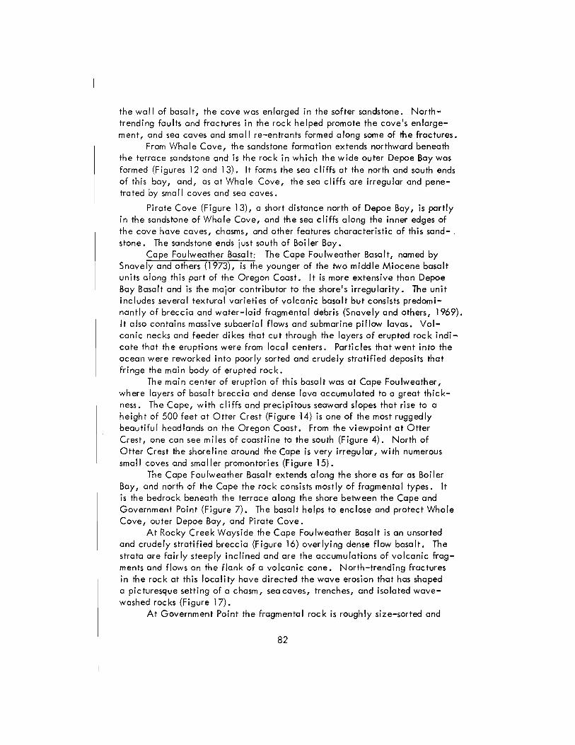
ROCK UNITS AND COASTAL LANDFORMS BETWEEN NEWPORT AND liNCOLN CITY, OREGON
Ernest H. lund Deportment of Geo logy, University of Oregon
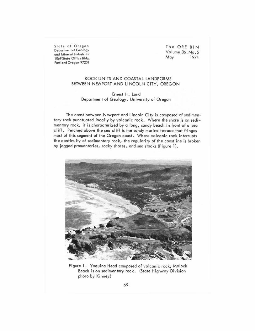
The coost between Newport and lincoln City is composed of sedimentary rock punctuated locally by volcanic rock. Where the shore is on sedimentary rock, it is characterized by a long, sandy beach in front of a sea cliff. Perched above the sea cliff is the sandy marine terrace that fringes most of this segment of the Oregon coost. Where vo lcan ic rock interrupts the continuity of sedimentary rock, the regularity of the coostline is broken by jagged promontories, rocky shares, and sea stocks (Figure I).
Figure 1. Yaqu ina Head composed of vo lcanic roc k; Moloch Beach is on sedimentary rock. (State Highway Division photo by Kinney)
69
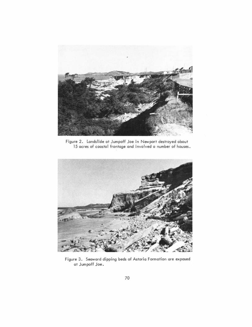
Figure 2. landslide at Jumpoff Joe in Newport destroyed about 15 acres of coastol frontoge and involved a number of houses.
Figure 3 . Seaward dipping beds of Astoria Formation are exposed at Jumpoff Joe.
70
A number of different rock units (geologic formations) are exposed along this part of the Oregon Coast (see accompanying geologic map). Each unit is characterized by a kind of rock or suite of rocks that distinguishes it from other units. For this reason, each unit plays a different role in shaping the coastal landforms.
In the following text, the geologic formations are discussed from oldest to youngest beginning with those of Eocene age, dating back 40 or 50 million years ago, to those of Quaternary age, some of which are forming today. The distinctive landforms associated with each unit are described and also illustrated in the photographs.
Eocene formations
Si letz River Volcanics: This formation, consisting of basalt flows and pyroc las tic rocks, is not exposed along the shore but crops out east of Devi Is Lake and is responsible for the rugged topography in the Coast Range to the east.
Nestucca Formation: These late Eocene siltstones and interbedded sandstones are the bedrock beneath the marine terrace north of Si letz Bay. They underlie the beach sand at Lincoln City and are often exposed during the winter and early spring after storm waves have swept away the sand. The Nestucca Formation is described in more detail by Snavely and others (1969).
Oligocene formations
Si Itstone of Alsea: This formation, named informally by Snavely and others (1969), consists of massive to thick-bedded tuffaceous si Itstone and very fine-grained sandstone. It is the bedrock along the east side of Siletz Bay and is exposed in a roadcut along U. S. Highway 101 just south of Schooner Creek at the north end of Siletz Bay.
Yaquina Formation: The Yaquina Formation is of diverse composition, consisting mainly of sandstone but also of conglomerate and siltstone (Snavely and others, 1969). It is the bedrock beneath the marine terrace south of Siletz Bay and is exposed in a roadcut at the south end of the bay, but neither it nor the siltstone of Alsea is exposed along the shore in this segment of the coast.
Miocene formations
Nye Mudstone: The Nye Mudstone, of lower Miocene age, is described by Snavely and others (1964) as a " ..• mixture of clay, silt, and very fine sand-size particles in varying proportions; the lithologic designation differs from place to place, but commonly is mudstone and siltstone, and less commonly si Ity, very fine-grained sandstone." The Nye crops out along
71
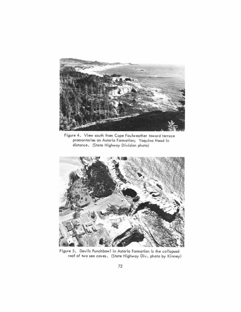
Figure 4. View south from Cope Foulweather toward terrace promontories on Astoria Formation; Yaquina Head in distance. (State Highway Di ... ision photo)
Figure 5. De ... ils Punchbowl in Astoria Formation is the collapsed roof of two sea ca ... es. (State Highwa y Di .... photo by Kinney)
72
the sea cliff at Newport beneath the Astoria Formation and is exposed in contact with the Astoria Formation at Jumpoff Joe, 1~ miles north of Yaquina Bay. I t does not crop out a long the shore north of Yaqui na Head but underlies the terrace south of Gleneden Beach.
Beds of the Nye Mudstone have a high c lay content and therefore have low shearing strength, especially when wet; areas underlain by this formation are subject to landslides along cliffs and in steep terrain. Along the shore between Yaquina Bay and Yaquina Head, the beds have a seaward inclination of as much as 30 degrees, which increases the threat of landslides in this formation. Much of the slumping along this part of the coost is attributed to yielding of weak beds along inclined bedding planes, and bedrock slumps are numerous. The largest slumped area is at the Jumpoff Joe locality in Newport; it involves about 15 acres along a quarter mi Ie of the shore (F igure 2).
Astoria Formation: The middle Miocene Astoria Formation, which overlies the Nye Mudstone, is described by Snavely and others (1969) as consisting" .•• principally of olive-gray, fine- to medium-grained micaceous, arkosic sandstone and dark carbonaceous siltstone. The sandstone beds range from massive to thin-bedded and generally are thicker in the upper part of the sequence." The Astoria Formation contains many fossi Is.
Between Yaquina Bay and Yaquina Head, the Astoria Formation is exposed above the Nye Mudstone in the sea cliff (Figure 3). From Yaquina Head to Cape Foulweather it is the bedrock below the terrace sediments, and it crops out extensively in the sea cliff and on the wave-cut platform between these points. It is exposed at inner Depoe Bay, in the sea cliffs at Boiler Bay, and at the mouth of Fogarty Creek. It underlies the terrace at Lincoln Beach but is not exposed along the beach.
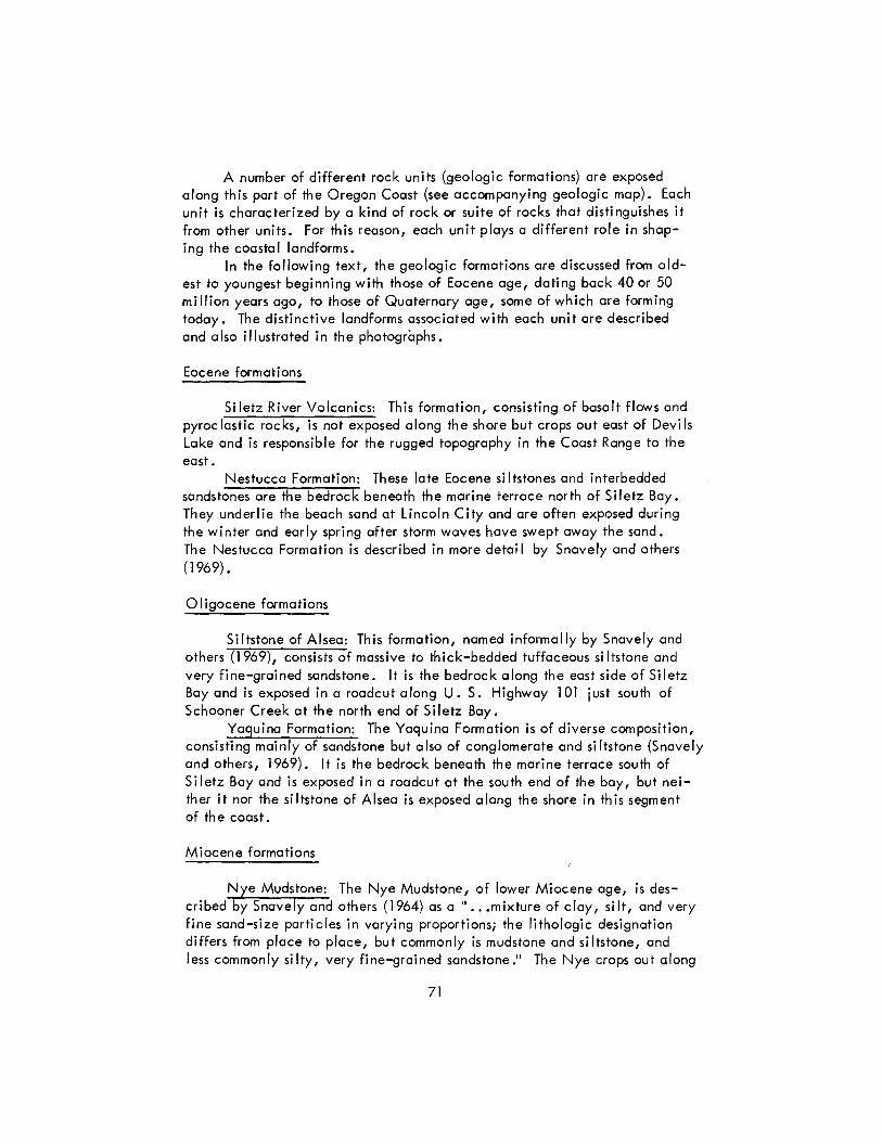
From Yaquina Head to Otter Rock, a continuous, gently sloping beach lies in front of the sea cliff on the Astoria Formation and overlying terrace sandstone (Figure 4). The northern part is Beverly Beach and the southern part Moloch Beach.
Two promontories (Figure 4) south of Cope Foulweather are segments of a marine terrace developed on the Astoria Formation. The terrace is capped by a layer of sandstone, which gives the flat surface to these points of land. The Astoria Formation is exposed along the outer edges of the promontories where wave erosion has removed the terrace sandstone. I t forms the present-day wave-cut platform, where marine gardens with many tidal pools support a luxuriant and varied assemblage of plants and animals.
The southernmost of the two promontories, at Otter Rock community, is the site of the famed Devils Punchbowl (Figure 5). This hole in the terrace was formed by collapse of the roof where two sea caves met, one from the north and the other from the west. Water enters the bowl at high tide, and during storms it churns and foams as in a boiling pot.
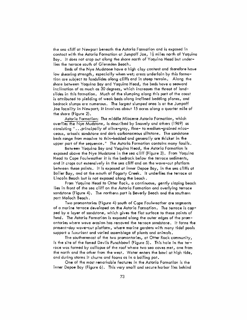
One of the most remarkable features in the Astoria Formation is the inner Depoe Bay (Figure 6). This very small and secure harbor lies behind
73
Figure 6. Basaltic wall shelters inner Depoe Boy from storm waves and erosion. (S tote Highway Div ision photo by Kinney)
Figure 7. Government point is a wave - cut platform on volcanic rock; Boiler Bay to north is eroded into sedimentary rock. (State Highway Div ision photo by Kinney)
74
a wall of basalt lava rock, and its access to the sea is a narrow chasm through the basalt wall. The basin is a low area in the topography formed principally by stream erosion along North and South Depoe Creeks. Much of the shaping of this small basin was done during the most recent glacial stage, the Wisconsin, when sea level stood several hundred feet lower than it does now. At that time the passage through the wall was a gorge through which the ancestral Depoe Creek flowed. With melting of the glacial ice, the sea rose to a level that caused flooding at the lower end of the drainage basin of Depoe Creek. In this respect, the origin of this small bay has something in common with large water bodies such as Yaquina Bay, where rise in sea level has "drowned" their lower parts and formed estuaries.
Boiler Bay (Figure 7), about 1~ miles north of Depoe Bay, is eroded in the Astoria Formation, which is exposed beneath a thick terrace deposit along the inner cliffs of the bay. Boiler Bay was formed where wave erosion breached a layer of the same basalt as that at Depoe Bay. A fault and other fractures trending at nearly right angles to the shore helped direct the erosion.
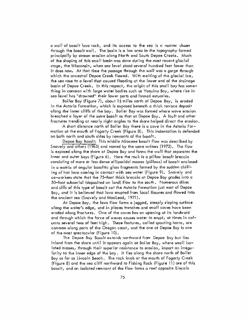
A short distance north of Boiler Bay there is a cove in the Astoria Formation at the mouth of Fogarty Creek (Figure 8). This indentation is defended on both north and south sides by remnants of the basalt.
Depoe Bay Basalt: This middle Miocene basalt flow was described by Snavely and others (1965) and named by the same writers (1973). The flow is exposed a long the shore at Depoe Bay and forms the wa II that separates the inner and outer bays (Figure 6). Here the rock is a pillow basalt breccia consisting of more or less dense ellipsoidal masses (pi IIows) of basalt enclosed in a matrix of angular basaltic glass fragments formed by the sudden chilling of hot lava coming in contact with sea water (Figure 9). Snavely and co-workers state that the 75-foot thick breccia at Depoe Bay grades into a 50-foot subaerial (deposited on land) flow to the south. Numerous dikes and sills of this type of basalt cut the Astoria Formation just east of Depoe Bay, and it is believed that lava erupted from local fissures and flowed into the ancient sea (Snavely and Macleod, 1971).
At Depoe Bay, the lava flow forms a jagged, steeply sloping surface along the water's edge, and in places trenches and small caves have been eroded along fractures. One of the caves has an opening at its landward end through which the force of waves causes water to erupt, at times in columns several tens of feet high. These features, called spouting horns, are common a long parts of the Oregon coast, and the one at Depoe Bay is one of the most spectacular (Figure 10).
The Depoe Bay Basalt extends northward from Depoe Bay but lies inland from the shore until it appears again at Boiler Bay, where small isolated masses, through their superior resistance to erosion, impart an irregularity to the inner edge of the bay. It lies along the shore north of Boi ler Bay as far as Lincoln Beach. The rock knob at the mouth of Fogarty Creek (Figure 8) and the sea cliff northward to Fishing Rock (Figure 11) are of this basalt, and an isolated remnant of the flow forms a reef opposite Lincoln
75
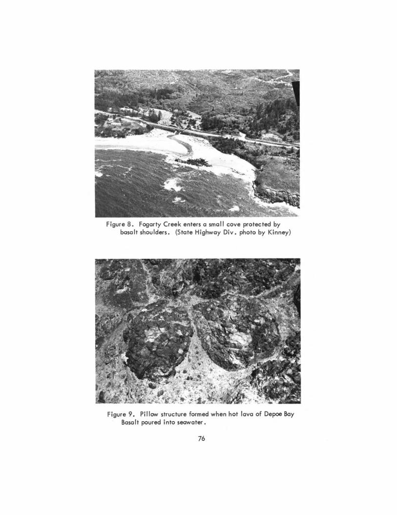
Figure 8. Fogarty Creek enters a small cove protected by bosalt shoulders. (State Highway Oi v . photo by Kinney)
Figure 9. Pillow structure formed when hot lava of Depoe Boy Basalt poured into seawater.
76
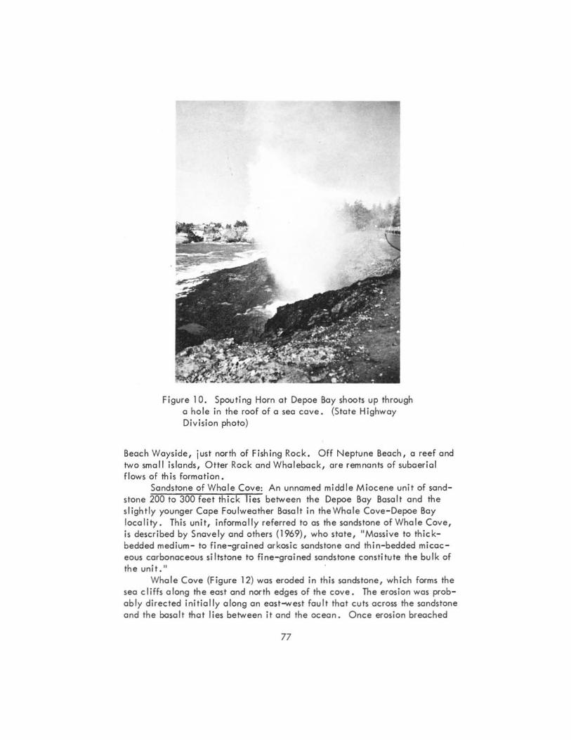
Figure 10. Spouting Horn at Depoe Bay shoots up through a hole in the roof of 0 sea cave. (State Highway Division photo)
Beach Ways ide, just north of Fishing Rock. Off Neptune Beach, a reef and two smoll islands, Otter Rock and Whaleback, are remnants of subaeri al flows of this format ion .
Sandstone of Whale Cove: An unnamed middle Miocene unit of sandstone 200 to 300 feet thick "lies between the Depoe Boy Bosalt and the slightly younger Cope Foulweather Basalt in theWhale Cove- Depoe Bay locality. This unit, informally referred to as the sandstone of Whale Cove, is described by Snavely and others (1969), who state, "Massive to thickbedded medium- to fine-grained arkos ic sandstone and thin- bedded micac eous carbonoceous siltstone to fine- grained sandstone constitute the bulk of the unit. It
Whale Cove (Figure 12) was eroded in this sandstone, which forms the sea cliffs along the east and north edges of the cove. The erosion was probably directed initially along an east_est fault that cuts across the sandstone and the basalt that lies between it and the ocean . Once erosion breached
77
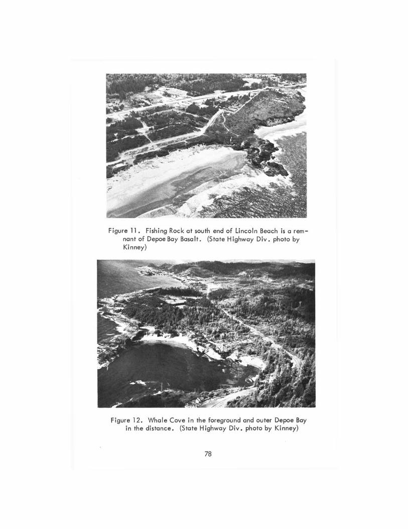
Figure 11. Fishing Rock at south end of Lincoln Beach is a remnant of Depoe Bay Basalt. (S tate Highway Div. photo by Kinney)
Figure 12. Whale Cove in the foreground and outer Depoe Boy in the distance. (State Highway Div. photo by Kinney)
78
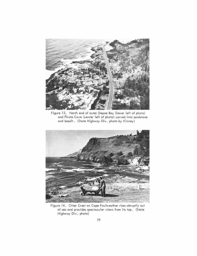
Figure 13 . North end of outer Depoe Bay (lower left of photo) and Pirate Cove (cen ter left of photo) carved into sandstone and basalt. (State Highway Div . photo by Kinney)
Figure 14 . O tter Crest on Cape Fou lweather rises abruptly out of sea and prov ides spectacular v iews from its top. (State Highway Div . photo)
79
())
o
NORTH HALF OF MAP
6 E[EHilH=iI::EH3:JH3:::lYE====:t:====:::l====~'MIL"
IQal Ifl Alluvium and estuary deposits
~ Beach, sandspits, and dunes
~ Marine terrace deposits
1m Cape Foulweather Basalt
~\t;;;-9.~i1 Sandstone of Whale Cove a Depoe Bay Basalt
EXPLANATION
I Ti-\llntrusive rocks
SOUTH HALF OF MAP
I· T~<:i<1 Astoria Formation
(,Tmi Nye Mudstone
I Toy: I Yaquina Formation'
I', Toa.-j Siltstone of Alsea
F)~rC.~)J Nestucca Formation
F:'rS[:·,l Siletz River Volcanic Series
Geologic map of coastal Lincoln County between Newport and Lincoln City. Adapted from maps by Snavely and Mac Leod, published in Schlicker and others (1973).
the wall of basalt, the cove was enlarged in the softer sandstone. Northtrending faults and fractures in the rock helped promote the cove's enlargement, and sea caves and small re-entrants formed along some of the fractures.
From Whale Cove, the sandstone formation extends northward beneath the terrace sandstone and is the rock in which the wide outer Depoe Bay was formed (Figures 12 and 13). It forms the sea cliffs at the north and south ends of this bay, and, as at Whale Cove, the sea cliffs are irregular and penetrated by sma II coves and sea caves.
Pirate Cove (Figure 13), a short distance north of Depoe Bay, is portly in the sandstone of Whale Cove, and the sea cliffs along the inner edges of the cove have caves, chasms, and other features characteristic of this sand- . stone. The sandstone ends just south of Boi ler Bay.
Cape Foulweather Basalt: The Cape Foulweather Basalt, named by Snavely and others (1973), is the younger of the two middle Miocene basalt units along this part of the Oregon Coast. It is more extensive than Depoe Bay Basalt and is the major contributor to the shore's irregularity. The unit includes several textural varieties of volcanic basalt but consists predominantly of breccia and water-laid fragmental debris (Snavely and others, 1969). It also contains massive subaerial flows and submarine pillow lavas. Volcanic necks and feeder dikes that cut through the layers of erupted rock indicate that the eruptions were from local centers. Particles that went into the ocean were reworked into poorly sorted and crudely stratified deposits that fringe the main body of erupted rock.
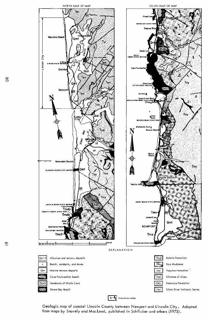
The main center of eruption of this basalt was at Cape Foulweather, where layers of basalt breccia and dense lava accumulated to a great thickness. The Cape, with cliffs and precipitous seaward slopes that rise to a height of 500 feet at Otter Crest (Figure 14) is one of the most ruggedly beautiful headlands on the Oregon Coast. From the viewpoint at Otter Crest, one can see miles of coastline to the south (Figure 4). North of Otter Crest the shoreline around the Cape is very irregular, with numerous small coves and smaller promontories (Figure 15).
The Cape Foulweather Basalt extends along the shore as far as Boiler Bay, and north of the Cape the rock consists mostly of fragmental types. It is the bedrock beneath the terrace along the shore between the Cape and Government Point (Figure 7). The basalt helps to enclose and protect Whale Cove, outer Depoe Bay, and Pirate Cove.
At Rocky Creek Wayside the Cape Fou Iweather Basalt is an unsorted and crudely stratified breccia (Figure 16) overlying dense flow basalt. The strata are fairly steeply inclined and are the accumulations of volcanic fragments and flows on the flank of a volcanic cone. North-trending fractures in the rock at this locality have directed the wave erosion that has shaped a picturesque setting of a chasm, sea caves, trenches, and isolated wavewashed rocks (Figure 17).
At Government Point the fragmental rock is roughly size-sorted and
82
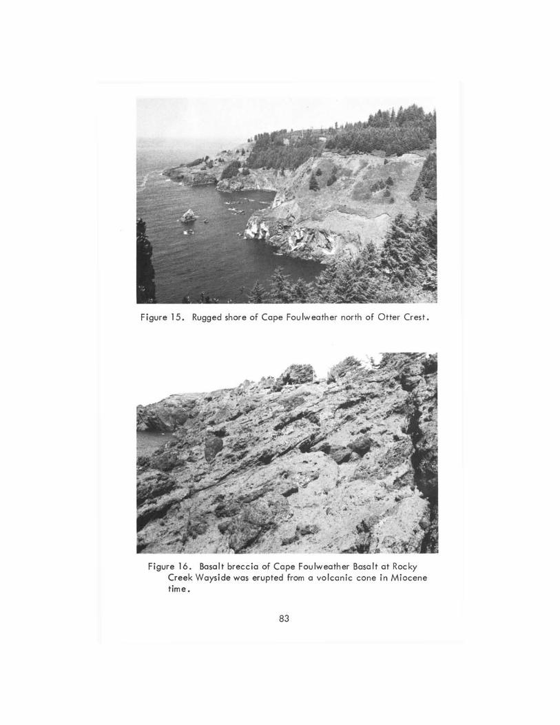
Figure 15. Rugged shore of Cape Foulweather north of Otter Crest.
Figure 16. Basalt breccio of Cope Foulweather Basolt ot Rocky Creek Wayside was erupted from a vo lcanic cone in Miocene time.
83
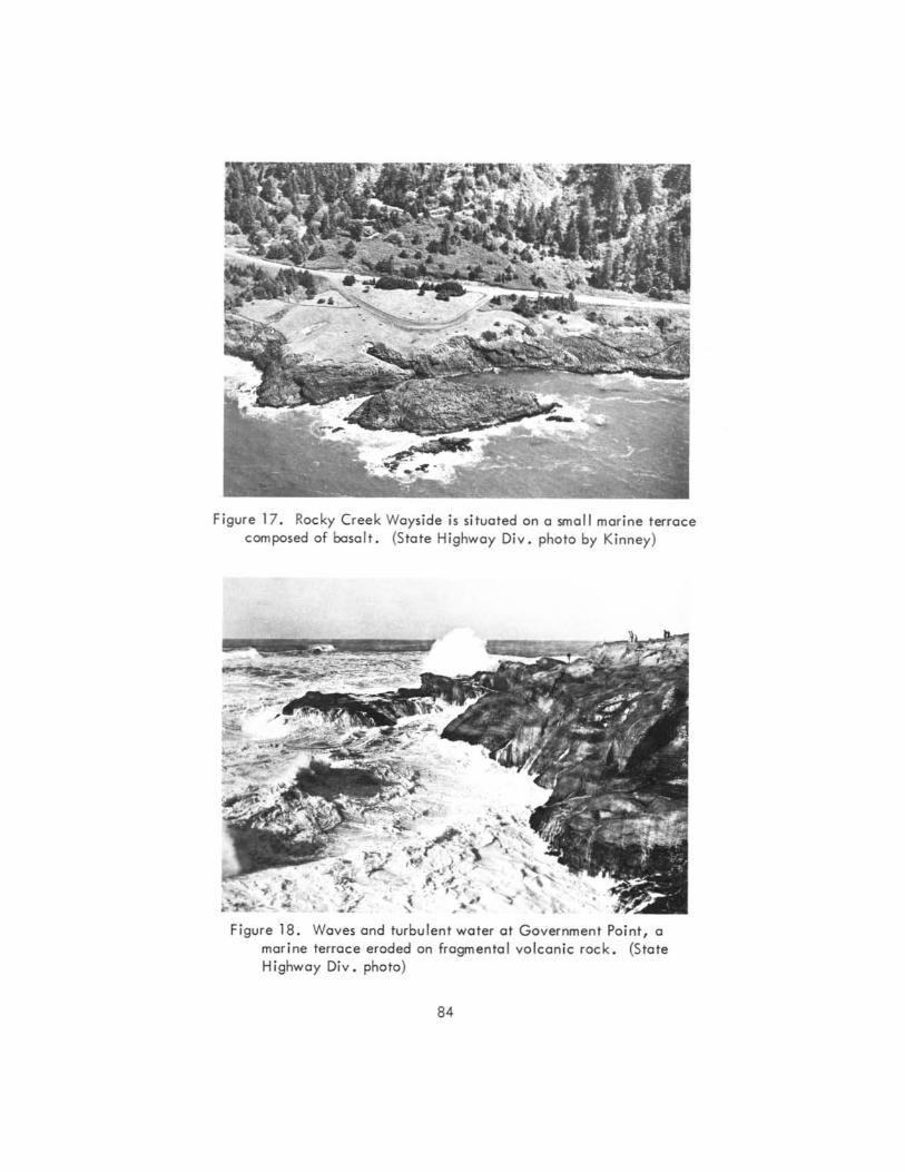
Figure 17. Rocky Creek Wayside is situated an a small marine terrace composed of basalt. {State Highway Oiv . phota by Kinney}
Figure 18. Waves and turbulent water at Gavernment Point, a morine terrace eroded on fragmental volcan ic rock. (State Highway Div . photo)
84
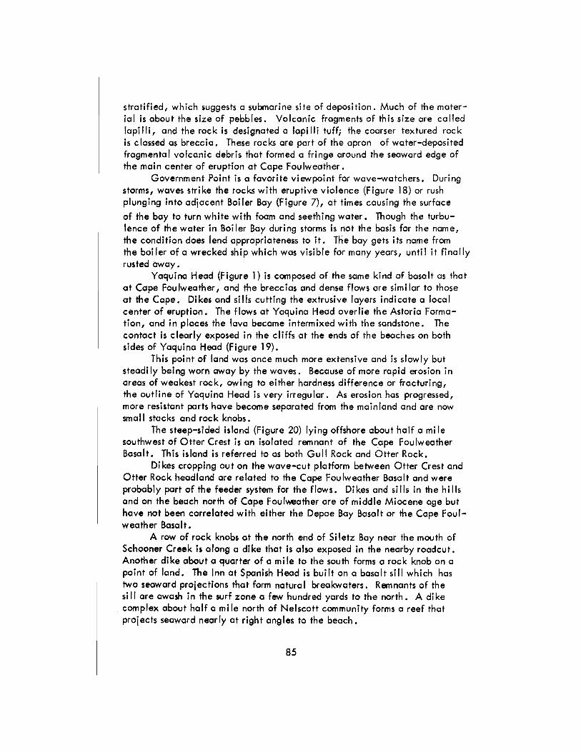
stratified, which suggests a submarine site of deposition. Much of the material is about the size of pebbles. Volcanic fragments of this size are called lapi IIi, and the rock is designated a lapi IIi tuff; the coarser textured rock is classed as breccia. These rocks are part of the apron of water-deposited fragmental volcanic debris that formed a fringe around the seaward edge of the main center of eruption at Cape Foulweather.
Government Point is a favorite viewpoint for wave-watchers. During storms, waves strike the rocks with eruptive violence (Figure 18) or rush plunging into adjacent Boiler Bay (Figure 7), at times causing the surface
of the bay to turn white with foam and seething water. Though the turbulence of the water in Boiler Boy during storms is not the basis for the name, the condition does lend appropriateness to it. The boy gets its name from the boiler of a wrecked ship which was visible for many years, until it finally rusted away.
Yaquina Head (Figure 1) is composed of the same kind of basalt as that at Cape Fou Iweather, and the brecc ias and dense flows are sim i lar to those at the Cape. Dikes and sills cutting the extrusive layers indicate a local center of eruption. The flows at Yaquina Head overlie the Astoria Formation, and in places the lava become intermixed with the sandstone. The contact is clearly exposed in the cliffs at the ends of the beaches on both sides of Yaquina Head (Figure 19).
This point of land was Once much more extensive and is slowly but steadi Iy bei ng worn away by the waves. Because of more rapid erosion in areas of weakest rock, owing to either hardness difference or fracturing, the outline of Yaquina Head is very irregular. As erosion has progressed, more resistant parts have become separated from the mainland and are now small stacks and rock knobs.
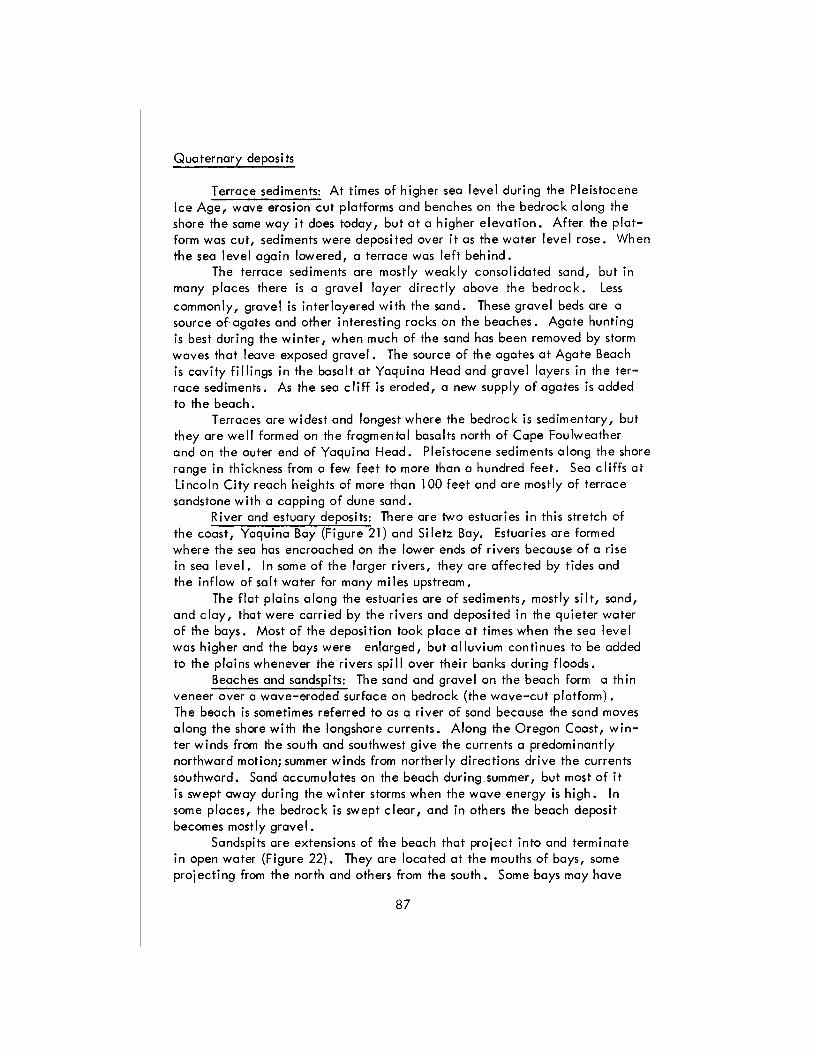
The steep-sided island (Figure 20) lying offshore about half a mi Ie southwest of Otter Crest is an isolated remnant of the Cape Foulweather Basalt. This island is referred to as both Gull Rock and Otter Rock.
Dikes cropping out on the wove-cut platform between Otter Crest and Otter Rock headland are related to the Cape Foulweather Basalt and were probably part of the feeder system for the flows. Dikes and sills in the hills and on the beach north of Cope Foulweather are of middle Miocene age but have not been correlated with either the Depoe Bay Basalt or the Cape Foulweather Basalt.
A row of rock knobs at the north end of Si letz Bay near the mouth of Schooner Creek is along a dike that is also exposed in the nearby roadcut. Another dike about a quarter of a mile to the south forms a rock knob on a point of land. The Inn at Spanish Head is built on a basalt sill which has two seaward projections that form natural breakwaters. Remnants of the si II are awash in the surf zone a few hundred yards to the north. A di ke complex about half a mile north of Nelscott community forms a reef that projects seaward nearly at right angles to the beach.
85
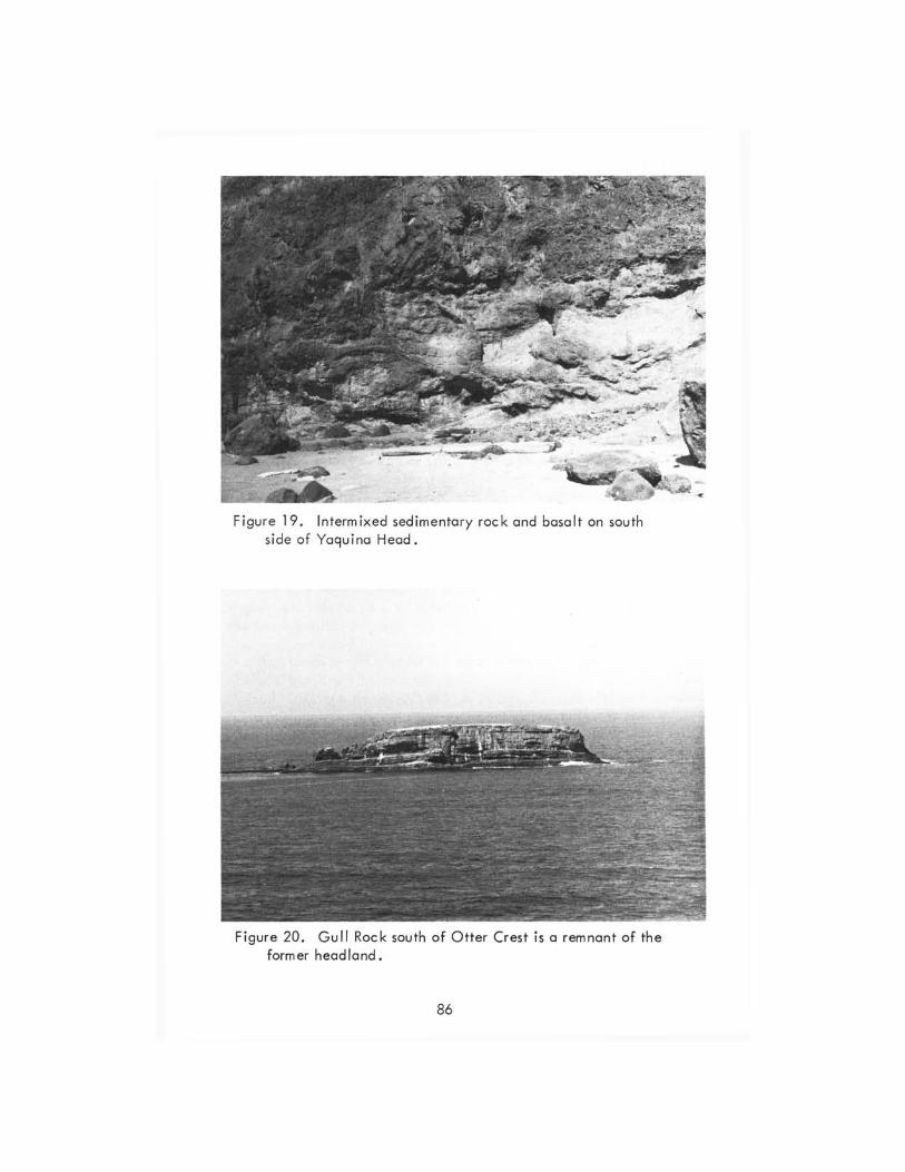
Figure 19. Intermixed sedimentary rock and basalt on south side of Yaquina Head.
Figure 20. Gull Rock south of Otter Crest is a remnant of the former headland.
86
Quaternary deposits
Terrace sediments: At times of higher sea level during the Pleistocene Ice Age, wave erosion cut platforms and benches on the bedrock along the shore the same way it does today, but at a higher elevation. After the platform was cut, sediments were deposited over it as the water level rose. When the sea level again lowered, a terrace was left behind.
The terrace sediments are mostly weakly consolidated sand, but in many places there is a gravel layer directly above the bedrock. Less commonly, gravel is interlayered with the sand. These gravel beds are a source of agates and other interesting rocks on the beaches. Agate hunting is best during the winter, when much of the sand has been removed by storm waves that leave exposed gravel. The source of the agates at Agate Beach is cavity fillings in the basalt at Yaquina Head and gravel layers in the terrace sediments. As the sea cliff is eroded, a new supply of agates is added to the beach.
Terraces are widest and longest where the bedrock is sedimentary, but they are well formed on the fragmental basalts north of Cape Foulweather and on the outer end of Yaquina Head. Pleistocene sediments along the shore range in thickness from a few feet to more than a hundred feet. Sea cliffs at Lincoln City reach heights of more than 100 feet and are mostly of terrace sandstone with a capping of dune sand.
River and estuary deposits: There are two estuaries in this stretch of the coast, Yoquina Bay (Figure 21) and Si letz Bay. Estuaries are formed where the sea has encroached on the lower ends of rivers because of a rise in sea level. In some of the larger rivers, they are affected by tides and the inflow of salt water for many miles upstream.
The flat plains along the estuaries are of sediments, mostly silt, sand, and clay, that were carried by the rivers and deposited in the quieter water of the bays. Most of the deposition took place at times when the sea level was higher and the bays were enlarged, but alluvium continues to be added to the plains whenever the rivers spill over their banks during floods.
Beaches and sandspits: The sand and gravel on the beach form a thin veneer over a wave-eroded surface on bedrock (the wave-cut platform) • The beach is sometimes referred to as a river of sand because the sand moves along the shore with the longshore currents. Along the Oregon Coast, winter winds from the south and southwest give the currents a predominantly northward motion; summer winds from northerly directions drive the currents southward. Sand accumulates on the beach during,summer, but most of it is swept away during the winter storms when the wave energy is high. In some places, the bedrock is swept clear, and in others the beach deposit becomes mostly gravel.
Sandspits are extensions of the beach that project into and terminate in open water (Figure 22). They are located at the mouths of bays, some proj ecti ng from the north and others from the south. Some bays may have
87
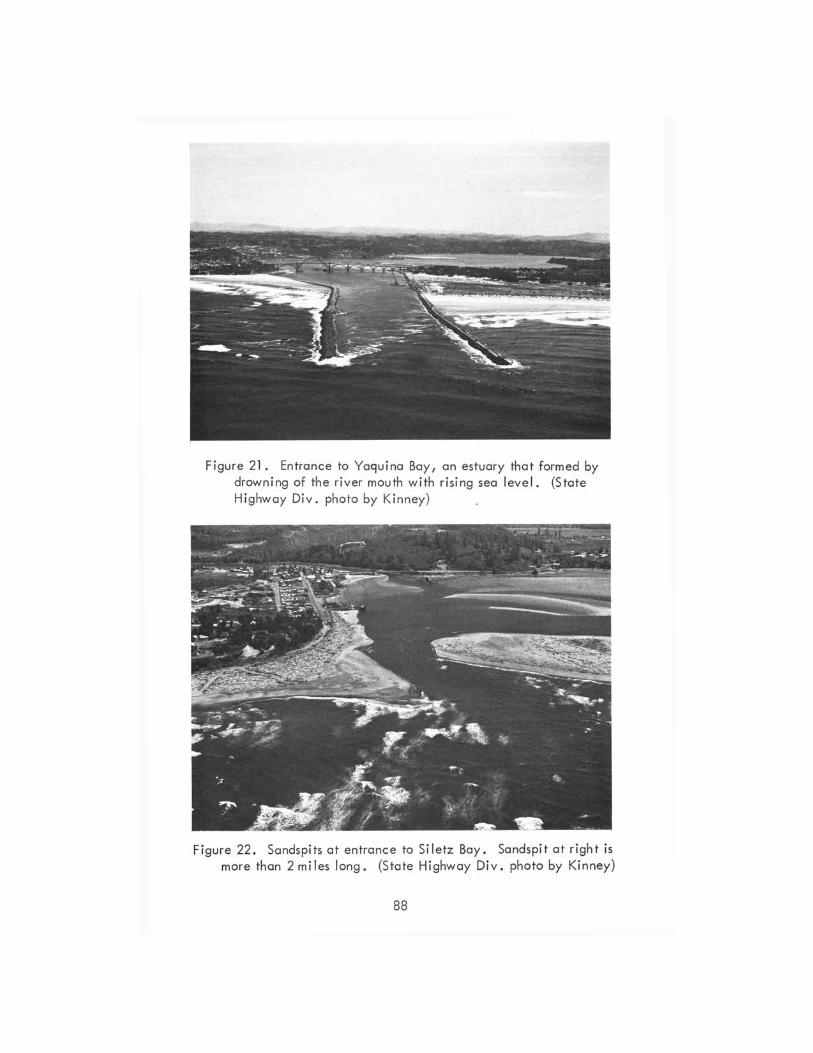
Figure 21 . Entrance to Yaguina Bay, an estuary that formed by drowning of the river mouth with rising sea level. (State Highway Div. photo by Kinney )
Figure 22. Sandspits at entrance to Siletz Bay. Sandspit at r ight is more than 2 mi les long. (State Highway Div. photo by Kinney)
88
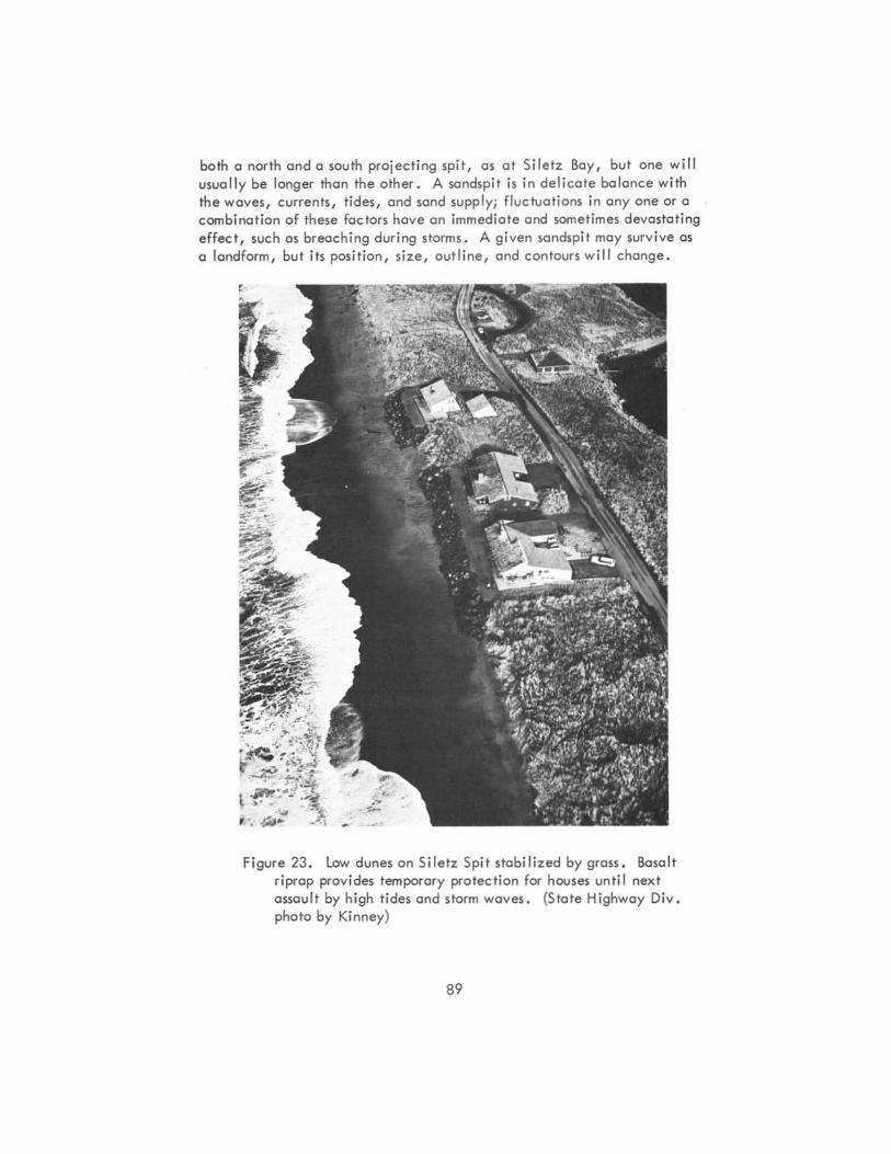
both a north and a south praject ing spit, as at Siletz Say, but one will usua l ly be longer than the other. A sandspit is in delicote balance with the waves, currents, tides, and sand supply; fluctuations in anyone or a combinat ion of these factors have an immediate and sometimes devastating effect, such as breaching during storms. A given sandspit may surv ive as a landform, but its pos it ion, size, outline, and contours will change.
4 ' . ~ ... Figure 23. low dunes on Siletz Spit stabilized by grass. Basalt
riprap prov ides temporary protection for houses until next assault by high t ides and storm waves. (State Highway Oiv. photo by Kinney)
89
Sand dunes: Because most of the shore between Newport and Lincoln City has a sea cliff along it, preventing sand from blowing inland from the beach, there are few recent dunes. Old Pleistocene-age dunes composed
of brownish-yellow sand are situated on the marine terrace at a number of places between Newport and northern Lincoln City. The old dunes are stabi lized by soi I and vegetation, but where exposed they are subject to erosion. They are visible in the higher sea cliffs, in highway cuts, and in excavations.
Dunes along the Si letz sandspit are the most recently active, but over most of the sandspit they have been stabilized with European Beach grass (Figure 23). On the seaward side at the end of the spit, sand is still being moved by the wind. Erosion by waves during storms and high tides of winter are constantly wearing away the outer margin of this spit, endangering houses built too near the edge and requiring the placement of rock (riprap) to retard the erosive undermining of the structures.
Devi Is lake, the on Iy large lake on this part of the Oregon coast, owes its origin to drowning of the lower part of a stream valley and blocking of the stream's mouth by dunes and beach deposits. Since the volume of water flowing in 0 River is not sufficient to keep the bottom of the river channel below sea level, a fresh-water lake results rather than a salt-water estuary.
Bibliography
Schlicker, H. G., Deacon, R. J., Olcott, G. W., and Beauli.eu, J. D., 1973, Environmental geology of lincoln County, Oregon: Oregon Dept. Geol. and Mineral Indus. Bull. 74, 164 p.
Snavely, P. D., Jr., and Macleod, N. 5.,1971, Visitor's guide to the geology of the coastal area near Beverly Beach State Park, Oregon: Ore Bin, v. 33, no. 5, p. 85-105.
Snavely, P. D., Jr., Macleod, N. 5., and Rau, W. W., 1969, Geology of the Newport area,Oregon: Ore Bin, v. 31, nos. 2 and 3, p. 25-71.
Snavely, P. D., Jr., Macleod, N. 5., and Wagner, H. C., 1973, Miocene tholeiitic basalts of coastal Oregon and Washington and their rela-tions to coeval basalts of the Columbia Plateau: Geol. Soc. America Bull., v. 84, no. 2, p. 387-424.
Snavely, P. D., Jr., Rau, W. W., and Wagner, H. C., 1964, Miocene stratigraphy of the Yaquina Bay area: Ore Bin, v. 26, no. 8, p. 133-151.
Snavely, P. D., Jr., Wagner, H. C., and Macleod, N. 5.,1965, Preliminary data on compositional variations of Tertiary volcanic rocks in the central part of the Oregon Coast Range: Ore Bin, v. 27, no. 6, p. 101-116.
* * * * *
90
OTHER COASTAL LANDFORMS ARTICLES AVAILABLE
Among the many articles previously published in The ORE BIN on landforms and geology of the coastal areas of Oregon are the following, copies of which are avai lable at Department offices for 25/ each:
lund, Ernest H., Coastal landforms between Florence and Yachats, Oregon: Ore Bin, v. 33, no. 2, p. 21-44, Feb. 1971. , Coastal landforms between Yachats and Newport, Oregon: Ore Bin,
--v. 34, no. 5, p. 73-92, May 1972. , Coastal landforms between Ti IIamook Bay and the Columbia River,
--Oregon: Ore Bin, v. 34, no. 11, p. 173-194, Nov. 1972. , Oregon coastal dunes between Coos Bay and Sea Lion Point: Ore
--Bin, v. 35, no. 5, p. 73-92, May 1973. , landforms along the coast of southern Coos County, Oregon: Ore
--Bin, v. 35, no. 12, p. 189-210, Dec. 1973. Hunter, R. E., Clifton, H. E., and Phillips, R. l., Geologyofthestacks
and reefs off the southern Oregon coast: Ore Bin, v. 32, no. 10, p. 185-201, October 1970.
Snavely, P. D., Jr., and Macleod, N. S., Visitor's guide to the geology of the coastal area near Beverly Beach State Park, Oregon: Ore Bin, v. 33, no. 5, p. 85-1 05, May 1 971 •
* * * * *
BUll RUN WATERSHED GEOLOGY PUBLISHED
"Geologic Hazards of the Bull Run Watershed; Multnomah and Clackamas Counties, Oregon" is the latest of the Department's bulletins dealing with environmental geology. The author is John D. Beaulieu, Department stratigrapher.
The Bull Run watershed, situated at the foot of Mount Hood in the Western Cascades, is Portland's sole source of water and is an excellent timber-producing area. As part of a comprehensive land management program, the geologic hazards study was initiated to provide basic data regarding the capabi lities of the land and the types of natural hazards threatening water quality. The bulletin discusses geologic units, geologic hazards, runoff, and historic landslides.
Bulletin 82 has 86 pages, 71 photographs, 14 drafted figures, 6 tables, and two maps on a scale of 2 inches to a mile. The bulletin can be obtained from the Cregon Department of Geo logy and Mi nera I I ndustri es at its offi ces in Portland, Baker, and Grants Pass. Price is $5.00.
* * * * *
91
GEOTHERMAL DEVELOPMENTS
Auction date set for Vale KGRA
The first competitive Federal auction for geothermal resources in Oregon has been scheduled for 10:00 a.m. June 21. The auction will be for a 1,347.17 acre leasing unit near Vale. Sealed bids will be accepted for the unit until sale time at the Bureau of Land Management office, 729 N. E. Oregon Street, P.O. Box 2965, Portland, Oregon 97208.
Information on specific detai Is and terms of the offering can be obtained at the BLM office.
Addition to Vale KGRA
An additional area of 11,535.27 acres has been added to the Vale Hot Springs Known Geothermal Resource Area. Location is as follows:
T. 18 5., R. 45 E., Sec. 34: a II T. 195., R. 45 E., Sec. 2-4, 9-15, 23-26, 36 inclusive T. 1 9 5 ., R. 36 E., Sec. 1 9, 30: a II
New KGRA defined at Belknap-Foley Hot Springs
An area of 5,066.21 acres adjacent to Belknap and Foley Hot Springs has been identified as a Known Geothermal Resource Area by the Conservation Division of the U.S. Geological Survey. Location is as follows:
T. 1 6 S., R. 6 E., S ecs. 14, 20-23, 26, 28, 29: a II
New KGRA defined at McCredie Hot Springs
An area of 3,658.60 acres adjacent to McCredie Hot Springs has been identified as a KGRA by the Conservation Division of the U.S. Geological Survey. Location is as follows:
T. 21 S., R. 4 E., Secs. 25, 26, 35, 36: all T. 225., R. 4 E., Sec. 1: all T. 21 5., R. 5 E., Sec. 31: all
Geothermal leases are for 10 years, with provisions for renewal to a maximum of 40 years. "Diligent exploration" is required and a rental fee of not less than $2 an acre per year wi II be charged prior to production. After five years, rentals will go up $1 an acre per year through the tenth year.
The Geological Survey identified 84,000 acres of Oregon land in seven areas as Known Geothermal Resource Areas (KGRA). Since January 1, there have been 693 applications filed for leases in Oregon for approximately 1.5 million acres of Federal land not previously identified for its geothermal potential.
92

AVAILABLE PUBLICATIONS
(Pleole Include remittance wltn orct.; pottoge fr ... All soles cre finol ~ no returns. Upon request, 0 complete IlIi of Depcrtment p.lblicotlOnJ, Including out-of-plnt, will be moiled)
oflt .. 1 plonlln low. Columblo RI .... creo, r .... . 19040: Mill. .50.040 26. Soil: Its crlgln, destruction, p'eservalloo, 194.4: Twenhofel. • • • • 0.045 33. IUbllO{J'Clphy (lsi IUppl. ) geology ond mlnerol resoo.rces of Oregon, 19-47: Allen . 1 .00 35. Geology of 001101 ond Vol .. tz quo«ongles, Oregon, re ... . 1963: Baldwin . • • 3.00 36. f/ap«1on T.tfcry foromlnlfera: Cmman, St_crt & SI_crl . "'01. I 51.00; '101. 2 1.25 39. Geology and mlneroll%Olloo of Morning mine region, 1948: Allen ond Thayer 1.00 46. Ferruginous bcaI)tlte depoalts, Solem Hili" 1956: Corcoran ond lJbbey . • • 1.25 049. loGe mines, Granite mining dhtrlct, Gront County, Oregon, 1959: Koch 1.00 52 . Chromlte In southweslern Oregon, 1961: Ramp • • • • • • • . •• 3.50 57 . Luna' Geologlcol field Conf. guidebook, 1965: Pet.son ond Groh, editors. 3.50 58. Geology of the Supl .. ~b ... creo, Oregon, 1965: Dickl,..an ond Vigrou. . 5.00 60. Engine.iog geology of Tuolotln Volley region, 1967: Schlicker ond Oeocon . 5 .00 61 . Gold and lil ... er In Oregon, 1968: Broola. ond Romp . • 5.00 62. Andesite Conference Guidebook, 1968: Ool~ . • • • • . . • • •• 3.SO 64 . Geology, mlnerol, ondwoterresoo.rcesofOregon, 1969 • • • • • •• 1.50 66 . Geology, mlnerol resources of Klomath & Loke counties, 1970: Peter1of<l & Mcintyre 3 .75 67 . Bibliography (04th wppl.) geology ond mlnerol Industries, 1970: Roberh 2 .00 68 . The Se ... enteenth Blennlol Report of the State Geologl$I, 1968-1970. 1.00 69 . GeolOil)l of 1M Southwestern Oregon COOIt, 1971: Doll • • • • • 3.75 10 . Geologic formali_ofWestern Oregon, 1971: BeoulJeu • • • • • 2 .00 71. Geology of,elected 10\10 lubes In the Bend creo, 1971: Gr .. tey. . . 2.50 n. Geology of Mitchell Quo«ongle, Wh .. ler County, 1972: Oles ond Eniowl 3.00 73. Geologic formoti_ of Eastern Oregon, 1m: Beo.olleu • • . • • • 2.00 704. Geology of cOOItal region, Tlltomook Clotsop Counties, 19n: Schlick. & other, 7.50 75 . Geology, mlnerol r_cesof DouglOlCounty, 1m: Romp . • • • • • • 3.00 76. Elgh,"nth Bienniol Report of the Oeporlmenl, 197()..1972 . • • . • . • • 1.00 77 . Geologic field trips in northern Oregon and southern WoihiflAton, 1973 • •• 5.00 78. Bibliography (5th ""ppl.) geology ond miowol indontrle., 1973: Roberts ond other, 3.00 79. EnvirOl"lMntal geology Inlond Tiliomook C!alsop Counties, 1973: Beoulieu. 6.00 80. Geology ond mlowol resourc" of COOl County, 1973: aolct..lin and o"'er, 5.00 81. Environmental geology of Uncoln County, 1973: Schlicker ond others . . . 7.50 82. Geol . hozards of Bull Run Wot""ed, Mull. CIocIa:wnoI Cos., 1974: BecIU lieu 5 .00 83 . Eoc_strotlgrophy of southwes*n Oregon, 19704: Baldwin . . . • . in P'ep . 804. Envirormental geology of weslern Linn Co., 1974: Beoulleu ond other,. . in P'-85. Envirormental geology of COCIltallone Co., 19704: Schlicker oncl others . in P'ep .
GEOLOGIC MAPS Geologic map Of Qregon west of 121,t meridian, 1961: Wells and Peck • • . • Geologic mop of Oregon (12" x 9"), 1969: Wolker ond King . • • •• •• Geologic map of Albony quo«-ongle, Oregon, 1953: AI"SOI'! (0110 in Bulletin 37) Geologic mop of Galice quo«ongle, Oregon, 19.53, Well. and Wolk. . • Geologic mop of Lebanon quo«ongle, Oregon, 19.56: Allison and fel". • • • • Geologic map of Bend quocWongle, ond portion of High COKade Mlns., 19.57: Wllllo~ GMS~I: Geologic map of the Sporta quo«angle, Oregon, 1962: Prostko • • •• GMS ~2: Geologic map, Mitchell Butte quod., Oregon: 1962, CorcOl'onondoth~. GMS ~3: Preliminary geologic mop, Durk .. quo«ongle, Oregan, 1967: Prostka • • • GMS-4: Gravity maps of Oregon, onshore & offshore, 1967: Berg and others
bald only In let] flot 52.00; folded In envelope GMS ~S: Geology of the Pow.,.. quo«ongle, 1971, aoldwln ond H_
2 . \5 0.25 0 .50 1.00 0 .75 1.00 I.,., I.,., I .,.,
2.25 1.50
GMS~: Prelim. report, geology of port of Snoke River Conyon, 1974: Vollier . In P'ep.
[Continued on back cover]
The ORE BIN 1 069 Sto~ omu Bldg., Portland, Or~ 9nol The Ore Bin POSTMASTER: Return postage g~anteed .
~ .
A vailable Public:atiant, Continued :
SHORT PAPERS Is. ROd;ooc:tlve mineralt prospec:tan .... auld know, 1955: White and Sc:hafer 19. Brlc:k and tile lnduttry in Oregan, 19-49: Allen and Mo$On 21. Lig,lweig,t aggregate induttry In Oregon, 1951: Ma$OO . . 2-4. The Almeda mine, Josephine County, Oregon, 1967, Libbey
MISCELLANEOUS PAPERS I. betc:riptlon of $OITIe "regan roc:lu and min..-a]" 195C). Dole. . . . . • . 2. Or~ mi~al deposits. mop (22 It 3-4 Inc:hes) and key (repinted 1973): Moton . -4. Rules and regulations for C:OOS¥volion of oil and naturol p (rev. 1962) 5. Oregon'l gold plaun (reprinh), 195-4 . . . . . • . . . • . 6. Oil and (101 exploration in Oregon, rev. 1965: SI_art ond N_lon . 7. Bibliography of th_ on Oregon geology, 1959: Sc:hlic:ker . . . . 7. (Suppl."enl) Bibliography of th_, 195910 Dec:. 31, 1965: Rob.h 8. AvoJloble well reeordi of oil and got exploration In Oregon, rev. 19/1l N_ton
11. A c:allec:tian of artlc:let on meteorltet, 19/18 (reprinh from The ORE BIN) 12. Index 10 publi~ed geologic: mopping in Or~, 1968: Corc:oran 13. Index 10 The ORE BIN, 1950-1969, 1970: L_il 1-4. Thermol tpringl and weill, 1970: Bowen and Peterton 15. Quic:ksilver deposi~ in Or-aon, 1971 : arooks 16. MOICIic: of Or~ from ERTS-l imog.y, 1973:
OIL AND GAS INVESTIGATIONS SERIES 1. Petroleum geology, wettern Snoke River basin, 1963: N_ton and C«c:aron . 2. Subwrfoc:e geology, lower Columbia anc!Wlllomelle baJiOl, 1969: N_lon . 3 . Prelim. identific:otions of forominirera, General Petroleum Long Bell no. I well -4. Prelim. Identific:otions of foromlnlfera, E. M. Warren Coos Co. 1-7 well : Rou
MISCELLANEOUS PUBLICATIONS
.s0.30
.0.20
.0.25 · 2.00
. 0.-40
. 0.75 · 1.00 .0.25 .I.SO .0.50 .0.50
0.50 · 1.00 .0.25 .0.30 · 1.00 .1.00 . 2.00
2.50 2.50 1.00 1.00
londformlof Oregon: a phYliographlc: 'kelc:h (17" It 22M), 19-41 . . . . • . . .0.25 Geologic: lime c:hart for Oregan, 1961 . • . . . .•. free Pastc:ord - geology of Oregon, in c:alor . . . . . lot' .ac:h; 3 - 25$; 7 - 5t¥; 15 - 1.00 Oregan bow mop (22 It 30 irw:hel) . . • . . . . .. .......0.50 Mini"" c:laiml (State lowl governing quartz and ploc:er c:laiml) .......0.50 The ORE BIN - AnnuallUbKriplion. . . . . . . . • (S.5.OO rex- 3 )0. ) 2.00
Available bac:k illUes, eoc:h , . . • . • . . . . . . 0.25 Acc:umulated index -I" MiK . Paper 13