Assessment of Unionid Refuges Procedures (draft).
19
Assessment of Unionid Refuges Procedures (draft)
-
Upload
paul-gregory -
Category
Documents
-
view
218 -
download
0
Transcript of Assessment of Unionid Refuges Procedures (draft).

Assessment of Unionid Refuges Procedures (draft)

Research questions
1. What environmental parameters are specific to unionid refuges in the lower Great Lakes?
2. What are the diversity and densities of unionid populations in these refuges?

Methods
• The 23 known refuges in Lake St. Clair and Lake Erie will be surveyed.
• Need to divide by state groups, and have a leader (or leaders) for each group

PA – 2 - Presque Isle, and Conneaut Cr??
NY – 2+ - Cattaraugus Cr, Tonawanda Cr, + Ontario refuges
site refuge!
Michigan – 4 - Lake St. Clair, Monroe PP, Luna Pier, Indian Creek Bay
Ohio – 15 – (start – Bayshore, finish - Grand R Mouth)

Organization• 2-3 leaders (PI) per each state
– MI – Dave, Matt (DTE), Don – OH – Ferenc, Mike, Bob– PA – Mary, Beth– NY – Lyuba, Sasha
• the leaders & PI will be responsible for developing methods and sampling protocols, permissions
• the leaders (and their students) will participate in surveys in other states

Organization• Draft protocols will be sent to all participants for
discussion in March– sampling protocol– sheet for biological data collection– sheet for abiotic data collection– sheet for genetic tissue collection
• All protocols/sheets will be developed by June• Additional meeting by smaller group to finalize the
methods (May)• Training joint sampling on 2-3 different coastal and
river sites (Maumee, Monroe PP, Ottawa, Sandusky?) in mid to late June
Organization• The join sampling will finalize the
methods/protocols/data collection sheets• Each team should make sampling schedule
and send to everyone• Sampling – July-August (June-September)?• Additional sampling will be done in summer
2012 (on predicted sites in Lake Erie & Ontario)

Coastal refuges surveys: Methods
1. Timed-search will be conducted at each site to determine the presence of unionids. – Time search will be proportional to the area of the site (same TS per
site (hectare ?)– Every team will make maps and determine the sites, and provide the
number of sampling sites – If a live mussel found, mark with the stake for future transect– if no mussels found the time search, the site will be ab.
2. Quantitative search of the substrate either visually or by touch or by touch everywhere?– transects run parallel to the shore (following depths lines?)– snorkeling in shallow water (using rakes?), and SCUBA etc in deeper
water– need to cooperate on diving procedures and policies

Coastal refuges surveys: Methods
– A metal rebar stake will then mark the position of a unionid and a 4.55 m line will be attached to the stake.
– Using the 4.55 m line as a guide, a search for unionids will be conducted by swimming in concentric circles around the stake in an inward direction until the entire area (65 m2) has been covered
– 1 diver, 1 recorder 4.55 m
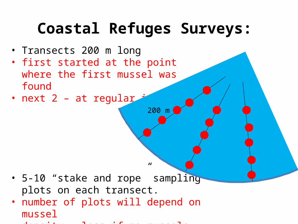
Coastal Refuges Surveys: • Transects 200 m long • first started at the point where the first
mussel was found• next 2 – at regular intervals?
• 5-10 “stake and rope” sampling plots on each transect.
• number of plots will depend on mussel density – less if no mussels found later?
200 m

Divers??
• CMU – 4• BSC – 3• Kent – 1• PA Cons – 5• DTE – 3• Total – 15?• Diving policies

Coastal Refuges Surveys:
• To reveal successful reproduction and recruitment, we will excavate and sift through a sieve at least 10 0.25 m2 quadrats
• only in areas where a sufficient density of mussels is found (>0.1 m-2).
• sieve size 6.4 mm (1/4 inch) and ½ inch (will check) • need to buy similar sifts for each crew

Refuge Assessment Surveys: Seiche method (Todd)
• We will use time-searches and, if possible, area-searches during the time-restricted seiche events
• As soon as the event happens (or be predicted), a group of available participants will collect for sampling
• Sampling Protocol is needed - Todd• Need to buy/rent snowshoes?

Refuge Assessment Surveys: coastal rivers
• In rivers, we will do targeted surveys and collections for species in common with those collected in nearby coastal refuges.
• Timed-search• Will do join sampling on 1-2 rivers to establish common
protocol• Need to record timed-search effort• Need to decide if we collect only common or all species• Need to develop methods for unified full surveys where
needed (on un- or under-surveyed unionid populations)

Refuge Assessment Surveys: biological data
Unionids:• all live mussels found will be identified to species • sexed where possible• shell lengths and weight will be measured in the field. • females will be checked to determine if they are gravid (brooding
larvae) • evidence of past dreissenid infestation (byssal threat cover) will be
documented• animals will be returned to the water alive (with any infesting
dreissenid mussel removed), and placed carefully into the substrate from which they were taken.
Dreissenid mussels infesting the unionid shells:• will be removed from the shell and weighed,• labeled (with unio species and length, transect & plot #) and send (in
alcohol) to Buffalo State (Lyuba & Sasha)• should we record Dreissena densities?? categorical??

Refuge Assessment Surveys: genetic analysis
• David will develop methods and protocol• his students will be at each sampling event to collect the data

Refuge Assessment Surveys: Abiotic data
• Abiotic parameters that we will record from all sites: – location (GPS, name of the bay, road, etc) – dominant substrate type (at each plot, in %) (Bedrock; Large
Boulders >45 cm; Boulders >25 - 45 cm; Cobble >6 - 25 cm; Gravel >6 - 60 mm; Sand 0.06 - 6 mm; Mud/Silt <0.06 mm)
– depths (at each plot), – water temperature, pH, conductivity, turbidity (at 3 points
at each site) – depth of soft sediments (measure with a stick, device? - at 3
points at each site or at each point, depending on complexity of measurement)
– % macrophyte overgrowth (visual) submerged and emergent (species)

Coastal Refuge Surveys: current threats
• record anything visible• sediment disturbance (filling, grading, removal of
vegetation, building construction etc), • pollution, • watershed development

Refuge Assessment Surveys: Abiotic data
• At each site:• make and install Jessica’s device to measure water
levels and variation in water levels, • PVC settlement plates (6 per each refuge) installed in
May or June until September-October