Assessment of Land and Groundwater Contamination … · Assessment of Land and Groundwater...
75
Appendix C Assessment of Land and Groundwater Contamination Effects: Addendum Technical Report 23a
Transcript of Assessment of Land and Groundwater Contamination … · Assessment of Land and Groundwater...

Appendix C
Assessment of Land and Groundwater Contamination Effects: Addendum
Technical Report 23a
Addendum Technical Report 23a: Assessment of Land and Groundwater Contamination Effects
Prepared for New Zealand Transport Agency
By Beca Ltd
1 May 2013

Assessment of Land and Groundwater Contamination Effects M2PP-AEE-RPT-EN-CL-079 1 May 2013 // Page i
Revision History
Revision Nº Prepared By Description Date
A Genevieve Smith Draft for review
Document Acceptance
Action Name Signed Date
Prepared by Genevieve Smith
Reviewed by
Kerry Laing
Approved by
Graham Spargo
on behalf of
Beca Ltd

Assessment of Land and Groundwater Contamination Effects M2PP-AEE-RPT-EN-CL-079 1 May 2013 // Page ii
Contents
Executive summary ....................................................................................... 1
1 Introduction............................................................................................ 4
1.1 Purpose and scope ......................................................................................... 5
1.2 Report structure .............................................................................................. 5
2 Existing environment .............................................................................. 7
2.1 Geology ......................................................................................................... 7
2.2 Hydrology ....................................................................................................... 7
2.3 Hydrogeology ................................................................................................. 8
3 Assessment criteria ................................................................................ 9
3.1 Introduction .................................................................................................... 9
3.2 Assessment of environmental risk ................................................................... 10
3.3 Assessment of human health risk .................................................................... 12
3.4 Assessment of regional resource consent requirements for contaminated sites .... 13
3.5 Assessment of soils for reuse or disposal ......................................................... 14
4 Methodology ........................................................................................ 17
4.1 Investigation activities .................................................................................... 17
4.2 Test pits ....................................................................................................... 17
4.3 Hand augers ................................................................................................. 17
4.4 Sampling and monitoring ................................................................................ 17
5 Sector 1 ............................................................................................... 19
5.1 Sector description ......................................................................................... 19
5.2 Investigation activities .................................................................................... 19
5.3 Soil investigation findings ............................................................................... 21
5.4 Discussion .................................................................................................... 23
5.5 Summary of effects and proposed mitigation .................................................... 25
5.6 Conclusions .................................................................................................. 26
6 Sector 2 ............................................................................................... 28
6.1 Sector description ......................................................................................... 28
6.2 Investigation activities and methodology .......................................................... 28
6.3 Soil investigation findings ............................................................................... 31
6.4 Discussion .................................................................................................... 34
6.5 Summary of effects and proposed mitigation .................................................... 38

Assessment of Land and Groundwater Contamination Effects M2PP-AEE-RPT-EN-CL-079 1 May 2013 // Page iii
6.6 Conclusions .................................................................................................. 39
7 Sector 3 ............................................................................................... 41
7.1 Sector Description ......................................................................................... 41
7.2 Investigation Activities and Methodology .......................................................... 41
7.3 Investigation findings ..................................................................................... 42
7.4 Discussion .................................................................................................... 42
7.5 Summary of effects and proposed mitigation .................................................... 44
7.6 Conclusions .................................................................................................. 45
8 Sector 4 ............................................................................................... 46
8.1 Sector Description ......................................................................................... 46
8.2 Investigation Activities .................................................................................... 46
9 Summary of Proposed Mitigation Measures............................................. 47
10 Summary Conclusions .......................................................................... 49
10.1 Investigation Summary .................................................................................. 49
10.2 Soils ............................................................................................................ 49
10.3 Assessment of Environmental Effects and Mitigation ......................................... 51
Bibliography ............................................................................................... 53
List of Appendices
Appendix A – Regulatory Framework
Appendix B – Investigation Location Maps
Appendix C – Sector 1: Laboratory Testing Summary Sheets, Logs and Investigation Summary
Appendix D – Sector 2: Laboratory Testing Summary Sheets, Logs and Investigation Summary
Appendix E – Sector 3: Otaihanga Project Yard Logs
Appendix F – Maps of Contamination Guideline Exceedance Locations
Appendix G - Hills Laboratory Results
Appendix H Chain of Custody Forms
Appendix I M2PP-AEE-RPT-EN-CL-023 MacKays to Peka Peka, Kāpiti Coast – Contamination Desk Study, June 2011.

Assessment of Land and Groundwater Contamination Effects M2PP-AEE-RPT-EN-CL-079 1 May 2013 // Page 1
Executive summary
Introduction
The MacKays to Peka Peka Expressway route (‘the Expressway’) has been identified as one of eight sections within the Wellington Northern Corridor (SH1 from Levin to the Wellington Airport) which is an identified “Road of National Significance” (RoNS). The MacKays to Peka Peka Expressway Project (‘the Project’) is to be lodged with the Environmental Protection Agency (EPA) as a Proposal of National Significance.
Assessment of Land and Groundwater Contamination Effects, Technical Report 23 was prepared as part of the resource consent application for the Project. This report identified additional areas of potentially contaminated land that required further investigation. This addendum report presents the findings and assessment of the results of the investigation of the additional sites. The purpose of this contamination assessment is to identify and characterise areas of soil contamination along the route of the Expressway and to determine the potential environmental effects of the Project. This has involved the assessment of soil contamination, human health risk to the general public and construction workers, resource consent requirements and soil classification for reuse or disposal.
The Project has been divided into four sectors which broadly define the urban and rural areas along the route of the Expressway.
The general geological sequence beneath the Project area is Recent alluvial deposits (sands and gravels) with superimposed areas of swamps and sand dunes. Significant peat deposits are associated with the swamps. The alluvial deposits are underlain by greywacke basement rocks. A shallow unconfined aquifer extends to a depth of approximately 30m. This aquifer supplies water for potable and irrigation use.
Criteria have been adopted for assessment of resource consent requirements, human health risks and soil classification. In the Wellington Region, discharge of contaminants is controlled by the Regional Plan for the Discharges to Land for the Wellington Region, 1999 (Discharges to Land Plan).
For human health risk assessment, the Resource Management (National Environmental Standard for Assessing and Managing Contaminants in Soil to Protect Human Health) Regulations (NES), 2011 have been used. For soil classification, MfE and regional guidance has been used.
A number of intrusive investigations have been carried out comprising test pits and hand augers. Soils have been sampled for chemical laboratory analyses for a broad suite of organic and inorganic determinands.
Sector 1

Assessment of Land and Groundwater Contamination Effects M2PP-AEE-RPT-EN-CL-079 1 May 2013 // Page 2
The route in this sector passes through the corner of Queen Elizabeth Park and follows approximately the existing Western Link Road (WLR) Designation through Raumati towards the Kāpiti Road intersection.
The findings of the intrusive investigation of two sites in Sector 1 reveal that fill, where identified, consisted of reworked natural materials (organic sandy silts). Waste materials in the fill comprised timber, asphalt, brick, glass, geotextile, ceramic, concrete, plastic, metal items and household refuse
Results of chemical laboratory analyses of soils indicate that land disturbance activities would require discharge resource consent under Rule 22 of the Discharges to Land Plan. Human health criteria were not exceeded at either site in Sector 1. However both sites were identified as having an activity, identified on the MfE Hazardous Activities and Industries List (HAIL), occurring and therefore soil disturbance activities at both sites would require a Controlled Activity land use consent under Regulation 9 of the NES. The excavation of soils at these sites should be carried out in accordance with the Contaminated Soils and Groundwater Management Plan (CSGMP) to which this report is appended, the Contaminated Soils Management Plan (Human Health) (CSMP(HH))and the Contractor Health and Safety Plan (CHSP) to protect against identified and unidentified contamination.
The potential environmental effects at these sites within Sector 1 relate to discharge of contaminants to ground and surface water and dispersal of soil contaminants during earthworks. The potential human health effects relate to the health risks to construction workers and the general public. These can be mitigated by containment of contaminants on site, excavation and disposal of contaminated soils to a licensed landfill and adherence to the CSGMP, CSMP(HH), Construction Air Quality Management Plan (CEMP Appendix G, Volume 4), and Erosion and Sediment Control Plan (CEMP Appendix H, Volume 4).
Sector 2
This sector runs along the existing WLR Designation through the semi-rural area of Paraparaumu from Raumati Road to 300m north of Mazengarb Road.
The intrusive investigation findings for Sector 2 reveal that fill, where identified, consisted of reworked natural materials (organic sandy silts). Waste materials in the fill comprised plastic, asphalt, concrete, metal and timber.
Results of chemical laboratory analyses of soils indicate that land disturbance activities would require discharge resource consent under Rule 22 of the Discharges to Land Plan. Human health criteria were exceeded at one site in Sector 2 and soil disturbance activities at this site would require a Restricted Discretionary land use consent under Regulation 10 of the NES. The remaining three sites were identified as having an activity identified on the MfE HAIL occurring and therefore soil disturbance activities at each site would require a Controlled Activity land use consent under Regulation 9 of the NES. The excavation of soils at all Sector 2 sites should be carried out in accordance with the CSGMP, CSMP(HH) and CHSP to protect against identified and unidentified contamination.

Assessment of Land and Groundwater Contamination Effects M2PP-AEE-RPT-EN-CL-079 1 May 2013 // Page 3
The potential environmental effects within Sector 2 relate to discharge of contaminants to ground and surface water and dispersal of soil contaminants during earthworks. The potential human health effects relate to the health risks to construction workers and the general public. These can be mitigated by containment of contaminants on site, excavation and disposal of contaminated soils to a licensed landfill and adherence to the CSGMP, CAQMP and ESCP.
Sector 3
This sector runs approximately along the existing WLR Designation through the area of Waikanae from 300m north of Mazengarb Road to 600m north of Te Moana Road.
The intrusive investigation findings in this area reveal that landfill materials consisted of a mixture of construction waste (concrete, metal, timber etc.) and household refuse (rubbish bags, glass bottles, shoes, clothing etc.). It has been assumed that landfill materials are contaminated, and therefore the site has been classified as a contaminated site.
Otaihanga Landfill has been closed for the acceptance of household waste for several years. The Project Yard will be constructed on an area with a shallow layer of sandy gravel covering landfill materials. It is considered likely that refuse will be encountered beneath the sandy gravel layer during the works. Whilst these works can comply with the Permitted Activity conditions of Regulation 8(3) of the NES, and do not require a discharge consent under Rule 22 of the Discharges to Land Plan, works will be controlled by adherence to the CSGMP, CSMP(HH) and CHSP.
Potential environmental effects relate to the discharge of soil contaminants to groundwater, surface water and land during construction. Potential human health effects relate to the exposure of construction workers to contaminated soils and the inhalation of airborne soil contaminants by the public. These can be mitigated by containment of contaminants on site, excavation and disposal of contaminated soils to a licensed landfill and adherence to the CSGMP, CSMP(HH), CAQMP and ESCP.
Sector 4
Sector 4 runs from Te Moana Road to Peka Peka Beach Road. There were no properties in Sector 4 identified in the desk study that were considered to have the potential to be contaminated from current or historical activities. However, detailed site inspections were not carried out and the potential for contamination may exist from unknown farm dumps, sheep dips and DDT, sheds storing pesticides and fertilisers, small diesel tanks and waste oil.

Assessment of Land and Groundwater Contamination Effects M2PP-AEE-RPT-EN-CL-079 1 May 2013 // Page 4
1 Introduction
The NZ Transport Agency (‘the NZTA’) has been granted consent to construct, operate and maintain an expressway between MacKays Crossing and Peka Peka (‘the Project’) on the Kāpiti Coast.
The MacKays to Peka Peka Expressway route1 (‘the Expressway’) has been identified as one of eight sections within the Wellington Northern Corridor (SH1 from Levin to the Wellington Airport) which is an identified “Road of National Significance” (RoNS) in terms of the 2009 Government Policy Statement2.
Figure 1: Wellington Northern Corridor
As part of the Assessment of Environmental Effects (AEE) for the Project, a series of technical reports were produced. This included a report relating to the assessment of effects from land and groundwater contamination. The report identified additional land parcels that had the potential to be contaminated and required further investigation.
1 Route refers to the overall corridor of land between MacKays Crossing and Peka Peka
2 Government Policy Statement on Land Transport Funding 2009/2010-2018/2019
Assessment of Land and Groundwater Contamination Effects M2PP-AEE-RPT-EN-CL-079 1 May 2013 // Page 5
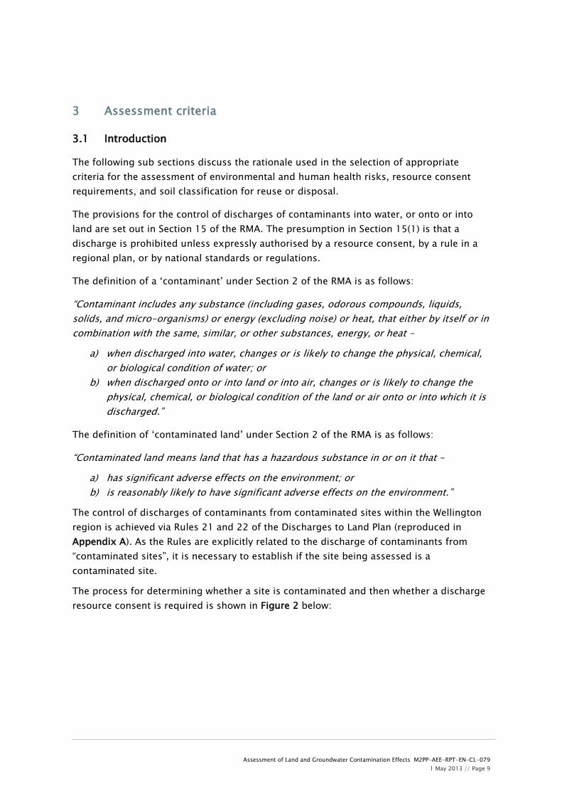
These land parcels have now been investigated, and this report provides the investigation details and assessment of effects from any soil contamination in those areas.
1.1 Purpose and scope
Assessment of Land and Groundwater Contamination Effects, Technical Report 23 was prepared as part of the resource consent application for the Project. This report identified additional areas of potentially contaminated land that required further investigation. This report presents the findings and assessment of the results of the investigation of the additional sites.
The purpose of this contamination assessment is to characterise areas of soil contamination on land parcels identified as potentially contaminated along the route of the Expressway. This will allow the likely environmental effects of the Project to be determined together with any regulatory controls and mitigation measures.
In more detail, this has involved the assessment of:
The presence and distribution of contaminants in soils at selected locations along the route of the Expressway identified as potentially contaminated in the Beca report number M2PP-AEE-RPT-EN-CL-O23 MacKays to Peka Peka, Kāpiti Coast – Contamination Desk Study, June 2011 (Appendix I).
The potential effects of any identified contamination on human health and the environment.
The requirements for resource consent under the Resource Management Act (RMA) 1991, the details of which are set out in the Regional Plan for the Discharges to Land for the Wellington Region, 1999 (Discharges to Land Plan).
Any groundwater and landfill gas within the area of Otaihanga Landfill being developed as the main Project Yard and the potential effects on human health and the environment.
The requirements and options for remediation, management or monitoring of contaminated soils and groundwater, including the potential for re-use of excavated materials along the route of the Expressway and evaluation of off-site disposal options.
1.2 Report structure
The Project has been divided into four Sectors (Sector Diagram, Section 3, Chapter 7, Part D, Volume 2) which broadly define the different rural and urban zones of the Project.
The main body of this report (Sections 5-8) is structured around the four Sectors, with each Sector having its own section. The Sector specific sections are intended to be relatively ‘stand alone’ and each contains the following standard information:

Assessment of Land and Groundwater Contamination Effects M2PP-AEE-RPT-EN-CL-079 1 May 2013 // Page 6
Introduction - location, existing environment, land use, potential contamination.
Investigation activities and methodology - what investigations were carried out and why.
Investigation findings – description of soils, occurrence of fill, detection of soil and/or groundwater contamination, identifying the baseline quality of soils and groundwater and comparison against guideline values.
Discussion – interpretation of results, nature of materials, resource consent requirements, human health impact assessment and soil classification.
Assessment of environmental effects.
Conclusions – summary of key findings and relevance for the construction phase of the Project.
Sections 2 to 4 provide general information and discussion of the Project, the existing environment, the adoption of guideline values and investigation methodology.
All the factual information relevant to each sector (such as investigation logs, laboratory testing summary sheets, field data etc.) is contained within the sector specific appendices to this report.

Assessment of Land and Groundwater Contamination Effects M2PP-AEE-RPT-EN-CL-079 1 May 2013 // Page 7
2 Existing environment
2.1 Geology
The geological sequence beneath the Project area is described in geological map 10 Geology of the Wellington Area 1:250,000 (Geological and Nuclear Sciences, 2000). Full details of the geology in the context of the finalised alignment and the construction envelope can be found in report number M2PP-AEE-RPT-GT-SE-076 Assessment of Ground Settlement Effects. Details of the local geology encountered within each sector are provided in later sections of this report. However, a summary of the general regional geology is given below.
2.1.1 Regional geology
The vertical geological sequence comprises Recent alluvial deposits (sands and gravels) with superimposed areas of swamps and sand dunes. Significant peat deposits are associated with the swamps. The alluvial deposits are underlain by greywacke basement rocks.
The topography of the region is characterised by the mountainous greywacke terrain of the Tararua Ranges in the east which fall steeply to the large coastal plains in the west.
2.2 Hydrology
The Expressway crosses the low-lying coastal plains and dune areas of western Kāpiti district. The characteristics of the area are described below, in so far as they are relevant to hydrology, stormwater and flood risk management.
The majority of this land is modified farm land except where it passes through the urban areas of Raumati, Paraparaumu and Waikanae. The land is characterized by a mix of low peat flats and sand dune formations. The inter-dunal areas are generally low lying and poorly drained. The topography and geology in conjunction with relatively high rainfall are condusive to the formation of wetlands.
The main watercourse systems are shown on drawings M2PP-AEE-DWG-CV-SW-21 and 22. The Waikanae River is the largest watercourse crossed by the Expressway. It is managed by Greater Wellington Regional Council (GWRC). As with the wetlands, the watercourses have been heavily modified by farm or urban development, and there is a flood protection scheme and active management of the Waikanae River.
In addition to the principal watercourses there are many minor streams and drains that are crossed by the Expressway.
The coastal plain is also subject to significant flooding during heavy rainfall events. The rainfall patterns are strongly influenced by prevailing westerly winds, the presence of the coastal hills, and further east the Tararua Ranges.

Assessment of Land and Groundwater Contamination Effects M2PP-AEE-RPT-EN-CL-079 1 May 2013 // Page 8
2.3 Hydrogeology
Detailed discussion of the hydrogeological characteristics of the Project area is beyond the scope of this report (see report M2PP-AEE-RPT-GT-GW-077 Assessment of Groundwater Effects for hydrogeological data). However, certain key aspects of the hydrogeological regime beneath the Project footprint are significant in the context of this assessment, these are discussed below.
2.3.1 Shallow groundwater
Data gathered from parallel hydrogeological investigations by the Alliance on behalf of the NZTA to date have identified a series of sand and gravel aquifers separated by silt, clay and peat aquitards. A shallow unconfined aquifer extends to a depth of approximately 30m. This aquifer supplies water for potable and irrigation use. The shallow aquifer is in hydraulic connection with the Waikanae River and smaller streams in the area and the water table is generally present only a few metres below ground level.
The seasonal variation in groundwater level is in the order of 2m. The general groundwater flow direction is from the Tararua foothills towards the coastline. However there will be localised variations associated with watercourses and wetlands.
2.3.2 Deep groundwater
Beneath the unconfined aquifer lies a series of semi-confined sand and gravel aquifers largely separated by silt. However, the Project is not directly impacting on these deeper aquifers and therefore they are not considered further in this report.
2.3.3 Groundwater abstraction
There are a large number of shallow and deep groundwater abstraction bores along the Kāpiti Coast. Information on shallow boreholes (<10m depth) within a radius of approximately 300m down hydraulic gradient from each of the areas being investigated was reviewed. The main use for the boreholes is for supply of irrigation water. There were no shallow boreholes identified as being used for supply of drinking water.
Assessment of Land and Groundwater Contamination Effects M2PP-AEE-RPT-EN-CL-079 1 May 2013 // Page 9
3 Assessment criteria
3.1 Introduction
The following sub sections discuss the rationale used in the selection of appropriate criteria for the assessment of environmental and human health risks, resource consent requirements, and soil classification for reuse or disposal.
The provisions for the control of discharges of contaminants into water, or onto or into land are set out in Section 15 of the RMA. The presumption in Section 15(1) is that a discharge is prohibited unless expressly authorised by a resource consent, by a rule in a regional plan, or by national standards or regulations.
The definition of a ‘contaminant’ under Section 2 of the RMA is as follows:
“Contaminant includes any substance (including gases, odorous compounds, liquids, solids, and micro-organisms) or energy (excluding noise) or heat, that either by itself or in combination with the same, similar, or other substances, energy, or heat –
a) when discharged into water, changes or is likely to change the physical, chemical, or biological condition of water; or
b) when discharged onto or into land or into air, changes or is likely to change the physical, chemical, or biological condition of the land or air onto or into which it is discharged.”
The definition of ‘contaminated land’ under Section 2 of the RMA is as follows:
“Contaminated land means land that has a hazardous substance in or on it that –
a) has significant adverse effects on the environment; or b) is reasonably likely to have significant adverse effects on the environment.”
The control of discharges of contaminants from contaminated sites within the Wellington region is achieved via Rules 21 and 22 of the Discharges to Land Plan (reproduced in Appendix A). As the Rules are explicitly related to the discharge of contaminants from “contaminated sites”, it is necessary to establish if the site being assessed is a contaminated site.
The process for determining whether a site is contaminated and then whether a discharge resource consent is required is shown in Figure 2 below:

Assessment of Land and Groundwater Contamination Effects M2PP-AEE-RPT-EN-CL-079 1 May 2013 // Page 10
Figure 2: Regional Resource Consent Assessment Flowchart – Discharges of Contaminants
3.2 Assessment of environmental risk
3.2.1 Determination of a contaminated site
Discharge occurring across site boundary
No discharge across site boundary
Q1: Is the site contaminated?
Assess whether discharge is occurring
outside site boundary
Resource consent not
required
No
Assess contamination status of site and return to
Q1
Yes Unknown
Resource consent required
under Rule 22 for any activity.
Soil removed for reuse at another location requires resource consent under Rule 22.
Soil can be reused on site
provided Rule 21 is complied with.

Assessment of Land and Groundwater Contamination Effects M2PP-AEE-RPT-EN-CL-079 1 May 2013 // Page 11
The definition of a contaminated site is given in the Discharges to Land Plan and is as follows: “A site at which a hazardous substance occurs at concentrations above background levels and where assessment indicates it poses or is likely to pose an immediate or long term hazard to human health or the environment.” Site-specific background levels of contaminants should be determined where possible. If these cannot be determined, the background levels detailed in the GWRC report Determination of Common Pollutant Background Soil Concentrations for the Wellington Region, August 2003 should be used. For this assessment, the GWRC background levels have been used, specifically those listed under Main Soil Type 1 (sand) as these best represent the soil type of the Kāpiti Coast. Background levels for contaminants in peat are not listed in the GWRC report.
Given that the Discharges to Land Plan does not specify any threshold concentrations for contaminants (other than background concentrations) above which there is a potential hazard to human health or the environment, the following documents have been adopted to undertake the hazard (risk) assessments:
The hierarchy of guideline values in the Ministry for the Environment (MfE) Contaminated Land Management Guidelines No.2 – Hierarchy and Application in New Zealand of Environmental Guideline Values, 2003.
In Tables 1 and 2 detailed in the following sections, the hierarchy of the reference documents containing guideline values used in establishing the contamination status of a site are in descending order of applicability. The hierarchy works by comparing the concentrations of the identified contaminants of concern against the guideline values defined in the reference documents in each table (in the order tabulated). If the contaminants being assessed are not included in the first reference document then the next document in the list is referred to and so on.
The determination of whether a site is contaminated is based firstly on whether contaminant concentrations are above background levels. If this is the case, an assessment of the risks to human health and the environment from those elevated contaminant concentrations is undertaken. Therefore if a contaminant concentration is below relevant background levels then no further assessment of risk is undertaken. The environmental and human health risk assessments are considered separately in Sections 3.2.2 and 3.2.3.
In some instances the guideline documents provide a range of values for a particular contaminant based on land use and/or soil type. For the areas being assessed along the route, a number of different land uses and soil types have been identified. Given the range of both land use and soil type, it is not proposed to discuss their adoption here. Rather, and where appropriate, the justification for the choice of land use and soil type in selecting guideline values is detailed within each of the sector specific discussions. They

Assessment of Land and Groundwater Contamination Effects M2PP-AEE-RPT-EN-CL-079 1 May 2013 // Page 12
are also indicated on the relevant laboratory testing summary sheets in Appendices C and D.
3.2.2 Determination of a contaminated site based on environmental risk
The hierarchy of the soil guideline values (in descending order of applicability) for the assessment of whether a site is contaminated based on environmental risks from contaminated soils is detailed in Table 1.
Table 1 - Hierarchy for Determination of a Contaminated Site Based on Environmental Risk
Reference Document and Hierarchy
1 Canadian Soil Quality Guidelines for the Protection of Environmental and Human Health, Canadian Council of Ministers of the Environment (CCME), 2012.
2 Guideline on the Investigation Levels for Soil and Groundwater, National Environment Protection Council (NEPC), 1999.
In selecting the most appropriate land use category from these guideline documents, the existing land use at each site has been considered.
3.2.3 Determination of a contaminated site based on human health risk
The hierarchy of the soil guideline values (in descending order of applicability) for the assessment of whether a site is contaminated based on human health risks from contaminated soils is detailed in Table 2.
Table 2 - Hierarchy for Determination of a Contaminated Site Based on Human Health Risk
Reference Document and Hierarchy
1 Guidelines for Assessing and Managing Petroleum Hydrocarbon Contaminated Sites in New Zealand, MfE, 1999.
3 Guideline on the Investigation Levels for Soil and Groundwater, NEPC, 1999
In selecting the most appropriate land use category from these guideline documents, the existing land use at each site has been considered. The guideline documents selected for this assessment are slightly different to those selected in Technical Report 23, in that MfE guideline documents Health and Environmental Guidelines for Selected Timber Treatment Chemicals (1997) and Guidelines for Assessing and Managing Contaminated Gasworks Sites in New Zealand (1997) have not been selected. This change has no effect on the assessment carried out in Technical Report 23 as the criteria from these guidelines were not used.
3.3 Assessment of human health risk
The assessment of human health risks from contaminated soils needs to consider potential effects on workers within the construction footprint and future users of the Expressway.

Assessment of Land and Groundwater Contamination Effects M2PP-AEE-RPT-EN-CL-079 1 May 2013 // Page 13
The hierarchy of the soil guideline values (in descending order of applicability) for the assessment of human health risks from contaminated soils is detailed in Table 3.
Table 3 - Hierarchy for Assessment of Human Health Risk
Reference Document and Hierarchy
1 Resource Management (National Environmental Standard for Assessing and Managing Contaminants in Soil to Protect Human Health) Regulations 2011, MfE
2 Guidelines for Assessing and Managing Petroleum Hydrocarbon Contaminated Sites in New Zealand, MfE, 1999.
3 United States Environmental Protection Agency Regional Screening Levels, April 2012
The assessment of land use consent requirements has been undertaken in accordance with the Resource Management (National Environment Standard for Assessing and Managing Contaminants in Soil to Protect Human Health) Regulations 2011 (NES).
The NES applies to land which currently has, or has historically had, an activity or industry undertaken on it that is included in the Ministry for the Environment Hazardous Activities and Industries List (HAIL), or land which is used as production land. It includes a series of rules specifically related to soil sampling, soil disturbance, fuel systems removal, subdivision, and land use change.
The NES provides a set of chemical specific soil contaminant thresholds (or soil contaminant standards (SCSs)) that define an adequate level of protection for human health for a range of differing land uses in New Zealand. The results of the soil sampling have been assessed against the NES SCSs to give an indication of any health risks to construction workers. The land use selected for this assessment is ‘commercial/industrial outdoor worker: unpaved’.
The human health assessments carried out within this report are not intended to replace any contaminant specific occupational exposure assessment that may be deemed necessary as part of any Health and Safety Plan.
3.4 Assessment of regional resource consent requirements for contaminated sites
The Discharges to Land Plan contaminated land rules focus on whether or not contaminants are discharging across the boundary of a contaminated site. Discharging means contaminants leaving the site by leaching into groundwater, dispersing into air, or migrating through soil. Where contaminants are discharging across the site boundary resource consent is required under Rule 22 for any activity including reuse of materials on site or at another location.
Where contaminants are not discharging across the site boundary, resource consent is not required for the reuse of materials on site provided Rule 21 is complied with. If materials are to be removed from site for reuse at another location (other than disposal to landfill)
Assessment of Land and Groundwater Contamination Effects M2PP-AEE-RPT-EN-CL-079 1 May 2013 // Page 14
then this activity would require resource consent from the Greater Wellington Regional Council under Rule 22. Rules 21 and 22 are reproduced in Appendix A.
In order to determine if contaminants were migrating across a site boundary, where possible soil samples were collected close to the boundary of each assessed site. Where contaminants were identified at concentrations above guideline values at a boundary sampling location then it was conservatively assessed that migration across the site boundary was happening.
3.5 Assessment of soils for reuse or disposal
The assessment (classification) of soils for reuse or disposal is based on:
Observations of soils recovered during ground investigations.
Results of chemical laboratory analyses of soil samples collected during the ground investigations.
These observations and results were obtained from discrete locations based on systematic grid sampling. The actual characteristics of the subsurface materials, particularly in areas of fill, may vary between adjacent sampling locations. In addition, subsurface conditions, including perched groundwater levels and contaminant concentrations can vary over short distances.
3.5.1 Soil classification
The assessment of soils for reuse within the construction footprint or disposal to a licensed facility is based around a standard classification of soils into cleanfill, contaminated fill or highly contaminated fill. A brief definition of these classifications is given below:
Highly Contaminated Fill
Highly contaminated fill in the context of this assessment constitutes:
Soil containing concentrations of contaminants above threshold levels specified in the waste acceptance criteria of a landfill.
Contaminated fill
Contaminated fill comprises:
Soil containing metal contaminants above their Wellington region background concentrations which pose a risk to the environment or to human health.
Soil containing hazardous materials in the form of household and industrial waste, putrescible waste or Asbestos Containing Material (ACM).
Soil that does not contain concentrations of contaminants above threshold levels specified in the waste acceptance criteria of a landfill.

Assessment of Land and Groundwater Contamination Effects M2PP-AEE-RPT-EN-CL-079 1 May 2013 // Page 15
Cleanfill
Cleanfill is defined in the Discharges to Land Plan as:
“…materials such as clay, soil, rock, concrete, or brick, that are free of combustible or putrescible components or hazardous substances or materials likely to create a hazardous leachate by means of biological or chemical breakdown.”
Cleanfill is defined in the MfE document A Guide to the Management of Cleanfills, 2002 as:
“..material that when buried will have no adverse effect on people or the environment; and includes virgin materials such as clay, soil and rock, and other inert materials such as concrete or brick that are free of:
Combustible, putrescible, degradable or leachable components
Hazardous substances
Products or materials derived from hazardous waste treatment, hazardous waste stabilization or hazardous waste disposal practices
Materials that may present a risk to human health
Liquid waste.”
In simple terms, cleanfill includes materials such as uncontaminated soils, cured asphalt, bricks, unreinforced concrete, fibre cement building products (excluding asbestos) and glass. Non cleanfill materials would include soils with contaminants levels above Wellington region background concentrations of metals, asbestos containing materials, asphalt (new), green waste and household refuse.
3.5.2 Reuse or disposal options
Soils classified as cleanfill – These soils can be re-used (subject to obtaining necessary approvals from the district and/or regional council) within the Project footprint or they can be disposed of to a cleanfill facility or operation.
Soils classified as contaminated fill – Depending on the nature of the contamination, these soils can be stabilised and reused within the same property boundary or other location within the Project footprint (subject to obtaining necessary approvals from the district and/or regional council). Alternatively these soils can be disposed of to a licensed landfill site. Each landfill site within the Wellington region is consented by GWRC and has site specific acceptance criteria which dictate what materials can be accepted and will include maximum concentrations for certain contaminants. The acceptance criteria for the closest

Assessment of Land and Groundwater Contamination Effects M2PP-AEE-RPT-EN-CL-079 1 May 2013 // Page 16
landfill site to the Project licensed to accept contaminated fill are detailed in the waste acceptance criteria spreadsheets in Appendices C and D.
Soils classified as highly contaminated fill - These soils must be disposed of to a licensed hazardous waste landfill that can accept fill with high levels of contaminants, or alternatively treated to reduce the levels or mobility of the contaminants to acceptable levels.
The classification of soils based on the results of the Project contamination assessment is discussed within the section for each sector.

Assessment of Land and Groundwater Contamination Effects M2PP-AEE-RPT-EN-CL-079 1 May 2013 // Page 17
4 Methodology
4.1 Investigation activities
As outlined in Section 1.1, the purpose of this contamination assessment is to establish the quality of soil at selected locations within the construction footprint of the Project. The intrusive investigations were informed by the desk study and detailed site inspections (see Appendix I).
The intrusive investigations associated with the contamination assessment comprised the excavation of test pits. In addition, samples of soil were collected for chemical laboratory analysis. Intrusive investigations and sampling were carried out in general accordance with the MfE Contaminated Land Management Guidelines No. 5 - Site Investigation and Analysis of Soils, 2004.
The investigations were carried out between 11 February 2013 and 3 April 2013. Full details of the intrusive investigations including logs, sampling and monitoring details, and laboratory analysis suites and results are provided on a sector specific basis in Appendices C, D and E.
The methods of intrusive investigation and sampling used during the assessment are detailed below in Sections 4.2 to 4.4. All investigation locations are shown on drawing numbers GIS-3320901-87 to 92 and 95 in Appendix B.
4.2 Test pits
Test pits were excavated in Sectors 1 and 2 by Goodmans Contractors Ltd using a Kobelco 12 tonne tracked excavator. Test pits were excavated to a maximum depth of 3m below ground level (bgl). Soils encountered were logged and sampled and test pits were backfilled with the excavated soils and the ground reinstated to its original condition.
All test pit locations were surveyed so that any identified contamination could be delineated and/or remediated as appropriate.
4.3 Hand augers Hand augers were drilled in Sector 2 to a maximum depth of 0.5m bgl using a 50mm diameter auger. Soils encountered were logged and sampled and all hand auger holes were backfilled with the excavated soils. All hand auger locations were surveyed so that any identified contamination could be delineated and/or remediated as appropriate.
4.4 Sampling and monitoring
4.4.1 Soil sampling

Assessment of Land and Groundwater Contamination Effects M2PP-AEE-RPT-EN-CL-079 1 May 2013 // Page 18
The methodology for collecting soil samples was tailored to the method of investigation as follows:
Test Pits – samples were collected from excavated soil placed at the side of the pit or directly from the excavator bucket.
For all soil sampling, nitrile gloves were worn (a clean pair for each new sample) and samples were collected directly by hand or by using a stainless steel trowel or spatula. Samples were placed in plastic or glass jars as provided by the analytical laboratory and chilled.
All samples scheduled for chemical testing were dispatched to the laboratory generally within 24 hours of collection.
4.4.2 Chemical laboratory analyses
All chemical laboratory analyses were performed by R J Hill Laboratories Ltd (Hill Laboratories). A full set of Hill Laboratories results is provided in Appendix G. The analysis suites were tailored to reflect the likely contaminants associated with historical and current land use activities. The full range of analyses at the sites investigated comprised the following:
Soils Heavy metals (HM) – arsenic, cadmium, chromium, copper, lead, nickel and zinc. Semi volatile organic compounds (SVOC) – including polycyclic aromatic hydrocarbons
(PAH). Total petroleum hydrocarbons (TPH). Organophosphorus and organonitrogen (OP/ON) pesticides. Organochlorine pesticides (OCP).
All samples submitted to Hill Laboratories were accompanied by Chain of Custody forms which outline the required handling instructions. The Chain of Custody forms are provided in Appendix H.

Assessment of Land and Groundwater Contamination Effects M2PP-AEE-RPT-EN-CL-079 1 May 2013 // Page 19
5 Sector 1
5.1 Sector description
Sector 1 runs from just south of Poplar Avenue to Raumati Road. This portion of the route will comprise construction of an interchange at Poplar Avenue and stormwater wetlands.
The route passes through the corner of Queen Elizabeth Park and follows approximately the existing Western Link Road (WLR) Designation through Raumati towards the Kāpiti Road intersection.
The generalised geological sequence beneath Sector 1 is expected to comprise sand dunes and peat swamps overlying sandy, gravelly alluvial deposits from the erosion of the mountainous greywacke terrain of the Tararua Ranges in the east.
Several waterways cross Sector 1 including part of the Queen Elizabeth Park Drain and part of Drain 7.
The current land use within this sector is a mixture of residential housing and open bush recreational areas.
5.2 Investigation activities
The objectives of the investigations within this sector were:
To determine if selected areas within the sector were contaminated.
To establish resource consent requirements associated with any identified soil contamination.
To assess any effects of any identified contamination on human health.
To assess any Project environmental effects.
To classify soils for re-use and off site disposal purposes.
The investigations within Sector 1 took place at two locations which were identified in the desk study as having the potential to be contaminated. Those locations were:
16 Leinster Avenue: identified as garden centre with rear of property being used as a contractor’s yard.
150 Raumati Road: area of wetland/bush to the west of Raumati Road where waste materials have been dumped.
A summary of the investigation activities undertaken within these areas is outlined in Table 4. The investigation locations are shown on drawing numbers GIS-3320901-91 and 92 in Appendix B.

Assessment of Land and Groundwater Contamination Effects M2PP-AEE-RPT-EN-CL-079 1 May 2013 // Page 20
Table 4 – Summary of Investigation Activities in Sector 2
Area Rationale Number of samples analysed
Analysis Suite
16 Leinster Avenue Grid spacing - 12 Sampling locations.
(TP101 to TP112)
Analysis suite based on hydrocarbon storage and possible unknown fill materials, and possible herbicide/pesticide use from garden centre.
14 + 1 duplicate
Heavy Metals, TPH, PAH, SVOC
150 Raumati Road Grid spacing - 21 Sampling locations.
(TP101 to TP121)
Analysis suite based on dumping of unknown waste materials.
33 + 2 duplicate
Heavy Metals, TPH, PAH
Notes:
Heavy metals tested comprise arsenic, cadmium, chromium, copper, lead, nickel and zinc
TPH – total petroleum hydrocarbons
SVOC – semi volatile organic compounds PAH – polycyclic aromatic hydrocarbons
Full details of the investigation activities and the methodologies used for these activities are provided in Section 4 and Appendix C. The following subsections outline the investigations carried out and provide a rationale for the sampling and analysis.
5.2.1 16 Leinster Avenue
In order to give statistically representative coverage of the area within the designation at 16 Leinster Avenue a systematic grid system was used based on the MfE document Contaminated Land Management Guidelines No. 5, Site Investigation and Analysis of Soils (2004). The number of sampling locations has been calculated based on the following equations taken from the MfE document:
2GAN
0.59RG
=
=
where:
G = grid size of the sampling pattern, in metres

Assessment of Land and Groundwater Contamination Effects M2PP-AEE-RPT-EN-CL-079 1 May 2013 // Page 21
R = radius of the smallest hot spot that the sampling intends to detect, in metres
0.59 = factor derived from 95% detection probability assuming circular hot spots
N = number of sampling points
A = size of the sampling area, in square metres.
The area of the site was estimated at 4400m2 and the calculation results in the need for a minimum of 12 sampling locations. This gives a grid spacing of approximately 20m with the ability to detect a hotspot of radius approximately 22m with 95% confidence. This was considered appropriate taking into account the possibility of random contamination resulting from the use of the site as a contractor’s yard.
In total, 12 test pits were excavated (see drawing number GIS-3320901-92 in Appendix B for investigation locations). The maximum depth of analysed soil samples was 1.2m below ground level (bgl), this reflected the likely required construction excavation depth in this area. A total of 17 soil samples were scheduled for chemical laboratory analysis and the analysis suite is summarised in Table 4 and detailed in Appendix C.
5.2.2 150 Raumati Road
In order to give statistically representative coverage of the area identified as containing dumped waste materials at 150 Raumati Road a systematic grid system was used based on the MfE document Contaminated Land Management Guidelines No. 5, Site Investigation and Analysis of Soils (2004).
The area of the site was estimated at 9000m2 and the calculation results in the need for a minimum of 20 sampling locations. This gives a grid spacing of 21m with the ability to detect a hotspot of radius approximately 25m with 95% confidence. This was considered appropriate taking into account the presence of visible waste materials at the surface.
In total, 21 test pits were excavated (see drawing number GIS-3320901-91 in Appendix B for investigation locations). The maximum depth of analysed soil samples was 2.1m below ground level (bgl), this reflected the general thickness of fill and the potential vertical extent of contamination. A total of 32 soil samples were scheduled for chemical laboratory analysis and the analysis suite is summarised in Table 4 and detailed in Appendix C.
5.3 Soil investigation findings
5.3.1 16 Leinster Avenue
Review of the test pit logs has confirmed the geology beneath the site to comprise fill or reworked natural materials (sandy silts) overlying sand and peat deposits. The fill was predominantly a silty sand with gravel and inclusions of waste materials comprising

Assessment of Land and Groundwater Contamination Effects M2PP-AEE-RPT-EN-CL-079 1 May 2013 // Page 22
plastic, brick, concrete, geotextile, asphalt, timber. Waste materials were identified at locations TP103LG, TP106LG, TP109LG, TP110LG and TP112LG.
Groundwater, as a rapid inflow, was encountered at location TP102LG at a depth of 1.6m bgl.
The following land uses or receptors were considered most appropriate when selecting guideline values:
Contaminated Site Assessment - commercial land use.
Human Health Risks - commercial/industrial outdoor worker.
The chemical analysis results for soils revealed that two samples contained contaminants that exceeded background concentrations and their environmental guideline values and these are detailed in Table 5 below (see Appendix C for full results) and shown on drawing number GIS-3320901-96 in Appendix F.
Table 5 – Contaminants Exceeding Guideline Values at 16 Leinster Avenue
Location Contaminant Depth (m) Concentration (mg/kg)
Background Concentration
(mg/kg)
Environ-mental
Criterion (mg/kg)
TP110LG Benzo[a]pyrene 1.2 1.1 0.002-0.005 0.7 TP112LG Benzo[a]pyrene 0.1 0.73 0.002-0.005 0.7
Results exceeding environmental risk criteria are shaded grey.
5.3.2 150 Raumati Road
Review of the test pit logs has confirmed the geology beneath the site to comprise fill overlying peat deposits. The fill was predominantly a sandy silt with gravel and inclusions of waste materials comprising timber, asphalt, brick, glass, ceramic, concrete, plastic, metal items and household refuse. Waste materials were identified at almost all locations. Olfactory evidence for hydrocarbon contamination was noted at locations TP105LG, TP106LG and TP111LG.
Groundwater, as a slow inflow, was encountered at over half the locations at depths of between 1.7m and 2.7m bgl.
The following land uses or receptors were considered most appropriate when selecting guideline values:
Contaminated Site Assessment - commercial land use.
Human Health Risks - commercial/industrial outdoor worker (unpaved).
The chemical analysis results for soils revealed that several samples contained contaminants that exceeded background concentrations and their environmental guideline

Assessment of Land and Groundwater Contamination Effects M2PP-AEE-RPT-EN-CL-079 1 May 2013 // Page 23
values and these are detailed in Table 6 below (see Appendix C for full results) and shown on drawing number GIS-3320901-97 in Appendix F.
Table 6 – Contaminants Exceeding Guideline Values at 150 Raumati Road
Location Contaminant Depth (m)
Concentration (mg/kg)
Background Concentration
(mg/kg)
Environ-mental
Criterion (mg/kg)
Human Health
Criterion (mg/kg)
TP105RB Lead 1.9 960 4.5-180 260 3300 Zinc 1.9 730 28-79 360 31000 TP106RB Lead 0.3 350 4.5-180 260 3300 TP109RB Zinc 1.6 920 28-79 360 31000 TP113RB Zinc 2.0 590 28-79 360 31000 TP121RB Benzo[a]pyrene 0.2 0.8 0.002-0.005 0.7 -
Results exceeding environmental risk criteria are shaded grey.
5.4 Discussion
5.4.1 Nature of materials
The investigations in Sector 1 have shown the geology to comprise fill or reworked natural materials (sandy silts) overlying sand dunes and peat deposits. The observed fill was predominantly a silty sand with gravel and inclusions of waste materials comprising timber, asphalt, brick, glass, geotextile, ceramic, concrete, plastic, metal items and household refuse. Waste materials were identified at almost all locations at 150 Raumati Road and at five locations at 16 Leinster Avenue. Olfactory (but not analytical) evidence for hydrocarbon contamination was identified at three locations 150 Raumati Road.
5.4.2 Assessment of human health risks
The results of soil analyses at 16 Leinster Avenue and 150 Raumati Road have revealed that contaminant concentrations do not exceed human health criteria. Soils at these sites pose a low risk to human health.
5.4.3 Assessment of environmental risks
The environmental criterion for benzo[a]pyrene (BaP) was slightly exceeded at 16 Leinster Avenue at two locations. The environmental criterion for lead, zinc or BaP was exceeded at 150 Raumati Road at a few locations. These locations are presented on drawing number GIS-3320901-96 and 97 in Appendix F. The environmental risks from BaP and heavy metals would result from discharge to groundwater and dispersal of contaminated soils during construction.
5.4.4 Assessment of discharge resource consent requirements
The definition of a contaminated site as given in the Discharges to Land Plan is as follows:

Assessment of Land and Groundwater Contamination Effects M2PP-AEE-RPT-EN-CL-079 1 May 2013 // Page 24
“A site at which a hazardous substance occurs at concentrations above background levels and where assessment indicates it poses or is likely to pose an immediate or long term hazard to human health or the environment.”
The results of soil analyses within Sector 1 show that there are contaminants present at concentrations which exceed background levels and environmental risk criteria at isolated locations on each site. Therefore the sites at 16 Leinster Avenue and 150 Raumati Road are conservatively classified as contaminated sites.
16 Leinster Avenue:
The results of chemical analysis of soil samples from the boundary of the site show that contaminants (PAH) are present in concentrations exceeding guideline values. Excavation of soils for disposal to a licensed landfill would not require a discharge consent under Rule 22 of the Discharges to Land Plan. If however soils at locations TP110 and TP112 are to be reused on site or removed for reuse at another location, this activity may require a discharge resource consent under Rule 22 of the Discharges to Land Plan.
150 Raumati Road:
As the area under investigation was in the centre of a large land parcel, elevated levels of contaminants (heavy metals and PAH) are unlikely to be discharging across the site boundary. Excavation of soils for disposal to a licensed landfill would not require a discharge consent under Rule 22 of the Discharges to Land Plan. Reuse of soils on site may not require a discharge resource consent as long as the requirements of Rule 21 can be complied with. If however soils are to be removed for reuse at another location, this activity may require a discharge resource consent under Rule 22 of the Discharges to Land Plan.
5.4.5 Assessment of land use resource consent requirements
16 Leinster Avenue:
Part of this land parcel has historically been used for parking trucks, storing firewood and storing and/or dumping of waste materials. There was no evidence of any refuelling activities having occurred. There was no evidence of the widespread use or bulk storage of pesticides or herbicides associated with the garden centre. This site has been conservatively classified as a HAIL site due to the following activity:
G5 – waste disposal to land.
The volume of soil disturbance and disposal is unlikely to be able to comply with the Permitted Activity volumes of Regulation 8(3) of the NES. The results of the investigation showed that contaminant concentrations did not exceed the relevant human health criteria under Regulation 7 of the NES. The soil disturbance activities at this site would therefore require a Controlled Activity consent under Regulation 9 of the NES.
150 Raumati Road:

Assessment of Land and Groundwater Contamination Effects M2PP-AEE-RPT-EN-CL-079 1 May 2013 // Page 25
Part of this land parcel has historically been used as a landfill for many years and waste materials were uncovered during the investigation. This site has been classified as a HAIL site due to the following activity:
G5 – waste disposal to land.
Should this site require excavation, the volume of soil disturbance and disposal is unlikely to be able to comply with the Permitted Activity volumes of Regulation 8(3) of the NES. The results of the investigation showed that contaminant concentrations did not exceed the relevant human health criteria under Regulation 7 of the NES. The soil disturbance activities at this site would therefore require a Controlled Activity consent under Regulation 9 of the NES.
5.4.6 Proposed mitigation of effects
All excavations at both sites should be carried out and managed in accordance with the Contaminated Soils and Groundwater Management Plan (CSGMP), the Contaminated Soils Management Plan (Human Health) and the Contractor Health and Safety Plan (CHSP). Adherence to such plans will control the off-site migration of any, as yet, unidentified contaminants and minimise the exposure of construction workers to potentially contaminated soils. The CSGMP and CSMP(HH) are sub-plans to the CEMP.
5.4.7 Soil classification
One of the aims of the construction methodology for the Project is to minimise the volume of soils that are disposed to landfill therefore the soils at 16 Leinster Avenue and 150 Raumati Road have not been classified for disposal.
Should soils containing elevated levels of contaminants at either site be required for reuse at the same or another site, containment of the contaminants (for example using cement stabilisation) should be considered prior to reuse. Alternatively these soils can be disposed of to landfill.
Non-natural materials were encountered at all locations at 150 Raumati Road and five locations at 16 Leinster Avenue. The presence of materials such as metal, wood, peat and other biodegradables precludes acceptance of the soils as cleanfill material at a landfill.
5.5 Summary of effects and proposed mitigation
Based on the findings of the investigation for this sector, the potential effects on the environment are detailed in Table 7 below, along with appropriate mitigation measures:
Table 7 - Sector 1: Assessment of Environmental Effects
Area Effect Mitigation
16 Leinster Avenue and
Exposure of construction workers to potentially
Containment of contaminants using cement stabilisation or excavation and

Assessment of Land and Groundwater Contamination Effects M2PP-AEE-RPT-EN-CL-079 1 May 2013 // Page 26
150 Raumati Road
contaminated soils (dermal contact, accidental ingestion, inhalation of dust)
Discharge of soil contaminants to air, land and surface water/groundwater during construction.
disposal to landfill. Compliance with land use and
discharge Resource Consent conditions.
Adherence to the CSGMP to prevent discharge of contaminants to land and discharge of contaminants to water.
Adherence to the CSMP(HH) to minimise exposure of construction workers to potentially contaminated soils.
Use of dust suppression controls as per CAQMP.
Use of erosion and sediment controls as per ESCP.
More detail on the mitigation measures to address the potential effects from the discharge of soil contaminants to air, land and water are provided within the CSGMP and CSMP(HH). The key measures are summarised in Section 9 of this report.
5.6 Conclusions
The investigations in Sector 1 have shown that soils comprise fill or reworked natural materials (organic sandy silts) overlying sand dunes and peat deposits. The observed fill was predominantly a silty sand with gravel, and inclusions of waste materials at almost all locations at 150 Raumati Road and at five locations at 16 Leinster Avenue.
The results of soil analyses within Sector 1 show that there are isolated locations of contaminants present at concentrations which exceed background levels and environmental criteria (lead, zinc and PAH). Therefore the sites at 16 Leinster Avenue and 150 Raumati Road are conservatively classified as contaminated sites. The concentrations of contaminants did not exceed human health criteria under Regulation 7 of the NES.
The results of soil analyses at 16 Leinster Avenue and 150 Raumati Road showed that concentrations of contaminants do not pose a risk to human health. Soil disturbance activities are unlikely to be able to comply with the Permitted Activity criteria of Regulation 8(3). Soil disturbance activities at these sites may require a Controlled Activity consent under Regulation 9 of the NES.
Activities at 16 Leinster Avenue involving the reuse of soils on site or the removal of soils for reuse at another location may require a discharge resource consent under Rule 22 of the Discharges to Land Plan. Soils at 150 Raumati Road may be reused on site, but may require a discharge resource consent under Rule 22 of the Discharges to Land Plan if soils are reused at another location.
Assessment of Land and Groundwater Contamination Effects M2PP-AEE-RPT-EN-CL-079 1 May 2013 // Page 27
Potential environmental effects relate to the discharge of soil contaminants to groundwater, surface water and land during construction. Potential human health effects relate to the exposure of construction workers to contaminated soils and the inhalation of airborne soil contaminants by the public.
The effects can be mitigated by the excavation and disposal off-site of contaminated soils, containment of contaminants on site, compliance with discharge and human health resource consent conditions and adherence to management methods and procedures to protect human health and the environment detailed in the CSGMP, CSMP(HH), CAQMP and the ESCP.

Assessment of Land and Groundwater Contamination Effects M2PP-AEE-RPT-EN-CL-079 1 May 2013 // Page 28
6 Sector 2
6.1 Sector description
This sector runs along the existing WLR Designation through the area of Paraparaumu from Raumati Road to 300m north of Mazengarb Road. Underbridges will be constructed over local roads at Raumati Road and Mazengarb Road, with an underbridge spanning the Wharemauku Stream. A new intersection will be constructed at Kāpiti Road.
The portion of the route from Raumati Road to Kāpiti Road passes through a semi-rural area. At Kāpiti Road there is significant residential development to the east of the alignment and commercial industrial businesses to the west. From Kāpiti Road to Fytfield Place residential properties border the route on the east with interspersed residential and rural properties to the west.
The generalised geological sequence beneath Sector 2 is expected to comprise sand dunes and peat swamps overlying sandy, gravelly alluvial deposits from the erosion of the mountainous greywacke terrain of the Tararua Ranges in the east. Fill is expected to overlie natural deposits at some locations.
Several waterways cross Sector 2 including Drain 7, the Wharemauku Stream and Drain 5.
The current land use within this sector is a mix of rural and residential. The alignment follows the existing WLR Designation for the whole of this section of the route through the township of Paraparaumu.
6.2 Investigation activities and methodology
The objectives of the investigations within this sector were:
To determine if selected areas within the sector were contaminated.
To establish resource consent requirements associated with any identified soil contamination.
To assess any effects of any identified contamination on human health.
To assess any Project environmental effects.
To classify soils for re-use and off site disposal purposes.
The investigations within Sector 2 took place at locations identified in the desk study as having the potential to be contaminated. Those locations were:
55 Rata Road: previously investigated due to the storage of fuels identified on the GWRC selected land use register.
61 Rata Road: recent dumping of waste items including vehicles and whiteware. 58 Kiwi Road: historical use of site for market gardening activities.
Assessment of Land and Groundwater Contamination Effects M2PP-AEE-RPT-EN-CL-079 1 May 2013 // Page 29
109 Kāpiti Road: currently used as a firewood storage area and ground level has been raised with unknown fill materials.
The site at 61 Rata Road was not identified in the desk study as being potentially contaminated. The site has been recently used for storing waste or scrap materials, including vehicles and whiteware. This was identified during a site inspection by the Project team, and was consequently added to the list of sites to be investigated.
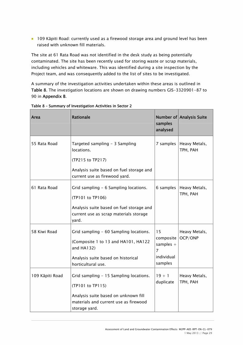
A summary of the investigation activities undertaken within these areas is outlined in Table 8. The investigation locations are shown on drawing numbers GIS-3320901-87 to 90 in Appendix B.
Table 8 – Summary of Investigation Activities in Sector 2
Area Rationale Number of samples analysed
Analysis Suite
55 Rata Road Targeted sampling - 3 Sampling locations.
(TP215 to TP217)
Analysis suite based on fuel storage and current use as firewood yard.
7 samples Heavy Metals, TPH, PAH
61 Rata Road Grid sampling - 6 Sampling locations.
(TP101 to TP106)
Analysis suite based on fuel storage and current use as scrap materials storage yard.
6 samples Heavy Metals, TPH, PAH
58 Kiwi Road Grid sampling - 60 Sampling locations.
(Composite 1 to 13 and HA101, HA122 and HA132)
Analysis suite based on historical horticultural use.
15 composite samples + 7 individual samples
Heavy Metals, OCP/ONP
109 Kāpiti Road Grid sampling - 15 Sampling locations.
(TP101 to TP115)
Analysis suite based on unknown fill materials and current use as firewood storage yard.
19 + 1 duplicate
Heavy Metals, TPH, PAH

Assessment of Land and Groundwater Contamination Effects M2PP-AEE-RPT-EN-CL-079 1 May 2013 // Page 30
Notes:
Heavy metals tested comprise arsenic, cadmium, chromium, copper, lead, nickel and zinc
TPH – total petroleum hydrocarbons
PAH – polycyclic aromatic hydrocarbons OCP – organochlorine pesticides ONP – organonitro & organophosphorus
pesticides
Full details of the investigation activities and the methodologies used for these activities are provided in Section 4 and Appendix D. The following subsections outline the investigations carried out and provide a rationale for the sampling and analysis.
6.2.1 55 Rata Road
During the initial investigation of this site, three sampling locations were unable to be accessed (TP215 to TP217). These locations were accessed during this second investigation.
In total, three test pits were excavated (see drawing number GIS-3320901-87 in Appendix B for investigation locations). The maximum depth of analysed soil samples was 1.9m below ground level (bgl), this reflected the general thickness of fill and the potential vertical extent of contamination. A total of 7 soil samples were scheduled for chemical laboratory analysis and the analysis suite is summarised in Table 8 and detailed in Appendix D.
6.2.2 61 Rata Road
In order to give statistically representative coverage of the area where waste items had been dumped at 61 Rata Road a systematic grid system was used based on the MfE document Contaminated Land Management Guidelines No. 5, Site Investigation and Analysis of Soils (2004).
The area of the site was estimated at 1000m2 and this calculation results in the need for a minimum of 6 sampling locations. This gave a grid spacing of 13m with the ability to detect a hotspot of radius approximately 15m with 95% confidence. This was considered appropriate taking into account the presence of visible waste items on the surface.
In total, 6 test pits were excavated (see drawing number GIS-3320901-89 in Appendix B for investigation locations). The maximum depth of analysed soil samples was 0.5m below ground level (bgl), this reflected the likely vertical extent of contamination. A total of 6 soil samples were scheduled for chemical laboratory analysis and the analysis suite is summarised in Table 8 and detailed in Appendix D.
This site is considered to only be partially investigated. Scrap waste materials (vehicles and whiteware) were unable to be moved during the investigation in order to sample beneath them. Access was also prevented to old stockpiles of materials at the site.
6.2.3 58 Kiwi Road

Assessment of Land and Groundwater Contamination Effects M2PP-AEE-RPT-EN-CL-079 1 May 2013 // Page 31
In order to give statistically representative coverage of the area at 58 Kiwi Road a systematic grid system was used based on the MfE document Contaminated Land Management Guidelines No. 5, Site Investigation and Analysis of Soils (2004).
The area of the site was estimated at 58,000m2 and this calculation results in the need for a minimum of 60 sampling locations. This gave a grid spacing of approximately 30m with the ability to detect a hotspot of radius approximately 35m with 95% confidence. This was considered appropriate taking into account the likely even distribution of potential contaminants associated with horticultural activities.
In total, 60 hand augers were drilled (see drawing number GIS-3320901-88 in Appendix B for investigation locations). The maximum depth of analysed soil samples was 0.15m below ground level (bgl), this reflected the likely vertical extent of contamination. Given the likely even distribution of potential pesticides/herbicides across the site, composite sampling was considered appropriate to assess the area. A total of 15 composite soil samples and 7 individual soil samples were scheduled for chemical laboratory analysis and the analysis suite is summarised in Table 8 and detailed in Appendix D.
6.2.4 109 Kāpiti Road
In order to give statistically representative coverage of the raised fill area at 109 Kāpiti Road a systematic grid system was used based on the MfE document Contaminated Land Management Guidelines No. 5, Site Investigation and Analysis of Soils (2004).
The area of the site was estimated at 6000m2 and this calculation results in the need for a minimum of 15 sampling locations. This gave a grid spacing of approximately 20m with the ability to detect a hotspot of radius approximately 24m with 95% confidence. This was considered appropriate taking into account the apparent large volume of fill imported to level the site for use.
In total, 15 test pits were excavated (see drawing number GIS-3320901-90 in Appendix B for investigation locations). The maximum depth of analysed soil samples was 1.2m below ground level (bgl), this reflected the general thickness of fill and the potential vertical extent of contamination. A total of 19 soil samples were scheduled for chemical laboratory analysis and the analysis suite is summarised in Table 8 and detailed in Appendix D.
6.3 Soil investigation findings
6.3.1 55 Rata Road
Review of the test pit logs has confirmed the geology beneath the site to comprise fill or reworked natural materials (sandy silts) overlying sand and peat deposits. The fill was predominantly a silty sand with gravel and inclusions of waste materials comprising metal, concrete, plastic, timber, iron sheeting, large metal items (car engine, switchbox). Waste materials were identified at locations TP215 and TP217.
Groundwater, as a rapid inflow, was encountered at location TP216 at a depth of 2.4m bgl.

Assessment of Land and Groundwater Contamination Effects M2PP-AEE-RPT-EN-CL-079 1 May 2013 // Page 32
The following land uses or receptors were considered most appropriate when selecting guideline values:
Contaminated Site Assessment - commercial land use.
Human Health Risks - commercial/industrial outdoor worker (unpaved).
The chemical analysis results for soils revealed that one sample contained contaminants that exceeded background concentrations and their environmental and human health guideline values and these are detailed in Table 9 below (see Appendix D for full results) and shown on drawing number GIS-3320901-99 in Appendix F.
Table 9 – Contaminants Exceeding Guideline Values at 55 Rata Road
Location Contaminant Depth (m) Concentration (mg/kg)
Background Concentration
(mg/kg)
Environ-mental
Criterion (mg/kg)
Human Health
Criterion (mg/kg)
TP117 Arsenic 0.5 119 <2-7 12 70 Chromium 0.5 440 7-12 86 NL Copper 0.5 146 4-10 91 NL
Results exceeding environmental criteria are shaded grey. Results exceeding human health criteria are in bold. NL – contaminants not limiting. It may be worth noting that this combination of contaminants is indicative of a CCA treated timber source.
6.3.2 61 Rata Road
Review of the test pit logs has confirmed the geology beneath the site to comprise fill overlying sand dunes and peat deposits. The fill was predominantly a silty gravel. Waste materials were not encountered.
Groundwater was not encountered.
The following land uses or receptors were considered most appropriate when selecting guideline values:
Contaminated Site Assessment - commercial land use.
Human Health Risks - commercial/industrial outdoor worker (unpaved).
The chemical analysis results for soils revealed that no samples contained contaminants that exceeded environmental or human health guideline values.
6.3.3 58 Kiwi Road
Review of the test pit logs has confirmed the geology beneath the site to reworked natural materials (organic sandy silts). Waste materials were not encountered.

Assessment of Land and Groundwater Contamination Effects M2PP-AEE-RPT-EN-CL-079 1 May 2013 // Page 33
Groundwater was not encountered.
The following land uses or receptors were considered most appropriate when selecting guideline values:
Contaminated Site Assessment - commercial land use.
Human Health Risks - commercial/industrial outdoor worker (unpaved).
As most of the samples from this site were analysed as composite samples, the guideline values have been adjusted to take this into account. The guideline values have been divided by the number of sub-samples in each composite – four in each case.
The chemical analysis results for soils revealed that all samples contained contaminants that exceeded background concentrations and their (adjusted) environmental guideline values and these are detailed in Table 10 below (see Appendix D for full results) and shown on drawing number GIS-3320901-100 in Appendix F. Table 10 – Contaminants Exceeding Guideline Values at 58 Kiwi Road
Location Contaminant Depth (m)
Concentration (mg/kg)
Background Concentration
(mg/kg)
Environ-mental
Criterion (mg/kg)
Human Health
Criterion (mg/kg)
All composite samples (except 10)
Arsenic 0.15 5-14 <2-7 3 17.5
Composite 10 Arsenic 0.15 26 <2-7 3 17.5 All composite samples (except 5, 7 and 9)
Copper 0.15 42-88 4-10 22.75 NL
Composite 1 Zinc 0.15 93 28-79 90 7750 HA132 Copper 0.15 186 4-10 91 NL Results exceeding environmental risk criteria are shaded grey. Results exceeding human health risk criteria are in bold. NL – contaminants not limiting. Due to the exceedance of human health guideline value for arsenic in Composite sample 10, the sub-samples were retested for arsenic and compared to the guideline value. The concentration of arsenic in the sub-samples did not exceed human health guideline values. The results of the retesting are included in Appendix D.
6.3.4 109 Kāpiti Road
Review of the test pit logs has confirmed the geology beneath the site to comprise fill overlying peat deposits. The fill was predominantly a clayey silty sand with gravel and inclusions of waste materials comprising concrete, asphalt millings, timber and plastic. Waste materials were identified at locations TP101, TP102, TP110, TP111 and TP113.

Assessment of Land and Groundwater Contamination Effects M2PP-AEE-RPT-EN-CL-079 1 May 2013 // Page 34
Groundwater, as either a slow seep or moderate to rapid inflow, was encountered at six locations (TP101, TP107, TP110, TP111, TP113 and TP115) at depths between 1.2 and 3m bgl.
The following land uses or receptors were considered most appropriate when selecting guideline values:
Contaminated Site Assessment - commercial land use.
Human Health Risks - commercial/industrial outdoor worker (unpaved).
The chemical analysis results for soils revealed that one sample contained contaminants that exceeded background concentrations and environmental guideline value and this is detailed in Table 11 below (see Appendix D for full results) and shown on drawing number GIS-3320901-98 in Appendix F.
Table 11 – Contaminants Exceeding Guideline Values at 109 Kāpiti Road
Location Contaminant Depth (m)
Concentration (mg/kg)
Background Concentration
(mg/kg)
Environ-mental
Criterion (mg/kg)
Human Health
Criterion (mg/kg)
TP109 Benzo[a]pyrene 0.2 1.02 0.002-0.005 0.7 - Results exceeding environmental risk criteria are shaded grey.
6.4 Discussion
6.4.1 Nature of materials
The investigations in Sector 2 have shown the geology to comprise fill overlying sand dunes and peat deposits. The observed fill was predominantly a silty sand with gravel and inclusions of waste materials comprising concrete, asphalt millings, metal items, timber and plastic. Waste materials were identified at two locations at 55 Rata Road and five locations at 109 Kāpiti Road.
6.4.2 Assessment of human health risks
The results of soil analyses at 58 Kiwi Road showed that the arsenic concentration in Composite sample 10 exceeded the human health criterion; however retesting of each sub-sample showed that the arsenic concentration did not exceed the human health criterion.
The results of soil analyses at 55 Rata Road have revealed that contaminant concentrations at location TP217 exceeded human health criteria. Soils at these locations pose risk to human health. The results are shown on drawing number GIS-3320901-99 in Appendix F. The risks to those working on the site from contaminated soils are from dermal contact,

Assessment of Land and Groundwater Contamination Effects M2PP-AEE-RPT-EN-CL-079 1 May 2013 // Page 35
accidental ingestion and inhalation of contaminated dust. The risks to members of the public living adjacent to or walking past the site are from inhalation of contaminated dust.
The results of soil analyses at 61 Rata Road and 109 Kāpiti Road have revealed that contaminant concentrations did not exceed human health criteria. Soils at these sites pose a low risk to human health.
6.4.3 Assessment of environmental risks
The environmental criteria for arsenic, chromium and copper were exceeded at 55 Rata Road at one location. The environmental criteria for arsenic and copper were exceeded at 58 Kiwi Road at almost all locations, with one location exceeding the environmental criterion for zinc. The environmental criterion for benzo[a]pyrene (BaP) was exceeded at 109 Kāpiti Road at one location.
These locations are presented on drawing numbers GIS-3320901-98 to 100 in Appendix F. The environmental risks from BaP and heavy metals would result from discharge to groundwater and dispersal of contaminated soils during construction.
6.4.4 Assessment of discharge resource consent requirements
The definition of a contaminated site as given in the Discharges to Land Plan is as follows: “A site at which a hazardous substance occurs at concentrations above background levels and where assessment indicates it poses or is likely to pose an immediate or long term hazard to human health or the environment.”
The results of soil analyses within Sector 2 show that there are contaminants present at concentrations which exceed background levels and environmental risk criteria at each site except 61 Rata Road. Therefore the sites at 55 Rata Road, 58 Kiwi Road and 109 Kāpiti Road are conservatively classified as contaminated sites. The site at 61 Rata Road is also conservatively considered a contaminated site for the reasons given below.
55 Rata Road:
The results of chemical analysis of soil samples from the boundary of the site show that contaminants (arsenic) are present in concentrations exceeding guideline values. Excavation of soils for disposal to a licensed landfill would not require a discharge consent under Rule 22 of the Discharges to Land Plan. If however soils at locations TP217 are to be reused on site or removed for reuse at another location, this activity may require a discharge resource consent under Rule 22 of the Discharges to Land Plan.
61 Rata Road:
The results of chemical analysis of soil samples showed that contaminants concentrations did not exceed guideline values. However, the investigation carried out at this site was only considered a partial investigation due to the inability to move scrap items and materials present, or access potential historical stockpiles. This site is therefore conservatively considered to be a contaminated site. Excavation of soils for disposal to a licensed landfill would not require a discharge consent under Rule 22 of the Discharges to

Assessment of Land and Groundwater Contamination Effects M2PP-AEE-RPT-EN-CL-079 1 May 2013 // Page 36
Land Plan. If however soils are to be reused on site or removed for reuse at another location, this activity may require a discharge resource consent under Rule 22 of the Discharges to Land Plan.
58 Kiwi Road:
The results of chemical analysis of soil samples from the boundary of the site showed that contaminants (arsenic, copper and zinc) are present in concentrations exceeding guideline values. Excavation of soils for disposal to a licensed landfill would not require a discharge consent under Rule 22 of the Discharges to Land Plan. If however soils are to be reused on site or removed for reuse at another location, this activity may require a discharge resource consent under Rule 22 of the Discharges to Land Plan.
109 Kāpiti Road:
The results of chemical analysis of soil samples from the boundary of the site showed that contaminants (PAH) are present in concentrations exceeding guideline values. Excavation of soils for disposal to a licensed landfill would not require a discharge consent under Rule 22 of the Discharges to Land Plan. If however soils are to be reused on site or removed for reuse at another location, this activity may require a discharge resource consent under Rule 22 of the Discharges to Land Plan.
6.4.5 Assessment of land use resource consent requirements
55 Rata Road:
This land parcel is classified by GWRC as a HAIL site for the following activity:
A17 – storage of fuel.
Investigations at this site have shown that waste materials have been buried across the site. This activity is identified on the HAIL list as follows:
G5 – waste disposal to land.
The volume of soil disturbance and disposal is unlikely to be able to comply with the Permitted Activity volumes of Regulation 8(3) of the NES. The results of the investigation showed that contaminant concentrations exceed the relevant human health criteria under Regulation 7 of the NES. The soil disturbance activities at this site would therefore require a Restricted Discretionary Activity consent under Regulation 10 of the NES.
61 Rata Road:
Part of this land parcel is being used for storing scrap and waste materials. This site has been conservatively classified as a HAIL site due to the following activity:
G5 – waste disposal to land.
The volume of soil disturbance and disposal is unlikely to be able to comply with the Permitted Activity volumes of Regulation 8(3) of the NES. The results of the investigation

Assessment of Land and Groundwater Contamination Effects M2PP-AEE-RPT-EN-CL-079 1 May 2013 // Page 37
showed that contaminant concentrations did not exceed the relevant human health criteria under Regulation 7 of the NES. The soil disturbance activities at this site would therefore require a Controlled Activity consent under Regulation 9 of the NES.
58 Kiwi Road:
This land parcel has been used historically for horticulture. Investigations showed that contaminants associated with this activity are present in the soil. This site has been classified as a HAIL site due to the following activity:
A10 – persistent pesticide use.
The volume of soil disturbance and disposal is unlikely to be able to comply with the Permitted Activity volumes of Regulation 8(3) of the NES. The results of the investigation showed that contaminant concentrations exceeded the relevant human health criteria under Regulation 7 of the NES. The soil disturbance activities at this site would therefore require a Restricted Discretionary Activity consent under Regulation 10 of the NES.
109 Kāpiti Road:
The area used for the storage of firewood has been raised from its original height through the placement of fill. Results of soil samples collected within the fill showed that levels of contaminants are similar to background levels. No HAIL activities have been identified as taking place in this area. The site is therefore not subject to control under the NES.
6.4.6 Proposed mitigation of effects
55 Rata Road:
The soils at location TP217 (55 Rata Road) should be excavated and disposed of to landfill to avoid on-going potential health risks. The excavation of the contaminated soils should be completed prior to any construction works commencing at the site. The contaminated soils should be disposed of to a landfill licensed to accept the contaminant levels in the soils. Alternatively the soils may need to be treated to reduce the mobility or toxicity of the contaminants. Soil sampling of the contaminated area should be undertaken post-excavation to ensure the contaminated soils have been removed.
Land disturbance activities at this site will require special management procedures to protect workers and the general public from exposure to soil contaminants. All excavations should be carried out and managed in accordance with the CSGMP, CSMP(HH) and CHSP. Adherence to such plans will control the off-site migration of any, as yet, unidentified contaminants and minimise the exposure of construction workers to contaminated soils.
61 Rata Road,109 Kāpiti Road and 58 Kiwi Road:
All excavations at these sites should be carried out and managed in accordance with the CSGMP, CSMP(HH) and CHSP. Adherence to such plans will control the off-site migration of

Assessment of Land and Groundwater Contamination Effects M2PP-AEE-RPT-EN-CL-079 1 May 2013 // Page 38
any, as yet, unidentified contaminants and minimise the exposure of construction workers to potentially contaminated soils. The CSGMP and CSMP(HH) are sub-plans to the CEMP.
6.4.7 Soil classification
One of the aims of the construction methodology for the Project is to minimise the volume of soils that are disposed to landfill therefore the soils at 55 Rata Road, 61 Rata Road, 58 Kiwi Road and 109 Kāpiti Road have not been classified for disposal.
The exception is where soils have been identified as containing concentrations of contaminants that pose a risk to human health. Soils at TP217 (and TP209 from the investigation carried out by Beca in 2011) at 55 Rata Road are classified as highly contaminated and will require excavation and disposal to landfill. These soils should not be reused.
Should other soils containing elevated levels of contaminants (but not posing a risk to human health) at any site be required for reuse at the same or another site, containment of the contaminants (for example using cement stabilisation) should be considered prior to reuse. Alternatively these soils can be disposed of to landfill.
Buried non-natural materials were encountered at two locations at 55 Rata Road and five locations at 109 Kāpiti Road. The presence of materials such as metal, wood, peat and other biodegradables precludes acceptance of the soils as cleanfill material at a landfill.
6.5 Summary of effects and proposed mitigation
Based on the findings of the investigation for this sector, the potential effects on the environment are detailed in Table 12 below, along with appropriate mitigation measures:
Table 12 - Sector 2: Assessment of Environmental Effects
Area Effect Mitigation
55 Rata Road
Exposure of construction workers to contaminated soils (dermal contact, accidental ingestion, inhalation of dust)
Discharge of soil contaminants to air, land and surface water/groundwater during construction.
Excavation of contaminated soils posing a risk to human health and disposal to landfill.
Compliance with land use and discharge Resource Consent conditions.
Adherence to the CSGMP to prevent discharge of contaminants to land and discharge of contaminants to water.
Adherence to the CSMP(HH) to minimise exposure of construction workers to potentially contaminated soils.
Use of dust suppression controls as

Assessment of Land and Groundwater Contamination Effects M2PP-AEE-RPT-EN-CL-079 1 May 2013 // Page 39
per CAQMP. Use of erosion and sediment controls
as per ESCP.
61 Rata Road, 58 Kiwi Road and 109 Kāpiti Road
Exposure of construction workers to potentially contaminated soils (dermal contact, accidental ingestion, inhalation of dust)
Discharge of soil contaminants to air, land and surface water/groundwater during construction.
Containment of contaminants using cement stabilisation or excavation and disposal to landfill.
Compliance with land use discharge Resource Consent conditions.
Adherence to the CSGMP to prevent discharge of contaminants to land and discharge of contaminants to water.
Adherence to the CSMP(HH) to minimise exposure of construction workers to potentially contaminated soils.
Use of dust suppression controls as per CAQMP.
Use of erosion and sediment controls as per ESCP.
More detail on the mitigation measures to address the potential effects from the discharge of soil contaminants to air, land and water are provided within the CSGMP and CSMP(HH). The key measures are summarised in Section 9 of this report.
6.6 Conclusions
The investigations in Sector 2 have shown that soils comprise fill or reworked natural materials (organic sandy silts) overlying sand dunes and peat deposits. The observed fill was predominantly a silty sand with gravel, and inclusions of waste materials at two locations at 55 Rata Road and five locations at 109 Kāpiti Road.
The results of soil analyses within Sector 2 show that there are several locations of contaminants present at concentrations which exceed background levels and environmental criteria (arsenic, chromium, copper, zinc and PAH). Therefore the sites at 55 Rata Road, 61 Rata Road, 58 Kiwi Road and 109 Kāpiti Road have been conservatively classified as contaminated sites.
Three sites have been identified as HAIL sites: 55 & 61 Rata Road and 58 Kiwi Road. The results of soil analyses at 61 Rata Road and 58 Kiwi Road showed that concentrations of contaminants do not pose a risk to human health. Soil disturbance activities are unlikely to be able to comply with the Permitted Activity criteria of Regulation 8(3). Soil disturbance activities at these sites will require a Controlled Activity consent under Regulation 9 of the NES.

Assessment of Land and Groundwater Contamination Effects M2PP-AEE-RPT-EN-CL-079 1 May 2013 // Page 40
The concentrations of arsenic at 55 Rata Road exceeded relevant human health criteria under Regulation 7 of the NES. Soil disturbance at this site will require a Restricted Discretionary land use consent under Regulation 10 of the NES.
Activities at 55 Rata Road, 61 Rata Road, 58 Kiwi Road and 109 Kāpiti Road involving the reuse of soils on site or the removal of soils for reuse at another location may require a discharge resource consent under Rule 22 of the Discharges to Land Plan.
Potential environmental effects relate to the discharge of soil contaminants to groundwater, surface water and land during construction. Potential human health effects relate to the exposure of construction workers to contaminated soils and the inhalation of airborne soil contaminants by the public.
The effects can be mitigated by the excavation and disposal off-site of contaminated soils, containment of contaminants on site, compliance with discharge and human health resource consent conditions and adherence to management methods and procedures to protect human health and the environment detailed in the CSGMP, CSMP(HH), CAQMP and the ESCP.

Assessment of Land and Groundwater Contamination Effects M2PP-AEE-RPT-EN-CL-079 1 May 2013 // Page 41
7 Sector 3
7.1 Sector Description
This sector runs approximately along the existing WLR Designation through the area of Waikanae from 300m north of Mazengarb Road to 600m north of Te Moana Road. An underbridge will be constructed over Otaihanga Road, with a new bridge spanning the Waikanae River and a new intersection at Te Moana Road. The main construction yard and project office will be established at the Otaihanga Landfill site on Otaihanga Road.
The generalised geological sequence beneath Sector 3 is expected to comprise sand dunes and peat swamps overlying sandy, gravelly alluvial deposits from the erosion of the mountainous greywacke terrain of the Tararua Ranges in the east.
Several waterways cross Sector 3 including the Mazengarb Drain, the Waste Water Treatment Plant Drain, the Landfill Drain, the Muaupoko Stream, the Waikanae River and the Waimeha Stream.
The current land use within this sector is predominantly rural with an area of residential use between Waikanae River and Te Moana Road. The alignment follows the existing WLR Designation for the majority of this section of the route and deviates into privately-owned land at the river crossing.
7.2 Investigation Activities and Methodology
The objective of the investigation within this sector was:
To assess any groundwater and landfill gas within the area of Otaihanga Landfill being developed as the main Project Yard and the potential effects on human health and the environment.
The investigation within Sector 3 took place at one location as follows:
Otaihanga Project Yard: part of Otaihanga Landfill due to be developed as the main construction yard.
A summary of the investigation activities undertaken within this area is outlined in Table 8. The investigation locations are shown on drawing numbers GIS-3320901-95 in Appendix B.
Table 8 – Summary of Investigation Activities in Sector 2
Area Rationale Number of samples analysed
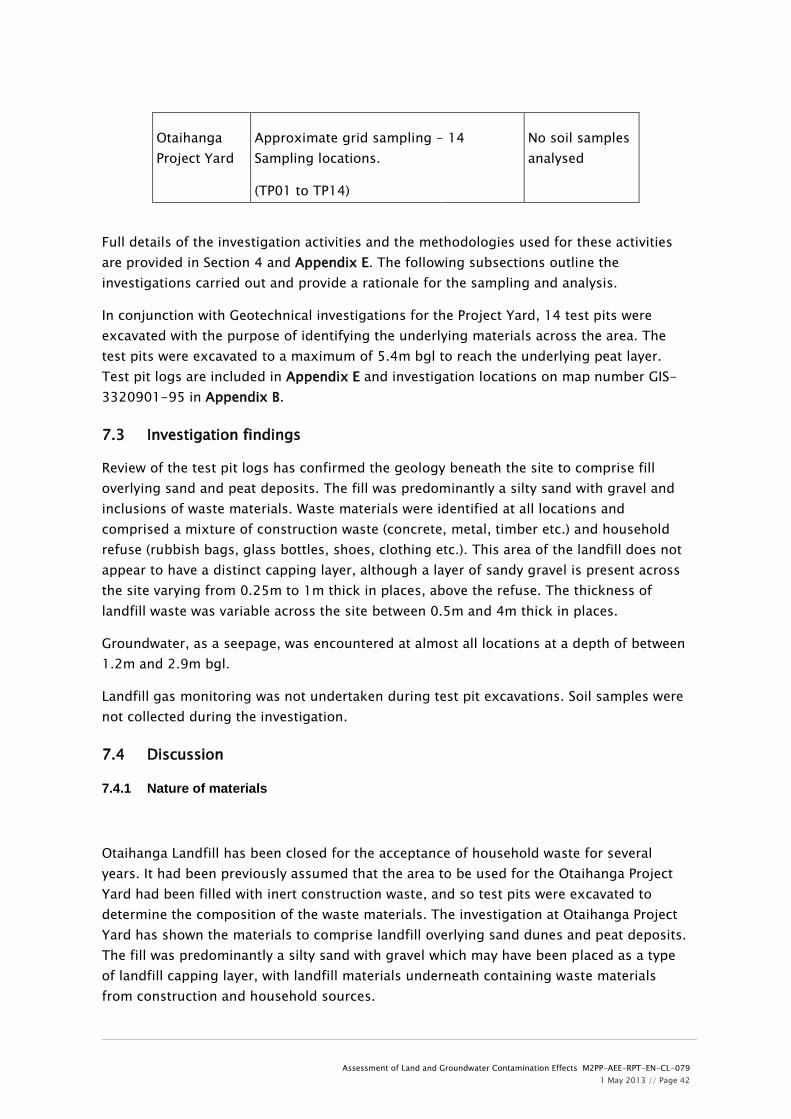
Assessment of Land and Groundwater Contamination Effects M2PP-AEE-RPT-EN-CL-079 1 May 2013 // Page 42
Otaihanga Project Yard
Approximate grid sampling - 14 Sampling locations.
(TP01 to TP14)
No soil samples analysed
Full details of the investigation activities and the methodologies used for these activities are provided in Section 4 and Appendix E. The following subsections outline the investigations carried out and provide a rationale for the sampling and analysis.
In conjunction with Geotechnical investigations for the Project Yard, 14 test pits were excavated with the purpose of identifying the underlying materials across the area. The test pits were excavated to a maximum of 5.4m bgl to reach the underlying peat layer. Test pit logs are included in Appendix E and investigation locations on map number GIS-3320901-95 in Appendix B.
7.3 Investigation findings
Review of the test pit logs has confirmed the geology beneath the site to comprise fill overlying sand and peat deposits. The fill was predominantly a silty sand with gravel and inclusions of waste materials. Waste materials were identified at all locations and comprised a mixture of construction waste (concrete, metal, timber etc.) and household refuse (rubbish bags, glass bottles, shoes, clothing etc.). This area of the landfill does not appear to have a distinct capping layer, although a layer of sandy gravel is present across the site varying from 0.25m to 1m thick in places, above the refuse. The thickness of landfill waste was variable across the site between 0.5m and 4m thick in places.
Groundwater, as a seepage, was encountered at almost all locations at a depth of between 1.2m and 2.9m bgl.
Landfill gas monitoring was not undertaken during test pit excavations. Soil samples were not collected during the investigation.
7.4 Discussion
7.4.1 Nature of materials
Otaihanga Landfill has been closed for the acceptance of household waste for several years. It had been previously assumed that the area to be used for the Otaihanga Project Yard had been filled with inert construction waste, and so test pits were excavated to determine the composition of the waste materials. The investigation at Otaihanga Project Yard has shown the materials to comprise landfill overlying sand dunes and peat deposits. The fill was predominantly a silty sand with gravel which may have been placed as a type of landfill capping layer, with landfill materials underneath containing waste materials from construction and household sources.

Assessment of Land and Groundwater Contamination Effects M2PP-AEE-RPT-EN-CL-079 1 May 2013 // Page 43
7.4.2 Assessment of human health and environmental risks
The planned construction works in this area comprise the placement of hardfill for levelling and truck movements, pile driving for pre-cast form beds, crane gantry rails and site sheds, excavation of dunes for driveway formation and services connections, and excavation of site drains. The dunes due to be excavated for the driveway are not anticipated to contain any landfill materials, as this area is outside the area of historical filling, and has mature pine trees established.
The excavations will be localised in specific areas and are likely to be less than 1m deep, and it is considered likely that refuse will be encountered beneath the sandy gravel layer during the excavations. The works are considered unlikely to intercept groundwater noted at 1.2m bgl at some locations within the Project Yard area. However, procedures are included in the CSGMP and CSMP(HH) for managing contaminated groundwater.
It has been assumed that landfill materials will be contaminated, and any materials excavated from this area will be treated as contaminated and managed and disposed of appropriately. Procedures are included in the CSGMP and CSMP(HH).
The CHSP will deal with health and safety procedures relating to potential landfill gas venting during the construction of the Project Yard.
The environmental risks from contaminants would result from discharge to groundwater and dispersal of contaminated soils during construction.
7.4.3 Assessment of discharge resource consent requirements
The definition of a contaminated site as given in the Discharges to Land Plan is as follows: “A site at which a hazardous substance occurs at concentrations above background levels and where assessment indicates it poses or is likely to pose an immediate or long term hazard to human health or the environment.”
It has been assumed that the landfill materials are likely to contain contaminants exceeding background levels and environmental risk criteria and/or human health criteria and so the Otaihanga Project Yard is classified as a contaminated site.
It is known that contaminants in leachate are discharging to surface water and groundwater from the landfill and that consent is already held by KCDC for this activity. It is anticipated that landfill materials during the construction of the Project Yard may be able to be retained on the landfill site. Excavation of soils for disposal to a licensed landfill would not require a discharge consent under Rule 22 of the Discharges to Land Plan.
7.4.4 Assessment of land use resource consent requirements
This land parcel is classified as a HAIL site for the following activity:
G5 – waste disposal to land.
The landfill area has been estimated at 502,000m2 and the whole land parcel has been conservatively considered as potentially contaminated. The maximum permitted volume of

Assessment of Land and Groundwater Contamination Effects M2PP-AEE-RPT-EN-CL-079 1 May 2013 // Page 44
disturbance at this site is therefore 25,000m3 per annum of which 5,020m3 can be disposed of off site, as a Permitted Activity. The volume of soil disturbance and disposal is unlikely to exceed these volumes, and excavated materials are unlikely to be disposed of off-site. The construction works are able to comply with the remaining Permitted Activity criteria.
7.4.5 Proposed mitigation of effects
Where materials are required to be excavated at Otaihanga Project Yard they should be disposed of to a licensed landfill to avoid on-going health risks. Consideration could be given as to whether materials could be disposed of elsewhere on the landfill site, in consultation with KCDC.
All excavations should be carried out and managed in accordance with the CSGMP, CSMP(HH) and CHSP. Adherence to such plans will control the off-site migration of any, as yet, unidentified contaminants and minimise the exposure of construction workers to contaminated soils.
7.5 Summary of effects and proposed mitigation
Based on the findings of the investigation for this sector, the potential effects on the environment are detailed in Table 12 below, along with appropriate mitigation measures:
Table 12 - Sector 3: Assessment of Environmental Effects
Area Effect Mitigation
Otaihanga Project Yard
Exposure of construction workers to contaminated soils (dermal contact, accidental ingestion, inhalation of dust)
Discharge of soil contaminants to air, land and surface water/groundwater during construction.
Excavation of contaminated soils and disposal to landfill.
Adherence to the CSGMP to prevent discharge of contaminants to land and discharge of contaminants to water.
Adherence to the CSMP(HH) to minimise exposure of construction workers to potentially contaminated soils.
Use of dust suppression controls as per CAQMP.
Use of erosion and sediment controls as per ESCP.
More detail on the mitigation measures to address the potential effects from the discharge of soil contaminants to air, land and water are provided within the CSGMP and CSMP(HH). The key measures are summarised in Section 9 of this report.

Assessment of Land and Groundwater Contamination Effects M2PP-AEE-RPT-EN-CL-079 1 May 2013 // Page 45
7.6 Conclusions
The investigations in Sector 3 have shown that soils comprise fill overlying sand dunes and peat deposits. The observed fill was predominantly a silty sand with gravel, overlying landfill materials at almost all locations at Otaihanga Project Yard.
Whilst no soil samples were collected during investigation of the Otaihanga Project Yard, it has been assumed that landfill materials are contaminated, and therefore the site has been classified as a contaminated site.
The construction works at Otaihanga Project Yard can comply with the Permitted Activity conditions of Regulation 8(3) of the NES.
Excavation of soils for disposal to a licensed landfill would not require a discharge consent under Rule 22 of the Discharges to Land Plan.
Potential environmental effects relate to the discharge of soil contaminants to groundwater, surface water and land during construction. Potential human health effects relate to the exposure of construction workers to contaminated soils and the inhalation of airborne soil contaminants by the public.
The effects can be mitigated by the excavation and disposal off-site of contaminated soils, containment of contaminants on site, compliance with discharge and human health resource consent conditions and adherence to management methods and procedures to protect human health and the environment detailed in the CSGMP, CSMP(HH), CAQMP and the ESCP.

Assessment of Land and Groundwater Contamination Effects M2PP-AEE-RPT-EN-CL-079 1 May 2013 // Page 46
8 Sector 4
8.1 Sector Description
Sector 4 runs from Te Moana Road to Peka Peka Beach Road. A new alignment to Ngarara Road will be built to cross the Expressway, which will include construction of an overbridge. Smithfield Road will be relocated to the south of its existing position, with an overbridge constructed to carry the new alignment over the Expressway. At the Peka Peka end, an interchange will be constructed over both the Expressway and the existing railway, linking Peka Peak Beach Road to Hadfield Road.
The generalised geological sequence beneath Sector 4 is expected to comprise sand dunes and peat swamps overlying sandy, gravelly alluvial deposits from the erosion of the mountainous greywacke terrain of the Tararua Ranges in the east.
Several waterways cross Sector 4 including the Waimeha Stream, the Ngarara Stream, the Ngarara Drain, the Kakariki Stream and the Paetawa Drain.
The current land use within this sector is rural, with predominantly pasture and some areas of bush.
8.2 Investigation Activities
There were no properties in Sector 4 identified in the desk study that were considered to have the potential to be contaminated from current or historical activities.
Assessment of Land and Groundwater Contamination Effects M2PP-AEE-RPT-EN-CL-079 1 May 2013 // Page 47
9 Summary of Proposed Mitigation Measures
The proposed mitigation measures for the effects from contaminants identified in the soils within the Project footprint are detailed in the CSGMP and CSMP(HH). The CSGMP addresses the potential adverse environmental effects and the CSMP(HH) addresses the potential human health effects of the Project in relation to contaminated soils and groundwater. The key mitigation measures are summarised below: Appointment of a Contaminated Land Specialist (CLS) during the construction phase of
the Project. The CLS will be available on site during all excavation works, and has responsibility for: Co-ordinating additional soil and groundwater testing; Advising on classification of excavated materials for reuse and disposal; Co-ordinating groundwater management and disposal; and Training of staff in contaminated land identification and control procedures.
A Construction Health & Safety Plan (CHSP) to detail procedures and protocols for mitigation of risks to construction workers and the general public during the excavation and handling of contaminated soils.
Excavation, where appropriate, and off-site disposal of soils containing contaminants or hazardous materials.
Containment of contaminants using cement stabilisation where soils are to be reused.
Monitoring of activities and receptors likely to be affected by discharges.
Management procedures for the excavation of contaminated soils, to include:
Handling and storage requirements (stockpiling to be limited where possible, contaminated materials posing a risk to human health to be loaded directly onto trucks);
Measures to control the discharge of contaminants to air, the discharge of contaminants to the land and discharge of contaminants to water (dust suppression and earthworks erosion and sediment controls); and
Disposal of contaminated soils to appropriately licensed landfill (including details of excavations, waste carrier records and retaining landfill documentation).
Procedures for identifying and managing unexpected discoveries of contamination.
Soil testing, to include:
Verification testing: confirmation of lateral and vertical extent of areas of contamination.
Validation testing: testing of materials left in situ following excavation of an area of contamination.
Discovery testing: testing of suspected contamination upon discovery.

Assessment of Land and Groundwater Contamination Effects M2PP-AEE-RPT-EN-CL-079 1 May 2013 // Page 48
Submission of a Site Validation Report at the completion of the construction works, detailing the procedures adopted to manage the contamination within the Project footprint.

Assessment of Land and Groundwater Contamination Effects M2PP-AEE-RPT-EN-CL-079 1 May 2013 // Page 49
10 Summary Conclusions
This contamination assessment has established the quality of soils at selected locations along the route of the Expressway. In addition, the potential environmental effects due to construction of the Project have been determined together with the necessary regulatory controls and mitigation. These are discussed in detail within the sector specific sections of this report and summarised below.
10.1 Investigation Summary
The contamination assessment comprised a range of investigations which have been detailed and discussed in the preceding sector specific sections of this report. The main findings of the assessment are summarised in the following sub sections which broadly define the following:
Where contaminated soils have been identified.
Where waste materials have been encountered.
Where a requirement for a discharge resource consent is triggered due to the migration of contaminants beyond the boundary of a contaminated site.
Where health risks to construction workers have been identified.
Where a requirement for a land use consent is triggered under the NES.
The environmental effects of the Project based on the investigation findings.
The mitigation required for the identified environmental and human health effects.
10.2 Soils
The proposed works associated with the Project will involve land disturbance within Sectors 1 to 4. Seven sites (two in Sector 1, four in Sector 2 and one in Sector 3) have been conservatively been identified as contaminated sites under the Discharges to Land Plan. Discharge resource consent is required for the reuse of soils under Rule 22 of the Discharges to Land Plan for these seven sites as contaminants could be migrating across the boundaries of the sites (see Table 13 below).
Six sites have been identified as HAIL sites: 16 Leinster Avenue, 150 Raumati Road, 55 & 61 Rata Road, 58 Kiwi Road and Otaihanga Project Yard.
Human health risks have been identified in soils at 55 Rata Road in Sector 2. Soil disturbance activities at this site will require a Restricted Discretionary consent under Regulation 10 of the NES. Soils containing levels of contaminants posing a risk to human health should be excavated and disposed of to landfill.
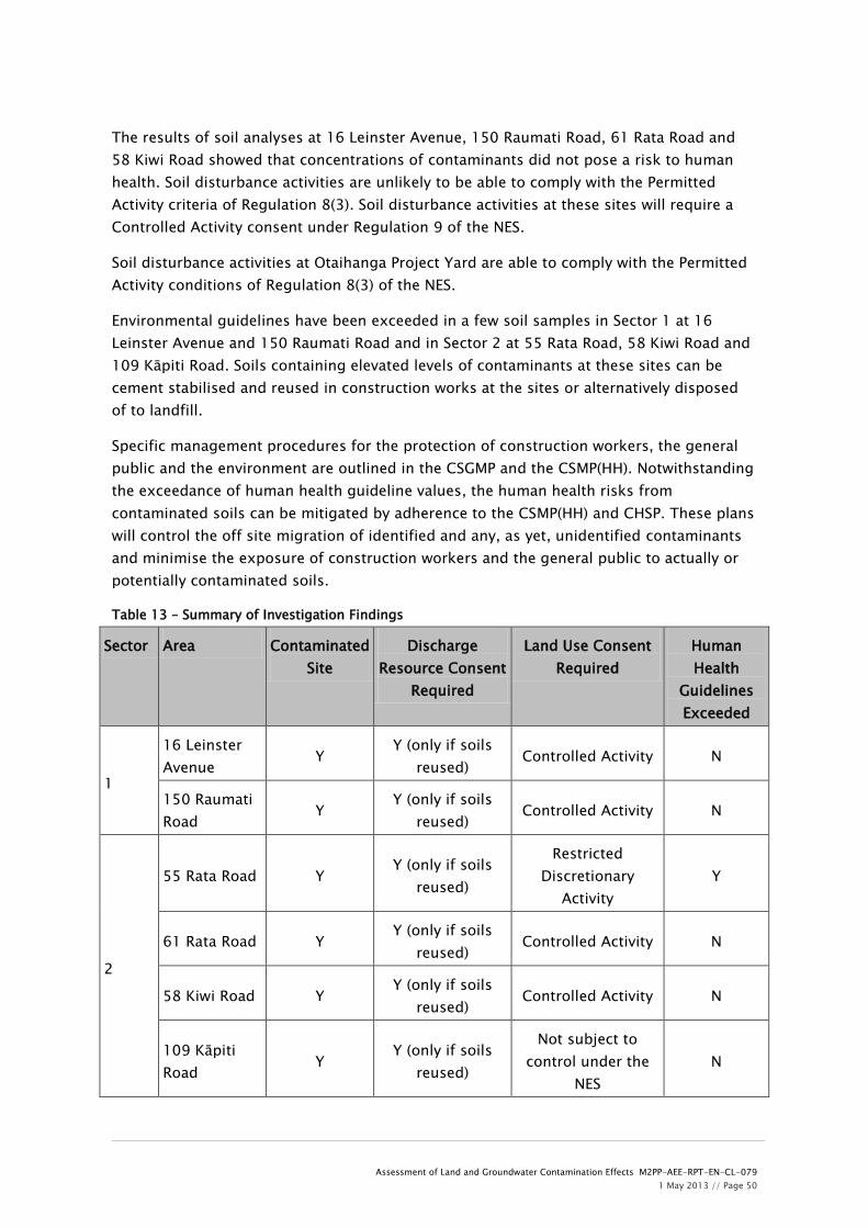
Assessment of Land and Groundwater Contamination Effects M2PP-AEE-RPT-EN-CL-079 1 May 2013 // Page 50
The results of soil analyses at 16 Leinster Avenue, 150 Raumati Road, 61 Rata Road and 58 Kiwi Road showed that concentrations of contaminants did not pose a risk to human health. Soil disturbance activities are unlikely to be able to comply with the Permitted Activity criteria of Regulation 8(3). Soil disturbance activities at these sites will require a Controlled Activity consent under Regulation 9 of the NES.
Soil disturbance activities at Otaihanga Project Yard are able to comply with the Permitted Activity conditions of Regulation 8(3) of the NES.
Environmental guidelines have been exceeded in a few soil samples in Sector 1 at 16 Leinster Avenue and 150 Raumati Road and in Sector 2 at 55 Rata Road, 58 Kiwi Road and 109 Kāpiti Road. Soils containing elevated levels of contaminants at these sites can be cement stabilised and reused in construction works at the sites or alternatively disposed of to landfill.
Specific management procedures for the protection of construction workers, the general public and the environment are outlined in the CSGMP and the CSMP(HH). Notwithstanding the exceedance of human health guideline values, the human health risks from contaminated soils can be mitigated by adherence to the CSMP(HH) and CHSP. These plans will control the off site migration of identified and any, as yet, unidentified contaminants and minimise the exposure of construction workers and the general public to actually or potentially contaminated soils.
Table 13 – Summary of Investigation Findings
Sector Area Contaminated Site
Discharge Resource Consent
Required
Land Use Consent Required
Human Health
Guidelines Exceeded
1
16 Leinster Avenue
Y Y (only if soils
reused) Controlled Activity N
150 Raumati Road
Y Y (only if soils
reused) Controlled Activity N
2
55 Rata Road Y Y (only if soils
reused)
Restricted Discretionary
Activity Y
61 Rata Road Y Y (only if soils
reused) Controlled Activity N
58 Kiwi Road Y Y (only if soils
reused) Controlled Activity N
109 Kāpiti Road
Y Y (only if soils
reused)
Not subject to control under the
NES N

Assessment of Land and Groundwater Contamination Effects M2PP-AEE-RPT-EN-CL-079 1 May 2013 // Page 51
3 Otaihanga Project Yard
Y N Permitted Activity N
10.3 Assessment of Environmental Effects and Mitigation
The sector specific environmental and human health effects that could result from the Project construction are summarised in Table 14 along with proposed mitigation measures.
Table 14 - Potential Environmental and Human Health Effects from Construction
Sector Area Effect Mitigation
2 55 Rata Road
Exposure of construction workers to contaminated soils (dermal contact, accidental ingestion, inhalation of dust)
Discharge of soil contaminants to air, land and surface water/groundwater during construction.
Excavation of contaminated soils posing a risk to human health and disposal to landfill.
Compliance with land use and discharge Resource Consent conditions.
Adherence to the CSGMP to prevent discharge of contaminants to land and discharge of contaminants to water.
Adherence to the CSMP(HH) to minimise exposure of construction workers to potentially contaminated soils.
Use of dust suppression controls as per CAQMP.
Use of erosion and sediment controls as per ESCP.
1 and 2
All other sites
Exposure of construction workers to potentially contaminated soils (dermal contact, accidental ingestion, inhalation of dust)
Discharge of soil contaminants to air, land and surface water/groundwater during construction.
Containment of contaminants using cement stabilisation or excavation and disposal to landfill.
Compliance with land use discharge Resource Consent conditions.
Adherence to the CSGMP to prevent discharge of contaminants to land and discharge of contaminants to water.
Adherence to the CSMP(HH) to

Assessment of Land and Groundwater Contamination Effects M2PP-AEE-RPT-EN-CL-079 1 May 2013 // Page 52
minimise exposure of construction workers to potentially contaminated soils.
Use of dust suppression controls as per CAQMP.
Use of erosion and sediment controls as per ESCP.
This assessment has identified contaminated soils and potentially hazardous materials within the Project footprint. However, these occur in relatively localised areas as defined in the table above. The environmental effects of the Project relate to discharge of soil contaminants to ground or surface water and land during earthworks. The human health effects of the Project relate to construction workers and general public exposure to soil contaminants. These effects can be mitigated by compliance with resource consents, containment of contaminants on site, excavation of contaminated soils and disposal off-site, and adherence to the CSGMP, CMSP(HH) and the CHSP.
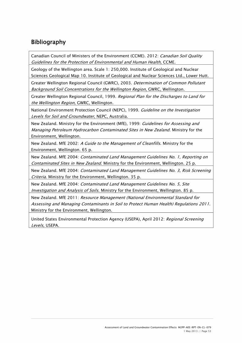
Assessment of Land and Groundwater Contamination Effects M2PP-AEE-RPT-EN-CL-079 1 May 2013 // Page 53
Bibliography
Canadian Council of Ministers of the Environment (CCME). 2012: Canadian Soil Quality Guidelines for the Protection of Environmental and Human Health, CCME. Geology of the Wellington area. Scale 1: 250,000. Institute of Geological and Nuclear Sciences Geological Map 10. Institute of Geological and Nuclear Sciences Ltd., Lower Hutt. Greater Wellington Regional Council (GWRC), 2003. Determination of Common Pollutant Background Soil Concentrations for the Wellington Region, GWRC, Wellington. Greater Wellington Regional Council, 1999. Regional Plan for the Discharges to Land for the Wellington Region, GWRC, Wellington. National Environment Protection Council (NEPC), 1999. Guideline on the Investigation Levels for Soil and Groundwater, NEPC, Australia. New Zealand. Ministry for the Environment (MfE), 1999: Guidelines for Assessing and Managing Petroleum Hydrocarbon Contaminated Sites in New Zealand. Ministry for the Environment, Wellington. New Zealand. MfE 2002: A Guide to the Management of Cleanfills. Ministry for the Environment, Wellington. 65 p. New Zealand. MfE 2004: Contaminated Land Management Guidelines No. 1, Reporting on Contaminated Sites in New Zealand. Ministry for the Environment, Wellington. 25 p. New Zealand. MfE 2004: Contaminated Land Management Guidelines No. 3, Risk Screening Criteria. Ministry for the Environment, Wellington. 35 p. New Zealand. MfE 2004: Contaminated Land Management Guidelines No. 5, Site Investigation and Analysis of Soils. Ministry for the Environment, Wellington. 85 p. New Zealand. MfE 2011: Resource Management (National Environmental Standard for Assessing and Managing Contaminants in Soil to Protect Human Health) Regulations 2011. Ministry for the Environment, Wellington.
United States Environmental Protection Agency (USEPA), April 2012: Regional Screening Levels, USEPA.

APPENDIX A
Regulatory Framework

The discharge of any contaminants:(1) into or onto land from a contaminated site, (and not from any activity located on
the site) other than as provided in clause (1) of Rule 22; or(2) into or onto land which is, or is part of, a contaminated site, in association with
the on-site remediation of the contaminated site;
is a provided(a) there shall be no noxious, dangerous, offensive or objectionable levels of
contaminants in the air at or beyond the site boundary as a result of thedischarge;
(b) there shall be no contaminants from the contaminated site or from anydischarge associated with site remediation (or any other contaminantsemanating as a result of natural processes from those contaminants) beyond theboundary of the contaminated site at concentrations above the backgroundlevels for that location;
(c) the site owner shall undertake such monitoring as is necessary to ensure thatthe site complies with conditions (a) and (b) above, and shall make themonitoring results available to the Wellington Regional Council, on request.
The discharge of any contaminants:(1) into or onto land from a contaminated site (and not from any activity located on
the site); or(2) into or onto land which is, or is part of, a contaminated site, in association with
the on-site remediation of the contaminated site;if:
(3) the activity involves the removal of material from the contaminated site and thedischarge of contaminated material at some other location (unless the materialis discharged at a landfill which holds resource consents which enable it toaccept the discharge); or
(4) the discharge does not comply with any of the conditions in Rule 21;
is a and shall comply with the standards and terms below.

(a) the consent holder shall undertake such monitoring as is necessary toensure that the site complies with conditions or standards set by theWellington Regional Council under provisions (i) and (ii) of this Rule, andshall make the monitoring results available to the Wellington RegionalCouncil, on request.
The Wellington Regional Council shall exercise control over:(1) any on-site actions that may be required in order to manage the actual or
potential effects of discharges of contaminants from the originating site or thedisposal site;
(2) standards for site remediation, if necessary;(3) the means of removal, and the location of the disposal, of any contaminated
material from the site;(4) the duration of the consent; and(5) administrative charges.
An application for a resource consent under Rule 22 shall be made on the prescribedform, and shall include:
(1) the matters set out in (1)-(8) of Section 5.3.1 of this Plan;(2) a summary of any site investigations that have been undertaken to determine
the degree and extent of the contamination, including an identification of theboundaries of the contaminated site;
(3) any remedial action planned for the site, and the actual and potential effects ofthe remedial action.
An application for a resource consent:• shall not be publicly notified; and• shall be considered without the written approval of affected persons;
except where the consent authority considers that there are exceptional circumstanceswhich justify notification of the obtaining of written approval from affected persons.

•
•