Assessment and Validation of AD-Functions3D Data Collection ... Test Vehicles for HAD Functions &...
26
IAE | Institute of Automotive Engineering, TU Braunschweig | Page 1 Member of Automotive Research Centre „Niedersachsen“ (NFF) Assessment and Validation of AD-Functions Investigation for Global Industry Harmonization Priv. Doz. Dr.-Ing. Roman Henze Vehicle Dynamics & Active Systems, Institute of Automotive Engineering TU Braunschweig Intelligent Vehicle & Connected Driving, Niedersächsisches Forschungszentrum Fahrzeugtechnik FAST-zero ‘19, September 9 th -11 th 2019, Blacksburg, VA, USA [email protected] - www.iae.tu-bs.de
Transcript of Assessment and Validation of AD-Functions3D Data Collection ... Test Vehicles for HAD Functions &...

IAE | Institute of Automotive Engineering, TU Braunschweig | Page 1
Member of Automotive Research Centre „Niedersachsen“ (NFF)
Assessment and Validation of AD-Functions Investigation for Global Industry Harmonization
Priv. Doz. Dr.-Ing. Roman Henze
Vehicle Dynamics & Active Systems, Institute of Automotive Engineering TU Braunschweig Intelligent Vehicle & Connected Driving, Niedersächsisches Forschungszentrum Fahrzeugtechnik
FAST-zero ‘19,
September 9th -11th 2019, Blacksburg, VA, USA
[email protected] - www.iae.tu-bs.de

IAE | Institute of Automotive Engineering, TU Braunschweig | Page 2
Member of Automotive Research Centre „Niedersachsen“ (NFF)
Assessment and Validation of AD-Functions Investigation for Global Industry Harmonization
Roman Henze
Satoshi Taniguchi
FAST-zero ‘19,
September 9th -11th 2019, Blacksburg, VA, USA

IAE | Institute of Automotive Engineering, TU Braunschweig | Page 3
Member of Automotive Research Centre „Nieofsachsen“ (NFF)
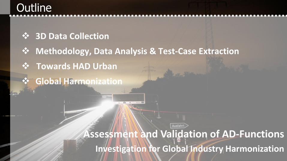
3D Data Collection
Methodology, Data Analysis & Test-Case Extraction
Towards HAD Urban
Global Harmonization
Outline
Assessment and Validation of AD-Functions
Investigation for Global Industry Harmonization

4
3D* Data Collection (Standard Equipment)
Intelligent
Power-Management
Main PC for
Dynamic Control,
Sensor Fusion,
HMI
BUS-Patchfield,
CAN-Gateways
RCP-Platform,
Datalogger
ADAS
Chassis
Powertrain
Comfort CAN
Vehicle Dynamics
Video Recording
Radar Signals
GPS-positions
„Labeling“-APP
Road Type
Traffic
Wheather
…
*3D = Driven Vehicle, Driver, Driving Environs

3D Data Collection – World Wide Measurements
Europe > 500.000 km > 8.000 hrs.
United States > 100.000 km > 2.500 hrs.
Japan > 100.000 km > 2.500 hrs.
China > 75.000 km > 1.500 hrs.
2018/19

3D Database Classification
DATABASE 1
> 10 Mio km
DATABASE 2
> 3.8 Mio km
DATABASE 3
~ 0.5 Mio km

Test Vehicles for HAD Functions & Referencing
TEASY III
6 Laser Scanners
for object detection
2 Lane Marking Scanners
Pre equipped radar and camera
Car-PC + RCP platform
*Testing and Engineering of Automated driving SYstems
TEASY3*

IAE | Institute of Automotive Engineering, TU Braunschweig | Page 8
Member of Automotive Research Centre „Niedersachsen“ (NFF)
HAD Approval in Real Driving Environs
3D Data Collection
Methodology, Data Analysis & Test-Case Extraction
Towards HAD Urban
Global Harmonization
Outline
Assessment and Validation of AD-Functions
Investigation for Global Industry Harmonization

HAD Test Process Development – Overview
Scenario Structure Schematic ofcription of relevant environment on different levels. Related to ego driving task. parameter definition. • Static Road Geometry • Dynamic object
Behavior and Motion
Methodology Process for the efficient Testing for • approval, • performance tests and • safety assessment of automated driving functions on highways.
Test-Case Identification Extraction process of relevant parameter specifications out of real environment databases. • Expected Cases (mean) • Corner-Cases (critical)
DATABASE

Scenario Structure
Safety Scenario
Sensors Environment Vehicle Stability
Influences on AD-System by
ego-behavior / Driving task
Dynamic (Traffic)
Static (Road Geometry)
object positions
object Behavior
Description of Influences on Decision Making
Perception Decision Making
Control AD-system 1 2 3

HD maps
Static Environment Information
3D-Scan Open-Street-Maps® • Frankfurt (A3, A5, A661) • Braunschweig, Hannover,
Salzgitter, Wolfsburg (A2, A7, A39)
• Tokio, Japan
Frankfurt
Online maps
Databases for Extraction
Tokyo
BS-H-SZ-WOB Dynamic Environment Information
Database 1
Database 2+3
Series Sensors, LIDAR • CAN • Video • dGPS
• Radar • Camera
• LIDAR
360° LIDAR (Object Detection)
Mono-Camera Front Radar

HD maps
Static Environment Information
3D-Scan Open-Street-Maps® • Frankfurt (A3, A5, A661) • Braunschweig, Hannover,
Salzgitter, Wolfsburg (A2, A7, A39)
• Tokio, Japan
Frankfurt
Online maps
Databases for Extraction
BS-H-SZ-WOB
modal 200 m 100 m
mean 224 m 131 m
min 95 m 20 m
max 1090 m 350 m
Tokyo

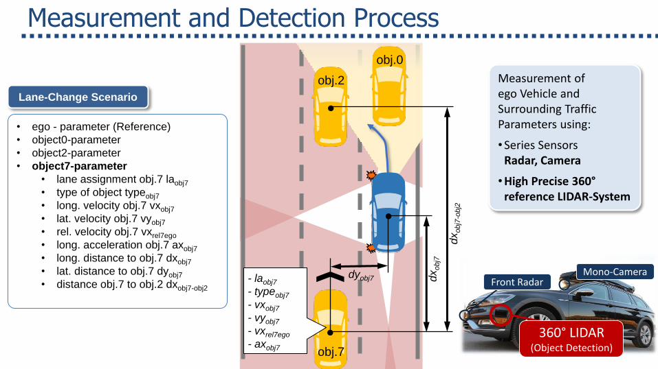
obj.0
obj.2
obj.7
Lane-Change Scenario
• ego - parameter (Reference)
• object0-parameter
• object2-parameter
• object7-parameter
• lane assignment obj.7 laobj7
• type of object typeobj7
• long. velocity obj.7 vxobj7
• lat. velocity obj.7 vyobj7
• rel. velocity obj.7 vxrel7ego
• long. acceleration obj.7 axobj7
• long. distance to obj.7 dxobj7
• lat. distance to obj.7 dyobj7
• distance obj.7 to obj.2 dxobj7-obj2
- laobj7
- typeobj7
- vxobj7
- vyobj7
- vxrel7ego
- axobj7
dyobj7
dx
obj7
-obj2
dx
obj7
Measurement of ego Vehicle and Surrounding Traffic Parameters using:
•Series Sensors Radar, Camera
•High Precise 360° reference LIDAR-System
Measurement and Detection Process
Mono Camera
360 -Laserscanner (Object Detection)
Front Radar
360° LIDAR (Object Detection)
Mono-Camera Front Radar

Environment Classification: Dynamic objects
ego
obj.2 obj.0
obj.1
obj.3
obj.7 obj.6 obj.8
Classification of object position Classification of object behavior
acceleration
decceleration
Cu
t-In
Cu
t-O
ut
sync.
Cut-In Cut-Out accl. deccl. sync..
Classification of object behavior
Cla
ssific
ation o
f positio
n
x – relevant for validation
(x) – relevant in combination
Cut-In Cut-Out accl. deccl. sync..
object 1
object 0
object 2
object 3
ego
object 6
object 7
object 8
Cut-In Cut-Out accl. deccl. sync..
object 1 x
object 0 x x x
object 2 x x x
object 3 x x x
ego
object 6 (x)
object 7 (x) (x) x
object 8 (x) (x) x
Cut-In Cut-Out accl. deccl. sync.
object 1 x
object 0 x x (x)
object 2 x x (x)
object 3 x x (x)
ego
object 6 (x)
object 7 (x) (x) (x)
object 8 (x) (x) (x)
obj.0
obj.2
obj.7
Lane-Change Scenario
• ego - parameter (Reference)
• object0-parameter
• object2-parameter
• object7-parameter
• lane assignment obj.7 laobj7
• type of object typeobj7
• long. velocity obj.7 vxobj7
• lat. velocity obj.7 vyobj7
• rel. velocity obj.7 vxrel7ego
• long. acceleration obj.7 axobj7
• long. distance to obj.7 dxobj7
• lat. distance to obj.7 dyobj7
• distance obj.7 to obj.2 dxobj7-obj2
- laobj7
- typeobj7
- vxobj7
- vyobj7
- vxrel7ego
- axobj7
dyobj7
dx
obj7
-obj2
dx
obj7
Measurement of ego Vehicle and Surrounding Traffic Parameters using:
•Series Sensors Radar, Camera
•High Precise 360° reference LIDAR-System
Measurement and Detection Process
Mono Camera
360 -Laserscanner (Object Detection)
Front Radar
360° LIDAR (Object Detection)
Mono-Camera Front Radar

Statistical Parameter Analysis
ego-related
vego axego
ego-object-related
vxobj/rel dxobj
object-related
vyobj axobj
Test-Case
Example: Different vxobj/rel/dxobj
combinations if the combinations depend on different ego velocities
Correlation tests for extraction of and parameter combinations!
realisitc
critical
Scenario-based
Parameters (dyn.)
cut-in distance [m]
max
. lat
. vel
oci
ty [
m/s
] re
l. lo
ng.
vel
oci
ty [
m/s
]
„Cut In“ Scenario
all data
TTC < 5s
dxobj vyobj vxobj/rel
Correlation

Test-Case Extraction from 3D Data Base
cut-in distance [m]
5% percentiles
2 24.5; 5.8
1 12.6; 3.2
n 61.4; 11.6
cut-in distance [m]
rel.
lon
g. v
elo
city
[m
/s]
Correlation r = 0,91 Test-Case
dxobj
[m]
vxobj/rel
[m/s] 5% percentile
…

3D Data Collection
Methodology, Data Analysis & Test-Case Extraction
Towards HAD Urban
Global Harmonization
Outline
Assessment and Validation of AD-Functions
Investigation for Global Industry Harmonization

Transfer of AD Validation in urban scenarios
stat. geometry ego
driving task dyn. objects
ofivation of relevant
scenarios Test-Case
Generation 2 3 Scenario Structure 1
surrounding traffic
1
0 2 3
4 5
7 6 8
ego
+ oncoming traffic
0
6
ego
9
10
crossing traffic +
ego ego
11 12
13 14
radius 0
6

derivation of relevant
scenarios Test-Case
Generation 2 3 Scenario Structure 1
Cut-in Crossing
traffic
U-Turn Lane change
Turning + Lane change
Turning
Openstreet map
data / HD-maps +
LIDAR Inner-City measurement campaigns
HD Data
stat.
geometry
ego driving
task
dyn. object
interactions
Transfer of AD Validation in urban scenarios

3D Data Collection
Methodology, Data Analysis & Test-Case Extraction
Towards HAD Urban
Global Harmonization
Outline
Assessment and Validation of AD-Functions
Investigation for Global Industry Harmonization
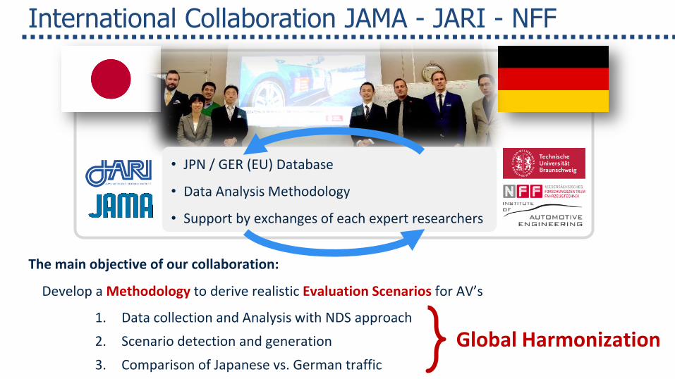
International Collaboration JAMA - JARI - NFF
The main objective of our collaboration:
Develop a Methodology to derive realistic Evaluation Scenarios for AV’s
1. Data collection and Analysis with NDS approach
2. Scenario detection and generation
3. Comparison of Japanese vs. German traffic
• JPN / GER (EU) Database
• Data Analysis Methodology
• Support by exchanges of each expert researchers
Global Harmonization

… significant country specific differences
o Occlusions, different Levels of Lanes o Left Hand Traffic o Speed Limits o Parameter Specifications o …
International JP-GER Collaboration – Current Activities
Ego
obj 2
Harmonization of • Processes • Scenario Structure and • Test-Case Identification But consider differences in relevant environment
Ego
obj 2

SAKURA - Project
The SAKURA project activities are led by JAMA
(Japanese Automobile Manufacturers Association) in collaboration with JARI (Japan Automobile Research Insitute), for which JARI is getting support from the
government (METI).
The project has been running since 2018

Thanks for your Attention!
Assessment and Validation of AD-Functions Investigation for Global Industry Harmonization
Assessment and Validation of AD-Functions Investigation for Global Industry Harmonization
FAST-zero ‘19, September 9th -11th 2019, Blacksburg, VA, USA