ASSESSING THE TRIGGERING RAINFALL-INDUCED ... THE...preventive measures. Varnes (1978) studied the...
17
European Journal of Geography Volume 4, Issue 3: 21-37 October 2013 © Association of European Geographers ASSESSING THE TRIGGERING RAINFALL-INDUCED LANDSLIP EVENTS IN THE SHIVKHOLA WATERSHED OF DARJILING HIMALAYA, WEST BENGAL. Sujit MANDAL Raja N. L. Khan Women’s College, Department of Geography, Paschim Medinipur, West Bengal, 721102, India [email protected] Ramkrishna MAITI Vidyasagar University, Department of Geography and Environment Management, Paschim Medinipur, West Bengal, 721102, India [email protected] Abstract Landslip events are triggered by the rainfall which causes a great damage to human lives and properties worldwide. The present study, encompasses the relationship between rainfall and landslide, the determination of the critical rain and its return period and the assessment of temporal probability of rainfall that triggers landslip events. Landslide inventory statistics were used to pertain the relationship between rainfall and landslip events. The continuous and uniform rate of minimum amount of rainfall (approx. less than 80 mm/day) for few consecutive days can cross the geomorphic threshold and can introduce slope instability in the Study area of Shivkhola Watershed. The critical rainfall for two major landslide locations i.e. Paglajhora and Tindharia were estimated incorporating geo-technical parameters such as angle of internal friction (φ), slope angle (Ѳ), upslope contributing area (UCA), transmissivity (T), wet soil density (ps), and density of water (pw). The return period of critical rain at various recurrence intervals were being assessed. At Lower Paglajhora the critical rainfall is 88.93mm which is less than the estimated rainfall of 90.54 mm/day at the recurrence interval of 1.01 year with 99% probability. The temporal probability of the landslide events were estimated applying Binomial and Poisson Probability Distribution Model based on historical landslip events since 1968. The probability model suggests that occurrences of major landslide events with more than 90 percent certainty could be expected in every 7.5 years. Keywords: Shivkhola Watershed; Landslides; Critical rainfall; Return period; Antecedent rainfall; Probability Model. 1. INTRODUCTION Geomorphic threshold is the significant parameter in analyzing the stability condition of a particular spatial unit in a quantitative way. According to White et al., (1996) ‘the minimum or maximum level of some quantity needed for a process to take place or a state to change is generally defined as threshold’. Brunsden et al., 1981; Wagner 1983; Manandhar and Khanal, 1988; Dhital et al., 1993; JICA, 1993; Upreti and Dhital, 1996; Gerrard and Gardner, European Journal of Geography - ISSN 1792-1341 © All rights reserved
Transcript of ASSESSING THE TRIGGERING RAINFALL-INDUCED ... THE...preventive measures. Varnes (1978) studied the...
European Journal of Geography Volume 4, Issue 3: 21-37 October 2013 © Association of European Geographers
ASSESSING THE TRIGGERING RAINFALL-INDUCED LANDSLIP EVENTS IN THE SHIVKHOLA WATERSHED OF DARJILING HIMALAYA, WEST BENGAL.
Sujit MANDAL
Raja N. L. Khan Women’s College, Department of Geography, Paschim Medinipur, West Bengal, 721102, India [email protected]
Ramkrishna MAITI
Vidyasagar University, Department of Geography and Environment Management, Paschim Medinipur, West Bengal, 721102, India
Abstract Landslip events are triggered by the rainfall which causes a great damage to human lives and properties worldwide. The present study, encompasses the relationship between rainfall and landslide, the determination of the critical rain and its return period and the assessment of temporal probability of rainfall that triggers landslip events. Landslide inventory statistics were used to pertain the relationship between rainfall and landslip events. The continuous and uniform rate of minimum amount of rainfall (approx. less than 80 mm/day) for few consecutive days can cross the geomorphic threshold and can introduce slope instability in the Study area of Shivkhola Watershed. The critical rainfall for two major landslide locations i.e. Paglajhora and Tindharia were estimated incorporating geo-technical parameters such as angle of internal friction (φ), slope angle (Ѳ), upslope contributing area (UCA), transmissivity (T), wet soil density (ps), and density of water (pw). The return period of critical rain at various recurrence intervals were being assessed. At Lower Paglajhora the critical rainfall is 88.93mm which is less than the estimated rainfall of 90.54 mm/day at the recurrence interval of 1.01 year with 99% probability. The temporal probability of the landslide events were estimated applying Binomial and Poisson Probability Distribution Model based on historical landslip events since 1968. The probability model suggests that occurrences of major landslide events with more than 90 percent certainty could be expected in every 7.5 years. Keywords: Shivkhola Watershed; Landslides; Critical rainfall; Return period; Antecedent rainfall; Probability Model.
1. INTRODUCTION
Geomorphic threshold is the significant parameter in analyzing the stability condition of a particular spatial unit in a quantitative way. According to White et al., (1996) ‘the minimum or maximum level of some quantity needed for a process to take place or a state to change is generally defined as threshold’. Brunsden et al., 1981; Wagner 1983; Manandhar and Khanal, 1988; Dhital et al., 1993; JICA, 1993; Upreti and Dhital, 1996; Gerrard and Gardner,
European Journal of Geography - ISSN 1792-1341 © All rights reserved
Mandal S.- Maiti R. / European Journal of Geography
2000; Dhital, 2003; Dahal et al. 2006a, while other works, such as Caine and Mool (1983), Dhakal et al. (1999), and Scott Wilson (2003) focused mainly on landslide risk assessment in Himalayan terrain assessing physical properties of landslides and debris flows, effects of regional and local geological settings, and recommendations for environmental-friendly preventive measures. Varnes (1978) studied the role of minimum intensity and duration of rainfall to cause a landslide of shallow soil slips, debris flows, debris slides or slumps. Crozier (1997) opined a maximum threshold, beyond which there is 100% chances of occurrences of the process at any time when the threshold value is exceeded. Starkel (1972) for the first time, observed the geomorphic effects of an extreme rainfall event in the eastern Himalaya (Darjiling). Froehlich et al., (1990) investigated the same area (Darjiling Himalaya) and found that shallow slides and slumps on steep slope segments occur when 24 hours rainfall reaches 130-150 mm or continuous three days rainfall totals 180-200 mm. Campbell, 1975; Cotecchia, 1978; Caine, 1980; Innes, 1983; Pomeroy, 1984; Canon and Ellen, 1985; Neary and Swift, 1987; Keefer et al., 1987; Kim et al., 1991; Li and Wang, 1992; Larsen and Simon, 1993; Wilson et al., 1995; Wieczorek, 1987, 1996, 2000; Terlien, 1997, 1998; Crosta, 1998; Crozier, 1999; Glade et al., 2000; Aleotti, 2004; Guzzetti et al., 2004, 2007; Hong et al., 2005; and Zezere et al., 2005 tried to establish rainfall-intensity thresholds for predicting the slope failure accurately. Caine (1980) for the first time established worldwide rainfall threshold values for landslides. Recently Guzzetti et al., (2007) reviewed rainfall thresholds for the initiation of landslides worldwide and proposed new empirical thresholds based on the statistical analysis of the relationship between rainfall and landslide occurrences. They defined intensity-duration threshold as: Where, I is the hourly rainfall intensity in millimeters (mm hr-1) and D is duration in hours.
The history of the landslide events in the Shivkhola watershed, Darjiling Himalaya shows that most of the landslide occurred as a result of heavy and continuous downpour for few days. Researchers (Ghosh, 1950; Nautiyal, 1951, 1966; Dutta et al, 1966; Roy and Sensharma, 1967; Basu, 1985, 1987 and 2001; Verma, 1972; Paul, 1973; Sinha, 1975; Chatterjee, 1983; Sengupta, 1995; Basu and De, 2003; Pal, 2006; Maiti, 2007; Ghosh, 2009b; and Sarkar, 2011) carried out a demand oriented studies in Darjiling Himalaya and identified the causes and consequences of major landslide occurrences phenomena. Only one concentrated 50 mm showers/hour during monsoon may initiate slope failure and that endangers innumerable people and their properties. The instability of landslide increases due to progressive absorption of moisture from excessive rainfall and cutting of hill slope both artificially and naturally together that makes the drainage inefficient.
Since 1968, the Shivkhola watershed faced 128 approachable landslide events till 2011 and among of them 76 events had been treated as reactivated (not 70m away from old slided area) and 52 as fresh events (70m away from the old slided area). The total landslide events took place in 16 years and out of which 12 years were recognized as the major landslide event years. Study suggested that except earthquake-induced landslide all the events occurred during the monsoon period with continuous and heavy showers which were more than the critical rainfall calculated after Borga et.al. (1998). Most of the landslide events were also closely associated with physiographic configuration, proximity to the weaknesses planes and weak lithological compositions. Yet, there is no ‘universal threshold value’ for the initiation of landslide phenomena. Because, landslide not only depends on one single parameter but also on others geomorphic and geo-hydrologic attributes. The study identified that only 105.88mm and 88.928mm daily rainfall was the critical rain for initiation of slide at two
European Journal of Geography - ISSN 1792-1341 © All rights reserved

Mandal S.- Maiti R. / European Journal of Geography
major landslide prone areas i.e. Tindharia and Lower Paglajhora respectively. So there is an every possibility for the generation of geomorphic threshold for initiation of landslide and there is a frequent occurrence of debris slide which will reduce the slope angle on landslide scar face to that of repose angle to attain temporary stability through internal feed back in a process of homeostatic adjustment. The study thrusts on the relationship between antecedent rainfall and landslide events, estimation of critical rainfall after Borga et al. (1998) and its return period for Paglajhora and Tindharia, and the application of the ‘poisson’ and ‘Binomial’ probability distribution model to estimate the temporal probability of landslide events in the Shivkhola Watershed. The study area, Shivkhola Watershed (Fig.1) is located in the southern escarpment slope of Darjiling Himalaya and is attributed with the landslide dynamicity (Fig.2, 3 & 4), mainly at the places of Paglajhora and Tindharia.
Figure 1. Locational map of the Shiv-khola Watershed
2. MATERIALS AND METHODS
2.1. Relationship Between Rainfall and Landslide Events Drainage basin is a proper spatial scale for analyzing hydrological parameters like input of rainfall and resultant output of discharge in a systematic interactive combination with other topographic and geometric attributes (Chorley, 1969; Strahler, 1957). Amount of rainfall is one of the triggering factors for slope instability because it affects surface run-off, infiltration, depth of the saturated soil and thus influences soil-moisture condition, cohesion and angle of internal friction. Infiltration and evapotranspiration are considered as the important hydrological parameters that determine slope instability. The hydrologic factors like daily rainfall threshold in connection with slope angle and regolith thickness (Gabet et.al.2004), rain fall intensity, infiltration (Schumm, 1983) etc. are given due importance in the analysis of slope instability. In the Shivkhola watershed the amount of rainfall increases from the month of May and it reaches peak in July then it starts decreasing and reaches minimum in December-January.
European Journal of Geography - ISSN 1792-1341 © All rights reserved
Mandal S.- Maiti R. / European Journal of Geography
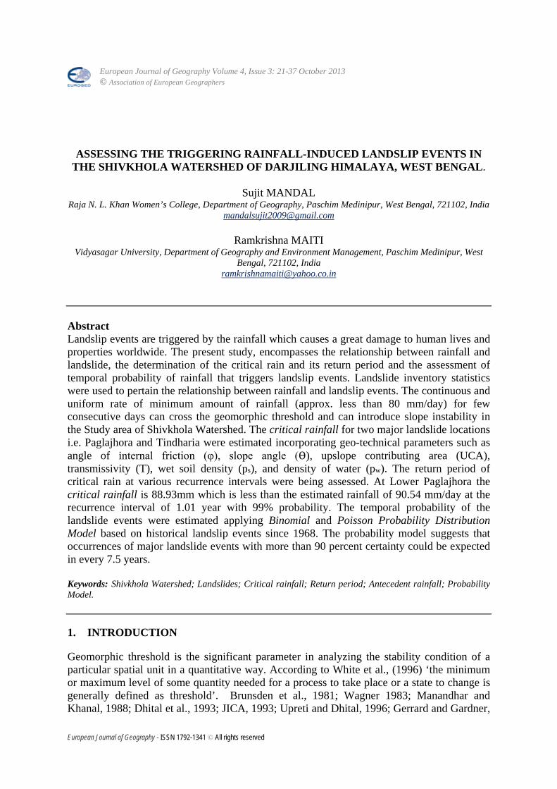
Figure 2, 2a, 2b, 2c, 3, 3a, 3b, 4 Analysis of monthly average rainfall since 1979 to 2010 reveals that the months of June,
July, August and September were registered with rainfall of more than normal (between third quartile-Q3 and first quartile-Q1) and average. On the other hand below average rainfall was being found mostly in the months of October, November, December, January, February and March. July and August were the most consistent rainfall months [Table.1] of the year where the values of co-efficient of variation were very low (37 and 30). These two months were also characterized by the catastrophic rainfall months because of the frequent occurrences of landslide events due to few days’ continuous rainfall. The picturesque slope failure took place in the Shivkhola watershed due to catastrophic rainfall in the month of July of 1985, 1989, 1992, 1993, 1998, 2002, 2003, 2004 and 2006. Rainfall induced slope failure also occurred in September 1980, 2006, July 2007, August 2007, August 2010.
Table.1. Statistical analysis of Monthly average rainfall since 1979-2010. Months J F M A M J J A S O N D Mean 13 17 43 95 302 728 996 784 588 183 12 23 S.D. 23 20 48 60 173 304 364 236 170 154 18 61 C.V. 176 117 111 63 57 41 37 30 28 84 150 97
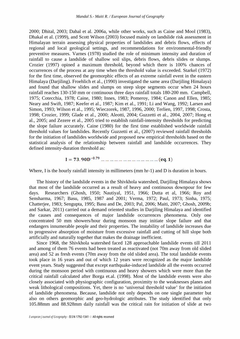
The yearly average rainfall since 1979 to 2009 also stated that the year 1978, 1980, 1981,
1984, 1985, 1989, 1990, 1991, 1998, 1999, 2000, 2003, 2005, 2006 and 2007 were the year of above average rainfall (317.75 mm). The symbolic red line in Fig.5 shows successive three years average rainfall conditions of 32 years which also helps to understand the effects of climate on ground-water condition, because the latter are influenced by the rainfall of the preceding two years. The devastating landslide occurrence in the 1984 and 85, 1987, 1988, 1999, 2000, 2003, 2005, 2006, and 2009 were associated with the preceding years increasing trend of successive three years average rainfall (Fig.5). So, the landslide phenomena in the Shivkhola watershed were closely related with the cumulative effects of precipitation and the changing nature of ground-water condition. In the present work, an simple assessment was made on antecedent rain prior to the landslides date for the month of July’ 1993, 1998, 2003, 2007 and 2010 on the basis of collected day wise rainfall from nearby Selim Hill Tea Estate.
European Journal of Geography - ISSN 1792-1341 © All rights reserved
Mandal S.- Maiti R. / European Journal of Geography
Figure 5.
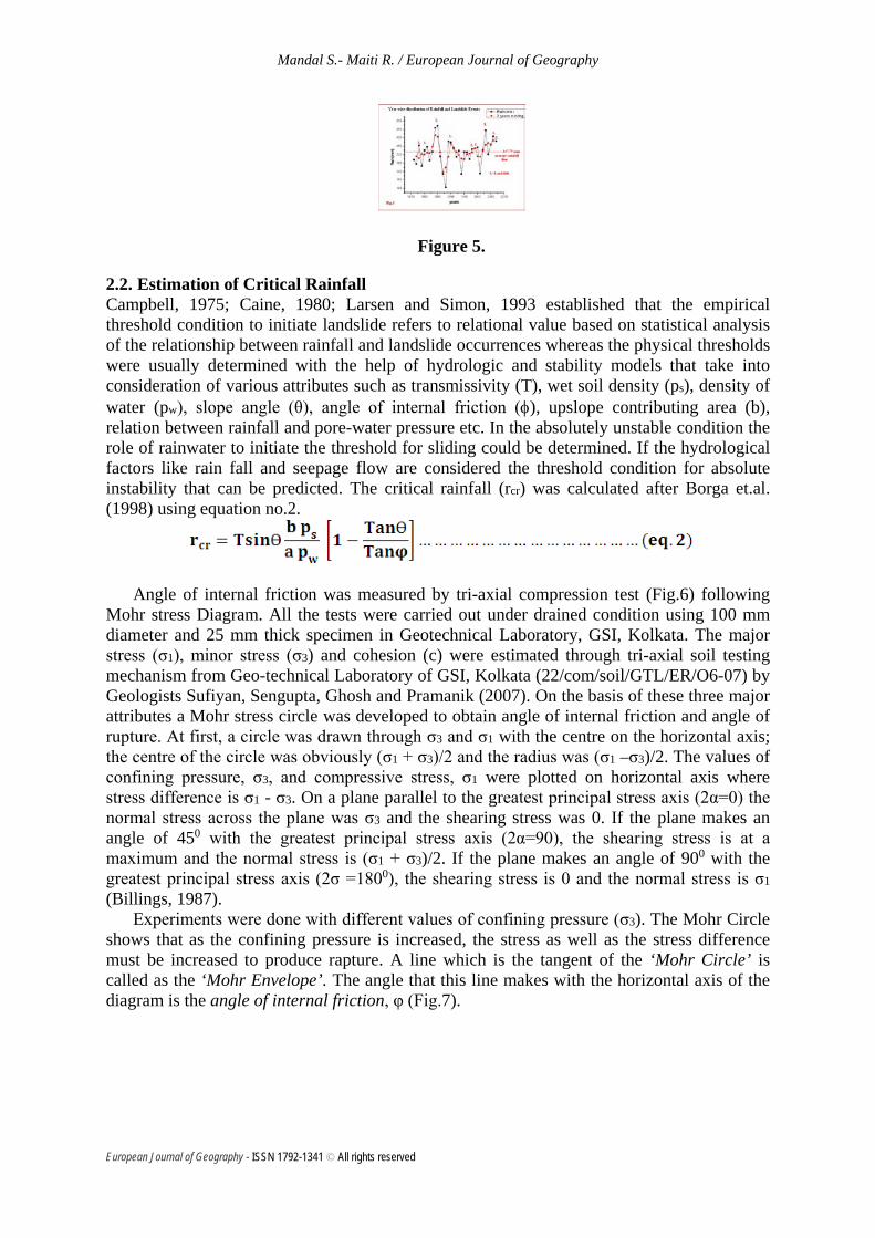
2.2. Estimation of Critical Rainfall Campbell, 1975; Caine, 1980; Larsen and Simon, 1993 established that the empirical threshold condition to initiate landslide refers to relational value based on statistical analysis of the relationship between rainfall and landslide occurrences whereas the physical thresholds were usually determined with the help of hydrologic and stability models that take into consideration of various attributes such as transmissivity (T), wet soil density (ps), density of water (pw), slope angle (θ), angle of internal friction (φ), upslope contributing area (b), relation between rainfall and pore-water pressure etc. In the absolutely unstable condition the role of rainwater to initiate the threshold for sliding could be determined. If the hydrological factors like rain fall and seepage flow are considered the threshold condition for absolute instability that can be predicted. The critical rainfall (rcr) was calculated after Borga et.al. (1998) using equation no.2.
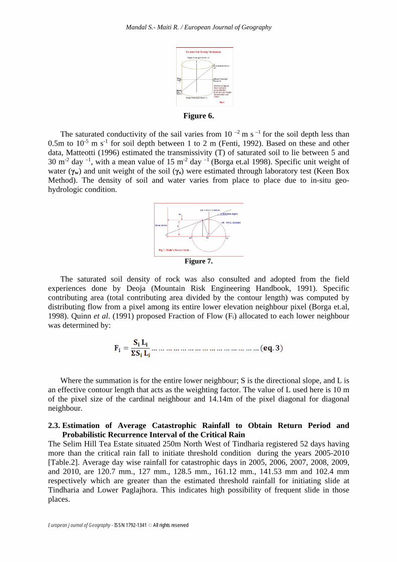
Angle of internal friction was measured by tri-axial compression test (Fig.6) following Mohr stress Diagram. All the tests were carried out under drained condition using 100 mm diameter and 25 mm thick specimen in Geotechnical Laboratory, GSI, Kolkata. The major stress (σ1), minor stress (σ3) and cohesion (c) were estimated through tri-axial soil testing mechanism from Geo-technical Laboratory of GSI, Kolkata (22/com/soil/GTL/ER/O6-07) by Geologists Sufiyan, Sengupta, Ghosh and Pramanik (2007). On the basis of these three major attributes a Mohr stress circle was developed to obtain angle of internal friction and angle of rupture. At first, a circle was drawn through σ3 and σ1 with the centre on the horizontal axis; the centre of the circle was obviously (σ1 + σ3)/2 and the radius was (σ1 –σ3)/2. The values of confining pressure, σ3, and compressive stress, σ1 were plotted on horizontal axis where stress difference is σ1 - σ3. On a plane parallel to the greatest principal stress axis (2α=0) the normal stress across the plane was σ3 and the shearing stress was 0. If the plane makes an angle of 450 with the greatest principal stress axis (2α=90), the shearing stress is at a maximum and the normal stress is (σ1 + σ3)/2. If the plane makes an angle of 900 with the greatest principal stress axis (2σ =1800), the shearing stress is 0 and the normal stress is σ1
(Billings, 1987). Experiments were done with different values of confining pressure (σ3). The Mohr Circle
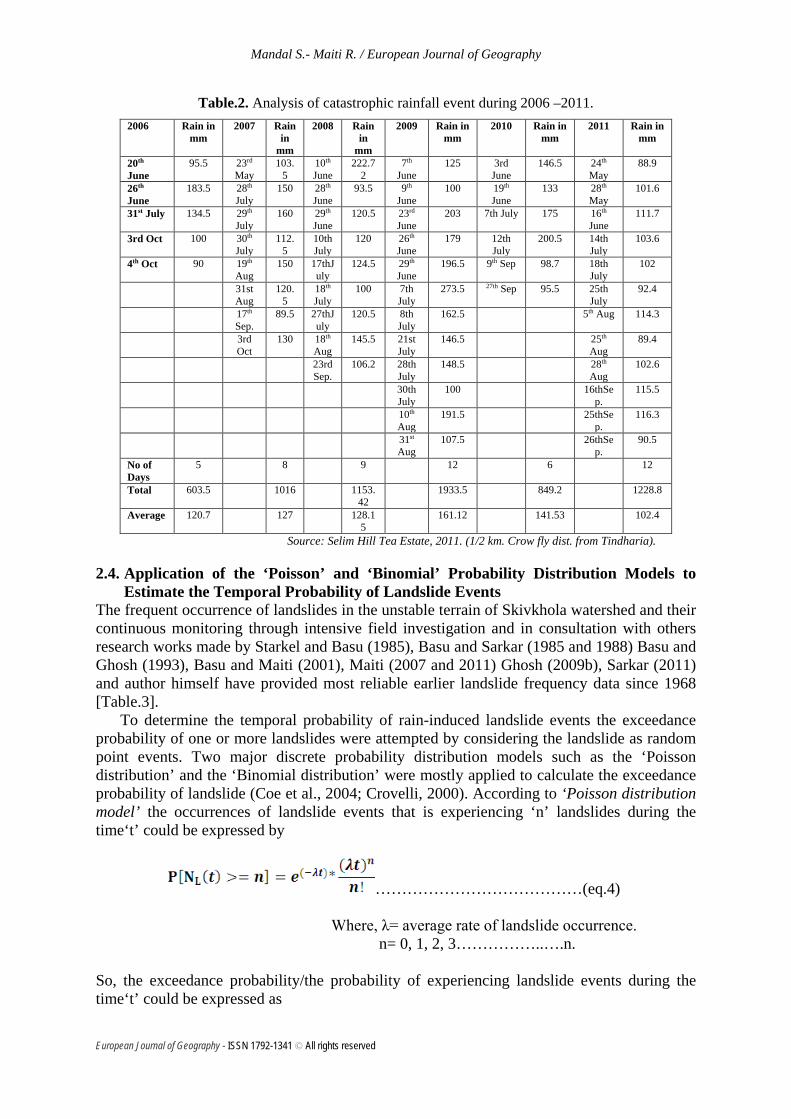
shows that as the confining pressure is increased, the stress as well as the stress difference must be increased to produce rapture. A line which is the tangent of the ‘Mohr Circle’ is called as the ‘Mohr Envelope’. The angle that this line makes with the horizontal axis of the diagram is the angle of internal friction, φ (Fig.7).
European Journal of Geography - ISSN 1792-1341 © All rights reserved
Mandal S.- Maiti R. / European Journal of Geography
Figure 6.
The saturated conductivity of the sail varies from 10 –2 m s –1 for the soil depth less than
0.5m to 10-5 m s-1 for soil depth between 1 to 2 m (Fenti, 1992). Based on these and other data, Matteotti (1996) estimated the transmissivity (T) of saturated soil to lie between 5 and 30 m-2 day –1, with a mean value of 15 m-2 day –1 (Borga et.al 1998). Specific unit weight of water (γw) and unit weight of the soil (γs) were estimated through laboratory test (Keen Box Method). The density of soil and water varies from place to place due to in-situ geo-hydrologic condition.
Figure 7.
The saturated soil density of rock was also consulted and adopted from the field
experiences done by Deoja (Mountain Risk Engineering Handbook, 1991). Specific contributing area (total contributing area divided by the contour length) was computed by distributing flow from a pixel among its entire lower elevation neighbour pixel (Borga et.al, 1998). Quinn et al. (1991) proposed Fraction of Flow (Fi) allocated to each lower neighbour was determined by:
Where the summation is for the entire lower neighbour; S is the directional slope, and L is an effective contour length that acts as the weighting factor. The value of L used here is 10 m of the pixel size of the cardinal neighbour and 14.14m of the pixel diagonal for diagonal neighbour.
2.3. Estimation of Average Catastrophic Rainfall to Obtain Return Period and Probabilistic Recurrence Interval of the Critical Rain
The Selim Hill Tea Estate situated 250m North West of Tindharia registered 52 days having more than the critical rain fall to initiate threshold condition during the years 2005-2010 [Table.2]. Average day wise rainfall for catastrophic days in 2005, 2006, 2007, 2008, 2009, and 2010, are 120.7 mm., 127 mm., 128.5 mm., 161.12 mm., 141.53 mm and 102.4 mm respectively which are greater than the estimated threshold rainfall for initiating slide at Tindharia and Lower Paglajhora. This indicates high possibility of frequent slide in those places.
European Journal of Geography - ISSN 1792-1341 © All rights reserved
Mandal S.- Maiti R. / European Journal of Geography
Table.2. Analysis of catastrophic rainfall event during 2006 –2011. 2006 Rain in
mm 2007 Rain
in mm
2008 Rain in
mm
2009 Rain in mm
2010 Rain in mm
2011 Rain in mm
20th June
95.5 23rd May
103.5
10th June
222.72
7th June
125 3rd June
146.5 24th May
88.9
26th June
183.5 28th July
150 28th June
93.5 9th June
100 19th June
133 28th May
101.6
31st July 134.5 29th July
160 29th June
120.5 23rd June
203 7th July 175 16th June
111.7
3rd Oct 100 30th July
112.5
10th July
120 26th June
179 12th July
200.5 14th July
103.6
4th Oct 90 19th Aug
150 17thJuly
124.5 29th June
196.5 9th Sep 98.7 18th July
102
31st Aug
120.5
18th July
100 7th July
273.5 27th Sep 95.5 25th July
92.4
17th Sep.
89.5 27thJuly
120.5 8th July
162.5 5th Aug 114.3
3rd Oct
130 18th Aug
145.5 21st July
146.5 25th Aug
89.4
23rd Sep.
106.2 28th July
148.5 28th Aug
102.6
30th July
100 16thSep.
115.5
10th Aug
191.5 25thSep.
116.3
31st
Aug 107.5 26thSe
p. 90.5
No of Days
5 8 9 12 6 12
Total 603.5 1016 1153.42
1933.5 849.2 1228.8
Average 120.7 127 128.15
161.12 141.53 102.4
Source: Selim Hill Tea Estate, 2011. (1/2 km. Crow fly dist. from Tindharia).
2.4. Application of the ‘Poisson’ and ‘Binomial’ Probability Distribution Models to Estimate the Temporal Probability of Landslide Events
The frequent occurrence of landslides in the unstable terrain of Skivkhola watershed and their continuous monitoring through intensive field investigation and in consultation with others research works made by Starkel and Basu (1985), Basu and Sarkar (1985 and 1988) Basu and Ghosh (1993), Basu and Maiti (2001), Maiti (2007 and 2011) Ghosh (2009b), Sarkar (2011) and author himself have provided most reliable earlier landslide frequency data since 1968 [Table.3].
To determine the temporal probability of rain-induced landslide events the exceedance probability of one or more landslides were attempted by considering the landslide as random point events. Two major discrete probability distribution models such as the ‘Poisson distribution’ and the ‘Binomial distribution’ were mostly applied to calculate the exceedance probability of landslide (Coe et al., 2004; Crovelli, 2000). According to ‘Poisson distribution model’ the occurrences of landslide events that is experiencing ‘n’ landslides during the time‘t’ could be expressed by
…………………………………(eq.4) Where, λ= average rate of landslide occurrence. n= 0, 1, 2, 3……………..….n. So, the exceedance probability/the probability of experiencing landslide events during the time‘t’ could be expressed as
European Journal of Geography - ISSN 1792-1341 © All rights reserved
Mandal S.- Maiti R. / European Journal of Geography
…………….(eq.5) Where, and 𝝁𝝁 = mean recurrence interval between successive landslide events. In the same way, the exceedance probability could be assessed by using the binomial probability distribution model with the help of following expression.
…….(eq.6)
To estimate the temporal probability of the landslide events in the Shivkhola watershed, the mean recurrence interval of known landslide events year was deduced that is 2.75 (16 known events year in 44 years). In the same way, mean recurrence interval of known major landslide events was also deduced that that is 3.66 (12 major events year in 44 years). Then, both Poisson and Binomial distribution models were being applied to determine the exceedance probability.
3. RESULT AND DISCUSSION
The thickness of the soil and that of the saturated soil during monsoon were measured to be 4.5m (Tindharia T.E.) and 7.25m (Lower Paglajhora). The wet soil buck density was measured to be 1.96 g/cc and density of water was 1.07 g/cc. The angle of internal friction varies from 210 to 260 with an average of 240. The upslope contributing area and contour length was 968 m2 and 22.00 m of Paglajhora and 1404 m2 and 27.00 m of Tindharia respectively. The slope angle at Paglajhora was 48020′ and Tindharia was 53020′. The basic requirement for the short term stability of the slope at marginal escarpment of Tindharia and Lower Paglajhora are to maintain the slope angle to be around 240. A steep slope will decline by slope failure to an angle of repose slope to attain short term stability. This concept leads to the concept of limiting or Threshold slope angle. The calculated critical/threshold rainfall of two major landslide prone parts of the Shivkhola watershed wer 105.88mm/day (Tindharia T.E.) and 88.93mm/day [Lower Paglajhora]. The friction angle (φ) in connection to the critical rainfall was assessed from the following two Stress circles (Fig.8 & 9).
A relationship between antecedent cumulative rainfall and landslide vents of 1993, 1998, 2003, 2007 and 2010 was established on the basis of the data recorded from earlier research work done by Ghosh et al. (2009b); Basu et al. (2000) and the collection of rainfall data from nearby Selim Hill Tea Estate by author himself. Only two days antecedent cumulative rainfall of 211.3 mm invited the slope failure at the places of Tindharia and Gayabari and Mahanadi. The 1998 landslide event took place due to 300-600 mm cumulative rainfall in the past 2/3 days only. The two days’ antecedent cumulative rainfall of 390 mm was responsible for 1998 landslide events. The major event of 2003 happened due to incessant rainfall of 500 mm in 2 days. 17th and 18th July, 2007 received rainfall of 124.5 mm and 100 mm respectively.
European Journal of Geography - ISSN 1792-1341 © All rights reserved
Mandal S.- Maiti R. / European Journal of Geography
Figure 8.
Figure 9.
These two days’ antecedent cumulative rainfall of 224.5 mm caused havoc slope failure
at Tindharia and Upper and Lower Paglajhora. Again 2007 faced landslide events on 8th September when 6th, 7th and 8th September’s antecedent cumulative rainfall amount was 275 mm. In 2010, major and prominent landslide events happened as a result of 5 days’ rainfall of 345 mm at 14 Mile near lower Paglajhora, Nurbong, Gitingia, Shiviter [Table.4]. Antecedent Cumulative rainfall induced landslide analysis shows that the continuous and uniform rate of minimum amount of rainfall (approx. less than 80 mm/day) for few consecutive days can cross the geomorphic threshold and can introduce slope instability condition.
Table.4. Major landslide events and 5 days antecedent cumulative rainfall. Landslide events Location
1 day 2 day 3 day 4 day 5 day
Tindharia and Gayabari and Mahanadi.
110mm
211.3 mm 265 mm 305 mm 340 mm
2nd July, 1993 3RD July, 1993 [Landslide]
Chunabhati, Tidharia, 150 390 450 485 520
European Journal of Geography - ISSN 1792-1341 © All rights reserved

Mandal S.- Maiti R. / European Journal of Geography
Paglajhora, Mahanadi (along NH-55), Jogmaya
6th July, 1998 7th July [Landslide]
8th July [Landslide]
Gayabari T.E., Along NH-55, Tindharia and Shiviter. Paglajhora,
197 mm. 500 mm. 527 565 590 8th July, 2003 9th July, 2003
[Landslide]
Tindharia and Upper and Lower Paglajhora.
124.5 224.5 255.5 300 315 17 th July, 2007 18 th July, 2007
[Landslide]
Tindharia, Lower Paglajhora and Shiviter.
91 mm 187 mm 275 mm 6th Sept. 2007 7th Sept. 2007 8th Sept. 2007
[Landslide]
14 Mile near lower Paglajhora, Nurbong, Gitingia, Shiviter
111.7 mm 15 th June, 2010
345 mm 16th June, 2010
[Landslide]
245 295 365
The return period of the Total of the Catastrophic Rainfall and Average daily rain of
catastrophic days was calculated on the basis of the duration of the period 2005 – 2010 following Gumbel, 1954 [Table.5] and using the following formula. T= (N+ 1)/m--------------------------- ------------ (eq.6). [Gumbel, 1954]
The derived recurrence interval of the Total of the Catastrophic Rainfall and Average daily catastrophic rain of days recording more than the calculated threshold rain which is done by log probability law following Chow, 1951, 1954 and Schwab et.al. 2002. Xc = x (1 + CvK) --------------------- (eq.7).
Table.5. Return Period of Catastrophic Rainfalls after Gumbel, 1954. Year No of Days
of Catastrop
hic Rainfall
Total of the
Catastrophic
Rainfall
Arranged in
descending order
Rank
T= (N+ 1)/m
(Gumbel ,1954)
Average daily rain
Arranged in
descending order
Rank T= (N+ 1)/m
(Gumbel ,1954)
2005 5 603.5 1933.5 1 7 120.7 161.12 1 7 2006 8 1016 1228.8 2 3.5 127 141.53 2 3.5 2007 9 1153.42 1153.42 3 2.33 128.15 128.15 3 2.33 2008 12 1933.5 1016 4 1.75 161.12 127 4 1.75 2009 6 849.2 849.2 5 1.4 141.53 120.7 5 1.4
T- Return Period N-No of years m- Rank in ascending order.
Xc – Calculated Rainfall x - mean value Cv – Coefficient of variation K- Log Probality Frequency Factor (calculated from the table of Chow, 1954)
European Journal of Geography - ISSN 1792-1341 © All rights reserved
Mandal S.- Maiti R. / European Journal of Geography
2010 12 1228.8 603.5 6 1.16 102.4 102.4 6 1.16 Mean 1130.7367 130.1500 Std. Deviation-S.D.
452.7617 19.8087
Coefficient of Variation-C.V.
0.4000415 0.152199
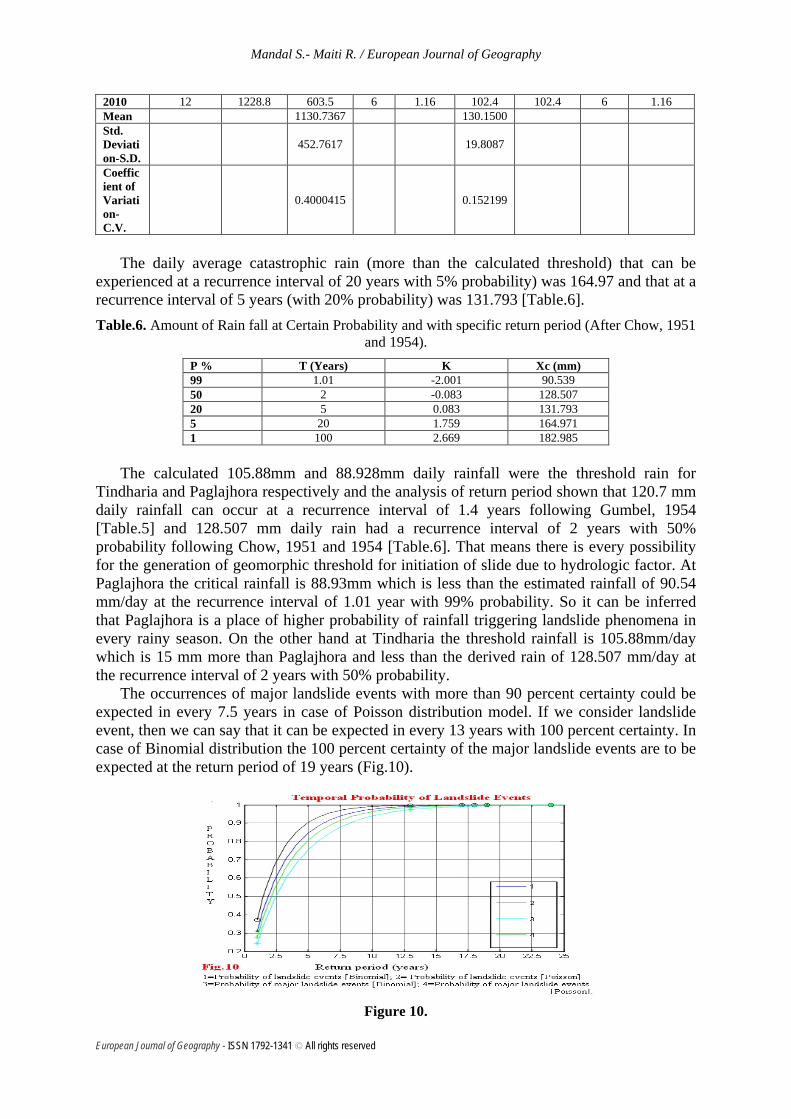
The daily average catastrophic rain (more than the calculated threshold) that can be
experienced at a recurrence interval of 20 years with 5% probability) was 164.97 and that at a recurrence interval of 5 years (with 20% probability) was 131.793 [Table.6]. Table.6. Amount of Rain fall at Certain Probability and with specific return period (After Chow, 1951
and 1954). P % T (Years) K Xc (mm) 99 1.01 -2.001 90.539 50 2 -0.083 128.507 20 5 0.083 131.793 5 20 1.759 164.971 1 100 2.669 182.985
The calculated 105.88mm and 88.928mm daily rainfall were the threshold rain for
Tindharia and Paglajhora respectively and the analysis of return period shown that 120.7 mm daily rainfall can occur at a recurrence interval of 1.4 years following Gumbel, 1954 [Table.5] and 128.507 mm daily rain had a recurrence interval of 2 years with 50% probability following Chow, 1951 and 1954 [Table.6]. That means there is every possibility for the generation of geomorphic threshold for initiation of slide due to hydrologic factor. At Paglajhora the critical rainfall is 88.93mm which is less than the estimated rainfall of 90.54 mm/day at the recurrence interval of 1.01 year with 99% probability. So it can be inferred that Paglajhora is a place of higher probability of rainfall triggering landslide phenomena in every rainy season. On the other hand at Tindharia the threshold rainfall is 105.88mm/day which is 15 mm more than Paglajhora and less than the derived rain of 128.507 mm/day at the recurrence interval of 2 years with 50% probability.
The occurrences of major landslide events with more than 90 percent certainty could be expected in every 7.5 years in case of Poisson distribution model. If we consider landslide event, then we can say that it can be expected in every 13 years with 100 percent certainty. In case of Binomial distribution the 100 percent certainty of the major landslide events are to be expected at the return period of 19 years (Fig.10).
Figure 10.
European Journal of Geography - ISSN 1792-1341 © All rights reserved

Mandal S.- Maiti R. / European Journal of Geography
4. CONCLUSION
In the Shivkhola watershed, physical and anthropogenic processes are active on slope in an interactive combination. Construction of settlement, road and associated deforestation destabilize soil and slope. Slope is steepened, soil becomes loose and friable, lateral support is removed, soil becomes saturated by hydrological intervention. All these together leads to instability and threshold condition are achieved. Ultimately slope failure occurs and that helps to achieve temporary stability.
The study was conducted to establish the role of rainfall, antecedent and critical rainfall that can generate geomorphic threshold and introduce slope failure. The intensive field investigation depicts that the rainfall in connection to the weak lithological composition [Gneiss, mica-schist & granulitic rocks, Mylonitised granite with sub-parallel thrust, Phyllite, silvery-mica-chlorite-schist, grey sericite, and Slate phyllite with quartzite, quartz-schist & greywake schist] permits easy saturation and reduces cohesion of the slope soil and initiate down slope movement at most of the places in the Shivkhola watershed. The study area receives the orographic rainfall and all the landslides are triggered by few days and one or two day’s continuous and heavy showers. Such rain introduces the geomorphic threshold by increasing pore-water pressure and reducing the cohesion and angle of internal friction. The determined critical rainfall at Paglajhora and Tindharia called for a warning system that can be used to warn the people or to rehabilitate the people living in the hazardous areas. Study concludes that there is a greater probability of frequent occurrence of debris slide which will reduce the slope angle on landslide scar face to that of repose angle to attain temporary stability through internal feed back in a process of homeostatic adjustment.
REFERENCES
Aleotti, P. 2004. A warning system of rainfall-induced shallow failure. Engineering Geology 73, 247–265.
Alford, D. 1992. Hydrological aspects of the Himalayan region. Occasional Paper No. 18. ICIMOD Kathmandu, 68 pp.
Bloom, A. L. 1991. Geomorphology, a systematic analysis of the Cenozoic Landforms, New Delhi, Prentice Hall of India Pvt. Ltd. (pp. 76-177).
Borga et al. 1998. Shallow Landslide hazard assessment using a physically based model and digital elevation data. Journal of Environmental Geology, 35(2-30): 81-88.
Brunsden, D., Jones, D.K.C., Martin, R.P., Doornkamp, J.C. 1981. The geomorphological character of part of the Low Himalaya of Eastern Nepal. Z. Geomorph. N.F. Suppl.-Bd. 37, 25–72.
Caine, N. 1980. The rainfall intensity–duration control of shallow landslides and debris flows. Geografiska Annaler 62A, 23–27.
Caine, N., Mool, P.K. 1982. Landslides in the Kolpu Khola Drainage, Middle Mountain, Nepal. Mountain Research and Development 2, 157–173.
Campbell, R.H. 1975. Soil slips, debris flows, and rainstorms in the Santa Monica Mountains and vicinity, Southern California. US Geol. Surv. Prof. Paper, vol. 851, pp. 1–20.
Cannon, S.H., Ellen, S.D. 1985. Rainfall conditions for abundant debris avalanches, San Francisco Bay region, California. Geology 38 (12), 267–272.
Cannon, S.H. 1988. Regional rainfall-threshold conditions for abundant debris-flow activity. In: Ellen, S.D., Wieczorek, G.F. (Eds.), Landslides, floods, and marine effects of the
European Journal of Geography - ISSN 1792-1341 © All rights reserved
Mandal S.- Maiti R. / European Journal of Geography
storm of January 3–5, 1982, in the San Francisco Bay Region, California. US Geol. Surv. Prof. Paper, vol. 1434, pp. 27–34.
Cardinali, M., Galli, M., Guzzetti, F., Ardizzone, F., Reichenbach, P., Bartoccini, P. 2006. Rainfall induced landslides in December 2004 in Southwestern Umbria, Central Italy. Nat. Hazards Earth Syst. Sci. 6, 237–260.
Carson, M.A. 1977. Application of the concepts of Threshold slopes to the Laramie Mountains, Wyoming, Inst. Br. Geogr. Spec. Publ. 3, 31-48.
Carson, M.A. 1977. Threshold and characteristic angles of straight slopes, proceedings of the 4th Guelph Symposium on Geomorphology, Norwich Geo Books, 19-34.
Carson, M.A. 1977. Angle of repose, angles of shearing resistance at angle of talus slopes, Earth Surface Processes (2), 263-380.
Ceriani, M., Lauzi, S., Padovan, N. 1992. Rainfall and landslides in the Alpine area of Lombardia Region, central Alps, Italy. In: Interpraevent Int. Symp, Bern, vol. 2, pp. 9–20.
Cotecchia, V. 1978. Systematic reconnaissance mapping and registration of slope movements. Bull. Int. Ass. Eng. Geol. 17, 5–37.
Crosta, G. 1998. Regionalization of rainfall threshold: an aid to landslide hazard evaluation. Environmental Geology 35 (2-3), 131–145.
Crosta, G., Frattini, P. 2001. Rainfall thresholds for triggering soil slips and debris flow. Proc.of EGS 2nd Plinius Conference 2000, Mediterranean Storms, Siena, pp. 463–488.
Crozier, M.J. 1997. The climate-landslide couple: a southern hemisphere perspective. In: Matthews, J.A., Brunsden, D., Frenzel, B., Glaeser, B., Weiss, M.M. (Eds.), Rapid mass movement as a source of climatic evidence for the Holocene. Gustav Fischer Verlag, Stuttgart, pp. 333–354.
Crozier, M. J. 1999. Prediction of rainfall-triggered landslides: a test of the antecedent water status model. Earth Surface Processes and Landforms 24, 825–833.
Culmann, C. 1866. Graphische Statik, Zurich.
Dahal, R.K. 1997. Engineering and environmental geological study of Kharidhunga–Tokarpa– Balephi area in the Lesser Himalaya, Central Nepal, M.Sc. Dissertation, Central Department of Geology, Tribhuvan University, Nepal, unpublished, 120 pp.
Dahal, R.K., Hasegawa, S., Masuda, T., Yamanaka, M. 2006a. Roadside slope failures in Nepal during torrential rainfall and their mitigation, In: Marui, H., Marutani, T., Watanabe, N., Kawabe, H., Gonda, Y., Kimura, M., Ochiai, H., Ogawa, K., Fiebiger, G., Heumader, J., Rudolf-Miklau, F., Kienholz, H. and Mikos, M. (Eds.), Proc. Interpraevent Int. Symp, Niigata 2006, Disaster mitigation of debris flow, slope failures and landslides, Universal Academy Press, Tokyo, vol. 2, pp. 503–514.
Dahal, R.K., Hasegawa, S., Yamanaka, M., Nishino K. 2006b. Rainfall triggered flow-like landslides: Understanding from southern hills of Kathmandu, Nepal and northern Shikoku, Japan. Proc 10th Int Congr of IAEG, The Geological Society of London, IAEG2006 Paper number 819 :1–14 (CD-ROM).
Dahal, R.K. 2006c. Geology for Technical Students - A textbook for Bachelor Level Students, Brikuti Academic Publication, Exhibition Road, Kathmandu, Nepal, 756 pp.
European Journal of Geography - ISSN 1792-1341 © All rights reserved
Mandal S.- Maiti R. / European Journal of Geography
De Vleeschauwer, C. &. De Smedt, F. 2002. Modeling slope stability using GIS on a regional scale, Proceedings of the first Geological Belgica International Meeting, Leuven, 11-15 September 2002. Aardkundige Mededelingen, 12: 253-256.
De Smedt, F. 2005. Slope Instability analysis using GIS on a regional scale: a case study of Narayanghat-Mungling highway section, Nepal, a dissertation report presented at Universiteit Gent, Vrije Universiteit Brusssel, Belgium.
Dhakal, A.S., Amada, T.K., Aniya M. 1999. Landslide hazard mapping and application of GIS in the Kulekhani Watershed, Nepal, Mountain Research and Development 19(1), 3–16.
Dhital, M.R., Khanal, N., Thapa, K.B. 1993. The role of extreme weather events, mass movements, and land use changes in increasing natural hazards, A Report of the preliminary field assessment and workshop on causes of recent damage incurred in southcentral Nepal, July 19-20 1993. ICIMOD, Kathmandu, 123 pp.
Dhital, M. R. 2003. Causes and consequences of the 1993 debris flows and landslides in the Kulekhani watershed, central Nepal. In: Rickenmann, D., Chen, C.-L. (Eds.), Proc. 3rd Intl. conf. debris-flow hazards mitigation: mechanics, prediction and assessment, Millpress, Rotterdam, Netherlands, vol. 2, pp. 931–942.
Fenti, V. 1992. Indagini geologic-techniche sull’ area del dispositivo di misura (in Italian) in Marchi L. (ed) II Basino attrezzato del Rio Cordon, Quadevni di Ricerca, n. 13, Ragione Veneto. Dipartimento Foreste, Venezia Mestre: (pp. 109-122).
Froehlich, W. Gil, E., Kasza I., Starkel, L. 1990).Thresholds in the transformation of slopes and river channels in the Darjeeling Himalaya, India. Mountain Research and Development 10(4), 301–312.
Froehlich, W., Starkel, L. 1993. The effects of deforestation on slope and channel evolution in the tectonically active Darjeeling Himalaya. Earth Surface Processes and Landforms 18(3), 285–290.
Gabet, E.J., Burbank, D.W., Putkonen, J.K., Pratt-Sitaula, B.A., Oiha, T. 2004. Rainfall thresholds for landsliding in the Himalayas of Nepal. Geomorphology 63, 131–143.
Gerrard, J., Gardner, R.A.M. 2000. Relationships between rainfall and landsliding in the Middle Hills, Nepal. Norsk geogr. Tidsskr. 54, 74–81.
Giannecchini, R. 2006. Relationship between rainfall and shallow landslides in the southern Apuan Alps (Italy). Nat. Hazards Earth Syst. Sci. 6, 357–364.
Glade, T 1998. Establishing the frequency and magnitude of landslide-triggering rainstorm events in New Zealand, Environmental Geology, 35, 160-174.
Glade, T., Crozier, M., Smith, P. 2000. Applying probability determination to refine landslidetriggering rainfall thresholds using an empirical Antecedent Daily Rainfall Model. Pure and Applied Geophysics 157, 1059–1079.
Guzzetti, F., Cardinali, M., Reichenbach, P., Cipolla, F., Sebastiani, C., Galli, M., Salvati, P. 2004. Landslides triggered by the 23 November 2000 rainfall event in the Imperia Province, Western Liguria, Italy. Engineering Geology 73, 229–245.
Guzzetti, F., Peruccacci, S., Rossi, M., Stark, C.P. 2007. Rainfall thresholds for the initiation of landslides in central and southern Europe. Meteorol. Atmos. Phys., online first version, DOI 10.1007/s00703-007-0262-7 (accessed on 2007–08–07).
Innes, J.L. 1983 Debris flows. Prog Phys Geog 7, 469–501.
European Journal of Geography - ISSN 1792-1341 © All rights reserved
Mandal S.- Maiti R. / European Journal of Geography
Jibson, R.W. 1989 Debris Flow in Southern Porto Rico. In: Schultz, A.P., Jibson, R.W. (Eds.), Landslide processes of the Eastern United States and Puerto Rico. Geological Society of America Special Paper, vol. 236, pp. 29–55.
JICA, 1993 Report of Japan Disaster Relief Team (Expert Team) on heavy rainfall and floods in Nepal. Japan International Cooperation Agency (JICA), JR1JDC/93-03, unpublished, 125pp.
Keefer, D.K., Wilson, R.C., Mark, R.K., Brabb, E.E., Brown, W.M., Ellen, S.D., Harp, E.L., Wieczorek, G.F., Alger, C.S., Zatkin, R.S. 1987 Real-time warning during heavy rainfall. Science 238(4829), 921–925.
Khanal, N.R., Watanabe, T. 2005 Landslide and debris flow hazards induced by heavy precipitation in Nepal. Proc. Intl. symposium on landslide hazard in orogenic zone from the Himalaya to Island Arc in Asia, pp. 111–118.
Khanal, R.K. 1991 Historic landslides of Nepal during 1902-1990 A.D., extent and economic significance. M.Sc. Dissertation, Central Department of Geology, Tribhuvan University, Nepal, unpublished, 94 pp.
Kim, S.K., Hong, W.P., Kim, Y.M. 1991 Prediction of rainfall triggered landslides in Korea. In: Bell, D.H. (Ed.), Landslides, Rotterdam: A.A. Balkema, vol. 2, pp. 989–994.
Larsen, M.C., Simon, A. 1993 A rainfall intensity-duration threshold for landslides in a humid tropical environment, Puerto Rico. Geografiska Annaler 75(1–2), 13–23.
Li, T. 1990. Landslide management in the mountain area of China. ICIMOD Kathmandu, Occasion Paper No. 15, 50 pp.
Li, T., Wang, S. 1992. Landslide hazards and their mitigation in China, Science Press, Beijing, 84 pp.
Maiti, R. 2007. Identification of Potential Slope Failure Zones of Shiv-Khola Watershed; Darjiling Himalaya, Through Critical Analysis of Slope Instability- A Step towards Rational and Scientific Management of Land, Soil and Water, UGC Sponsored Minor Research Project [F.31-210/2005(31.03.2007)]
Manandhar, I.N., Khanal, N.R. 1988. Study on landscape process with special reference to landslides in Lele watershed, central Nepal. Report submitted to Research Division, Tribhuvan University, unpublished, 53 pp.
Manandhar, S. 2000. Engineering geological studies of the landslides in the Kulekhani catchment. central Nepal, Lesser Himalaya, M.Sc. Dissertation, Central Department of Geology, Tribhuvan University, Nepal, unpublished, 130 pp.
Metteotti, G. 1996. Valutazione del rischio di franosita per unbacino di tipo alpino (in Italian), Ph. D. Dissertation, University of Padova, Italy.
Melnikov, M. and Chensokov, M. 1969. Safety in open cast minning, Moscow: Mir Publications.
MoHA, (2004) Disaster scenario of Nepal (2000–2003). Ministry of Home Affair, Government of Nepal, 157 pp.
Montgomery, D.R., Dietrich, W.E. 1994. A physically based model for the topographic control on shallow landsliding. Water Resources Research 30 (4), 1153–1171.
Neary, D.G., Swift, Jr., L.W. 1987. Rainfall thresholds for triggering a debris avalanching event in the southern Appalachian Mountains. In: Costa, J.E., Wieczorek, G.F. (Eds.),
European Journal of Geography - ISSN 1792-1341 © All rights reserved
Mandal S.- Maiti R. / European Journal of Geography
Debris flows/avalanches: process, recognition and mitigation. Geological Society of America, Reviews in Engineering Geology 7, 81–92.
Pethick, J. 1984. An introduction to Coastal Geomorphology, (pp. 73-74) Arnold Pub. London.
Polloni, G., Ceriani, M., Lauzi, S., Padovan, N., Crosta, G. 1992. Rainfall and soil slipping events in Valtellina. Proc. of the VI International Symposium on Landslides, Christchurch, vol. 1, pp.183–188.
Polloni, G., Aleotti, P., Baldelli, P., Nosetto, A., Casavecchia, K. 1996. Heavy rain triggered landslides in the Alba area during November 1994 flooding event in the Piemonte Region (Italy). Proc. VII International Symposium on Landslides, Trondheim, vol. 3, pp. 1955–1960.
Pomeroy, J.S. 1984. Storm-induced slope movements at East Brady, northwestern Pennsylvania. US Geological Survey Bull, vol. 1618, 16 pp.
Schumm, S.A. 1977. The Fluvial System, John Willy and Sons, New York.
Schumm, S.A. 1977. Drainage Basin Morphology, Bechmark Papers in Geology, 4, Hutchinsons and Ross, Pennsylvannia: Dowden.
Schwab et al. 2002. Soil and water conservation Engineering (pp.18-47) John Wiley and Sons, Inc. New York.
Skempton, A.W. and Hutchinson, J.N. 1969. Stability of natural slope and embankment section, Proceedings 7th Int. Cong. Soil. Mech. Eng. Mexicom, 291-340.
Starkel, L. 1972. The role of catastrophic rainfall in the shaping of the relief of the Lower Himalaya (Darjeeling Hills). Geogr. Polonica 21, 103–147.
Terlien, M.T.J. 1997. Hydrological landslide triggering in ash covered slopes of Manizales (Columbia). Geomorphology 20, 165–175.
Terlien, M.T.J. 1998. The determination of statistical and deterministic hydrological landslide triggering thresholds. Environmental Geology 35 (2-3), 124–130.
Terzaghi, K. 1962. Stability of steep slopes on Hard Unweathered Rock, Geothnique, 12, 251-270.
Upreti, B.N. 1999. An overview of the stratigraphy and tectonics of the Nepal Himalaya. Journal of Asian Earth Sciences 17, 577–606.
Upreti, B.N., Dhital, M.R. 1996. Landslide studies and management in Nepal. ICIMOD, Nepal, 87 pp.
Van Burkalow, A. 1945. Angle of repose and angle of sliding friction; An Experimental study, Geol. Soc. America. Bull. 56, 669-707.
Varnes, D.J. 1978. Slope movement types and process. In Schuster R.L., Krizek, R.J. (Eds.), Landslides Analysis and Control. Special Report 176, Transportation Research Board, National Academy of Sciences, Washington D.C, pp.12–33.
White, I.D., Mottershead, D.N., Harrison J.J. 1996. Environmental systems, 2nd ed. London, Chapman and Hall, 616 pp.
Wieczorek, G.F. 1987. Effect of rainfall intensity and duration on debris flows in central Santa Cruz Mountains, California. In: Crosta, G., Wieczorek G.F. (Eds.), Debris flows/
European Journal of Geography - ISSN 1792-1341 © All rights reserved
Mandal S.- Maiti R. / European Journal of Geography
avalanches: processes, recognition and mitigation. Reviews in Engineering Geology, vol. 7. Geological Society of America, pp. 23–104.
Wieczorek, G.F. 1996. Landslide triggering mechanisms. In: Turner, A.K., Schuster, R.L. (Eds.), Landslides: Investigation and Mitigation, Transportation Research Board, Special Report 247. National Research Council, Washington, pp. 76–79.
Wieczorek, G.F., Morgan, B.A., Campbell, R.H. 2000. Debris flow hazards in the Blue Ridge of Central Virginia. Environmental and Engineering Geoscience 6 (1), 3–23.
Wilson, R.C., Torikai, J.D., Ellen, S.D. 1992. Development of rainfall warning thresholds for debris flows in the Honolulu District, Oahu. USGS Open-File, vol. 92–521, 45 pp.
Wilson, R.C., Wieczorek, G.F. 1995. Rainfall threshold for the initiation of debris flow at La Honda, California. Environmental and Engineering Geoscience 1(1), 11–27.
Wilson, R.C. 1997. Normalizing rainfall/debris-flow thresholds along the U.S. Pacific coast for long-term variations in precipitation climate. In: Chen, C.L., (Ed.), Proc. 1st Int. Conf. on Debris-Flow Hazard Mitigation, San Francisco, American Society of Civil Engineers, pp.32–43.
Zezere J.L., Trigo R.M., Trigo I.F. 2005. Shallow and deep landslides induced by rainfall in the Lisbon region (Portugal): assessment of relationships with the North Atlantic Oscillation. Nat. Hazards Earth Sys. Sc
European Journal of Geography - ISSN 1792-1341 © All rights reserved