ASSESSING LANDSCAPE RESTORATION OPPORTUNITIES FOR ... · It gives me great pleasure in introducing...
108
INTERNATIONAL UNION FOR CONSERVATION OF NATURE ASSESSING LANDSCAPE RESTORATION OPPORTUNITIES FOR UTTARAKHAND, INDIA JUNE 2018
Transcript of ASSESSING LANDSCAPE RESTORATION OPPORTUNITIES FOR ... · It gives me great pleasure in introducing...
INTERNATIONAL UNION FOR CONSERVATION OF NATURE
ASSESSING LANDSCAPE RESTORATION OPPORTUNITIES FOR UTTARAKHAND, INDIA
JUNE 2018

ASSESSING LANDSCAPE RESTORATION OPPORTUNITIES FOR UTTARAKHAND, INDIA
JUNE 2018
The designation of geographical entities in this book, and the presentation of the material, do not
imply the expression of any opinion whatsoever on the part of IUCN concerning the legal status
of any country, territory, or area, or of its authorities, or concerning the delimitation of its
frontiers or boundaries.
The views expressed in this publication do not necessarily reflect those of IUCN and G.B. Pant
National Institute of Himalayan Environment & Sustainable Development (GBPNIHESD).
This publication has been made possible by funding from the Federal Ministry for the
Environment, Nature Conservation and Nuclear Safety, based on a decision of the German
Bundestag.
IUCN India in collaboration with GBPNIHESD
© 2018 IUCN, International Union for Conservation of Nature and Natural
Resources, and G.B. Pant National Institute of Himalayan Environment &
Sustainable Development (GBPNIHESD)
Reproduction of this publication for educational or other non-commercial
purposes is authorised without prior written permission from the copyright
holder, provided the source is fully acknowledged.
Reproduction of this publication for resale or other commercial purposes is
prohibited without prior written permission of the copyright holder.
GBPNIHESD: R.S. Rawal, G.C.S.Negi, S. Sharma, R. Joshi and D.S. Rawat
IUCN India: A. Bhattacharjee, N.M. Ishwar, J.S. Rawat and P.R. Sinha
Bhattacharjee, A., Rawal, R.S., Negi, G.C.S., Joshi, R., Sharma, S., Rawat, D.S.,
Ishwar, N.M., Rawat, J.S., Sinha, P.R., Jia, L., and Merten, J. (2018). Assessing
Landscape Restoration Opportunities for Uttarakhand, India. New Delhi, India: IUCN.
xiii+85 pp. *
© Anushree Bhattacharjee
Kavita Sharma
Bright Services
IUCN (International Union for Conservation of Nature)
C-10, Gulmohar Park,
New Delhi 110049, India
Telefax - +91 11 2652 7742
Published by:
Copyright:
Project team:
Citation:
Cover photo:
Copyedited by:
Designed & Printed by:
Available from:
www.iucn.org/resources/publications
* This publication is based on the Project Technical Report submitted by GBPNIHESD, titled Utilizing Landscape-scale
Ecosystem Rehabilitation as a Cost Effective Bridge for the Integrated Deployment of National Land-based Mitigation and
Adaptation Strategies - case study in Uttarakhand, India. For more information, please send a mail to IUCN:
and GBPNIHESD: [email protected] [email protected].
Acknowledgements
We are deeply grateful for the enthusiastic cooperation we received from the numerous people
who were part of the assessment. It is impossible for us to name each one of them but their
important contributions are graciously acknowledged. The authors of this report also extend a
note of thanks to IUCN's Global Forest and Climate Change Programme (GFCCP) and Director,
GBPNIHESD, who helped drive the entire process. Thanks are also due to the various line
departments in the Government of Uttarakhand, as well as in the districts of Pithoragarh and
Garhwal, for providing critical inputs on the findings of the assessment and helping us arrive at
important insights. Finally, we are grateful to the Ministry of Environment, Forest and Climate
Change for their guidance and support through the process.
List of tables……………………………………………………………………………………..... i
List of figures……………………………………………………………………………………... ii
List of boxes……………………………………………………………………………………..... iii
List of appendices………………………………………………………………………………... iii
List of abbreviations……………………………………………………………………………... iv
Foreword, Director General of Forests and Special Secretary,
Ministry of Environment, Forest and Climate Change …………………………………….…. vi
Foreword, Principal Chief Conservator of Forests and
Head of Forest Force, Uttarakhand…………………………………………………………….. vii
Executive summary……………………………………………………………………………... viii
1. Introduction………………………………………………………………………………….… 1
1.1 Location and context of ROAM in Uttarakhand……...…………………………..... 2
1.2 Objectives of the study……………………………………………………………..... 5
2. Methodology…………………………………………………………………………………... 6
2.1 ROAM process……………………………………………………………………...... 6
2.2 Stratification of the landscape………………………………………………………. 7
2.3 Multi-criteria spatial analysis……………………………………………………….. 7
2.4 Stakeholder consultations…………………………………………………………... 8
3. Landscape challenges…………………………………………………………………………. 11
3.1 Summary of stakeholder consultations……………………………………….……. 11
3.2 Summary of degradation drivers facing Uttarakhand.…………………………… 12
TABLE OF CONTENTS
4. Overview of restoration efforts in Uttarakhand…………………………………………….. 18
5. Multi-criteria spatial analysis………………………………………………………………… 23
5.1 Functional degradation map...………………………………………………............ 23
5.2 FLR priority map……………………………………………………………………... 32
6. Restoration strategy - Priorities and interventions by strata ………………………………. 38
6.1 High altitude (2,000–3,000 m asl)..………………………………….………………. 38
6.2 Mid altitude (1,000–2,000 m asl)...…………………………………………………... 43
6.3 Low altitude (< 1,000 m asl)………………………………………………………….. 49
6.4 Crosscutting interventions………………………………………………………….. 51
7. Opportunities and roadmap for the future………..…………………………………………. 54
Bibliography…………………………………………………………………………………....... 58
Appendices…………………………………………………………………….………………… 64
Table 2.2: Summary of stakeholder consultations in Uttarakhand
Table 3.1: Forest fire incidents and reported loss in Uttarakhand
Table 4.1: Summary of major restoration programmes undertaken in Uttarakhand
Table 4.2: Summary of major restoration programmes undertaken in Pithoragarh district
Table 4.3: Summary of major restoration programmes undertaken in Garhwal district
Table 5.1: Summary of data used and assumptions for developing the functional degradation
map
Table 5.2: Functional degradation areas in different strata of Uttarakhand
Table 5.3: Summary of parameters used for developing multi-criteria FLR priority mapping
Table 5.4: Forest landscape restoration priority areas in different strata of Uttarakhand
Table 6.1: Benefit-cost ratio of important medicinal and aromatic plants in Uttarakhand
Table 6.2: Change in water availability in Gorang valley (Pithoragarh) after implementation
of springshed management
Table 6.3: Benefit-cost ratio of important vegetable crops
Table 6.4: Common multi-purpose tree species and their multiple uses
LIST OF TABLES
Figure 1.1: Location map of Uttarakhand, with the two intensive sample sites (Pithoragarh
and Garhwal districts) highlighted
Figure 2.1: Process framework for ROAM
Figure 2.2: Flow chart of the multi-criteria spatial analysis process
Figure 3.1: Fodder collection and fuelwood storage by households
Figure 5.1: Rural population density of Uttarakhand in 2011
Figure 5.2: Change in rural population density (2001–2011) in Uttarakhand
Figure 5.3: Families below the poverty line in Uttarakhand
Figure 5.4: Firewood usage in Uttarakhand
Figure 5.5: Forest fire incidences (including buffer) in Uttarakhand (2013–2016)
Figure 5.6: Soil depth levels in Uttarakhand
Figure 5.7: Soil erosion intensity in Uttarakhand
Figure 5.8: Wastelands and areas under diminishing natural productivity in Uttarakhand
Figure 5.9: Forest density in Uttarakhand
Figure 5.10: Forest types in Uttarakhand
Figure 5.11: Functional degradation map of Uttarakhand
Figure 5.12: Land use/land cover map of Uttarakhand (2015)
Figure 5.13: LPG usage in Uttarakhand
Figure 5.14: Elevation zones in Uttarakhand
Figure 5.15: Slope levels of Uttarakhand
Figure 5.16: Aspect map of Uttarakhand
Figure 5.17: Forest landscape restoration priority map of Uttarakhand
LIST OF FIGURES
ii
Box 6.1: Stabilisation of slope instabilities and landslides through mountain risk engineering
Box 6.2: Maati – A model for promoting alternative livelihoods in rural Uttarakhand
Box 6.3: Role of community and mobile phone applications to analyse degradation due to
forest fires
Box 6.4. Efforts to use chir pine needles by a regional NGO – Avani case study
Box 6.5: Springshed management as an ecosystem service and restoration option
Box 6.6: Introducing bay leaf in degraded agroforestry systems
Box 6.7: Plantation of multi-purpose trees in degraded lands and agroforestry systems
LIST OF BOXES
iii
Appendix 1: Intensive sample sites – Pithoragarh and Garhwal
Appendix 2: List of block-level stakeholder consultations in Pithoragarh and Garhwal
Appendix 3: Restoration programmes in Uttarakhand
Appendix 4: Multi-criteria analysis for intensive sample sites
Appendix 5: Proceedings of the ROAM validation workshop in Uttarakhand
LIST OF APPENDICES
iv
BCR Benefit-cost ratio
CAMPA Compensatory Afforestation Fund Management and Planning Authority
CAP Centre for Aromatic Plants
CBO Community-based organisation
CSR Corporate social responsibility
DMMC Disaster Mitigation and Management Centre
EEC European Economic Community
FLR Forest landscape restoration
GBPNIHESD G.B. Pant National Institute of Himalayan Environment & Sustainable
Development
GCF Green Climate Fund
GEF Global Environment Facility
GFCCP Global Forest and Climate Change Programme
GIM National Mission for a Green India
GIS Geographic information system
ICIMOD International Centre for Integrated Mountain Development
IFAD International Fund for Agricultural Development
IHR Indian Himalayan Region
ILSP Integrated Livelihood Support Project
IUCN International Union for Conservation of Nature
JICA Japan International Cooperation Agency
LPG Liquefied petroleum gas
LIST OF ABBREVIATIONS
v
MAP Medicinal and aromatic plants
MGNREGA Mahatma Gandhi National Rural Employment Guarantee Act
MoEFCC Ministry of Environment, Forest and Climate Change
MPT Multi-purpose tree
MRE Mountain risk engineering
MWS Micro-watershed
NABARD National Bank for Agriculture and Rural Development
NAP National Afforestation Programme
NBT National Biodiversity Target
NDC Nationally Determined Contribution
NTFP Non-timber forest product
ROAM Restoration Opportunities Assessment Methodology
SAPCC State Action Plan on Climate Change
SBB State Biodiversity Board
SCCC State Climate Change Centre
SDG Sustainable Development Goal
SHG Self-help group
SMPB State Medicinal Plants Board
SWEET Sloping Watershed Environmental Engineering Technology
UNDP United Nations Development Programme
UNFCCC UN Framework Convention on Climate Change
WMD Watershed Management Directorate
WRI World Resources Institute
vi
India’s national policies have always had a strong focus on environment, nature and wildlife. Since the
1952 National Forest Policy (NFP), there has been a strong advocacy to have minimum of one-third of the
total land area of the country under forest or tree cover, while maintaining two-third of the area under
green cover in mountainous and hilly regions. As per the latest FSI report, present forest and tree cover is
24.39% of the country’s geographical area. Therefore, to bring a minimum of one-third of the total land
area of the country under forest and tree cover, an additional 27.8 million hectares of land area would need
to be brought under green cover. This means that we need to start looking beyond designated forest lands
and business as usual scenarios.
Recognizing the multiple benefits of restoration, Government of India announced its support for the Bonn
Challenge initiative in 2015, with a 21 million hectare restoration pledge, becoming one of the first
countries in Asia to join the global target of landscape restoration. IUCN has been working with the
Ministry in operationalizing this pledge and documenting the progress being made.According to a recent
joint publication of IUCN and MoEFCC, India is appropriately positioned to meet its restoration
commitments under the Bonn Challenge pledge, with 9.8 million hectares already brought under
restoration till 2017. Aspirations under Bonn Challenge would be achievable only when we align it with
people’s aspirations and develop economically viable and socially acceptable strategies.
It gives me great pleasure in introducing the report “Assessing Landscape Restoration Opportunities for
Uttarakhand, India”. The study was carried out by IUCN in partnership with the G.B. Pant National
Institute of Himalayan Environment & Sustainable Development (GBPNIHESD), in consultation with the
Government of Uttarakhand. The report presents a forest landscape restoration priority map for the state
of Uttarakhand along with restoration strategies for different elevation zones. I hope this study can be
translated into action on the ground in the future in the state of Uttarakhand, while providing lessons for
other states to also embark on such analysis.
I congratulate all those who were involved, directly and indirectly, in the preparation of the report.
Mr. Siddhanta Das Director General of Forests and Special Secretary
Ministry of Environment, Forestand Climate ChangeGovernment of IndiaNew Delhi - 110 003
June 25, 2018
(Siddhanta Das)
FOREWORD
vii
th th Uttarakhand is a relatively new state formed on 9 November 2000 as the 27 state of India. With over 45%
of the total geographical area under forests as per the latest Forest Survey of India report, Uttarakhand is
primarily a forested landscape. However, Uttarakhand is also susceptible to natural calamities such as
earthquakes, landslides, fires, floods, cloudbursts and flash floods. As per the recent Forest Survey of
India report, although the state has recorded a net increase in green cover of 23 sq km (mainly attributed to
expansion of tree cover outside forests), there has been a net decrease of 49 sq km in forest cover with
Recorded Forest Area due to rotational felling and developmental activities.
The state of Uttarakhand has a rich history of community forest management as it was one of the pioneer
states for the Joint Forest Management system that was introduced in various states by the Government of
India. The state is also well known for the presence of unique medicinal and aromatic plants (MAPs). The
value of biodiversity for sustaining and nourishing human communities is immense. To take an example,
the ecosystem services from the forested watersheds of the Himalayas indirectly support several million
people in India. Thus, the potential for forest landscape restoration (FLR) approach in India is immense. It
is not possible to have a comprehensive restoration plan unless one knows where and how to restore. The
immediate need is to identify opportunities for landscape restoration in a scientific manner and suggest
applicable interventions to restore ecological functions of degraded landscapes, while ensuring flow of
multiple benefits.
I am happy to present this report which is a sub-national ROAM piloted in the state of Uttarakhand, by
IUCN with G.B. Pant National Institute of Himalayan Environment & Sustainable Development
(GBPNIHESD). The Government of Uttarakhand was involved through all stages of the ROAM
assessment. It is encouraging that concerned departments, line agencies as well as local communities were
consulted and contributed to this study.
It is important to understand that this is a dynamic report. This means that there is potential for the FLR
priority map to evolve and adapt with changing priorities of the state.
I congratulate all those who were involved in the preparation of the report.
Mr. Jai RajPrincipal Chief Conservatorof Forests and Head of Forest Force
Forest DepartmentGovernment of Uttarakhand
Dehradun–248001June 25, 2018
(Jai Raj)
FOREWORD
India’s National Forest Policy advocates for bringing at least one-third of the country’s
geographical area under forest and tree cover. According to the latest report of the Forest Survey
of India, 2017, the total forest and tree cover of the country is 80.20 million hectares, that is, 24.39%
of the country’s geographical area, indicating need for greater expansion of the green cover.
India’s Nationally Determined Contribution (NDC) under the UN Framework Convention on
Climate Change (UNFCCC) includes the target of creating an additional carbon sink of 2.5–3
billion tonnes of CO equivalent through additional forest and tree cover by 2030. Another of 2
India’s important commitments is the Bonn Challenge. India joined the Bonn Challenge in 2015
and pledged to bring under restoration 13 million hectares of degraded land by 2020, and an
additional 8 million hectares by 2030. These targets, though ambitious, are achievable if the
drivers of forest landscape degradation are identified and appropriate interventions set in
motion. Forest landscape restoration (FLR), the ongoing process of regaining ecological
functionality and enhancing human well-being across deforested or degraded landscapes, is one
of the most practical ways of achieving these national targets and international commitments.
However, before FLR can be undertaken, it is important to first identify the potential sites that
need to be restored on a priority basis and the optimal restoration interventions that are suited to
a specific landscape. The Restoration Opportunities Assessment Methodology (ROAM),
developed by IUCN (International Union for Conservation of Nature) and the World Resources
Institute (WRI), is a robust framework to guide the processes for developing restoration
interventions at the landscape level. This report summarises the sub-national ROAM that was
piloted in the state of Uttarakhand, one among the 12 states that form the Indian Himalayan
Region (IHR). The pilot study was carried out by IUCN, with the G.B. Pant National Institute of
Himalayan Environment & Sustainable Development (GBPNIHESD) as the implementing
partner in the state. The Government of Uttarakhand was involved in all stages of the ROAM
assessment.
Uttarakhand has 45.43% of its geographical area under forest cover. A large proportion of the
human population is rural (69.77%). Since 11 districts in Uttarakhand are hill districts (covering
approximately 86% of the state), Uttarakhand is a good representative of Himalayan states.
Hence, the ROAM findings and recommendations from Uttarakhand could also be applicable to
other Himalayan states. While the ROAM assessment was carried out for the entire state of
EXECUTIVE SUMMARY
viii

ix
Uttarakhand, two of the state’s districts – Pithoragarh and Garhwal – were selected as intensive
sample sites for detailed stakeholder consultations, which were a key part of the assessment
exercise.
The landscape restoration interventions proposed in this report are intended to address the
specific needs that were identified by different stakeholders – relevant government departments
and line agencies, research institutions, NGOs/civil society organisations (CSOs), people’s
elected representatives, van panchayats (village forest councils) and local communities at state,
district and block levels. Stakeholder consultations identified specific interventions for
augmenting the health and productivity of degraded landscapes to improve the quality of life of
local dependent communities and enhancing the recharge of natural springs and other ecosystem
services. Restoration of degraded forest landscapes would also enhance the mitigation and
adaptation potential of the landscape and local communities to climate change.
The ROAM assessment identified the following as the major drivers of landscape degradation in
the state: forest fires, invasion by unwanted species (especially chir pine), free livestock grazing,
landslides, increasing anthropogenic pressure and growing community apathy towards
agriculture and forest management. The assessment also provided an overview of the major
restoration-related efforts undertaken by various agencies, both government and non-
government, in the state and in the two intensive sample sites.
Using multi-criteria spatial analysis, the assessment developed a functional degradation map for
the state of Uttarakhand; functional degradation refers to the deterioration in quality and
standard of performance of a functional unit or area due to degradation drivers.
Figure ES1:Functional degradation map of Uttarakhand
x
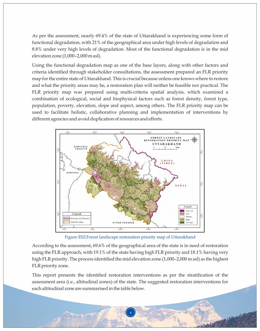
Figure ES2:Forest landscape restoration priority map of Uttarakhand
As per the assessment, nearly 69.4% of the state of Uttarakhand is experiencing some form of
functional degradation, with 21% of the geographical area under high levels of degradation and
8.8% under very high levels of degradation. Most of the functional degradation is in the mid
elevation zone (1,000–2,000 m asl).
Using the functional degradation map as one of the base layers, along with other factors and
criteria identified through stakeholder consultations, the assessment prepared an FLR priority
map for the entire state of Uttarakhand. This is crucial because unless one knows where to restore
and what the priority areas may be, a restoration plan will neither be feasible nor practical. The
FLR priority map was prepared using multi-criteria spatial analysis, which examined a
combination of ecological, social and biophysical factors such as forest density, forest type,
population, poverty, elevation, slope and aspect, among others. The FLR priority map can be
used to facilitate holistic, collaborative planning and implementation of interventions by
different agencies and avoid duplication of resources and efforts.
According to the assessment, 69.6% of the geographical area of the state is in need of restoration
using the FLR approach, with 19.1% of the state having high FLR priority and 18.1% having very
high FLR priority. The process identified the mid elevation zone (1,000–2,000 m asl) as the highest
FLR priority zone.
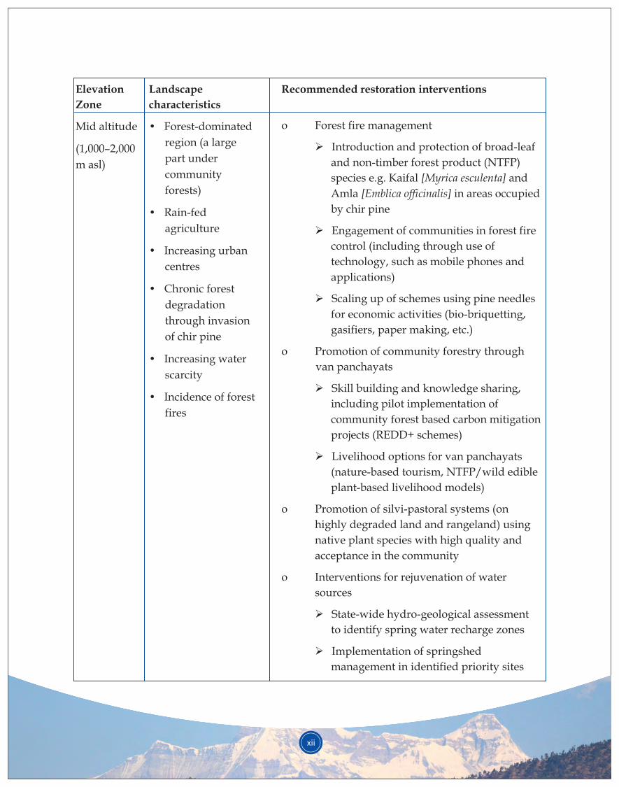
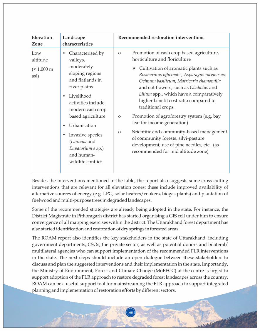
This report presents the identified restoration interventions as per the stratification of the
assessment area (i.e., altitudinal zones) of the state. The suggested restoration interventions for
each altitudinal zone are summarised in the table below.
xi
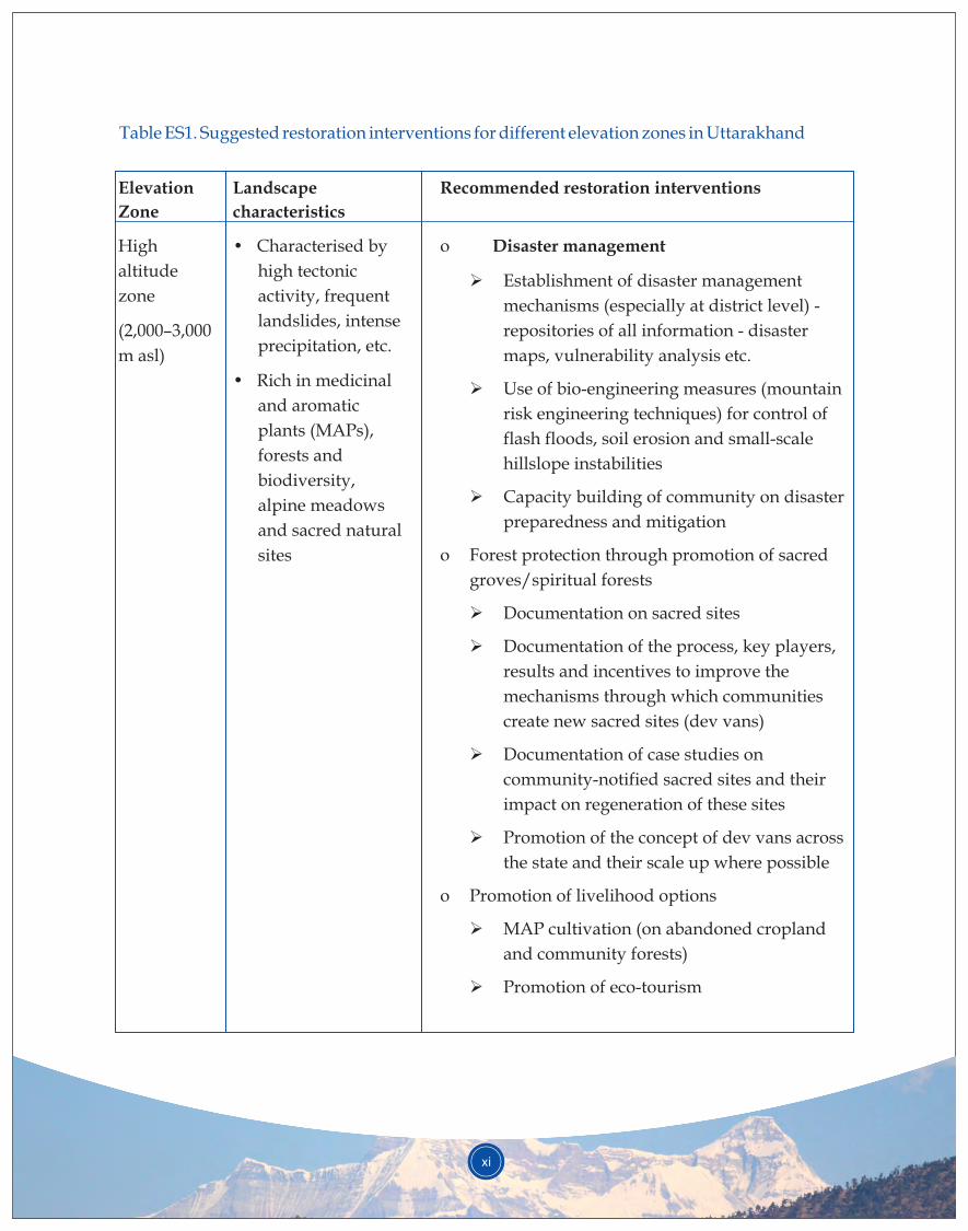
Table ES1. Suggested restoration interventions for different elevation zones in Uttarakhand
Elevation
Zone
High
altitude
zone
(2,000–3,000
m asl)
Landscape
characteristics
• Characterised by
high tectonic
activity, frequent
landslides, intense
precipitation, etc.
• Rich in medicinal
and aromatic
plants (MAPs),
forests and
biodiversity,
alpine meadows
and sacred natural
sites
Recommended restoration interventions
o Disaster management
Establishment of disaster management
mechanisms (especially at district level) -
repositories of all information - disaster
maps, vulnerability analysis etc.
Use of bio-engineering measures (mountain
risk engineering techniques) for control of
flash floods, soil erosion and small-scale
hillslope instabilities
Capacity building of community on disaster
preparedness and mitigation
o Forest protection through promotion of sacred
groves/spiritual forests
Documentation on sacred sites
Documentation of the process, key players,
results and incentives to improve the
mechanisms through which communities
create new sacred sites (dev vans)
Documentation of case studies on
community-notified sacred sites and their
impact on regeneration of these sites
Promotion of the concept of dev vans across
the state and their scale up where possible
o Promotion of livelihood options
MAP cultivation (on abandoned cropland
and community forests)
Promotion of eco-tourism
Ø
Ø
Ø
Ø
Ø
Ø
Ø
Ø
Ø
xii
Elevation
Zone
Mid altitude
(1,000–2,000
m asl)
Landscape
characteristics
•
region (a large
part under
community
forests)
• Rain-fed
agriculture
• Increasing urban
centres
• Chronic forest
degradation
through invasion
of chir pine
• Increasing water
scarcity
• Incidence of forest
fires
Forest-dominated
Recommended restoration interventions
o Forest fire management
Introduction and protection of broad-leaf
and non-timber forest product (NTFP)
species e.g. Kaifal [Myrica esculenta] and
Amla [Emblica officinalis] in areas occupied
by chir pine
Engagement of communities in forest fire
control (including through use of
technology, such as mobile phones and
applications)
Scaling up of schemes using pine needles
for economic activities (bio-briquetting,
gasifiers, paper making, etc.)
o Promotion of community forestry through
van panchayats
Skill building and knowledge sharing,
including pilot implementation of
community forest based carbon mitigation
projects (REDD+ schemes)
Livelihood options for van panchayats
(nature-based tourism, NTFP/wild edible
plant-based livelihood models)
o Promotion of silvi-pastoral systems (on
highly degraded land and rangeland) using
native plant species with high quality and
acceptance in the community
o Interventions for rejuvenation of water
sources
State-wide hydro-geological assessment
to identify spring water recharge zones
Implementation of springshed
management in identified priority sites
Ø
Ø
Ø
Ø
Ø
Ø
Ø
xiii
Elevation
Zone
Low
altitude
(< 1,000 m
asl)
Landscape
characteristics
•
valleys,
moderately
sloping regions
and flatlands in
river plains
• Livelihood
activities include
modern cash crop
based agriculture
• Urbanisation
• Invasive species
(Lantana and
Eupatorium spp.)
and human-
wildlife conflict
Characterised by
Recommended restoration interventions
o Promotion of cash crop based agriculture,
horticulture and floriculture
Cultivation of aromatic plants such as
Rosmarinus officinalis, Asparagus racemosus,
Ocimum basilicum, Matricaria chamomilla
and cut flowers, such as Gladiolus and
Lilium spp., which have a comparatively
higher benefit cost ratio compared to
traditional crops.
o Promotion of agroforestry system (e.g. bay
leaf for income generation)
o Scientific and community-based management
of community forests, silvi-pasture
development, use of pine needles, etc. (as
recommended for mid altitude zone)
Ø
Besides the interventions mentioned in the table, the report also suggests some cross-cutting
interventions that are relevant for all elevation zones; these include improved availability of
alternative sources of energy (e.g. LPG, solar heaters/cookers, biogas plants) and plantation of
fuelwood and multi-purpose trees in degraded landscapes.
Some of the recommended strategies are already being adopted in the state. For instance, the
District Magistrate in Pithoragarh district has started organising a GIS cell under him to ensure
convergence of all mapping exercises within the district. The Uttarakhand forest department has
also started identification and restoration of dry springs in forested areas.
The ROAM report also identifies the key stakeholders in the state of Uttarakhand, including
government departments, CSOs, the private sector, as well as potential donors and bilateral/
multilateral agencies who can support implementation of the recommended FLR interventions
in the state. The next steps should include an open dialogue between these stakeholders to
discuss and plan the suggested interventions and their implementation in the state. Importantly,
the Ministry of Environment, Forest and Climate Change (MoEFCC) at the centre is urged to
support adoption of the FLR approach to restore degraded forest landscapes across the country.
ROAM can be a useful support tool for mainstreaming the FLR approach to support integrated
planning and implementation of restoration efforts by different sectors.
Deforestation and land degradation pose a perilous threat to livelihoods, sustenance, and social and
economic well-being of millions around the world. Urgent attention must be directed toward forest
landscape restoration (FLR), the ongoing process of regaining ecological functionality and enhancing
human well-being across deforested or degraded forest landscapes. FLR is more than just planting trees – it
is restoring a whole landscape to meet present and future needs and offering multiple benefits and land
uses over time. This FLR approach lies at the heart of the Bonn Challenge, a global effort to bring 150
million hectares of the world’s deforested and degraded land into restoration by 2020, and 350 million 1hectares by 2030. The Bonn Challenge is an implementation vehicle for national priorities such as water
and food security and rural development while contributing to the achievement of international climate
change, biodiversity and land degradation commitments.
2 A global assessment has estimated that more than 2 billion hectares of land has potential for restoration.
To stimulate action on the ground, there must be detailed assessments of restoration potential at national
and sub-national levels. A growing suite of tools exist that can help countries, organisations and
individuals interested in restoration to identify and map priority areas for restoration, point to potential
restoration interventions and opportunities, perform cost-benefit analyses and navigate policy. One such
tool developed by IUCN (International Union for Conservation of Nature) and the World Resources 3Institute (WRI) is the Restoration Opportunities Assessment Methodology (ROAM). The methodology is
being applied in more than 30 countries across the world.
ROAM is a flexible and cost-effective analytic process for identifying restoration opportunities at national
or sub-national levels and for describing how the opportunities relate to food, water and energy security.
The application of ROAM generates context-specific knowledge that improves understanding of
restoration needs and supports evidence-based decisions on forest and land-use planning and
management. Undertaken as a participatory process, the assessment provides a framework for common
goal setting on restoration at the landscape level to address such immediate priorities as livelihoods.
India joined the Bonn Challenge at the 2015 Conference of Parties to UNFCCC (CoP 21) in Paris and made a
pledge to bring into restoration 13 million hectares of degraded land by 2020 and an additional 8 million
Restoration Opportunities Assessment Methodology (ROAM):
ROAM in the Indian context:
1. INTRODUCTION
1
1The Bonn Challenge was launched in 2011 by the Government of Germany and IUCN, and later endorsed and extended by the New York Declaration on Forests at the 2014 UN Climate Summit; IUCN is the Secretariat of the Bonn Challenge. The Bonn Challenge is not a new global commitment but rather a practical means of realising many existing international commitments, including the CBD Aichi Target 15, the UNFCCC REDD+ goal, and the Rio+20 land degradation neutrality goal. Available at: http://www.bonnchallenge.org/ 2 Laestadius, L., Maginnis, S., Minnemeyer, S., Potapov, P., Saint-Laurent, C. and Sizer, N. (2011). ‘Mapping opportunities for forest landscape restoration’. Unasylva 238 (62): 47-48. 3 IUCN and WRI (2014). A guide to the Restoration Opportunities Assessment Methodology (ROAM): Assessing forest landscape restoration opportunities at the national or sub-national level. Working Paper (Road-test edition). Gland, Switzerland: IUCN.
hectares by 2030; India’s pledge is the biggest from Asia. Achievement of this target is likely to provide 4climate benefits of 1.99 gigatonnes (Gt) of CO .2
Although India's national environment policies have always laid emphasis on forest restoration, achieving
the pledged target is a challenge in the face of rapidly increasing human population and the consequent
thrust on development. It is, thus, imperative that opportunities for landscape restoration be immediately
identified in a scientific manner, based on which applicable interventions to restore ecological functions of
degraded landscapes could be proposed. As an important step toward ascertaining landscape restoration
potential in India, a sub-national ROAM was piloted in the state of Uttarakhand, one of the 12 states that
form the Indian Himalayan Region (IHR). Uttarakhand has a rich history of forestry and restoration and
yet finds itself at the crossroads of balancing environmental concerns and developmental needs; this makes
Uttarakhand an ideal subject for piloting the ROAM framework. The pilot study was carried out by IUCN,
with the G.B. Pant National Institute of Himalayan Environment & Sustainable Development
(GBPNIHESD) as the implementing partner in the state. The Government of Uttarakhand was involved in
all stages of the ROAM assessment.
Successful implementation of the pilot study is expected to provide governments at the centre and the state
a possible way forward to accelerate landscape restoration in order to meet the targets pledged under the
Bonn Challenge as well as other national targets, such as those under the Nationally Determined
Contribution (NDC), National Biodiversity Targets (NBTs) and Sustainable Development Goals (SDGs).
As Uttarakhand is one of the Himalayan states, the results and recommendations from this study could be
relevant and applicable for other Himalayan states,with some location-specific modifications as required.
thUttarakhand is a relatively new state, formed on 9 November 2000 as the 27 state of India; the state was
carved out of the northern mountainous region of Uttar Pradesh. Uttarakhand shares international
boundaries with the Tibet Autonomous Region (TAR) of the People’s Republic of China in the North and
with Nepal in the East. To its north-west lies the Indian state of Himachal Pradesh and on the south is the
state of Uttar Pradesh. Uttarakhand covers a total geographical area of 53,483 sq km (86.1% hill, 13.9% o o o oplain), and is located between 28 43' to 31 27' N latitude and 77 34' to 81 02' E longitude. As per the census in
2011, the total population of the state was 10,086,292 persons (5,137,773 males and 4,948,519 females). The
majority of the state’s human population (69.8%) resides in rural areas. The state’s population density is 189
per sq km, and it registered a decadal growth rate of 18.81% during 2001–2011. Scheduled castes (SCs) and
scheduled tribes (STs) form about 19% and 3%, respectively, of the state’s population. Uttarakhand is
divided into two divisions – Garhwal and Kumaon –with a total of 13 districts and 95 blocks. A map of
Uttarakhand with the 13 districts is presented in Figure 1.1. The two districts of Pithoragarh and Garhwal,
which were intensive sample sites for ROAM, are highlighted in the map.
1.1 Location and context of ROAM in Uttarakhand
2
4The Bonn Challenge.Available at: http://www.bonnchallenge.org/content/india
3
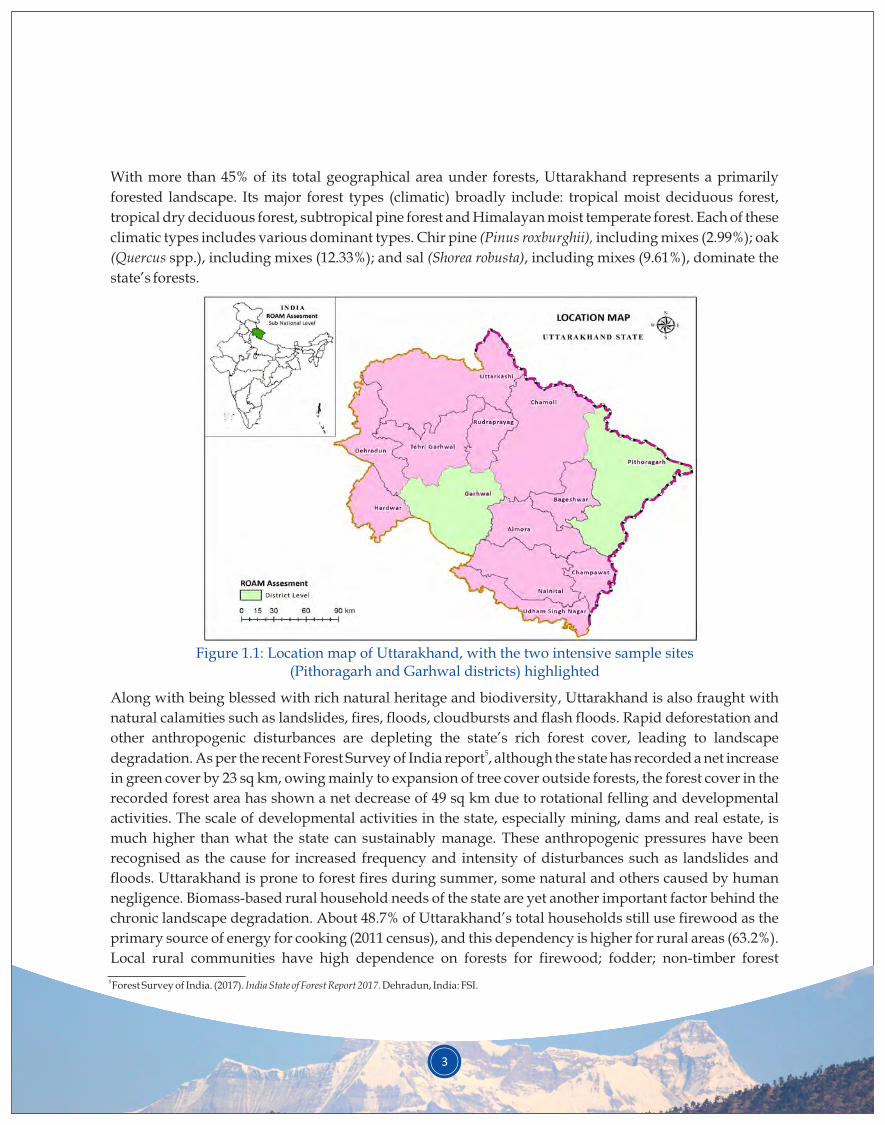
With more than 45% of its total geographical area under forests, Uttarakhand represents a primarily
forested landscape. Its major forest types (climatic) broadly include: tropical moist deciduous forest,
tropical dry deciduous forest, subtropical pine forest and Himalayan moist temperate forest. Each of these
climatic types includes various dominant types. Chir pine (Pinus roxburghii), including mixes (2.99%); oak
(Quercus spp.), including mixes (12.33%); and sal (Shorea robusta), including mixes (9.61%), dominate the
state’s forests.
Figure 1.1: Location map of Uttarakhand, with the two intensive sample sites (Pithoragarh and Garhwal districts) highlighted
Along with being blessed with rich natural heritage and biodiversity, Uttarakhand is also fraught with
natural calamities such as landslides, fires, floods, cloudbursts and flash floods. Rapid deforestation and
other anthropogenic disturbances are depleting the state’s rich forest cover, leading to landscape 5degradation. As per the recent Forest Survey of India report , although the state has recorded a net increase
in green cover by 23 sq km, owing mainly to expansion of tree cover outside forests, the forest cover in the
recorded forest area has shown a net decrease of 49 sq km due to rotational felling and developmental
activities. The scale of developmental activities in the state, especially mining, dams and real estate, is
much higher than what the state can sustainably manage. These anthropogenic pressures have been
recognised as the cause for increased frequency and intensity of disturbances such as landslides and
floods. Uttarakhand is prone to forest fires during summer, some natural and others caused by human
negligence. Biomass-based rural household needs of the state are yet another important factor behind the
chronic landscape degradation. About 48.7% of Uttarakhand’s total households still use firewood as the
primary source of energy for cooking (2011 census), and this dependency is higher for rural areas (63.2%).
Local rural communities have high dependence on forests for firewood; fodder; non-timber forest
5 Forest Survey of India. (2017). India State of Forest Report 2017. Dehradun, India: FSI.
4
products (NTFPs) such as wild edibles, flowers, lichens and medicinal plants; and occasional requirements
such as timber for repairing houses and making agricultural tools. Free grazing of livestock is also rampant
in these landscapes.
The state has a rich history of community forest management, and was one of the pioneers for the Joint 6,7Forest Management system that was introduced in various states by the Government of India. The
historical community forest system –the van panchayat (village forest council)– is still in practice in the state.
8Agriculture remains the mainstay of Uttarakhand, with nearly 14% of the area under agricultural land use.
The plains are under intensive agriculture and urban settlements, while the hill areas are largely forested,
with sparse settlements and agriculture. Hill agriculture is practiced in all altitudes but a major portion is
below 2,000 metres above sea level (m asl). Cultivable land is only 10% of the total land in hill areas, and 9rural populations are interspersed throughout the landscape.
The state is also well known for the presence of unique medicinal and aromatic plants (MAPs), which have
emerged as an important source of income generation, especially in higher altitudes. The state government
has plans to boost organic farming and develop Uttarakhand as an ‘organic state’.
Uttarakhand is also the source for many important rivers and streams that supply water not only to the
state but also to many adjoining states. The state’s fast-flowing streams and rivers are also important
sources of hydropower, attracting investments from several private and government companies.
The ROAM study has been carried out for the entire state. However, limitations of time and funds did not
allow for detailed stakeholder consultations in all 13 districts of Uttarakhand. Hence, two districts –
Pithoragarh and Garhwal were selected as intensive sample sites/districts. Located in the eastern part of
Uttarakhand with a wide altitudinal range (<500–>6,400 m asl), Pithoragarh covers most eco-climatic
conditions (i.e., sub-tropical to high-alpine) and is, therefore, representative of most of the state's eco-
climate. Eighty four percent of the district’s population resides in rural areas. Van panchayats are very
active and strong in the district. Pithoragarh is also facing a lot of developmental pressures as well as the
effects of climate change. Garhwal (popularly known as Pauri Garhwal) is in the south-west part of the
state. Agriculture covers 22.9% of the district, while 66.1% is covered by forests. Broad forest types in
Garhwal include Himalayan sub-tropical broad-leaf forests, Himalayan sub-tropical pine forests and west 10Himalayan broad-leaf forests. Both Pithoragarh and Garhwal have similar issues of land degradation,
increasing pressure on forested landscapes, increasing frequency of natural disasters, water scarcity and
out-migration. As Uttarakhand is a predominantly mountainous landscape, the two hilly rural districts are
truly representative of the state and suitable as intensive sample sites. Additional details on the two
intensive sample sites are provided in Appendix 1.
6 Anon. (1992). The Forest Problem of Kumaun. Gyanodaya Prakashan. Nainital, India: G.B. Pant Institute of Himalayan Environment & Development.7 Agarwal, A. (1996). ‘Group Size and Successful Collective Action: A Case Study of Forest Management Institutions in the Indian Himalayas’. In:
Gibson, C., McKean, M.A., and Ostrom, E. (eds), Forest Resources and Institutions, Forest Trees and People Programme – Forestry Department, Working Paper No. 3. Rome: Food and Agricultural Organization.8Bhuvan-ISRO/NSRC. ‘District and category wise distribution of land use/land cover in Uttarakhand (2011-12)’. Available at: http://bhuvan.nrsc.gov.in/gis/thematic/tools/document/LULC502/MAP/UK.pdf (Accessed: 10 May 2018). 9 Singh, S.P. and Singh, J.S. (1991). ‘Analytical conceptual plan to reforest Central Himalaya for sustainable development’. Environmental Management 15: 369-379.10Bhuvan-ISRO/NSRC. ‘District and category wise distribution of land use/land cover in Uttarakhand (2011-12)’. Available at http://bhuvan.nrsc.gov.in/gis/thematic/tools/document/LULC502/MAP/UK.pdf (Accessed: 10 May 2018).
5
1.2 Objectives of the study
The ROAM study brought together spatial analysis, insights from experts and institutions, and intensive
stakeholder consultations to help develop a roadmap for improving ecosystem services, strengthening
livelihood options, and protecting the forested landscapes of Uttarakhand.
The main outputs of the study were:
• Restoration priority map for the state of Uttarakhand
• Understanding of stakeholder perceptions on degradation and drivers
• Overview of the past restoration efforts in the state
• A suite of recommended restoration interventions suitable for different elevation gradients across
the state
The restoration opportunities assessment was conducted for the entire state of Uttarakhand, using spatial
analysis in conjunction with stakeholder consultations as per the ROAM framework. However, as the
current time and resource constraints did not permit intensive consultations for the entire state, it was
agreed that such analysis be carried out in two representative landscapes – the districts of Pithoragarh and
Garhwal.
The study adhered to the ROAM framework developed by IUCN and WRI for developing restoration
strategies at the landscape level. The ROAM approach considers forest landscape restoration an important
tool for simultaneously restoring ecological functions, improving local livelihoods and enhancing the
production and protection functions of degraded land; the implementation of this approach involves
stakeholders throughout the process.
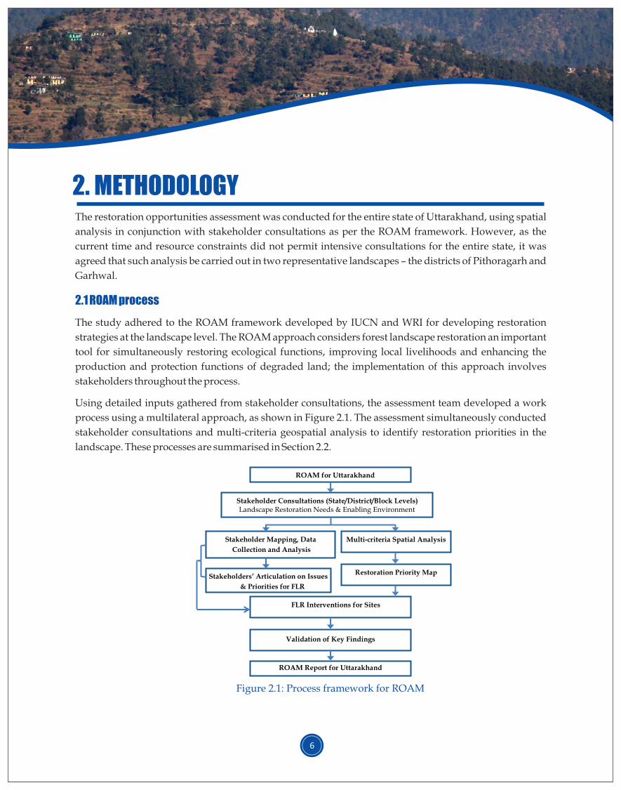
Using detailed inputs gathered from stakeholder consultations, the assessment team developed a work
process using a multilateral approach, as shown in Figure 2.1. The assessment simultaneously conducted
stakeholder consultations and multi-criteria geospatial analysis to identify restoration priorities in the
landscape. These processes are summarised in Section 2.2.
2.1 ROAM process
2. METHODOLOGY
6
Stakeholder Consultations (State/District/Block Levels) Landscape Restoration Needs & Enabling Environment
FLR Interventions for Sites
Validation of Key Findings
ROAM Report for Uttarakhand
Stakeholder Mapping, Data
Collection and Analysis
Stakeholders’ Articulation on Issues
& Priorities for FLR
Restoration Priority Map
Multi-criteria Spatial Analysis
ROAM for Uttarakhand
Figure 2.1: Process framework for ROAM
7
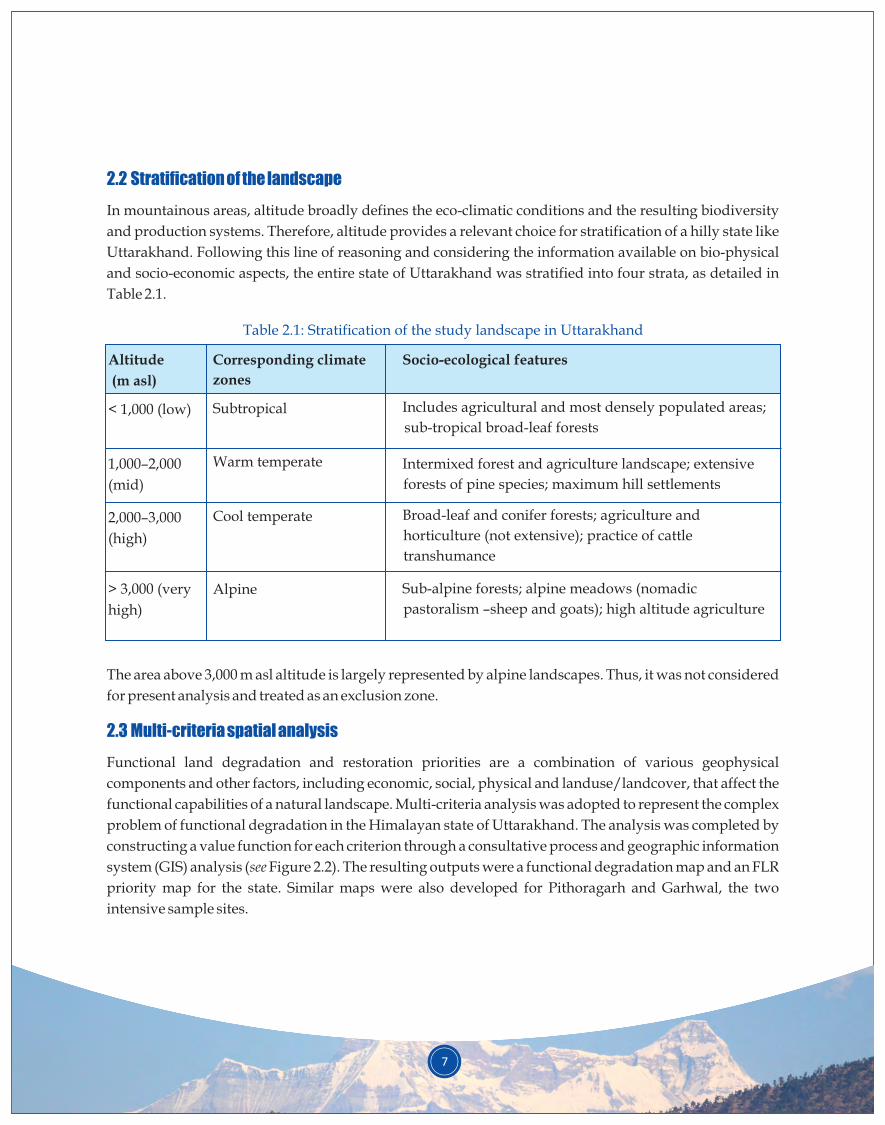
2.2 Stratification of the landscape
In mountainous areas, altitude broadly defines the eco-climatic conditions and the resulting biodiversity
and production systems. Therefore, altitude provides a relevant choice for stratification of a hilly state like
Uttarakhand. Following this line of reasoning and considering the information available on bio-physical
and socio-economic aspects, the entire state of Uttarakhand was stratified into four strata, as detailed in
Table 2.1.
Table 2.1: Stratification of the study landscape in Uttarakhand
Altitude
(m asl)
< 1,000 (low)
1,000–2,000
(mid)
2,000–3,000
(high)
> 3,000 (very
high)
Corresponding climate
zones
Subtropical
Warm temperate
Cool temperate
Alpine
Socio-ecological features
Includes agricultural and most densely populated areas;
sub-tropical broad-leaf forests
Intermixed forest and agriculture landscape; extensive
forests of pine species; maximum hill settlements
Broad-leaf and conifer forests; agriculture and
horticulture (not extensive); practice of cattle
transhumance
Sub-alpine forests; alpine meadows (nomadic
pastoralism –sheep and goats); high altitude agriculture
The area above 3,000 m asl altitude is largely represented by alpine landscapes. Thus, it was not considered
for present analysis and treated as an exclusion zone.
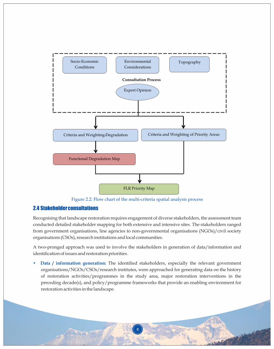
Functional land degradation and restoration priorities are a combination of various geophysical
components and other factors, including economic, social, physical and landuse/landcover, that affect the
functional capabilities of a natural landscape. Multi-criteria analysis was adopted to represent the complex
problem of functional degradation in the Himalayan state of Uttarakhand. The analysis was completed by
constructing a value function for each criterion through a consultative process and geographic information
system (GIS) analysis (see Figure 2.2). The resulting outputs were a functional degradation map and an FLR
priority map for the state. Similar maps were also developed for Pithoragarh and Garhwal, the two
intensive sample sites.
2.3 Multi-criteria spatial analysis
8
Socio-Economic
Conditions
Topography
Environmental
Considerations
Expert Opinion
Consultation Process
Criteria and Weighting of Priority Areas
Criteria and Weighting- Degradation
Functional Degradation Map
FLR Priority Map
Figure 2.2: Flow chart of the multi-criteria spatial analysis process
2.4 Stakeholder consultations
• Data / information generation:
Recognising that landscape restoration requires engagement of diverse stakeholders, the assessment team
conducted detailed stakeholder mapping for both extensive and intensive sites. The stakeholders ranged
from government organisations, line agencies to non-governmental organisations (NGOs)/civil society
organisations (CSOs), research institutions and local communities.
A two-pronged approach was used to involve the stakeholders in generation of data/information and
identification of issues and restoration priorities.
The identified stakeholders, especially the relevant government
organisations/NGOs/CSOs/research institutes, were approached for generating data on the history
of restoration activities/programmes in the study area, major restoration interventions in the
preceding decade(s), and policy/programme frameworks that provide an enabling environment for
restoration activities in the landscape.
9
• Identification of issues and restoration priorities: To this end, the assessment team organised a series
of consultations at the state level as well as in the intensive sample sites of Pithoragarh and Garhwal
districts. At the intensive sites, consultations were organised at district and block levels. These
consultations attempted to involve three levels of stakeholders: (a) first level (or direct) beneficiaries,
including stakeholders who have direct interest in landscape resources for their sustenance and
livelihoods, such as communities and people's representatives; (b) second level (or indirect)
beneficiaries, including stakeholders with an indirect interest in landscape resources, such as relevant
government agencies, research institutions and institutions concerned with management of resources
through relevant programmes; and (c) third-level beneficiaries, including individuals or organisations
that may not be directly affected by or have direct influence on the restoration process but are
influential and may contribute to the process, such as local entrepreneurs, teachers and government
organisations/NGOs not directly involved.
The assessment team completed the stakeholder consultations in both the districts during April–October
2017 (Appendix 2). The consultations were always held under the chairmanship of a senior government
representative of the most relevant government department/line agency. For instance, at the state level, it
was usually the head of the forest department, the key stakeholder. In the districts, the consultations were
chaired by the District Magistrate, the administrative head of the district. The identified priorities were
further discussed and validated in district level (intensive site) consultations with primary beneficiaries in
November 2017. Of the total stakeholders consulted in the districts, about 30% were women. A summary of
stakeholder consultations is provided in Table 2.2, below.
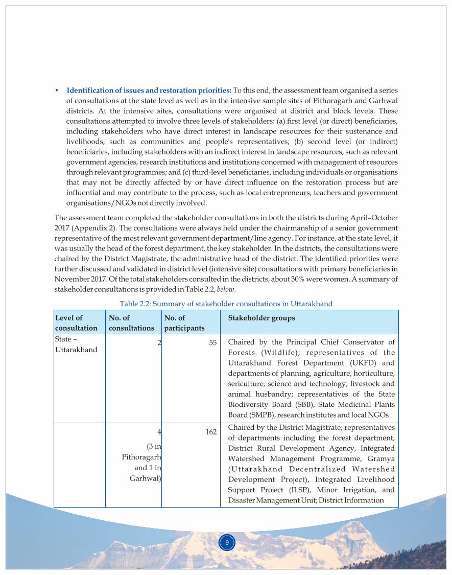
Table 2.2: Summary of stakeholder consultations in Uttarakhand
Level of
consultation
State –
Uttarakhand
No. of
consultations
2
4
(3 in
Pithoragarh
and 1 in
Garhwal)
Stakeholder groups
Chaired by the Principal Chief Conservator of
Forests (Wildlife); representatives of the
Uttarakhand Forest Department (UKFD) and
departments of planning, agriculture, horticulture,
sericulture, science and technology, livestock and
animal husbandry; representatives of the State
Biodiversity Board (SBB), State Medicinal Plants
Board (SMPB), research institutes and local NGOs
Chaired by the District Magistrate; representatives
of departments including the forest department,
District Rural Development Agency, Integrated
Watershed Management Programme, Gramya
(Ut tarakhand Decentra l ized Watershed
Development Project), Integrated Livelihood
Support Project (ILSP), Minor Irrigation, and
Disaster Management Unit; District Information
No. of
participants
55
162
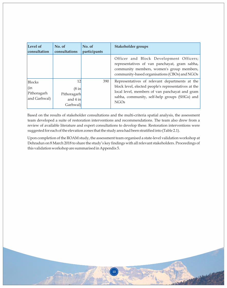
Level of
consultation
Blocks
(in
Pithoragarh
and Garhwal)
No. of
consultations
12
(8 in
Pithoragarh
and 4 in
Garhwal)
Stakeholder groups
Officer and Block Development Officers;
representatives of van panchayat, gram sabha,
community members, women's group members,
community-based organisations (CBOs) and NGOs
Representatives of relevant departments at the
block level, elected people's representatives at the
local level, members of van panchayat and gram
sabha, community, self-help groups (SHGs) and
NGOs
No. of
participants
390
Based on the results of stakeholder consultations and the multi-criteria spatial analysis, the assessment
team developed a suite of restoration interventions and recommendations. The team also drew from a
review of available literature and expert consultations to develop these. Restoration interventions were
suggested for each of the elevation zones that the study area had been stratified into (Table 2.1).
Upon completion of the ROAM study, the assessment team organised a state-level validation workshop at
Dehradun on 8 March 2018 to share the study’s key findings with all relevant stakeholders. Proceedings of
this validation workshop are summarised in Appendix 5.
10
3.1 Summary of stakeholder consultations
As part of the assessment process, the study team carried out two stakeholder consultations at the state
level to help define the objectives and priorities for the ROAM study. Detailed stakeholder consultations
were held at both district and individual block level in Pithoragarh and Garhwal districts, the two
intensive sample sites. These consultations provided insights into the community’s perceptions about the
major drivers of landscape degradation and the consequences of such degradation. The community’s
suggestions for addressing the degradation were also distilled from the consultations, and these formed a
major input for the suggested suite of restoration interventions for each elevation zone (see Chapter 6).
The stakeholders identified the following as the major drivers of forest landscape degradation:
• Forest fires: Forest fires were identified as the most important driver of landscape degradation in
75% blocks of Pithoragarh and 93% blocks of Garhwal.
• Anthropogenic pressure: A significant 75% blocks of Pithoragarh and 86% blocks of Garhwal listed
anthropogenic pressure on forests for resources such as fuelwood, fodder, timber, water and
NTFPs as a major driver of degradation.
• Fodder scarcity: In 62% blocks of Pithoragarh and 50% blocks of Garhwal, scarcity of fodder was
identified as a grave issue and a cause for forest landscape degradation in the region.
• Landslides: In 50% blocks of each of the two districts, disasters such as landslides were seen to
cause severe degradation of the landscape.
• In Garhwal district, 93% blocks also felt that invasion of natural broad-leaf forests by unwanted
species, especially chir pine species, was a significant driver of forest landscape degradation. Free
grazing was considered a major driver of degradation in 62% blocks of Garhwal.
The stakeholders listed the following as the major consequences of degradation:
• Water scarcity: Scarcity of water was pointed to as an important consequence of landscape
degradation by 75% blocks of Pithoragarh and 93% blocks of Garhwal.
• Human-wildlife conflict: A significant 75% blocks of Pithoragarh and 86% blocks of Garhwal felt
that human-wildlife conflict was increasing due to landscape degradation.
• Apart from these two major consequences, the two intensive sample sites also listed out-migration
from villages and decreasing livelihood opportunities as other consequences of landscape
degradation.
Communities in both the districts made the following suggestions to combat and manage degradation:
3. LANDSCAPE CHALLENGES
11
12
• Provision of adequate support (financial and technical) to van panchayats
• Selection of appropriate species and know-how for plantation/restoration activities
• Greater participation of women and youth in forest management and restoration
• Better maintenance and adequate post-plantation care of restored areas
The key causes or drivers of degradation in the study landscape, as identified by literature review and
stakeholder consultations, can be grouped as follows: (i) forest fires, (ii) invasion by unwanted species,
especially chir pine, (iii) free livestock grazing, (iv) landslides, (v) forest degradation due to increasing
anthropogenic pressure and (vi) increasing community apathy towards agriculture and forest
management. Each of these factors is briefly discussed below.
The state of Uttarakhand has a history of forest fire incidents, with prolonged drought being identified as a
factor associated with forest fires in the last century. Recent years have also witnessed a series of forest
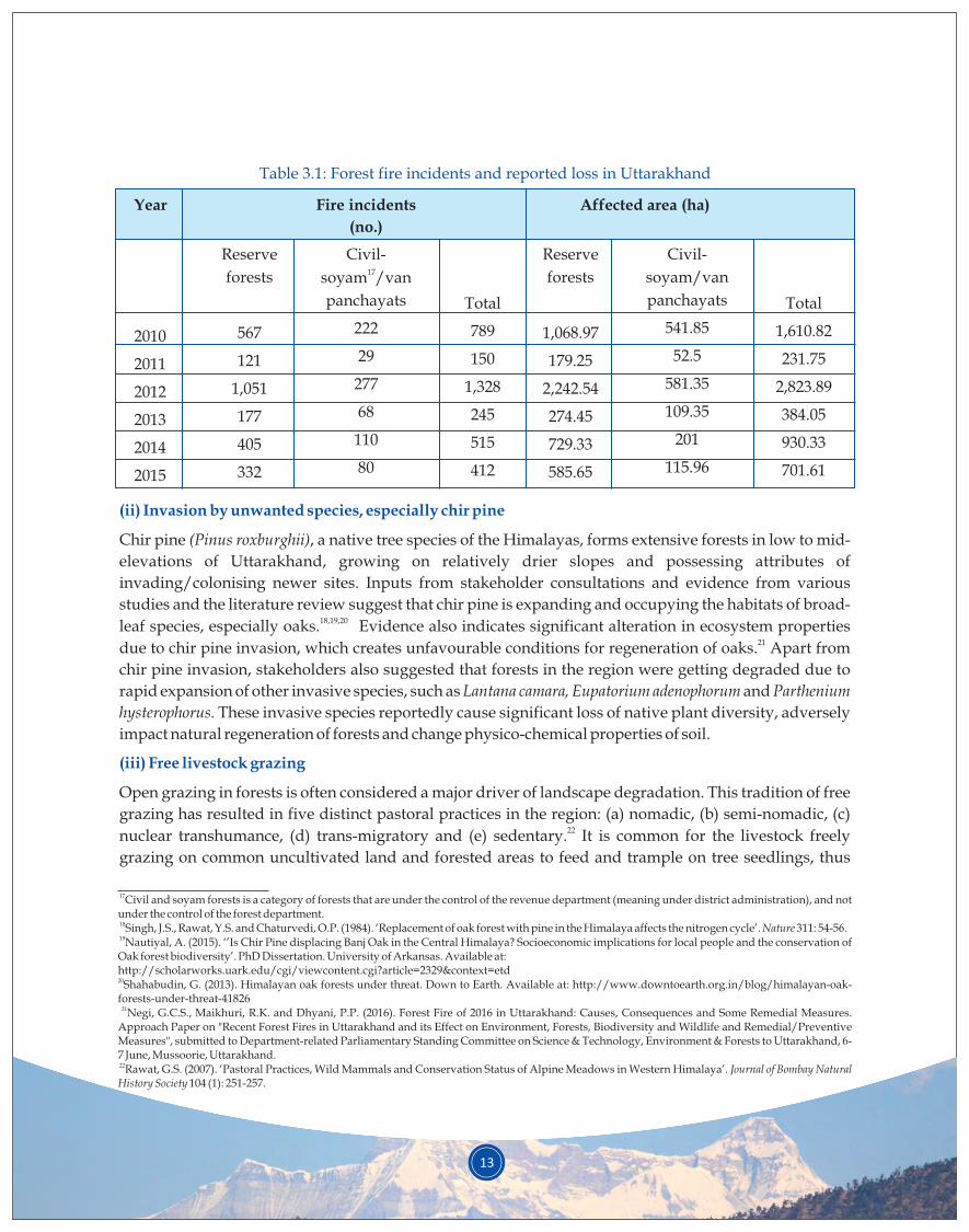
fires in the state. Table 3.1 provides details of forest fire incidents during the years 2010 to 2015; 2016 was a 11record year with a total of 1,327 forest fire incidents across Uttarakhand. Severe forest fire incidences in
the state are attributed to a combination of factors: reduced rainfall and increased temperature in summer 12months coinciding with the leaf fall period of major tree species that form the forest in the region. The
fires not only result in death of standing stock and mortality of young trees but also cause potential
changes in the forest’s original composition, including increased possibility of invasion by unwanted 13,14 species, which is well documented by research on regeneration patterns in the region. The thick smoke
generated by forest fires also adds high concentration of greenhouse gases into the atmosphere, adding to
the problem of global warming and climate change. Importantly, burning of vegetation reduces the 15carbon sink potential of forests.
Both of the intensive sample sites, Pithoragarh and Garhwal, have frequent fire incidents that cause
degradation of natural forests. The frequency and intensity of forest fires in the state can be gauged from 16Table 3.1, below.
3.2 Summary of degradation drivers facing Uttarakhand
(i) Forest fires
11Negi, G.C.S., Maikhuri, R.K. and Dhyani, P.P. (2016). Forest Fire of 2016 in Uttarakhand: Causes, Consequences and Some Remedial Measures. Approach Paper on "Recent Forest Fires in Uttarakhand and its Effect on Environment, Forests, Biodiversity and Wildlife and Remedial/Preventive Measures", submitted to Department-related Parliamentary Standing Committee on Science & Technology, Environment & Forests to Uttarakhand, 6-7 June, Mussoorie, Uttarakhand.12 Sharma, S. and Pant, H. (2017). ‘Vulnerability of Indian Central Himalayan Forests to Fire in a Warming Climate and a Participatory Preparedness Approach Based on Modern Tools’. Current science 112 (10): 2100-2105. Available at DOI: 10.18520/cs/v112/i10/2100-2105.13 Sharma, S. and Rikhari, H.C. (1997). ‘Forest fire in the central Himalaya: climate and recovery of trees’. International Journal of Biometeorology 40(2): 63-70.14Ilyas, O. and Khan, J.A. (2005). ‘Assessment of tree mortality and post fire regeneration pattern in Binsar Wildlife Sanctuary Kumaon Himalaya’. Tropical Ecology 46(2): 157-163.15 rdAnon. (2017). 293 Report of Department Related Parliamentary Standing Committee on Science &Technology. Environment & Forests, Government of India. 16 Anon. (2016). Crisis management plan. Forest Department, Government of Uttarakhand.
13
Table 3.1: Forest fire incidents and reported loss in Uttarakhand
Year
2010
2011
2012
2013
2014
2015
Affected area (ha)Fire incidents
(no.)
Civil-17soyam /van
panchayats
222
29
277
68
110
80
Reserve
forests
567
121
1,051
177
405
332
Total
789
150
1,328
245
515
412
Reserve
forests
1,068.97
179.25
2,242.54
274.45
729.33
585.65
Civil-
soyam/van
panchayats
541.85
52.5
581.35
109.35
201
115.96
Total
1,610.82
231.75
2,823.89
384.05
930.33
701.61
(ii) Invasion by unwanted species, especially chir pine
(iii) Free livestock grazing
Chir pine (Pinus roxburghii), a native tree species of the Himalayas, forms extensive forests in low to mid-
elevations of Uttarakhand, growing on relatively drier slopes and possessing attributes of
invading/colonising newer sites. Inputs from stakeholder consultations and evidence from various
studies and the literature review suggest that chir pine is expanding and occupying the habitats of broad-18,19,20leaf species, especially oaks. Evidence also indicates significant alteration in ecosystem properties
21due to chir pine invasion, which creates unfavourable conditions for regeneration of oaks. Apart from
chir pine invasion, stakeholders also suggested that forests in the region were getting degraded due to
rapid expansion of other invasive species, such as Lantana camara, Eupatorium adenophorum and Parthenium
hysterophorus. These invasive species reportedly cause significant loss of native plant diversity, adversely
impact natural regeneration of forests and change physico-chemical properties of soil.
Open grazing in forests is often considered a major driver of landscape degradation. This tradition of free
grazing has resulted in five distinct pastoral practices in the region: (a) nomadic, (b) semi-nomadic, (c) 22nuclear transhumance, (d) trans-migratory and (e) sedentary. It is common for the livestock freely
grazing on common uncultivated land and forested areas to feed and trample on tree seedlings, thus
17Civil and soyam forests is a category of forests that are under the control of the revenue department (meaning under district administration), and not under the control of the forest department.18 Singh, J.S., Rawat, Y.S. and Chaturvedi, O.P. (1984). ‘Replacement of oak forest with pine in the Himalaya affects the nitrogen cycle’. Nature 311: 54-56.
19Nautiyal, A. (2015). ‘’Is Chir Pine displacing Banj Oak in the Central Himalaya? Socioeconomic implications for local people and the conservation of Oak forest biodiversity’. PhD Dissertation. University of Arkansas. Available at:http://scholarworks.uark.edu/cgi/viewcontent.cgi?article=2329&context=etd20Shahabudin, G. (2013). Himalayan oak forests under threat. Down to Earth. Available at: http://www.downtoearth.org.in/blog/himalayan-oak-forests-under-threat-41826
21 Negi, G.C.S., Maikhuri, R.K. and Dhyani, P.P. (2016). Forest Fire of 2016 in Uttarakhand: Causes, Consequences and Some Remedial Measures. Approach Paper on "Recent Forest Fires in Uttarakhand and its Effect on Environment, Forests, Biodiversity and Wildlife and Remedial/Preventive Measures", submitted to Department-related Parliamentary Standing Committee on Science & Technology, Environment & Forests to Uttarakhand, 6-7 June, Mussoorie, Uttarakhand. 22Rawat, G.S. (2007). ‘Pastoral Practices, Wild Mammals and Conservation Status of Alpine Meadows in Western Himalaya’. Journal of Bombay Natural History Society 104 (1): 251-257.
14
23,24hampering regeneration. This continuous pressure and selective feeding habits of livestock often cause 25regression of forests into scrubs with sparse and inferior grasses.
Being geo-dynamically active, the state of Uttarakhand frequently experiences natural disturbances like 26earthquakes and landslides. The entire state falls in zones IV and V, as per earthquake zonation maps.
Landslides are very common, especially during the months of monsoon. According to the landslide 27hazard zonation mapping exercise carried out for Uttarakhand , major parts in the districts of
Pithoragarh, Rudraprayag, Uttarkashi, Tehri Garhwal, and some parts of Bageshwar, Chamoli, and
Almora fall in the severe to very high-risk zones. While the majority of Garhwal district falls in the high-
risk zone, some of its high altitude regions lie in the severe to very high-risk zones.
The predominantly rural population of the landscape depends on forests for their diverse sustenance
needs. The ever-increasing biomass needs (fodder, fuel, etc.) cause additional pressure on the state’s forest
landscapes, leading to degradation. The forests witness a chronic form of disturbance, as the local
communities remove only a small fraction of forest biomass at a time, generally as head-loads of firewood,
fodder, leaf-litter and other NTFPs. However, this chronic form of forest disturbance poses a problem 28even if the rates of biomass removal are well within the carrying capacity of the forest. Plants or
ecosystems do not have time to adequately recover, as the human onslaught never ceases and can cause
adverse changes in the forest. Such chronic forms of disturbance also impact the natural regeneration 29 process, leading to considerable degradation of the landscape. A study report indicates that in one of the
watersheds within Pithoragarh district, firewood requirements vary from an average of 1,256.6 to 2,916.8
kg/household/year, and fodder requirements range between 10.5 to 21.8 kg/household/day. Chronic
forms of forest disturbance have been documented to lead to opening of forest canopies, thereby affecting 30the structure and functioning of forests. Some biomass harvesting activities are depicted in Figure 3.1,
below.
(iv) Landslides
(v) Increasing anthropogenic pressure
23Nautiyal, J.C. and Babor, P.C. (1985). ‘Forestry in the Himalayas: How to Avert an Environmental Disaster’. Interdisciplinary Science Reviews 10(1): 27-41.24Singh, G. and Rawat, G.S. (2012). ‘Depletion of Oak (Quercus spp.) Forests in the Western Himalaya: Grazing, Fuelwood and Fodder Collection’. In : Okia, C.A. (eds.). Global Perspectives on Sustainable Forest Management . In Tech Open. ISBN: 978-953-51-0569-5, DOI: 10.5772/2634 25Jackson, M.G. (1981). Livestock in the economy of the Himalayan foothills. GBPU A&T, Pantnagar.26DMMC Report (2012). State Disaster Management Action Plan for the State of Uttarakhand. Disaster Mitigation & Management Centre, Uttarakhand Secretariat, Rajpur Road, Dehradun. Available at: http://dmmc.uk.gov.in/files/pdf/complete_sdmap.pdf27Ibid28Singh, S.P. (1998). ‘Chronic disturbance, a principal cause of environmental degradation in developing countries’. Environmental Conservation, 25 (1): 1-2.29Joshi. B. (2013). Annual report of project 7. Almora: GBPIHED.30Airi, S and Rawal, R. S. (2017). ‘Patterns of vegetation composition across levels of canopy disturbance in temperate forests of west Himalaya, India’. Biodiversity: Research and Conservation 45: 21-27.
15
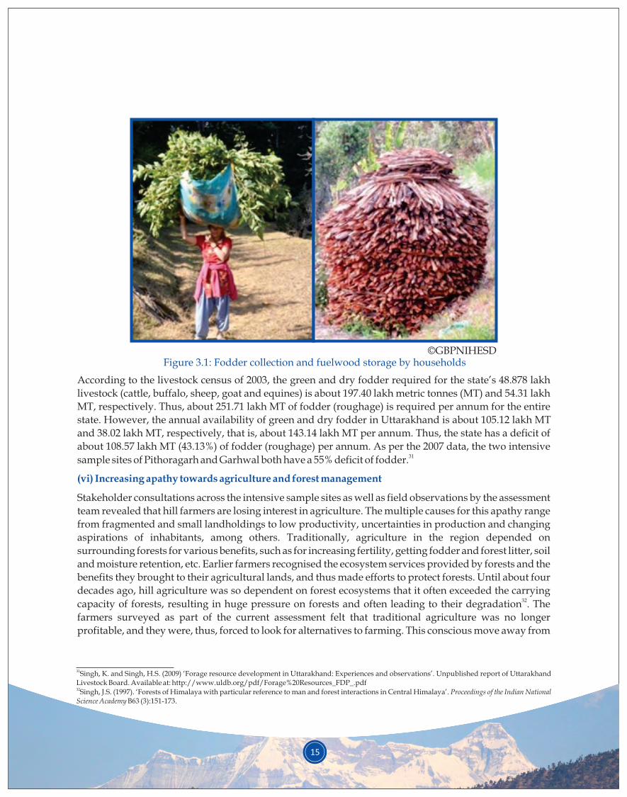
©GBPNIHESDFigure 3.1: Fodder collection and fuelwood storage by households
According to the livestock census of 2003, the green and dry fodder required for the state’s 48.878 lakh
livestock (cattle, buffalo, sheep, goat and equines) is about 197.40 lakh metric tonnes (MT) and 54.31 lakh
MT, respectively. Thus, about 251.71 lakh MT of fodder (roughage) is required per annum for the entire
state. However, the annual availability of green and dry fodder in Uttarakhand is about 105.12 lakh MT
and 38.02 lakh MT, respectively, that is, about 143.14 lakh MT per annum. Thus, the state has a deficit of
about 108.57 lakh MT (43.13%) of fodder (roughage) per annum. As per the 2007 data, the two intensive 31sample sites of Pithoragarh and Garhwal both have a 55% deficit of fodder.
Stakeholder consultations across the intensive sample sites as well as field observations by the assessment
team revealed that hill farmers are losing interest in agriculture. The multiple causes for this apathy range
from fragmented and small landholdings to low productivity, uncertainties in production and changing
aspirations of inhabitants, among others. Traditionally, agriculture in the region depended on
surrounding forests for various benefits, such as for increasing fertility, getting fodder and forest litter, soil
and moisture retention, etc. Earlier farmers recognised the ecosystem services provided by forests and the
benefits they brought to their agricultural lands, and thus made efforts to protect forests. Until about four
decades ago, hill agriculture was so dependent on forest ecosystems that it often exceeded the carrying 32capacity of forests, resulting in huge pressure on forests and often leading to their degradation . The
farmers surveyed as part of the current assessment felt that traditional agriculture was no longer
profitable, and they were, thus, forced to look for alternatives to farming. This conscious move away from
(vi) Increasing apathy towards agriculture and forest management
31Singh, K. and Singh, H.S. (2009) ‘Forage resource development in Uttarakhand: Experiences and observations’. Unpublished report of Uttarakhand Livestock Board. Available at: http://www.uldb.org/pdf/Forage%20Resources_FDP_.pdf32Singh, J.S. (1997). ‘Forests of Himalaya with particular reference to man and forest interactions in Central Himalaya’. Proceedings of the Indian National Science Academy B63 (3):151-173.
16
agriculture is leading to increased apathy towards surrounding forests, particularly community-33managed forests, leading to the poor state and health of forests.
The stakeholder consultations also identified a few consequences of degradation; these are briefly
discussed below.
For most communities in the landscape, springs are the major source of water for domestic and
agricultural use. However, these natural sources of water are now severely threatened due to several
reasons, such as changes in landuse patterns, forest degradation, changing climate and various other 34natural and anthropogenic distresses. A study has reported that nearly 8,000 villages in the Indian
Himalayas are under acute water shortage due to drying up of springs. Another scientific report, from
nearly three decades back, indicated that nearly 75% of the springs in the Kumaon region of Uttarakhand 35had gone dry, with an average 40% decline in discharge from springs from 1951 to 1986 . The report
attributed this significant decline in spring discharge to changes in land use patterns and vegetation.
The state of Uttarakhand, especially the intensive sample sites of Pithoragarh and Garhwal, have always
had a history of out-migration. However, the level of out-migration has been on the rise in recent years,
with changes in the trends, patterns and drivers of migration.
Historically, the Indo-China war of 1962 and the resulting loss of traditional livelihoods were major
drivers of out-migration. Migration now is largely driven by the impact of globalisation. Mountain
economies have been transformed from subsistence agro-based economies to monetary economies. Small
landholdings, a stagnant agriculture sector, increasing human-wildlife conflict, invasive species and
climate change are together making it increasingly difficult for hill farmers to continue their traditional 36,37 agro-based livelihoods. Interestingly, stakeholder consultations in both Pithoragarh and Garhwal
identified degradation of forest landscapes as one of the reasons for rural out-migration from the region.
This perception of the local community is an interesting finding of the ROAM study.
Increasing human-wildlife interactions (conflicts) are considered one of the most pervasive problems
across the entire state of Uttarakhand, including in the intensive sample sites.
Literature has documented different reasons for this situation. Interestingly, stakeholder consultations
from the two intensive sample sites listed landscape degradation as a major reason for the increasing
incidence of human-wildlife conflicts.
Recognised consequences of degradation:
(i) Scarcity of water/drying up of natural springs
(ii) Out-migration from villages
(iii) Human-wildlife conflict
33Germain, R., Ghosh, C. and Jayasuriya, M. (2017). ‘Community Forestry in the State of Uttarakhand, India: Not Meeting the Needs of the Villagers’. Small-scale Forestry. Available at: https://doi.org/10.1007/s11842-017-9384-z34Mahamuni, K. and Kulkarni, H. (2012). ‘Groundwater Resources and Spring Hydrogeology in South Sikkim, with Special Reference to Climate Change’. In: Arrawatia. M.L. and Tambe, S. (eds.) Climate change in Sikkim - Patterns, Impacts and Initiatives, pp. 261-274. Gangtok: Information and Public Relations Department, Government of Sikkim.35Valdiya, K.S. and Bartarya, S.K. (1989). ‘Diminishing discharge of mountain springs in a part of Kumaun Himalaya’. Current Science 58: 417–426.36Pathak, S., Pant, L. and Mahajan, A. (2017). Depopulation trends, patterns and effects. Nepal: ICIMOD.37Mamgain, R.P. and Reddy, D.N. (2015). Outmigration from hill region of Uttarakhand: Magnitude, Challenges and Policy Options. Hyderabad: National Institute of Rural Development and Panchayati Raj. Available at: http://www.nird.org.in/nird_docs/srsc/srscrr261016-3.pdf
17
(iv)Decreasing livelihood opportunities
The indigenous local communities of Uttarakhand are highly dependent on their surrounding forests and
are greatly affected by deforestation and forest degradation. Degradation of forest resources affects all the
links of their ecological and economic chain. For instance, loss of green fodder affects animal husbandry
and livestock farming. Similarly, degradation of forest canopy results in depletion of useful medicinal
plants found under the forest canopy, which form a source of additional income for many hill
communities. Degradation of forests may also cause a decline in the fertility of adjoining agriculture lands.
Thus, degradation of forest landscapes has a strong and adverse impact on the daily survival and 38subsistence of local communities residing in the region.
38Bisht, R. (2002). Environmental health in Garhwal Himalaya: a study of Pauri Garhwal. New Delhi, India: Indus Publishing.
Forest landscapes of Uttarakhand play a direct role in supporting rural lives, not only by meeting local
communities’ day-to-day needs of fuel, fodder and timber but also by providing employment through
forest-based activities and collection of NTFPs. However, increasing demands on forest landscapes have 39led to large-scale anthropogenic destruction in many parts of Uttarakhand and, consequently, the
ecosystem services (benefits) provided by these forests have reduced considerably. This has led to the
situation that prevails today, marked by widespread water scarcity and drought, degraded broad-leaf
forests and loss of ecosystem services.
Struggles and movements for natural resource conservation and local livelihood needs have been part of
hill people’s lives for decades. Some movements like Chipko (hugging trees to save them from being
chopped) and Chheeno Jhapto (snatching tools of tree cutters) are particularly notable in this regard. The
state of Uttarakhand has also witnessed the unique local practice of conserving certain landscapes –
forests, grasslands, wetlands and sometimes riverbanks – by associating them with spiritual and cultural
sentiments, often by offering the said landscape to a local deity, thus making it a sacred landscape. These
forests are considered dwellings of gods and deities. Such dev-van or sacred groves once dotted the forest
landscape of Uttarakhand, especially in remote areas.
As local livelihoods were directly and deeply interlinked with the surrounding resources and the areas
were fairly inaccessible, systems of natural resource management were deeply entrenched in local
cultures. Local systems of resource management included van panchayats, lath panchayats and other forms
of community forestry like mahila mangal dals (village women’s associations), informal van samitis and
youth groups.
Over the years, several efforts have been made to restore Uttarakhand’s forest landscapes. Both
government departments as well as other organisations have worked toward this end. The government
departments/programmes include the forest department, soil and agriculture department, horticulture
department, irrigation department, the Mahatma Gandhi National Rural Employment Guarantee Act
(MGNREGA), Gramya (Watershed Management Directorate [WMD]) and the unique Eco-Task Force. A
summary of major restoration efforts in the state and the two intensive sample districts are provided in
Tables 4.1, 4.2 and 4.3. Appendix 3 provides information on the restoration efforts of other agencies.
4. OVERVIEW OF RESTORATION EFFORTS IN UTTARAKHAND
18
39Dangwal, D.D. (2005). ‘Commercialisation of Forests, Timber Extraction and Deforestation in Uttaranchal, 1815-1947’. Conservation and Society 3(1): 110-133.40Nagarwalla, D.J. and Agrawal, A. (2009). ‘Uttarakhand State Chapter’. In: Pathak, N. (ed.) Community Conserved Areas in India - A Directory, pp.707-730. Pune/ Delhi: Kalpavriksh.
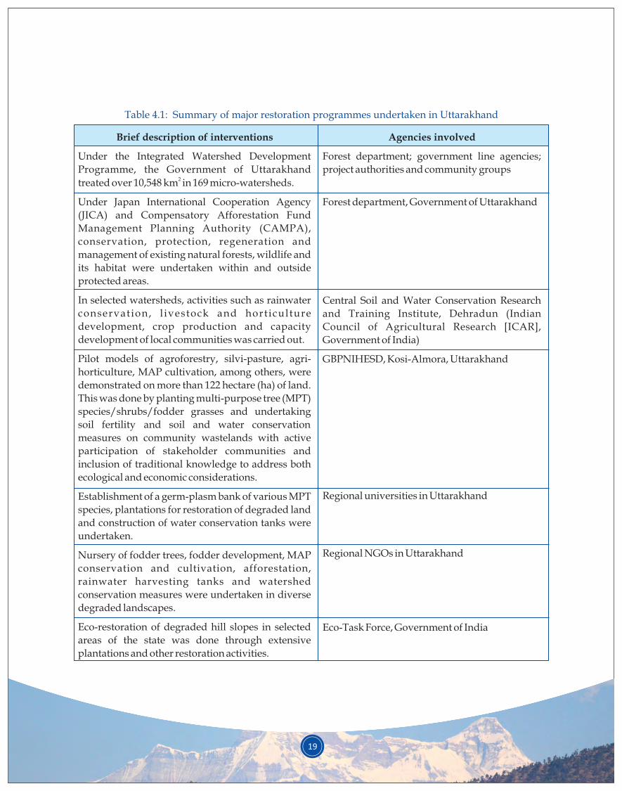
19
Under the Integrated Watershed Development
Programme, the Government of Uttarakhand 2treated over 10,548 km in 169 micro-watersheds.
Under Japan International Cooperation Agency
(JICA) and Compensatory Afforestation Fund
Management Planning Authority (CAMPA),
conservation, protection, regeneration and
management of existing natural forests, wildlife and
its habitat were undertaken within and outside
protected areas.
In selected watersheds, activities such as rainwater
conservation, l ivestock and horticulture
development, crop production and capacity
development of local communities was carried out.
Pilot models of agroforestry, silvi-pasture, agri-
horticulture, MAP cultivation, among others, were
demonstrated on more than 122 hectare (ha) of land.
This was done by planting multi-purpose tree (MPT)
species/shrubs/fodder grasses and undertaking
soil fertility and soil and water conservation
measures on community wastelands with active
participation of stakeholder communities and
inclusion of traditional knowledge to address both
ecological and economic considerations.
Establishment of a germ-plasm bank of various MPT
species, plantations for restoration of degraded land
and construction of water conservation tanks were
undertaken.
Nursery of fodder trees, fodder development, MAP
conservation and cultivation, afforestation,
rainwater harvesting tanks and watershed
conservation measures were undertaken in diverse
degraded landscapes.
Eco-restoration of degraded hill slopes in selected
areas of the state was done through extensive
plantations and other restoration activities.
Forest department; government line agencies;
project authorities and community groups
Forest department, Government of Uttarakhand
Central Soil and Water Conservation Research
and Training Institute, Dehradun (Indian
Council of Agricultural Research [ICAR],
Government of India)
GBPNIHESD, Kosi-Almora, Uttarakhand
Regional universities in Uttarakhand
Regional NGOs in Uttarakhand
Eco-Task Force, Government of India
Table 4.1: Summary of major restoration programmes undertaken in Uttarakhand
Brief description of interventions Agencies involved
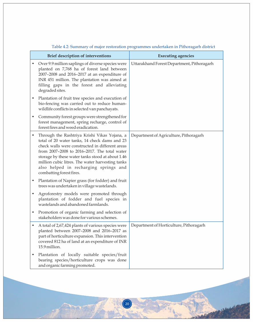
• Over 9.9 million saplings of diverse species were
planted on 7,768 ha of forest land between
2007–2008 and 2016–2017 at an expenditure of
INR 451 million. The plantation was aimed at
filling gaps in the forest and alleviating
degraded sites.
• Plantation of fruit tree species and execution of
bio-fencing was carried out to reduce human-
wildlife conflicts in selected van panchayats.
• Community forest groups were strengthened for
forest management, spring recharge, control of
forest fires and weed eradication.
• Through the Rashtriya Krishi Vikas Yojana, a
total of 20 water tanks, 14 check dams and 23
check walls were constructed in different areas
from 2007–2008 to 2016–2017. The total water
storage by these water tanks stood at about 1.46
million cubic litres. The water harvesting tanks
also helped in recharging springs and
combatting forest fires.
• Plantation of Napier grass (for fodder) and fruit
trees was undertaken in village wastelands.
• Agroforestry models were promoted through
plantation of fodder and fuel species in
wastelands and abandoned farmlands.
• Promotion of organic farming and selection of
stakeholders was done for various schemes.
• A total of 2,67,424 plants of various species were
planted between 2007–2008 and 2016–2017 as
part of horticulture expansion. This intervention
covered 812 ha of land at an expenditure of INR
15.9 million.
• Plantation of locally suitable species/fruit
bearing species/horticulture crops was done
and organic farming promoted.
Uttarakhand Forest Department, Pithoragarh
Department of Agriculture, Pithoragarh
Department of Horticulture, Pithoragarh
Table 4.2: Summary of major restoration programmes undertaken in Pithoragarh district
Brief description of interventions Executing agencies
20
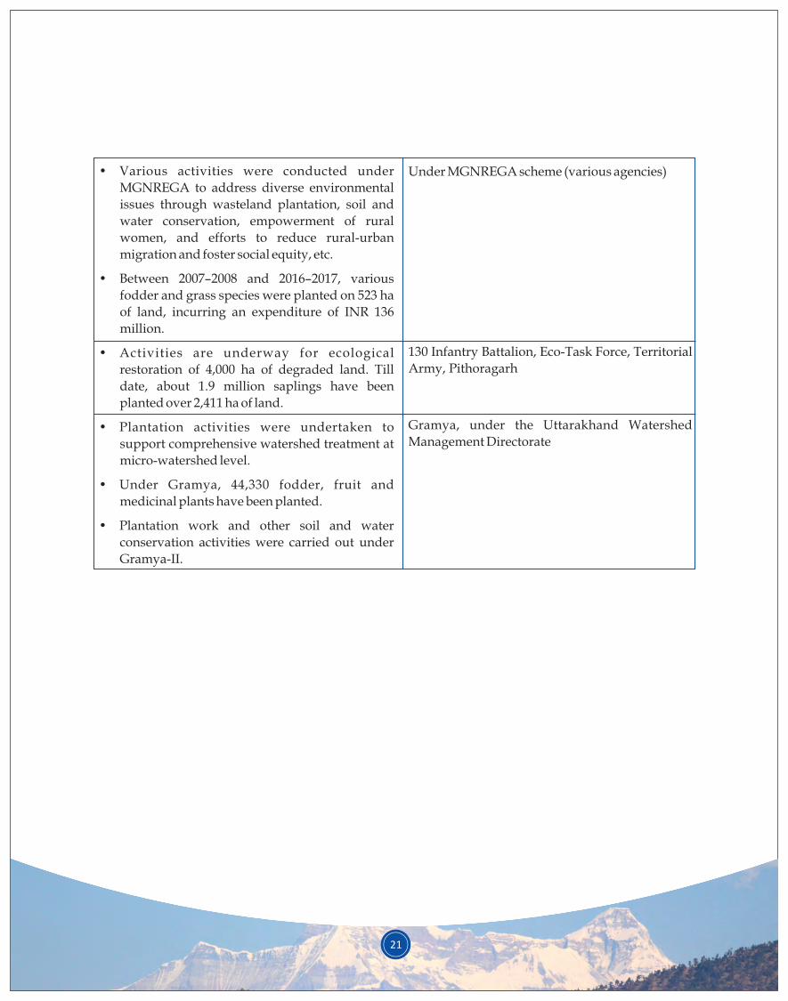
21
• Various activities were conducted under
MGNREGA to address diverse environmental
issues through wasteland plantation, soil and
water conservation, empowerment of rural
women, and efforts to reduce rural-urban
migration and foster social equity, etc.
• Between 2007–2008 and 2016–2017, various
fodder and grass species were planted on 523 ha
of land, incurring an expenditure of INR 136
million.
• Activities are underway for ecological
restoration of 4,000 ha of degraded land. Till
date, about 1.9 million saplings have been
planted over 2,411 ha of land.
• Plantation activities were undertaken to
support comprehensive watershed treatment at
micro-watershed level.
• Under Gramya, 44,330 fodder, fruit and
medicinal plants have been planted.
• Plantation work and other soil and water
conservation activities were carried out under
Gramya-II.
Under MGNREGA scheme (various agencies)
130 Infantry Battalion, Eco-Task Force, Territorial
Army, Pithoragarh
Gramya, under the Uttarakhand Watershed
Management Directorate
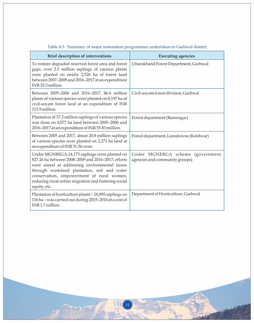
22
To restore degraded reserved forest area and forest
gaps, over 2.5 million saplings of various plants
were planted on nearly 2,526 ha of forest land
between 2007–2008 and 2016–2017 at an expenditure
INR 35.3 million.
Between 2005–2006 and 2016–2017, 86.6 million
plants of various species were planted on 8,197 ha of
civil-soyam forest land at an expenditure of INR
113.9 million.
Plantation of 37.2 million saplings of various species
was done on 4,077 ha land between 2005–2006 and
2016–2017 at an expenditure of INR 55.83 million.
Between 2005 and 2017, about 20.8 million saplings
of various species were planted on 2,271 ha land at
an expenditure of INR 31.56 crore.
Under MGNREGA,14,173 saplings were planted on
827.26 ha between 2008–2009 and 2016–2017; efforts
were aimed at addressing environmental issues
through wasteland plantation, soil and water
conservation, empowerment of rural women,
reducing rural-urban migration and fostering social
equity, etc.
Plantation of horticulture plants – 18,895 saplings on
116 ha – was carried out during 2015–2016 at a cost of
INR 1.7 million.
Uttarakhand Forest Department, Garhwal
Civil-soyam forest division, Garhwal
Forest department (Ramnagar)
Forest department, Lansdowne (Kotdwar)
Under MGNERGA scheme (government
agencies and community groups)
Department of Horticulture, Garhwal
Table 4.3: Summary of major restoration programmes undertaken in Garhwal district
Brief description of interventions Executing agencies
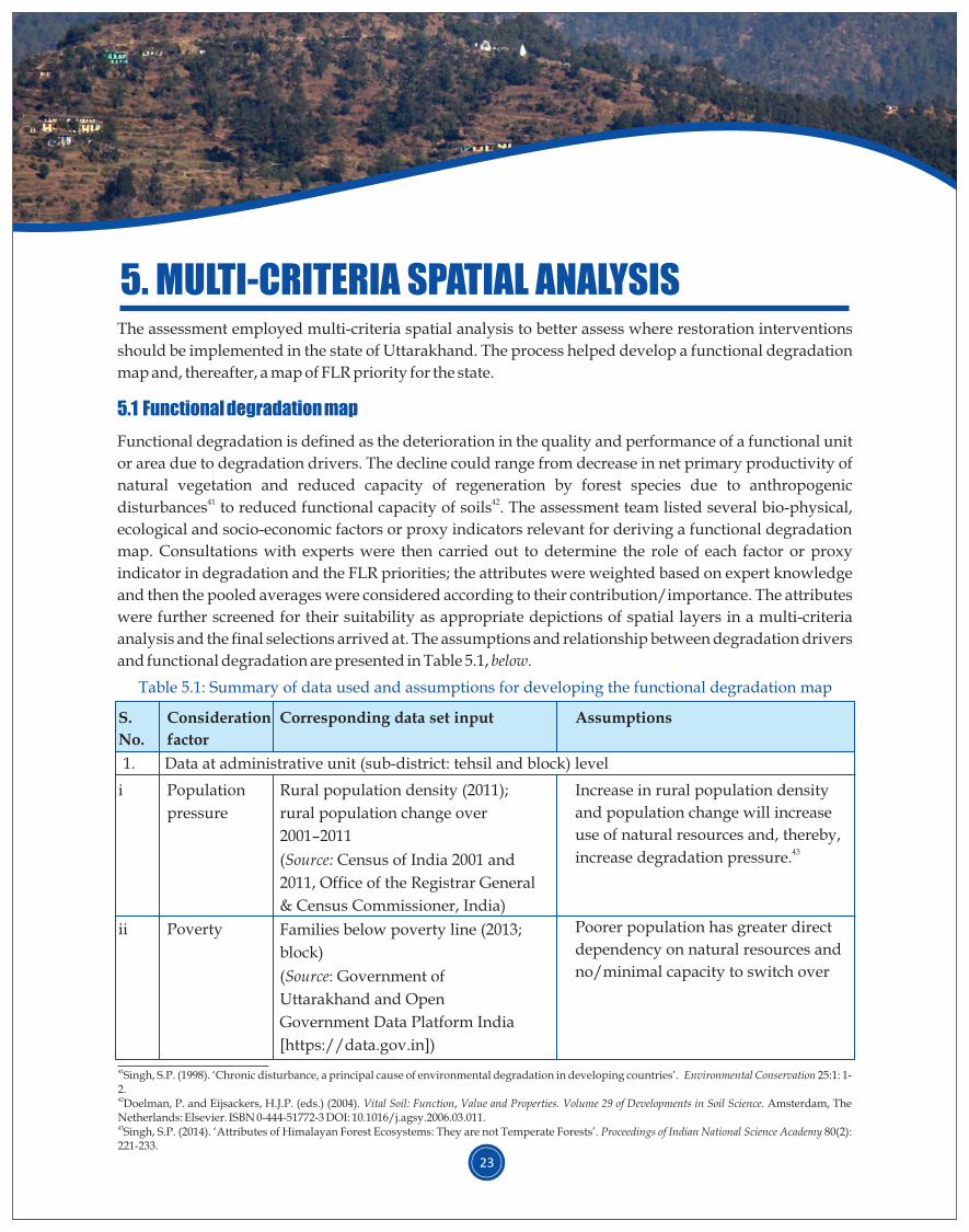
The assessment employed multi-criteria spatial analysis to better assess where restoration interventions
should be implemented in the state of Uttarakhand. The process helped develop a functional degradation
map and, thereafter, a map of FLR priority for the state.
Functional degradation is defined as the deterioration in the quality and performance of a functional unit
or area due to degradation drivers. The decline could range from decrease in net primary productivity of
natural vegetation and reduced capacity of regeneration by forest species due to anthropogenic 41 42disturbances to reduced functional capacity of soils . The assessment team listed several bio-physical,
ecological and socio-economic factors or proxy indicators relevant for deriving a functional degradation
map. Consultations with experts were then carried out to determine the role of each factor or proxy
indicator in degradation and the FLR priorities; the attributes were weighted based on expert knowledge
and then the pooled averages were considered according to their contribution/importance. The attributes
were further screened for their suitability as appropriate depictions of spatial layers in a multi-criteria
analysis and the final selections arrived at. The assumptions and relationship between degradation drivers
and functional degradation are presented in Table 5.1, below.
5.1 Functional degradation map
5. MULTI-CRITERIA SPATIAL ANALYSIS
23
S.
No.
Consideration
factor
AssumptionsCorresponding data set input
1. Data at administrative unit (sub-district: tehsil and block) level
i Population
pressure
Increase in rural population density
and population change will increase
use of natural resources and, thereby, 43increase degradation pressure.
Poorer population has greater direct
dependency on natural resources and
no/minimal capacity to switch over
Rural population density (2011);
rural population change over
2001–2011
(Source: Census of India 2001 and
2011, Office of the Registrar General
& Census Commissioner, India)
Families below poverty line (2013;
block)
(Source: Government of
Uttarakhand and Open
Government Data Platform India
[https://data.gov.in])
ii Poverty
41Singh, S.P. (1998). ‘Chronic disturbance, a principal cause of environmental degradation in developing countries’. Environmental Conservation 25:1: 1-2.42Doelman, P. and Eijsackers, H.J.P. (eds.) (2004). Vital Soil: Function, Value and Properties. Volume 29 of Developments in Soil Science. Amsterdam, The Netherlands: Elsevier. ISBN 0-444-51772-3 DOI: 10.1016/j.agsy.2006.03.011.43Singh, S.P. (2014). ‘Attributes of Himalayan Forest Ecosystems: They are not Temperate Forests’. Proceedings of Indian National Science Academy 80(2): 221-233.
Table 5.1: Summary of data used and assumptions for developing the functional degradation map
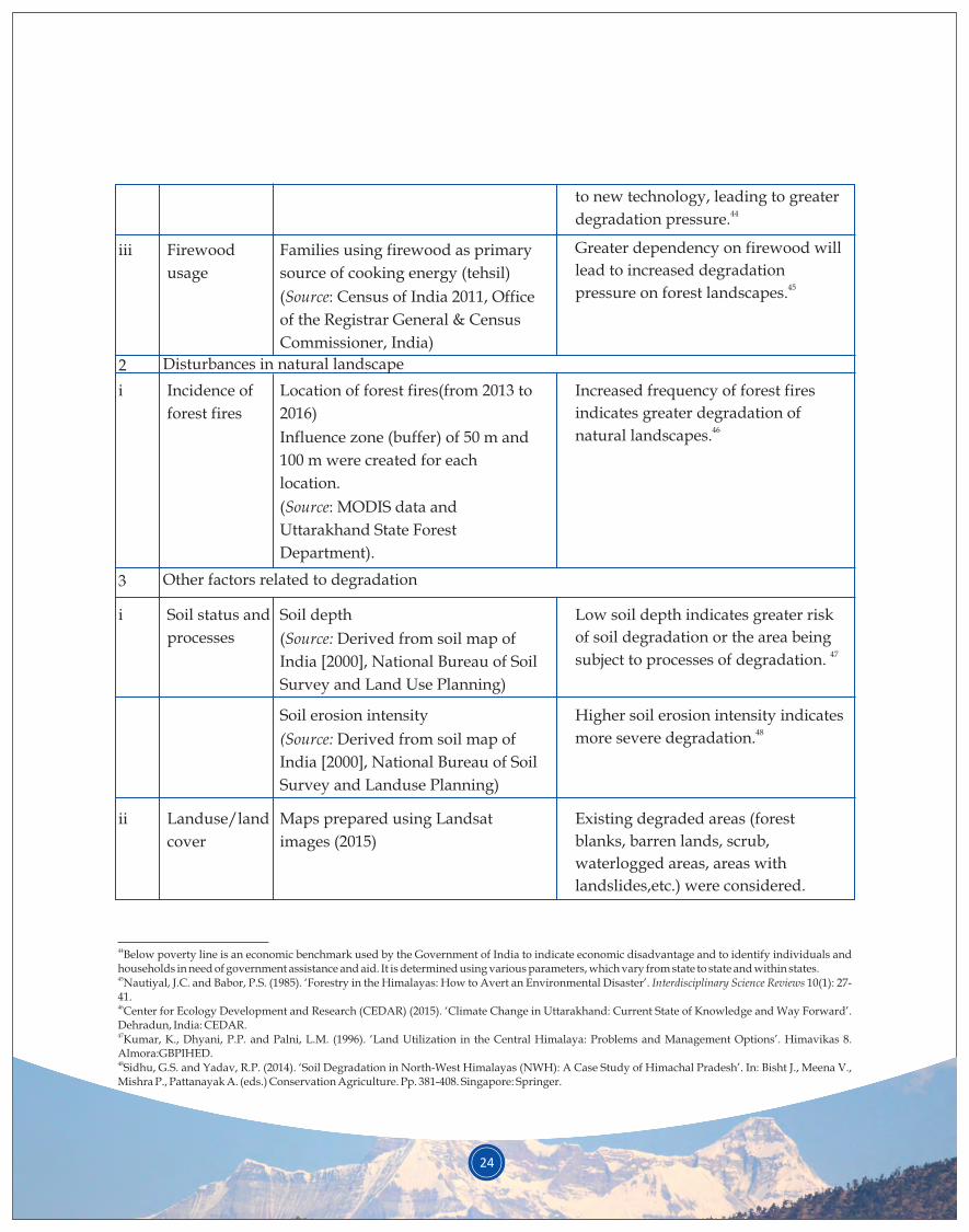
24
iii Firewood
usage
to new technology, leading to greater 44degradation pressure.
Greater dependency on firewood will
lead to increased degradation 45pressure on forest landscapes.
Families using firewood as primary
source of cooking energy (tehsil)
(Source: Census of India 2011, Office
of the Registrar General & Census
Commissioner, India)
Incidence of
forest fires
Increased frequency of forest fires
indicates greater degradation of 46natural landscapes.
Location of forest fires(from 2013 to
2016)
Influence zone (buffer) of 50 m and
100 m were created for each
location.
(Source: MODIS data and
Uttarakhand State Forest
Department).
2 Disturbances in natural landscape
3 Other factors related to degradation
Soil status and
processes
Landuse/land
cover
Low soil depth indicates greater risk
of soil degradation or the area being 47subject to processes of degradation.
Soil depth
(Source: Derived from soil map of
India [2000], National Bureau of Soil
Survey and Land Use Planning)
ii
Higher soil erosion intensity indicates 48 more severe degradation.
Existing degraded areas (forest
blanks, barren lands, scrub,
waterlogged areas, areas with
landslides,etc.) were considered.
Soil erosion intensity
(Source: Derived from soil map of
India [2000], National Bureau of Soil
Survey and Landuse Planning)
Maps prepared using Landsat
images (2015)
44Below poverty line is an economic benchmark used by the Government of India to indicate economic disadvantage and to identify individuals and households in need of government assistance and aid. It is determined using various parameters, which vary from state to state and within states.45Nautiyal, J.C. and Babor, P.S. (1985). ‘Forestry in the Himalayas: How to Avert an Environmental Disaster’. Interdisciplinary Science Reviews 10(1): 27-41.46Center for Ecology Development and Research (CEDAR) (2015). ‘Climate Change in Uttarakhand: Current State of Knowledge and Way Forward’. Dehradun, India: CEDAR.47Kumar, K., Dhyani, P.P. and Palni, L.M. (1996). ‘Land Utilization in the Central Himalaya: Problems and Management Options’. Himavikas 8. Almora:GBPIHED.48Sidhu, G.S. and Yadav, R.P. (2014). ‘Soil Degradation in North-West Himalayas (NWH): A Case Study of Himachal Pradesh’. In: Bisht J., Meena V., Mishra P., Pattanayak A. (eds.) Conservation Agriculture. Pp. 381-408. Singapore: Springer.
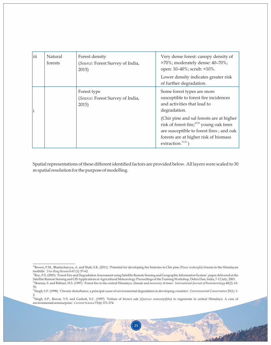
25
iii Natural
forests
Very dense forest: canopy density of
>70%; moderately dense: 40–70%;
open: 10–40%; scrub: <10%.
Lower density indicates greater risk
of further degradation.
Forest density
(Source: Forest Survey of India,
2015)
Some forest types are more
susceptible to forest fire incidences
and activities that lead to
degradation.
(Chir pine and sal forests are at higher 49,50risk of forest fire; young oak trees
are susceptible to forest fires ; and oak
forests are at higher risk of biomass 51,52extraction. )
Forest type
(Source: Forest Survey of India,
2015)
Spatial representations of these different identified factors are provided below. All layers were scaled to 30
m spatial resolution for the purpose of modelling.
49Brown, P.M., Bhattacharyya, A. and Shah, S.K. (2011). ‘Potential for developing fire histories in Chir pine (Pinus roxburghii) forests in the Himalayan foothills’. Tree-Ring Research 67 (1): 57-62.50Roy, P.S. (2003). ‘Forest Fire and Degradation Assessment using Satellite Remote Sensing and Geographic Information System’, paper delivered at the Satellite Remote Sensing and GIS Applications in Agricultural Meteorology Proceedings of the Training Workshop, Dehra Dun, India, 7-11 July, 2003.51Sharma, S. and Rikhari, H.S. (1997). ‘Forest fire in the central Himalaya: climate and recovery of trees’. International Journal of Biometeorology 40(2): 63-70.52Singh, S.P. (1998). ‘Chronic disturbance, a principal cause of environmental degradation in developing countries’. Environmental Conservation 25(1): 1-2.53Singh, S.P., Rawat, Y.S. and Garkoti, S.C. (1997). ‘Failure of brown oak (Quercus semecarpifolia) to regenerate in central Himalaya: A case of environmental semisurprise’. Current Science 73(4): 371-374.
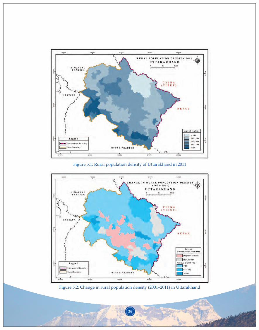
26
Figure 5.1: Rural population density of Uttarakhand in 2011
Figure 5.2: Change in rural population density (2001–2011) in Uttarakhand
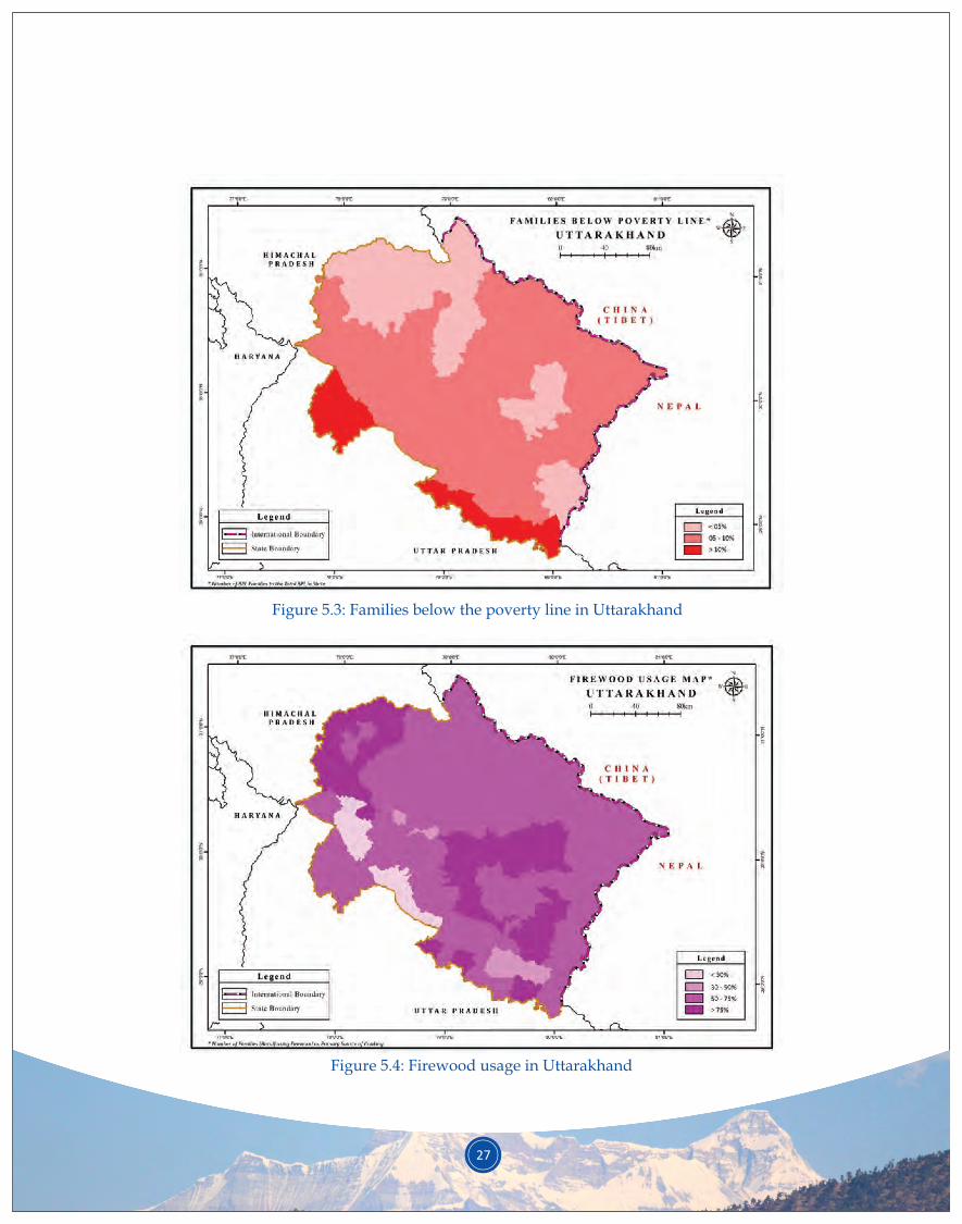
Figure 5.3: Families below the poverty line in Uttarakhand
Figure 5.4: Firewood usage in Uttarakhand
27
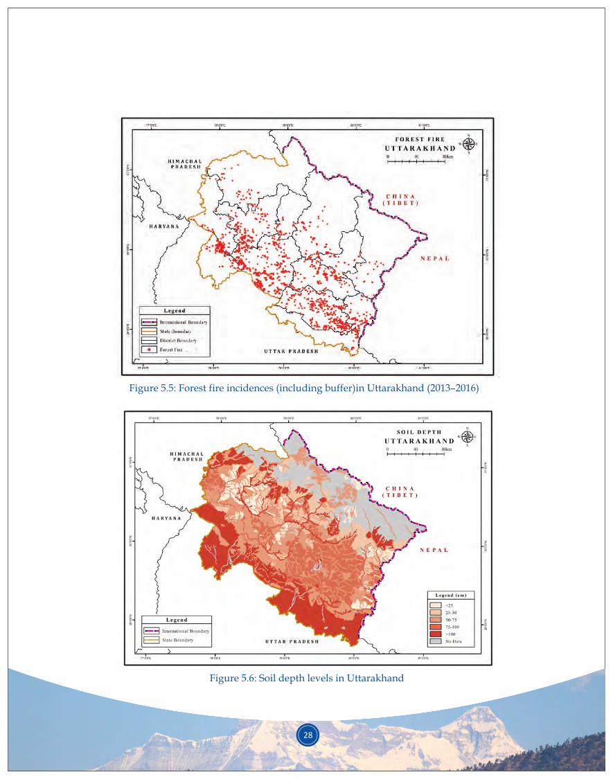
Figure 5.5: Forest fire incidences (including buffer)in Uttarakhand (2013–2016)
Figure 5.6: Soil depth levels in Uttarakhand
28
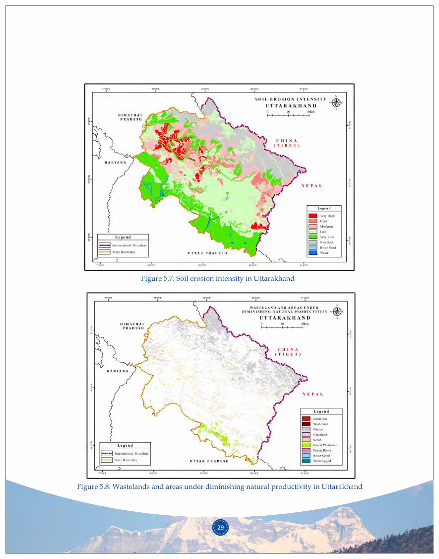
29
Figure 5.7: Soil erosion intensity in Uttarakhand
Figure 5.8: Wastelands and areas under diminishing natural productivity in Uttarakhand
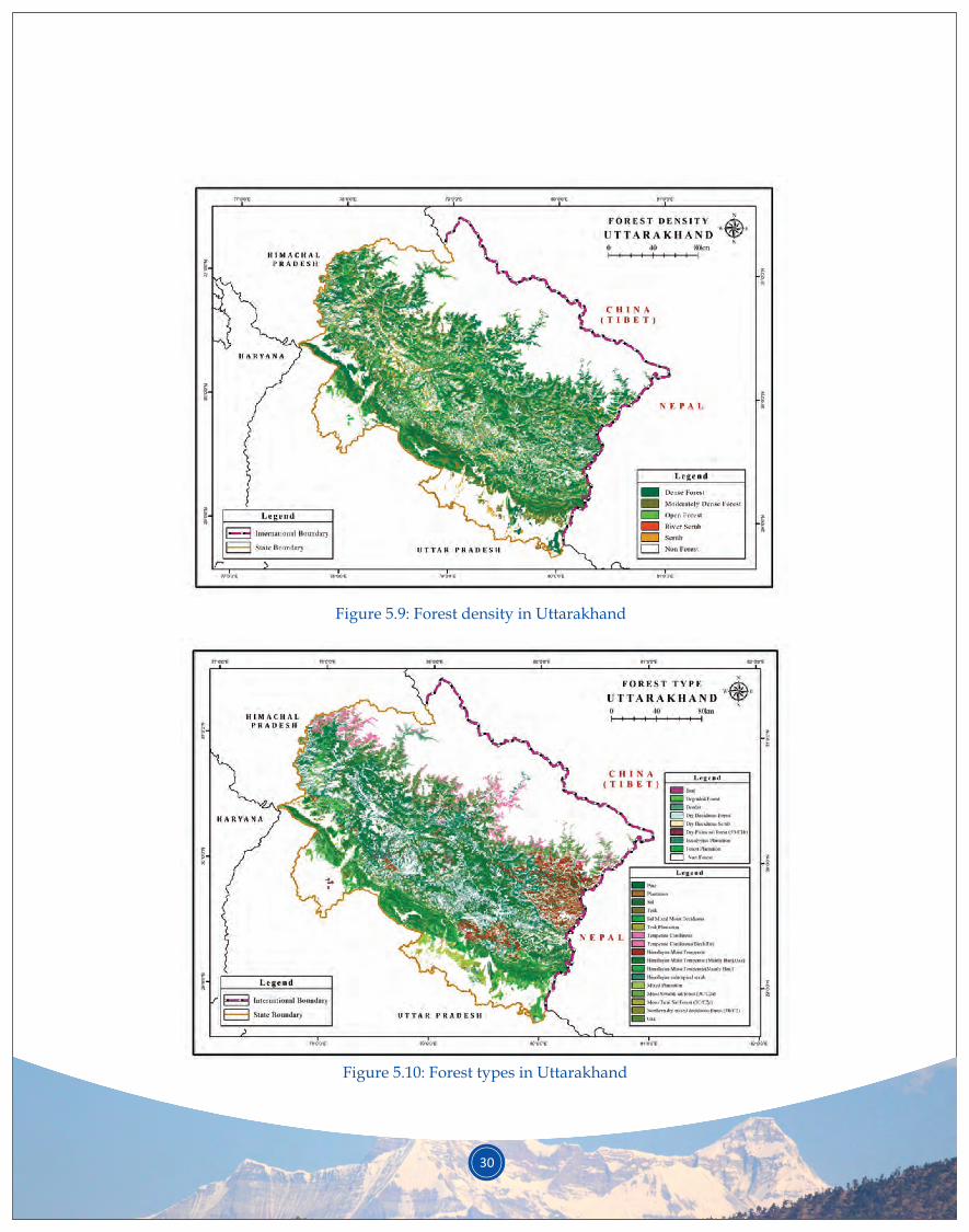
30
Figure 5.9: Forest density in Uttarakhand
Figure 5.10: Forest types in Uttarakhand

31
Figure 5.11: Functional degradation map of Uttarakhand
The various spatial layers (Figures 5.1 to 5.10, above) were used to generate a functional degradation map
of the state of Uttarakhand (Figure 5.11, below). Spatial analysis made the following exclusions: (i) areas
above 3,000 m asl were excluded from the study because the region is largely devoid of forests due to local
climatic conditions (timberline limit in this part of Himalayas) and minimal presence of permanent
settlements and (ii) urban centres, major dams and water reservoirs, etc. with no potential for restoration
opportunities under the FLR approach were also excluded from the study. These formed the exclusion
zones for the multi-criteria spatial analysis.
An overview of the state's functional degradation map is presented in Table 5.2,below.
Functional degradation categories
Elevation zones
< 1,000 m asl 1,000–2,000 m asl
Area (in ha)% Area (in
ha)% %
Very low
2.8
0.6 0.9 1.0
Low
27.0
10.6 11.7 11.9
Medium 43.5 35.4 30.2 26.7
High 15.6 35.8 40.3 21.0
Very high
5.4 16.2 16.4 8.8
Exclusion zones
5.7 1.4 0.5 30.6
38,9023,70,742
5,97,942
2,14,292
73,908
10,3371,85,7376,17,1826,24,4472,81,870
2,000–3,000 m aslArea (in ha)
6,54282,487
2,12,5072,83,6451,15,397
% area of the state
Table 5.2: Functional degradation areas in different strata of Uttarakhand

32
With the exclusion of the ‘low’ and ‘very low’ functional degradation areas and of exclusion zones, 56.5% of the state’s area falls in the functionally degraded category. While 21% of the state is facing high functional degradation, very high degradation is limited to 8.8% of the state’s geographical area. Due to interspersed human habitation all across Uttarakhand’s landscape (except high altitudes above 3,000 m asl) and a long history of dependency on and extraction from forests by rural communities, the forests of Uttarakhand have always been faced with high anthropogenic pressure. Intense pressure from commercial extractions, such as logging, have further exacerbated the situation.
Functional degradation maps for the two intensive sample sites are provided in Appendix 4.
Preparation of forest landscape restoration plans necessitates prior knowledge of FLR priority areas in the state. A restoration plan will not be feasible or practical unless one knows where to restore and what the priority areas may be. Very low and low priority areas can, for instance, be excluded from immediate restoration plans for the state. Mapping key priority areas is, thus, critical for prioritising interventions.
Identification of the levels of degradation (see functional degradation map, Figure 5.11) was the first input for developing spatial representation for priority mapping. To optimise appropriate restoration interventions to location-specific needs, other inputs were used to identify potential areas for restoration opportunities; inputs such as landuse/ land cover map of Uttarakhand and topographic influences (slope, aspect and elevation) helped in refining the suitability of interventions for specific locations. Among social considerations, usage of liquefied petroleum gas (LPG), an alternative to firewood, was considered; penetration of LPG in India has been found to reduce the usage of firewood and, thus, the pressure on
54forests. Table 5.3 provides a summary of the parameters used, and Figures 5.12 to 5.16 show the respective spatial layers.
Finally, the administrative divisions of Uttarakhand state (district level) were overlaid to ascertain the location and distribution of identified priority areas under different administrative jurisdictions.
5.2 FLR priority map
S.
No.
Consideration
factor
AssumptionsCorresponding data set input
1. Socio-cultural attributes
i Functional
degradation
Level of FLR priority increases with
an increase in the level of
degradation.
Functional degradation map
(Source: Map developed by the
current study [Figure 5.11])
ii Landuse Areas with current low productivity
(wastelands, barren land, forest
blanks, etc.) provide an opportunity
for restoration activities.
Urban built-up areas, major dams and
water reservoirs, which have no
potential for FLR, have been
excluded.
Landuse/ landcover
(Source: Prepared for this study
using Landsat images of year 2015)
54 Singh, D., Pachauri, S. and Zerriffi, H. (2017). ‘Environmental payoffs of LPG cooking in India’. Environmental Research Letters 12 (11): e115003. DOI:10.1088/1748-9326/aa909d.
Table 5.3: Summary of parameters used for developing multi-criteria FLR priority mapping
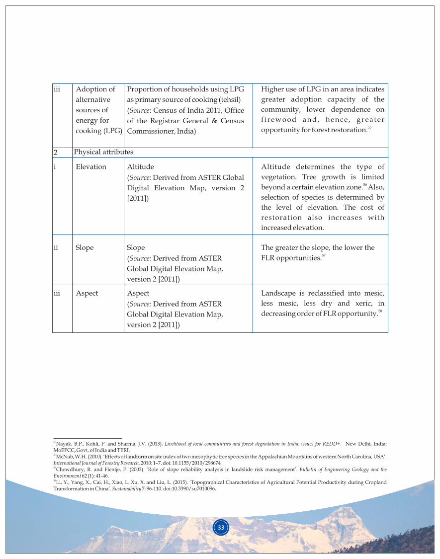
33
iii Adoption of
alternative
sources of
energy for
cooking (LPG)
Higher use of LPG in an area indicates
greater adoption capacity of the
community, lower dependence on
f i rewood and, hence , greater 55opportunity for forest restoration.
Proportion of households using LPG
as primary source of cooking (tehsil)
(Source: Census of India 2011, Office
of the Registrar General & Census
Commissioner, India)
Elevation Altitude determines the type of
vegetation. Tree growth is limited 56 beyond a certain elevation zone. Also,
selection of species is determined by
the level of elevation. The cost of
restoration also increases with
increased elevation.
Altitude
(Source: Derived from ASTER Global
Digital Elevation Map, version 2
[2011])
2 Physical attributes
Slope
Aspect
The greater the slope, the lower the 57FLR opportunities.
Slope
(Source: Derived from ASTER
Global Digital Elevation Map,
version 2 [2011])
ii
iii Landscape is reclassified into mesic,
less mesic, less dry and xeric, in 58decreasing order of FLR opportunity.
Aspect
(Source: Derived from ASTER
Global Digital Elevation Map,
version 2 [2011])
55Nayak, B.P., Kohli, P. and Sharma, J.V. (2013). Livelihood of local communities and forest degradation in India: issues for REDD+. New Delhi, India: MoEFCC, Govt. of India and TERI. 56McNab, W.H. (2010). ‘Effects of landform on site index of two mesophytic tree species in the Appalachian Mountains of western North Carolina, USA’. International Journal of Forestry Research. 2010: 1–7. doi: 10.1155/2010/29867457Chowdhury, R. and Flentje, P. (2003). ‘Role of slope reliability analysis in landslide risk management’. Bulletin of Engineering Geology and the Environment 62 (1): 41-46.58Li, Y., Yang, X., Cai, H., Xiao, L. Xu, X. and Liu, L. (2015). ‘Topographical Characteristics of Agricultural Potential Productivity during Cropland Transformation in China’. Sustainability 7: 96-110. doi:10.3390/su7010096.
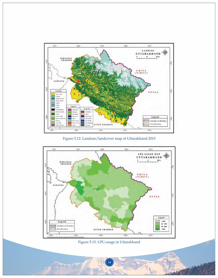
34
Figure 5.12: Landuse/landcover map of Uttarakhand 2015
Figure 5.13: LPG usage in Uttarakhand
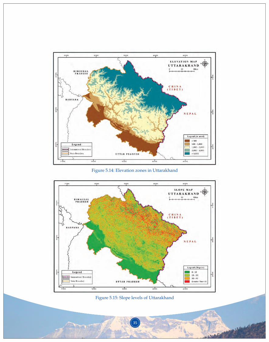
Figure 5.14: Elevation zones in Uttarakhand
Figure 5.15: Slope levels of Uttarakhand
35
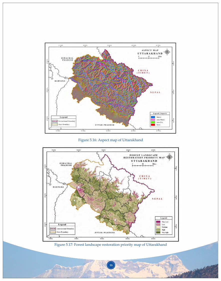
36
Figure 5.16: Aspect map of Uttarakhand
Figure 5.17: Forest landscape restoration priority map of Uttarakhand
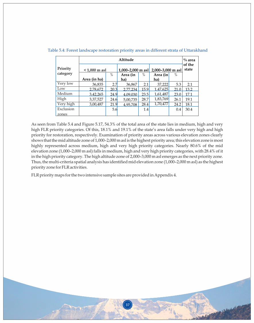
37
Priority
category
Very low
Low
Medium
High
Very high
Exclusion
zones
Altitude
< 1,000 m asl 1,000–2,000 m asl
Area (in ha)% Area (in
ha)% %
36,835
2,78,672
3,42,265
3,37,527
3,00,487
36,867
2,77,234
4,09,030
5,00,735
4,95,708
2,000–3,000 m aslArea (in ha)
37,2221,47,6251,61,4871,83,7691,70,477
% area of the state
Table 5.4: Forest landscape restoration priority areas in different strata of Uttarakhand
2.7
20.3
24.9
24.6
21.9
5.6
2.1
15.9
23.5
28.7
28.4
1.4
5.3
21.0
23.0
26.1
24.2
0.4
2.1
13.2
17.1
19.1
18.1
30.4
As seen from Table 5.4 and Figure 5.17, 54.3% of the total area of the state lies in medium, high and very
high FLR priority categories. Of this, 18.1% and 19.1% of the state’s area falls under very high and high
priority for restoration, respectively. Examination of priority areas across various elevation zones clearly
shows that the mid altitude zone of 1,000–2,000 m asl is the highest priority area; this elevation zone is most
highly represented across medium, high and very high priority categories. Nearly 80.6% of the mid
elevation zone (1,000–2,000 m asl) falls in medium, high and very high priority categories, with 28.4% of it
in the high priority category. The high altitude zone of 2,000–3,000 m asl emerges as the next priority zone.
Thus, the multi-criteria spatial analysis has identified mid elevation zone (1,000–2,000 m asl) as the highest
priority zone for FLR activities.
FLR priority maps for the two intensive sample sites are provided in Appendix 4.
Based on the findings of the assessment, proposed restoration interventions were formulated for each
altitudinal zone. The suggested interventions were based on the following: (i) priorities identified in
stakeholder consultations, (ii) review of available literature and (iii) the available knowledge base and field
interactions of the assessment team. Restoration strategies for each altitudinal zone are detailed below.
A. Landscape characteristics and issues
The high altitude region of Uttarakhand is characterised by high tectonic activity, sloping land, frequent
landslides, intense precipitation, cloudburst, glacial lake outburst floods, degradation of forested
landscape and recurrent loss of life and property. This region is rich in forests and biodiversity, MAPs,
alpine meadows and sacred natural sites (lakes, landscapes, mountain peaks, etc.) and has a rich tradition
of community-based conservation of forests and other natural resources. Recognising the potential of
MAPs in Uttarakhand, the state government has already declared it a ‘herbal state’.
Communities residing in the high altitude zone mainly depend on alpine pastures and forested landscape
for seasonal grazing of their livestock, collection of wild MAPs and seasonal cultivation of food crops to
sustain their livelihoods. Due to various natural disasters and degradation of landscape, and prompted by
the search for alternate livelihood opportunities, rampant out-migration has taken place from high-
altitude villages. This has resulted in abandonment of crop land and even houses at times, increasing the
number of depopulated villages.
B. Specific strategies
• There should be documentation of disaster prone areas and establishment of an inter-departmental
disaster management mechanism, especially in districts under the jurisdiction of the District
Magistrate. This will enhance information sharing of collected data (e.g.maps/location of disaster
prone areas) and each department’s plan for disaster preparedness, mitigation and adaptation.
Rapid Visual Screening (RVS) is a cost effective tool for identifying highly vulnerable structures 59that can subsequently be surveyed in detail for appropriate mitigation measures.
6.1 High altitude (2,000–3,000 m asl)
1) Disaster management
6. RESTORATION STRATEGY - PRIORITIES AND INTERVENTIONS BY STRATA
38
59Rautela, P., Joshi, G.C. and Bhaisora, B. (2011). ‘Seismic vulnerability of the health infrastructure in the Himalayan township of Mussoorie, Uttarakhand, India’. International Journal of Disaster Resilience in the Built Environment 2 (3), 200-209.
39
• Bio-engineering measures should be implemented to control flash floods, soil erosion and small-
scale hillslope instabilities. This approach is also known as mountain risk engineering (MRE). It
uses a combination of grass, shrub and tree species suited to local ecological conditions (such as
Chrysopogon spp., Hippophae salicifolia, Arundinaria falcata, Alnus nepalensis, etc.), either by
themselves or in combination with civil engineering structures (such as modification of slope
geometry, riprap drainage, gabion check dam/toe wall, filling of cracks and retaining structures,
and internal slope reinforcement). In case of vegetative measures, basic techniques of brush
layering, jute netting, contour/diagonal grass plantation and live check dams/pegs can be
adopted (see Box 6.1). This technology is less expensive, more effective and more adaptable over
the long term. The plants stabilise the soil through root anchorage and also provide other benefits
to people.
• Training of locals on disaster preparedness and mitigation and mapping of disaster prone areas is
also required. The Disaster Mitigation and Management Centre (DMMC) unit in Uttarakhand
should continue to lead this, supported by other relevant line agencies, local NGOs and research
institutes.
Box 6.1: Stabilisation of slope instabilities and landslides through mountain risk engineering
Improved engineering and bio-engineering technology has been devised by GBPNIHESD to
reduce soil erosion and control landslides. This technology uses suitable plants, individually or in
conjunction with civil engineering structures, to reduce slope instability and erosion.
Interventions such as modification of slope geometry, riprap drainage, gabion check dam/toe
walls, reinforcement of retaining structures and internal slopes with local flora are cost-efficient,
long-term stabilisation methods. Brush layering, jute netting, contour/diagonal grass plantation
and live check dams/pegs can be adopted as biological stabilisation measures. Jute netting is a
useful way of stabilising steep slopes (35–80°) where it is difficult to establish vegetation.
The approach was piloted by GBPNIHESD in two villages in Almora district, Uttarakhand. Based
on local climatic and physiographic conditions, various local plants with strong roots were used to
provide both soil stabilisation benefits and fodder to the local people. The pilot sites served as
practical demonstration sites for biological landslide control.
Cost estimates for various engineering and bioengineering structures indicate that bioengineering
techniques, used in combination with civil and social engineering measures, can reduce the overall
cost of landslide mitigation considerably, almost by 12%.
40
2) Promotion of sacred groves/spiritual forests
3) Promotion of livelihood options
Sacred groves/spiritual forests are an old tradition in the region. Sacred sites are segments of landscape,
containing vegetation, other forms of life and geographical features, that are protected by human societies
under cultural and religious beliefs that prohibit intervention. The community-imposed ban on these sites
keeps them relatively undisturbed. Sacred groves, thus, play a major role in environmental protection and
can be considered community-based monuments of biological and cultural diversity. They have an
important role in protecting natural water sources, harbouring plants of ethno-botanical importance and
serving as gene banks. Communities prohibit anyone from cutting trees, extracting dry leaves and, in
some cases, even entering sacred areas. The sacred groves conserved and protected by local communities
are a prime example of community participation in biodiversity conservation. Uttarakhand has a plethora
of sacred natural sites, including mountain peaks, lakes, forests, groves and meadows. The Pithoragarh
district alone has 132 such sacred sites, including 77 sacred groves, 27 sacred forests (areas larger than 2 ha
each), 18 wetlands and 10 pastures.
Recent times have seen an increasing trend of communities dedicating degraded forested landscapes
(usually under van panchayats) to a particular deity, thus creating new sacred sites/groves. The
community places a ban on grazing, harvesting, etc. from the site for a stipulated duration, thus relieving
anthropogenic pressure and allowing the site to regenerate naturally. At the end of the stipulated
duration, the condition of the site is evaluated and based on that the ban is either lifted or continued. This
practice can be promoted in highly degraded sites as a potential conservation tool. Specific
recommendations to this end include the following:
• Emphasis must be placed on documenting the process, key players, results and potential
incentives in order to improve the mechanisms through which communities create new sacred
sites in the landscape.
• Case studies on sacred sites that communities have dedicated to local deities for a particular
duration should be documented and data collected on the effect of the community-imposed ban on
site regeneration. This could encourage other communities to also adopt this practice.
• Scale up of such practices must be encouraged across the state.
• Cultivation of medicinal and aromatic plants
Incentive-based cultivation of MAPs and NTFPs on abandoned cropland, sacred sites and
community forests should be promoted through contract farming, introduction of agro-
techniques, providing facilities for post-harvest and storage, facilitating marketing networks and
capacity building of local communities. This approach has the potential to minimise out-
migration, a recognised consequence of landscape degradation.
Local communities currently favour cultivation of MAPs over traditional cereal crops, given the
MAPs’ relatively short growing cycle, long shelf-life and high demand by pharmaceutical
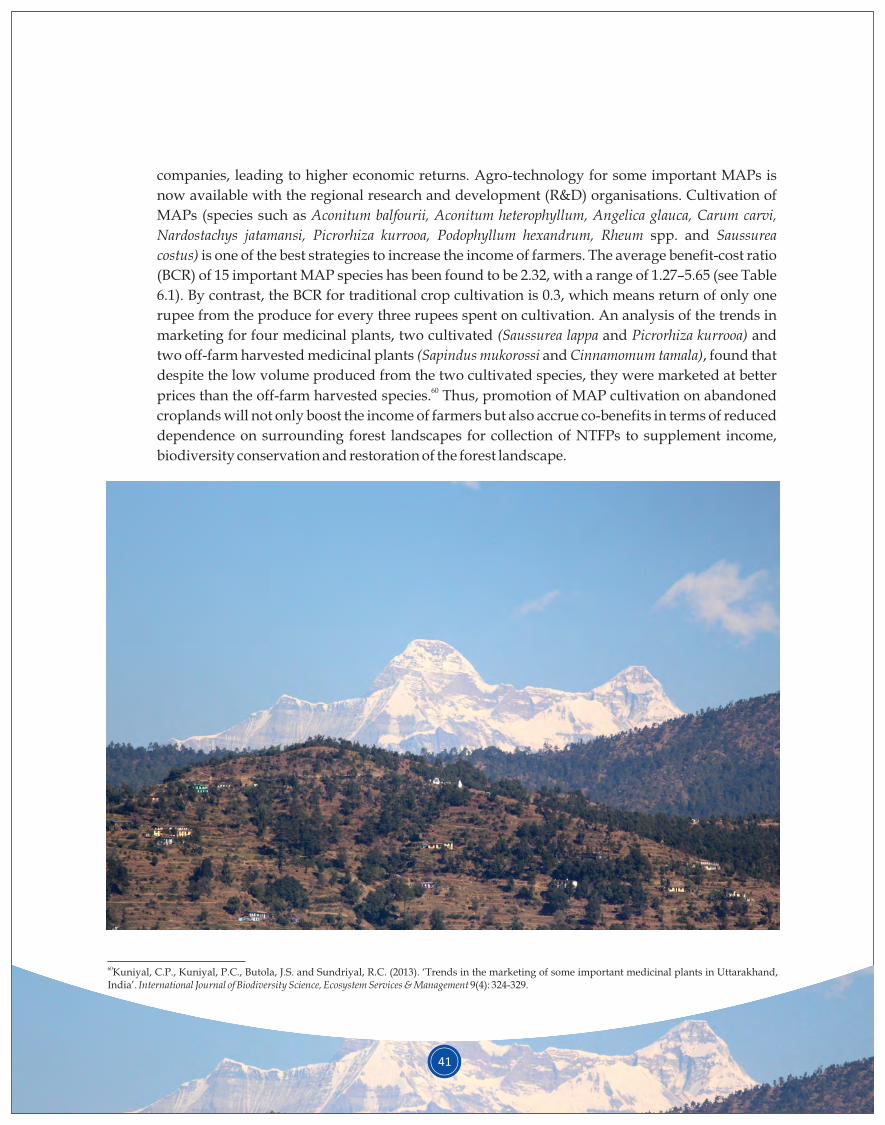
41
companies, leading to higher economic returns. Agro-technology for some important MAPs is
now available with the regional research and development (R&D) organisations. Cultivation of
MAPs (species such as Aconitum balfourii, Aconitum heterophyllum, Angelica glauca, Carum carvi,
Nardostachys jatamansi, Picrorhiza kurrooa, Podophyllum hexandrum, Rheum spp. and Saussurea
costus) is one of the best strategies to increase the income of farmers. The average benefit-cost ratio
(BCR) of 15 important MAP species has been found to be 2.32, with a range of 1.27–5.65 (see Table
6.1). By contrast, the BCR for traditional crop cultivation is 0.3, which means return of only one
rupee from the produce for every three rupees spent on cultivation. An analysis of the trends in
marketing for four medicinal plants, two cultivated (Saussurea lappa and Picrorhiza kurrooa) and
two off-farm harvested medicinal plants (Sapindus mukorossi and Cinnamomum tamala), found that
despite the low volume produced from the two cultivated species, they were marketed at better 60prices than the off-farm harvested species. Thus, promotion of MAP cultivation on abandoned
croplands will not only boost the income of farmers but also accrue co-benefits in terms of reduced
dependence on surrounding forest landscapes for collection of NTFPs to supplement income,
biodiversity conservation and restoration of the forest landscape.
60Kuniyal, C.P., Kuniyal, P.C., Butola, J.S. and Sundriyal, R.C. (2013). ‘Trends in the marketing of some important medicinal plants in Uttarakhand, India’. International Journal of Biodiversity Science, Ecosystem Services & Management 9(4): 324-329.
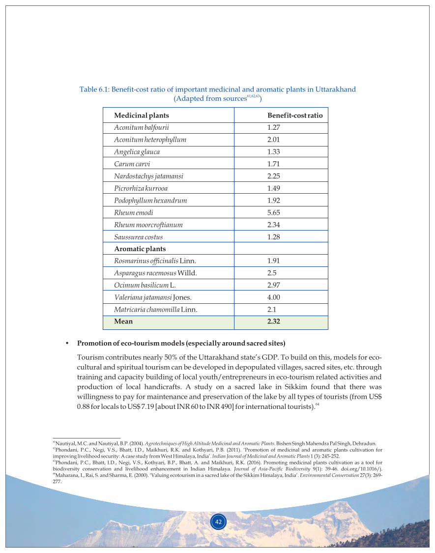
42
Table 6.1: Benefit-cost ratio of important medicinal and aromatic plants in Uttarakhand61,62,63(Adapted from sources )
Medicinal plants Benefit-cost ratio
Aconitum balfourii 1.27
Aconitum heterophyllum 2.01
Angelica glauca 1.33
Carum carvi 1.71
Nardostachys jatamansi 2.25
Picrorhiza kurrooa 1.49
Podophyllum hexandrum 1.92
Rheum emodi 5.65
Rheum moorcroftianum 2.34
Saussurea costus 1.28
Aromatic plants
Rosmarinus officinalis Linn. 1.91
Asparagus racemosus Willd. 2.5
Ocimum basilicum L. 2.97
Valeriana jatamansi Jones. 4.00
Matricaria chamomilla Linn. 2.1
Mean 2.32
• Promotion of eco-tourism models (especially around sacred sites)
Tourism contributes nearly 50% of the Uttarakhand state’s GDP. To build on this, models for eco-
cultural and spiritual tourism can be developed in depopulated villages, sacred sites, etc. through
training and capacity building of local youth/entrepreneurs in eco-tourism related activities and
production of local handicrafts. A study on a sacred lake in Sikkim found that there was
willingness to pay for maintenance and preservation of the lake by all types of tourists (from US$ 640.88 for locals to US$ 7.19 [about INR 60 to INR 490] for international tourists).
61Nautiyal, M.C. and Nautiyal, B.P. (2004). Agrotechniques of High Altitude Medicinal and Aromatic Plants. Bishen Singh Mahendra Pal Singh, Dehradun.62Phondani, P.C., Negi, V.S., Bhatt, I.D., Maikhuri, R.K. and Kothyari, P.B. (2011). ‘Promotion of medicinal and aromatic plants cultivation for improving livelihood security: A case study from West Himalaya, India’. Indian Journal of Medicinal and Aromatic Plants 1 (3): 245-252.63Phondani, P.C., Bhatt, I.D., Negi, V.S., Kothyari, B.P., Bhatt, A. and Maikhuri, R.K. (2016). Promoting medicinal plants cultivation as a tool for biodiversity conservation and livelihood enhancement in Indian Himalaya. Journal of Asia-Pacific Biodiversity 9(1): 39-46. doi.org/10.1016/j. 64Maharana, I., Rai, S. and Sharma, E. (2000). ‘Valuing ecotourism in a sacred lake of the Sikkim Himalaya, India’. Environmental Conservation 27(3): 269-277.

43
Maati in Munsiyari, Uttarakhand, offers an example. Maati is a women's organisation that began with
providing local women a source of additional income by promoting entrepreneurship skills and
marketing of traditionally made woollen products. The organisation has now expanded into providing
homestays for tourists, and the women have also been trained to serve as tourist guides in the area. This
has helped develop within communities a sense of pride for their forests and recognition of the value of
natural resource conservation. Eco-tourism activities such as trekking, camping, bird watching and
mountain biking are already becoming popular in the region (see Box 6.2).
Box 6.2: Maati – A model for promoting alternative livelihoods in rural Uttarakhand
Maati is an autonomous women's organisation located in Sarmoli village, Munsiyari,
Uttarakhand. It was established to provide an alternate source of income to village women by
teaching them entrepreneurial and marketing skills for traditionally made woollen products, an
answer to their disadvantaged financial situation. Maati now functions as a joint initiative with
Himal Prakriti, a trust focused on different environmental issues in the Himalayan region, and
contributes to the education of local children through an informal gathering, called Jungli School,
and operation of Prakriti Kendra, a resource centre. The success of this initiative is apparent from
the number of homestays that have come up to offer traditional food and housing to visiting
tourists.
Apart from homestays, Himalayan Ark, a company focused on providing the locals a secondary
source of income, is known to conduct trekking expeditions in and around Munsiyari. The trained
village women work as tourist guides besides running their homestays. They have developed a
sense of pride for their forests and appreciation for their value as sustainable sources of income.
Maati’s model combats social, political and environmental issues while creating sustainable
alternative income sources for local people.
6.2 Mid altitude (1,000–2,000 m asl)
A. Landscape characteristics and issues
The mid altitude zone of Uttarakhand is primarily a forest-dominated area with intermixed areas of rain-
fed agriculture; a large part of the forested area is under community forests. Traditional practices of
community forestry (van panchayats) and agroforestry are prevalent in the region. The landscape is,
however, experiencing increasing abandonment of agricultural fields, soil erosion, explosion of urban
centres and chronic forest degradation through continued, unsustainable harvesting of forest resources.
Expansion of chir pine forests is also characteristic of this zone.
Water scarcity, forest fires, out-migration and increasing human-wildlife conflicts are among the region’s
major issues.
44
B. Specific strategies
The state of Uttarakhand has a history of forest fires, and recent decades have witnessed an increase in the
frequency of fire incidences, often attributed to reduced rainfall and increased temperature in summer
months coinciding with leaf fall period for the major forest tree species of the region. Expansion of chir
pine forests is often held responsible for the increasing intensity and frequency of forests fires. Chir pine
species thrive in open, relatively dry lands and are expanding due to the increasing openings that over
harvesting for fodder and fuel needs has caused in the canopy of broad-leaf forests. Notably, chir pine is
also spreading to abandoned agricultural lands. Therefore, appropriate interventions at government and
community level are needed, especially to address the issue of increasing abandonment of agricultural
areas; promotion of contractual farming is a possible intervention.
The state has already mapped forest fire risk zone (FFRZ). It was found that approximately 3.13% of the 65total forested area was in very high-risk zone and 50.25% area was in high-risk zone.
Intensity and frequency of forest fires can be reduced through the following interventions at the local
level:
• Introduction and protection of broad-leaf and NTFP plantations in areas occupied by chir pine
could be a vital intervention. Kaifal (Myrica esculenta) and Amla (Emblica officinalis) plantations
can, for example, be initially promoted in community-owned forests.
• Communities must be motivated and engaged in forest fire control, particularly in community
forest areas. Capacity building of communities for fire control is important. Community forest
groups and informed villagers/ citizens are important for preparedness and management of
forest fire (during the event) to conserve the valuable forest wealth of the region. Use of mobile
phone applications as early warning systems could help synergise efforts (see Box 6.3).
• Pilot schemes promoting use of pine needles for various economic activities, such as bio-
briquetting, gasifiers and papermaking, should be scaled up. A project on pine-briquetting in
Uttarakhand demonstrated that rural households who shifted from fuelwood to pine briquettes 66reduced their fuelwood needs by 1.1 MT per year per household. The participating group
members earned INR 15.97 lakh from the sale of pine-briquettes over the project's 4-year duration
(see Box 6.4).
1) Forest fire management
65Thakur, A.K. and Singh, D. (2014). ‘Forest Fire Risk Zonation Using Geospatial Techniques and Analytic Hierarchy Process in Dehradun District, Uttarakhand, India’. Universal Journal of Environmental Research and Technology 4(2): 82-89.66Pandey, J.C., Gangwar, P., Kumar, N. and Grewal, N. (2014). ‘Pine Briquetting- An Endeavour for Green Fuel’. Indian Forester 140(5): 478-482
45
Box 6.3: Role of community and mobile phone applications to analyse degradation due to forest
fires
The Himalayan landscape has the potential to dovetail social values into forest management. The
existing management structure of community forests (~12,000 forest councils in the state) may
viably function through incentive-based mechanisms, combining the forest council and forest
department resources to better operate during active fire seasons.
A large ground-based network of people (village councils) and attentive villagers in remote
localities can utilise their mobile phones to provide crucial data to the centrally located ‘Fire
Information and Control System’ of the state. The use of modern techniques (ground to sky) is key
to better combatting forest fires and reducing their adverse social, economic and ecological
consequences. Community forest councils and alert citizens can aid in the overall preparedness to
address (fire potential index) and manage forest fires (while in progress) to combat the overall
forest loss in the Himalaya.
Box 6.4: Efforts to use chir pine needles by a regional NGO – Avani case study
Avani Bio Energy, an organisation based at Berinag, district Pithoragarh, has been successfully
using chir pine needles in gasifiers to produce electricity since 2009. In 2014, they put up a 100 kW-
capacity plant in the Chachreda village of Pithoragarh, with a 20-year agreement with
Uttarakhand Power Corporation Limited (UPCL), Government of Uttarakhand. When run for 24
hours, this gasifier requires 4,500 kg of pine needles.It can use 1,350 tonne pine needles annually to
produce 10,800 kW electricity per year. The residue in the gasifier is used to make smokeless
cooking charcoal and is sufficient for the fuelwood needs of 100 households.
Local women collect the pine needles and sell it to Avani. Some difficulties in pine needle
collection, such as distant location of pine forests on steep slopes, and the moisture content of pine
needles need to be overcome to make this venture profitable. This small-scale venture needs to be
promoted and scaled up across the state of Uttarakhand to reduce the menace of forest fires while
also reducing anthropogenic pressure on forests for firewood and promoting and enhancing
livelihood opportunities for local communities.
46
2) Promotion of community forestry through van panchayats
3) Promotion of silvi-pastoral systems
Uttarakhand has 12,089 van panchayats (community forest councils) that manage about 16% of the state’s
forest area. Pithoragarh district alone has approximately 1,64,067 ha area under van panchayats, which
are distributed across all altitude zones. However, the mid altitude zone has the maximum density of van
panchayats (number: 1,370; area: 39,155 ha). Most van panchayats cover mature forests. Taking the -1 -1 -1 -1average carbon sequestration rates of 2.5 t ha yr – plantations (0.9 t ha yr ) and mature forests (2.64–3.96
-1 -1t ha yr ) – the forests under van panchayat management sequester approximately 1.8 million tonne
carbon annually (Garhwal district: 0.12 million tonne and Pithoragarh district: 0.20 million tonne carbon
annually).
Despite the presence of such a strong and established institution for community forests and its proven
contribution towards livelihood promotion and environmental conservation in the state, most of these
forests are now faced with growing community ignorance and apathy towards their management. The
quality of community forests is, thus, degrading and in need of immediate attention. Developing
incentive-based mechanisms to combat people's growing apathy towards forest management is one
possible solution. It can be achieved by empowering van panchayats and redefining their possible role in
restoration. Specific strategies towards this aim include the following:
• Van panchayats can be empowered through skill building and knowledge sharing. Possibility of
tapping into voluntary carbon markets can be explored/developed. Pilot implementation of
community forest-based carbon mitigation projects (REDD+ schemes) can be attempted initially.
• Van panchayats must be linked with opportunities for enhanced livelihood options, for example,
through introduction of MAPs and other NTFPs in community forests, marketing avenues for
wild edibles and development of nature-based tourism. Some MAPs suitable for the mid altitude 67zone are Kuth (Saussurea costus), Tagar (Valeriana jatamansi), Van Haldi (Hedychium spicatum) and
68Chamomile (Matricaria chamomilla).
• Natural regeneration of forests under van panchayats can be accelerated by engaging people in
fire protection and reducing forest degradation by dedicating degraded sites to local deities (see
sacred forest promotion under Section 6.1).
The state has a major deficit of fodder, with emerging livestock patterns such as increasing interest in high-
yielding breeds of cow and goats, causing changes in fodder demand. The deficit of fodder can be tackled
by bringing degraded lands and rangelands under need-based plantation of high quality grass and tree
fodder species. It can be achieved through promotion of silvi-pasture system on highly degraded forests
and rangelands owned by communities, government or private individuals. This intervention will have
67Rawat, S., Jugran, A.K., Bhatt, I.D., Rawal, R.S. (2018). ‘Hedychium spicatum: a systematic review on traditional uses, phytochemistry, pharmacology and future prospects’. Journal of Pharmacy and Pharmacology 70(3): doi:10.1111/jphp.12890.68The Energy and Resources Institute (2013). Identification of Medicinal and Aromatic Plants Suitable for Cultivation and Inclusion in Afforestation and Income Generation Programmes for the State of Uttarakhand. Submitted to State Medicinal Plants Board (SMPB), Uttarakhand. Dehradun: TERI.
47
multiple benefits: (i) catering to fodder needs for livestock, (ii) helping in reduction of open grazing, (iii)
restoring soil fertility, and (iv) achieving soil and water conservation. While considering species for
plantation, priority must be given to native plant species such as Apluda mutica, Chrysopogon
fulvus,Trifolium alexandrium, Styloxanthus hamata, and Cenchrus ciliaris (fodder species); and Grewia optiva,
Boehmeria rugulosa, and Ficus nemoralis (fodder trees) for their high quality and acceptance in the
community. Also, species combinations must be designed to ensure round-the-year supply of fodder.
Nurseries with appropriate planting species should, therefore, be established in different areas.
Experimental interventions have shown that planting such grasses can enhance the fodder productivity of 69wastelands by up to eight times. Examination of the cumulative effects of grass plantation and soil and
water conservation measures found that soil fertility (30 cm depth) of these sites was raised substantially –
soil carbon increased from 0.44% to 0.96%, organic matter from 0.75% to 1.66%, and soil moisture from
13.2% to 20%. Additionally, it reduced the drudgery of local women who are usually responsible for
collection of fodder and fuelwood. In India, carbon sequestration potential of agroforestry systems is 70estimated between 0.25–19.14 and 0.01–0.60 Mg C/ha/yr for tree and crop component, respectively.
Water scarcity emerged as one of the most pressing issues during consultations with various stakeholder
groups at all levels (state, districts and representative blocks). Natural springs are the major source of
domestic and agricultural water for most communities in the landscape. However, due to several reasons,
such as changes in land-use patterns, forest degradation, changing climate and various other natural and
anthropogenic disturbances, the existence of these natural water sources has been severely compromised. 71A scientific report from nearly three decades back had indicated that almost 75% of the springs in the
Kumaon region of Uttarakhand had gone dry, with an average decline of ~40% in the discharge of springs
from 1951 to 1986. The report attributed this significant decline in spring discharge to changes in land-use
patterns and vegetation. Two recent pilot studies in representative watersheds in Pithoragarh district
revealed that a high percentage (37–40%) of the villages in the landscape are experiencing water scarcity
(i.e., high demand and low availability of water). Groundwater sources and villages located in the mid-hill
region are more vulnerable, owing to geomorphic and physiographic features and greater intensity of
anthropogenic and natural changes. However, there are some favourable factors: (i) geo-hydrological
studies suggest that geological structures and rock formations in this zone are favourable to groundwater
resources, thereby augmenting recharge and (ii) the community in general is willing to participate in
spring rejuvenation activities.
Realising the value natural springs hold for addressing water scarcity in the region, an ecosystem-based
approach must be adopted for recharging natural springs. The springshed management approach, which
enhances the quantity of run-off rainwater being directed into the spring recharge zone through
4) Interventions for rejuvenation of water sources
69Negi, G.C.S., Rawal, R.S. and Dhyani, P.P. (2015). 25 Glorious Years of GBPIHED: Translating Research into Action. Almora, Uttarakhand: GBPIHED.70Sirvi, A., Dhyani, S. and Dev, I. (2016). ‘Potential of agroforestry systems in carbon sequestration in India’. Indian Journal of Agricultural Sciences 86: 1103-1112.71Valdiya, K.S. and Bartarya, S.K. (1989). ‘Diminishing discharge of mountain springs in a part of Kumaun Himalaya’. Current Science 58: 417–426.
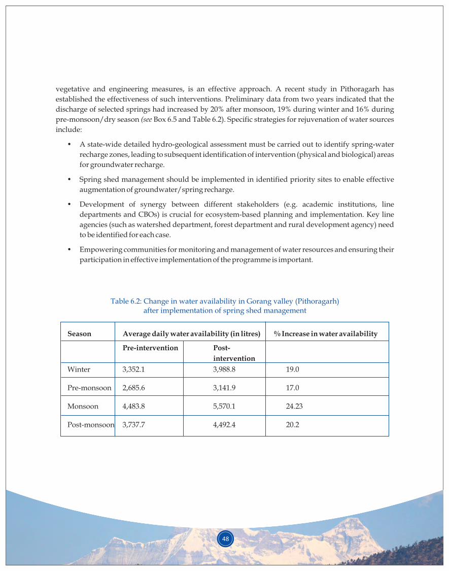
48
vegetative and engineering measures, is an effective approach. A recent study in Pithoragarh has
established the effectiveness of such interventions. Preliminary data from two years indicated that the
discharge of selected springs had increased by 20% after monsoon, 19% during winter and 16% during
pre-monsoon/dry season (see Box 6.5 and Table 6.2). Specific strategies for rejuvenation of water sources
include:
• A state-wide detailed hydro-geological assessment must be carried out to identify spring-water
recharge zones, leading to subsequent identification of intervention (physical and biological) areas
for groundwater recharge.
• Spring shed management should be implemented in identified priority sites to enable effective
augmentation of groundwater/spring recharge.
• Development of synergy between different stakeholders (e.g. academic institutions, line
departments and CBOs) is crucial for ecosystem-based planning and implementation. Key line
agencies (such as watershed department, forest department and rural development agency) need
to be identified for each case.
• Empowering communities for monitoring and management of water resources and ensuring their
participation in effective implementation of the programme is important.
Table 6.2: Change in water availability in Gorang valley (Pithoragarh) after implementation of spring shed management
Season Average daily water availability (in litres) % Increase in water availability
Pre-intervention Post-
intervention
Winter 3,352.1 3,988.8 19.0
Pre-monsoon 2,685.6 3,141.9 17.0
Monsoon 4,483.8 5,570.1 24.23
Post-monsoon 3,737.7 4,492.4 20.2
49
Box 6.5: Springshed management as an ecosystem service and restoration option
Spring shed management seeks to enhance percolation of rainwater into the spring recharge zone
through both engineering and vegetative measures, resulting in augmented discharge to the
springs downstream. In an R&D demonstration in Garhwal (Pauri) district by GBPNIHESD, 18.5
ha of a dry spring were treated with various engineering, vegetative and social measures, costing
INR 10,050 per ha. Following the implementation of these measures, spring discharge increased to
6.8% of the annual rainfall. The increase of spring discharge during summer was found to be 3.7
times greater – up from 595 L/d in June 1995 to 2,170 L/d in June 1998.
Another similar demonstration by GBPNIHESD, undertaken in collaboration with the
Uttarakhand Forest Department and Gorang valley communities (Pithoragarh), involved novel
soil and water conservation techniques, planting Quercus leucotrichophora and Q. glauca on 1 ha of
van panchayat land. Preliminary observations indicated a 17–24%increase (varying by season) in
the availability of water in select springs. Additional long-term benefits of these interventions are
evident in the increased availability of fuel and fodder for livestock along with improved natural
regeneration and regional biodiversity. A key social benefit spring shed management brings is
reduction in the time women have to spend collecting water in the dry season.
In Pithoragarh district, a total of 1,510 soil and water conservation measures were implemented in
2009–2017 at an investment of INR 1431.4 lakh. Based on findings of earlier studies, the soil erosion
and nutrient loss trapped by these soil and water conservation measures were calculated.
Estimates indicate that through these activities undertaken by line agencies, nearly 80.14x10³
cubic meter water was stored and 1,36,240 tonnes of soil containing 272.48 kg of nitrogen and
1362.4 kg of organic carbon was conserved. Similarly, 17.83x10⁴ cubic meter water was conserved
through the construction of 2,254 check dams, built at an investment of INR 2,568 lakh. Another
similar effort has been the development of a total of 6,701 irrigation facilities (irrigation tanks,
gullies, canals, etc.) through an investment of INR 8,376 lakh, irrigating an area of 7,529 ha.
6.3 Low altitude (< 1,000 m asl)
1) Cash-crop based agriculture, horticulture and floriculture
A. Landscape characteristics and issues
Valleys, moderately sloping regions and flatlands in river plains characterise the low altitude zone. The
main livelihood activities here include modern cash-crop based agriculture due to the availability of
irrigation facilities, agroforestry and livestock farming. This region is also characterised by urbanisation
and secondary and tertiary economic activities. Frequent forest disturbances, forest fires, invasion of
forests by weeds such as Lantana and Eupatorium spp., and human-wildlife conflict (especially crop
raiding) are common in this region. The community has high dependence on forests for a variety of
resources, and landuse and land cover change due to urbanisation and population growth are
common.
B. Specific strategies
Cash-crop based agriculture, horticulture and floriculture are promising activities in the low-altitude
zone. A niche market for organically produced, off-season vegetables is growing in Uttarakhand, as
people have become more health conscious. There is fund flow from the central government to promote
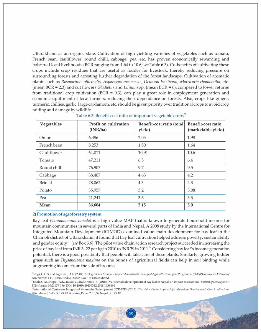
Vegetables Profit on cultivation
(INR/ha)
Benefit-cost ratio (total
yield)
Benefit-cost ratio
(marketable yield)
72Table 6.3: Benefit-cost ratio of important vegetable crops
50
Uttarakhand as an organic state. Cultivation of high-yielding varieties of vegetables such as tomato,
French bean, cauliflower, round chilli, cabbage, pea, etc. has proven economically rewarding and
bolstered local livelihoods (BCR ranging from 1.64 to 10.6; see Table 6.3). Co-benefits of cultivating these
crops include crop residues that are useful as fodder for livestock, thereby reducing pressure on
surrounding forests and arresting further degradation of the forest landscape. Cultivation of aromatic
plants such as Rosmarinus officinalis, Asparagus racemosus, Ocimum basilicum, Matricaria chamomilla, etc.
(mean BCR = 2.3) and cut flowers Gladiolus and Lilium spp. (mean BCR = 6), compared to lower returns
from traditional crop cultivation (BCR = 0.3), can play a great role in employment generation and
economic upliftment of local farmers, reducing their dependence on forests. Also, crops like ginger,
turmeric, chillies, garlic, large cardamom, etc. should be given priority over traditional crops to avoid crop
raiding and damage by wildlife.
2) Promotion of agroforestry system
Bay leaf (Cinnamomum tamala) is a high-value MAP that is known to generate household income for
mountain communities in several parts of India and Nepal. A 2008 study by the International Centre for
Integrated Mountain Development (ICIMOD) examined value chain development for bay leaf in the
Chamoli district of Uttarakhand; it found that bay leaf cultivation helped address poverty, sustainability 73and gender equity (see Box 6.6). The pilot value chain action research project succeeded in increasing the
74price of bay leaf from INR 3–22 per kg in 2010 to INR 39 in 2011. Considering bay leaf’s income generation
potential, there is a good possibility that people will take care of these plants. Similarly, growing fodder
grass such as Thysanolaena maxima on the bunds of agricultural fields can help in soil binding while
augmenting income from the sale of brooms.
Onion 6,386 2.05 1.98
French bean 8,253 1.80 1.64
Cauliflower 64,011 10.91 10.6
Tomato 47,211 6.5 6.4
Round chilli 76,907 9.7 9.5
Cabbage 38,407 4.63 4.2
Brinjal 28,062 4.3 4.3
Potato 35,957 3.2 3.08
Pea 21,241 3.6 3.3
Mean 36,604 5.15 5.0
72Negi, G.C.S. and Agrawal, D.K. (2004). Ecological and Economic Impact Analysis of Diversified Agriculture Support Programme (DASP) in Selected Villages of Uttaranchal. FTR Submitted to DASP, Govt. of Uttarakhand.73Shah, G.M., Nepal, A.K., Rasul, G. and Ahmad, F. (2018). ‘Value chain development of bay leaf in Nepal: an impact assessment’. Journal of Development Effectiveness 10:2: 179-196. DOI: 10.1080/19439342.2018.143849474International Centre for Integrated Mountain Development (ICIMOD) (2013). The Value Chain Approach for Mountain Development: Case Studies from Uttarakhand, India. ICIMOD Working Paper 2013/6. Nepal: ICIMOD.
51
3)Miscellaneous strategies
Interventions such as promoting scientific and community-based management of community forests,
silvi-pasture development, use of chir pine needles and few others (see strategies suggested for mid
altitude zone under Section 6.2) would also be applicable in the low-altitude zone.
Box 6.6: Introducing bay leaf in degraded agroforestry systems
In 2008, ICIMOD conducted an action research project in the Chamoli district of Uttarakhand to
examine value chain development for bay leaf (Cinnamomum tamala). Bay leaf is a high-value MAP
known for generating sustainable household incomes for mountain communities in several parts
of India and Nepal. The research focused on the triple bottom lines of poverty, sustainability and
gender equity in its value chain analysis and explored how these could be addressed. The pilot
value chain project focused on educating and training villagers on cultivating bay leaf trees and
the potential benefits and value additions. The project succeeded in increasing the price of bay leaf
from INR 3–22 per kg in 2010 to INR 39 in 2011, and revealed that the demand for bay leaf remained
unmet locally. The study gave one farmer the opportunity to more extensively participate in
training on the appropriate techniques of collecting saplings and operating a bay leaf tree nursery.
The farmer grew nearly 24,000 saplings in 2010 and sold them at INR 6 per sapling to the Herbal
Research and Development Institute (HRDI). His income from selling the saplings stood at INR
32,000 in 2011, INR 40,000 in 2012, and INR 38,000 in 2013.
6.4 Crosscutting interventions
In Uttarakhand, the fuelwood collected from forests and trees grown in private/community wastelands is
the main source of energy for cooking and other household energy needs. As per Census of India (2011), a
majority of the state’s households (48.7%) use fuelwood, followed by LPG (44.2%) and kerosene (2.9%). In 75rural households, the use of electricity for lighting increased to 83.1% in 2011, up from 50.4% in 2001.
Collection of fuelwood from forests is a major cause of forest degradation, and the burning of biomass a
significant contributor of black carbon in the atmosphere. The smoke generated by inefficient wood
stoves/traditional chulhas in poorly ventilated kitchens exposes women and accompanying children to
the risk of health problems such as asthma. Although the use of LPG for cooking has gone up in recent
years, about half of cooking energy demand is still met from the firewood collected from forests. On a -1 -1regional scale, firewood consumption ranges from 3.4–30.6 kg hh day ; lower consumption is recorded in
low-altitude villages where winters are not harsh and people are better connected with LPG distribution
facilities. People in mid- and high-altitude areas consume higher quantum of firewood. Studies have -1 -1reported that firewood consumption rates for higher altitudes of Pauri are about 13.5 kg hh day , while
-1 -1villages closer to urban townships in Pithoragarh district consume 6.81 kg hh day .
Some specific strategies to address this issue include the following:
75Uttarakhand Power Corporation Ltd (UPCL). Available at: http://www.upcl.org
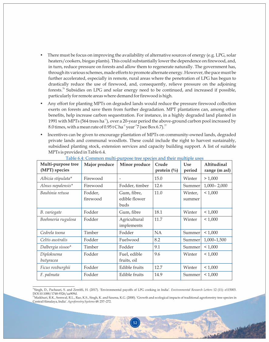
52
• There must be focus on improving the availability of alternative sources of energy (e.g. LPG, solar
heaters/cookers, biogas plants). This could substantially lower the dependence on firewood, and,
in turn, reduce pressure on forests and allow them to regenerate naturally. The government has,
through its various schemes, made efforts to promote alternate energy. However, the pace must be
further accelerated, especially in remote, rural areas where the penetration of LPG has begun to
drastically reduce the use of firewood, and, consequently, relieve pressure on the adjoining 76forests. Subsidies on LPG and solar energy need to be continued, and increased if possible,
particularly for remote areas where demand for firewood is high.
• Any effort for planting MPTs on degraded lands would reduce the pressure firewood collection
exerts on forests and save them from further degradation. MPT plantations can, among other
benefits, help increase carbon sequestration. For instance, in a highly degraded land planted in –11991 with MPTs (564 trees ha ), over a 20-year period the above-ground carbon pool increased by
–1 –7 778.0 times, with a mean rate of 0.95 t C ha year 7 (see Box 6.7).
• Incentives can be given to encourage plantation of MPTs on community-owned lands, degraded
private lands and communal woodlots. These could include the right to harvest sustainably,
subsidised planting stock, extension services and capacity building support. A list of suitable
MPTs is provided in Table 6.4.
Multi-purpose tree
(MPT) speciesMajor produce Crude
protein (%)
Altitudinal
range (m asl)
Albizia stipulata* Firewood - 15.0 Winter > 1,000
Alnus nepalensis* Firewood Fodder, timber 12.6 Summer 1,000– 2,000
Bauhinia retusa Fodder, Gum, fibre, 11.0 Winter, < 1,000
firewood edible flower summer
buds
B. variegate Fodder Gum, fibre 18.1 Winter < 1,000
Boehmeria rugulosa Fodder Agricultural 11.7 Winter < 1,000
implements
Cedrela toona Timber Fodder NA Summer < 1,000
Celtis australis Fodder Fuelwood 8.2 Summer 1,000–1,500
Dalbergia sissoo* Timber Fodder 9.1 Summer < 1,000
Diploknema Fodder Fuel, edible 9.6 Winter < 1,000
butyracea fruits, oil
Ficus roxburghii Fodder Edible fruits 12.7 Winter < 1,000
F. palmata Fodder Edible fruits 14.9 Summer < 1,000
Table 6.4: Common multi-purpose tree species and their multiple uses
Minor produce Use
period
76Singh, D., Pachauri, S. and Zerriffi, H. (2017). ‘Environmental payoffs of LPG cooking in India’. Environmental Research Letters 12 (11): e115003. DOI:10.1088/1748-9326/aa909d.77Maikhuri, R.K., Semwal, R.L., Rao, K.S., Singh, K. and Saxena, K.G. (2000). ‘Growth and ecological impacts of traditional agroforestry tree species in Central Himalaya, India’. Agroforestry Systems 48: 257–272.
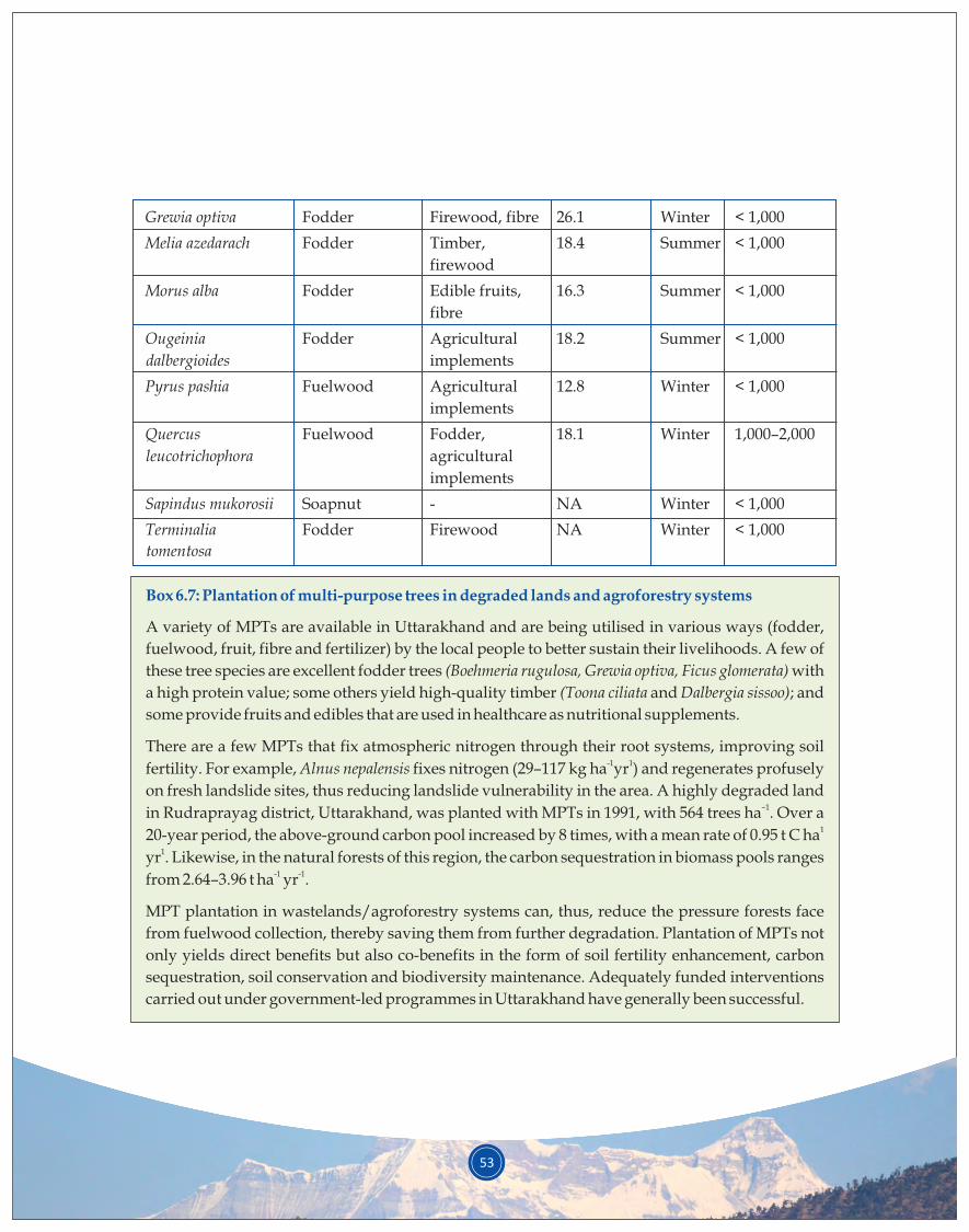
53
Grewia optiva Fodder Firewood, fibre 26.1 Winter < 1,000
Melia azedarach Fodder Timber, 18.4 Summer < 1,000
firewood
Morus alba Fodder Edible fruits, 16.3 Summer < 1,000
fibre
Ougeinia Fodder Agricultural 18.2 Summer < 1,000
dalbergioides implements
Pyrus pashia Fuelwood Agricultural 12.8 Winter < 1,000
implements
Quercus Fuelwood Fodder, 18.1 Winter 1,000–2,000
leucotrichophora agricultural
implements
Sapindus mukorosii Soapnut - NA Winter < 1,000
Terminalia Fodder Firewood NA Winter < 1,000
tomentosa
NA= Not available* Nitrogen fixer species
Box 6.7: Plantation of multi-purpose trees in degraded lands and agroforestry systems
A variety of MPTs are available in Uttarakhand and are being utilised in various ways (fodder,
fuelwood, fruit, fibre and fertilizer) by the local people to better sustain their livelihoods. A few of
these tree species are excellent fodder trees (Boehmeria rugulosa, Grewia optiva, Ficus glomerata) with
a high protein value; some others yield high-quality timber (Toona ciliata and Dalbergia sissoo); and
some provide fruits and edibles that are used in healthcare as nutritional supplements.
There are a few MPTs that fix atmospheric nitrogen through their root systems, improving soil -1 1fertility. For example, Alnus nepalensis fixes nitrogen (29–117 kg ha yr ) and regenerates profusely
on fresh landslide sites, thus reducing landslide vulnerability in the area. A highly degraded land –1in Rudraprayag district, Uttarakhand, was planted with MPTs in 1991, with 564 trees ha . Over a
120-year period, the above-ground carbon pool increased by 8 times, with a mean rate of 0.95 t C ha 1yr . Likewise, in the natural forests of this region, the carbon sequestration in biomass pools ranges
-1 -1from 2.64–3.96 t ha yr .
MPT plantation in wastelands/agroforestry systems can, thus, reduce the pressure forests face
from fuelwood collection, thereby saving them from further degradation. Plantation of MPTs not
only yields direct benefits but also co-benefits in the form of soil fertility enhancement, carbon
sequestration, soil conservation and biodiversity maintenance. Adequately funded interventions
carried out under government-led programmes in Uttarakhand have generally been successful.
India has a strong policy and legal framework on environment and forests. The Ministry of Environment,
Forest and Climate Change (MoEFCC) is the national nodal agency for planning, co-ordination and
monitoring the implementation of India's environmental and forestry policies and programmes. In 1952,
India adopted its first National Forest Policy (NFP), which advocated for bringing at least one-third of the
country’s total geographical area under forests or tree cover, with a minimum of two-thirds of the hilly
areas under green cover. The policy was revised in 1988 as the focus shifted from production forestry to
conservation of forests and maintaining the ecological security of the country. The Wildlife Protection Act
was enacted in 1972, and it remains one of the most comprehensive and strong wildlife laws in the world.
With a view to regulate diversion of forests for developmental projects, the Forest (Conservation) Act was
enacted in 1980. It stipulates that forest land can be diverted for non-forestry purposes only after due
diligence process, and also included a mechanism to compensate for the diverted forest land to offset the
loss. The Compensatory Afforestation Fund Management and Planning Authority (CAMPA) Act, 2016,
seeks to provide institutional mechanisms to ensure appropriate utilisation of the funds realised in lieu of
the diverted forest land. The Forest Rights Act (FRA), 2006, recognised both individual rights to cultivated
land in forest land and community rights over common property resources, thus encouraging sustainable
use by forest-dependent communities. The National Agroforestry Policy, 2014, is directed at promoting
sustainable and resilient agricultural practices that generate income and improve livelihoods. The country
has set in place institutional frameworks to operationalise these policies and acts, aiming to address the
various aspects relating to management of forests and other landscapes. Initiatives to this end include: The
National Bamboo Mission, National Green Highway Mission, National Mission for a Clean Ganga,
National Afforestation Programme (NAP), National Mission for a Green India (GIM), etc. The
Government of India has also initiated a few other relevant missions and programmes to promote
restoration in the country. While the established institutions are supporting various programmes relating
to afforestation and restoration of forests and other landscapes, lack of convergence between the multiple
programmes and restoration efforts hinders greater impact on the ground.
The ROAM study of Uttarakhand’s forest restoration priorities entailed a series of consultations with
various line departments and agencies and brought to the fore the need for greater convergence to avoid
duplication of efforts and resources. This report, summarising the findings of the assessment, highlights
the identified restoration priorities across the three elevation zones and seeks to inform detailed state- and
district-level planning for restoration of various categories of land uses, including forested landscapes.
The report also identifies the agencies that are involved in restoration programmes for the different types
of land in Uttarakhand. While the forest department is the custodian of the major part of the landscape and
would be the main line agency for restoration efforts in the state, other agencies are involved in restoration
activities in other categories of landuse. These include the departments of horticulture and agriculture,
7. OPPORTUNITIES AND ROADMAP FOR THE FUTURE
54
55
Uttarakhand Livestock Development Board (ULDB), SBB, Forest Survey of India, Indian Institute of Soil
and Water Management, DMMC, WMD, State Climate Change Centre (SCCC), SMPB, and Centre for
Aromatic Plants (CAP), among others. The programmes being implemented by these line agencies are
captured in the report (see Table 4.1 and Appendix 3). Convergence between the relevant line agencies is
often lacking, which the FLR approach in general and the application of ROAM in particular have
attempted to bridge by both involving and informing multiple stakeholders throughout the process.
An important opportunity for convergence lies in the planning process. The forest department has
working plans for the management of territorial forest divisions and management plans for protected
areas; these are usually formed for a decade. The Government of India already has a National Working
Plan Code, 2014, for formulation of future plans; ROAM could potentially complement it. This ROAM
report demonstrates how it could support the working and management plans by adopting a landscape
approach and a framework for cross-sectoral holistic planning while drafting the new plans. The
Uttarakhand Watershed Management Directorate (UKWMD), which has developed the Uttarakhand
State Perspective and Strategic Plan, 2009–2027, could benefit from the FLR priority map generated
through ROAM to implement its watershed restoration. Similarly, other agencies in the state, such as
DMMC, CAP, SMPB, SBB) and SCCC, could take up specific recommendations from the report to avoid
duplication of effort.
Some of the report’s recommendations and restoration strategies are already being adopted in the state.
For instance, the District Magistrate of Pithoragarh has started organising a GIS cell to ensure convergence
of all mapping exercises within the district. This would ensure a common repository of information for
easy access by all line departments. Similarly, there is evident interest in piloting cultivation of crops like
large cardamom and other identified crops to provide good returns. The Uttarakhand forest department
has also started identifying and restoring dry springs within the forested areas of the state with support
from United Nations Development Programme (UNDP).
Along with converging resources of relevant line agencies, additional funds will need to be secured to
enable implementation of the strategies and recommendations proposed by ROAM. There is scope for
accessing funds for the required manpower efforts from MGNREGA. The National Bank for Agriculture
and Rural Development (NABARD) is another possible source for financing. NABARD is an apex
development bank with the mission of promoting sustainable and equitable agriculture and rural
development through participative financial and non-financial interventions, innovations, technology
and institutional development to secure prosperity.
Private sector engagement should be a strong consideration for implementation of the suggested
strategies, especially the ones with a strong livelihood component. The Tata Trusts is already present in
the landscape through the Himmothan Society it set up in 2007. Himmothan currently focuses on the
following three initiatives: (i) Central Himalayan Livestock Initiative, (ii) Central Himalayan
Microfinance Initiative, and (iii) Central Himalayan Education Initiative. IUCN could facilitate dialogue
56
between the state government and Tata Trusts to explore convergence between their existing programmes
and ROAM recommendations. Given that Tata Trusts is keen to expand its portfolio in the region, a new
programme informed by the ROAM study could be developed for the region.
It is important to note here that in 2014 the Ministry of Corporate Affairs (MCA) notified Section 135 and
Schedule VII of the Companies Act, 2013, which relate to corporate social responsibility (CSR). The law has
made it mandatory for companies with minimum INR 5 crore net profit, INR 1,000 crore turnover, or INR
500 crore net worth to spend 2% of their 3-year average annual net profit on CSR activities every financial
year, starting 2015. IUCN India has a strong business and biodiversity portfolio that could also be engaged
to explore financing for implementation of ROAM recommendations. Leaders for Nature, the business
and biodiversity network of IUCN that stimulates and facilitates companies to take the lead in transition
towards a sustainable green Indian economy by incorporating natural capital in their core business, could
be a potential option for leveraging funds.
The ROAM findings could be utilised by Uttarakhand to develop proposals for central programmes such
NAP, GIM, as well as the newly established National Agroforestry Policy. The findings could also be
utilised to develop large landscape-level programmes supported by bilateral/multilateral funding.
Additionally, the state could utilise this report to inform the development of a large project under the
Global Environment Facility (GEF) and the Green Climate Fund (GCF). India has secured a US$ 717.52
million grant from GEF since 1991 for 99 projects. GEF 6 India allocation for land degradation was
approximately US$ 5 million, while the focal areas of biodiversity and climate change received allocations
of nearly US$ 36 million and US$ 87 million, respectively. The Government of Uttarakhand could, thus,
consider GEF funding to develop and implement an FLR framework for the state. The GCF was
established to assist developing countries in adaptation and mitigation practices to counter climate
change. The Government of India has indicated keen interest in engaging with the GCF, and the time is
right for Uttarakhand to develop a GCF proposal based on the findings of the ROAM study.
The state of Uttarakhand is already implementing various programmes funded by several bilateral and
multilateral agencies such as the World Bank, JICA, GIZ and UNDP, among others. The World Bank’s
Biodiversity Conservation & Rural Livelihood Improvement Project (BCRLIP) has the Askot Wildlife
Sanctuary in Pithoragarh district as one of its pilot intervention sites. The World Bank is also funding the
Uttarakhand Disaster Recovery Project, which aims to restore housing and rural connectivity, build
resilience within communities in Uttarakhand, and increase the technical capacity of the state entities to
respond promptly and effectively to emergencies.
JICA is supporting the Uttarakhand Forest Resource Management Project (UFRMP) to address the issue of 78forest degradation in the state. Under this project, 13 forest divisions and 37 forest ranges have been
selected to address forest degradation in 750 van panchayats. JICA recently added a component of disaster
management by signing an agreement with the state to provide technical assistance to the state
78The 13 forest divisions include: Alakhnanda Soil conservation, Civil Soyam (Pauri), Tehri Dam I, Narendra Nagar, Lansdowne Soil, Ramnagar Soil, Ranikhet Soil, Civil Soyam (Almora), Nainital Soil, Bageshwar, Champawat, Pithoragarh and Mussoorie Forest Division.
57
government, specifically the forest department, for appropriately planning and implementing erosion
control works for slope disaster management in forest areas, aiming towards a future preparedness
strategy. The ROAM recommendations specific to disaster management could be funded or implemented
with JICA support, as the forest department is already the key stakeholder for the project.
UNDP had supported the state in developing its State Action Plan on Climate Change (SAPCC), and is
currently supporting SAPCC implementation through funding from the Swiss Agency for Development
and Cooperation (SDC). The International Fund for Agricultural Development (IFAD) is supporting the
Integrated Livelihood Support Project (ILSP) in Uttarakhand; the project is being implemented through
the Uttarakhand Gramya Vikas Samiti (UGVS), WMD, and the Uttarakhand Parvatiya Aajeevika
Sanvardhan Company. The three main components of the project are: supporting crop and livestock
production for food security, implementing participatory watershed management and livelihoods
financing. There is potential for integrating the recommendations of the ROAM study and the FLR
interventions into the existing IFAD programme in the state. The findings of ROAM will complement
ecological, socio-economic and financial components of the existing programme.
Additional efforts have also focused on identifying where the key priorities of restorative action must lie.
A UNDP study carried out vulnerability analysis at district and block levels in Uttarakhand, based on 79composite vulnerability index (CVI) derived through multivariate analysis of the current climate.
Projected vulnerability for projected climate was also assessed, based only on those environmental
indicators that could be derived using biophysical impact assessment models for mid- and end-century
using IPCC AR5 RCP4.5 and RCP8.5 scenarios. The study found that the districts of Champawat and Tehri
Garhwal currently fall under very high vulnerability category due to their relatively low adaptive
capacity, higher sensitivity and exposure compared to other districts. Districts of Haridwar, Almora and
Bageshwar fall under high vulnerability category; districts of Uttarkashi, Pauri Garhwal, Udham Singh
Nagar and Rudraprayag fall under moderate vulnerability category; Chamoli and Pithoragarh fall under
low vulnerability category; and Nainital and Dehradun fall under very low vulnerability. However, with
regards the projected climate, districts that are currently vulnerable are projected to exacerbate further
towards mid-century, mainly due to the impact of increased temperature and variable precipitation on
forests, health and natural disasters; even the districts in low vulnerability category are projected to reach
the moderately vulnerable category.
Convergent action towards climate change adaptation and mitigation is, thus, an urgent priority for the
state, as it lies within the Himalayas, a region severely affected by the vagaries of climate change. The
ROAM study has provided vital information on the ecological, social and physical attributes of the state,
bringing them together on an easy-to-comprehend and readily visualised spatial layer. This will facilitate
holistic, collaborative planning and implementation of restoration interventions, avoid duplication of
resources and efforts and have a greater positive impact on the ecology, environment and lives of people
in Uttarakhand.
79INRM Consultants. (2016): Climate Change Risks and Opportunities in Uttarakhand, India. Technical Report on District (Block) Level Vulnerability for Select Sectors. Submitted to UNDP and Government of Uttarakhand. Dehradun: IISc & GCRS.
Agarwal, A. (1996). ‘Group Size and Successful Collective Action: A Case Study of Forest Management
Institutions in the Indian Himalayas’. In: Gibson, C., McKean, M.A., and Ostrom, E. (eds), Forest Resources
and Institutions, Forest Trees and People Programme – Forestry Department, Working Paper No. 3. Rome: Food
and Agricultural Organization.
Agrawal, D.K. and Rikhari, H.C. (1998). ‘Mountain risk engineering: Low-cost physical and biological
measures for control of small hill slope instability’. In: Research for Mountain Development: Some Initiatives
and Accomplishments, pp. 119–144. Gyanodaya Prakashan, Nainital: GBPIHED.
Agrawal, D.K., Krishna, A.P. Joshi, V. Kumar, K. and Palni, L.M.S. (1997) (eds.). Perspectives of Mountain
Risk Engineering in the Himalayan region. Gyanodaya Prakashan, Nainital.
Airi, S. and Rawal, R.S. (2017). ‘Patterns of vegetation composition across levels of canopy disturbance in
temperate forests of west Himalaya, India’.Biodiversity: Research and Conservation 45: 21-27.
Anon. (1992).The Forest Problem of Kumaun. Gyanodaya Prakashan. Nainital, India: G.B. Pant Institute of
Himalayan Environment & Development.
Anon. (2016).Crisis management plan. Forest Department, Government of Uttarakhand.
rdAnon. (2017). 293 Report of Department Related Parliamentary Standing Committee on Science &Technology.
Environment & Forests, GoI.
Bhuvan- ISRO/NSRC. ‘District and category wise distribution of land use/land cover in Uttarakhand
(2011-12) ’. Available at: http://bhuvan.nrsc.gov.in/gis/thematic/tools/document /LULC502/MAP/
UK.pdf (Accessed: 10 May 2018).
Bisht, R. (2002). Environmental health in Garhwal Himalaya: A study of Pauri Garhwal. New Delhi, India: Indus
Publishing.
Bonn Challenge. Available at:http://www.bonnchallenge.org/
Brown, P.M., Bhattacharyya, A. and Shah, S.K. (2011). ‘Potential for developing fire histories in Chir pine
(Pinusroxburghii) forests in the Himalayan foothills’. Tree-Ring Research 67 (1): 57-62
Census of India (2011).Office of the Registrar General & Census Commissioner, India. Available
at:http://censusindia.gov.in/2011-common/censusdataonline.html
Center for Ecology Development and Research (CEDAR) (2015). Climate Change in Uttarakhand: Current
State of Knowledge and Way Forward. Dehradun, India: CEDAR.
Chowdhury, R. and Flentje, P. (2003). 'Role of slope reliability analysis in landslide risk
BIBLIOGRAPHY
58
59
management'.Bulletin of Engineering Geology and the Environment 62 (1): 41-46.
Dangwal, D.D. (2005). 'Commercialisation of Forests, Timber Extraction and Deforestation in Uttaranchal,
1815-1947'. Conservation and Society 3(1): 110-133.
DMMC Report. (2012). State Disaster Management Action Plan for the State of Uttarakhand. Disaster
Mitigation & Management Centre, Uttarakhand Secretariat, Rajpur Road, Dehradun. Available at:
http://dmmc.uk.gov.in/files/pdf/complete_sdmap.pdf
Doelman, P. and Eijsackers, H.J.P. (eds.) (2004). Vital Soil: Function, Value and Properties. Volume 29 of
Developments in Soil Science. Amsterdam, The Netherlands: Elsevier. ISBN 0-444-51772-3 DOI:
10.1016/j.agsy.2006.03.011.
Forest Survey of India.(2017). India State of Forest Report 2017. Dehradun, India: FSI.
Germain, R., Ghosh, C. and Jayasuriya, M. (2017). 'Community Forestry in the State of Uttarakhand, India:
Not Meeting the Needs of the Villagers'. Small-scale Forestry. Available at: https://doi.org/10.1007/s11842-
017-9384-z
Gosain, B.G., Negi, G.C.S.,Dhyani, P.P.,Bargali, S.S. and Saxena, R. (2015). 'Ecosystem Services of Forests:
Carbon Stock in Vegetation and Soil Components in a Watershed of Kumaun Himalaya, India'.
International Journal of Ecology and Environmental Sciences 41 (3-4): 177-188.
Ilyas, O. and Khan, J.A. (2005). 'Assessment of tree mortality and post fire regeneration pattern in Binsar
Wildlife Sanctuary Kumaon Himalaya'.Tropical Ecology 46(2): 157-163.
INRM Consultants. (2016): Climate Change Risks and Opportunities in Uttarakhand, India. Technical Report on
District (Block) Level Vulnerability for Select Sectors. Submitted to UNDP and Government of
Uttarakhand. Dehradun: IISc& GCRS.
International Centre for Integrated Mountain Development (ICIMOD) (2013).The Value Chain Approach for
Mountain Development: Case Studies from Uttarakhand, India. ICIMOD Working Paper 2013/6. Nepal:
ICIMOD.
IUCN and WRI (2014). A guide to the Restoration Opportunities Assessment Methodology (ROAM): Assessing
forest landscape restoration opportunities at the national or sub-national level. Working Paper (Road-test edition).
Gland, Switzerland: IUCN.
Jackson, M.G. (1981). Livestock in the economy of the Himalayan foothills. GBPUA&T, Pantnagar.
Joshi, B. (2013). Annual report of project 7.Almora: GBPIHED.
Kumar, K., Dhyani, P.P. and Palni, L.M. (1996). 'Land Utilization in the Central Himalaya: Problems and
Management Options'. Himavikas 8. Almora: GBPIHED.
Kuniyal, C.P., Kuniyal, P.C., Butola, J.S. and Sundriyal, R.C. (2013). 'Trends in the marketing of some
60
important medicinal plants in Uttarakhand, India'. International Journal of Biodiversity Science, Ecosystem
Services & Management 9(4): 324-329.
Laestadius, L., Maginnis, S., Minnemeyer, S., Potapov, P., Saint-Laurent, C. and Sizer, N. (2011). 'Mapping
opportunities for forest landscape restoration'. Unasylva 238 (62): 47-48.
Li, Y., Yang, X., Cai, H., Xiao, L. Xu, X. and Liu, L. (2015). 'Topographical Characteristics of Agricultural
Potential Productivity during Cropland Transformation in China'. Sustainability 7: 96-110.
doi:10.3390/su7010096.
Mahamuni, K. and Kulkarni, H. (2012). 'Groundwater Resources and Spring Hydrogeology in South
Sikkim, with Special Reference to Climate Change'. In: Arrawatia. M.L. and Tambe, S. (eds.) Climate
change in Sikkim - Patterns, Impacts and Initiatives, pp. 261-274. Gangtok: Information and Public
Relations Department, Government of Sikkim.
Maharana, I., Rai, S. and Sharma, E. (2000). 'Valuing ecotourism in a sacred lake of the Sikkim Himalaya,
India'. Environmental Conservation 27(3): 269-277.
Maikhuri, R.K., Semwal, R.L., Rao, K.S., Singh, K. and Saxena, K.G. (2000). 'Growth and ecological impacts
of traditional agroforestry tree species in Central Himalaya, India'. Agroforestry Systems 48: 257–272.
Mamgain, R.P. and Reddy, D.N. (2015). Outmigration from hill region of Uttarakhand: Magnitude, Challenges
and Policy Options. Hyderabad: National Institute of Rural Development and Panchayati Raj. Available at:
http://www.nird.org.in/nird_docs/srsc/srscrr261016-3.pdf
McNab, W.H. (2010). 'Effects of landform on site index of two mesophytic tree species in the Appalachian
Mountains of western North Carolina, USA'. International Journal of Forestry Research. 2010: 1–7. doi:
10.1155/2010/298674.
Nagarwalla, D.J. and Agrawal, A. (2009). 'Uttarakhand State Chapter'. In: Pathak, N. (ed.) Community
Conserved Areas in India - A Directory, pp.707-730. Pune/ Delhi: Kalpavriksh.
Nautiyal, A. (2015). ''Is Chir Pine displacing Banj Oak in the Central Himalaya? Socioeconomic
implications for local people and the conservation of Oak forest biodiversity'. PhD Dissertation.
University of Arkansas. Available at: http://scholarworks.uark.edu/cgi/ viewcontent.cgi?
article=2329& context=etd
Nautiyal, J.C. and Babor, P.C. (1985). 'Forestry in the Himalayas: How to Avert an Environmental
Disaster'. Interdisciplinary Science Reviews 10(1): 27-41.
Nautiyal, M.C. and Nautiyal, B.P. (2004). Agrotechniques of High Altitude Medicinal and Aromatic Plants.
Bishen Singh Mahendra Pal Singh, Dehradun.
Nayak, B.P., Kohli, P. and Sharma, J.V. (2013). Livelihood of local communities and forest degradation in India:
issues for REDD+. New Delhi, India: MoEFCC, Govt. of India and TERI.
61
Negi, G.C.S. and Agrawal, D.K. (2004). Ecological and Economic Impact Analysis of Diversified Agriculture
Support Programme (DASP) in Selected Villages of Uttaranchal. FTR Submitted to DASP, Govt. of
Uttarakhand.
Negi, G.C.S. and Dhyani, P.P. (2014). 'Suitable multipurpose tree species for restoration of wastelands in
the western Himalayan mountains in India'. International Journal of Current Research 6(10): 9024–9027.
Negi, G.C.S., Maikhuri, R.K. and Dhyani, P.P. (2016). Forest Fire of 2016 in Uttarakhand: Causes, Consequences
and Some Remedial Measures. Approach Paper on "Recent Forest Fires in Uttarakhand and its Effect on
Environment, Forests, Biodiversity and Wildlife and Remedial/Preventive Measures", submitted to
Department-related Parliamentary Standing Committee on Science & Technology, Environment &
Forests to Uttarakhand, 6-7 June, Mussoorie, Uttarakhand.
Negi, G.C.S., Rawal, R.S. and Dhyani, P.P. (2015). 25 Glorious Years of GBPIHED: Translating Research into
Action. Almora, Uttarakhand: GBPIHED.
Pandey, J.C., Gangwar, P., Kumar, N. and Grewal, N. (2014). 'Pine Briquetting- An Endeavour for Green
Fuel'. Indian Forester 140(5): 478-482.
Pathak, S., Pant, L. and Mahajan, A. (2017). Depopulation trends, patterns and effects. Nepal: ICIMOD.
Phondani, P.C., Bhatt, I.D., Negi, V.S., Kothyari, B.P., Bhatt, A. and Maikhuri, R.K. (2016). Promoting
medicinal plants cultivation as a tool for biodiversity conservation and livelihood enhancement in Indian
Himalaya. Journal of Asia-Pacific Biodiversity 9(1): 39-46. doi.org/10.1016/j .
Phondani, P.C., Negi, V.S., Bhatt, I.D., Maikhuri, R.K. and Kothyari, P.B. (2011). 'Promotion of medicinal
and aromatic plants cultivation for improving livelihood security: A case study from West Himalaya,
India'. Indian Journal of Medicinal and Aromatic Plants 1 (3): 245-252.
Rautela, P., Joshi, G.C. and Bhaisora, B. (2011). 'Seismic vulnerability of the health infrastructure in the
Himalayan township of Mussoorie, Uttarakhand, India'. International Journal of Disaster Resilience in the
Built Environment 2 (3), 200-209.
Rawat, G. S. (2007). 'Pastoral Practices, Wild Mammals and Conservation Status of Alpine Meadows in
Western Himalaya'. Journal of Bombay Natural History Society 104 (1): 251-257.
Rawat, S., Jugran, A.K., Bhatt, I.D. and Rawal, R.S. (2018). 'Hedychium spicatum: a systematic review on
traditional uses, phytochemistry, pharmacology and future prospects'. Journal of Pharmacy and
Pharmacology 70(3): doi:10.1111/jphp.12890.
Roy, P.S. (2003). 'Forest Fire and Degradation Assessment using Satellite Remote Sensing and Geographic
Information System', paper delivered at the Satellite Remote Sensing and GIS Applications in Agricultural
Meteorology Proceedings of the Training Workshop, Dehra Dun, India, 7-11 July, 2003.
Shah, G.M., Nepal, A.K., Rasul, G. and Ahmad,F. (2018). 'Value chain development of bay leaf in Nepal: an
62
impact assessment'. Journal of Development Effectiveness 10:2: 179-196. DOI: 10.1080/
19439342.2018.1438494.
Shahabudin, G. (2013). 'Himalayan oak forests under threat'. Down to Earth. Available at:
http://www.downtoearth.org.in/blog/himalayan-oak-forests-under-threat-41826.
Sharma, E. and Ambasht, R. (1984). 'Seasonal variation in nitrogen fixation by different ages of root
nodules of Alnus nepalensis plantations, in the Eastern Himalayas'.Journal of Applied Ecology 21: 265–270.
Sharma, S. and Pant, H. (2017). 'Vulnerability of Indian Central Himalayan Forests to Fire in a Warming
Climate and a Participatory Preparedness Approach Based on Modern Tools'. Current science 112 (10):
2100-2105. Available at DOI: 10.18520/cs/v112/i10/2100-2105.
Sharma, S. and Rikhari, H.C. (1997). 'Forest fire in the central Himalaya: climate and recovery of trees'.
International Journal of Biometeorology 40(2): 63-70.
Sidhu, G.S. and Yadav, R.P. (2014). 'Soil Degradation in North-West Himalayas (NWH): A Case Study of
Himachal Pradesh'. In: Bisht J., Meena V., Mishra P., Pattanayak A. (eds.) Conservation Agriculture. Pp.
381-408. Singapore: Springer.
Singh, D., Pachauri, S. and Zerriffi, H. (2017).'Environmental payoffs of LPG cooking in
India'.Environmental Research Letters 12 (11): e115003. DOI:10.1088/1748-9326/aa909d.
Singh, G. and Rawat, G.S. (2012). 'Depletion of Oak (Quercus spp.) Forests in the Western Himalaya:
Grazing, Fuelwood and Fodder Collection'. In :Okia, C.A. (eds.). Global Perspectives on Sustainable Forest
Management .In Tech Open. ISBN: 978-953-51-0569-5, DOI: 10.5772/2634.
Singh, J.S. (1997). 'Forests of Himalaya with particular reference to man and forest interactions in Central
Himalaya'. Proceedings of the Indian National Science Academy B63 (3):151-173.
Singh, J.S., Rawat, Y.S. and Chaturvedi, O.P. (1984). 'Replacement of oak forest with pine in the Himalaya
effects the nitrogen cycle'. Nature 311: 54-56.
Singh, K. and Singh, H.S. (2009) 'Forage resource development in Uttarakhand: Experiences and
observations'. Unpublished report of Uttarakhand Livestock Board. Available at:
http://www.uldb.org/pdf/Forage%20Resources_FDP_.pdf
Singh, S.P. (1998). 'Chronic disturbance, a principal cause of environmental degradation in developing
countries'. Environmental Conservation, 25 (1): 1-2.
Singh, S.P. (2014). 'Attributes of Himalayan Forest Ecosystems: They are not Temperate Forests'.
Proceedings of Indian National Science Academy 80(2): 221-233.
Singh, S.P. and Singh, J.S. (1991). 'Analytical conceptual plan to reforest Central Himalaya for sustainable
development'. Environmental Management 15: 369-379.
63
Singh, S.P., Rawat, Y.S. and Garkoti, S.C. (1997). 'Failure of brown oak (Quercus semecarpifolia) to
regenerate in central Himalaya: A case of environmental semisurprise'. Current Science 73(4): 371-374.
Sirvi, A., Dhyani, S. and Dev, I. (2016).'Potential of agroforestry systems in carbon sequestration in
India'.Indian Journal of Agricultural Sciences 86: 1103-1112.
Thakur, A.K. and Singh, D. (2014). 'Forest Fire Risk Zonation Using Geospatial Techniques and Analytic
Hierarchy Process in Dehradun District, Uttarakhand, India'. Universal Journal of Environmental Research
and Technology 4(2): 82-89.
The Energy and Resources Institute (2013). Identification of Medicinal and Aromatic Plants Suitable for
Cultivation and Inclusion in Afforestation and Income Generation Programmes for the State of Uttarakhand.
Submitted to State Medicinal Plants Board (SMPB), Uttarakhand. Dehradun: TERI.
Uttarakhand Power Corporation Ltd (UPCL). Available at: http://www.upcl.org
Valdiya, K.S. and Bartarya, S.K. (1989). 'Diminishing discharge of mountain springs in a part of Kumaun
Himalaya'. Current Science 58: 417–426.
Appendix 1: Intensive sample sites– Pithoragarh and Garhwal
Pithoragarh district
The district of Pithoragarh (29.4° to 30.3° N latitude and 80° to 81° E longitude) is located in the eastern part
of Uttarakhand with the Indo-Tibetan (China) watershed divide in the north and the Kali River in the east,
forming a border with Nepal. With its wide altitudinal range, the district covers most of the eco-climatic
conditions (i.e. sub-tropical to high-alpine) and is, therefore, representative of most of the state's eco-
climate. The entire district has been included as part of the Greater Mt. Kailash Sacred Landscape, a
transboundary area within the geographical boundaries of China, India and Nepal, and is one of the seven
identified landscapes for transboundary landscape conservation and development in Hindu Kush
Himalayan Region. The landscape is recognised for its wilderness and is vulnerable to developmental
pressures and risks from changes in global climate.
With its wide altitudinal range (<500–>6,400 m asl), the district covers three major physiographic zones:
the Trans-Himalaya (40%), the Greater Himalaya (20%) and the Lesser Himalaya (40%). These landscapes
comprise areas with 35% permanent snow cover, 32% forest cover, 5.2% alpine meadows and 3.9% high-
altitude grasslands and rocks. The area under operational agriculture is 6.3% and fallow land represents
5.6%. Other land classes include grasslands and forest blanks (4.8%) and barren land (6.3%).
This landscape forms an integral part of an identified potential agricultural biodiversity heritage site in
India – the western Himalayan region – where local communities have, from time immemorial, explored
diverse forms of production based on locally available resources, resulting in traditional cultivation of a
large number of plant species. Livelihoods in the region are predominantly driven by traditional
agriculture, livestock rearing and traditional use of forest resources. As per the Census of 2011, the human
population of Pithoragarh is 4,83,439 (2,39,306 male; 2,44,133 female), which represents about 4.8% of the
state’s population. A significant 84% of the district’s population resides in rural areas. The people,
especially indigenous tribal communities (i.e. Bhotiyas and Rajis), possess deep knowledge of the use and
conservation of locally available bio-resources.
The Pithoragarh district includes the following representative eco-regions: (i) Himalayan sub-tropical chir
pine forests, (ii) west Himalayan broad-leaf forests, (iii) west Himalayan sub-alpine conifer forests, and (iv)
west Himalayan alpine shrubs and meadows. From high to low altitudes, the original habitats include:
alpine and subnival habitats, timberline ecotone and sub-alpine forests, cool temperate grassy slopes,
temperate forests and scrubs, sub-tropical forests and secondary scrubs, and riverine habitat. In terms of
forests, there are 14 dominant forest types.
Van panchayats represent nearly 16% of the forests and form a strong, traditional community management
system for forests in the landscape. The Van Panchayat Act, 1931, and its amendment in 1976, have made it
APPENDICES
64
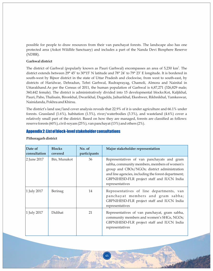
65
possible for people to draw resources from their van panchayat forests. The landscape also has one
protected area (Askot Wildlife Sanctuary) and includes a part of the Nanda Devi Biosphere Reserve
(NDBR).
Garhwal district
2The district of Garhwal (popularly known as Pauri Garhwal) encompasses an area of 5,230 km . The
district extends between 29° 45’ to 30°15’ N latitude and 78° 24’ to 79° 23’ E longitude. It is bordered in
south-west by Bijnor district in the state of Uttar Pradesh and clockwise, from west to south-east, by
districts of Haridwar, Dehradun, Tehri Garhwal, Rudraprayag, Chamoli, Almora and Nainital in
Uttarakhand.As per the Census of 2011, the human population of Garhwal is 6,87,271 (326,829 male;
360,442 female). The district is administratively divided into 15 developmental blocks:Kot, Kaljikhal,
Pauri, Pabo, Thalisain, Bironkhal, Dwarikhal, Dugadda, Jaiharikhal, Ekeshwer, Rikhnikhal, Yamkeswar,
Nainidanda, Pokhra and Khirsu.
The district’s land use/land cover analysis reveals that 22.9% of it is under agriculture and 66.1% under
forests. Grassland (1.6%), habitation (1.5%), river/waterbodies (3.3%), and wasteland (4.6%) cover a
relatively small part of the district. Based on how they are managed, forests are classified as follows:
reserve forests (60%), civil-soyam (25%), van panchayat (13%) and others (2%).
Pithoragarh district
Appendix 2: List of block-level stakeholder consultations
Date of
consultation
2 June 2017 Representatives of van panchayats and gram
sabha, community members, members of women's
group and CBOs/NGOs; district administration
and line agencies, including the forest department;
GBPNIHESD-FLR project staff and IUCN India
representatives
Bin, Munakot
Blocks
covered
No. of
participants
Major stakeholder representation
36
1 July 2017 Representatives of line departments, van
p a n c h a y a t m e m b e r s a n d g r a m s a b h a ;
GBPNIHESD-FLR project staff and IUCN India
representatives
Berinag 14
1 July 2017 Representatives of van panchayat, gram sabha,
community members and women’s SHGs, NGOs;
GBPNIHESD-FLR project staff and IUCN India
representatives
Didihat 21

Date of
consultation
19 July 2017 Representative of line departments, van panchayat
members, gram sabha, community members and
peoples’ representatives; GBPNIHESD-FLR
project staff
Kanalichhina
Blocks
covered
No. of
participants
Major stakeholder representation
53
21 July 2017 Representatives of line departments, van
panchayat members, women’s SHGs and elected
people’s representatives; GBPNIHESD-FLR
project staff
Dharchula 36
3 Aug 2017 Representatives of line departments, van
panchayat members, gram pradhans (village heads)
a n d r e p r e s e n t a t i v e s o f N G O s / C B O s ;
GBPNIHESD- FLR project staff
Munsiyari 28
5 Aug 2017 Representatives of line departments, van
p a n c h a y a t m e m b e r s , g r a m s a b h a a n d
representatives of NGOs; GBPNIHESD-FLR
project staff
Gangolihat 23
Garhwal district
Date of
consultation
19 Sept 2017 Departmental heads of relevant line departments
in Garhwal district (District Magistrate, CDO,
DDO, DFO, DDO, PD DRDA, CHO, CAO, IWMP,
Gramya, ILSP, Minor Irrigation, Disaster
Management Unit, DIO and BDOs of Pauri and
Khirsu); van panchayat and gram sabha;
GBPNIHESD-FLR project staff and IUCN India
representatives
Pauri, Pabo,
Kot, Khirsu,
Kaljikhal,
Ekeshwar
Blocks
covered
No. of
participants
Major stakeholder representation
59
21 Sept 2017 Representativesof line departments, van
panchayats and gram sabha; GBPNIHESD-FLR
project staff
Dugadda,
Dwarikhal,
Pokhra,
Rikhanikhal,
Yamkeswar,
Jaiharikhal
50
66
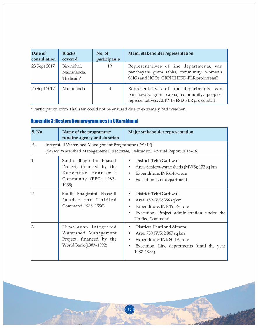
67
Date of
consultation
23 Sept 2017 Representatives of line departments, van
panchayats, gram sabha, community, women’s
SHGs and NGOs; GBPNIHESD-FLR project staff
Bironkhal,
Nainidanda,
Thalisain*
Blocks
covered
No. of
participants
Major stakeholder representation
19
25 Sept 2017 Representatives of line departments, van
panchayats, gram sabha, community, peoples'
representatives; GBPNIHESD-FLR project staff
Nainidanda 51
* Participation from Thalisain could not be ensured due to extremely bad weather.
Appendix 3: Restoration programmes in Uttarakhand
S. No.
A. Integrated Watershed Management Programme (IWMP)
(Source: Watershed Management Directorate, Dehradun, Annual Report 2015–16)
Name of the programme/
funding agency and duration
Major stakeholder representation
1. • District: Tehri Garhwal
• Area: 6 micro-watersheds (MWS); 172 sq km
• Expenditure: INR 6.46 crore
• Execution: Line department
South Bhagirathi Phase-I
Project, financed by the
E u r o p e a n E c o n o m i c
Community (EEC; 1982–
1988)
2. • District: Tehri Garhwal
• Area: 18 MWS; 356 sq km
• Expenditure: INR 19.56 crore
• Execution: Project administration under the
Unified Command
South Bhagirathi Phase-II
( u n d e r t h e U n i f i e d
Command; 1988–1996)
3. • Districts: Pauri and Almora
• Area: 75 MWS; 2,867 sq km
• Expenditure: INR 80.49 crore
• Execution: Line departments (until the year
1987–1988)
H i m a l a y a n I n t e g r a t e d
Watershed Management
Project, financed by the
World Bank (1983–1992)
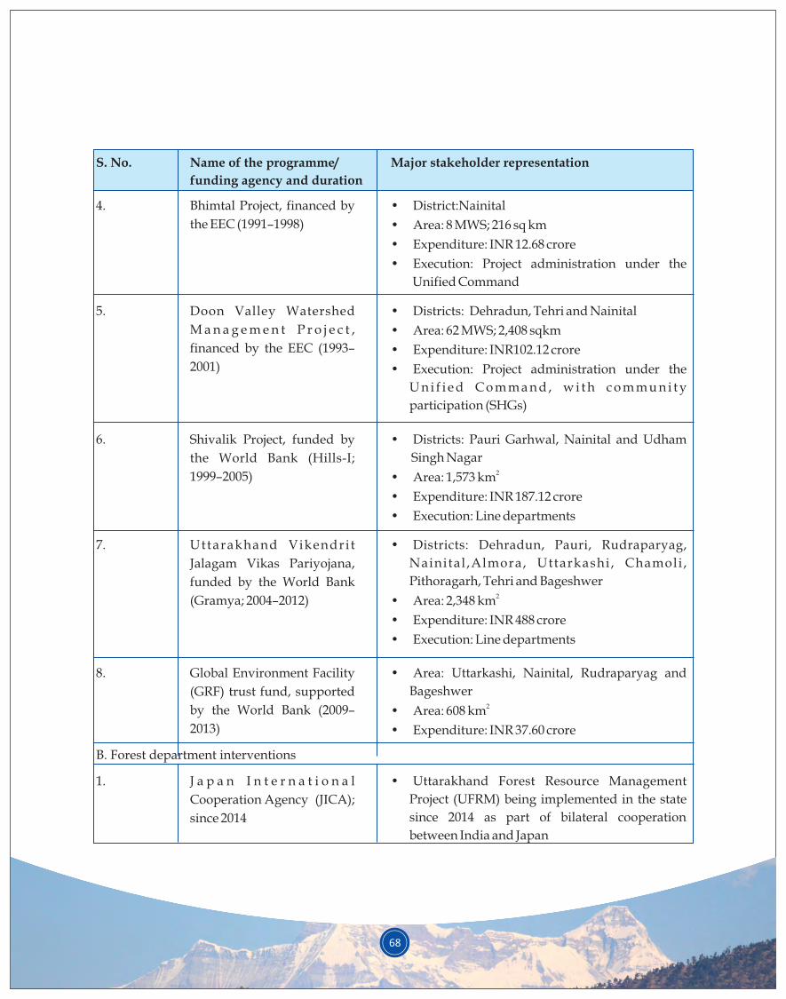
68
S. No. Major stakeholder representation
4. • District:Nainital
• Area: 8 MWS; 216 sq km
• Expenditure: INR 12.68 crore
• Execution: Project administration under the
Unified Command
Bhimtal Project, financed by
the EEC (1991–1998)
5. • Districts: Dehradun, Tehri and Nainital
• Area: 62 MWS; 2,408 sqkm
• Expenditure: INR102.12 crore
• Execution: Project administration under the
U n i f i e d C o m m a n d , w i t h c o m m u n i t y
participation (SHGs)
Doon Valley Watershed
M a n a g e m e n t P r o j e c t ,
financed by the EEC (1993–
2001)
6. • Districts: Pauri Garhwal, Nainital and Udham
Singh Nagar
• Area: 1,573 km
• Expenditure: INR 187.12 crore
• Execution: Line departments
2
Shivalik Project, funded by
the World Bank (Hills-I;
1999–2005)
7. • Districts: Dehradun, Pauri, Rudraparyag,
Nainital ,Almora, Uttarkashi , Chamoli ,
Pithoragarh, Tehri and Bageshwer
• Area: 2,348 km
• Expenditure: INR 488 crore
• Execution: Line departments
2
Uttarakhand Vikendri t
Jalagam Vikas Pariyojana,
funded by the World Bank
(Gramya; 2004–2012)
8. •
Bageshwer2• Area: 608 km
• Expenditure: INR 37.60 crore
Area: Uttarkashi, Nainital, Rudraparyag and Global Environment Facility
(GRF) trust fund, supported
by the World Bank (2009–
2013)
B. Forest department interventions
1. •
Project (UFRM) being implemented in the state
since 2014 as part of bilateral cooperation
between India and Japan
Uttarakhand Forest Resource Management J a p a n I n t e r n a t i o n a l
Cooperation Agency (JICA);
since 2014
Name of the programme/
funding agency and duration
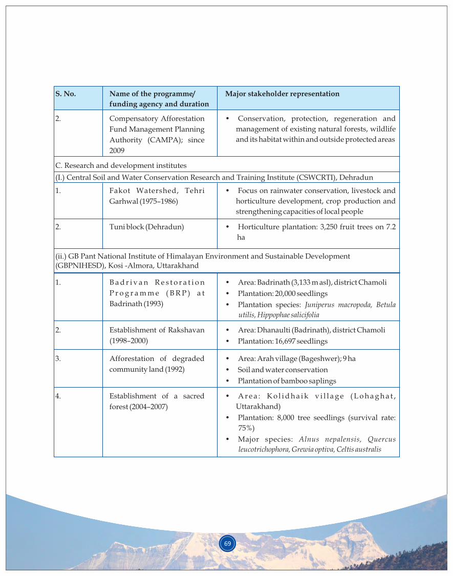
69
S. No. Major stakeholder representation
2. •
management of existing natural forests, wildlife
and its habitat within and outside protected areas
Conservation, protection, regeneration and Compensatory Afforestation
Fund Management Planning
Authority (CAMPA); since
2009
1. •
horticulture development, crop production and
strengthening capacities of local people
Focus on rainwater conservation, livestock and Fakot Watershed, Tehri
Garhwal (1975–1986)
2. •
ha
Horticulture plantation: 3,250 fruit trees on 7.2 Tuni block (Dehradun)
C. Research and development institutes
1. B a d r i v a n R e s t o r a t i o n
P r o g r a m m e ( B R P ) a t
Badrinath (1993)
(I.) Central Soil and Water Conservation Research and Training Institute (CSWCRTI), Dehradun
(ii.) GB Pant National Institute of Himalayan Environment and Sustainable Development(GBPNIHESD), Kosi -Almora, Uttarakhand
•
• Plantation: 20,000 seedlings
• Plantation species: Juniperus macropoda, Betula
utilis, Hippophae salicifolia
Area: Badrinath (3,133 m asl), district Chamoli
2. Establishment of Rakshavan
(1998–2000)
Afforestation of degraded
community land (1992)
•
• Plantation: 16,697 seedlings
Area: Dhanaulti (Badrinath), district Chamoli
3. •
• Soil and water conservation
• Plantation of bamboo saplings
Area: Arah village (Bageshwer); 9 ha
Establishment of a sacred
forest (2004–2007)
4. •
Uttarakhand)
• Plantation: 8,000 tree seedlings (survival rate:
75%)
• Major species: Alnus nepalensis, Quercus
leucotrichophora, Grewia optiva, Celtis australis
A r e a : K o l i d h a i k v i l l a g e ( L o h a g h a t ,
Name of the programme/
funding agency and duration
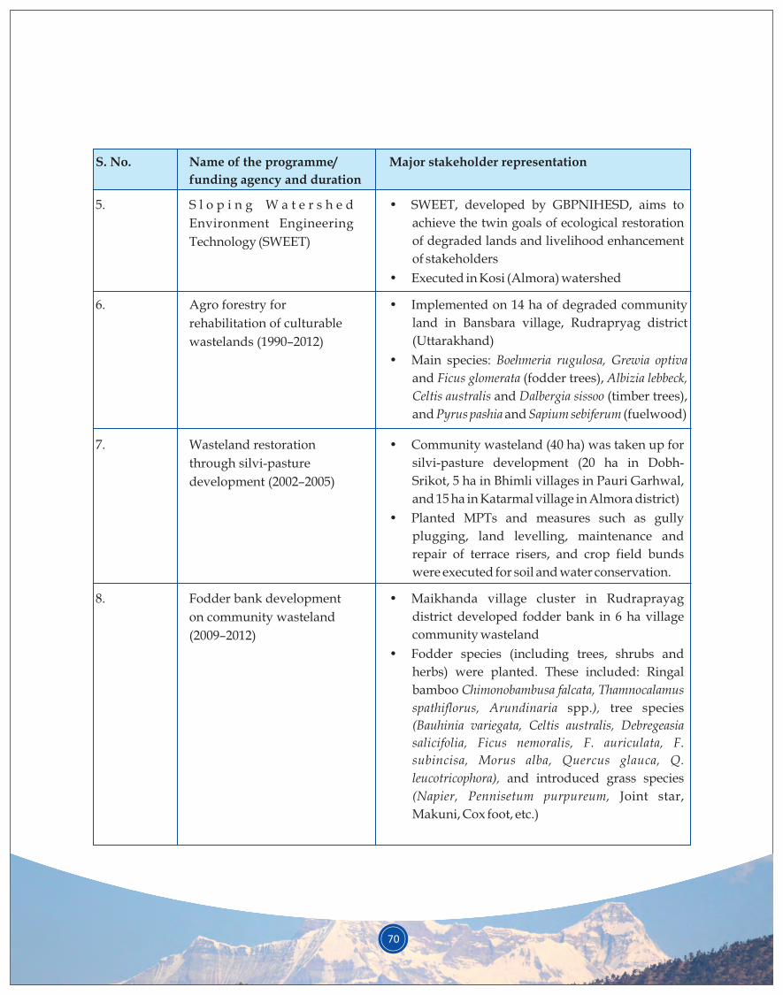
70
S. No. Major stakeholder representation
5. •
achieve the twin goals of ecological restoration
of degraded lands and livelihood enhancement
of stakeholders
• Executed in Kosi (Almora) watershed
SWEET, developed by GBPNIHESD, aims to S l o p i n g W a t e r s h e d
Environment Engineering
Technology (SWEET)
6. •
land in Bansbara village, Rudrapryag district
(Uttarakhand)
• Main species: Boehmeria rugulosa, Grewia optiva
and Ficus glomerata (fodder trees), Albizia lebbeck,
Celtis australis and Dalbergia sissoo (timber trees),
and Pyrus pashia and Sapium sebiferum (fuelwood)
Implemented on 14 ha of degraded community Agro forestry for
rehabilitation of culturable
wastelands (1990–2012)
7. •
silvi-pasture development (20 ha in Dobh-
Srikot, 5 ha in Bhimli villages in Pauri Garhwal,
and 15 ha in Katarmal village in Almora district)
• Planted MPTs and measures such as gully
plugging, land levelling, maintenance and
repair of terrace risers, and crop field bunds
were executed for soil and water conservation.
Community wasteland (40 ha) was taken up for Wasteland restoration
through silvi-pasture
development (2002–2005)
8. •
district developed fodder bank in 6 ha village
community wasteland
• Fodder species (including trees, shrubs and
herbs) were planted. These included: Ringal
bamboo Chimonobambusa falcata,
spathiflorus, Arundinaria spp.), tree species
(Bauhinia variegata, Celtis australis, Debregeasia
salicifolia, Ficus nemoralis, F. auriculata, F.
subincisa, Morus alba, Quercus glauca, Q.
leucotricophora), and introduced grass species
(Napier, Pennisetum purpureum, Joint star,
Makuni, Cox foot, etc.)
Maikhanda village cluster in Rudraprayag
Thamnocalamus
Fodder bank development
on community wasteland
(2009–2012)
Name of the programme/
funding agency and duration

71
S. No. Major stakeholder representation
9. •
employed in about 55 ha degraded community
land using four land use models (viz., multi-
p u r p o s e t r e e s p e c i e s ; S i l v i - p a s t u r e
development; Aromatic plants cultivation; and
Agri-horticulture).
• In the multi-purpose tree species model, a total
of 38,322 saplings of more than 20 MPTs were
planted; they registered 16–37% mean survival
after 5 years.
Vegetative and engineering measures were Participatory rehabilitation
of Bhimtal Lake catchment,
Nainital (2002–2010)
10. •
Plantation area: 2 ha; species: Quercus
leucotrichophora, Quercus glauca
• Majhera village van panchayat
• Plantation area: 2 ha; species: Quercus
leucotrichophora, Quercus glauca
• Chitgal village panchayat
• Plantation area: 4 ha; seedlings of oak and
Diploknema butyracea
Nakina village van panchayat (Pithoragarh) Kailash Sacred Landscape
Development Initiative,
project funded by ICIMOD
(2014–2016)
1. •
degraded land in Garhwal Himalayas
• Establishment of a germplasm bank for various
MPT species of the region
• Construction of water saving (conservation)
tanks
Demonstration of SWEET for restoration of HNB Garhwal University,
Srinagar,
Uttarakhand
(1995–1998)
(iii.) Regional universities and NGOs
Name of the programme/
funding agency and duration
2. •
• 17,000 saplings (Diploknema butyracea) planted in
38 ha area
Nursery development:Chyura in PithoragarhHimalayan Study Circle,
Pithoragarh
(1996–1999)
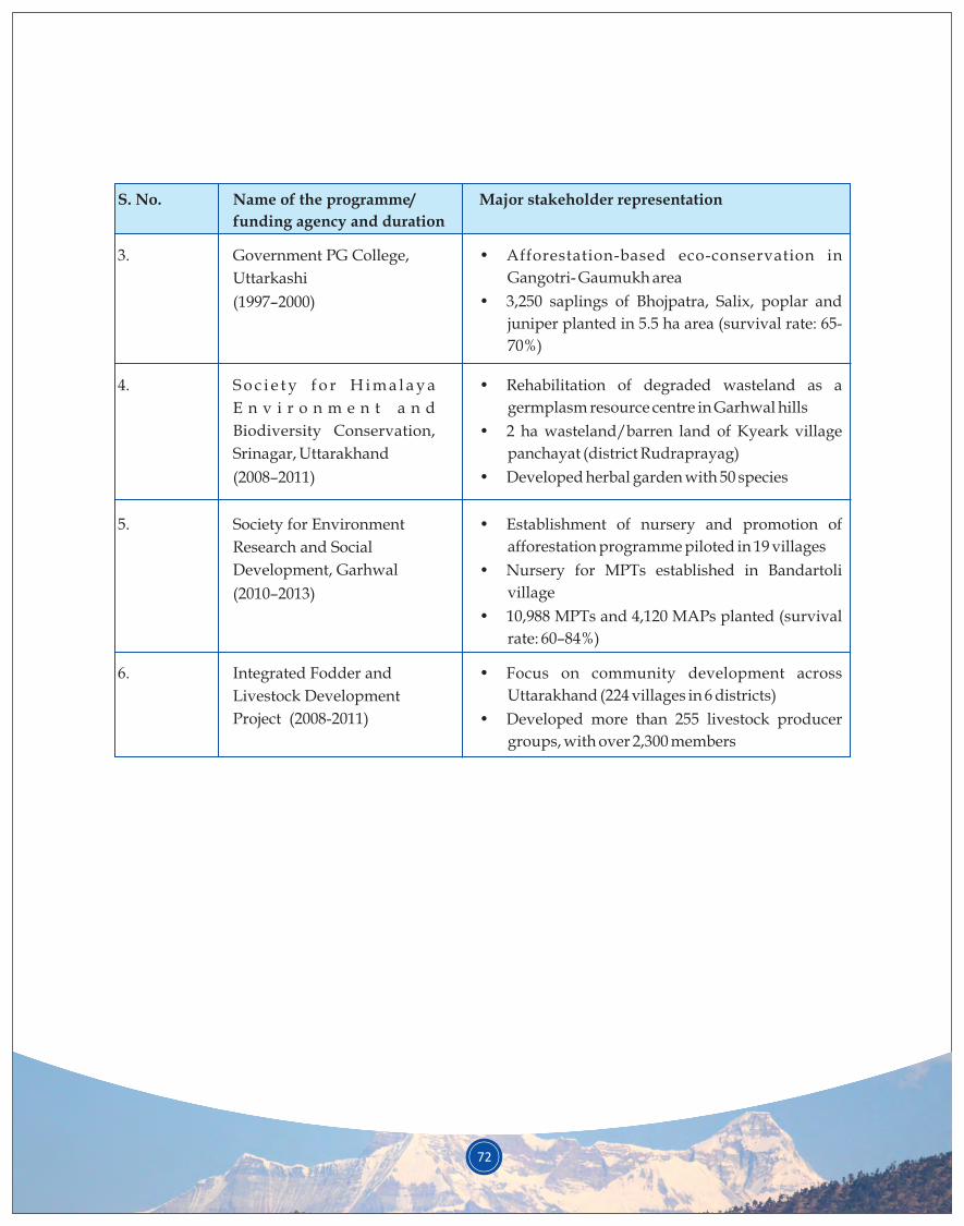
72
S. No. Major stakeholder representation
4. •
germplasm resource centre in Garhwal hills
• 2 ha wasteland/barren land of Kyeark village
panchayat (district Rudraprayag)
• Developed herbal garden with 50 species
Rehabilitation of degraded wasteland as a S o c i e t y f o r H i m a l a y a
E n v i r o n m e n t a n d
Biodiversity Conservation,
Srinagar, Uttarakhand
(2008–2011)
5. •
afforestation programme piloted in 19 villages
• Nursery for MPTs established in Bandartoli
village
• 10,988 MPTs and 4,120 MAPs planted (survival
rate: 60–84%)
Establishment of nursery and promotion of Society for Environment
Research and Social
Development, Garhwal
(2010–2013)
3. •
Gangotri- Gaumukh area
• 3,250 saplings of Bhojpatra, Salix, poplar and
juniper planted in 5.5 ha area (survival rate: 65-
70%)
Afforestation-based eco-conservation in Government PG College,
Uttarkashi
(1997–2000)
6. •
Uttarakhand (224 villages in 6 districts)
• Developed more than 255 livestock producer
groups, with over 2,300 members
Focus on community development across Integrated Fodder and
Livestock Development
Project (2008-2011)
Name of the programme/
funding agency and duration
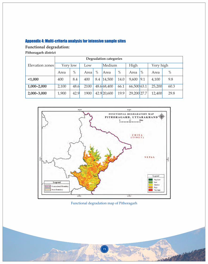
73
Appendix 4: Multi-criteria analysis for intensive sample sites
Functional degradation:
Pithoragarh district
Degradation categories
Elevation zones Very low Low Medium High Very high
Area % Area % Area % Area % Area %
<1,000 400 8.4 400 8.4 14,500 14.0 9,600 9.1 4,100 9.8
1,000–2,000 2,100 48.6 2100 48.6 68,400 66.1 66,500 63.1 25,200 60.3
2,000–3,000 1,900 42.9 1900 42.9 20,600 19.9 29,200 27.7 12,400 29.8
Functional degradation map of Pithoragarh
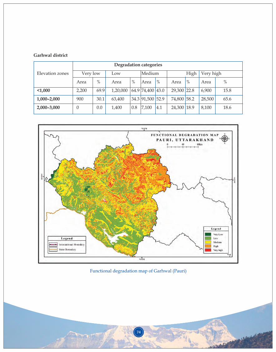
74
Garhwal district
Degradation categories
Elevation zones Very low Low Medium High Very high
Area % Area % Area % Area % Area %
<1,000 2,200 69.9 1,20,000 64.9 74,400 43.0 29,300 22.8 6,900 15.8
1,000–2,000 900 30.1 63,400 34.3 91,500 52.9 74,800 58.2 28,500 65.6
2,000–3,000 0 0.0 1,400 0.8 7,100 4.1 24,300 18.9 8,100 18.6
Functional degradation map of Garhwal (Pauri)
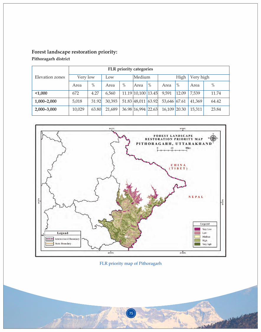
75
Forest landscape restoration priority:
Pithoragarh district
FLR priority categories
Elevation zones Very low Low Medium High Very high
Area % Area % Area % Area % Area %
<1,000 672 4.27 6,560 11.19 10,100 13.45 9,591 12.09 7,539 11.74
1,000–2,000 5,018 31.92 30,393 51.83 48,011 63.92 53,646 67.61 41,369 64.42
2,000–3,000 10,029 63.80 21,689 36.98 16,994 22.63 16,109 20.30 15,311 23.84
FLR priority map of Pithoragarh
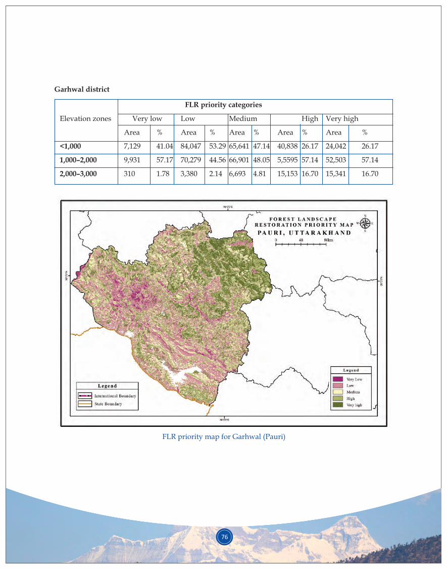
76
Garhwal district
FLR priority categories
Elevation zones Very low Low Medium High Very high
Area % Area % Area % Area % Area %
<1,000 7,129 41.04 84,047 53.29 65,641 47.14 40,838 26.17 24,042 26.17
1,000–2,000 9,931 57.17 70,279 44.56 66,901 48.05 5,5595 57.14 52,503 57.14
2,000–3,000 310 1.78 3,380 2.14 6,693 4.81 15,153 16.70 15,341 16.70
FLR priority map for Garhwal (Pauri)
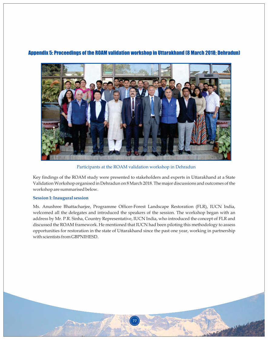
77
Appendix 5: Proceedings of the ROAM validation workshop in Uttarakhand (8 March 2018; Dehradun)
Participants at the ROAM validation workshop in Dehradun
Key findings of the ROAM study were presented to stakeholders and experts in Uttarakhand at a State
Validation Workshop organised in Dehradun on 8 March 2018. The major discussions and outcomes of the
workshop are summarised below.
Ms. Anushree Bhattacharjee, Programme Officer-Forest Landscape Restoration (FLR), IUCN India,
welcomed all the delegates and introduced the speakers of the session. The workshop began with an
address by Mr. P.R. Sinha, Country Representative, IUCN India, who introduced the concept of FLR and
discussed the ROAM framework. He mentioned that IUCN had been piloting this methodology to assess
opportunities for restoration in the state of Uttarakhand since the past one year, working in partnership
with scientists from GBPNIHESD.
Session 1: Inaugural session
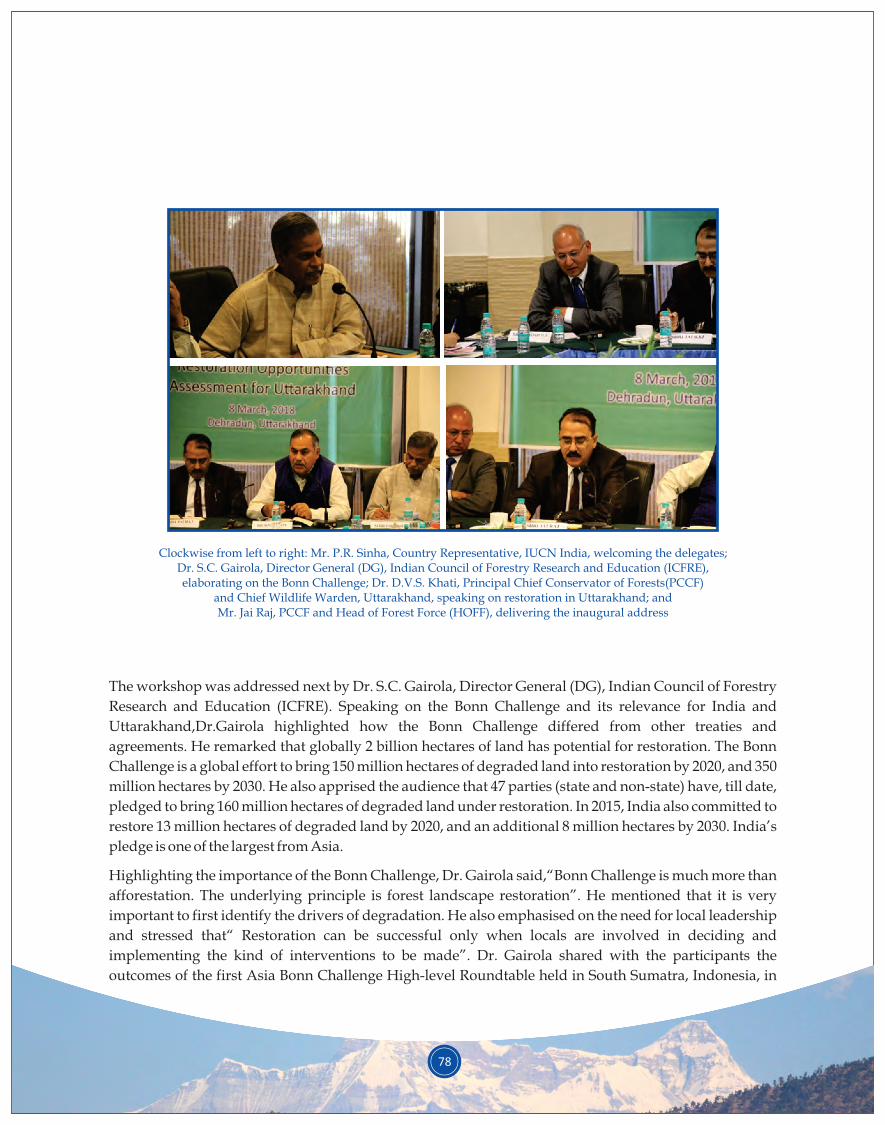
78
Clockwise from left to right: Mr. P.R. Sinha, Country Representative, IUCN India, welcoming the delegates; Dr. S.C. Gairola, Director General (DG), Indian Council of Forestry Research and Education (ICFRE), elaborating on the Bonn Challenge; Dr. D.V.S. Khati, Principal Chief Conservator of Forests(PCCF)
and Chief Wildlife Warden, Uttarakhand, speaking on restoration in Uttarakhand; and Mr. Jai Raj, PCCF and Head of Forest Force (HOFF), delivering the inaugural address
The workshop was addressed next by Dr. S.C. Gairola, Director General (DG), Indian Council of Forestry
Research and Education (ICFRE). Speaking on the Bonn Challenge and its relevance for India and
Uttarakhand,Dr.Gairola highlighted how the Bonn Challenge differed from other treaties and
agreements. He remarked that globally 2 billion hectares of land has potential for restoration. The Bonn
Challenge is a global effort to bring 150 million hectares of degraded land into restoration by 2020, and 350
million hectares by 2030. He also apprised the audience that 47 parties (state and non-state) have, till date,
pledged to bring 160 million hectares of degraded land under restoration. In 2015, India also committed to
restore 13 million hectares of degraded land by 2020, and an additional 8 million hectares by 2030. India’s
pledge is one of the largest from Asia.
Highlighting the importance of the Bonn Challenge, Dr. Gairola said,“Bonn Challenge is much more than
afforestation. The underlying principle is forest landscape restoration”. He mentioned that it is very
important to first identify the drivers of degradation. He also emphasised on the need for local leadership
and stressed that“ Restoration can be successful only when locals are involved in deciding and
implementing the kind of interventions to be made”. Dr. Gairola shared with the participants the
outcomes of the first Asia Bonn Challenge High-level Roundtable held in South Sumatra, Indonesia, in

79
May 2017; it was aimed at developing strategies for Asian countries to meet their restoration targets. He
also mentioned the South Asia Regional Consultation on Forest Landscape Restoration and Bonn
Challenge that was held at New Delhi in August 2017. Dr. Gairola emphasised the need for a proper
roadmap towards the achievement of the Bonn Challenge. In conclusion, he complimented IUCN for
initiating the first step towards developing a restoration roadmap for the state of Uttarakhand. “It is
important to involve the policymakers right from the beginning”, he said and remarked,“What IUCN has
begun is a tough task as it involves so many contradictions… the experience gained during this process in
Uttarakhand can help drive the process in other states as well”.
In his opening remarks,Dr. D.V.S Khati, Principal Chief Conservator of Forest (PCCF) - Wildlife and Chief
Wildlife Warden (CWW), Uttarakhand, complimented IUCN for completing the project within a year. He
spoke of the relationship between forest restoration and spring revival in Uttarakhand. Dr. Khati
underlined the need for involving locals in restoration efforts stating,“Associating people in the process of
restoration will give fruitful results”. He stressed the importance of going with the natural way of
restoration and people’s way of restoration and of linking restoration with watersheds. He mentioned that
plantations in the hills often fail because the pits dug for plantations cause slope erosion. Thus, it is crucial
to adopt natural regeneration as a strategy for restoration in the hills wherever possible rather than going
for artificial regeneration.
Mr. Jai Raj, PCCF and Head of Forest Force (HOFF), said that the biggest challenge facing the country
today was harmonising economic development and conservation of nature. He felt that often it was a
losing battle for conservation and restoration. Congratulating IUCN for the initiative taken in the state of
Uttarakhand, he remarked that it would be useful only “when the initiative is transformed into a
finitiative”, by which he meant that the initiative for conservation and restoration needs to reach the finish
line. Mr. Jai Raj pointed out that assisted natural regeneration had worked well in Uttarakhand, and
plantation in the Terai region had demonstrated 95% success rate. Thus, it is important to have strategies
as per the suitability of the region. Mr. Jai Raj also stressed on the importance of involving local
communities and civil societies in the process from the very beginning. He mentioned how civil societies
are stronger in other countries, compared to India, and referred to Japan as a good example of
development and community involvement. He felt that improving public awareness was a slow process
in India. Similarly, there was often a lack of finances and resources for the environment. Public opinion
could hopefully help drive real action and appropriate allocation of resources. Mr. Jai Raj also focussed on
the idea of sustainable development. The idea is to take a landscape approach, taking into consideration
the aspirations of the local people and the ability of the land to provide various goods and services; such an
approach will take into account the ecological, social, and economic aspects. Mr. Jai Raj said that once an
indication of the financial resources required for the project is shared with the government, the state could
also look at the resources available under Green India Mission (GIM) and National Mission for Clean
Ganga (NMCG) etc. to ensure implementation and monitoring of the restoration activities. He ended his
address by saying,“Let us build public opinion for conserving nature and supporting the departments”.
The inaugural session was brought to a close by a vote of thanks by Ms. Bhattacharjee, IUCN India.
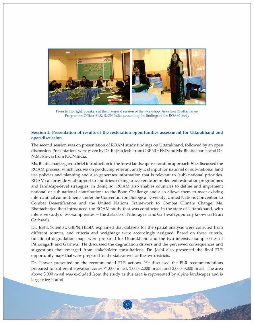
80
From left to right: Speakers at the inaugural session of the workshop; Anushree Bhattacharjee, Programme Officer-FLR, IUCN India, presenting the findings of the ROAM study
Session 2: Presentation of results of the restoration opportunities assessment for Uttarakhand and
open discussion
The second session was on presentation of ROAM study findings on Uttarakhand, followed by an open
discussion. Presentations were given by Dr. Rajesh Joshi from GBPNIHESD and Ms. Bhattacharjee and Dr.
N.M. Ishwar from IUCN India.
Ms. Bhattacharjee gave a brief introduction to the forest landscape restoration approach. She discussed the
ROAM process, which focuses on producing relevant analytical input for national or sub-national land
use policies and planning and also generates information that is relevant to (sub) national priorities.
ROAM can provide vital support to countries seeking to accelerate or implement restoration programmes
and landscape-level strategies. In doing so, ROAM also enables countries to define and implement
national or sub-national contributions to the Bonn Challenge and also allows them to meet existing
international commitments under the Convention on Biological Diversity, United Nations Convention to
Combat Desertification and the United Nations Framework to Combat Climate Change. Ms.
Bhattacharjee then introduced the ROAM study that was conducted in the state of Uttarakhand, with
intensive study of two sample sites — the districts of Pithoragarh and Garhwal (popularly known as Pauri
Garhwal).
Dr. Joshi, Scientist, GBPNIHESD, explained that datasets for the spatial analysis were collected from
different sources, and criteria and weightage were accordingly assigned. Based on these criteria,
functional degradation maps were prepared for Uttarakhand and the two intensive sample sites of
Pithoragarh and Garhwal. He discussed the degradation drivers and the perceived consequences and
suggestions that emerged from stakeholder consultations. Dr. Joshi also presented the final FLR
opportunity maps that were prepared for the state as well as the two districts.
Dr. Ishwar presented on the recommended FLR actions. He discussed the FLR recommendations
prepared for different elevation zones:<1,000 m asl, 1,000–2,000 m asl, and 2,000–3,000 m asl. The area
above 3,000 m asl was excluded from the study as this area is represented by alpine landscapes and is
largely ice-bound.
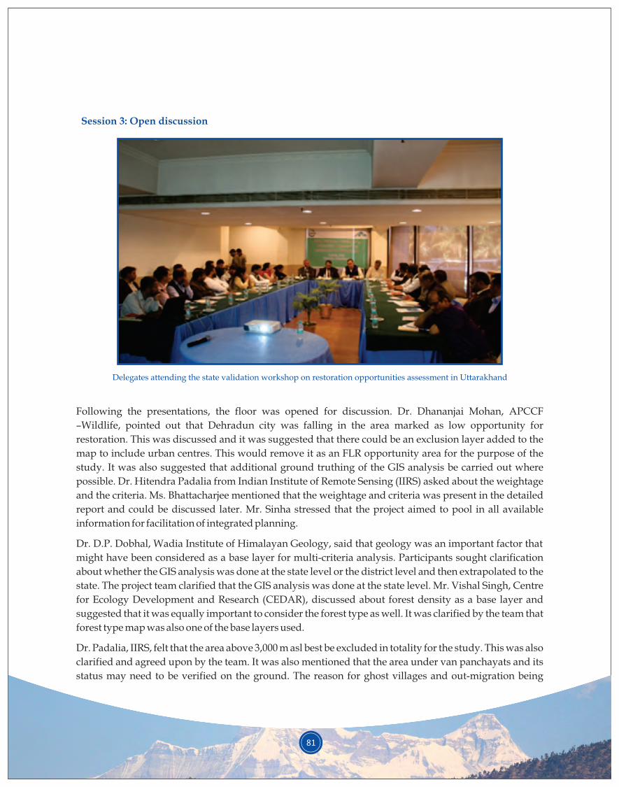
81
Delegates attending the state validation workshop on restoration opportunities assessment in Uttarakhand
Following the presentations, the floor was opened for discussion. Dr. Dhananjai Mohan, APCCF
–Wildlife, pointed out that Dehradun city was falling in the area marked as low opportunity for
restoration. This was discussed and it was suggested that there could be an exclusion layer added to the
map to include urban centres. This would remove it as an FLR opportunity area for the purpose of the
study. It was also suggested that additional ground truthing of the GIS analysis be carried out where
possible. Dr. Hitendra Padalia from Indian Institute of Remote Sensing (IIRS) asked about the weightage
and the criteria. Ms. Bhattacharjee mentioned that the weightage and criteria was present in the detailed
report and could be discussed later. Mr. Sinha stressed that the project aimed to pool in all available
information for facilitation of integrated planning.
Dr. D.P. Dobhal, Wadia Institute of Himalayan Geology, said that geology was an important factor that
might have been considered as a base layer for multi-criteria analysis. Participants sought clarification
about whether the GIS analysis was done at the state level or the district level and then extrapolated to the
state. The project team clarified that the GIS analysis was done at the state level. Mr. Vishal Singh, Centre
for Ecology Development and Research (CEDAR), discussed about forest density as a base layer and
suggested that it was equally important to consider the forest type as well. It was clarified by the team that
forest type map was also one of the base layers used.
Dr. Padalia, IIRS, felt that the area above 3,000 m asl best be excluded in totality for the study. This was also
clarified and agreed upon by the team. It was also mentioned that the area under van panchayats and its
status may need to be verified on the ground. The reason for ghost villages and out-migration being
Session 3: Open discussion
82
caused by degradation needed to be examined further, as the delegates felt that degradation was not the
only reason for cropland abandonment.
Dr. Neena Grewal, Project Director, Watershed Management Directorate (WMD), said that often there
was over-exploitation of water and excessive tapping near the source by various departments. It was also
discussed that heavy road construction was a major cause for water loss and degradation. Many
participants spoke of the improvement in forest landscapes since the penetration of LPG in the state. Mr.
Singh, CEDAR, said that it would be interesting to see the effects of climate change on the identified
degraded patches. Dr. Mohan, APCCF, stressed on the importance of checking the perceptions about
forest fires and human-wildlife conflict and cross-checking that with the existing data from the
department as well as from satellite imagery. Community perceptions needed to be revalidated through
science wherever possible, he emphasised. Dr. V.P. Uniyal, Wildlife Institute of India (WII), spoke about
forest fires sometimes being beneficial for the quality of the forest.
Mr. Subrato Paul, UNDP, enquired about the slope and aspect layers used. The team clarified that all of
these were used as base layers for creation of final maps. Ms. Grewal, WMD, mentioned that Forest
Research Institute (FRI) had carried out a socio-economic assessment of forests in India last year, and its
report would be useful for the ROAM study. Dr. Padalia, IIRS, said that a review of the different ROAM
processes across different countries and their levels of success would help to better inform the audience.
He also felt that temperature could be considered as a factor in the biophysical base maps. On the socio-
economic side, he felt that literacy, road network and household water availability could be important
factors. Interpretation of degradation can be quite tricky. Temporal data on fires is also available on the
Bhuwan website, and it may be utilised for the study. He spoke of the need to have consistency in giving
weightage to criteria. The approach needs to be opened up so that there is transparency. The IUCN team
clarified that the weightage and criteria could be discussed with the participants, and reemphasised that
ROAM is a very adaptable and flexible framework.
Mr. Singh, CEDAR, mentioned that degradation in the Himalayas is very different from other regions. He
mentioned that CEDAR has long-term monitoring plots, and findings from that exercise could be quite
useful for the ROAM study. The project team thanked him and requested that he share the data with them.
Dr. Gajendra Singh, Uttarakhand Space Application Centre (USAC), stressed that in cases of landslides
and forest fires, it was important to see the extent of the area that was directly affected. He spoke of the
need to create accurate GIS layers, staying neutral while creating the GIS layers and avoiding bias. Ms.
Grewal, WMD, spoke of the budget of the Planning Commission of the Uttarakhand government. It
would be good to refer to that document, as the government is linking the budget to SDGs, and land
degradation was also being considered.
Dr. Manoj Chandran, Chief Conservator of Forests (CCF), congratulated the IUCN-GBPNIHESD team for
the tough task completed by the team. He suggested that the definition of restoration as well as
degradation be very clearly stated right at the beginning. He stressed that all the assumptions needed to be
validated either through literature review or through a methodology. Dr. Chandran stressed that the
stakeholder perceptions be supported through validation. The age group and knowledge level of the
stakeholders was an important factor to be considered, and he stressed that all stakeholders be engaged.
83
Dr. Chandran remarked that,“Once the perception of stakeholders is validated through a methodology it
becomes science”.
Dr. Vinay Bhargav, Divisional Forest Officer(DFO) - Pithoragarh, spoke of the need to give water a priority
in the analysis and mentioned that community participation would be of great importance in forest fire
management. He mentioned that this was the first time an integrated approach was undertaken in the
district, and he congratulated the team for making this possible.
The open discussion session was then brought to a close with Ms. Bhattacharjee, IUCN India, thanking all
the delegates for sharing their valuable feedback.
Dr. Mohan, APCCF, remarked,“It is a nice initiative to look at degradation in a holistic manner”. He said
that he looked at the entire project as a great opportunity. He lauded the project for achieving the first
crucial step of convergence of information. He felt that convergence of action was something that was very
tricky and perhaps beyond the mandate of the project. Dr. Mohan suggested development of criteria
based on objectives; defining these accordingly would help in coming up with good results. He felt that
satellite interpretations needed to be supported by ground truthing. He suggested that the project should
take up the feedback and comments that were feasible within the life cycle of the project. He again
congratulated the IUCN-GBPNIHESD team on completing the project within a year and delivering its
results.
Mr. Sinha, IUCN India, said that the important thing was the macro picture that had emerged, based on
which decisions can be taken. He said,“Opportunity map is a practical suggestion to move forward”. He
also thanked everyone for their suggestions and feedback, and hoped that the suggestions will help to
make macro-level decision at the state level and some micro-level decisions at the district level.
Dr. Joshi, GBPNIHESD, gave the vote of thanks, acknowledging the contribution everyone present had
made by providing their valuable suggestions and to make workshop a success.
Session 4: Closing session
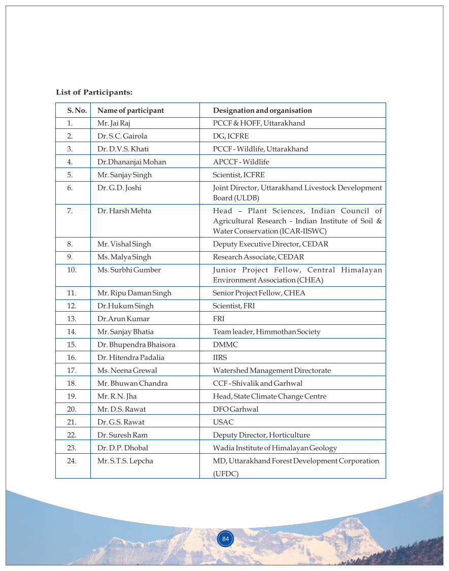
84
List of Participants:
S. No. Name of participant Designation and organisation
1. Mr. Jai Raj PCCF & HOFF, Uttarakhand
2. Dr. S.C. Gairola DG, ICFRE
3. Dr. D.V.S. Khati PCCF - Wildlife, Uttarakhand
4. Dr.Dhananjai Mohan APCCF - Wildlife
5. Mr. Sanjay Singh Scientist, ICFRE
6. Dr. G.D. Joshi Joint Director, Uttarakhand Livestock Development
Board (ULDB)
7. Dr. Harsh Mehta Head – Plant Sciences, Indian Council of
Agricultural Research - Indian Institute of Soil &
Water Conservation (ICAR-IISWC)
8. Mr. Vishal Singh Deputy Executive Director, CEDAR
9. Ms. Malya Singh Research Associate, CEDAR
10. Ms. Surbhi Gumber Junior Project Fellow, Central Himalayan
Environment Association (CHEA)
11. Mr. Ripu Daman Singh Senior Project Fellow, CHEA
12. Dr.Hukum Singh Scientist, FRI
13. Dr.Arun Kumar FRI
14. Mr. Sanjay Bhatia Team leader, Himmothan Society
15. Dr. Bhupendra Bhaisora DMMC
16. Dr. Hitendra Padalia IIRS
17. Ms. Neena Grewal Watershed Management Directorate
18. Mr. Bhuwan Chandra CCF - Shivalik and Garhwal
19. Mr. R.N. Jha Head, State Climate Change Centre
20. Mr. D.S. Rawat DFO Garhwal
21. Dr. G.S. Rawat USAC
22. Dr. Suresh Ram Deputy Director, Horticulture
23. Dr. D.P. Dhobal Wadia Institute of Himalayan Geology
24. Mr. S.T.S. Lepcha MD, Uttarakhand Forest Development Corporation
(UFDC)
25. Dr. V.R. Bhargav DFO, Pithoragarh
26. Dr. Manoj Chandran CCF, Uttarakhand Forest Department (UKFD) HQ
27. Dr. V.P. Uniyal WII
28. Mr. Manish Bhardwaj Maxwell Hospital
29. Mr. Subrato Paul UNDP
30. Dr. Rajesh Joshi GBPNIHESD
31. Mr. L.M. Kaul Research Officer, Uttarakhand Biodiversity Board
32. Mr. Ravi Pathak GBPNIHESD
33. Mr. Amit Bahukhandi GBPNIHESD
34. Mr. P.R. Sinha IUCN
35. Mr. Vishnu Sharma IUCN
36. Ms. Manpreet Kaur IUCN
37. Ms. Anushree Bhattacharjee IUCN
38. Dr. N.M. Ishwar IUCN
85
© Anushree Bhattacharjee

IUCN INTERNATIONAL UNIONFOR CONSERVATION OF NATURE
India Country OfficeC-10, Gulmohar Park,New Delhi – 110049IndiaTelefax: +91 11 2652 7742www.iucn.org/india