Assessing and Prioritizing Ecological Communities for Monitoring...
15
Assessing and Prioritizing Ecological Communities for Monitoring in a Regional Habitat Conservation Plan Lauren A. Hierl Janet Franklin Douglas H. Deutschman Helen M. Regan Brenda S. Johnson Received: 22 August 2007 / Accepted: 29 February 2008 / Published online: 10 April 2008 Ó Springer Science+Business Media, LLC 2008 Abstract In nature reserves and habitat conservation areas, monitoring is required to determine if reserves are meeting their goals for preserving species, ecological communities, and ecosystems. Increasingly, reserves are established to protect multiple species and communities, each with their own conservation goals and objectives. As resources are always inadequate to monitor all components, criteria must be applied to prioritize both species and communities for monitoring and management. While methods for prioritizing species based on endangerment or risk have been established, approaches to prioritizing eco- logical communities for monitoring are not well developed, despite a long-standing emphasis on communities as target elements in reserve design. We established guidelines based on four criteria derived from basic principles of conserva- tion and landscape ecology—extent, representativeness, fragmentation, and endangerment—to prioritize communi- ties in the San Diego Multiple Species Conservation Plan (MSCP). The MSCP was one of the first multiple-species habitat conservation areas established in California, USA, and it has a complex spatial configuration because of the patterns of surrounding land use, which are largely urbanized. In this case study, high priority communities for monitoring include coastal sage scrub (high endangerment, underrepresented within the reserve relative to the region, and moderately fragmented), freshwater wetlands, and coastal habitats (both have high fragmentation, moderate endangerment and representativeness, and low areal extent). This framework may be useful to other conserva- tion planners and land managers for prioritizing the most significant and at-risk communities for monitoring. Keywords Biodiversity Á Endangerment Á Fragmentation Á Multispecies Á Representativeness Á Reserve Á Protected area It is fundamental to conservation biology that preserving species and ecological processes requires protecting the space that they occupy. Identification of geographical gaps in biodiversity protection (Davis and others 1995; Scott and others 1993) and design of nature reserves or protected areas (Margules and Pressey 2000; Possingham and others 2006) have frequently targeted both species and ecosys- tems for conservation (Noss 1990), commonly referred to as fine and coarse filters (Noss 1987). When species are the focus of reserve design or management actions, those at high risk of extinction or extirpation are often given greatest priority. Species and speciation are typically the ultimate targets of biodiversity protection (Wilson 1992). However, ecosystems—ecological communities and their physical habitat—by definition comprise all species in a community, not just rare ones, and provide habitat for constituent species. Thus, they are used as elements in gap analysis and reserve design. A specific kind of protected area, the Habitat Conser- vation Plan (HCP), is increasingly being implemented in L. A. Hierl Á J. Franklin (&) Á D. H. Deutschman Á H. M. Regan Department of Biology, San Diego State University, 5500 Campanile Drive, San Diego, CA 92182-4614, USA e-mail: [email protected] B. S. Johnson California Department of Fish and Game, Habitat Conservation Branch, 1416 Ninth Street, 12th Floor, Sacramento, CA 96814, USA Present Address: H. M. Regan Department of Biology, University of California, Riverside, CA 92521, USA 123 Environmental Management (2008) 42:165–179 DOI 10.1007/s00267-008-9109-3
-
Upload
vuongkhanh -
Category
Documents
-
view
224 -
download
3
Transcript of Assessing and Prioritizing Ecological Communities for Monitoring...

Assessing and Prioritizing Ecological Communitiesfor Monitoring in a Regional Habitat Conservation Plan
Lauren A. Hierl Æ Janet Franklin Æ Douglas H. Deutschman ÆHelen M. Regan Æ Brenda S. Johnson
Received: 22 August 2007 / Accepted: 29 February 2008 / Published online: 10 April 2008
� Springer Science+Business Media, LLC 2008
Abstract In nature reserves and habitat conservation
areas, monitoring is required to determine if reserves are
meeting their goals for preserving species, ecological
communities, and ecosystems. Increasingly, reserves are
established to protect multiple species and communities,
each with their own conservation goals and objectives. As
resources are always inadequate to monitor all components,
criteria must be applied to prioritize both species and
communities for monitoring and management. While
methods for prioritizing species based on endangerment or
risk have been established, approaches to prioritizing eco-
logical communities for monitoring are not well developed,
despite a long-standing emphasis on communities as target
elements in reserve design. We established guidelines based
on four criteria derived from basic principles of conserva-
tion and landscape ecology—extent, representativeness,
fragmentation, and endangerment—to prioritize communi-
ties in the San Diego Multiple Species Conservation Plan
(MSCP). The MSCP was one of the first multiple-species
habitat conservation areas established in California, USA,
and it has a complex spatial configuration because of the
patterns of surrounding land use, which are largely
urbanized. In this case study, high priority communities for
monitoring include coastal sage scrub (high endangerment,
underrepresented within the reserve relative to the region,
and moderately fragmented), freshwater wetlands, and
coastal habitats (both have high fragmentation, moderate
endangerment and representativeness, and low areal
extent). This framework may be useful to other conserva-
tion planners and land managers for prioritizing the most
significant and at-risk communities for monitoring.
Keywords Biodiversity � Endangerment �Fragmentation � Multispecies � Representativeness �Reserve � Protected area
It is fundamental to conservation biology that preserving
species and ecological processes requires protecting the
space that they occupy. Identification of geographical gaps
in biodiversity protection (Davis and others 1995; Scott
and others 1993) and design of nature reserves or protected
areas (Margules and Pressey 2000; Possingham and others
2006) have frequently targeted both species and ecosys-
tems for conservation (Noss 1990), commonly referred to
as fine and coarse filters (Noss 1987). When species are the
focus of reserve design or management actions, those at
high risk of extinction or extirpation are often given
greatest priority. Species and speciation are typically the
ultimate targets of biodiversity protection (Wilson 1992).
However, ecosystems—ecological communities and their
physical habitat—by definition comprise all species in a
community, not just rare ones, and provide habitat for
constituent species. Thus, they are used as elements in gap
analysis and reserve design.
A specific kind of protected area, the Habitat Conser-
vation Plan (HCP), is increasingly being implemented in
L. A. Hierl � J. Franklin (&) � D. H. Deutschman � H. M. Regan
Department of Biology, San Diego State University, 5500
Campanile Drive, San Diego, CA 92182-4614, USA
e-mail: [email protected]
B. S. Johnson
California Department of Fish and Game, Habitat Conservation
Branch, 1416 Ninth Street, 12th Floor, Sacramento, CA 96814,
USA
Present Address:
H. M. Regan
Department of Biology, University of California, Riverside, CA
92521, USA
123
Environmental Management (2008) 42:165–179
DOI 10.1007/s00267-008-9109-3

the United States (Rahn and others 2006). Approved at the
federal level under the U.S. Endangered Species Act
(ESA), multiple-species HCPs are being promoted over
single-species HCPs because they encourage integrated
ecosystem management and can potentially protect entire
suites of species before they warrant listing under the ESA.
These are features presumed to improve the conservation
value of these plans (Franklin 1993; U.S. Fish and Wildlife
Service 1996). The number of HCPs that cover multiple
species has increased steadily over time. As of January
2007, 484 HCPs were permitted across the United States,
40 of which cover 10 or more species (U.S. Fish and
Wildlife Service 2007). Because of their growing preva-
lence there is substantial interest in how to monitor the
success of multispecies HCPs.
While traditional HCPs were designed to manage and
preserve habitat for a single-species, multispecies HCPs are
intended to conserve both target species and broad-level
ecosystem components and processes. Conservation of
ecological communities is in fact mandated in California’s
Natural Community Conservation Planning Act (California
Department of Fish and Game 2003), which oversees a
statewide program of multispecies HCPs. Communities are
thus a second element of biodiversity, along with covered
species, with specific conservation targets. Ecological
communities provide habitat for targeted species but are also
valuable monitoring elements because they can be used as a
gauge of ecosystem function and diversity (Jewell 2000).
Much of the literature on landscape-scale conservation
has focused on methods of optimal reserve design
(Margules and others 1988; Pressey and others 1999; Wilson
and others 2006). However, successful conservation requires
more than establishing an optimally designed reserve. Long-
term management and monitoring are crucial to determining
if species and communities are actually being protected in
the reserve, particularly given the high level of landscape
fragmentation found in many regions (Barrows and others
2005; Scott and others 2005). In addition to biologically
sound reserve design and land acquisition, a conservation
program needs a baseline inventory, clearly defined goals
and objectives, conceptual models to assist in collating
knowledge and understanding ecosystems, and a manage-
ment and monitoring plan for covered species and
communities (Atkinson and others 2004; Mulder and others
1999). Community monitoring in this context typically
assesses ecological condition, including diversity and func-
tion. Monitoring as part of an adaptive management
framework should identify when management interventions
may be needed and monitor the success of those interven-
tions at achieving previously defined conservation goals.
Unfortunately, resources are often inadequate to monitor
all covered species and all ecological communities to the
same degree, so it is necessary to prioritize elements that
should be the primary focus of monitoring efforts. Formal
prioritization techniques have been developed for at-risk
species (Andelman and others 2004; Purvis and others
2000), and some studies have classified at-risk communi-
ties for conservation planning purposes (Noss 1996;
Rodriguez and others 2007). However, we found few
published methods specifically aimed at prioritizing com-
munities for monitoring (Nicholson and Wilcove 2007). In
addition, reserves may be assembled over a period of
decades, and the final footprint of the reserve may be
somewhat different from that envisioned in the original
plan. Given the incremental nature of land acquisition, it
may also be important to assess the extent and configura-
tion of communities incorporated into the reserve to
determine if the plan’s original targets have been met.
The San Diego Multiple Species Conservation Plan
(MSCP) established an almost 52,000-ha reserve within an
approximately 2300-km2 region in southwestern San Diego
County (Fig. 1). The region has high biological diversity and
a varied landscape spanning mountains to coastal strand.
Southern California has been designated a biodiversity
‘‘hotspot’’ (Brooks and others 2002; Medail and Quezel
1999; Myers and others 2000; Rubinoff 2001) and the large
number of endemic and rare species that occur there are at
considerable risk of habitat loss owing to high levels of
human population growth and pressure for land develop-
ment (e.g., Shearer and others 2006). Approved in 1997, the
MSCP was one of the first multispecies HCPs designated in
California under the state’s Natural Community Conserva-
tion Planning (NCCP) program, and it was viewed as ‘‘a
major milestone in America’s conservation history and a
model plan for communities nationwide’’ (U.S. Department
of Interior Secretary, Bruce Babbitt; quoted in Hanna 1997).
In addition to covering 85 endangered, threatened, and rare
plant and animal species, the San Diego MSCP aims to
protect a variety of ecological communities, including
coastal sage scrub, its flagship plant community.
In this paper we develop a comprehensive approach to
assessing and prioritizing ecological communities within a
biodiversity reserve at the landscape scale which we apply to
the San Diego MSCP. Our specific objectives in this paper are
(1) to assess the extent and configuration of the San Diego
MSCP reserve’s land acquisition in light of the original tar-
gets set in its reserve design process and (2) to apply a
framework to prioritize ecological communities for moni-
toring that relies on landscape pattern analysis and published
community endangerment rankings. This framework, used to
prioritize the most at-risk communities for monitoring, may
be useful to other conservation planners and land managers.
This study focuses specifically on ecological communities
themselves as conservation elements. In a separate study we
address habitat requirements of covered species vis-a-vis
these community types (Regan and others 2008).
166 Environmental Management (2008) 42:165–179
123

Materials and Methods
Study Area and Data
Located in the southwestern corner of San Diego County,
California, USA (Fig. 1), the San Diego MSCP reserve
includes lands in the City of San Diego and 11 other
jurisdictions. The region is bordered by Mexico to the
south, the Pacific Ocean to the west, U.S. National Forest
Service lands to the east, and the San Dieguito River
Valley to the north (Greer 2004). The two dominant
community types in the region are coastal sage scrub and
chaparral, but communities range from coastal types (e.g.,
beaches, salt pans, bluffs) to grasslands, oak woodlands,
riparian areas, and freshwater wetlands such as vernal
pools (Appendix). Elevation ranges from sea level to
approximately 1200 m, and the region experiences a mild
Mediterranean climate with warm dry summers and cool
wet winters.
For the purposes of this paper we refer to the MSCP
region (i.e., the planning region whose species and com-
munities the MSCP is intended to preserve) as the
‘‘region,’’ the targeted Multi-Habitat Planning Area (i.e.,
the perimeter of the reserve as described in the planning
process) as the ‘‘planned conservation area,’’ and those
lands already acquired and currently protected within the
reserve as ‘‘currently conserved lands’’ (Fig. 1A). The term
‘‘ecological communities’’ is used to refer to mapped
vegetation types (i.e., the spatial representation of terres-
trial plant communities) with the understanding that they
Fig. 1 The study area.
(A) Currently conserved lands
and planned conservation area
within the Multiple Species
Conservation Plan (MSCP)
region of San Diego County.
(B) Grouped ecological
communities (as aggregated in
the Appendix). (C) Endangered
community types in the MSCP’s
currently conserved lands, based
on NatureServe rankings. See
Table 3 for definitions
Environmental Management (2008) 42:165–179 167
123

are surrogates for ecosystems and ecological processes that
occur there.
A digital map of the ecological communities of San
Diego County was initially compiled in geographic infor-
mation system (GIS) format by the San Diego Association
of Governments (SANDAG) in 1995 (scale, 1:24,000)
when the MSCP was designed. Sections of the map have
been updated with more detailed air photo-based mapping
since 1995 as lands have been added in the reserve and
surveyed. Also, multidate panchromatic satellite images
have been used to identify and revise habitat information in
areas that have been converted to land uses such as agri-
culture or urban. The map is based on the Holland
vegetation classification system (Holland 1986) with
updates as described in the SANDAG metadata. This
classification system is hierarchical, allowing for aggre-
gation to more general vegetation classes, as was done for
analyses in this study (Appendix). The Holland classifica-
tion can also be cross-referenced to the more recently
established California Native Plant Society (CNPS) clas-
sification for California (Sawyer and Keeler-Wolf 1995), to
be consistent with the National Vegetation Classification
Standard (Grossman and others 1998).
Stow and others (1993) assessed the accuracy of the
original 1995 map using standard methods (Stehman and
Czaplewski 1998). They randomly selected a proportional
sample of 239 map polygons, stratified by vegetation type,
and visited in the field or by helicopter by at least two
experts. Observed versus mapped class labels were ana-
lyzed in a contingency table (confusion matrix). Overall
Fig. 1 continued
168 Environmental Management (2008) 42:165–179
123

map accuracy (percentage correct classification) was 77%
for the nine vegetation classes that occupy most ([80%) of
the map area (Stow and others 1993). Most confusion was
between structurally similar classes (e.g., sparse oak
woodland mapped as dense oak woodland), and the eco-
tonal ‘‘mixed’’ class coastal sage/chaparral was almost
always labeled chaparral in the map. Other categories
(coastal sage scrub, chaparral, grassland, oak woodland)
were mapped with 80%–90% overall accuracy. A more
recent assessment restricted to coastal sage scrub, ecotonal,
and chaparral communities found similar results, with an
overall accuracy of 66% and the highest error in mapping
the most structurally similar classes (Winchell and Doherty
2006).
A geographic database of the lands acquired for the
MSCP reserve is maintained through HabiTrak, a SAN-
DAG software program that tracks land acquisitions and
losses to development in the MSCP region. Also avail-
able from HabiTrak were the MSCP region boundary
and a map of the Multi-Habitat Planning Area, i.e., the
planned conservation area. Several parcels of currently
conserved lands have boundaries that extend beyond the
original MSCP region boundaries, resulting in a few
vegetation class areas being higher in the currently
Fig. 1 continued
Environmental Management (2008) 42:165–179 169
123

conserved lands than the planned conservation area
(Appendix).
Assessment Criteria
In practice, plant communities or mapped vegetation types
are often used as surrogates for ecosystems in terrestrial
settings, e.g., in gap analysis (Chattin and others 2006;
Davis and others 1995; Scott and others 1993). Multiple
criteria for prioritizing species and land during the planning
stages of reserve design have been well documented
(Margules and Usher 1981; Margules and Pressey 2000;
Moffett and Sarkar 2006; Regan and others 2007; Scott and
Sullivan 2000), but to our knowledge they have not been
used to prioritize ecological communities for monitoring
within an established reserve. We used criteria based on
extent, representativeness, fragmentation, and endanger-
ment to assess and prioritize communities. We argue that,
given the scarcity of funding for monitoring activities in
nature reserves, available resources should be focused on
communities that are (1) of large extent, that is, comprising
much of the reserve and providing habitat for many cov-
ered species (Margules and Usher 1981; Noss 1990), (2)
underrepresented in the reserve in proportion to their area
in the region (Austin and Margules 1984; Margules and
Pressey 2000; Margules and Usher 1981), (3) fragmented
in the landscape and, therefore, at risk of negative effects of
edges and isolation (Fahrig 2002; Noss 1990), and/or (4)
endangered according to published endangerment rankings
(Andelman and others 2004; Fahrig 2002; Keith 1998;
Noon and others 1999).
We assessed each of these four criteria for the terrestrial
communities in the San Diego MSCP (Appendix). We
excluded agriculture, urban, and freshwater classes from
our prioritization, as these were not considered community
monitoring or management targets. However, these classes
were included in the reserve’s planning goals and make up
a small proportion of the currently conserved lands. We
established and applied decision rules to rank each com-
munity as High, Moderate, or Low priority for each
criterion (Table 1). To prioritize them, we then ranked the
communities by the number of high, then moderate, then
low rankings for the four criteria. We used an unweighted
ranking. Methods exist for weighting multiple criteria in
conservation decision-making (Anselin and others 1989;
Figueira and others 2005; Pereira and Duckstein 1993;
Regan and others 2006), but agency personnel and other
experts we consulted advised against weighting (e.g., all
four criteria were regarded as equally important). Each
criterion and its calculations are described below.
To evaluate the extent and configuration of ecological
communities in the currently conserved lands and planned
conservation area compared to both the region and the
MSCP targets, we overlaid the vegetation community map
for San Diego County with the boundaries of each area
(Fig. 1A) in ArcGIS 9.0 (ESRI, Redlands, CA). We
aggregated the 68 mapped vegetation communities and
land use classes in the region to 11 general communities to
facilitate analysis and interpretation (e.g., Figs. 1B and 2).
For extent, we summed the areas of each community type
that made up an aggregated class to determine the total area
of that class in the region and in the currently conserved
lands. We then compared the extent of the currently con-
served lands to the acquisition targets described in the
MSCP planning documents, expressed as percentages of
the region to correct for small variations between the
planning document, and map-derived areas. As described
above, each of the aggregated communities, excluding
urban, agricultural, and strictly aquatic (freshwater) cover
Table 1 Decision rules applied to rank communities on each
criterion
For each community
1. Calculate extent (area) of community.
a. If [10% of currently conserved lands, priority based on
extent = High.
b. If 1%–10% of currently conserved lands, priority based on
extent = Moderate.
c. If \1% of currently conserved lands, priority based on
extent = Low.
2. Calculate ratio of extent (% currently conserved lands) to targets
(% planned conservation area) and normalized ratio value: (%
currently conserved lands – % region)/% region.
a. If ratio \60% or normalized value \0, priority based on
representativeness = High.
b. If ratio 60%–90% or normalized value *0, priority based on
representativeness = Moderate.
c. If ratio [90% or normalized value [0, priority based on
representativeness = Low.
3. Calculate all six landscape metrics, and rank metric for all
communities from a value of 1, indicating low fragmentation (low
edge density, high largest and mean patch size, low number of
patches, low average distance between patches, low perimeter-to-
area ratio), to a value of 10, indicating high fragmentation. Average
the six rankings and group according to natural break points in the
distribution of each metric (clusters of values) when examined in
rank order for each community.
a. If average score [6.5, fragmentation = High.
b. If average score 5–6.5, fragmentation = Moderate.
c. If average score \5, fragmentation = Low.
4. Find NatureServe endangerment ranking for community or for
subcommunities comprising it.
a. If majority ([50%) of area is in communities rated G1S1 and/or
G2S2, endangerment = High.
b. If majority of their area is in communities rated G3S3 and
higher, endangerment = Moderate.
c. If majority of area is in communities rated G4S4 or G5S5, or
unranked, endangerment = Low.
170 Environmental Management (2008) 42:165–179
123

types, were assigned a priority ranking of High, Medium,
or Low based on their extent (large extent = High rank-
ing). Rankings were based on natural breaks in the
distributions of these criteria when each was examined in
rank order for the communities. For example, large extent
and therefore High priority was assigned when a class was
[10% of the region, and small extent (Low priority) was
\1% (see Table 1 for decision rules). The number of
MSCP covered species that use each community (Regan
and others 2008) was evaluated to confirm our assumption
that extensive communities provide habitat for a majority
of covered species.
Communities were also assigned prioritization rankings
based on the representativeness of currently conserved lands
compared to their proportional area in the region and success
in meeting planning targets (underrepresented = High
ranking). For example, High priority was assigned to classes
that have met less than 60% of their targeted acquisition, or
when their representativeness, normalized for area within the
region (Table 1), was \0; low priority was assigned when
[90% of targeted acquisition has occurred, or when the
normalized value was greater than 0.
We used FragStats software (McGarigal and Marks
1995) to calculate several landscape pattern metrics for
each of the aggregated vegetation classes. The extensive
literature on landscape pattern analysis suggests that there
is considerable redundancy among the numerous landscape
metrics available (McGarigal 2002; O’Neill and others
1988; Riitters and others 1995), and their use as indicators
of habitat fragmentation is still being evaluated (e.g.,
McAlpine and others 2002; Olsen and others 2007). We
used the following measures of community fragmentation:
number of patches, largest patch index, mean patch area,
edge density, mean perimeter-area ratio, and mean
euclidian nearest neighbor distance (described in Table 2).
These fragmentation metrics quantify different aspects of
pattern (size distribution, shape and isolation of habitat
patches) and/or have been used effectively at the urban-
wildland interface and other areas with high levels of
human disturbance (e.g., Luck and Wu 2002; Olsen and
others 1999). This analysis was then used to assess the
overall spatial patterning of the vegetation classes in the
MSCP reserve. Communities with metric values that
indicated they were relatively more fragmented (smaller
patches, further apart, and/or more edge) received High
priority rankings, and those whose metric values indicated
they were less fragmented overall were assigned a Mod-
erate or Low priority ranking. The specific decision rules
are described in Table 1.
We compiled Global and State endangerment rankings
for ecological communities developed by NatureServe and
the California Department of Fish and Game and available
from the CNPS. These rankings are analogous to systems
used to rank species endangerment levels, with specific
criteria based on the number of occurrences and/or total
area of that community found globally or statewide
(Table 3). The rankings are cross-referenced from CNPS
vegetation alliances to Holland vegetation communities. As
there is not a 1:1 relationship between these vegetation
classes, some Holland communities found in the MSCP
region were not classified for their endangerment level.
Additionally, only the more specific Holland hierarchy
levels 3 and 4 (and occasionally 2) are ranked, leaving
more general classes unranked. For example, general
communities such as ‘‘coastal sage scrub’’ are unranked,
but more narrowly defined communities such as ‘‘Southern
coastal bluff scrub’’ are ranked. The San Diego community
map includes all hierarchical levels of classification
Fig. 2 Summary of the reserve by aggregated ecological community
or land cover class. (A) Percentage of community type targeted for
conservation within the Multiple Species Conservation Plan (MSCP)
region in the original planning documents versus percentage of target
currently conserved. (B) Normalized ratio: (% currently conserved
lands – % region)/% region, as described in Table 1. (C) Percentage
land area of each community in the MSCP currently conserved lands,
planned conservation area, and MSCP region
Environmental Management (2008) 42:165–179 171
123

because different parts of it were mapped to different levels
of detail based on available data, as noted above. We
assigned each aggregated community a priority endanger-
ment ranking, with the specific decision rules described in
Table 1. Those aggregated communities with the majority
of area comprising unranked communities were denoted as
less certain, because some unranked classes may actually
include endangered communities.
Results
Extent and Representativeness of Currently Conserved
Lands
Comparing currently conserved lands to the targets set in
the original MSCP planning documents (Fig. 2A), the
ecological communities that have best met their targets in
the reserve are Torrey pine (104% of target currently
conserved), Tecate cypress (97%), and chaparral (93%).
The most underrepresented communities (Fig. 2A, B) are
salt water/coastal and freshwater wetlands. Communities
that provide habitat for the highest number of MSCP
covered species have not yet met their conservation targets.
These include grassland (12 species; 71% of target met),
coastal sage scrub (8 species; 61% of target met), and
freshwater wetlands (8 species; 43% of target met). Coastal
sage scrub is currently protected at levels below those
planned for in the MSCP (Fig. 2A) but it is not propor-
tionally underrepresented compared to the region as a
whole (Fig. 2B). The most extensive community, chapar-
ral, is proportionally represented in currently conserved
lands, and it supports the largest number of covered (36)
and at-risk (20) species (Regan and others 2008).
Landscape Pattern Metrics for Land Cover Classes
Coastal sage scrub and chaparral are the largest commu-
nities in the planned conservation area in terms of extent
(Figs. 1B and 2B), number of patches, and largest patch
index (Fig. 3). Both communities also have the highest
edge density (interface with other classes) because they are
so extensive, but have relatively low average euclidian
nearest neighbor distances between patches. Freshwater
wetlands, oak woodlands, and riparian areas have a low
number of patches, small area, and a low largest patch
index. These communities have higher euclidian nearest
neighbor distances and high perimeter-area ratios, indi-
cating widely dispersed patches with complex shapes
(Fig. 3).
Coastal sage scrub (Fig. 1B) has lower total area in
currently conserved lands than in the planned conservation
area or the region (Fig. 2B), but has a lower edge density in
the conserved than in the planned area (Fig. 3), so coastal
sage scrub that has been conserved to date comprises larger
patches on average than those still planned for acquisition.
Table 2 Descriptions of landscape metrics used in this study
Landscape metric (unit) Brief descriptiona
Number of patches Number of patches in the vegetation or
land use class
Mean patch area (ha) Sum of the area of all patches in a class
divided by the number of patches in
that class
Mean euclidian nearest
neighbor distance (m)
Sum of the distance to the nearest-
neighboring patch of the same class,
using the shortest edge-to-edge
distance, for each patch in the class,
divided by the number of patches in
the class
Mean perimeter-area ratio
(m)
Sum of the ratios of the patch perimeter
to area, divided by the number of
patches in the class
Edge density (ha) Sum of the lengths of all edge segments
involving the corresponding patch
type, divided by the total landscape
area, multiplied by 10,000 to convert
to hectares
Largest patch index (%) Percentage of the landscape comprised
by the largest patch
a Excerpted from McGarigal and Marks (1995)
Table 3 NatureServe and California Department of Fish and Game
community endangerment ranking guidelines
Rank
Global
G1 \6 viable occurrences worldwide and/or 810 ha
G2 6–20 viable occurrences worldwide and/or 810–4047 ha
G3 21–100 viable occurrences worldwide and/or 4047–20,230 ha
G4 [100 viable occurrences worldwide and/or [20,230 ha
G5 Community demonstrably secure due to worldwide
abundance
State
S1 \6 viable occurrences statewide and/or 810 ha
S2 6–20 viable occurrences statewide and/or 810–4047 ha
S3 21–100 viable occurrences statewide and/or 4047–20,230 ha
S4 [100 viable occurrences statewide and/or [20,230 ha
S5 Community demonstrably secure statewide
Threat
0.1 Very threatened
0.2 Threatened
0.3 No current threats known
Available from the California Native Plant Society at:
http://davisherb.ucdavis.edu/cnpsActiveServer/intro.html#tnchp
172 Environmental Management (2008) 42:165–179
123

Additionally, all communities except Torrey pine, Tecate
cypress, and salt water/coastal have higher euclidian
nearest neighbor distances (i.e., are farther apart on average
from similar patches) in currently conserved lands than in
the planned conservation area or in the region as a whole
(Fig. 3). As parcels are added to the reserve within the
footprint of the planned conservation area, the distance
between patches is reduced. The three exceptional classes
occur in limited, clumped distributions.
Endangerment and Prioritization of Communities
Communities with high endangerment or threats according
to NatureServe rankings, and also underrepresented in the
reserve, include cismontane alkali marsh and native Valley
needlegrass grassland (Table 4). Unfortunately, nonnative
(low conservation value) and native (high conservation
value) grasslands were not consistently differentiated in the
vegetation map, so overall prioritization of grasslands at
the aggregated level is uncertain (Table 5). At the
aggregated level, by applying the rules described in
Table 1, salt water/coastal habitats, Tecate cypress, and
Torrey pine are all highly endangered (Fig. 1C, Table 5).
Assessing the overall prioritization of communities
based on assigned levels of priority (High, Moderate, or
Low) for each criterion—areal extent, fragmentation, rep-
resentativeness in the reserve versus planning area, and
endangerment rankings—resulted in high priority com-
munities of coastal sage scrub (high endangerment, large
areal extent, underrepresented, and moderately frag-
mented), freshwater wetlands, and salt water/coastal
(moderate to high fragmentation, endangerment rankings
and representativeness, and low areal extent) (Table 5).
Based on these criteria, Torrey pine forests and chaparral
communities had relatively lower priority, with Torrey
pines having a high ranking only for endangerment and
chaparral having a high ranking only for extent. Grasslands
were assigned low priority owing to high uncertainty about
the amount and location of native grassland within this
mapped community.
Fig. 3 Number of patches,
mean patch area, mean
euclidian nearest neighbor
distance, mean perimeter-to-
area ratio, largest patch index,
and edge density for aggregated
communities in the Multiple
Species Conservation Plan’s
currently conserved lands,
planned conservation area, and
region. Metrics were calculated
using FragStats (McGarigal and
Marks 1995)
Environmental Management (2008) 42:165–179 173
123

Discussion
Science in support of biological monitoring for nature
reserves has advanced considerably in recent years, espe-
cially in the areas of defining goals and objectives
(Slocombe 1998), developing conceptual models (Noon
2003), identifying monitoring variables and designing
sampling programs (Yoccoz 2001), and prioritizing species
(Andelman and others 2004). However, in spite of the
continuing emphasis on communities as elements in bio-
diversity planning (e.g., Regan and others 2007), we found
few specific examples of community prioritization schemes
for monitoring established reserves. The approach we used
in this case study used criteria derived from fundamental
principles of conservation biology (i.e., representativeness
and endangerment) and landscape ecology (i.e., extent and
fragmentation).
As is the case with individual species management,
where priority is often given to rare and at-risk species, we
would expect communities that are rare (limited local
extent) and endangered (limited global extent) to be at high
risk of loss of ecological integrity (function) and, therefore,
of high priority for monitoring. However, endangerment
rankings for communities are not yet as well developed or
comprehensive as those for species. In addition, in contrast
with some other kinds of protected areas, the MSCP
(Fig. 1) is composed of a network of patches within
a matrix of urban development (e.g., Mazzotti and
Morgenstern 1997; Stenhouse 2004). Therefore, landscape
pattern measures indicating that communities are repre-
sented by small, widely dispersed patches in the reserve,
with a high edge-to-interior ratio, are useful for identifying
communities that should be prioritized for monitoring
because they are at risk of negative fragmentation and edge
effects (Laurance 2000; Leyva and others 2006; McAlpine
and others 2002).
Our prioritization scheme, based on multiple criteria,
was able to distinguish those communities that are globally
rare but well represented in the MSCP reserve (Tecate
cypress and Torrey pine) from those that are underrepre-
sented in the reserve, and that often occur in small patches
distant from sites supporting similar communities (fresh-
water wetlands, oak woodlands, salt water/coastal habitats,
riparian). These two groups of communities may require
different kinds of monitoring focusing on different moni-
toring variables, for example, population status of an
indicator species versus threats such as invasive species
abundance.
Further, a surprising result was that the MSCP’s flagship
ecological community, coastal sage scrub, which encom-
passes several endangered subcomponents, has only met
61% of its targeted acquisition. Based on moderate to high
rankings on all four criteria, it was given higher priority for
monitoring than chaparral, although chaparral also includes
Table 4 Endangerment rankings, targeted conservation area, area currently conserved, and percentage of conservation target met for the most
endangered communities found in the San Diego Multiple Species Conservation Plan
Holland code Ecological community NatureServe ranking Targeted
extent (ha)
Currently conserved
extent (ha)
% target
currently conserved
52310 Cismontane alkali marsh G1 S1.1 70 19 27
42110 Valley needlegrass grassland G1 S1.1 93 53 57
31200 Southern coastal bluff scrub G1 S1.1 55 58 105
83140 Torrey pine forest G1 S1.1 56 58 104
37C30 Southern maritime chaparral G1 S1.1 392 384 98
32400 Maritime succulent scrub G2 S1.1 359 314 87
71180 Engelmann oak woodland G2 S2.1 1 0 0
61320 Southern arroyo willow riparian forest G2 S2.1 11 7 64
71182 Dense Engelmann oak woodland G2 S2.1 0 12 —
21230 Southern foredunes G2 S2.1 50 38 76
52120 Southern coastal salt marsh G2 S2.1 644 483 75
83230 Southern interior (Tecate) cypress forest G2 S2.1 2271 2214 97
71181 Open Engelmann oak woodland G2 S2.2 132 131 99
45320 Alkali seep G3 S2.1 0 1 —
63320 Southern willow scrub G3 S2.1 84 20 24
52410 Coast and valley freshwater marsh G3 S2.1 141 73 52
Total area in endangered classes 4359 3866
% of currently conserved lands in endangered classes 5.58% 7.46%
G1–G3 and/or S1–S2; definitions in Table 3
174 Environmental Management (2008) 42:165–179
123

endangered subcomponents. However, chaparral is the
most extensive community and supports the highest num-
ber of covered species (Regan and others 2008), and so
priority monitoring for chaparral might emphasize habitat
quality in the context of species monitoring as opposed to
community pattern and process.
One important caveat is that the analyses of extent,
representativeness, and landscape pattern were based on
the best available community map for San Diego County,
initially assembled in 1995, with some more detailed
mapping merged into the map subsequently. Any evalua-
tion of the quantity, spatial pattern or location of
communities is based on spatial data represented at a par-
ticular scale (Turner and others 1989). Since a map is a
model of the landscape, it always has some degree of
spatial generalization and error (Franklin and others 2001;
Goodchild and Gopal 1989; Goodchild 1994; Lowell and
Jaton 1999; O’Neill and others 1988). The effect of that
error on subsequent analyses has not been comprehensively
quantified for all map classes.
It is important to acknowledge the success of the MSCP
in reaching a size of 51,800 ha in just over 10 years in a
region with intense urban development pressure. Although
the majority of lands have already been acquired for the
reserve, the program is still acquiring land; hence oppor-
tunities exist to fill the gaps identified in this study.
Decision makers and conservation planners can use the
results of these analyses to strategically target future
acquisitions to those communities currently underrepre-
sented in the reserve. It should be noted, however, that all
of these comparisons are based on the current land use
status of the region. A more stringent criterion of repre-
sentativeness could be based on a comparison with the
potential distribution, or pre-Euroamerican distribution of
ecological communities (Sprugel 1991). For example, the
distribution of coastal sage scrub throughout its extent in
southern California is estimated to have already declined
by 80%–90% due to development and land conversion
(Westman 1981).
Our approach yields spatially explicit information on
where monitoring, habitat management, or additional land
acquisition is most needed. High priority communities
should receive monitoring attention to determine if the
MSCP is meeting its goal of preserving function and
diversity of the reserve’s ecosystems. Monitoring within an
adaptive management framework can also identify when
management interventions may be needed, and assess the
success of management at achieving conservation goals.
Community monitoring does not substitute for species
monitoring but can instead answer different questions
about a reserve. This community prioritization framework
could be useful for other conservation planners who need
to prioritize communities as a result of limited monitoring
and management resources. The study also illustrates a
proactive approach for assessing the status of communities
in regional reserves that are undergoing a protracted period
of land acquisition.
Acknowledgments This study was supported by a Local Assistance
Grant (P0450009) from the California Department of Fish and Game
and in cooperation with the MSCP Monitoring Partners, a multi-
agency and multijurisdictional task force. Linnea Spears-Lebrun
assisted with data analysis. We are grateful to many people for
making this project possible, especially Clark Winchell (U.S. Fish and
Wildlife Service), who, along with Keith Greer, Elizabeth Santos, and
the anonymous reviewers, provided comments that improved this
paper. We thank Douglas Stow for information concerning the map
accuracy assessment. The opinions expressed and any errors that
remain in this paper are the authors’.
Table 5 Rankings of High (H, shown in bold), Moderate (M), or Low (L) for each community prioritization criterion, with aggregated
communities in order from top to bottom, from higher to lower priority for monitoring
Ecological community Extent Representativeness Fragmentation Endangerment ranking
Coastal sage scrub (35.9%) H H M M
Saltwater/coastal (1.6%) L H L H
Freshwater wetlands (0.2%) L M H M
Tecate cypress (4.4%) M L L H
Riparian (4.2%) M L H L
Oak woodland (1.4%) L M H La
Torrey pine (0.1%) L L L H
Chaparral (43.1%) H L L La
Grasslands (5.5%) Lb M M La
Percentage of currently conserved lands given in parenthesesa These endangerment rankings are less certain because more than 50% of the land in these classes was unrankedb Grassland includes combined area of native and nonnative grasslands which differ greatly in conservation value and endangerment, and so
extent was given a lower rating
Environmental Management (2008) 42:165–179 175
123

Appendix
Table A1 Disaggregated and aggregated communities in the San Diego multiple species conservation plan (MSCP)
Holland
code
Disaggregated
community
description
NatureServe
ranking
Class extent
in MSCP
region (ha)
Extent of
targeted
conservation
area (ha)
Extent of
currently
conserved
lands (ha)
Aggregated
group name
Aggregated
target
conservation,
ha
(% of region)
Aggregated
currently
conserved
lands, ha
(% of
region)
11100 Eucalyptus woodland n/a 665 133 86 Urban/
disturbed
1,303 (0.6) 1,823 (0.8)
11200 Disturbed wetland n/a 218 174 105
11300 Disturbed habitat n/a 9,055 996 1,031
12000 Urban/developed n/a 87,876 0 601
13111 Subtidal n/a 219 200 1 Salt water/
coastal
3,912 (1.7) 810 (0.3)
13112 Intertidal n/a 28 26 2
13123 Shallow bay n/a 2,897 2,636 53
13130 Estuarine n/a 94 85 83
13131 Estuarine subtidal n/a 5 4 5
13300 Salt pan/mud flats n/a 108 98 82
13400 Beach n/a 457 169 63
21230 Southern foredunes G2 S2.1 77 50 38
52120 Southern coastal salt marsh G2 S2.1 700 644 483
13140 Fresh water n/a 1,925 1,751 225 Fresh waters 2,095 (0.9) 257 (0.1)
13200 Nonvegetated channel,
floodway, lakeshore
fringe
n/a 395 344 31
18000 General agriculture n/a 167 10 17 Agriculture 709 (0.3) 1,522 (0.7)
18100 Orchards and vineyards n/a 1,587 95 40
18200 Intensive agriculture n/a 1,153 69 134
18300 Extensive agriculture n/a 8,905 534 1,329
18310 Field/pasture n/a 6 0 2
18320 Row crops n/a 2 0 2
31200 Southern coastal bluff scrub G1 S1.1 80 55 58 Coastal sage
scrub
29,305 (12.6) 17,950 (7.7)
32400 Maritime succulent scrub G2 S1.1 764 359 314
32500 Diegan coastal sage scrub G3 S3.1 46,598 28,891 17,579
37000 Chaparral n/a 26,549 13,009 13,094 Chaparral 23,131 (9.9) 21,533 (9.2)
37120 Southern mixed chaparral n/a 12,956 6,348 3,940
37121 Granitic southern mixed
chaparral
G3 S3.3 1,318 646 642
37122 Mafic southern mixed
chaparral
G3 S3.2 63 31 132
37130 Northern mixed chaparral n/a 811 397 107
37131 Granitic northern mixed
chaparral
n/a 1,277 626 993
37200 Chamise chaparral G4 S4 2,019 989 723
37210 Granitic chamise chaparral n/a 27 13 120
37220 Mafic chamise chaparral n/a 0 0 241
37900 Scrub oak chaparral G3 S3.3 54 26 20
37C30 Southern maritime chaparral G1 S1.1 633 392 384
37G00 Coastal sage/chaparral scrub G3 S3.2 1,703 647 1,138
37K00 Flat-topped buckwheat n/a 11 5 0
176 Environmental Management (2008) 42:165–179
123
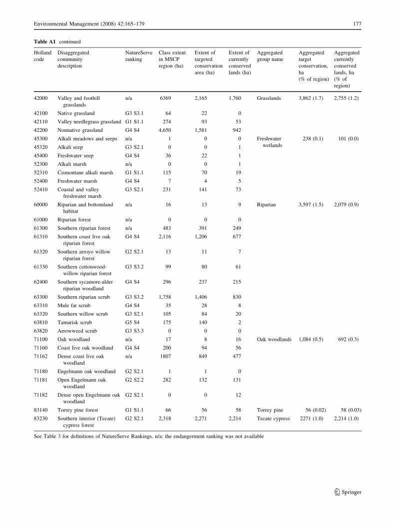
Table A1 continued
Holland
code
Disaggregated
community
description
NatureServe
ranking
Class extent
in MSCP
region (ha)
Extent of
targeted
conservation
area (ha)
Extent of
currently
conserved
lands (ha)
Aggregated
group name
Aggregated
target
conservation,
ha
(% of region)
Aggregated
currently
conserved
lands, ha
(% of
region)
42000 Valley and foothill
grasslands
n/a 6369 2,165 1,760 Grasslands 3,862 (1.7) 2,755 (1.2)
42100 Native grassland G3 S3.1 64 22 0
42110 Valley needlegrass grassland G1 S1.1 274 93 53
42200 Nonnative grassland G4 S4 4,650 1,581 942
45300 Alkali meadows and seeps n/a 1 0 0 Freshwater
wetlands
238 (0.1) 101 (0.0)
45320 Alkali seep G3 S2.1 0 0 1
45400 Freshwater seep G4 S4 36 22 1
52300 Alkali marsh n/a 0 0 1
52310 Cismontane alkali marsh G1 S1.1 115 70 19
52400 Freshwater marsh G4 S4 7 4 5
52410 Coastal and valley
freshwater marsh
G3 S2.1 231 141 73
60000 Riparian and bottomland
habitat
n/a 16 13 9 Riparian 3,597 (1.5) 2,079 (0.9)
61000 Riparian forest n/a 0 0 0
61300 Southern riparian forest n/a 483 391 249
61310 Southern coast live oak
riparian forest
G4 S4 2,116 1,206 677
61320 Southern arroyo willow
riparian forest
G2 S2.1 13 11 7
61330 Southern cottonwood-
willow riparian forest
G3 S3.2 99 80 61
62400 Southern sycamore-alder
riparian woodland
G4 S4 296 237 215
63300 Southern riparian scrub G3 S3.2 1,758 1,406 830
63310 Mule fat scrub G4 S4 35 28 8
63320 Southern willow scrub G3 S2.1 105 84 20
63810 Tamarisk scrub G5 S4 175 140 2
63820 Arrowweed scrub G3 S3.3 0 0 0
71100 Oak woodland n/a 17 8 16 Oak woodlands 1,084 (0.5) 692 (0.3)
71160 Coast live oak woodland G4 S4 200 94 56
71162 Dense coast live oak
woodland
n/a 1807 849 477
71180 Engelmann oak woodland G2 S2.1 1 1 0
71181 Open Engelmann oak
woodland
G2 S2.2 282 132 131
71182 Dense open Engelmann oak
woodland
G2 S2.1 0 0 12
83140 Torrey pine forest G1 S1.1 66 56 58 Torrey pine 56 (0.02) 58 (0.03)
83230 Southern interior (Tecate)
cypress forest
G2 S2.1 2,318 2,271 2,214 Tecate cypress 2271 (1.0) 2,214 (1.0)
See Table 3 for definitions of NatureServe Rankings. n/a: the endangerment ranking was not available
Environmental Management (2008) 42:165–179 177
123

References
Andelman SJ, Groves C, Regan HM (2004) A review of protocols for
selecting species at risk in the context of U.S. Forest Service
viability assessments. Acta Oecologica 26:75–83
Anselin A, Meire PM, Anselin L (1989) Multicriteria techniques in
ecological evaluation: an example using the analytical hierarchy
process. Biological Conservation 49:215–229
Atkinson AJ, Trenham PC, Fisher RN, Hathaway SA, Johnson BS,
Torres SG, Moore YC (2004) Designing adaptive monitoring
programs in an adaptive management context for regional
multiple species conservation plans. Western Ecological
Research Center, U.S. Geological Survey, Sacramento, CA
Austin MP, Margules CR (1984) The concept of representativeness in
conservation evaluation with particular relevance to Australia.
Technical Memorandum 84/11. CSIRO Division of Water and
Land Resources, Canberra
Barrows CW, Swartz MB, Hodges WL, Allen MF, Rotenberry JT,
Li B-L, Scott TA, Chen X (2005) A framework for monitoring
multiple-species conservation plans. Journal of Wildlife Man-
agement 69:1333–1345
Brooks TM, Mittermeier RA, Mittermeier CG, da Fonseca GAB,
Rylands AB, Konstant WR, Flick P, Pilgrim J, Oldfield S,
Magin G, Hilton-Taylor C (2002) Habitat loss and extinction in
the hotspots of biodiversity. Conservation Biology 16:909–923
California Department of Fish and Game (2003) California Fish and
Game Code: section 2800–2835, Natural Community Conser-
vation Planning Act. Available at: http://www.dfg.ca.gov/nccp/
displaycode.html. Accessed February 7, 2007
Chattin L, Rubin L, Mangey D (2006) A winning combination: local land-
use planning and fine-scale vegetation maps. Fremontia 34:9–13
Davis FW, Stine PA, Stoms DM, Borchert MI, Hollander A (1995)
Gap analysis of the actual vegetation of California: 1. The
southwestern region. Madrono 42:40–78
Fahrig L (2002) Effect of habitat fragmentation on the extinction
threshold: A synthesis. Ecological Applications 12:346–353
Figueira J, Greco S, Ehrgott M (eds) (2005) Multiple criteria decision
analysis: state of the art surveys. International Series in Opera-
tions Research & Management Science Vol. 78. Springer, Berlin
Franklin JF (1993) Preserving biodiversity: species, ecosystems, or
landscapes? Ecological Applications 3:202–205
Franklin J, Simons DK, Beardsley D, Rogan JM, Gordon H (2001)
Evaluating errors in a digital vegetation map with forest
inventory data and accuracy assessment using fuzzy sets.
Transactions in Geographic Information Systems 5:285–304
Goodchild MF (1994) Integrating GIS and remote sensing for
vegetation analysis and modeling: methodological issues. Jour-
nal of Vegetation Science 5:615–626
Goodchild MF, Gopal S (eds) (1989) The accuracy of spatial
databases. Taylor & Francis, London
Greer K (2004) Habitat conservation planning in San Diego County:
lessons learned after five years of implementation. Environmen-
tal Practice 6:230–239
Grossman DH, Faber-Langendeon D, Weakley AS, Anderson M,
Bourgeron P, Crawford R, Goodin K, Landaal S, Metzler K,
Patterson K, Pyne M, Reid M, Sneddon L (1998) International
classification of ecological communities: terrestrial vegetation of
the United States, vol 1. The National Vegetation Classification
System: development, status and applications. The Nature
Conservancy, Washington, DC. Available at: http://www.
naturserve.org/library/vol1.pdf. Accessed February 6, 2007
Hanna S (1997) Interior Secretary praises ‘‘monumental conservation
achievement’’ in San Diego County. Press release. U.S. Depart-
ment of Interior, Available at: http://www.doi.gov/news/
archives/sand.html. Accessed February 6, 2007
Holland RF (1986) Preliminary descriptions of the terrestrial natural
communities of California. California Department of Fish and
Game, Sacramento
Jewell SD (2000) Multi-species recovery plans. Endangered Species
Bulletin 25:30–31
Keith DA (1998) An evaluation and modification of World Conser-
vation Union Red List criteria for classification of extinction risk
in vascular plants. Conservation Biology 12:1076–1090
Laurance WF (2000) Do edge effects occur over large spatial scales?
Trends in Ecology and Evolution 15:134–135
Leyva C, Espejel I, Escofet A, Bullock SH (2006) Coastal landscape
fragmentation by tourism development: impacts and conserva-
tion alternatives. Natural Areas Journal 26:117–125
Lowell K, Jaton A (1999) Spatial accuracy assessment: land
information uncertainty in natural resources. Ann Arbor Press,
Chelsea, MI
Luck M, Wu J (2002) A gradient of urban landscape pattern: a case
study from the Phoenix metropolitan region, Arizona, USA.
Landscape Ecology 17:327–339
Margules CR, Pressey RL (2000) Systematic conservation planning.
Nature 405:243–253
Margules CR, Usher MB (1981) Criteria used in assessing wildlife
conservation potential—a review. Biological Conservation
21:79–109
Margules CR, Nicholls AO, Pressey RL (1988) Selecting networks of
reserves to maximize biological diversity. Biological Conserva-
tion 43:63–76
Mazzotti FJ, Morgenstern CS (1997) A scientific framework for
managing urban natural areas. Landscape and Urban Planning
38:171–181
McAlpine CA, Lindenmayer DB, Eyre TJ, Phinn SR (2002)
Landscape surrogates of forest fragmentation: synthesis of
Australian Montreal Process case studies. Pacific Conservation
Biology 8:108–120
McGarigal K (2002) Landscape pattern metrics. In: El-Shaarawi AH,
Piergorsch WW (eds) Encyclopedia of environmetrics. John
Wiley & Sons, Sussex, UK, pp 1135–1142
McGarigal K, Marks BJ (1995) FRAGSTATS: spatial pattern analysis
program for quantifying landscape structure. Available at:
http://www.umass.edu/landeco/research/fragstats/documents/
Metrics/Metrics%20TOC.htm. Accessed February 7, 2007
Medail F, Quezel P (1999) Biodiversity hotspots in the Mediterranean
basin: setting global conservation priorities. Conservation Biol-
ogy 13:1510–1513
Moffett A, Sarkar S (2006) Incorporating multiple criteria into the
design of conservation area networks: a minireview with
recommendations. Diversity and Distributions 12:125–137
Mulder BS, Noon BR, Spies TA, Raphael MG, Palmer CJ, Olsen AR,
Reeves GH, Welsh HH (1999) The strategy and design of the
effectiveness monitoring program for the Northwest Forest Plan.
General Technical Report PNW-GTR-437, U.S. Department of
Agriculture, Forest Service, Pacific Northwest Research Station,
Portland, OR
Myers N, Mittermeier RA, Mittermeier CG, Da Fonseca GAB, Kent J
(2000) Biodiversity hotspots for conservation priorities. Nature
403:853–858
Nicholson E, Wilcove DS (2007) Assessing the threat status of
ecological communities: scale, viability, and ecological theory.
In: Society for Conservation Biology, 21st Annual Meeting, Port
Elizabeth, South Africa, Volume of Abstracts
Noon BR (2003) Conceptual issues in monitoring ecological
resources. In: Busch DE, Trexler JC (eds) Monitoring ecosys-
tems: interdisciplinary approaches for evaluating ecoregional
initiatives. Island Press, Washington, DC, pp 27–72
Noon BR, Spies TA, Raphael MG (1999) Conceptual basis for
designing an effectiveness monitoring program. In: Mulder BS
178 Environmental Management (2008) 42:165–179
123

(ed) The strategy and design of the effectiveness monitoring
program for the Northwest Forest Plan. General Technical
Report PNW-GTR-437. U.S. Department of Agriculture Forest
Service, Portland, OR, pp 21–48
Noss RF (1987) From plant communities to landscapes in conserva-
tion inventories: a look at The Nature Conservancy (USA).
Biological Conservation 41:11–37
Noss RF (1990) Indicators for monitoring biodiversity: a hierarchical
approach. Conservation Biology 4:355–364
Noss RF (1996) Ecosystems as conservation targets. Trends in
Ecology and Evolution 11:351
Olsen AR, Sedransk J, Edwards D, Gotway CA, Liggett W, Rathbun S,
Reckhow KH, Young LJ (1999) Statistical issues for monitoring
ecological and natural resources in the United States. Environ-
mental Monitoring and Assessment 54:1–45
Olsen LM, Dale VH, Foster T (2007) Landscape patterns as indicators
of ecological change at Fort Benning, Georgia, USA. Landscape
and Urban Planning 79:137–149
O’Neill RV, Krummel JR, Gardner RH, Sugihara G, Jackson BJ,
DeAngelis DL, Milne BT, Turner MG, Zygmut B, Christensen S,
Dale VH, Graham RL (1988) Indices of landscape pattern.
Landscape Ecology 1:153–162
Pereira JMC, Duckstein L (1993) A multiple criteria decision-making
approach to GIS-based land suitability evaluation. International
Journal of Geographic Information Systems 7:407–424
Possingham HP, Wilson KA, Andelman SJ, Vynne CH (2006)
Protected areas: goals, limitations and design. In: Groome MJ,
Meffe GK, Carroll CR (eds) Principles of conservation biology,
3rd edn. Sinauer Associates, Sunderland, MA, pp 509–533
Pressey RL, Possingham HP, Logan VS, Day JR, Williams PH (1999)
Effects of data characteristics on the results of reserve selection
algorithms. Journal of Biogeography 26:179–191
Purvis A, Gittleman JL, Cowlinshaw G, Mace GM (2000) Predicting
extinction risk in declining species. Proceedings of the Royal
Society 267:1947–1952
Rahn ME, Doremus H, Diffendorfer J (2006) Species coverage in
multispecies conservation plans: where’s the science? Biosci-
ence 56:613–619
Regan HM, Colyvan M, Markovchick-Nicolls L (2006) A formal
model for consensus and negotiation in environmental manage-
ment. Journal of Environmental Management 80:167–176
Regan HM, Davis FW, Andelman SJ, Widyanata A, Freese M (2007)
Comprehensive criteria for biodiversity evaluation in conserva-
tion planning. Biodiversity and Conservation 16:2715–2728
Regan HM, Hierl LA, Franklin J, Deutchman DH, Schmalbach HL,
Winchell CS, Johnson BS (2008) Species prioritization for
monitoring and management in regional multiple species con-
servation plans. Diversity and Distribution 14:462–471
Riitters KH, O’Neill RV, Hunsaker CT, Wickham JD, Yankee DH,
Timmins SP, Jones KB, Jackson BL (1995) A factor-analysis of
landscape pattern and structure metrics. Landscape Ecology
10:23–39
Rodriguez JP, Balch JK, Rodriguez-Clark KM (2007) Assessing
extinction risk in the absence of species-level data: quantitative
criteria for terrestrial ecosystems. Biodiversity and Conservation
16:183–209
Rubinoff D (2001) Evaluating the California gnatcatcher as an
umbrella species for conservation of southern California coastal
sage scrub. Conservation Biology 15:1374–1383
Sawyer JO, Keeler-Wolf T (1995) A manual of California vegetation.
California Native Plant Society, Sacramento, CA. Available at:
http://davisherb.ucdavis.edu/cnpsActiveServer/hollandlist.asp.
Accessed February 7, 2007
Scott JM, Davis FW, Csuti B, Noss RF, Butterfield B, Groves C,
Anderson H, Caicco S, D’Erchia F, Edwards TC Jr, Ulliman J,
Wright RG (1993) Gap analysis: a geographical approach to
protection of biological diversity. Wildlife Monographs 123:
1–41
Scott JM, Goble DD, Wiens JA, Wilcove DS, Bean M, Male T (2005)
Recovery of imperiled species under the Endangered Species
Act: the need for a new approach. Frontiers of Ecology and the
Environment 3:383–389
Scott TA, Sullivan JE (2000) The selection and design of multiple-
species habitat preserves. Environmental Management 26:
S37–S53
Shearer AW, Mouat DA, Bassett SD, Binford MW, Johnson CW,
Saarinen JA (2006) Examining development-related uncertain-
ties for environmental management: strategic planning scenarios
in Southern California. Landscape and Urban Planning 77:
359–381
Slocombe DS (1998) Defining goals and criteria for ecosystem-based
management. Environmental Management 22:483–493
Sprugel DG (1991) Disturbance, equilibrium, and environmental
variability—What is natural vegetation in a changing environ-
ment? Biological Conservation 58:1–18
Stehman SV, Czaplewski RL (1998) Design and analysis for thematic
map accuracy assessment: fundamental principles. Remote
Sensing of Environment 64:331–344
Stenhouse RN (2004) Fragmentation and internal disturbance of
native vegetation reserves in the Perth metropolitan area,
Western Australia. Landscape and Urban Planning 68:389–401
Stow D, O’Leary J, Hope A (1993) Accuracy assessment of MSCP
GIS vegetation layer. San Diego State University. Prepared for
Ogden Environmental and Energy Services, San Diego, CA
Turner MG, O’Neill RV, Gardner RH, Milne BT (1989) Effects of
changing spatial scale on the analysis of landscape pattern.
Landscape Ecology 3:153–162
U.S. Fish and Wildlife Service (1996) Habitat conservation planning
and incidental take permit processing handbook. U.S. Depart-
ment of the Interior, Fish and Wildlife Service, and U.S.
Department of Commerce, National Oceanic and Atmospheric
Administration National Marine Fisheries Service. Available at:
http://www.fws.gov/endangered/hcp/hcpbook.html. Accessed
April 3, 2007
U.S. Fish and Wildlife Service (2007) Conservation plans and
agreement database. Available at: http://ecos.fws.gov/con-
serv_plans/index.jsp. Accessed February 7, 2007
Westman WE (1981) Factors influencing the distribution of species of
Californian coastal sage scrub. Ecology 62:439–455
Wilson EO (1992) The diversity of life. Norton, New York
Wilson KA, McBride MF, Bode M, Possingham HP (2006) Priori-
tizing global conservation efforts. Nature 440:337–340
Winchell C, Doherty P (2006) Estimation of California Gnatcatcher
pair abundance and occupancy rates. U.S. Fish and Wildlife
Service. Prepared for California Department of Fish and Game,
Sacramento
Yoccoz NG, Nichols JD, Boulinier T (2001) Monitoring of biological
diversity in space and time. Trends in Ecology and Evolution
16:446–453
Environmental Management (2008) 42:165–179 179
123