Assembly District 37 Kern County West Part 32nd DistrictC ALIFORNIA ASSEMBLY DISTRICTS Assembly...
6
Pa c i f i c O c e a n Meiners Oaks Mira Monte Oak View Ojai STECKLE PARK TOLAND PARK Fort Tejon State Historical Park Los Padres National Forest Angeles National Forest Piru Fillmore Santa Paula Frazier Park Lebec Lake of the Woods Pine Mtn Club Carpinteria Ventura County Kern County Los Angeles County Santa Barbara County Rincon Creek Kern County Line Santa Barbara County Line 37th District 32nd District 35th District S MOUNTAIN RD CUDDY VALLEY RD WILLOUGHBY RD CREEK RD SANTA ANA RD FRAZIER MT PARK RD LANCASTER RD ADAMS CANYON RD CANADA LARGA RD LEBEC RD S RICE RD E MAIN ST BURNHAM RD MIL POTRERO HWY PASADENA AVE ALISO CANYON RD SESPE ST SANTA ANA BLVD CUYAMA RD A ST FOR HWY 95 33 33 126 150 150 150 101 L O C K W O O D V A L L EY RD 0 2 4 Miles 6 8 Assembly District 37 West Part Map 1 of 5 32 33 30 37 35 41 38 34 36 53 54 42 59 43 40 39 51 47 55 Kern County Ventura County Los Angeles County Santa Barbara County San Luis Obispo County Pacific Ocean Mapped Area Legend Assembly Boundary State Boundary County Boundary City Boundary Major Highway Other Highway Railroad Outside District Major Landmarks
Transcript of Assembly District 37 Kern County West Part 32nd DistrictC ALIFORNIA ASSEMBLY DISTRICTS Assembly...

Paci ficO
cean
Meiners Oaks
Mira Monte
Oak View
Ojai
STECKLE PARK
TOLAND PARK
Fort TejonState Historical Park
Los Padres National Forest
Angeles
National
Forest
PiruFillmore
SantaPaula
Frazier Park
Lebec
Lake ofthe Woods
Pine MtnClub
Carpinteria
V e n t u r a C o u n t y
K e r n C o u n t y
LosAngelesCounty
SantaBarbaraCounty
Rin
con
Cre
ek
Kern County Line
San
ta B
arba
ra C
ount
y Li
ne
37th District
32nd District
35thDistrict
S MOUNTAIN RD
CUDDY VALLEY RD
WILLOUGHBY RD
CR
EEK
RD
SA
NTA
AN
A R
D
FRAZIER MTPARK RD
LANCASTER RD
ADAMS CANYON RD
CANAD
A LA
RGA
RD
LEBEC R
D
S R
ICE
RD
E MAIN ST
BU
RN
HA
M R
D
MIL POTRERO HWY
PASADENA AVE
ALIS
O C
AN
YON
RD
SE
SP
E S
T
SANTA ANA BLVD
CUYAMA RD
A S
T
FOR HWY 95
33
33
126
150
150
150
101
LOCKWOOD VALLEY RD
0 2 4
Miles
6 8
Assembly District 37West Part
Map 1 of 5
3233
30
3735
41
38
34
36
5354
42
59
434039
51
47
55
Kern County
VenturaCounty Los Angeles
County
Santa BarbaraCounty
San Luis ObispoCounty
Pacific Ocean
MappedArea
Legend
Assembly Boundary
State Boundary
County Boundary
City Boundary
Major Highway
Other Highway
Railroad
Outside District
Major Landmarks
LakeCastaic
L o s P a d r e sN a t i o n a l F o r e s t
A n g e l e sN a t i o n a l F o r e s t
A n g e l e sN a t i o n a l F o r e s t
CASTAIC LAKESTATE REC AREA
ANTELOPE VALLEYPOPPY PRESERVE
OMELVENY PARK
VASQUEZROCKSPARK
Acton
QuartzHill
Piru
ValVerde
Lebec
Moorpark
Lancaster
Roseland
Palmdale
Simi ValleyLos Angeles
SantaClarita
L o s A n g e l e s C o u n t y
Ventura County
CALIFORNIASTATE PRISON
60TH
ST
W
90TH
ST
W
PINE CANYON RD
SOLEDAD CANYON RD
W AVENUE I
FOOTHILL BLVD
W AVE N
50TH
ST
W
W AVENUE F
W AVENUE J
W AVENUE K
SA
ND
CA
NYO
N R
D
SAN FERNANDO RDBIG TUJUNGA CANYON RD
LITTLE TUJUNGA RD
LANCASTER RD
MC
BE
AN
PK
WY
JOHNSON RD
LYONS AVE
BOQUET CANYON RD
LAKE HUGHES RD
GODDE HILL R
D
W AVENUE D
ST
EA
RN
S S
T
W AVENUE O8
TEMPLIN HWY
E FENMORE ST
CH
IQU
ITA
CA
NYO
N R
D
W AVE S
SANFRANCISQUITO
CA
NYO
NR
D
138
5
138
126
126
14
14
5
110th St
State Highway 14
State Highway 126
Davenport Rd
Elizabeth Lake Rd
Scarab Fire Rd
1st St
W Avenue J
105th St
120th St
Salt Creek Fire RoadBroadoaks Rd
Harraca Springs Rd
Leona Divide Fire Road
Tripps Gas Line R
d
Farmer John Lat
Tripps Canyon Rd
Oak Ridge Rd
Boiling P
oint RdAgua D
ulce Canyon R
d
California Aqueduct
W Avenue I
San
Fra
ncis
quito
Can
yon
Rd
San
Fran
cisq
uito
Mtw
y
Map
le C
anyo
n C
reek
Middle Ridge
Fire Road
Ritter Mtwy
Ward R
d
Sierra Pellona
Mtwy
Cherokee Canyon Ln
Los Alam
os Canyon R
d
N Tapo R
d
290th St
Angeles National Forest Bdy
37th District
38th District
36thDistrict
59th District
34th District32nd District
0 2 4 6 8
Miles
3233
30
3735
41
38
34
36
5354
42
59
434039
51
47
55
Kern County
VenturaCounty
Los AngelesCounty
Santa BarbaraCounty
San Luis ObispoCounty
Pacific Ocean
MappedArea
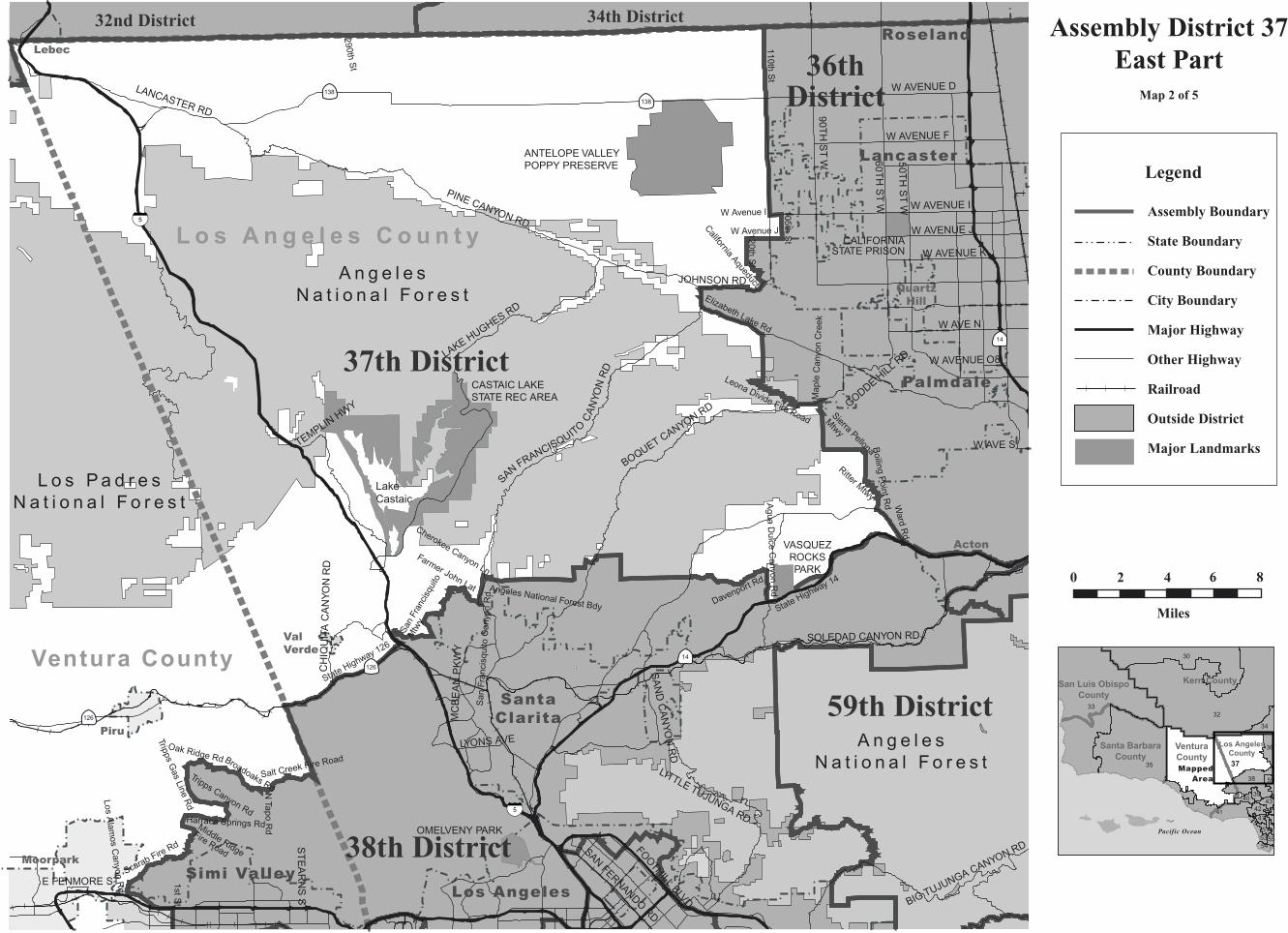
Assembly District 37East Part
Map 2 of 5
Legend
Assembly Boundary
State Boundary
County Boundary
City Boundary
Major Highway
Other Highway
Railroad
Outside District
Major Landmarks
LA County
LA County
VenturaCounty
V e n t u r a C o u n t y L o s A n g e l e s C o u n t y
37th District
38th District
41st District
40th District
DE
SO
TO A
VE
WIN
NE
TK
A A
VE
TOPA
NG
A B
LVD
VANOWEN ST
ROYAL AVE
VICTORY BLVD
OXNARD ST
SATICOY ST
SHERMAN WAY
FALLB
RO
OK
AV
E
VALLEY CIRCLE BLVD
KANAN RD
BURBANK BLVD
MADERA RD
WELLS DR
PLUMMER ST
AGOURA RD
FITZGERALD RD
SIN
ALO
A R
D
CHATSWORTH ST
MARILLA ST
RAMBLING RD
ALAMO ST
LOS ANGELES AVE
THOUSAND OAKS BLVD MULHOLLAND DR
SY
CA
MO
RE
DR
COCHRAN ST
TAP
O C
AN
YON
RD
BO
X C
AN
YON
RD
TAMPA AVE
MULHOLLAND HWY
WALNUT ST
DRIVER AVE
SESNON BLVD
E EASY ST
WO
OD
LAK
E A
VE
ST
EA
RN
S S
T
SE
QU
OIA
AV
E
YOS
EM
ITE
AV
E
WO
OD
RA
NC
H P
KW
Y
W EASY ST
ARCANE ST
TIERRA REJADA RD
BA
DE
N A
VE
SU
NN
YD
ALE
AVE
MA
SO
N A
VE
TE
XA
S A
VE
KU
EH
NE
R D
R
HU
DS
PE
TH
ST
RE
YE
S A
DO
BE
RD
STONEBROOK ST
AR
GO
S S
T
AP
PLE
TON
RD
LOS
T HILLS
RD
CH
ES
EB
RO
RD
LIBE
RT
Y C
AN
YON
RD
CA
NO
GA
AV
E
PLAT
T A
VE
AGOURA RD
VALL
EY C
IR. B
L.
27
27
118
118
101
101
BELL CANYONPARK
KNAPP RANCHPARK
CHATSWORTH OAKSPARK
CHATSWORTH PARKSOUTH
STONEY POINT PARK
CHATSWORTHPARK NORTH
OAKWOOD CEMETERYAGGELERHIGH SCHOOL
CHATSWORTH HIGH SCHOOL
ROYAL HIGH SCHOOL
SIMI VALLEY HIGH SCHOOL
SIMI VALLEY HOSPITAL
Santa Monica Mountains National Recreation Area
VALL
EYCIRCLE BLVD
ThousandOaks
OakPark
Agoura HillsHidden Hills
CalabasasWestlakeVillage
Simi Valley
Moorpark
City of Los Angeles
Chatsworth
WestHills
WoodlandHills
Roscoe Blvd
1st St
Royal Ave
Lim
ekiln
Cre
ek
Lind
ero
Can
yon
Rd
Dayton Canyon Rd
Nordhoff St
Plummer St
Devonshire St
Bro
wns
Cre
ek C
hann
el
Erringer R
d
Halsted St
Los Alam
os Canyon R
d
Kuehner Dr
Oak
dale
Ave
Middle Ridge Fire Road
Scara
bFi
reRoad
Union Pacific Railroad
Santa Susana Pass Rd
118 Freeway
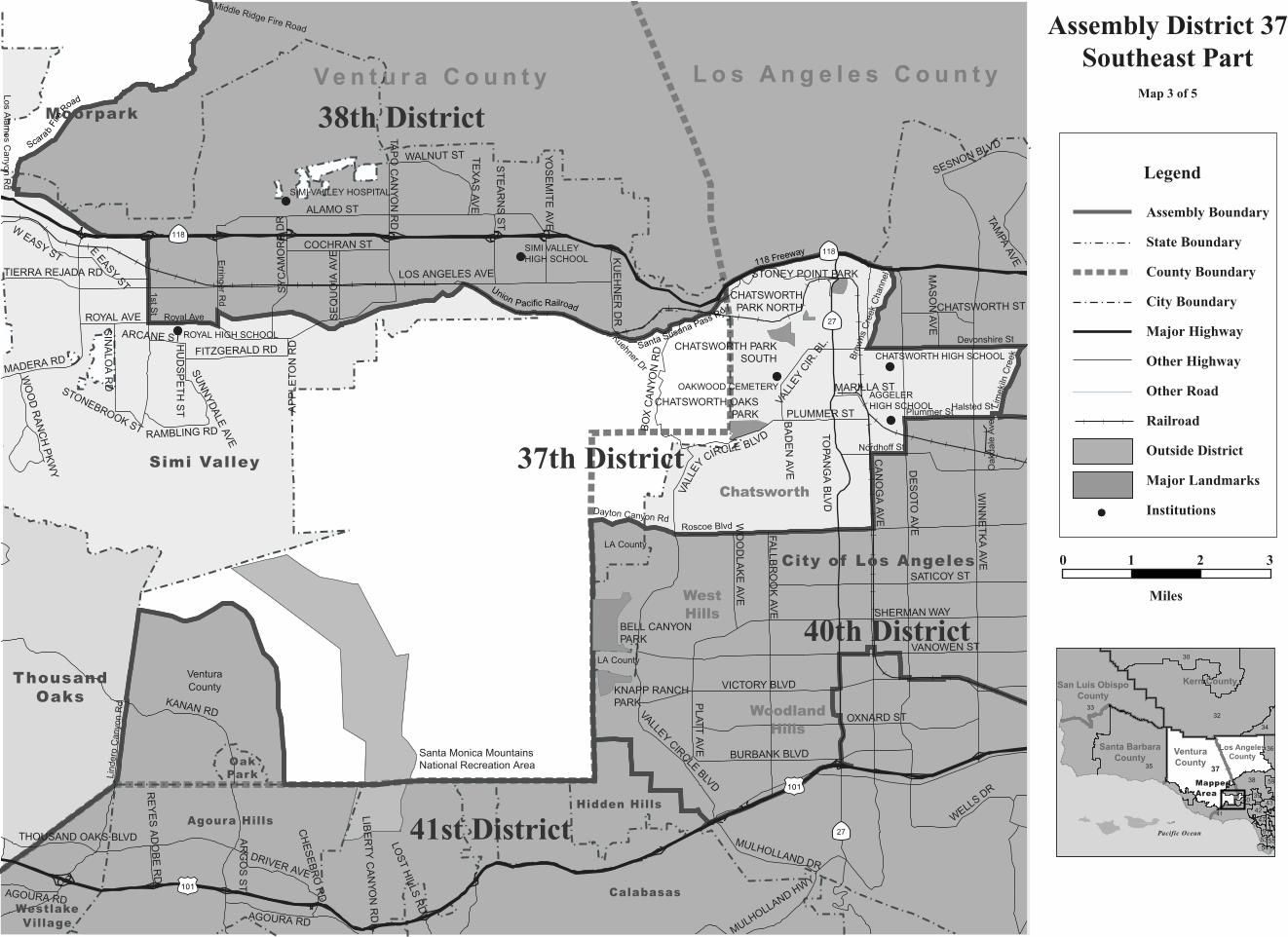
Assembly District 37Southeast Part
Map 3 of 5
3233
30
3735
41
38
34
36
5354
42
59
434039
51
47
55
Kern County
VenturaCounty
Los AngelesCounty
Santa BarbaraCounty
San Luis ObispoCounty
Pacific Ocean
0 1 2
Miles
3
MappedArea
Legend
Assembly Boundary
State Boundary
County Boundary
City Boundary
Major Highway
Other Highway
Other Road
Railroad
Outside District
Major Landmarks
Institutions

P a c i f i cO
ce
an
23
WESTLAKECOMMUNITY
HOSPITAL
Santa Monica Mountains
National Recreation Area
Santa Monica MountainsNational Recreation Area
Santa Monica MountainsNational Recreation Area
SANTA MONICA MTNS NRA
MALIBU CREEK STATE PARK
LEO CARRILLOSTATE BEACH
POINT DUME STATE BEACH
ROBERT MEYERMEM STATE BEACH
CHUMASH PARK
AGOURA PARK
REYESADOBE
PARK
SUMAC PARK
POINT MUGUSTATE PARK
MALIBU LAGOONSTATE BEACH
FORESTCOVEPARK
Agoura Hills
Calabasas
Malibu
WestlakeVillage
Thousand Oaks
Simi Valley
HiddenHills
OakPark
Los Angeles County
Ve n t u r a C o u n t y
Potrero Rd
Lind
ero
C
anyo
n R
d
Ventu Park Rd
Lynn Rd
Dayton Canyon Rd
La Venta Rd
Map
le
R
d
PotreroRd
United StatesHighway 101
McK
night Rd
41st District
37th District
Coombs Rd
Lake Sherwood Dr
Carlisle Rd
1
1
LYNN RD
MO
OR
PAR
K R
D
KANAN RD
WE
ST
LAK
E B
LVD
ER
BE
S R
D
THOUSAND OAKS BLVD
JANSS RD
BORCHARD ST
AGOURA RD
CO
UN
TY
HW
Y N
1
JANSS RD
HILLCREST DR
KANAN RD23
POTRERO RD
101
101
101
KANANDU
ME
RD
MULH
OLLAND HWY
ENCINAL CANYON RD
DEC
KER
RD
MULHOLLAND HWY
MALIBU
CA
NYO
NR
D
CO
UNT
Y
HWY N9
Assembly District 37Thousand Oaks Detail
Map 4 of 5
0 1 2
Miles
3233
30
3735
41
38
34
36
5354
42
59
434039
51
47
55
Kern County
VenturaCounty
Los AngelesCounty
Santa BarbaraCounty
San Luis ObispoCounty
Pacific Ocean
MappedArea
Legend
Assembly Boundary
State Boundary
County Boundary
City Boundary
Major Highway
Other Highway
Railroad
Outside District
Major Landmarks

Oxnard Airport
Harb
or B
lvd
ST JOHNSPLEASANT VALLEY
HOSP
ST JOHNS REGIONALMEDICAL CENT
CHANNEL ISLANDSCOMMUNITY HOSP
PacificMissle
Test Center
POINT MUGU STATE PARK
MCGRATHSTATEBEACH
MANDALAYSTATE BEACH
OXNARD STATE BEACH
Santa Monica MountainsNational Recreation Area
Santa Monica Mountains
National Recreation Area
POINT MUGU
AIR WEAPONS STA
PORT HUENEME
NAVAL CTR
Oxnard
VenturaEl Rio
Camarillo
ThousandOaks
PortHueneme
41st District
37th District35th District
Ventura County
Pleasant Valley Rd
Pa
nch
o R
d
Potrero Rd
San
ta C
lara
Ave
Wright R
d
Bea
rdsley
Rd
Howard Rd
Wo
od
Rd
Ventura Blvd
Central
Ave
Edison Rd
Adohr Ln
LA
S P
OS
AS
RD
S L
EW
IS R
D
HUENEME RD
SA
VIE
RS
RD
UPLAND RD
LA
S P
OS
AS
RD
AR
NE
ILL R
D
HUENEME RD
OC
EAN
DR
WO
OD
RD
SANTA ROSA RDCA
RM
EN
DR
POSAS RD
101
101
101
1
34
POTRERO RD
1
34
OX
NA
RD
BL
5TH ST
34
PLEASANT
VA
LLEY
RD
Assembly District 37Southwest Part
Map 5 of 5
0 1 2
Miles
P a c i f i cO
ce
an
32
33
30
3735
41
38
34
36
53
54
42
59
4340
39
51
47
55
Kern County
VenturaCounty Los Angeles
County
Santa BarbaraCounty
San Luis ObispoCounty
MappedArea
Pacific Ocean
Legend
Assembly Boundary
State Boundary
County Boundary
City Boundary
Major Highway
Other Highway
Other Road
Railroad
Outside District
Major Landmarks
Institutions
C A L I F O R N I A A S S E M B LY D I S T R I C T S
Assembly Redistricting Plan (SB 802), September 13, 2001
The Honorable Robert M. Hertzberg, SpeakerState CapitolRoom 219Sacramento, CA 95814
The California State Assembly Rules CommitteeThe Honorable Dennis Cardoza, ChairP.O. Box 942849Sacramento, CA 94249-0001
The California State Assembly Committee on Elections, Reapportionment, and Constitutional AmendmentsThe Honorable John Longville, ChairP.O. Box 942849Sacramento, CA 94249-0001
Produced at California State University NorthridgeDr. Jolene Koester, President
Eugene Turner, Project DirectorDepartment of Geography18111 Nordhoff St.Northridge, CA 91330
with
Rubyjane Domingo, Pat Jolley, Meredith Leonard
2001
About the Maps
These maps present specific informationabout the features comprising the borders of theAssembly Districts of California that were cre-ated after the 2000 Census. Each of the 80 dis-tricts are represented by one to ten maps withthe number depending on the size of the districtand the complexity of the features followed bythe boundary. In general, the boundaries followcounty lines, city limit lines, and roads, butoccasionally canals, streams, and small roadsare followed.
The Assembly boundary data were creat-ed in digital form from Census 2000 TIGERfiles for California by Pactech Incorporated ofPasadena, CA. The boundary files were releasedin two forms, as a file of district polygons andas a file of line segments used to create thepolygons. Where these line segments were iden-tified, those identifiers were used to label themap boundaries. In addition, place boundarieswere created from the TIGER files.
Other map information such as roads,railroads, coastlines, and landmarks wereobtained from Geographic Data Technologies.Dynamap 2000 files (v10.1). Government landownership information such as national forestboundaries was obtained from a governmentland ownership layer prepared by the CaliforniaTeale Data Center.
Maps were prepared from the digitalfiles using Arcmap 8.1 software fromEnvironmental Systems Research Incorporated.An Albers equal area projection was used forthe maps with a central meridian of 120 degreeswest longitude and standard parallels of 30 and40 degrees of latitude. Coordinates are based onNAD83.
conneljw
About the Maps These maps present specific information about the features comprising the borders of the Assembly Districts of California that were created after the 2000 Census. Each of the 80 districts are represented by one to ten maps with the number depending on the size of the district and the complexity of the features followed by the boundary. In general, the boundaries follow county lines, city limit lines, and roads, but occasionally canals, streams, and small roads are followed. The Assembly boundary data were created in digital form from Census 2000 TIGER files for California by Pactech Incorporated of Pasadena, CA. The boundary files were released in two forms, as a file of district polygons and as a file of line segments used to create the polygons. Where these line segments were identified, those identifiers were used to label the map boundaries. In addition, place boundaries were created from the TIGER files. Other map information such as roads, railroads, coastlines, and landmarks were obtained from Geographic Data Technologies. Dynamap 2000 files (v10.1). Government land ownership information such as national forest boundaries was obtained from a government land ownership layer prepared by the California Teale Data Center. Maps were prepared from the digital files using Arcmap 8.1 software from Environmental Systems Research Incorporated. An Albers equal area projection was used for the maps with a central meridian of 120 degrees west longitude and standard parallels of 30 and 40 degrees of latitude. Coordinates are based on NAD83.